Next Article in Journal
Development and Validation of an Enhanced Aerosol Product for Aeolus (L2A+)
Previous Article in Journal
The HEAT-ALARM Project: Development of a Heat–Health Warning System in Greece
 
 
Please note that, as of 4 December 2024, Environmental Sciences Proceedings has been renamed to Environmental and Earth Sciences Proceedings and is now published here.
Proceeding Paper

The High-Resolution Numerical Weather Prediction System of the Agroray Project †

by
Ioannis Pytharoulis
1,2,*,
Stergios Kartsios
1,
Vassilios Kostopoulos
3,
Christos Spyrou
3,4,
Ioannis Tegoulias
1,5,
Dimitrios Bampzelis
1 and
Prodromos Zanis
1,2
1
Laboratory of Meteorology and Climatology, School of Geology, Aristotle University of Thessaloniki, 54124 Thessaloniki, Greece
2
Center for Interdisciplinary Research and Innovation (CIRI-AUTH), Balkan Center, Buildings A & B, 10th km Thessaloniki-Thermi Rd., 57001 Thessaloniki, Greece
3
Raymetrics S.A., 14452 Athens, Greece
4
Research Centre for Atmospheric Physics and Climatology, Academy of Athens, 10679 Athens, Greece
5
ELGA-Meteorological Applications Center, 57001 Thessaloniki, Greece
*
Author to whom correspondence should be addressed.
Presented at the 16th International Conference on Meteorology, Climatology and Atmospheric Physics—COMECAP 2023, Athens, Greece, 25–29 September 2023.
Environ. Sci. Proc. 2023, 26(1), 90; https://doi.org/10.3390/environsciproc2023026090
Published: 28 August 2023

Abstract

:
The Agroray project was aimed at the development of a high-resolution numerical weather prediction system that will allow farmers to optimize their activities and protect their products from adverse weather events. The system is based on the Weather Research and Forecasting model and focuses on Central Macedonia with a horizontal grid spacing of 1 km. The aim of this article is to describe the model configuration and validate its performance during selected frost and intense precipitation events. The evaluation against station measurements and radar precipitation showed that the optimum model setup includes Corine land use and enhanced vertical resolution near the surface.

1. Introduction

Numerical weather prediction (NWP) has achieved great progress in recent decades [1]. Successful forecasts are important for the planning of everyday activities, tourism, transportation, agriculture, etc. Various global and limited-area models are used to predict the meteorological conditions over Greece (e.g., [2,3,4,5]).
Central Macedonia has a vital role in the economy of Greece. Raymetrics S.A. and the Laboratory of Meteorology and Climatology of the Aristotle University of Thessaloniki (LMC/AUTH) collaborated in the Agroray project (entitled “Development of a forecasting system and geographical indicators for the agriculture”) in order to develop an operational high-resolution NWP system for Northern Greece, focusing on Pieria and its surrounding regions. Timely and valid forecasts with high spatiotemporal resolution allow local farmers to optimize their activities and protect their production from intense or high-impact weather events. The existing operational modeling systems either employ a coarser spatial resolution and/or have not been optimized specifically in the area of interest.
The optimum configuration of an operational NWP system remains an important challenge. This is particularly difficult in the area of interest, which is characterized by the significant variability of its physiographic characteristics and frequently affected by adverse weather conditions. The aims of this study were as follows: (a) to present the setup of the NWP system of the Agroray project and (b) to validate its performance during selected intense weather events.

2. Materials and Methods

2.1. Model Setup

The NWP system is based on the non-hydrostatic Weather Research and Forecasting model with advanced research dynamics (WRF-ARW version 4.3.3). It employs three (1-way) telescoping nests to cover: (i) Europe, the Mediterranean Sea and Northern Africa (d01), (ii) a large part of Greece (d02) and (iii) Central Macedonia and parts of Thessaly and Western Macedonia (d03), at horizontal grid spacings of 9 km, 3 km and 1 km, respectively (Figure 1a). The initial and boundary conditions were provided by the NCEP/GDAS (National Centers for Environmental Prediction/Global Data Assimilation System) analyses (0.25° × 0.25°). The topography and land use were based on the high-resolution datasets of the United States Geological Survey (USGS). The microphysics, cumulus convection, radiation, boundary layer, surface layer and soil processes were parameterized by the WSM6, Kain-Fritsch (only in d01), RRTMG, Mellor-Yamada-Janjic, Eta and NOAH schemes.
Two sets of experiments are presented in this article:
-
Number and distribution of hybrid vertical levels: (a) 39 levels defined manually with enhanced resolution near the surface (hereafter 39-Manual; operationally used by LMC/AUTH [2]); (b) 50 levels defined by WRF (50-WRF); (c) 50 levels defined by WRF, with a higher resolution in the lower troposphere (stretched) and the lowest level at 20 m aboveground (50-WRFS); (d) 80 levels defined by WRF (80-WRF). The model top was set at 50 hPa.
-
Land use data: USGS in d01, d02 and (a) USGS in d03 (USGS), (b) Corine (COoRdination of INformation on the Environment) in d03 reclassified in the USGS categories (Corine) [6]. The vertical levels of 50-WRFS were used in these simulations.
It is noted that the experiments 50-WRFS and USGS adopted the same setup. However, the experiments with different vertical levels were performed at a different computer cluster from the ones with the two land use datasets. Therefore, some minor differences are likely between 50-WRFS and USGS, but they will not be discussed because they are out of the scope of this study and do not affect its conclusions.

2.2. Cases, Data and Statistical Evaluation

The numerical experiments were performed in three cases of frost and three cases of intense precipitation. The frost events fell on the following dates: (a) 6–15 January 2017 with a minimum temperature of −11.1 °C in Dion, Pieria (Figure 1b); (b) 28 February–2 March 2018 with a minimum temperature of −3.6 °C in Dion; and (c) 17 March 2020 with a minimum temperature of −1.2 °C in Katachas, Pieria (Figure 1b). The precipitation events fell on the following dates: (a) 12–14 March 2016 (118.8 mm over 3 days of precipitation in Dion); (b) 15–17 November 2017 (419.4 mm over 3 days of precipitation in Dion); and (c) 25 March 2018 (105.4 mm of daily precipitation in Dion).
The experiments had a duration of 2.5 days (except for the last day in each case), were initialized daily at 1200 UTC and were evaluated only for the above periods. For every case, the first simulation was initialized at 1200 UTC two days before the first day. The last simulation of each case was initialized at 1200 UTC the day before the last one and had a duration of 1.5 forecast days. In this way, every day of the selected cases could be simulated with a horizon of one forecast day (12–36 h) and two forecast days (36–60 h).
The meteorological measurements that were used in the model evaluation were provided by (a) LMC/AUTH in AUTH, KEOAX and Delta Axios; (b) the Hellenic National Meteorological Service (HNMS) at the airports of Thessaloniki (LGTS) and Kozani (LGKZ); (c) 3D S.A. in Katachas; (d) the National Observatory of Athens (NOA) in N. Michaniona, Korinos, Dion, Elassona, Gonnoi and Velventos; and (e) the Greek Agricultural Insurance Organization (ELGA) in Meliki (Figure 1b). The precipitation was estimated utilizing the weather radar data of 3D S.A. atFilyro, Thessaloniki (Figure 1b), which isused operationally by the ELGA for hail suppression purposes, following [7].
The d03-simulated 2m temperature (T2), 2m relative humidity (RH2) and 10m wind speed (WS10) were evaluated at 30-minute intervals (upon availability of observations) in all cases, using the mean error (ME; model–observation) and the mean absolute error (MAE). The values of the four surrounding grid-points were interpolated at the location of each station. The simulated 6h accumulated precipitation of d03 was evaluated only in the intense precipitation cases against the radar-estimated precipitation, using the neighborhood-based technique of [8]. The scores were derived for “neighborhoods” (squares centered at each grid-point) with a side length of 1–61 km (at intervals of 2 km) for different precipitation thresholds (1, 10 mm/6 h). A hit was considered in a given neighborhood when the observation and at least half of the model grid-point values exceeded the threshold.

3. Results

3.1. Continuous Variables

Table 1 and Table 2 present the model errors of continuous variables for the two sets of experiments (vertical levels, land use) for the frost and intense precipitation cases, respectively. The errors were averaged from the 12th to the last forecast time, as long as the valid time lies within the periods of the selected events. The temperature at 2 m was overestimated in almost all the experiments. The relative humidity was underestimated in all runs with intense precipitation. The wind speed at 10 m was generally overestimated (underestimated) in the experiments with intense precipitation (frost).
Regarding the experiments of the frost events with different vertical levels (Table 1), 50-WRFS exhibited the lowest MAE of T2 (2.85 K), RH2 (13.45%) and WS10 (4.03 m/s). This resulted in the occurrence of the highest skill score being achieved by 50-WRFS relative to any other experiment (e.g., +0.53% relative to 39-Manual for the frost cases). In the intense precipitation cases, the MAEs of 50-WRFS were 1.46 K in T2, 7.1% in RH2 and 4.03 m/s in WS10 (Table 2). Although these errors were not always the lowest among the experiments with different vertical levels in the intense precipitation cases, the skill score of 50-WRFS averaged for all the continuous variables was the highest (e.g., +0.69% relative to 39-Manual).
It seems that the higher near-surface vertical resolution imposed by 50-WRFS relative to all the other experiments results in a reduction in the errors of the continuous variables, but to a very small extent. Furthermore, 39-Manual, 50-WRF, 50-WRFS and 80-WRF employ 9, 7, 11 and 7 vertical levels in the lowest 1 km, with the lowest level located at about 20, 50, 20 and 50 m aboveground, respectively. Therefore, the combination of the increased number of lower tropospheric vertical levels and the reduced height of the lowest model level allowed 50-WRFS to improve the representation of the lower tropospheric processes.
The use of the Corine land use data, instead of the USGS in d03, improved the MAE of almost all the continuous variables, except for RH2, in the intense precipitation experiments (Table 1 and Table 2). The MAE of the frost (intense precipitation) experiments was equal to 2.57 K (1.37 K) for T2, 13.38% (7.76%) for RH2 and 4.01 m/s (3.91 m/s) for WS10 when the Corine data were used. These values are within the range of model errors or lower than the ones that appear in the literature in simulations of intense weather events (e.g., storms associated with floods, tornadoes, Vardaris wind episode) in the area of interest and Greece (e.g., [7,9,10]). The overall average skill score of Corine relative to USGS reached 2.23% (for all cases and continuous variables).

3.2. Precipitation

Table 3 displays the statistical scores of the Probability of Detection (POD), False-Alarm Ratio (FAR) and Equitable Threat Score (ETS), which accounts for hits due to chance, at the thresholds of 1 mm/6 h and 10 mm/6 h. They were calculated in d03 only for the intense precipitation events, against the radar-estimated precipitation, using the neighborhood-based approach. Each score corresponds to the mean value for all neighborhood sizes and 6h forecast periods from the 12th forecast hour to the end of each run, as long as the valid times lie within the periods of the selected events.
Among the runs with different vertical levels (Table 3), it is clear that the experiment 50-WRFS produced the best representation of the precipitation at both thresholds, which correspond to weak (1 mm/6 h) and intense precipitation (10 mm/6 h). Only 80-WRF exhibited a better score than 50-WRFS (i.e., a lower FAR) at the threshold of 1 mm/6 h. It is recognized that the differences among the scores of the different vertical configurations are small. Therefore, similar to what was seen for the continuous variables, the enhanced vertical resolution of 50-WRFS appears to be more important than having a larger number of levels (80-WRF) for the simulation of precipitation.
The use of USGS land use data led to a higher POD, FAR and ETS than the Corine data at the precipitation threshold of 1 mm/6 h (Table 3). The predictability was reduced and the number of false alarms increased for both land use datasets when stronger precipitation events were considered. At the threshold of 10 mm/6 h, the Corine experiments exhibited a higher POD, ETS and lower FAR than USGS, but with very small differences.

3.3. The Operational NWP System

The final configuration of the NWP system is similar to the one presented in Section 2.1, but with the vertical levels of the experiment 50-WRFS, Corine land use in d03, NASA Shuttle Radar Topographic Mission topography, Copernicus Marine Environment Monitoring Service sea-surface temperatures (SSTs), Thompson two-moment microphysics and the quasi-normal scale elimination boundary and surface layer schemes. This setup resulted from a study on model sensitivity for alternative topography and SST datasets, as well as a study on boundary/surface layer, soil and microphysical parameterizations. However, the presentation of these results falls beyond the scope of this article.
The Agroray project produces operational 2.5-day forecasts, initialized daily at 1200 UTC. Various forecasts of interest for farmers and the general public are available, free of charge, in the webpage of the project (Figure 2; http://www.meteoray.com, accessed on 23 August 2023). Predictions of disease indices for wheat and grapes are also included. Finally, the observations of the automatic meteorological stations that were installed for the project in Litochoro, Katerini, Katachas, Velventos and Naoussa (Figure 1b and Figure 2) are provided.

4. Discussion and Conclusions

The Agroray project was aimed at the development of a high-resolution NWP system based on the non-hydrostatic WRF model, which produces operational forecasts for Pieria and the surrounding areas at a grid spacing of 1 km. Moreover, the weather conditions of Central and Northern Greece are predicted at 3 km. The forecasts are available free of charge on the internet (http://www.meteoray.com, accessed on 23 August 2023). The system was optimized through a series of sensitivity experiments. This article shows that the use of enhanced vertical resolution in the lowest troposphere leads to better forecasts than simply increasing the total number of model vertical levels. This is likely to be due to a better representation of the boundary layer processes and the transfer of surface fluxes of energy. The introduction of the up-to-date Corine land use dataset, instead of the USGS one, in the inner model domain (with the finest resolution) improved the spatial variability of the land uses, enhancing the statistical scores of the continuous variables and the precipitation, especially for intense events.

Author Contributions

Conceptualization, V.K. and I.P.; methodology, I.P., S.K., V.K., C.S., I.T., D.B. and P.Z.; software, I.P., S.K. and C.S.; validation, I.P., S.K., C.S., I.T., D.B. and P.Z.; formal analysis, I.P.; investigation, I.P. and S.K.; resources, I.P., S.K., V.K. and C.S.; data curation, I.P., S.K., C.S., I.T. and D.B.; writing—original draft preparation, I.P.; writing—review and editing, I.P., S.K., V.K., C.S., I.T., D.B. and P.Z.; visualization, I.P., S.K. and C.S.; supervision, I.P.; project administration, I.P. and V.K.; funding acquisition, I.P. and V.K. All authors have read and agreed to the published version of the manuscript.

Funding

This research was carried out as part of the Agroray project, entitled “Development of a forecasting system and geographical indicators for the agriculture” (project code: KMP6-0078047) under the framework of the action “Investment Plans of Innovation” of the Operational Program “Central Macedonia 2014–2020”, which is co-funded by the European Regional Development Fund and Greece.

Institutional Review Board Statement

Not applicable.

Informed Consent Statement

Not applicable.

Data Availability Statement

The data presented in this study are available on request from the corresponding author.

Acknowledgments

We thank NCAR, UCAR/DTC, NCEP, USGS and Copernicus for providing the WRF numerical model, the Model Evaluation Tools (MET) software and the gridded meteorological and land use input data. The statistics were calculated via MET, NCL and Microsoft Excel.

Conflicts of Interest

The authors declare no conflict of interest. The funders had no role in the design of the study; in the collection, analyses, or interpretation of data; in the writing of the manuscript; or in the decision to publish the results.

References

  1. Bauer, P.; Thorpe, A.; Brunet, G. The quiet revolution of numerical weather prediction. Nature 2015, 525, 47–55. [Google Scholar] [CrossRef] [PubMed]
  2. Pytharoulis, I.; Tegoulias, I.; Kotsopoulos, S.; Bampzelis, D.; Karacostas, T.; Katragkou, E. Evaluation of the operational numerical weather predictions of the WaveForUs project. In Proceedings of the 12th International Conference on Meteorology, Climatology and Atmospheric Physics (COMECAP2014), Heraklion, Greece, 28–31 May 2014. [Google Scholar]
  3. Boucouvala, D.; Andreadis, T.; Gofa, F. Verification Results for Greece. In Reports on ICON; Issue 6; Rast, S., Redler, R., Reinert, D., Rieger, D., Prill, F., Eds.; Deutscher Wetterdienst: Offenbach, Germany, 2021; pp. 9–12. [Google Scholar]
  4. Katsafados, P.; Mavromatidis, E.; Gkikas, N.; Papadopoulos, A. The numerical weather prediction system of Harokopio University and statistical evaluation of the forecasts. Geographies 2012, 20, 79–98. [Google Scholar]
  5. ECMWF, Implementation of IFS Cycle 47R3. Available online: https://confluence.ecmwf.int/display/FCST/Implementation+of+IFS+Cycle+47r3 (accessed on 30 May 2023).
  6. Pineda, N.; Jorba, O.; Jorge, J.; Baldasano, J.M. Using NOAA AVHRR and SPOT VGT data to estimate surface parameters: Application to a mesoscale meteorological model. Int. J. Remote Sens. 2004, 25, 129–143. [Google Scholar] [CrossRef]
  7. Pytharoulis, I.; Kotsopoulos, S.; Tegoulias, I.; Kartsios, S.; Bampzelis, D.; Karacostas, T. Numerical modeling of an intense precipitation event and its associated lightning activity over northern Greece. Atmos. Res. 2016, 169, 523–538. [Google Scholar] [CrossRef]
  8. Clark, A.J.; Gallus, W.A., Jr.; Weisman, M.L. Neighborhood-based verification of precipitation forecasts from convection-allowing NCAR WRF model simulations and the operational NAM. Weather Forecast. 2010, 25, 1495–1509. [Google Scholar] [CrossRef]
  9. Matsangouras, I.; Pytharoulis, I.; Nastos, P.T. Numerical modeling and analysis of the effect of complex Greek topography on tornadogenesis. Nat. Hazards Earth Syst. Sci. 2014, 14, 1905–1919. [Google Scholar] [CrossRef]
  10. Tsopouridis, L.; Pytharoulis, I.; Karacostas, T.; Zanis, P.; Tegoulias, I. Numerical study of an intense episode of Vardaris wind. In Advances in Meteorology, Climatology and Atmospheric Physics; Helmis, C.G., Nastos, P.T., Eds.; Springer Atmospheric Sciences: Berlin/Heidelberg, Germany, 2012; pp. 325–332. [Google Scholar]
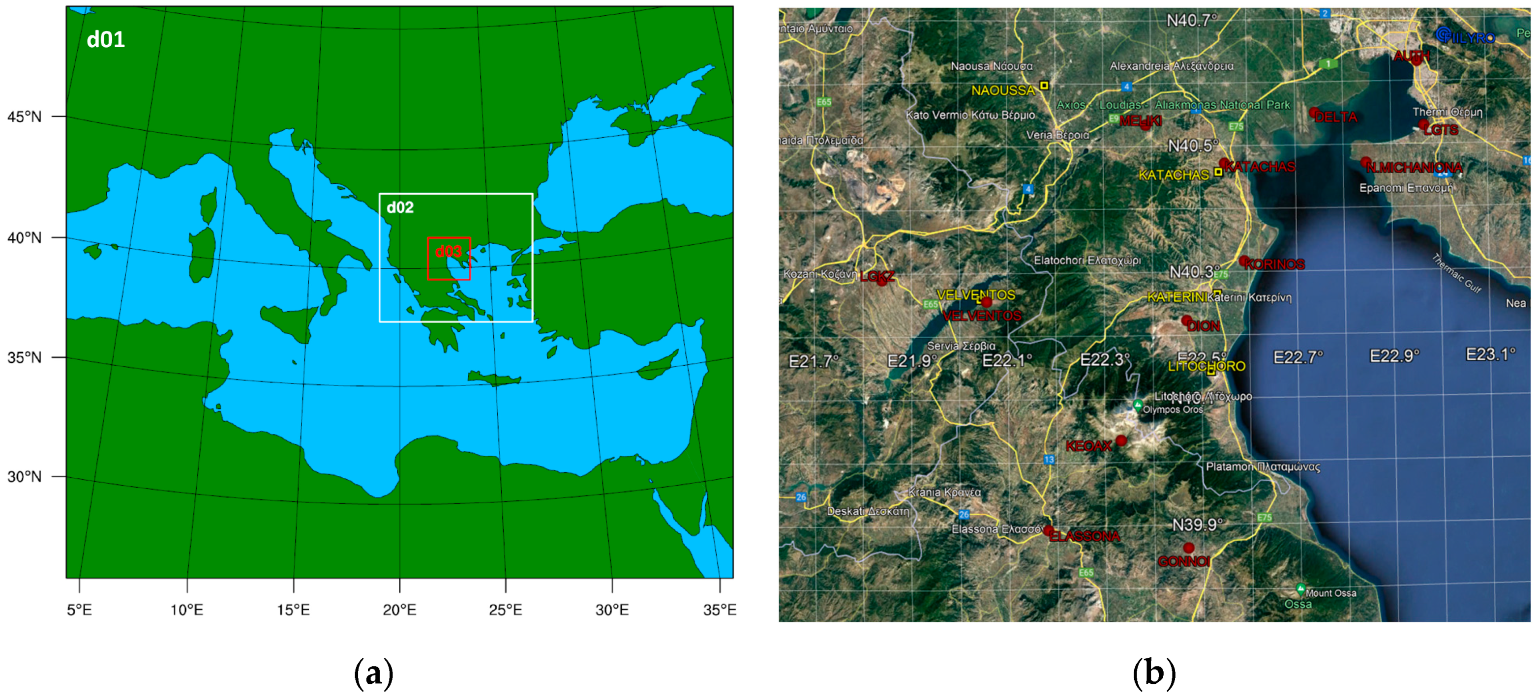
Figure 1. (a) The three telescoping nests of the WRF-ARW modeling system; (b) the meteorological stations used in the evaluation (red), the automatic ones installed during the Agroray project (yellow) and the weather radar in Filyro, Thessaloniki (blue) (Google Earth).
Environsciproc 26 00090 g001
Figure 2. Visualization of an operational forecast of 10m wind speed (m/s) in d03, from the webpage of the Agroray project (http://www.meteoray.com, accessed on 23 August 2023) with the logo of the funding authorities.
Environsciproc 26 00090 g002
Table 1. MAE of the frost experiments with different vertical levels and land uses in d03. Bold (italic) values denote that the WRF-d03 overestimates (underestimates) the observations, ME > 0 (<0).
Experiment39-Manual50-WRF50-WRFS80-WRFUSGSCorine
T2 (K)2.872.932.852.942.862.57
RH2 (%)13.5713.9213.4513.9813.4513.38
WS10 (m/s)4.034.044.034.044.034.01
Table 2. Similar to Table 1, but for the intense precipitation experiments.
Experiment39-Manual50-WRF50-WRFS80-WRFUSGSCorine
T2 (K)1.491.401.461.391.471.37
RH2 (%)7.277.437.107.467.207.76
WS10 (m/s)3.944.104.034.054.043.91
Table 3. POD, FAR and ETS of the intense precipitation experiments with different vertical levels and land uses in d03 for different precipitation thresholds. Bold (underlined) values denote the best score for a statistical metric and threshold in the runs with different vertical levels (land use).
Experiment39-Manual50-WRF50-WRFS80-WRFUSGSCorine
POD 1 mm/6 h0.85800.86040.87110.86940.85610.8545
FAR 1 mm/6 h0.18570.18810.18450.18330.18790.1877
ETS 1 mm/6 h0.71770.71730.72780.72730.71450.7136
POD 10 mm/6 h0.61850.60790.62440.62090.62230.6249
FAR 10 mm/6 h0.72830.72620.72190.72460.72180.7215
ETS 10 mm/6 h0.23090.23260.23760.23570.23720.2377
Disclaimer/Publisher’s Note: The statements, opinions and data contained in all publications are solely those of the individual author(s) and contributor(s) and not of MDPI and/or the editor(s). MDPI and/or the editor(s) disclaim responsibility for any injury to people or property resulting from any ideas, methods, instructions or products referred to in the content.