1. Introduction
The smoke produced by forest fires is particularly harmful to people’s health, even affecting those who are not close to the fire front. With the smoke produced in a fire consisting of a complex mixture of gaseous, liquid, and solid components (gases, volatile organic compounds, and particles), exposure to these components can cause acute, short-term and long-term health effects. The effects of a forest fire are therefore multiple and are not only limited to the immediate threat to human life, as well as destruction of the environment and property, but also extend to the danger from smoke. According to the Guide for Public Health Officials that is developed by the California Department of Public Health (CDPH) with input from individuals in several other government agencies and academia, the recommended actions for the protection of people from the harmful effects of biomass burning particles can be divided in six categories based on the ambient concentration of PM
2.5 aerosols, as shown in
Table 1. It should be noted that the safety levels for PM
2.5 concentrations vary depending on the measurement interval. Levels are higher for an average of 1–3 h compared to an average of 24 h. As the fire strongly affected certain areas for a short period of time, safety levels for an average period of 1–3 h were used (
Table 1). In this regard, we analyze the smoke dispersion properties from a major wildfire event that occurred in the suburbs of Athens megacity, and we discuss the possible effects for the almost 4 million inhabitants of this area. In
Section 3, we describe the course of the wildfire event and the related activities at operational level.
Section 3 also includes an analysis of the measurements, observations, and simulations of the smoke dispersion. In
Section 4, we provide the conclusions of the study and recommendations for operational services and policy makers.
2. Description of the Wildfire Event
The fire broke out with two outbreaks at 17:19 local time (LT) (14:19 UTC), in the afternoon of Tuesday on 19 July 2022 at the location “Vayati”, in Daou Penteli (38.0633° N, 23.90225° E). The fire spread from the higher altitudes of Penteli mountain towards the lower ones, expanding at high speed due to strong north winds, on the southern and south-eastern slopes, reaching the outskirts of the settlements of Palea Penteli, Gerakas, Anthousa, Pallini, and Dioni. From the Daou area, the fire reached the beginning of the settlement in Drafi in less than two hours. The fire spread by moving in two directions: the first towards Penteli, and the second south and east towards the settlements of Anthousa, Dioni, and Dasamari (
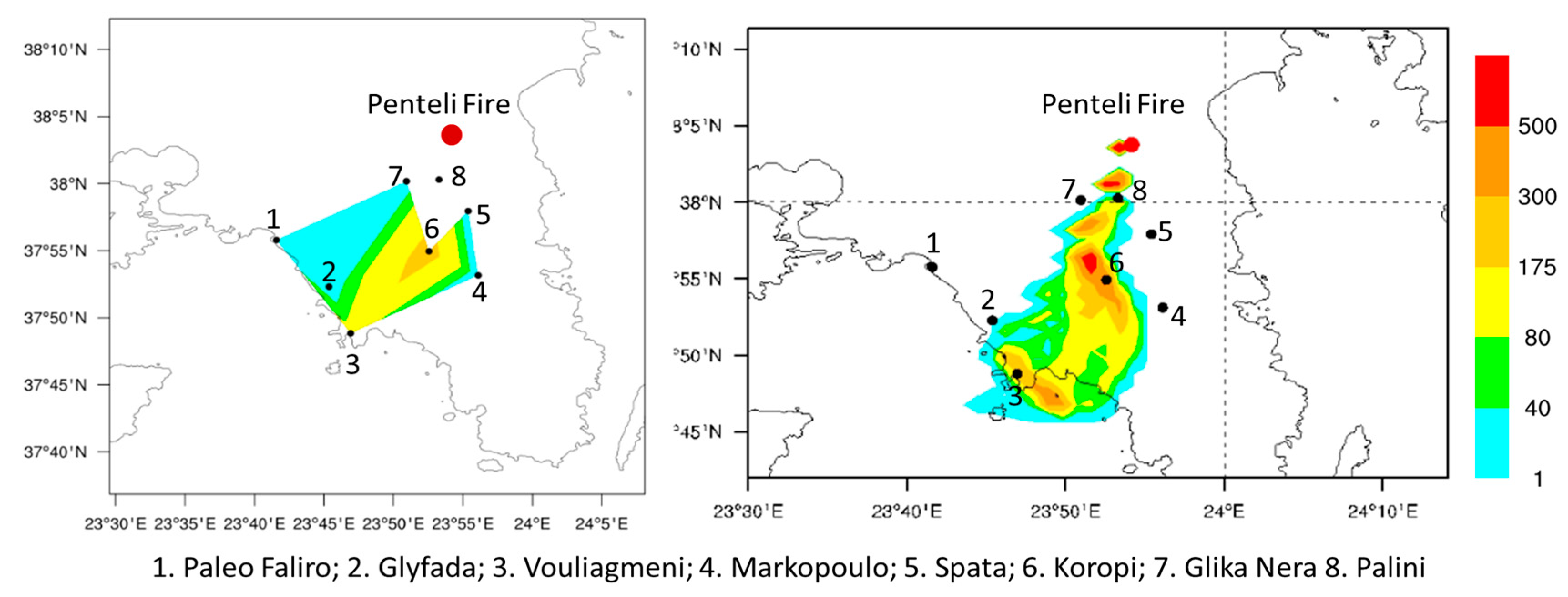
Figure 1). For all the above settlements, a precautionary evacuation order was issued through the 112 application, with police officers assisting in the evacuation operations of residents.
According to the Fire Service, 600 evacuations to a safe place were carried out by police forces and a total of 5 evacuation messages were sent via 112. Specifically, the messages were sent at 02.00 (LT) for the area of Penteli and around the 414 military hospital, at 02.50 (LT) for the eastern areas of Gerakas, at 04.30 (LT) for Voula Pikermi and Panorama of Pallini, at 05.20 (LT) for Pallini and Nea Pallini, and at 06.05 (LT) instructions were sent through 112 to avoid moving on Marathonos Avenue, from Attiki Odos junction to Pikermi, due to the fire in the area. The two fronts entered the residential areas of Drafi, Penteli, Anthousa, Anthousa, Dioni, Dasamari, Palea Penteli, Gerakas, Voula Pikermiou, Panorama of Pallini, Pallini, Nea Pallini, and the Pedon Hospital of Penteli, PIKPA, and found fertile ground for expansion and fuel from uncleared parts of the settlements, accumulated dead branches, and tall grasses. The “ring” of fire caused a large “mushrooming” of smoke, which made water drops difficult or impossible. Helicopters were operating between the houses and the scattered fire outbreaks, making targeted drops, but to no avail. At dawn, and while firefighters were battling on the ridge of Penteli and in the area of the children’s hospital, the fire changed direction. The flames moved again towards Drafi, Anthousa, reaching Pallini and Marathonos Avenue. In the morning hours of 20 July 2022, the fire was in suppression.
Regarding the reaction of the state mechanism to the Penteli fire, a full picture is given of the preparations that were made and of the operation to suppress the large fire. Specifically, it is first emphasized that a Fire Risk Forecast Map had been issued the previous day (July 18), according to which Attica was in category 4 (very high risk of fire). At the beginning of the incident (17:19 L.T.), the activation of the fire brigade was immediate. In total, this included 485 firefighters, with 28 hand crews teams and 120 fire engines. Furthermore, 28 Romanian firefighters were also involved, while the mobile operational center of the Fire Service’s “OLYMPOS” was also deployed on the ground. In total, 26 air assets were operated, including 16 aircraft and 10 helicopters. At their maximum deployment, 19 air assets were operating simultaneously. In addition, the total area affected by the fire that broke out on July 19 in Penteli and spread to areas of eastern Attica amounted to 2781.7 hectares. These figures were extracted from a survey carried out by the European Union’s Copernicus/Emergency Management Service-Mapping service.
The smoke from the Penteli fire was transferred southwards by the prevailing north winds (
Figure 2) and, as seen in the METEOSAT-11 satellite images, the smoke plume extended at least 400 km south–southwest, towards the sea of Kythera and the Cretan Sea. The dispersion of smoke particles along with the air-quality measurements are described in the following sections.
3. Smoke Dispersion
The dispersion of smoke from the Penteli wildfire is described based on air-quality measurements from the National Observatory of Athens stations network, atmospheric modeling with FireHub FLEXPART-WRF system, METEOSAT-11 satellite observations, and lidar remote sensing at the Antikythera PANGEA station.
3.1. Air-Quality Measurements
The Atmospheric Physics and Chemistry Group (APCG) in NOA use sensors and Internet of things (IoT) technologies, aiming to provide reliable real-time information for citizens, to support air quality management authorities in decision making, and improve characterization of personal exposure to ambient pollution and its determining factors. As one of the services provided by the YPATIA, the operational unit of NOA, the APCG has installed a network of over 25 low-cost PM2.5 optical monitors (PurpleAir PA-II) in residential locations in the Greater Athens Area.
Athens International Airport (AIA) continuously monitors air quality and meteorological conditions, both within the Airport fence and in the adjacent communities. In addition, emissions of air pollutants from all relevant airport sources are assessed, while measures are taken to reduce these emissions where possible. AIA’s monitoring equipment includes an air quality monitoring network (AQMN), which consists of five permanent monitoring stations installed in the neighboring areas of Glyka Nera, Koropi, Markopoulo, Pallini, and Spata.
As seen in
Figure 3, on 19 July during the initial stages of the fire, the concentration of PM
2.5 particles reached 54.5 μg m
−3 at Pallini station at 15:00 UTC and 68.5 μg m
−3 at Vouliagmeni station at 17:00 UTC. These stations are located about 7 km and 30 km downwind of the fire front, respectively. The air quality measurements during the evening and night hours indicate a further increase in particle concentration, namely 57 μg m
−3 at Pallini at 21:00 UTC, 19 July, 120 μg m
−3 at Vouliagmeni (01:00 UTC, 20 July 2022) and 221.5 μg m
−3 at Koropi at 04:00 UTC, 20 July 2022.
3.2. Dispersion Modeling
The spatiotemporal evolution of smoke dispersion was described using the FLEXPART-WRF FireHub platform [
2,
3]. The WRF model was configured with four grids, as shown in
Figure 4. The external domain had a 13.5 × 13.5 km grid space, and the two-way nested domains used a 4.5 × 4.5 km, 1.5 × 1.5 km, and 500 × 500 m grid space analysis. Such high-resolution atmospheric modeling was required in order to resolve the fine scale motions of the air masses that governed the smoke dispersion over the complex Attica terrain.
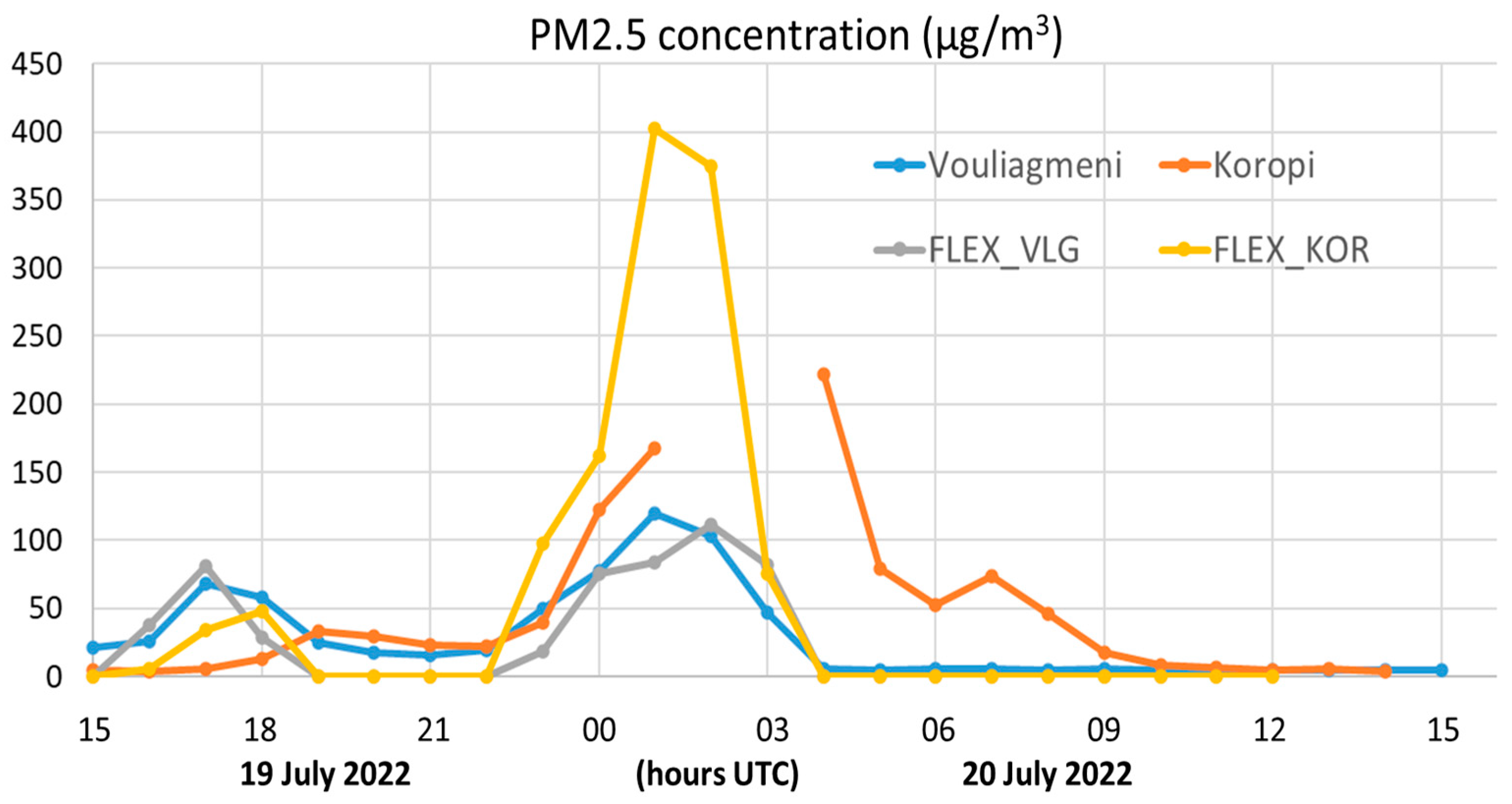
The dispersion of the PM
2.5 particles from the fire emissions was resolved with a FLEXPART model that was offline, coupled with the WRF output fields. As seen in
Figure 5, the simulation reproduced the two distinctive peaks as measured at the two most affected stations of Vouliagmeni and Koropi. The simulated PM
2.5 concentrations at Vouliagmeni are in good agreement with the corresponding measurements (about 50 μg m
−3 on 19 July and 100 μg m
−3 on 20 July). The modeled concentrations at Koropi are in good agreement with the station measurements for the 19th of July. The severe peak on 20th July was also reproduced in the model, reaching up to 402.68 and 374.57 μg m
−3 at 01:00 UTC and 02:00 UTC, respectively. However, the station measurements were disrupted at 02:00 UTC and 03:00 UTC, and it was not possible to determine if such high concentrations were actually detected at this station. The spatial distribution of smoke was characterized by a relatively narrow and very directional plume towards the SSW (
Figure 6), which explains why most urban areas remained unaffected by the fire smoke. The vertical extent of the plume was constrained by the planetary boundary layer (PBL) inversion at about 1.7 km. Such a deep PBL favors the long range transport of smoke from coastal areas when the continental air mass slips above the shallower marine layer [
3]. The modeled PM
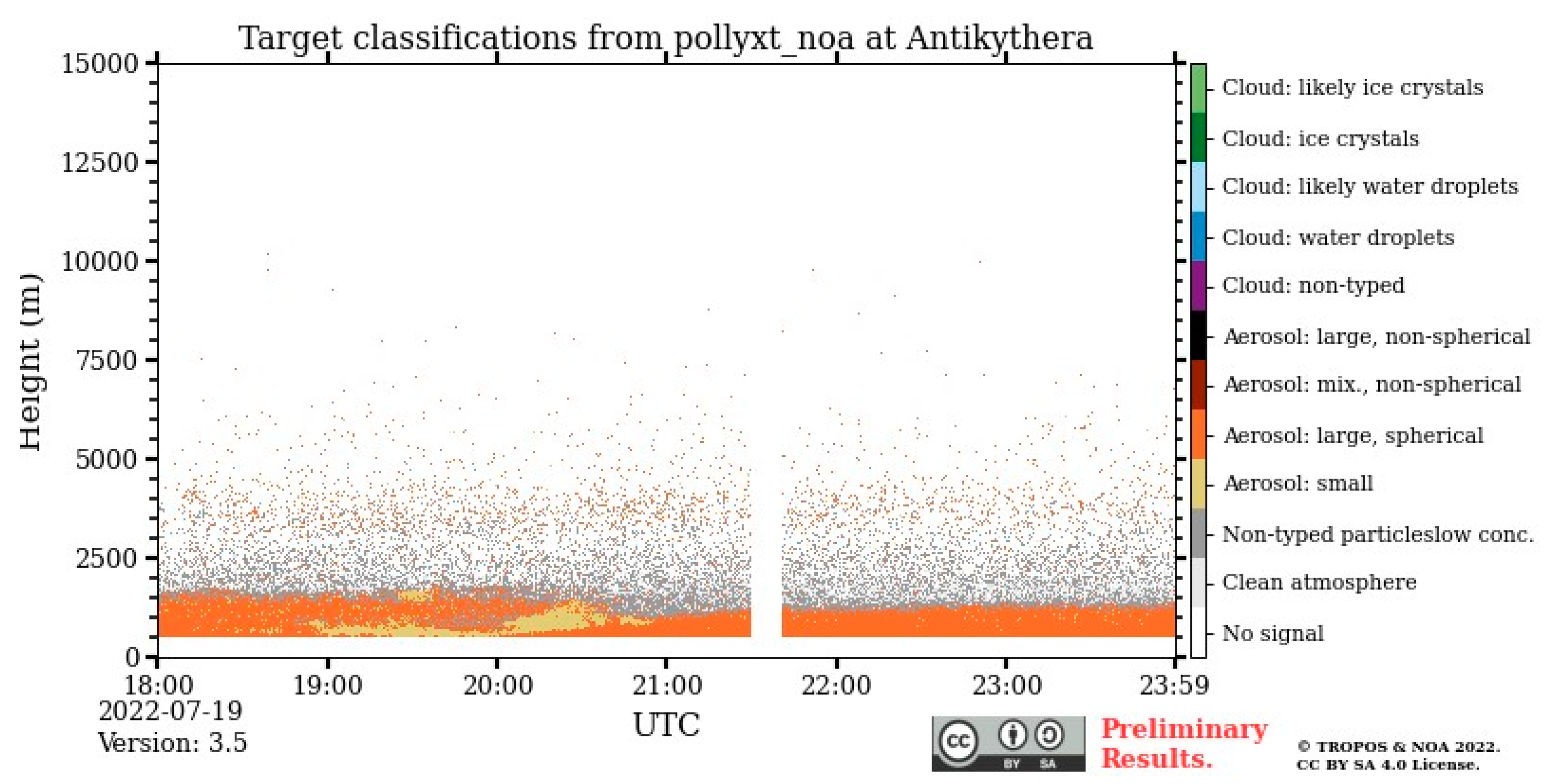
2.5 smoke plume extended from the firespot towards the Aegean and reached the Antikythera PANGEA station in the evening hours of 19 July 2022, as seen in
Figure 7. The biomass burning particles from the Penteli fire were detected at the lidar station at heights 0.5–2 km and are indicated as Aerosol Small type in
Figure 8.
4. Recommendations and Actions at Strategical, Tactical, and Operational Levels
The smoke produced by forest fires is particularly harmful to people’s health, even affecting those who are not close to the fire front. Examining the forest fire in Penteli and the measurements of gases and particles from measuring stations near the fire, one notices that the concentrations of PM10 and PM2.5 (air pollutants particularly harmful to human life and the environment) were almost four times higher the day after the fire, on 20 July.
Due to very strong winds, the smoke from the fire moved quite directionally and affected a narrow area of Attica. Indeed, the stations of Paleo Faliro, Glyfada and Glykon Neron did not measure an increase in pollutants and the concentrations of PM10 and PM2.5 were low. In contrast, the stations of Koropi and Vouliagmeni, which were on the line of the smoke path, measured a large increase in pollutants, above the alert thresholds (unhealthy category according to Public Health Officials). The positive thing was that, due to the strong winds, the smoke moved quickly and did not remain stationary in a particular area. This is evidenced by the fact that the maximum PM10 and PM2.5 concentrations did not last long. The negative was that, due to the low atmospheric inversion, the smoke moved at low altitudes and affected residential areas with high concentrations. In areas close to the fire, e.g., Penteli, the PM2.5 concentrations during the 24 h period may have reached 400 or 500 micrograms per cubic meter, as the FLEXPART model calculated. This air pollution was not concentrated in the Penteli area but spread over a very long distance. It was detected in Antikythera, as measured by the PANGEA station. One protection measure would be to remove the population from the areas where a forest fire has occurred, as happened. Close to the fire front one is in immediate danger from the smoke, but the health burden is also very high. The evacuations were not only because the fire could have been directed there but also for reasons of health protection against the smoke.
Author Contributions
Conceptualization, N.I. and S.S.; methodology, N.I. and S.S.; software, S.S.; validation, N.I., M.C., S.S., C.K., V.A., K.E., N.M., E.G. and C.Z.; resources, S.S., C.K. and V.A.; writing—original draft preparation, N.I. and S.S.; writing—review and editing, N.I., M.C., S.S., C.K., N.B., A.M., V.A., E.M., K.E., N.M., E.G. and C.Z.; visualization, S.S. and E.M. All authors have read and agreed to the published version of the manuscript.
Funding
This research received no external funding.
Institutional Review Board Statement
Not applicable.
Informed Consent Statement
Not applicable.
Data Availability Statement
All data are available upon request.
Acknowledgments
I would like to thank the Search and Rescue project for financially supporting the registration of the COMECAP 2023 conference.
Conflicts of Interest
The authors declare no conflict of interest.
References
- Lipsett, M.; Materna, B.; Stone, L.S.; Therriault, S.; Blaisdell, R.; Cook, J. Wildfire Smoke: A Guide for Public Health Officials. California Air Resources Board. 2008. Available online: https://www.phoenixvis.net/PDF/wfgv8.pdf (accessed on 22 April 2023).
- Brioude, J.; Arnold, D.; Stohl, A.; Cassiani, M.; Morton, D.; Seibert, P.; Angevine, W.; Evan, S.; Dingwell, A.; Fast, J.D.; et al. The Lagrangian particle dispersion model FLEXPART-WRF version 3.1. Geosci. Model Dev. 2013, 6, 1889–1904. [Google Scholar] [CrossRef]
- Solomos, S.; Amiridis, V.; Zanis, P.; Gerasopoulos, E.; Sofiou, F.I.; Herekakis, T.; Brioude, J.; Stohl, A.; Kahn, R.A.; Kontoes, C. Smoke dispersion modeling over complex terrain using high resolution meteorological data and satellite observations—The FireHub platform. Atmos. Environ. 2015, 119, 348–361. [Google Scholar] [CrossRef]
| Disclaimer/Publisher’s Note: The statements, opinions and data contained in all publications are solely those of the individual author(s) and contributor(s) and not of MDPI and/or the editor(s). MDPI and/or the editor(s) disclaim responsibility for any injury to people or property resulting from any ideas, methods, instructions or products referred to in the content. |
© 2023 by the authors. Licensee MDPI, Basel, Switzerland. This article is an open access article distributed under the terms and conditions of the Creative Commons Attribution (CC BY) license (https://creativecommons.org/licenses/by/4.0/).


 ,
, 


