Proceeding Paper

Meteorological Parameters in Homer’s Odyssey 

1
Department of Physics, School of Science, University of Thessaly, 35133 Lamia, Greece
2
Research Centre for Atmospheric Physics and Climatology, Academy of Athens, 11521 Athens, Greece
Presented at the 16th International Conference on Meteorology, Climatology and Atmospheric Physics—COMECAP 2023, Athens, Greece, 25–29 September 2023.
Environ. Sci. Proc. 2023, 26(1), 177; https://doi.org/10.3390/environsciproc2023026177
Published: 6 September 2023

Abstract

:
Although Homer’s Odyssey is not a scientific or historical work, it reveals certain elements of Meteorology. Weather phenomena during Ulysses’ 10-year return journey reflect empirical observations from the Bronze Age up to the post-Mycenaean era, or even the early Geometric times, probably localized across the Mediterranean Sea. Seeking descriptive characteristics or other features in the Odyssey’s narration, this study is an attempt to build up a scientific approach in several items, e.g., wind fields considering related tests for comparison.

1. Introduction

Together with the versatile and well-travelled Odysseus, we will get to know the weather phenomena as described in the Homeric epic the Odyssey from the Bronze Age up to the middle of the eighth century B.C., when the first written record of the Homeric epics was made. Homer does not make a scientific record, but in a poetic way he incorporates in his descriptions with extreme precision experiences and observations as they were accumulated in his time from the knowledge of the then-known world. Philological criticism of the text reveals neither specific times nor exact locations and details of Odysseus’ ten-year return journey to his homeland.

2. Materials and Methods

The sources for this study were: (a) Homer’s Odyssey, original text in ancient Greek and translation in modern Greek poetry form by N. Kazantzakis and I. Kakridis, in order to select narrative descriptions of meteorological phenomena [1]; (b) Mapzen Global Terrain [2] and ESRI National Geographic USA Topo Map [3], used to create Odysseus’ 10-year journey in the Mediterranean Sea; (c) the Earth’s axial precession theory for the orientation in Homer’s era in order to develop a wind rose diagram; (d) the Beaufort wind force scale for the corresponding wind velocity; and (e) Global Digital Elevation Model images [4] for the depiction of Gape Maleas surroundings on the tenth day of Odysseus’ journey. Every verse rhapsody in the Odyssey is referred to Fitzgerald’s English translation [5] in the order of the Odyssey book and verse assigned by Arabic numbers, e.g., (Od. 5, 296). Winds are depicted by arrows in certain locations, indicating their origin and speed in the Beaufort scale by their length. The map was developed via Quantum Geographic Information System software.

3. Results

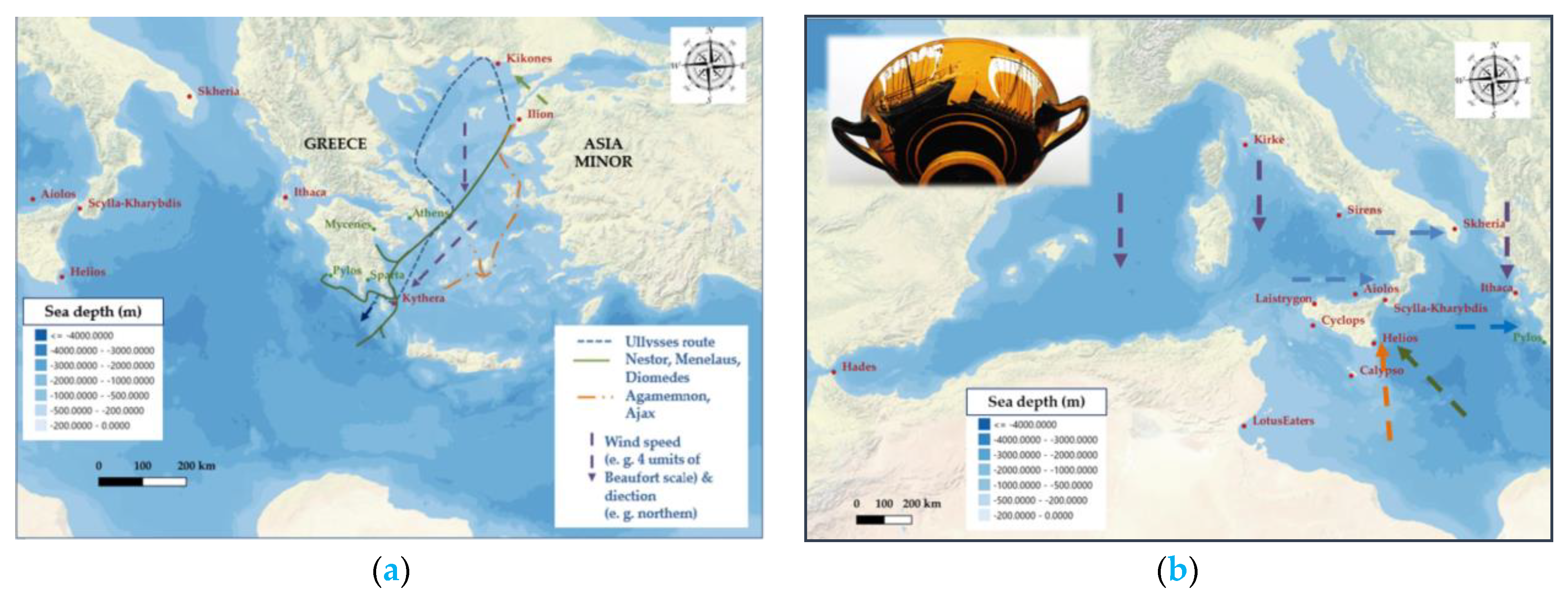
According to the prevailing approaches, Odysseus moves first to the Aegean archipelagos in the Eastern Mediterranean and then to the rest of the Mediterranean Sea, mainly in the area of southern Italy, and finally to the Ionian Sea.
After the fall of Troy, the Achaean fleet is divided and Odysseus with his ships follows a different route. In early summer, he sails close to the coast of Greece with the help of the etesian (summer annual) winds. The etesian winds have a north-northeast direction and blow in the Aegean with great intensity, mainly in July and August. When he reaches the area of Cape Maleas and Kythera, a sudden storm occurs, possibly due to the impact of a cold front which moves eastward since the appearance of cyclonic systems is frequent in summer. Several Achaean ships are driven to the coast of Egypt, while Odysseus’ ships are forced to follow a western direction, unable to return to Ithaca. This extraordinary meteorological phenomenon could be also the case of a strong microburst, which cause strong straight-line winds [6]. Such a phenomenon can be on the scale of a few kilometers but has very serious effects on sailing ships in the open sea, since the wind speed can exceed 100 knots, i.e., 185 km per hour (Figure 1).
In the epics of Homer, as in the works of Hesiod, meteorological phenomena are personifications or activities of the gods. Zeus summons the clouds, sends the rain, causes the storms, delivers the lightning and creates the thunder. The winds are controlled by the gods, Zeus, Athena, Poseidon and the nymph Calypso, who in turn can raise waves, cause storms, eddies and other winds. On the other hand, of course, they can safely guide the ships on their course (Od. 5, 21; 14, 305; 12, 415; 9, 67; 5, 382–385; 5, 291–296; 10, 19). The control of the weather, then, has great symbolic importance, and Homer’s descriptions serve as references for later meteorological analyses [7].
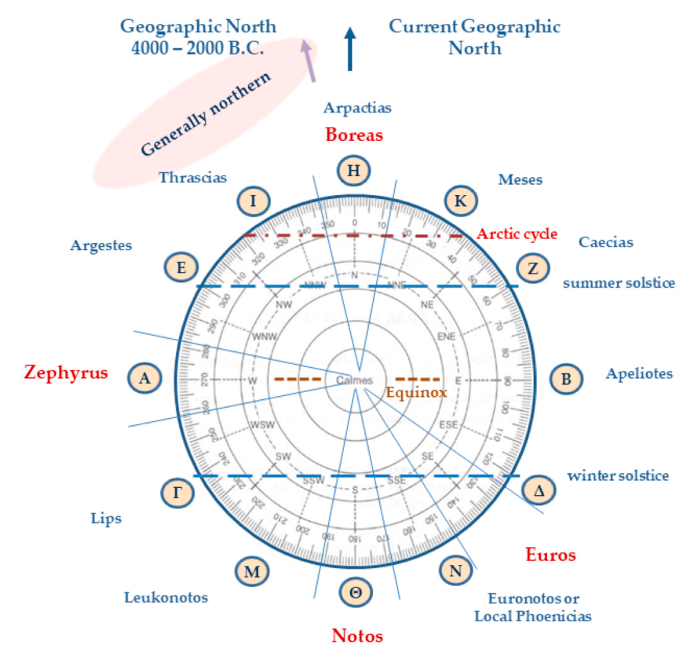
In Homer’s wind field conception, there are four main winds. It is Boreas, a particularly strong north wind, which blows from the Arctic North. The second is Notos (the south), a warm wind, in the opposite direction from the north. Zephyrus, also known as Ponentes, which blows from the west, appears as a fair wind but can also cause disasters. The last wind is named Euros, with a possible southeast or east direction, corresponding to Sirocco or the Levant. At this point, we must point out that at the time of the Homeric epics, the ancient Greeks placed the geographic north a little further west than its current orientation. That is, today the geographic north is located near the star ζ of Ursa Minor, which is also the polar star. It appears to be stationary, because all the other stars of the Northern Hemisphere appear to revolve around the North Pole in an east-to-west direction. At that time, there was no appropriate bright star to point to the north. Because Ursa Major, as Homer testifies (Od. 5, 301–303), was near the north pole of the celestial sphere, it revolved around itself and served as a marker for northward journeys. The ancient Greeks called the northern side of the horizon “arcton”. Thus, the winds that blow from the north are called northerly and that from the meridian southerly [8]. From 4000 to 2000 BC, the geographic or astronomical north was near the binary star α of the constellation Dragon, always seen in the Northern Hemisphere, which is 3.7 times fainter than the brightest star of this constellation, γ Draconis. The change in the position of the geographic north is related to the precession of the Earth’s rotation axis. The precession, with a period of about 25,800 Earth years, is mainly due to the gravitational force of the Sun and the Moon on the Earth’s equatorial bulge.
Homer’s wind rose was expanded by Aristotle and Timosthenes of Rhodes with winds of twelve directions (Figure 2), which correspond to respective circular sectors including the arctic circle, the line of the equinoxes and the solstices for the extreme points of sunrise and sunset at a location of latitude 40° N. The direction and intensity of the winds determine Odysseus’ journey by favoring or changing his course and ultimately causing his destruction. They are released from the bag of Aeolus when it is opened by the companions of Odysseus (Od. 10, 47).
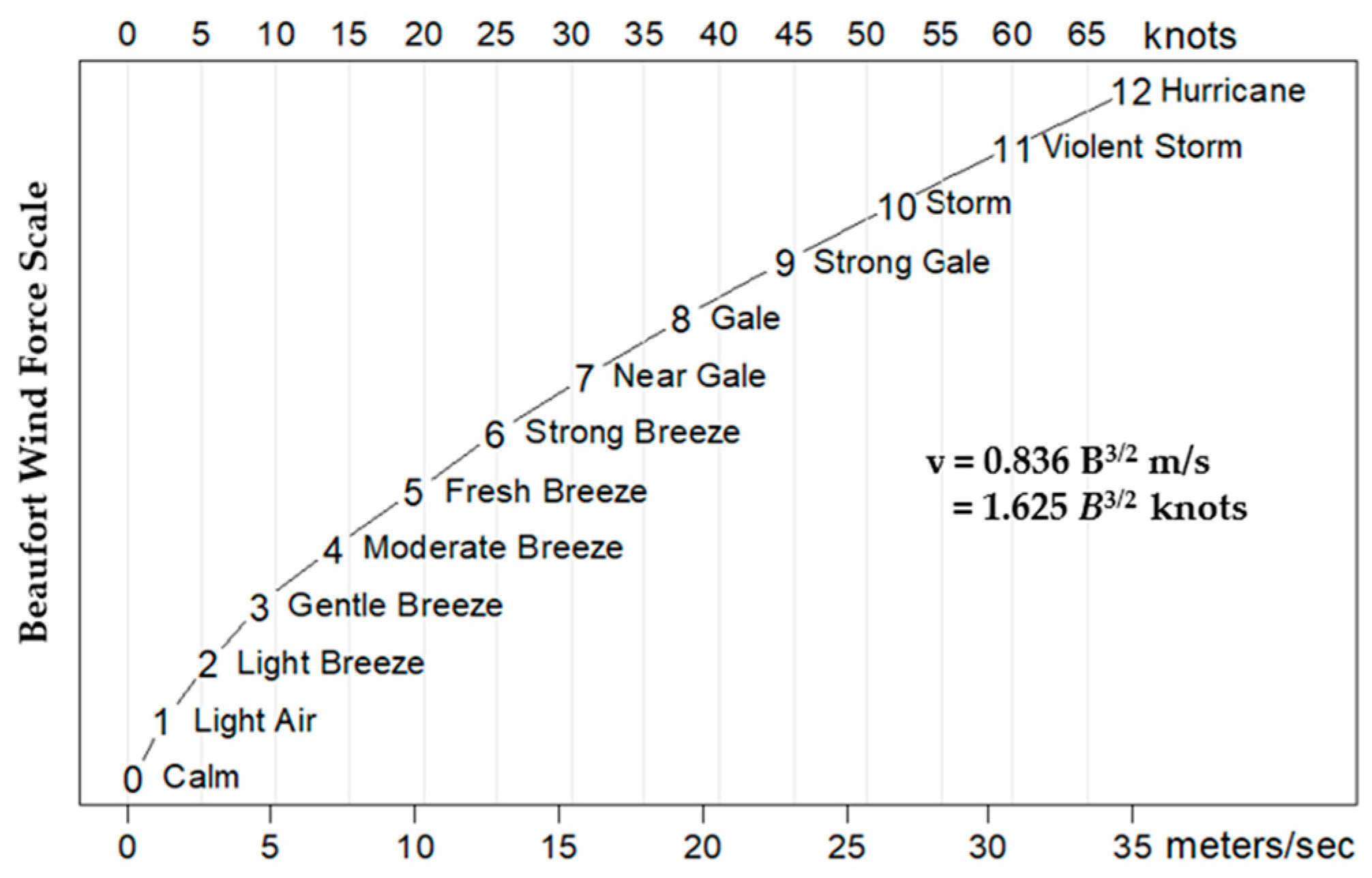
Their intensity, i.e., their speed, could be estimated via the empirical Beaufort scale according to the adjective verbal determination of the winds in the epic poem, e.g., breeze, fair, high, dashing, harsh, gale, stormy, hurricane, etc. (Figure 3). Considering the adjective determinations of the Odyssey’s winds’ intensity, we would estimate that these four winds can be strong (6 B) up to violently stormy (11 B), or even reach hurricane level (12 B), since the text mentions swirls and tornadoes. That is, their speed can range from 10 m per second (36 km per hour) to exceeding 30 m per second (110 km per hour).

4. Discussion

Other phenomena are mentioned in the Odyssey such as rain, rarely snow, fog, eddies, swirls, gales and storms. Homer does not make systematic climatology, but conveys the observations of his time sailing. Additionally, the ships of the Homeric times were very vulnerable to weather changes The depiction of the stations and routes of Odysseus’ journey on a map of the Mediterranean is based on the philological criticism of the texts and cannot be completely linked to meteorological or climatological phenomena. Nor, of course, can these phenomena be defined in specific periods of time in the ten-year return journey. In particular, Odysseus’ raft’s uncontrolled sailing (Od. 5, 295–310) may be related to a cyclonic low-pressure field or meteorological bomb since (a) all four dashing winds are blowing simultaneously and are mixing and (b) extensive heavily cloudiness and gale are present (Figure 4 a,b).

5. Conclusions

The four winds of the Odyssey may not have exactly opposite flows, but their relative intensity determines the meteorological phenomena. The zonal flow of westerly winds in the Northern Hemisphere justifies the appearance of the Zephyrus, just as the transport of cold air masses from the north corresponds to the Boreas. The south wind, Notos, could be characterized as a warm and moist wind due to its origin in Africa and its passage over the sea surface of the Mediterranean. Euros, as an easterly or south-easterly wind, can prevent sailing or even cause a great storm. This is also confirmed by other sources such as the Euroclydon wind, which was particularly threatening southward of Crete for the ship that carried Apostle Paul [10]. It seems that the geographical area of occurrence of the meteorological phenomena is the Aegean area, the Tyrrhenian Sea, the wider area of Sicily and Malta or even the coasts of today’s Tunisia, the area below the Straits of Otranto and the Ionian Sea. However, we have serious reservations because Homer is not a geographer and gives a literary rather than a strictly scientific interpretation of his hero’s action area.

Funding

This research received no external funding.

Institutional Review Board Statement

Not applicable.

Informed Consent Statement

Not applicable.

Data Availability Statement

Publicly available datasets were analyzed in this study. These data can be found in the references of Section 2 Materials and Methods of this study.

Conflicts of Interest

The author declares no conflict of interest.

References

  1. Kazantzakis, N.; Kakridis, I. Homer’s Odyssey; New Greek Studies Institution, Aristotle University of Thessaloniki: Thessaloniki, Greece, 2015; ISBN 978-960-231-166-0. (In Greek) [Google Scholar]
  2. Mapzen Global Terrain. Available online: https://mapscaping.com/adding-basemaps-in-qgis/ (accessed on 29 March 2023).
  3. ESRI National Geographic USA Topo Maps. Available online: http://services.arcgisonline.com/arcgis/rest/services/USA_Topo_Maps/MapServer/tile/{z}/{y}/{x}.png (accessed on 29 May 2023).
  4. Earth Data Search. Available online: https://asterweb.jpl.nasa.gov/data.asp (accessed on 31 May 2023).
  5. Google Docs. Available online: https://docs.google.com/viewer?a=v&pid=sites&srcid=Y2YuazEyLm1uLnVzfG1ycy13aW5nZXR8Z3g6MTQ2ZjJhMTA0N2FiOTM1MQ (accessed on 29 March 2023).
  6. Cerveny, R.S. Meteorological Assessment of Homer’s Odyssey1993. Bull. Am. Meteorol. Soc. 1993, 74, 1025–1034. [Google Scholar] [CrossRef]
  7. Taub, L. Ancient Meteorology (Translated in Greek); Enalios Editions: Athens, Greece, 2003; pp. 23–27. [Google Scholar]
  8. Aristotle. Hapanta, Vol 13, Meteorologica A, B (in Greek) Ancient Greek Literature, the Greek; Cactus Editions: Athens, Greece, 1994; p. 361a, 22. [Google Scholar]
  9. Kakridis, J. Odyssey Geography; Pro-Homeric, Homeric, Hesiodian; Bookstore of Estia: : Athens, Greece, 1980; pp. 92–108. [Google Scholar]
  10. The New Testament. Acts (27, 14); Apostoliki Diakonia of Church of Greece: Athens, Greece, 2014; p. 342. [Google Scholar]
Figure 1. Odysseus’ ships reaching Cape Maleas sailing by the coastline: “… but as I came round Malea the current took me out to (Mediterranean) sea, and from the north a fresh gale drove me on, past Kythera” (Od. 9, 80–81).
Environsciproc 26 00177 g001
Figure 2. A 12-wind rose (signed by Greek alphabet letters) in the Eastern Mediterranean based on Homer (8th cent. B.C.), Aristotle (4th cent. B.C.) and Timosthenes of Rhodes (3rd cent. B. C.). Only 4 winds are mentioned in the Odyssey: Boreas, Notos, Zephyrus and Eurus. Timosthenes added Leukonotos and Euronotos.
Environsciproc 26 00177 g002
Figure 3. The Beaufort wind force scale: an empirical measure relating wind speed to observed conditions at sea or on land.
Environsciproc 26 00177 g003
Figure 4. Ulysses’ return voyage: (a) Ulysses’ and Achaeans’ ships’ route in the Aegean Sea (current Bathymetry limits included) within 10 days after their departure from Troy in early summer of possibly 1218/1217 B.C., (b) stations in the Mediterranean Sea (1218/1217—1208/1207 B.C) according to philological criticism of Odyssey text [9] by I. Kakridis (current Bathymetry limits included). Homer’s era merchant vessel (holkas) depicted on black-figured pottery kylix (British Museum).
Environsciproc 26 00177 g004
Disclaimer/Publisher’s Note: The statements, opinions and data contained in all publications are solely those of the individual author(s) and contributor(s) and not of MDPI and/or the editor(s). MDPI and/or the editor(s) disclaim responsibility for any injury to people or property resulting from any ideas, methods, instructions or products referred to in the content.

