You are currently viewing a new version of our website. To view the old version click .
Environmental Sciences Proceedings
  • Please note that, as of 4 December 2024, Environmental Sciences Proceedings has been renamed to Environmental and Earth Sciences Proceedings and is now published here.
  • Proceeding Paper
  • Open Access

29 August 2023

Waterspout Outbreak Environments and Forecasting in Greece †

,
,
and
1
Hellenic National Agricultural Insurance Organization (ELGA), Meteorological Applications Center, Airport Macedonia, 57001 Thermi, Thessaloniki, Greece
2
International Centre for Waterspout Research, Toronto ON L1E 0EG, Canada
*
Author to whom correspondence should be addressed.
Presented at the 16th International Conference on Meteorology, Climatology and Atmospheric Physics—COMECAP 2023, Athens, Greece, 25–29 September 2023.
This article belongs to the Proceedings 16th International Conference on Meteorology, Climatology and Atmospheric Physics—COMECAP 2023

Abstract

Waterspout outbreaks are very impressive phenomena defined as multiple waterspouts successively forming in a specific area. This study presents the twelve largest waterspout outbreak cases that have occurred in the last two decades (2000–May 2023) in Greece. Synoptic data indicated a closed low (CLOSED) pattern prevailed during waterspout outbreaks over the Aegean and Ionian Seas. A variety of convective parameters were examined, including most unstable CAPE (MUCAPE), mixed-layer lifting condensation level (MLLCL), low-layer shear (LLS) and 0–1 storm-relative helicity (SRH). The Szilagyi Waterspout Index (SWI) is applied successfully and is suggested for further consideration and application in waterspout operational forecasting.

1. Introduction

Waterspouts are tornadoes over the water surface of a sea or lake and develop as intense columnar vortices [,]. Waterspout wind speeds typically reach 55–85 knots (F0 on the Fujita scale), with much stronger winds for waterspouts associated with supercell thunderstorms that can pose a threat to boats, shipping, recreational water activities and to people and infrastructures [,,]. Waterspout outbreaks are impressive phenomena defined as multiple waterspouts forming in a specific area. Hagemeyer defined waterspout outbreaks on the Florida peninsula, USA, as multiple waterspouts of four or more [].
Sioutas et al. [] defined waterspout outbreaks as multiple successive waterspout occurrences on a single calendar day, 00:00 through 23:59 UTC, and generally produced by the same weather system. The International Centre for Waterspout Research (ICWR) has been conducting research on waterspouts from around the world as part of their Global Waterspout Mapping Project []. The European Severe Weather Database (ESWD) is a source of severe weather data, including waterspouts, over Europe []. Also, active tornado waterspout research over the last years for the Mediterranean has been developed, focusing on meteorological conditions, outbreaks and forecasting [,,,,,].
The studied areas of the Ionian and Aegean Seas are characterized by irregular coastlines combined with numerous small and larger islands. These geographic configurations can often create low-level differential heating and local wind convergence, which tends to initiate waterspout occurrences [,,,]. In this study, the twelve greatest waterspout outbreak cases occurred in the Greek Seas over the last two decades (2000–May 2023) with 10 or more individual waterspouts observed are investigated and their synoptic and mesoscale environments and a forecasting method are presented.

2. Materials and Methods

The largest waterspout outbreaks occurred in the Greek Seas within the period 2000–2023 (until May 2023) and included 10 or more individual waterspouts, constituted a total of 12 cases in the Greek tornado database []. As seen in Figure 1a and in Table 1, it is interesting to note that 9 out of the 12 cases occurred in southern Greece, north offshore of Crete Isl. and northeastern offshore of Rhodes Isl. In Figure 1b, a snapshot is displayed of 3 simultaneous waterspouts of a total of 11 waterspouts that occurred during the 1 January 2021 outbreak in Rhodes Isl., Greece.
Figure 1. (a) Largest waterspout outbreak locations in the 23-year period 2000–May 2023. (b) Waterspout outbreak in Rhodes Isl. on 1 January 2021 (photo by Stavros Kesedakis).
Table 1. Waterspout outbreak dates and locations in Greece in the 23-year period 2000–May 2023.
A number of 9 out of the total 12 cases occurred over southern Greece: 6 in the Cretan Sea and 3 in the northeast offshore of Rhodes Isl. Of the remaining 3 cases, 2 occurred in Kerkyra (Corfu) Isl. and 1 in Skopelos Isl. Regarding monthly occurrences, 4 cases occurred in January, 3 in September, 2 in December and 1 in each of February, June and October. Regarding time of the day, the vast majority, 9 out of 12 cases occurred in the morning hours 04:00–10:00 UTC, 2 at noon 14:00–15:34 UTC and 1 in the evening 21:00–22:00 UTC. In Table 1, a list of the waterspout outbreaks with geographical locations, day and time of occurrence is provided.
Synoptic patterns leading to waterspout formation were identified and classified according to a four-synoptic-type scheme, namely: southwest flow (SW), shortwave trough (SWT), closed low (CLOSED) and longwave trough (LW). This classification is based on the 500 hPa level and the position of trough and ridge axes in conjunction with surface features []. Synoptic maps were extracted using the NOAA-Global Data Assimilation System (last accessed May 2023). Radiosonde data close in space and time to waterspout outbreaks, preferably upwind to the outbreak location, were gathered by the University of Wyoming (www.uwyo.edu, accessed on 30 May 2023). The data were analyzed using the SHARPpy program [] and the thermodynamic, dynamic, wind parameters and instability indices were extracted.

3. Results

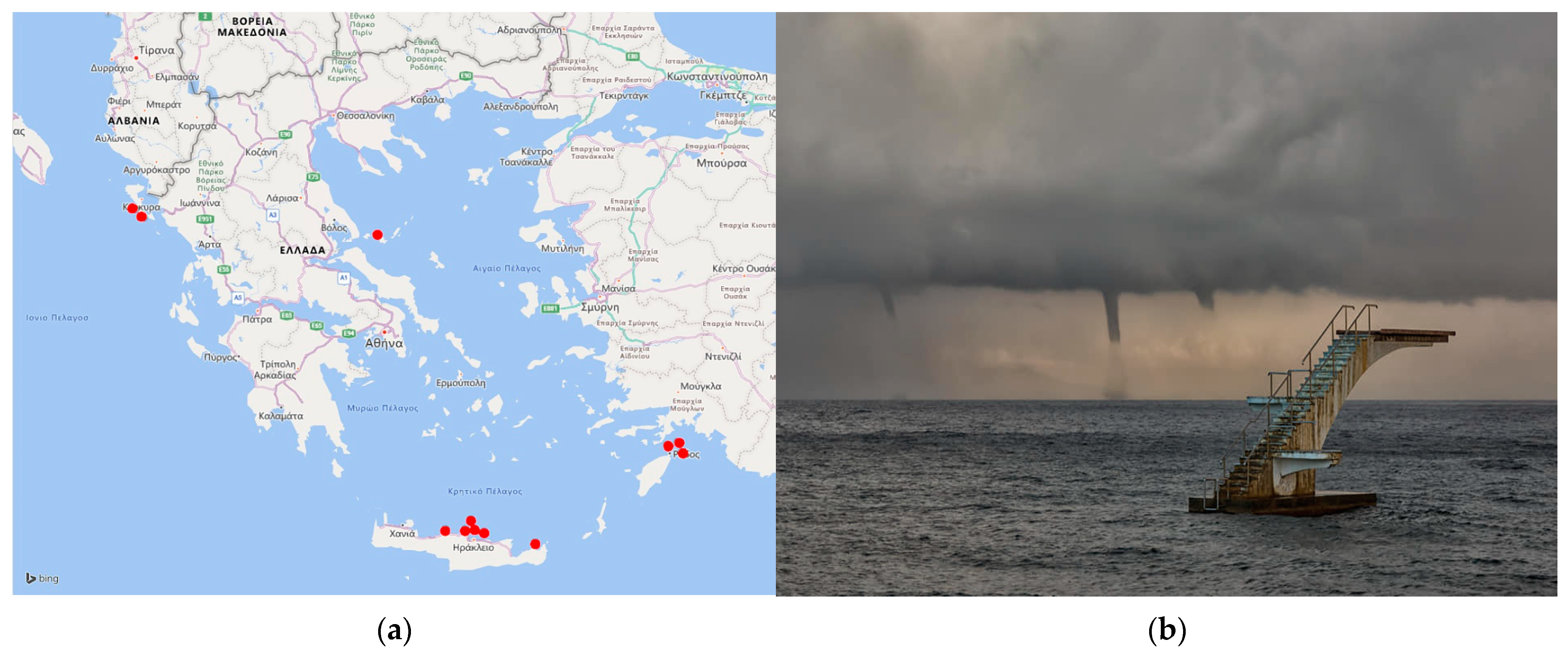
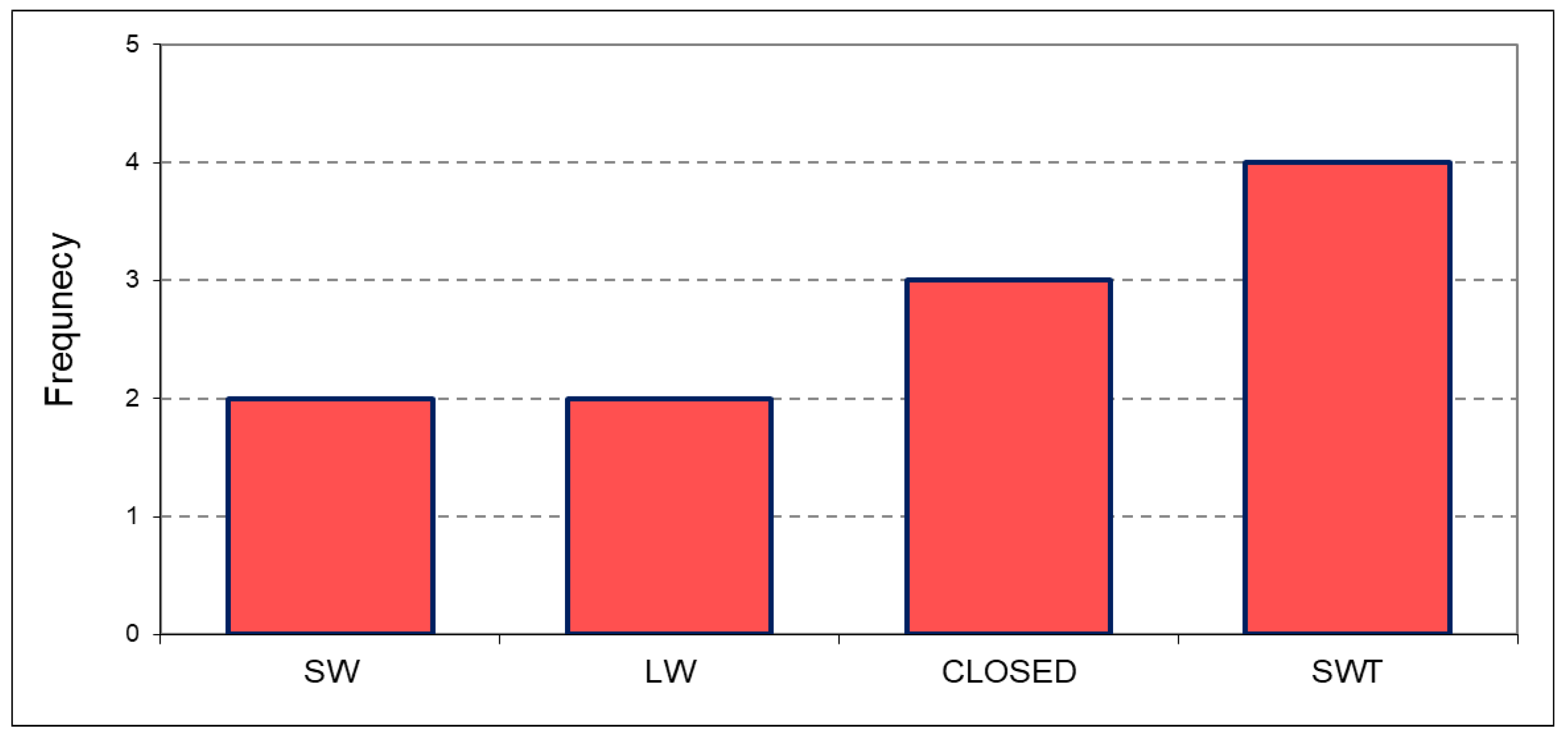
3.1. Synoptic Types on Waterspout Outbreak Days

Waterspouts occur during specific synoptic patterns that have been identified and categorized in various research focusing on common and dominant characteristics and targeting the improvement of analysis and increasing of forecast skills [,]. According to the four-synoptic-type scheme described in the previous session, the examined sample of waterspout outbreak cases mostly occurred on days with prevailing conditions of SWT and CLOSED types, followed by LW and SW types (Figure 2).
Figure 2. Synoptic pattern types on waterspout outbreak days in Greece (2000–May 2023).

3.2. Mesoscale Environment

A total of 15 thermodynamic, wind parameters and instability indices based on radiosonde data are examined and presented in Table 2. Mean values of most parameters indicated a weak to moderate unstable environment for waterspout outbreaks. MUCAPE, defining the vertically integrated positive buoyancy of an adiabatically rising parcel, was averaged at 274 J/kg, with MLLCL averaged at 699 m, indicative of a thunderstorm potential with a small likelihood for tornado occurrence [,,].
Table 2. Thermodynamic, wind parameters and instability indices for large waterspout outbreak environments in Greece.
Conventional instability indices were also indicative of a weak to moderate unstable environment. A steep temperature-lapse rate between the water surface and lowest atmospheric layers, along with positive buoyancy, proved to be a primary factor for waterspout outbreak occurrences.

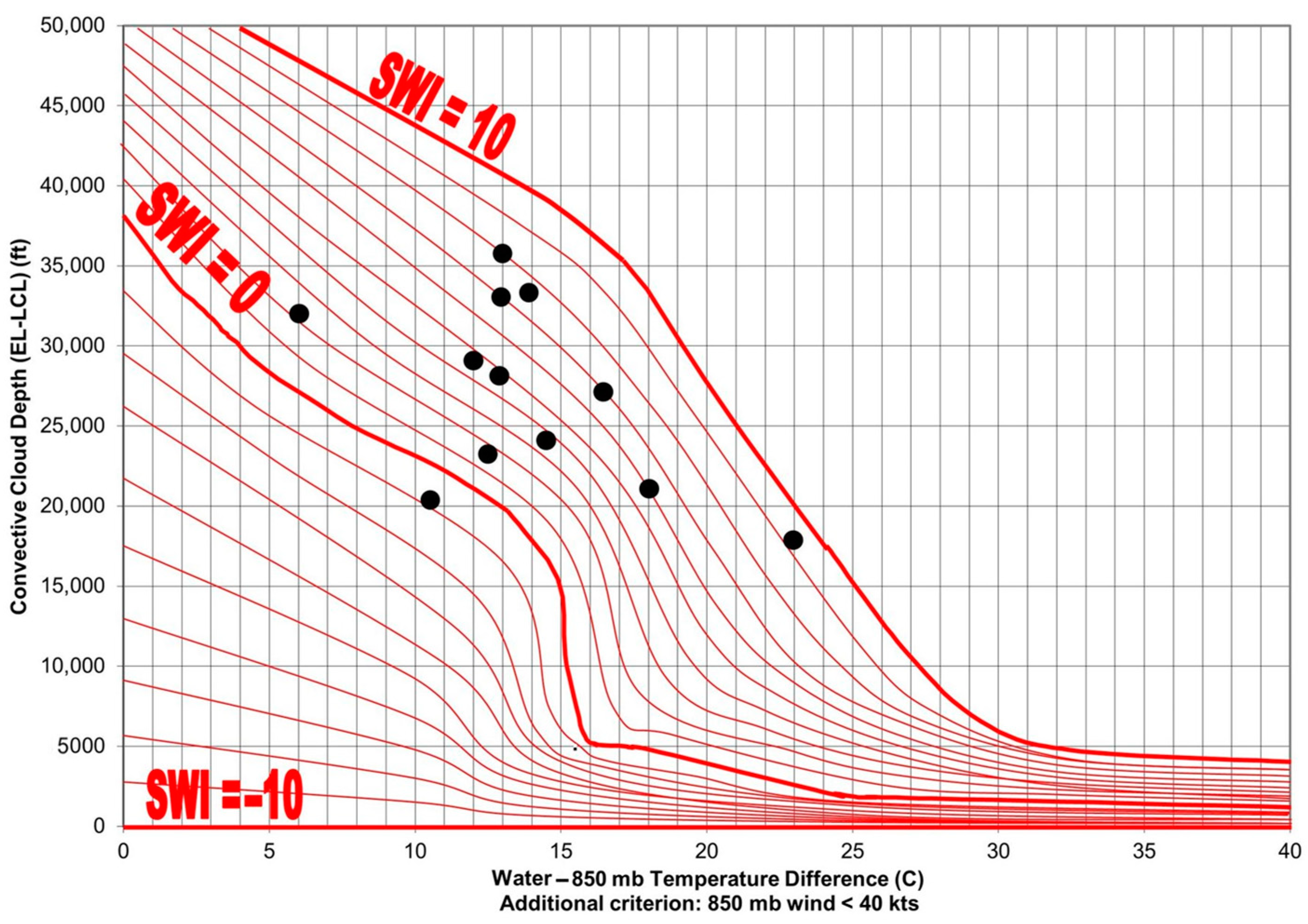
3.3. Waterspout Forecasting—The Szilagyi Waterspout Index (SWI)

The SWI has been developed to determine the potential for waterspout development. It is based on the Szilagyi Waterspout Nomogram (SWN). It uses a data set of over 1000 waterspout events that occurred over the Great Lakes of North America from 1994 to the present (May 2023). The SWN and SWI have been tested with success in other temperate regions such as the Mediterranean Sea and the Adriatic Sea [,,].
The method is based on three parameters which are strongly correlated with waterspout events: surface water−850 mb temperature difference ∆T, convective cloud depth ∆Z = EL − LCL and 850 mb wind speed. The values of the SWI ranged from −10 to +10, with waterspouts most likely to occur when SWI ≥ 0. The larger the value of SWI, the higher the potential for waterspout development.
SWI values for the examined waterspout outbreak cases were determined by using the nearest upper air sounding data to the outbreak event, and then the airmass was modified over the sea surface; the results are given in Table 3. As illustrated on the Szilagyi Waterspout Nomogram (Figure 3), there is a strong correlation between waterspout outbreaks for SWI values of ≥0 with all waterspout cases of the study, except one. Also, most waterspout outbreaks were associated with moderate convection, likely thunderstorms, with rather moderate convective cloud depth. During the winter season, outbreaks were associated with shallower convection and higher water −850 mb temperature difference values.
Table 3. Waterspout outbreak forecasting data using the Szilagyi Waterspout Index (SWI).
Figure 3. Large waterspout outbreaks in Greece: sea surface water-850 mb temperature difference, convective cloud depth and dots represent Szilagyi Waterspout Index (SWI) values.

4. Summary and Conclusions

The greatest waterspout outbreak cases recorded in the Greek Seas during the 23-year period of 2000–May 2023 were examined in terms of synoptic, mesoscale and thermodynamic environments and forecasting. Sea surface temperatures with the superimposed atmospheric airmass lapse rates play a fundamental role in waterspout occurrence. The analysis showed fundamental synoptic and mesoscale thermodynamic elements that can create a supportive environment even with limited instability and weak to moderate wind shear magnitudes. Climatic localities and geographical features can play a significant role in concentrating multiple waterspout occurrences.
The data sample examined indicated most thermodynamic parameters, including CAPE, LLS and 0–1 km storm-relative helicity, indicated low likelihood of tornadoes based on the threshold values in the literature. The probability for waterspout occurrence seems maximized in weak vertical wind shear and steep low-level lapse rates. The parameter WMAXSHEAR, representing the square root of 2 CAPE (WMAX) and DLS having a mean value of 359 m2/s2, seems a good indicator for the assessment of convective phenomena, including waterspouts.
Regarding waterspout predictability based on the SWI method, the majority of outbreaks examined were strongly correlated with SWI values ≥ 0, with values ranging from −1 to 8. Combined with knowledge of waterspout climatology and local climatic backgrounds, the Szilagyi Waterspout Index (SWI) can be a very useful tool and is suggested for further testing and operational application in waterspout forecasting.

Author Contributions

Conceptualization, M.V.S.; methodology, M.V.S. and W.M.S.; writing—review and editing, M.V.S., W.M.S., M.M.C. and E.A.C.; All authors have read and agreed to the published version of the manuscript.

Funding

This research received no external funding.

Institutional Review Board Statement

Not applicable.

Data Availability Statement

Not applicable.

Acknowledgments

The authors would like to thank all waterspout observers, meteorologists, amateurs, sailors, the ICWR (International Centre for Waterspout Research) and the ESWD (European Severe Weather Database), with special thanks to Stavros Kesedakis, Ioannis Gasteratos, Michalis Dretakis, George Alaxandrakis, Costas Kritsalos and Spiros Mitsoulis for their waterspout outbreak reports. Acknowledgements are also expressed to ELGA (Hellenic National Agricultural Insurance Organization).

Conflicts of Interest

The authors declare no conflict of interest.

References

  1. Gordon, A.H. Waterspouts. Weather 1951, 6, 364–371. [Google Scholar] [CrossRef]
  2. Kanellopoulos, H. The waterspout of 1st September 1973 in Corfu. Bull. Greek Meteorol. Soc. 1977, 3, 41–50. (In Greek) [Google Scholar]
  3. Golden, J.H. An assessment of waterspout frequencies along the U.S. East and Gulf Coasts. J. Appl. Meteorol. 1977, 16, 231–236. [Google Scholar] [CrossRef]
  4. Fujita, T.T. Tornadoes and downbursts in the context of generalized planetary scales. J. Atmos. Sci. 1981, 38, 1511–1534. [Google Scholar] [CrossRef]
  5. Sioutas, M.V. A tornado and waterspout climatology for Greece. Atmos. Res. 2011, 100, 344–356. [Google Scholar] [CrossRef]
  6. Hagemeyer, B.C. Peninsula Florida tornado outbreaks. Weather Forecast. 1997, 12, 399–427. [Google Scholar] [CrossRef]
  7. Sioutas, M.; Szilagyi, W.; Keul, A. Waterspout outbreaks over areas of Europe and North America: Environment and Predictability. Atmos. Res. 2013, 123, 167–179. [Google Scholar] [CrossRef]
  8. Sioutas, M.; Szilagyi, W.; Keul, A. The International Centre for Waterspout Research. In Proceedings of the 5th European Conference on Severe Storms, Landshut, Germany, 12–16 October 2009; pp. 319–320. [Google Scholar]
  9. Dotzek, N.; Groenemeijer, P.; Feurestein, B.; Holzer, A.M. Overview of ESSL’s severe convective storms research using the European Severe Weather Database ESWD. Atmos. Res. 2009, 93, 575–586. [Google Scholar] [CrossRef]
  10. Sioutas, M.V.; Keul, A.G. Waterspouts of the Adriatic, Ionian and Aegean Sea and their meteorological environment. Atmos. Res. 2007, 83, 542–557. [Google Scholar] [CrossRef]
  11. Renko, T.; Kuzmić, J.; Šoljan, V.; Strelec Mahović, N. Waterspouts in the Eastern Adriatic from 2001 to 2013. Nat. Hazards 2016, 82, 441–470. [Google Scholar] [CrossRef]
  12. Homar, V.; Gaya, M.; Ramis, C. A synoptic and mesoscale diagnosis of a tornado outbreak in Balearic Islands. Atmos. Res. 2001, 56, 31–55. [Google Scholar] [CrossRef]
  13. Sioutas, M.; Dafis, S.; Papavasileiou, G.; Doe, R. An updated tornado climatology and associated meteorological environments in Greece. In Proceedings of the 11th European Conference on Severe Storms, Bucharest, Romania, 8–12 May 2023. [Google Scholar]
  14. Keul, A.G.; Sioutas, M.V.; Szilagyi, W. Prognosis of Central-Eastern Mediterranean waterspouts. Atmos. Res. 2009, 93, 426–436. [Google Scholar] [CrossRef]
  15. Renko, T.; Kozarić, T.; Tudor, M. An assessment of waterspout occurrence in the Eastern Adriatic basin in 2010: Synoptic and mesoscale environment and forecasting methods. Atmos. Res. 2013, 83, 71–81. [Google Scholar] [CrossRef]
  16. Matsangouras, I.T.; Nastos, P.T.; Pytharoulis, I. Numerical Investigation of the Role of Topography in Tornado Events in Greece. In Advances in Meteorology, Climatology and Atmospheric Physics; Helmis, C.G., Nastos, P.T., Eds.; Springer: Berlin/Heidelberg, Germany, 2012; pp. 209–215. [Google Scholar] [CrossRef]
  17. Matsangouras, I.T.; Nastos, P.T.; Bluestein, H.B.; Sioutas, M.V. A climatology of tornadic activity over Greece based on historical records. Int. J. Climatol. 2014, 34, 2538–2555. [Google Scholar] [CrossRef]
  18. Blumberg, W.G.; Halbert, K.T.; Supinie, T.A.; Marsh, P.T.; Thompson, R.L.; Hart, J.A. SHARPpy: An Open-Source Sounding Analysis Toolkit for the Atmospheric Sciences. Bull. Am. Meteorol. Soc. 2017, 98, 1625–1636. [Google Scholar] [CrossRef]
  19. Taszarek, M.; Brooks, H.E.; Czernecki, B. Sounding-derived parameters associated with convective hazards in Europe. Mon. Weather Rev. 2017, 145, 1511–1528. [Google Scholar] [CrossRef]
  20. Púcik, T.; Groenemeijer, P.; Rýva, D.; Kolár, M. Proximity soundings of severe and nonsevere thunderstorms in central Europe. Mon. Weather Rev. 2015, 143, 4805–4821. [Google Scholar] [CrossRef]
  21. Grieser, J.; Haines, P. Tornado Risk Climatology in Europe. Atmosphere 2020, 11, 768. [Google Scholar] [CrossRef]
Disclaimer/Publisher’s Note: The statements, opinions and data contained in all publications are solely those of the individual author(s) and contributor(s) and not of MDPI and/or the editor(s). MDPI and/or the editor(s) disclaim responsibility for any injury to people or property resulting from any ideas, methods, instructions or products referred to in the content.

Article Metrics

Citations

Article Access Statistics

Multiple requests from the same IP address are counted as one view.