Abstract
Precipitation is a key component of the hydrological cycle and directly affects water availability and hydrometeorological hazards. The objective of this study is to evaluate the performance of two reanalysis precipitation datasets, ERA5 and ERA5-land, in reproducing precipitation accumulations over Greece. These data are compared against rainfall measurements provided by the dense network of surface-automated weather stations operated by the National Observatory of Athens. The comparisons are performed over a 10-year period (January 2010 to December 2020) at multiple temporal and spatial scales. Several statistical metrics are used to assess the performance of the reanalysis precipitation against rain gauge observations. The suitability of gridded products is tested by capturing the temporal and spatial variability in precipitation using accuracy metrics.
1. Introduction
Reliable and accurate precipitation information is essential for water resources and ecosystem management [1,2,3]. However, there are different data sources to obtain precipitation time-series: (i) ground observations, (ii) satellite estimates, and (iii) numerical simulations [4].
The rain gauge is the most widely used and reliable method for the direct measurement of precipitation at the point scale [5]. Nevertheless, the distribution and density of rain gauge networks vary significantly across the Greek territory, with relatively dense or no observations near shore or mountainous areas, make it challenging to offer continuous precipitation information. Satellite and reanalysis gridded data represent a valuable source of information specifically in regions with sparse data, but as they are derived from indirect precipitation measurements and simulations, errors can be important and may vary significantly among different regions or seasons [6].
This study aims to investigate the suitability of the two gridded precipitation products in reproducing the precipitation accumulations over Greece by comparing them over a 10-year period (January 2010 to December 2020) at multiple temporal and spatial scales. Several statistical metrics are used to assess the performance of the reanalysis precipitation estimates against rain gauge observations.
2. Material and Methods
2.1. Study Area
Greece, situated in southeastern Europe on the Balkan Peninsula, is a member of the European Union with 27 member countries. The varied topography of Greece, characterized by steep elevation changes and an extensive coastline spanning approximately 14,000 km, contributes to the diversity of rainfall patterns and climate in various regions across the country. More specifically, the precipitation patterns exhibit great seasonality, with the rainy season prevailing during the autumn, winter, and early spring, while the dry season dominates throughout the summer months [7,8]. The Pindus Mountain range, stretching across the country in a northwest to southwest direction, plays a significant role in shaping the spatial distribution of rainfall values. The western part of continental Greece and Crete experience the highest amount of rainfall, while the eastern regions, including the Aegean islands and eastern Crete, receive lower levels of precipitation.
2.2. Observational and Gridded Data
This study was conducted in the Greek territory by comparing the temporal and spatial changes (2010–2020) between rain gauge observations and grid points of two reanalysis rainfall datasets: ERA5 and ERA5-land. Rain gauge data were obtained from the National Observatory of Athens (NOA) [9], which operates and maintains a dense network of surface-automated weather stations in Greece (Figure 1). The dataset included monthly average observed precipitation from 135 gauges located across the Greek territory from 1 January 2010 to 31 December 2020.
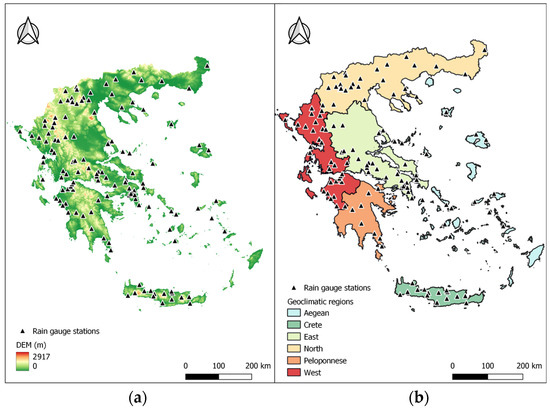
Figure 1.
Location map of the study area. (a) Topography and the location of the selected weather stations over Greece. (b) Geo-climatic zones, as defined in a recent study [10], using multi-year average precipitation from bias-corrected gauge data.
As for the gridded reanalysis rainfall products, the ERA5 and ERA5-Land reanalysis data were selected to be evaluated and compared against rainfall measurements provided by NOA. ERA5 is the fifth generation of atmospheric reanalysis to be produced by the European Centre for Medium-Range Weather Forecasts (ECMWF) and covers the period from 1950 to present with a grid resolution of 31 km [11]. ERA5-land is produced as an enhanced global dataset for the land component of the fifth generation of ERA5 and describes the evolution of the water and energy cycles over land in a consistent manner over the production period [12].
The validation of the gridded products was performed for the 10-year period at a monthly temporal scale. The precipitation data obtained from each gauge were directly compared to the nearest grid point value in each reanalysis product. To assess the accuracy and error attributes of the gridded reanalysis datasets, a selection of statistical metrics was selected.
The correlation coefficient (CC) quantifies the strength of the linear relationship between the gridded estimated precipitation and the observed precipitation from rain gauges [13]. The mean bias error (MBE) provides an average measure of the difference between the estimated and observed precipitation, and it is used to measure the over- and under-estimation in data products. The mean absolute error (MAE) represents the average magnitude of the absolute errors, providing an overall measure of error magnitude. It measures accuracy for continuous variables without considering the direction of the error. The relative bias (RBIAS) indicates the systematic bias between the estimated and observed precipitation. The root-mean-square error (RMSE) represents the average magnitude of the errors between the estimated and observed precipitation, without indicating the direction of deviations.
The statistical metrics were calculated using Equations (1)–(5).
where is the value of the gridded reanalysis precipitation data for the i-th monthly event, is the value of the rain gauge observation for the i-th monthly event, and and are the average values of estimated and observed precipitations of N average monthly observations for the period 2010 to 2020, respectively.
3. Results and Discussion
Table 1 shows the performance of ERA5 and ERA5-land products at a monthly time scale. The ERA5 product yields a slightly higher correlation with rain gauge observations compared to ERA5-land, while the correlation coefficient (CC) is 0.61 and 0.51 for ERA5 and ERA5-land, respectively. In most gauges, both datasets overestimate monthly rainfall with an average MBE of 1.80 and 1.52 for the 10-year period, respectively. Regarding the RMSE values, there is a slight difference between the two products, with ERA5 demonstrating slightly better results.

Table 1.
Average values of statistical metrics for the gridded rainfall data for the period 2010–2020.
Based on the data presented in Table 2, the correlation coefficient (CC) values range from 0.49 to 0.71, indicating a moderate to strong correlation between the modeled and observed rainfall. The highest CC values are generally observed in spring for both datasets. In winter and autumn, both datasets tend to overestimate precipitation, while they show a better accuracy with negative MBE values in spring and summer. ERA5-land consistently shows lower MAE and RMSE values across all seasons compared to ERA5, indicating better estimation and more precise rainfall estimates. The RBIAS values are close to zero, suggesting minimal systematic bias between the two datasets.
Table 2.
Average values of statistical metrics for gridded rainfall data for each season over Greece for the period 2010–2020.
During the 10-year period, ERA5 consistently displays higher values of RMSE compared to ERA5-land across all geoclimatic regions. ERA5-land generally shows lower values for MBE, MAE, and RMSE compared to ERA5. This means that ERA5-land presents a better agreement with the observed data in terms of bias (MBE), absolute errors (MAE), and RMSE. More specifically, the RMSE of ERA5 in the Crete region has the largest error value of 47.95 mm, indicating the high magnitude of the differences between the observed and modeled values. In the west region, both datasets exhibit moderate correlations (CC = 0.60) with the rain observations. However, they present a positive bias, indicating a low overestimation of values. Similar findings are observed in the southwestern region of Peloponnese, where both datasets have a moderate correlation (CC = 0.60). ERA5 shows a higher positive bias (MBE = 5.68 mm), indicating a higher overestimation compared to ERA5-land. The MAE and RMSE values are lower for ERA5-land, suggesting improved accuracy.
As Table 3 shows, similar to the Crete and east regions, the correlation is relatively moderate for both datasets. Concerning the Aegean region, the correlation is relatively high for both products, while they exhibit negative bias, indicating an underestimation of values. The same results are presented for both products in the north region.
Table 3.
Summary of statistical metrics for gridded rainfall data for each geoclimatic region of Greece.
Overall, the data show variations in performance metrics across different geoclimatic regions and between the ERA5 and ERA5-land datasets. ERA5-land generally demonstrates better accuracy and lower biases compared to ERA5. However, both datasets exhibit deviations from the observed data, with some regions showing larger discrepancies than others.
4. Conclusions
Gridded climate datasets are widely used in weather and climate research due to the high spatial and temporal resolution in comparison to the rain gauge observations. This study evaluates the performance of two reanalysis datasets in reproducing spatiotemporal characteristics of accumulated precipitation measured at 135 rain gauge stations at six geoclimatic regions in Greece during 2010–2020. The findings indicate that the performance of ERA5 and ERA5-land varies across the regions in Greece. Generally, ERA5-land exhibits higher accuracy and lower biases when compared to ERA5. Further analysis and understanding of the specific variables and their impacts on the different geoclimatic regions would be necessary for a more comprehensive interpretation.
Author Contributions
Conceptualization, S.S., S.D. and V.A.; methodology, S.S. and V.A.; software, V.A. and S.D.; formal analysis, S.S., S.D. and V.A.; investigation, S.S. and S.D.; writing—original draft preparation, V.A. and S.S.; writing—review and editing, S.S., S.D. and V.A.; visualization, V.A.; supervision, S.S., S.D. and V.A. All authors have read and agreed to the published version of the manuscript.
Funding
This research received no external funding.
Institutional Review Board Statement
Not applicable.
Informed Consent Statement
Not applicable.
Data Availability Statement
Not applicable.
Conflicts of Interest
The authors declare no conflict of interest.
References
- Zambrano, F.; Wardlow, B.; Tadesse, T.; Lillo-Saavedra, M.; Lagos, O. Evaluating satellite-derived long-term historical precipitation datasets for drought monitoring in Chile. Atmos. Res. 2017, 186, 26–42. [Google Scholar] [CrossRef]
- Huang, X.; Luo, G.; Chen, C.; Peng, J.; Zhang, C.; Zhou, H.; Yao, B.; Ma, Z.; Xi, X. How precipitation and grazing influence the ecological functions of drought-prone grasslands on the northern slopes of the Tianshan Mountains, China? J. Arid Land 2021, 13, 88–97. [Google Scholar] [CrossRef]
- Sheffield, J.; Wood, E.F.; Pan, M.; Beck, H.; Coccia, G.; Serrat-Capdevila, A.; Verbist, K. Satellite remote sensing for water resources management: Potential for supporting sustainable development in data-poor regions. Water Resour. Res. 2018, 54, 9724–9758. [Google Scholar] [CrossRef]
- Tapiador, F.J.; Turk, F.J.; Petersen, W.; Hou, A.Y.; García-Ortega, E.; Machado, L.A.; Angelis, C.F.; Salio, P.; Kidd, C.; Huffman, G.J.; et al. Global precipitation measurement: Methods, datasets and applications. Atmos. Res. 2012, 104, 70–97. [Google Scholar] [CrossRef]
- Lanza, L.G.; Stagi, L. Certified accuracy of rainfall data as a standard requirement in scientific investigations. Adv. Geosci. 2008, 16, 43–48. [Google Scholar] [CrossRef]
- Xie, W.; Yi, S.; Leng, C.; Xia, D.; Li, M.; Zhong, Z.; Ye, J. The evaluation of IMERG and ERA5-Land daily precipitation over China with considering the influence of gauge data bias. Sci. Rep. 2022, 12, 8085. [Google Scholar] [CrossRef]
- Livada, I.; Charalambous, G.; Assimakopoulos, M.N. Spatial and temporal study of precipitation characteristics over Greece. Theor. Appl. Climatol. 2008, 93, 45–55. [Google Scholar] [CrossRef]
- Markonis, Y.; Batelis, S.C.; Dimakos, Y.; Moschou, E.; Koutsoyiannis, D. Temporal and spatial variability of rainfall over Greece. Theor. Appl. Climatol. 2017, 130, 217–232. [Google Scholar] [CrossRef]
- Lagouvardos, K.; Kotroni, V.; Bezes, A.; Koletsis, I.; Kopania, T.; Lykoudis, S.; Mazarakis, N.; Papagiannaki, K.; Vougioukas, S. The automatic weather stations NOANN network of the National Observatory of Athens: Operation and database. Geosci. Data J. 2017, 4, 4–16. [Google Scholar] [CrossRef]
- Kazamias, A.P.; Sapountzis, M.; Lagouvardos, K. Evaluation of GPM-IMERG rainfall estimates at multiple temporal and spatial scales over Greece. Atmos. Res. 2022, 269, 106014. [Google Scholar] [CrossRef]
- Hersbach, H.; Bell, B.; Berrisford, P.; Hirahara, S.; Horányi, A.; Muñoz-Sabater, J.; Thépaut, J.N. The ERA5 global reanalysis. Q. J. R. Meteorol. Soc. 2020, 146, 1999–2049. [Google Scholar] [CrossRef]
- Muñoz-Sabater, J.; Dutra, E.; Agustí-Panareda, A.; Albergel, C.; Arduini, G.; Balsamo, G.; Boussetta, S.; Choulga, M.; Harrigan, S.; Hersbach, H.; et al. ERA5-Land: A state-of-the-art global reanalysis dataset for land applications. Earth Syst. Sci. Data 2021, 13, 4349–4383. [Google Scholar] [CrossRef]
- Asuero, A.G.; Sayago, A.; González, A.G. The correlation coefficient: An overview. Crit. Rev. Anal. Chem. 2006, 36, 41–59. [Google Scholar] [CrossRef]
Disclaimer/Publisher’s Note: The statements, opinions and data contained in all publications are solely those of the individual author(s) and contributor(s) and not of MDPI and/or the editor(s). MDPI and/or the editor(s) disclaim responsibility for any injury to people or property resulting from any ideas, methods, instructions or products referred to in the content. |
© 2023 by the authors. Licensee MDPI, Basel, Switzerland. This article is an open access article distributed under the terms and conditions of the Creative Commons Attribution (CC BY) license (https://creativecommons.org/licenses/by/4.0/).