Next Article in Journal
The Karla Aquifer (Central Greece), an Agricultural Region under Intensive Environmental Pressure Due to Agricultural Activities
Previous Article in Journal
Variation in Water Quality in an Impacted Coastal Lagoon over the Last Decade (Küçükçekmece Lagoon, Turkey)
 
 
Please note that, as of 4 December 2024, Environmental Sciences Proceedings has been renamed to Environmental and Earth Sciences Proceedings and is now published here.
Proceeding Paper

Estimation of Remotely Sensed Actual Evapotranspiration in Water-Limited Mediterranean Agroecosystems for Monitoring Crop (cotton) Water Requirements †

by
Marios Spiliotopoulos
1,*,
Nicolas Alpanakis
1,
Georgios A. Tziatzios
1,
Ioannis Faraslis
2,
Pantelis Sidiropoulos
1,
Stavros Sakellariou
2,
George Karoutsos
3,
Nicolas R. Dalezios
1 and
Nicholas Dercas
4
1
Department of Civil Engineering, School of Engineering, University of Thessaly, 38221 Volos, Greece
2
Department of Environmental Sciences, University of Thessaly, Gaiopolis Campus, 41500 Larissa, Greece
3
General Aviation Applications “3D” S.A., 2 Skiathou str, 54646 Thessaloniki, Greece
4
Department of Natural Resources Development and Agricultural Engineering, Agricultural University of Athens; Iera Odos 75, 11855 Athens, Greece
*
Author to whom correspondence should be addressed.
Presented at the 7th International Electronic Conference on Water Sciences, 15–30 March 2023; Available online: https://ecws-7.sciforum.net.
Environ. Sci. Proc. 2023, 25(1), 9; https://doi.org/10.3390/ECWS-7-14200
Published: 14 March 2023
(This article belongs to the Proceedings of The 7th International Electronic Conference on Water Sciences)

Abstract

:
The role of effective irrigation management for optimal food production is well recognized and can be partially solved through the improvement of water use efficiency (WUE). To control the quantity of the water applied to actual crops, net irrigation water requirements (NIWR) are needed. The computation of NIWR is based on the estimation of crop water requirements (CWR) and soil water balance, where crop evapotranspiration (ETc) is the main component. Earth observation (EO) using remote sensing (RS) has already become an important tool for the quantification and the detection of spatial and temporal distributions and variability in several environmental variables at different scales. Remotely sensed models are currently considered to be suitable for crop water use estimation in the field and at regional scales.

1. Introduction

Currently, the most prevailing group of EO methodologies for the estimation of ETc is the Energy Balance (EB) algorithms, and more specifically, residual methods [1]. Remotely sensed EB algorithms convert satellite-sensed radiances into land surface characteristics, such as albedo, leaf area index, vegetation indices, surface roughness, surface emissivity and surface temperature, to estimate ET as a “residual” of the land surface Energy Balance equation [2,3]. The most recent EB models differ mainly in how Sensible Heat (H) is estimated [1]. These models include the Two-Source Model (TSM), where the Energy Balances of soil and vegetation are modeled separately, and then combined to estimate total LE, the Surface Energy Balance Algorithm for Land (SEBAL) and the Mapping Evapotranspiration with Internalized Calibration (METRIC), which use hot and cold pixels within the satellite images to develop an empirical temperature difference equation, and the Surface Energy Balance Index (SEBI) based on the contrast between wet and dry areas [4,5,6]. Other variations in SEBI include the Simplified Surface Energy Balance Index (S-SEBI) and the Surface Energy Balance System (SEBS) [7].
In this paper, an actual daily evapotranspiration (ETa) computation methodology is presented as a contribution to a European-funded research project named “HubIS”. Obtaining useful spatial information and describing difficult physical processes through remote sensing is important for developing better agricultural practices. The applied approach was first operated by the European Space Agency (ESA) using the Sen-ET plug-in, and the proposed methodology is an improvement of ESA’s method. The proposed methodology framework consists of seventeen separate steps, with the outcome being the actual daily evapotranspiration flows estimation at a 20 × 20 m spatial resolution. The proposed methodology is applied to cotton in Thessaly, Greece, for the 2021 growing season. The results are very satisfactory and indicate the suitability of Sen-ET SNAP software to estimate daily actual evapotranspiration, as well as spatial variability throughout the crop. The methodology can be applied for effective irrigation management in data-scarce rural regions.

2. Materials and Methods—Study Area

In this study, a combination of Sentinel-2 and Sentinel-3 images for daily crop evapotranspiration estimation is presented and applied to cotton fields in Thessaly, Greece, which is considered to be a water-limited, Mediterranean, agricultural area. The simulation program used is the Sen-ET SNAP software. The plug-in uses satellite images from Sentinel-2 and Sentinel-3 and meteorological data from the Weather Research and Forecast (WRF) model. The purpose of the Sen-ET SNAP plug-in is to enable the estimation of daily actual evapotranspiration rates (and other land–surface energy fluxes) at the field scale.
The initial version of Sen-ET used in SNAP, developed by ESA, uses the two-source Energy Balance (TSEB) model [8] with Sentinel-2, Sentinel-3 and meteorological data from ECMWF (ESA, 2020) [9,10]. The adopted methodology in the present approach follows the initial 17 steps based on the TSEB model (Table 1). However, a modification of the initial Sen-ET SNAP used in the present study takes advantage of meteorological data taken from the WRF model, instead of ECMWF. This approach stands as a modification and improvement from the original plug-in. Real-time data produced by the WRF are inserted into the proposed methodology, finally giving ETa values in mm/day with a spatial resolution of 20 m × 20 m.
The study area is the region of Thessaly, which is the most cultivated region in Greece, (Figure 1). The annual quantity of water consumption is about 1.422 hm3, with 92%, i.e., approximately 1305.5 hm3, being used to meet the irrigation needs. Almost 500,000 ha are cultivated in Thessaly, while almost 250,000 are irrigated. Seventy-six (76) % of irrigation amounts comes from groundwater systems through legal or illegal drilling, while only twenty-four (24) % comes from surface water systems [9]. The physical condition of groundwater systems in Thessaly is not satisfactory both in quantitative and quality terms [9]. In the present study, seven experimental plots were used in the research program “HubIS” and were analyzed and processed.

3. Results

Figure 2 shows the variations in actual daily ETa values for cotton during the irrigation period when images from Sentinel-2 and Sentinel-3 were available.
Figure 3 shows the spatial distribution of the actual daily ETa values for the cultivation of cotton in the growing season when images from Sentinel-2 and Sentinel-3 were available. The plots are divided into “traditional” (farmer practices) and “experimental” (Hubis practices) areas. No other explanations are needed for the current study because more results between these plots are expected in future implementation of the program. The daily ETa values (farmer practices) range from 0 mm (recorded in February) to a maximum of 10 mm (recorded in early August). Figure depicts only a part of the available image dates due to width issues. Additionally, Figure 3 presents the spatial variation in the daily ETa values for the cultivation of cotton (Hubis practices) for the entire period that satellite images were available. The daily ETa values range from min 0 mm (recorded in February 2021) to a max of 9.5 mm at the beginning of August 2021.

4. Summary

In this study, a methodology developed by the University of Thessaly, Greece, is used for the calculation of actual evapotranspiration values using Sentinel imagery. This methodology suggests a modification and improvement of the initial ESA’s SEN-ET methodology. The SEN_ET methodology is supported by SNAP software utilizing Sentinel-2 and Sentinel-3 satellite imagery, as well as meteorological data from the Weather Forecast and Research (WRF) model, to estimate daily ETa values. The results of the experiment showed that there is a clear overestimation of ETa in some periods, especially during July and August. At the next step of the method’s improvement, it is important to use in-situ measurements.

Author Contributions

Conceptualization, N.A., G.A.T. and I.F.; methodology, I.F.; software, N.A. and G.A.T.; validation, M.S., S.S. and P.S.; formal analysis, P.S.; investigation, G.K.; resources, G.K.; data curation, G.K.; writing—original draft preparation, M.S. and N.A.; writing—review and editing, M.S.; visualization, N.R.D. and N.D.; supervision, N.R.D. and N.D.; project administration, S.S. and N.R.D.; funding acquisition, N.R.D. and N.D. All authors have read and agreed to the published version of the manuscript.

Funding

This research was funded by the project HubIS under the PRIMA 2019 program of the European Commission (HORIZON EUROPE).

Institutional Review Board Statement

Not applicable.

Informed Consent Statement

Not applicable.

Data Availability Statement

Not applicable.

Acknowledgments

The authors acknowledge the European Space Agency for the supporting data and materials.

Conflicts of Interest

The authors declare no conflict of interest.

References

  1. Gowda, P.H.; Chávez, J.L.; Howell, T.A.; Marek, T.H.; New, L.L. Surface Energy Balance Based Evapotranspiration Mapping in the Texas High Plains. Sensors 2008, 8, 5186–5201. [Google Scholar] [CrossRef]
  2. Bastiaanssen, G.M.W. SEBAL-based sensible and latent heat fluxes in the irrigated GedizBasin, Turkey. J. Hydrol. 2000, 229, 87–100. [Google Scholar] [CrossRef]
  3. Calera, A.; Campos, I.; Osann, A.; D’Urso, G.; Menenti, M. Remote Sensing for Crop Water Management: From ET Modelling to Services for the End Users. Sensors 2017, 17, 1104. [Google Scholar] [CrossRef]
  4. Bastiaanssen, W.G.M.; Menenti, M.; Feddes, R.A.; Holtslag, A.A.M. A remote sensing surface energy balance algorithm for land (SEBAL) 1. Formulation. J. Hydrol. 1998, 212, 198–212. [Google Scholar] [CrossRef]
  5. Bastiaanssen, W.G.M.; Pelgrum, H.; Wang, J.; Ma, Y.; Moreno, J.; Roerink, G.J.; van der Wal, T. The Surface Energy Balance Algorithm for Land (SEBAL): Part 2 validation. J. Hydrol. 1998, 212–213, 213–229. [Google Scholar] [CrossRef]
  6. Allen, R.; Tasumi, M.; Trezza, R. Satellite-Based Energy Balance for Mapping Evapotranspiration with Internalized Calibration (METRIC)-Model. J. Irrig. Drain. Eng. 2007, 133, 380–394. [Google Scholar] [CrossRef]
  7. Roerink, G.J.; Su, Z.; Menenti, M. S-SEBI: A simple remote sensing algorithm to estimate the surface energy balance. Phys. Chem. Earth Part B Hydrol. Ocean. Atmos. 2000, 25, 147–157. [Google Scholar] [CrossRef]
  8. Norman, J.M.; Kustas, W.P.; Humes, K.S. Source approach for estimating soil and vegetation energy fluxes in observations of directional radiometric surface temperature. Agric. For. Meteorol. 1995, 77, 263–293. [Google Scholar] [CrossRef]
  9. Ruescas, A.B.; Peters, M. S3TBX Collocation Tutorial, V1/rev6 1.0; ESA & Brockmann Consult GMBH. Available online: https://step.esa.int/docs/tutorials/Collocation_S3TBX_Tutorial_v1_rev6.pdf (accessed on 7 October 2022).
  10. Alpanakis, N.; Tziatzios, G.; Faraslis, I.; Spiliotopoulos, M.; Sidiropoulos, P.; Sakellariou, S.; Blanta, A.; Brisimis, V.; Dalezios, N.; Dercas, N. Modeling and Estimation of Actual Evapotranspiration in 3 Mediterranean agricultural areas in France, Greece, and Portugal by the aspect of the Sentinel 2 and 3 observations. In Proceedings of the 2nd AgroEcoInfo, Volos, Greece, 30 June–1 July 2022; ISBN 978-618-84403-8-8. [Google Scholar]
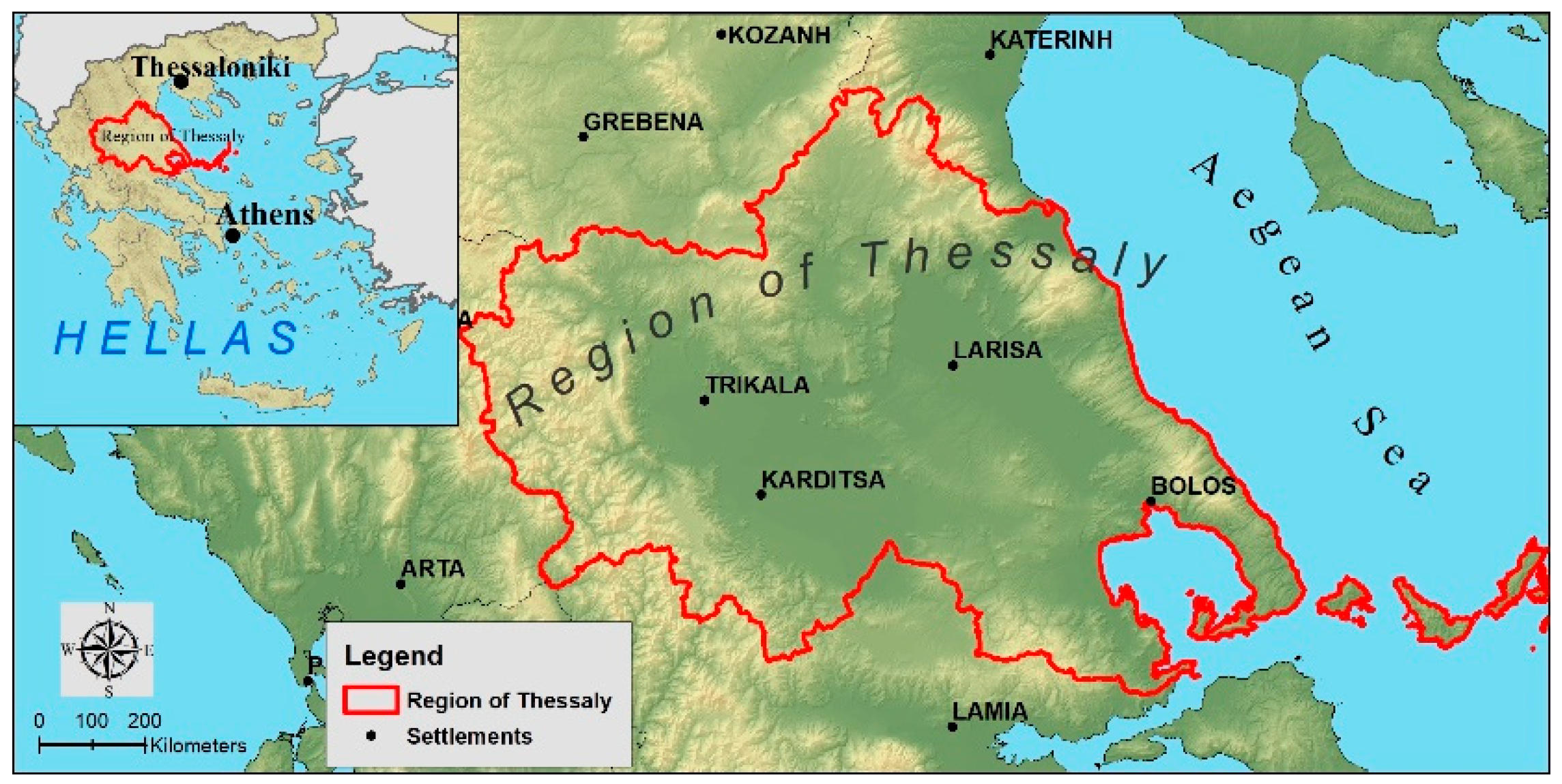
Figure 1. Study area.
Environsciproc 25 00009 g001
Figure 2. Variation of the actual daily ETa for cotton plots. Comparison between Hubis methodology and the farmer practices.
Environsciproc 25 00009 g002
Figure 3. Spatial distribution examples of the actual daily ETa for the cultivation of cotton (Farmer practices) and cotton (Hubis).
Environsciproc 25 00009 g003
Table 1. The 17 steps created for the operation of Sen-ET.
StepsProcedures
1Download Sentinel images
2Preprocessing of Sentinel-2
3Creation of a Digital Elevation Model (DEM)
4Creation of a land use map of the study area
5Leaf reflection and transmission assessment based on the chlorophyll and water content of the plants
6Estimation of fraction of green vegetation
7Production of land use/land cover maps
8Aerodynamic roughness assessment
9Pre-processing and downscaling of Sentinel-3 data
10From warp to template—Resampling into a standard image using GDAL Warp
11Sharpen land surface temperature
12Download WRF meteorological data by 3D S.A partner
13WRF meteorological data preparation based on the High-Resolution Digital Elevation Model (DEM) of the study area
14Long-wave irradiance estimation based on WRF meteorological data
15Estimation of net shortwave radiation based on WRF meteorological data and biophysical parameters
16Estimation of energy fluxes of the land surface
17Estimation of daily evapotranspiration
Disclaimer/Publisher’s Note: The statements, opinions and data contained in all publications are solely those of the individual author(s) and contributor(s) and not of MDPI and/or the editor(s). MDPI and/or the editor(s) disclaim responsibility for any injury to people or property resulting from any ideas, methods, instructions or products referred to in the content.