Abstract
Evaluating groundwater quality for certain purposes requires accurate quantitative and qualitative management, accessibility to the study area, and knowledge of the governing environmental processes. Groundwater resources are used to supply drinking water consumption alongside surface water in most countries. This study aims to investigate the quality of groundwater resources in the city of Ottawa, located in Ontario, Canada, using the Schoeller diagram and the Canadian Groundwater Quality Index (GWQI) in a fuzzy environment. To determine the water quality, the qualitative groundwater parameters including Ca, Mg, Na, Cl, SO4, HCO3, NO3, F, pH, TDS, TH, K, EC, and Alkalinity were considered in the Schoeller diagram and GWQI. Each parameter’s interpolated water quality map layer was prepared using the Kriging method in a GIS environment. The results of Schoeller’s diagram indicated that the range of drinking water quality was non-potable to inappropriate in more than 22% of the investigated groundwater resources. Moreover, the obtained results of the groundwater quality interpolation map layer based on the GWQI revealed that more than 70% of the groundwater resources were examined in the good and excellent range for drinking purposes. Finally, the obtained interpolated map layers of the Schoeller diagram and GWQI were integrated using GIS. Accordingly, the results indicate that the interpolation values of an integrated layer in the study area are well within the permissible limits, and the quality of the groundwater is suitable for drinking and other consumption purposes.
1. Introduction
Water is one of the substantial requirements in planning, developing, protecting, and controlling water resources. Improper and inefficient assessment and management of surface and groundwater could provide essential risks in the fields of human health and well-being, food security, industrial development, and the life of ecosystems [1,2,3,4]. Groundwater is considered one of the most important resources worldwide in the drinking and agriculture sectors. During the last few years, urbanization and population growth have led to an increase in the use of groundwater resources. Therefore, water quality evaluation is one of the significant problems in groundwater studies [5]. Variation in the quality of water resources is a great danger in usage by the agricultural, urban, and industrial sectors [6,7]. Several methods have been developed for water quality determination. Among these key methods to evaluate and manage groundwater resources for drinking purposes, the Schoeller diagram and the Water Quality Index (WQI) methods are the most common. In this study, to assess the water quality of groundwater, the Schoeller diagram, Canadian Groundwater Quality Index (GWQI), and Geographic Information System (GIS) were combined. Schoeller’s semi-logarithmic diagram is widely used to compare groundwater quality. This graph shows the concentration differences between water samples. It is classified based on several physio-chemical parameters to evaluate the quality of groundwater [8]. The GWQI method has high capability for groundwater quality assessment across the world. In the GWQI index based on GIS, several chemical parameters affecting the quality of groundwater are integrated. GIS is used for the interpolation and classification of water quality parameters. For this purpose, the kriging method was applied to interpolate each data layer of water quality parameters. Further, to reduce the uncertainties of the obtained results, interpolation map layers were converted to fuzzy set in GIS environment.
During recent years, multiple studies have been presented to evaluate water quality for drinking uses with the Schoeller diagram, water quality indices, and GIS software in different parts of the world [9,10]. In another study, NickPeyman and Mohammadzadeh, 2013, studied groundwater quality in the Mashhad plain aquifer by estimating the GQI index [11]. Soleimani et al., 2013, conducted a study entitled “Investigation of qualitative changes in water resources of east Koohsorkh using the GQI quality index in the GIS environment” [12]. Sadat-Noori et al., 2014, used a combination of the Water Quality Index (WQI) and GIS to determine the groundwater quality of the Saveh-Nobaran aquifer in Arak province, Iran. They used the kriging method in GIS for creating spatial distribution maps of pH, TDS, EC, TH, Cl, HCO, SO4, Ca, Mg, Na, and K [13]. In another study, Alavi et al., 2016, assessed the water quality of Dez eastern in Iran for drinking and agricultural uses with Schoeller and Wilcox diagrams, and the zoning water quality in a GIS environment considering physical and chemical parameters. They used the kriging interpolation method in GIS [14]. Farhan et al., 2020, investigated the Canadian Water Quality Index (CCME WQI) for drinking and domestic use in Mosul, Iraq. This research examined ten sampling sites along the river to collect samples from 2008 to 2014. The results showed that the water quality of the Tigris River was between 3.66 and 7.93, which is in the good and moderately good category [15]. Pourkhosravani et al., 2021, tried to evaluate groundwater resources’ chemical quality for drinking and agricultural purposes using Schoeller and Wilcox diagrams in the Sirjan Plain of Iran. Their classification map of each effective parameter was prepared using IDW-based GIS [16]. Given the fact that a comprehensive study on chemical parameter variations of groundwater quality has not been carried out in the study area, this study aimed to investigate the variation in groundwater quality parameters for drinking purposes in Ottawa city using the interpolation of GWQI and the Schoeller diagram in a GIS environment.
2. Materials and Methods
2.1. Study Area
Ottawa city, with the area of 2790 km2, is located in in the east of southern Ontario. This city is located at latitude 45°25′29″ N and longitude 75°41′42″ W, with an elevation of 70 m above sea level. The climate is semi-continental, with a warm, humid summer and a very cold winter. The temperature typically varies from −14 °C to 27 °C, while the mean precipitation is 920 mm. Rain falls throughout the year in Ottawa. The highest mean monthly rainfall in Ottawa is in July, with an average rainfall of 76 mm, while the lowest rainfall month is February, with an average rainfall of 12.7 mm. The study area involved different residential and industrial regions which supply the needed water from groundwater resources. Groundwater is one of the main sources of water in this area. There are lots of wells in the study area’s aquifers that have high potential as a source of drinking water. The location of the study area is illustrated in Figure 1.
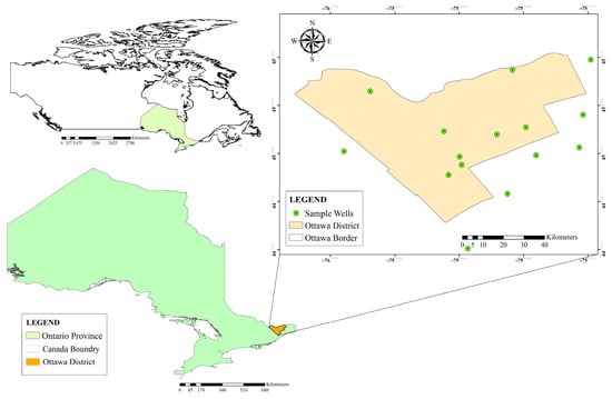
Figure 1.
Location of the study area and the sampling wells.
2.2. Methodology
In this study, the available groundwater level and chemistry data of 15 sample wells distributed across Ottawa city were first collected and analyzed from the Provincial Groundwater Monitoring Network (PGMN) Program of Ontario Province on the Ministry of the Environment, Conservation and Parks website [17]. Long-term qualitative data were used during a 17-year statistical period from 2002 to 2019. In this phase, the important parameters were considered to include Ca, Mg, Na, Cl, SO4, HCO3, NO3, F, pH, TDS, TH, K, EC, and alkalinity of groundwater quality.
In order to classify the water quality of groundwater and determine its type and characteristics, the GWQI index and Schoeller diagram method were used with the help of GIS software. Before that, the Schoeller diagram, a highly recommended method, was applied to investigate the quality of drinking water considering eight parameters including TDS, TH, Na, Cl, SO4, HCO3, Mg, and Ca. This diagram shows the concentration differences between the sample wells. It is drawn in six classes, including good, acceptable, average, inappropriate, completely inappropriate, and non-potable, based on several physio-chemical parameters to evaluate the quality of groundwater [8]. In the Schoeller diagram, an axis is considered separately for the parameters mentioned above, which determines drinking water quality [18]. Table 1 shows the classification of water quality using the Schoeller diagram method.

Table 1.
The classification of water quality using the Schoeller diagram method (mg/L).
Next, The GWQI Index was utilized to determine the water quality of groundwater based on Ca, Mg, Na, Cl, SO4, HCO3, NO3, F, pH, TDS, TH, K, EC, and alkalinity parameters. After the definition of the parameters, three factors to determine the GWQI must be calculated. The values of the three factors were calculated as follow [19]:
F1 shows the percentage of failed parameters relative to all of the measured parameters:
F2 demonstrates the percentage of failed tests:
F3 indicates the value whereby failed test values did not meet their guidelines. F3 is calculated in three steps.
Step 1. The number of times an individual’s concentration exceeds the guideline is called an “excursion” and is expressed as follows. When the test value should not exceed the guideline:
For cases where the test value should not be less than the guidelines:
Step 2. The cumulative amount by which individual tests are out of compliance is calculated by summing the excursions of individual tests from their guidelines and dividing by the total number of tests. This parameter, called the normalized sum of excursions, or nse, is determined as follows:
Step 3. Then, F3 is calculated by an asymptotic function that yields the normalized sum of excursions from instructions (nse) to a range between 0 and 100.
Once the three factors have been obtained, the index itself can be calculated by summing the three factors as a vector and using the Pythagorean theorem. Therefore, the sum of squares of each factor is equal to the square of GWQI.
A divisor of 1.732 normalizes the resulting values to a range between 0 and 100, where 0 represents the worst water quality and 100 represent the best water quality.
Computed GWQIs were classified into five categories including excellent, good, fair, marginal, and poor for human consumption in Table 2 [19]. The outcome of the index includes a number between 0 (worst water quality) and 100 (best water quality) [20,21].

Table 2.
The classification of water quality using the GWQI [19].
Afterward, a spatial classification map for each important parameter of the Schoeller diagram and GWQI Index method was prepared as a raster layer based on the kriging interpolation technique in GIS. It should be noted that, in order to reduce the uncertainty of all the classified raster parameters, each parameter layer was fuzzified based on the linear membership function in GIS [22,23,24]. Then, the final interpolation layers of the two methods (Schoeller and GWQI) were created by integrating fuzzy Raster layers as effective parameters using the fuzzy overlay tool. Finally, the classification map of the groundwater quality of the study area was generated by integrating the Schoeller and GWQI classified maps based on the overlaying method.
3. Results and Discussion
In this study, the water quality parameters of sample wells in the city of Ottawa for the drinking sector were studied using the Schoeller diagram and the GWQI Index. Therefore, based on Schoeller’s classification, the amounts of cations such as calcium (Ca), magnesium (Mg), sodium (Na), and anions such as chloride (Cl), sulfate (SO4), bicarbonate (HCO3), and two important parameters of total dissolved solids (TDS), and the total hardness (TH), were checked in the diagram, which is shown in Figure 2.
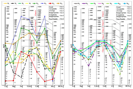
Figure 2.
The Schoeller diagram of the studied wells.
Regarding the discussion of limitations and practical implications in the current research, the groundwater quality in the urban area of Ottawa was explored. Using the approach implemented in this study, water quality could be analyzed concerning the environment, agriculture, and industry if more parameters were obtainable. However, due to the absence of pertinent environmental parameters such as BOD, COD, and DO, and industrial and agricultural parameters such as heavy metals including Fe, Cu, Zn, and As, and the time constraint involved in producing this article, only the drinking perspective was investigated concerning the quality of groundwater.
According to the diagrams (see Figure 2), the water quality of wells W1, W2, W4, W7, and W14 was in the good range; wells W3, W5, W6, W8, W9, W10, and W11 were in the acceptable range, and the rest of the wells were in the lower quality range. In general, it was concluded that about 71% of the parameter values were in the good range and 29% of the rest of the parameters were in other quality classes.
In the following, the values of each parameter of Schoeller’s diagram were interpolated based on the six classes of Schoeller’s classification in the ArcGIS software using the kriging method, and finally six classified maps were integrated with the Fuzzy Overlay tool in the form of the water quality classification map of Ottawa city (see Figure 3).
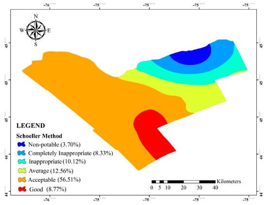
Figure 3.
Water quality classification map of Ottawa city using the Schoeller method.
Based on to the classified map of Schoeller, the water quality in the classification for the Ottawa city area was in six categories, from good to non-potable. In the south, west, and north-west areas towards the center, the water quality was good and fair for drinking purposes, and from the central area towards the east and northeast, the water quality decreased. Based on the location of two wells, W12 and W13, it can be pointed out that saltwater infiltrated the groundwater resources of these areas, considering the high amount of Na and Cl ions and also the proximity of these two wells to the Ottawa River. According to Schoeller’s classification map, some water samples may have good drinking quality, while those ones can contain other harmful and toxic substances; therefore, to solve this problem more parameters were used in the GWQI Index. Hence, those parameters such as electrical conductivity (EC), pH, alkalinity (mg/L CaCO3), Calcium (Ca), Sodium (Na), Magnesium (Mg), Potassium (K), Sulphate (SO4), Chloride (Cl), Fluoride (F), and Nitrate (NO3) were evaluated for the GWQI classification map.
Considering Equations (1)–(7), the annual average values of GWQI, considering Table 2, were calculated in the range of values 33 to 100. Therefore, the water quality in most wells for drinking purposes was rated in the range of excellent to good. The GWQI values were interpolated in the ArcGIS environment using the kriging method, shown in Figure 4. According to Figure 4, the southwest, west, and northwest regions towards the center of the study area have excellent and good drinking water quality, and from the central region toward the southeast, east, and northeast, the water quality is decreased due to the increase of NaCl ions.
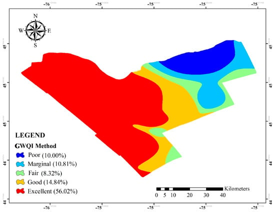
Figure 4.
Water quality classification map of Ottawa city using the GWQI Index.
Finally, after preparing Schoeller and GWQI classification maps, these two classified maps overlapped with the Fuzzy Overlay tool in ArcGIS. Additionally, the overlaid map was categorized into five classes from Excellent to Poor (see Figure 5). Furthermore, by investigating the integrated classification map, it was found that the values of groundwater quality were in the excellent and good class range for the area of Ottawa city in the south, west, and the northwest regions towards the center, and also the water quality range decreased in the east and northeast regions.
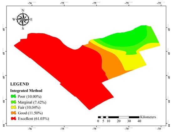
Figure 5.
Integrated water quality classification map of Ottawa city.
4. Conclusions
In this study, the main aim was to investigate groundwater quality through the combination of the Schoeller diagram and the Canadian Groundwater Quality Index (GWQI). This study tried to evaluate and analyze the water quality in Ottawa city in Ontario, Canada, based on long-term qualitative data from 15 sample wells between 2002 and 2019. The classified water quality maps of each chemical parameter were prepared using the kriging method based on a fuzzy set in the GIS environment. The obtained results showed that, based on the Schoeller diagram, most of the studied wells were located in good to acceptable quality regions regarding drinking purposes. According to the Schoeller classification map of groundwater resources, the acceptable class, with 56.51% of the aquifer area, and the non-potable class, with 3.70% of the aquifer area, made up the highest and lowest portions of the aquifer, respectively. Moreover, according to the GWQI water quality classification map results, 79.18% of the wells were in the fair to excellent range, and 10% were in the poor range. Finally, the results of assessing the integrated Schoeller and GWQI water quality classification map used for drinking purposes showed that, based on the values of these two methods, the water quality in the central areas and near-west areas were categorized into excellent and good classes, and from the central regions to the east, the water quality had gradually decreased. Moreover, the transferability of the proposed method and results can be discussed in light of the obtained outcomes. Our approach integrated the GWQI index, Schoeller diagram, and GIS to develop a model that can be utilized for agricultural, industrial, and environmental purposes by including several chemical parameters. The GWQI index enabled us to expand the model to encompass other water quality diagrams, such as Wilcox and Piper. Moreover, our study’s reliability and transparency provide significant insights for researchers and decision-makers to analyze and make informed decisions about the quality of drinking water. These results show that the proposed method is transferable to more extensive case studies, providing valuable insights for various water quality applications.
Author Contributions
Conceptualization: A.N., F.R. and H.B.; methodology: A.N. and F.R.; software: A.N.; validation, F.R.; formal analysis, H.B. and A.N.; data curation, A.N. and F.R., writing—original draft preparation, A.N. and H.B.; writing—review and editing, H.B.; visualization, A.N., F.R. and H.B.; supervision: H.B. All authors have read and agreed to the published version of the manuscript.
Funding
This research received no external funding.
Institutional Review Board Statement
Not applicable.
Informed Consent Statement
Not applicable.
Data Availability Statement
Data available on request due to restrictions e.g., privacy or ethical.
Conflicts of Interest
The authors declare no conflict of interest.
References
- Ahmad, S.; Murray, R. World Environmental and Water Resources Congress 2020: Water Resources Planning and Management and Irrigation and Drainage; American Society of Civil Engineers (ASCE): Reston, VA, USA, 2020. [Google Scholar] [CrossRef]
- Noori, A.; Bonakdari, H.; Morovati, K.; Gharabaghi, B. Development of optimal water supply plan using integrated fuzzy Delphi and fuzzy ELECTRE III methods—Case study of the Gamasiab basin. Expert Syst. 2020, 37, e12568. [Google Scholar] [CrossRef]
- Salimi, A.H.; Noori, A.; Bonakdari, H.; Samakosh, J.M.; Sharifi, E.; Hassanvand, M.; Gharabaghi, B.; Agharazi, M. Exploring the role of advertising types on improving the water consumption behavior: An application of integrated fuzzy AHP and fuzzy VIKOR method. Sustainability 2020, 12, 1232. [Google Scholar] [CrossRef]
- Noori, A.; Bonakdari, H.; Salimi, A.H.; Gharabaghi, B. A group Multi-Criteria Decision-Making method for water supply choice optimization. Socioecon. Plann. Sci. 2021, 77, 101006. [Google Scholar] [CrossRef]
- Umar, R.; Ahmed, I.; Alam, F. Mapping groundwater vulnerable zones using modified DRASTIC approach of an alluvial aquifer in parts of central Ganga plain, western Uttar Pradesh. J. Geol. Soc. India 2009, 73, 193–201. [Google Scholar] [CrossRef]
- Cloern, J.E. Patterns, pace, and processes of water-quality variability in a long-studied estuary. Limnol. Oceanogr. 2019, 64, S192–S208. [Google Scholar] [CrossRef]
- Radfard, M.; Soleimani, H.; Azhdarpoor, A.; Faraji, H.; Mahvi, A.H. Dataset on assessment of physical and chemical quality of groundwater in rural drinking water, west Azerbaijan Province in Iran. Data Br. 2018, 21, 556–561. [Google Scholar] [CrossRef] [PubMed]
- Güler, C.; Thyne, G.D.; McCray, J.E.; Turner, A.K. Evaluation of graphical and multivariate statistical methods for classification of water chemistry data. Hydrogeol. J. 2002, 10, 455–474. [Google Scholar] [CrossRef]
- Pour, H.V.; Sayari, M.; Bayat, N.; Forutan, F. Qualitative and Quantitative Evaluation of Groundwater in Isfahan Najaf Abad Study Area. J. Middle East Appl. Sci. Technol.(JMEAST) 2014, 16, 523–530. [Google Scholar]
- Jamshidzadeh, Z.; Mirbagheri, S.A. Evaluation of groundwater quantity and quality in the Kashan Basin, Central Iran. Desalination 2011, 270, 23–30. [Google Scholar] [CrossRef]
- Nickpeyman, V.; Mohammadzadeh, H. Evaluation of spatial variations of groundwater quality in Mashhad Plain using GQI index. Presented at the National Conference on Exploration of Ground Resources. In National Conference on Exploration of Ground Resources; Hamedan University: Hamedan, Iran; 2013. (In Persian)
- Soleimani, S.; Mahmoudi-Gharaei, M.; Ghasemzadeh, F.; Planet, A. Investigation of quality changes of west water resources of the red mountain using GQI quality index in GIS environment. J. Earth Sci. 2013, 89, 175–189. (In Persian) [Google Scholar]
- Sadat-Noori, S.M.; Ebrahimi, K.; Liaghat, A.M. Groundwater quality assessment using the Water Quality Index and GIS in Saveh-Nobaran aquifer, Iran. Environ. Earth Sci. 2014, 71, 3827–3843. [Google Scholar] [CrossRef]
- Alavi, N.; Zaree, E.; Hassani, M.; Babaei, A.A.; Goudarzi, G.; Yari, A.R.; Mohammadi, M.J. Water quality assessment and zoning analysis of Dez eastern aquifer by Schuler and Wilcox diagrams and GIS. Desalination Water Treat. 2016, 57, 23686–23697. [Google Scholar] [CrossRef]
- Farhan, A.F.; Al-Ahmady, K.K.; Al-Masry, N.A.-A. Assessment of Tigris River Water Quality in Mosul for Drinking and Domestic Use by Applying CCME Water Quality Index. IOP Conf. Series: Mater. Sci. Eng. 2020, 737, 012204. [Google Scholar] [CrossRef]
- Pourkhosravani, M.; Gohari, J.; Sayari, N.; Pourkhosravani, M.; Gohari, F.J.; Sayari, N. Groundwater Quality and Suitability for Different Uses in the Sirjan County. Desert Ecosyst. Eng. J. 2021, 3, 43–58. [Google Scholar]
- Ministry of the Environment, Conservation and Parks. Available online: https://www.ontario.ca/page/ministry-environment-conservation-parks (accessed on 15 January 2023).
- Melloul, A.; Collin, M. The ‘principal components’ statistical method as a complementary approach to geochemical methods in water quality factor identification; application to the Coastal Plain aquifer of Israel. J. Hydrol. 1992, 140, 49–73. [Google Scholar] [CrossRef]
- CCME. Canadian Water Quality Guidelines for the Protection of Aquatic Life: CCME Water Quality Index User’s Manual 2017 UPDATE, Canadian Environmental Quality Guidelines. Can. Counc. Minist. Environ. 2017, 1–23. Available online: https://ccme.ca/en/res/wqimanualen.pdf (accessed on 10 October 2020).
- Khan, A.A.; Paterson, R.; Khan, H. Modification and application of the Canadian Council of Ministers of the Environment Water Quality Index (CCME WQI) for the communication of drinking water quality data in Newfoundland and Labrador. Water Qual. Res. J. Can. 2004, 39, 285–293. [Google Scholar] [CrossRef]
- Cash, K.; Wright, R. Canadian Water Quality Guidelines for the Protection of Aquatic Life; CCME: Ottawa, ON, Canada, 2001. [Google Scholar]
- Ketata, M.; Gueddari, M.; Bouhlila, R. Use of geographical information system and water quality index to assess groundwater quality in el khairat deep aquifer (enfidha, central east tunisia). Arab. J. Geosci. 2012, 5, 1379–1390. [Google Scholar] [CrossRef]
- Lo, C.P.; Yeung, A.K. Concepts and Techniques of Geographic Information Systems; Pearson Prentice Hall: London, UK, 2007. [Google Scholar]
- Noori, A.; Bonakdari, H.; Hassaninia, M.; Morovati, K.; Khorshidi, I.; Noori, A.; Gharabaghi, B. A reliable GIS-based FAHP-FTOPSIS model to prioritize urban water supply management scenarios: A case study in semi-arid climate. Sustain. Cities Soc. 2022, 81, 103846. [Google Scholar] [CrossRef]
Disclaimer/Publisher’s Note: The statements, opinions and data contained in all publications are solely those of the individual author(s) and contributor(s) and not of MDPI and/or the editor(s). MDPI and/or the editor(s) disclaim responsibility for any injury to people or property resulting from any ideas, methods, instructions or products referred to in the content. |
© 2023 by the authors. Licensee MDPI, Basel, Switzerland. This article is an open access article distributed under the terms and conditions of the Creative Commons Attribution (CC BY) license (https://creativecommons.org/licenses/by/4.0/).