Abstract
In this study, we present a comprehensive and detailed analysis to identify and quantify spatial patterns of heavy, very heavy, and extremely heavy rainfall, as well as the trends that have developed over the past seven decades (1951 to 2020) of the monsoon months (June to September) under a warming scenario. We also project these extreme rainfall counts during the near (2036–2060) and late 21st century (2075–2099) for comparison to the historical period (1990–2014). The 5-day maximum rainfall over the provinces of Sindh and Baluchistan is currently about 75% more intense than it would have been without the climate warming by 1.2 °C, and the 60-day rainfall across the basin is currently about 50% more intense. This means that heavy rainfall is now more likely to occur. Due to the high-level of rainfall variability in the area, there is significant uncertainty regarding these estimations, and the causes of the observed changes are not just limited to climate change. However, most of the models and observations we have analyzed for the 5-day rainfall extreme indicate that severe rainfall has been heavier than Pakistan has warmed. According to some of these models, the intensity of the rainfall might have increased by 50% due to climate change under the 5-day event threshold. The model predicts that rainfall intensity will greatly rise in the future for the 5-day event in a climate that is 2 °C warmer than it was in pre-industrial times, while the uncertainty is still quite high for the 60-day monsoon rainfall.
1. Introduction
The Indus Basin contains 1.10 million square kilometers, with Pakistan contributing 63 percent, India 29 percent, and Afghanistan and China 8 percent. These entire provinces, such as the province of Khyber Pakhtunkhwa, Sindh, and towards the eastern part of Punjab and Baluchistan, cover the Indus Basin River [1]. The Indus River arises in Tibet (China) at Mount Kailash (Mansarovar Lake) and is divided into two sections: Upper Indus and Lower Indus. The water flows from the upper side of the Indus and downstream to the Guddu barrage. The glaciers of Hindu Kush and Karakoram supply water to the Indus River. However, it is the main source of fresh water and it supports 90 percent of agricultural land, and industrial and household requirements [2].
The Indu’s basin hydrology is influenced by the interaction of three distinct regimes and their responses to climatic conditions: the glacial, nival (snow melt), and rainy regimes. To assess how climate change may affect the Indus Basin, an understanding of the hydrological processes that determine river flow is essential [3]. About 25 to 35 percent of the water flow in the Indus River is generated by the glacial phase. Due to the region’s naturally diversified geography and climate, its flow patterns are influenced by a wide range of responses. Summer temperature is positively connected with runoff rates in the glacial regime (i.e., a higher temperature led to more runoff) and negatively correlated with summer precipitation [4].
Climate Change will have a significant impact on global socio-ecological systems in the future decades, affecting the hydrological cycle, agricultural production, and basic ecosystems [5]. Rising temperatures in basins that rely heavily on glaciers melting will almost certainly result in a rise in stream flow in the short-term, but a decrease in the long-term. This is because the overall quantity of glacier melt is a tradeoff between increasing melt rates on the one hand and decreasing glacier volumes on the other. When the trend of glacier melt shifts from positive to negative [6], due to climate change, this warming effect is predicted to influence rainfall patterns and increase the frequency of extreme weather events, such as flooding, drought, and other natural disasters. Furthermore, rising CO2 concentrations will have a direct impact on crop growth and development, affecting agricultural land use and crop yields [7].
Planning for climate impacts, creating resistance to such impacts, and enhancing civilization’s capabilities to react and recover are all aspects of adjustment [8]. This may help to decrease the damages and disruptions caused by climate change. Governments should play a bigger role in promoting water demand reduction initiatives. Considering the risks of increasing per capita water shortages, provincial governments should take initiative by increasing agricultural, industrial, municipal, and domestic water conservation [9].
This should include more investment for programs that encourage water conservation practices, such as flood and rainwater harvesting. Water pricing rules that properly reflect the true cost of water usage should also be implemented by governments [10].
2. Data and Methods
Observational Data
The National Climate Centre (NCC) of The Pakistan Meteorological Department (PMD) provided the daily gridded rainfall dataset with a spatial resolution of 0.25° × 0.25° during the monsoon period (June—September) in the Pakistan region between 1951 and 2020. A network of 47 stations dispersed throughout the Pakistan landmass was used to create the gridded dataset (Figure 1).
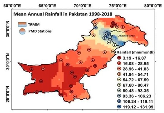
Figure 1.
Pakistan Station point [11].
One of the main ways to understand how the climate has changed in the past and how it might change in the future is using climate models. In this analysis, we evaluate predicted changes in the frequency of extreme rainfall events for the near 21st century (2036–2060) and late 21st century (2075–2099), with a primary focus on the distribution of heavy, very heavy, and extremely heavy rainfall.
With the historical period typically beginning in 1950 (or 1970) and ending in 2005, followed by the Shared Socio-economic Pathways scenarios until the 21st century, we used the model simulations for South Asia that were available from the CMIP 6 (Couple Model Intercomparison Project Phase 6). Global Climate Model (GCM) simulations are downscaled and used to create regional climate model (RCM) simulations.
3. Result and Discussion
The research presented is a comprehensive understanding of how CIMP6 models reflect extreme events at national and global levels. To understand the changes in extreme occurrences, the visualizations offer several viewpoints on past conditions, as well as possibly the future. Future periods and scenarios with a focus on 2025, 2050, 2075, and 2085 can be compared to the baseline climate (Historical Period, 1985–2014, centered on 2000). The extreme indicators do not stand for location-specific (station level) extremes but rather qualitative projection results that directly reflect global model output.
When compared to the mean precipitation, extreme precipitation events often exhibit higher magnitudes of change and distinct indications. As Earth gets warmer, the ability of air to carry more moisture increases exponentially, thus increasing the possibility of more precipitation. This can increase the risk of flooding, since extreme weather events are expected more frequently. Only in regions where precipitation is much less frequent can a trend toward more rainfall be reversed, resulting in an increase in return periods rather than a decrease in the frequency of major occurrences as shown in Figure 2.
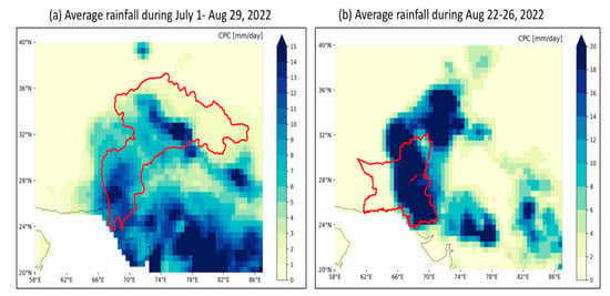
Figure 2.
Annual maximum of the mean 60-day precipitation and the annual maximum of the mean 5-day precipitation in monsoon season at the site of Sindh and Baluchistan [12].
The characteristics of the climate as represented by extreme events and distinct from those of the long-term means since they reflect unusual weather events. For a limited number of repetition intervals, return levels (precipitation amounts displayed in mm) are available. In addition, the relationship between the return periods (represented in years) and the spatial distribution of fixed precipitation magnitudes (also known as return levels) can be examined. When the annual exceedance probability is needed, the inverse of the return period is needed. The historical return levels are then used to assess potential adjustments to the related reappearance interval (return period in years). The colors show, for instance, whether an occurrence that has traditionally occurred every 20 years will occur more frequently in the future (green) or less frequently (brown). Projections are therefore displayed as future return times (in years) that refer to the current reference point. This future change in return period can also be expressed as a change in the chance of future annual extremes. This product, displayed as a factor, supplies a potential increase or decrease in the frequency of an event as shown in Figure 3, Figure 4, Figure 5 and Figure 6.
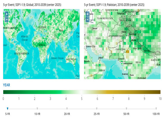
Figure 3.
Global precipitation from the year (2010–2039); Source: [13].
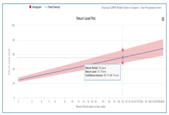
Figure 4.
Precipitation return level according to long scale; Source: [13].
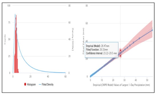
Figure 5.
Compare Model and observation value of Precipitation; Source: [13].
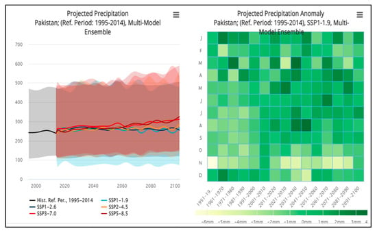
Figure 6.
Projected Precipitation in Pakistan; Source: [13].
Table 1 shows the frequency of flood events for different return periods (5, 10, 20, 25, and 50 years) and magnitudes (10th, median, and 90th percentiles) for historical data. The values in each cell represent the flood magnitude in cubic meters per second. Table 1 shows the historical values of precipitation events at different levels, from 25 mm to 200 mm, and their corresponding frequency distributions, represented by the 10th, 50th (median), and 90th percentiles. For example, in historical data, the median precipitation event at 25 mm level occurred 3.16 times, while the 90th percentile precipitation event at 200 mm level occurred 11,719 times.

Table 1.
Extreme Precipitation events from the years 1985 to 2014; Source [13].
Table 2 provides information on the intensity of rainfall for different events and return periods. The events are represented by the amount of rainfall in millimeters (mm) for 25 mm, 50 mm, 100 mm, 150 mm, and 200 mm. The return period is expressed in years, ranging from a 10-year to a 90-year return period. The data is presented for two scenarios: historical and a certain location. In the historical scenario, the data shows the median (50th percentile) and 90th percentile rainfall for each event and return period. For instance, the median rainfall amount for the 25 mm event is 0.19 mm, while the 90th percentile rainfall is 0.62 mm. Similarly, for the 200 mm event, the median rainfall amount is 0.02 mm, while the 90th percentile rainfall is 0.01 mm. In the second scenario, the table shows the median and 90th percentile rainfall for the same events and return periods but for a specific location. The location is not mentioned in the table, but it can be assumed that the values represent a location with a certain climate or weather pattern.

Table 2.
Annual Exceedance Probability of precipitation.
Table 3 displays data on different events and the associated return periods in years for each of the five Shared Socioeconomic Pathways (SSPs). For each event and return period combination, the table shows the 10th percentile, median, and 90th percentile of the estimates. The events refer to different climate-related hazards such as floods, drought, and heatwaves, and the return period refers to the average number of years between events of a similar magnitude or severity. The SSPs represent different scenarios of future socio-economic development and associated greenhouse gas emissions. The SSP1-19 scenario assumes a future world with low challenges to mitigation and adaptation, SSP1-26 represents a future world with moderate challenges, SSP2-45 represents a world with intermediate challenges, SSP3-70 represents a world with high challenges, and SSP5-85 represents a world with very high challenges. The numbers in the table represent estimates of the impacts of climate change under each scenario, with higher numbers indicating more severe impacts. For example, the table shows that under SSP3-70, the median estimate for a 50-year flood event is 8.30, while the 10th percentile estimate is 3.20 and the 90th percentile estimate is 14.23. This suggests that there is considerable uncertainty in the estimates, but overall, the expected impact of climate change under SSP3-70 is relatively high compared to the other scenarios.

Table 3.
Future Return Period (2010–2039) [13].
Table 4 shows the magnitude of different events, expressed as a percentage of a reference level of 10, for different return periods (5-year, 20-year, 25-year, 50-year, and 100-year) under different Shared Socioeconomic Pathways (SSPs). The first column “Event” represents the different types of events being considered, but no further details about the events are provided. The next six columns present the magnitude of the events for each return period, as well as the median, 90th, and 10th percentiles. For example, for the 5-year event, the table shows the median magnitude of the event, as well as the 90th and 10th percentiles, under each SSP. The table presents information for five different SSPs: SSP1-19, SSP1-26, SSP2-45, SSP3-70, and SSP5-85. Each of these SSPs represents a different scenario of future socioeconomic development and greenhouse gas emissions, as defined by the Intergovernmental Panel on Climate Change (IPCC). The information in this table can be used by decision-makers to assess the potential impacts of different events under different SSPs and to inform decision-making regarding adaptation and mitigation measures. It can also be used to assess the relative risks associated with different SSPs and to inform policymaking regarding climate change mitigation and adaptation strategies.

Table 4.
Future Return Period of Precipitation (2035–2064) [13].
Table 5 presents information about different events and their corresponding percentiles for different return periods (5-year, 20-year, 25-year, 50-year, and 100-year) based on a reference level of 10. The first column “Event” is the name or type of event being considered, but no further details about the event are given in this table. The next six columns show the percentile values for the magnitude of the event for each return period. For example, the 5-year event has a magnitude at the median of the distribution, as well as at the 90th and 10th percentiles. The magnitude is expressed as a percentage of the reference level of 10. The median represents the middle value of the distribution, with half of the events having a magnitude above the median and half having a magnitude below it. The 90th percentile is the magnitude above which only 10% of the events occur, while the 10th percentile represents the magnitude above which 90% of the events occur. The information in this table could be used by risk assessors and planners to estimate the probability of different events occurring and their corresponding magnitudes. This can help in designing the right measures to mitigate the risks and to protect people and property from potential damages caused by the events.

Table 5.
Future Return Period of Precipitation (2060–2089) [13].
Table 6 presents information on the magnitude of events with different return periods (5-year, 20-year, 25-year, 50-year, and 100-year) under five different Shared Socioeconomic Pathways (SSPs): SSP1-19, SSP1-26, SSP2-45, SSP3-70, and SSP5-85. The SSPs are scenarios that describe possible future developments of the world’s social, economic, and environmental systems based on assumptions about factors such as population growth, economic development, and technological change. The values in the table represent the magnitude of the event in a given year for each return period (e.g., the 5-year event has a 2.58 magnitude under SSP1-19, a 2.34 magnitude under SSP1-26, a 2.06 magnitude under SSP2-45, a 1.57 magnitude under SSP3-70, and a 1.43 magnitude under SSP5-85). The magnitude is expressed as a percentage of a reference level (e.g., 10% for the 5-year event) and is shown for three percentiles: the median, the 90th percentile, and the 10th percentile. This information can be used by planners and decision-makers to assess the risks associated with different scenarios and to develop strategies for managing them. For example, they can use this information to identify areas that are more vulnerable to extreme events and to plan infrastructure investments or adaptation measures to reduce their exposure to risks.

Table 6.
Future Return Period of Precipitation (2070–2099) [13].
4. Conclusions
The flooding was a direct result of the excessive monsoon rain that occurred throughout the summer of 2022, which was made even worse by shorter periods of very heavy rain that affected the provinces of Sindh and Baluchistan, especially the month of August. Therefore, for the Indus basin and the two provinces, respectively, we evaluated the maximum rainfall over 60 days and over 5 days during the monsoon season.
In the current environment, the return time for both mentioned events are approximately 1 in 100 years. However, the amount of rain in the Indus basin varies greatly from year to year for a variety of reasons, including its close relationship to the ENSO cycle. Therefore, precise quantification is challenging.
We compared the trends in climate models with and without the human-induced increases in greenhouse gases to find the contribution of human-induced climate change to these observed changes. The affected areas are in the westernmost extremes of the monsoon region. Here, the properties of rainfall in the dry western and moist eastern parts differ significantly.
Many of the climate models that are now available have difficulty simulating these rainfall features. The incidence and intensity of extreme rainfall tend to change significantly less for those that pass our evaluation test than the trends we found in the observations. It is impossible to assess the overall contribution of human-induced climate change because of this gap, which points to the possibility that long-term variability or processes that our study may not have considered can have a significant impact. Our findings are consistent with current IPCC reports.
There is an urgent need to reduce Pakistan’s vulnerability to extreme weather, both currently and in case of the possible future increase in high rainfall over Pakistan due to climate change.
Author Contributions
Conceptualization, H.M. and M.Z.; Introduction, M.A.S.; Materials and Methods, H.M., M.Z. and M.D.M.; Results and Discussions, M.S. and R.M.S.; Conclusions, M.Z. and M.A.S. writing original draft preparation, H.M.; editing, M.S. All authors have read and agreed to the published version of the manuscript.
Funding
This research received no external funding.
Institutional Review Board Statement
Not applicable.
Informed Consent Statement
Not applicable.
Data Availability Statement
Not applicable.
Conflicts of Interest
The authors declare no conflict of interest.
References
- Asadieh, B.; Krakauer, N.Y. Global change in streamflow extremes under climate change over the 21st century. Hydrol. Earth Syst. Sci. 2017, 21, 5863–5874. [Google Scholar] [CrossRef]
- Sharma, B.; Cai, X.; Decondappa, D. Impact of Climate Change on Water Resources and Agricultural Production in the Indus Basin, South Asia; IWRA: Madison, WI, USA, 2021. [Google Scholar]
- Khan, A.; Koch, M.; Tahir, A. Impacts of Climate Change on the Water Availability, Seasonality and Extremes in the Upper Indus Basin (UIB). Sustainability 2020, 12, 1283. [Google Scholar] [CrossRef]
- Chase, K.J.; Haj, A.E.; Regan, R.S.; Viger, R.J. Potential effects of climate change on streamflow for seven watersheds in eastern and central Montana. J. Hydrol. Reg. Stud. 2016, 7, 69–81. [Google Scholar] [CrossRef]
- Eekhout, J.; de Vente, J. Assessing the effectiveness of Sustainable Land Management for large-scale climate change adaptation. Sci. Total. Environ. 2019, 654, 85–93. [Google Scholar] [CrossRef] [PubMed]
- Lutz, A.F.; Immerzeel, W.; Kraaijenbrink, P.; Shrestha, A.; Bierkens, M. Climate change impacts on the upper indus hydrology: Sources, shifts and extremes. PLoS ONE 2016, 11, e0165630. [Google Scholar] [CrossRef] [PubMed]
- Liu, Z.; Herman, J.D.; Huang, G.; Kadir, T.; Dahlke, H.E. Identifying climate change impacts on surface water supply in the southern Central Valley, California. Sci. Total. Environ. 2021, 759, 143429. [Google Scholar] [CrossRef] [PubMed]
- Dash, J.W. Climate Change Risk Management. In World Scientific Encyclopedia of Climate Change; World Scientific Publishing Co. Pte Ltd.: Hackensack, NJ, USA, 2021; pp. 189–202. [Google Scholar]
- Parry, J.-E.; Osman, H.; Terton, A.; Asad, S.; Ahmed, T. The Vulnerability of Pakistan’s Water Sector to the Impacts of Climate Change: Identification of Gaps and Recommendations for Action; United Nations Development Programme: New York, NY, USA, 2017. [Google Scholar]
- Li, Z.; Jin, J. Evaluating climate change impacts on streamflow variability based on a multisite multivariate GCM downscaling method in the Jing River of China. Hydrol. Earth Syst. Sci. 2017, 21, 5531–5546. [Google Scholar] [CrossRef]
- Safdar, F.; Khokhar, M.F.; Mahmood, F.; Khan, M.Z.A.; Arshad, M. Observed and predicted precipitation variability across Pakistan with a special focus on winter and pre-monsoon precipitation. Environ. Sci. Pollut. Res. 2023, 30, 4510–4530. [Google Scholar] [CrossRef] [PubMed]
- Blunden, J.; Boyer, T. State of the climate in 2020. Bull. Am. Meteorol. Soc. 2021, 102, S1–S475. [Google Scholar] [CrossRef]
- Harris, I.; Osborn, T.J.; Jones, P.; Lister, D. Climate Change Knowledge Portal Report. Sci. Data 7; Climate Change Knowledge Portal: Washington, DC, USA, 2020. [Google Scholar]
Disclaimer/Publisher’s Note: The statements, opinions and data contained in all publications are solely those of the individual author(s) and contributor(s) and not of MDPI and/or the editor(s). MDPI and/or the editor(s) disclaim responsibility for any injury to people or property resulting from any ideas, methods, instructions or products referred to in the content. |
© 2023 by the authors. Licensee MDPI, Basel, Switzerland. This article is an open access article distributed under the terms and conditions of the Creative Commons Attribution (CC BY) license (https://creativecommons.org/licenses/by/4.0/).