Next Article in Journal
Enhancement of Atmospheric Water Harvesting via Salt-Infused Sponges and Peltier Devices
Previous Article in Journal
Evaluation of GPM IMERG Performance Over the Lake Titicaca Basin at Different Time Scales
 
 
Please note that, as of 4 December 2024, Environmental Sciences Proceedings has been renamed to Environmental and Earth Sciences Proceedings and is now published here.
Proceeding Paper

Numerical Estimation of the Black Sea Circulation near the Continental Slope Using SKIRON and ERA5 Atmospheric Forcing †

Wave Theory Department, Marine Hydrophysical Institute, Russian Academy of Sciences, 2 Kapitanskaya St., Sevastopol 299011, Russia
*
Author to whom correspondence should be addressed.
Presented at the 7th International Electronic Conference on Water Sciences, 15–30 March 2023; Available online: https://ecws-7.sciforum.net/.
Environ. Sci. Proc. 2023, 25(1), 61; https://doi.org/10.3390/ECWS-7-14305
Published: 3 April 2023
(This article belongs to the Proceedings of The 7th International Electronic Conference on Water Sciences)

Abstract

:
Assessments of the state of sea waters and complex studies of the marine environment in various ocean basins are often based on hydrophysical fields (currents, temperature, salinity, etc.) obtained through the use of numerical modeling. The regular fields of currents are of particular importance for assessing the transport of impurities in sea waters at different depths, including pollutants of various origins. The results of hydrophysical field modeling, in turn, depend on the conditions set at the boundaries of the basin. Therefore, the correct setting of rapidly changing atmospheric conditions is extremely important for the reconstruction of marine dynamics. This paper presents model estimates of the Black Sea circulation obtained using two different datasets, SKIRON and ERA5, as atmospheric forcing. Numerical experiments for 2016 are carried out based on the eddy-resolving MHI-model. ARGO floats and R/V Cruises data are used to validate the simulation results. It was discovered that temperature and salinity RMSE between the model and measurement data are decreased under ERA5 forcing. Near the northeastern continental slope, a change in the direction of the alongshore subpycnocline current, which is detected in the ARGO float trajectory, is modeled using ERA5 rather than SKIRON. Therefore, for a more accurate reconstruction of the Black Sea circulation, ERA5 atmospheric forcing is recommended.

1. Introduction

The circulation in the upper layer of each ocean is in direct contact with the atmosphere and is related to the distribution of meteorological parameters [1,2,3]. At the same time, the influence of atmospheric forcing on the structure of deepwater circulation is not so clear. For the Black Sea, this problem is complicated by the presence of a strong vertical density gradient (permanent pycnocline) at 50–100 m horizons, which blocks vertical seawater exchange [3].
Regional features of density stratification often arise near the Black Sea continental slope due to the mixing and lowering processes of surface waters along the slope into the deep sea layers [3,4]. The formation of density anomalies here can be caused by external forcing at the boundaries of the basin (including wind, river runoff, etc.), the sinking of denser waters down the continental slope, and the transfer of water with thermohaline characteristics that differ from the ones in eddies [4,5]. These processes are especially important in the northeastern part of the basin due to the narrow and steep continental slope in this region. The seawater density anomalies formed near the slope can lead to the transformation of the velocity field at deep horizons [5]. Thus, the generation of unsteady deepwater undercurrents is found out there [6].
Below the permanent pycnocline, the Black Sea waters become warmer and more saline accumulates towards the bottom [2]. At the same time, anticyclones can form near the shelf edge and then can move along the slope [4,5,7]. In the centers of the anticyclones, subpycnocline waters that are colder and contain less saline deepen, and their movement contributes to the transfer of thermohaline anomalies and the corresponding perturbations of dynamical fields. Such complicated dynamics near the continental slope require a detailed and accurate reconstruction of all hydrophysical characteristics, which is only possible if boundary conditions are correctly specified.

2. Materials and Methods

The Black Sea circulation was reconstructed by an eddy-resolving model from the Marine Hydrophysical Institute (MHI-model) [8]. The model was based on the Navier–Stokes equations in Boussinesq and hydrostatic approximations. Vertical turbulent mixing was described by the Mellor–Yamada closure model 2.5, and horizontal mixing was described using a bilaplacian operator with constant coefficients. The model circulation was driven by atmospheric forcing, including wind stress, heat fluxes, precipitation, and evaporation, on the sea surface. The climatological Black Sea rivers runoff and exchange through the straits were considered. Data assimilation (except for the satellite sea surface temperature data) was not used in the discussed numerical experiments. The MHI-model was implemented on a C-grid with a resolution of (1/48)° longitude, (1/66)° latitude, and 27 z-levels vertically. The detailed model description is presented in [8].
Basin bathymetry was built from EMODnet data [9]. The initial data were obtained from the Black Sea Physical Reanalysis CMEMS [10]. All initial and input fields were linearly interpolated in the MHI-model grid nodes.
In this work, two numerical simulations with identical model setups but different atmospheric forcing were carried out for the year 2016. In the first simulation (SKIRON-experiment), the forcing included 2 h of data on wind velocity, thermal, latent, sensible, and solar heat fluxes, evaporation, and precipitation provided by the SKIRON/Dust modeling system (Greece), with a spatial resolution of 0.1° [11]. In the second simulation (ERA5-experiment), the forcing was based on the freely available hourly data of reanalysis supported by the European Centre for Medium-Range Weather Forecasts for the global climate, with a resolution of 0.25° [12].
Comparative analysis of the SKIRON and ERA5 data showed a significant difference in wind forcing in the Black Sea region. As can be seen in Figure 1, the ERA5 wind stress is stronger than SKIRON one by about 25–30%, and the repeatability of NN-E and N-E wind directions (forming surface cyclonic circulation of the Black Sea) is higher. The remaining fluxes in ERA5 and SKIRON are close to each other, with there being some excess (15–20%) ERA5 data on total heat flux during the year and mass flux (precipitation minus evaporation) in autumn and winter.

3. Results

Daily data on sea surface height and three-dimensional fields of seawater temperature, salinity, and current velocity for the year 2016 were obtained in the two numerical experiments described above. The next stages of the study compare the simulation results with observational data (validation) and analyze deepwater circulation with a focus on the continental slope region, where the most interesting features of the currents are observed. In the northeastern part of the sea, so-called undercurrents (opposite to the Black Sea surface basin-scale cyclonic gyre—the Rim Current [1,2,3]) are detected at a depth of 200 m for the period 9 June 2016–14 October 2016, according to ARGO data.
Validation of the model fields was performed based on temperature and salinity measurement data obtained by ARGO profiling floats [13] and R/V «Professor Vodyanitsky» Cruises 87, 89, and 91 [14] in 2016. Our validation methodology is described in [8] (Section 2.2). Root mean square errors RMSE between the model and in situ data for both experiments are presented in Table 1. The temperature RMSE in the upper layer (0–300 m) decrease in the ERA5-experiment compared to the SKIRON-experiment. The highest decrease in temperature error was observed at a depth of 0–30 m. The model salinity in the ERA5-experiment correlated more at a depth of 30–300 m. Therefore, the permanent pycnocline and seasonal thermocline layers in the ERA5-experiment are closer to the measurement data.
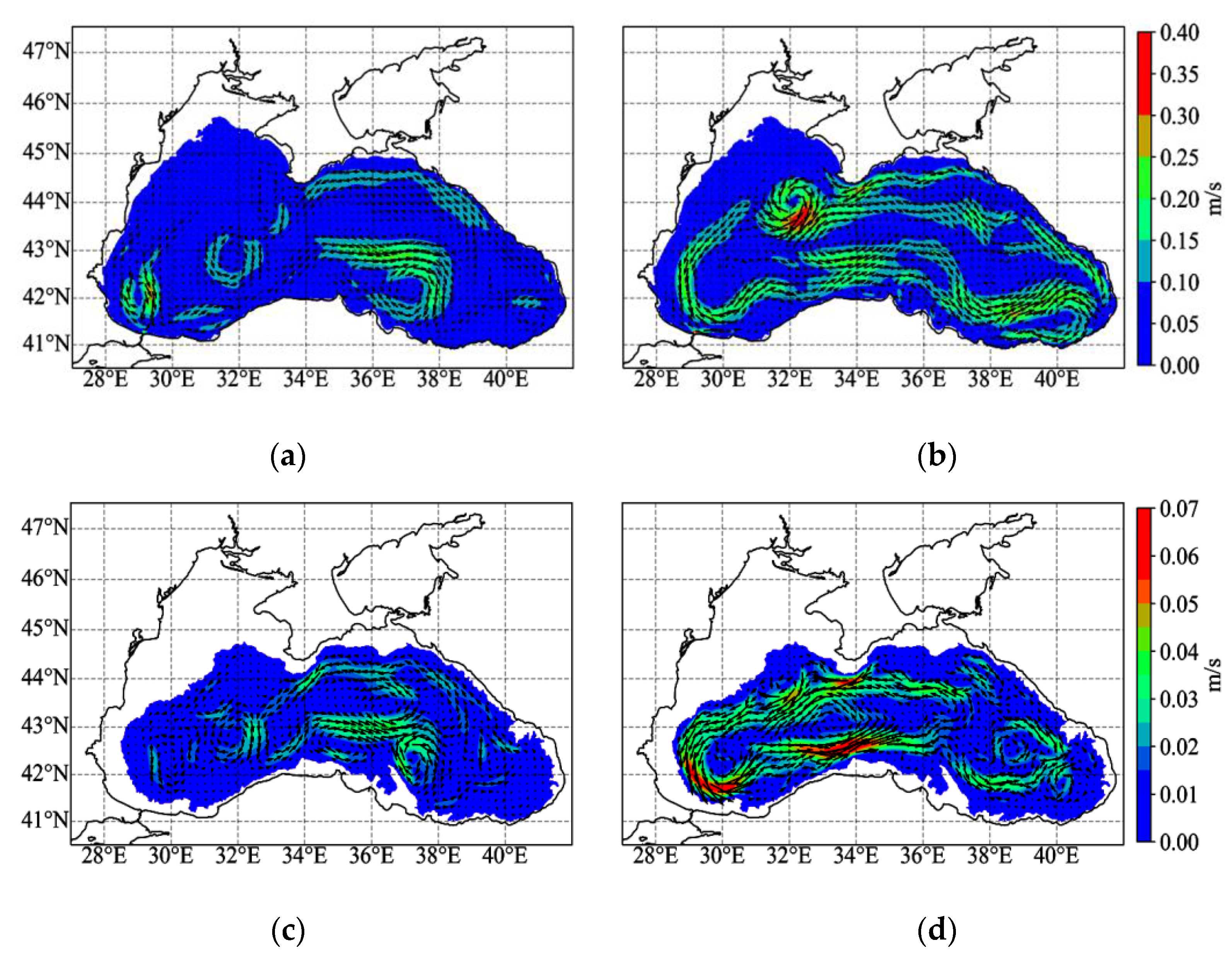
A difference between the simulation results was primarily found in the velocity fields due to the strong influence of the wind on Black Sea dynamics [1,2]. The increasing wind velocity in ERA5 (Figure 1b) led to a more typical structure of the Rim Current at the end of 2016, when the basin-scale cyclonic gyre was propagated above the continental slope (Figure 2b). The Rim Current was not regenerated in winter, and mesoscale eddies were developed in the central sea part in the SKIRON-experiment (Figure 2a) due to insufficient kinetic energy inflow from the wind [8].
The model circulation in the upper layer was generally cyclonic for both experiments. At the same time, the most significant difference of the current velocity fields was detected below the permanent pycnocline core. Thus, at deepwater horizons, in the ERA5-experiment (Figure 2d), the current field was more intense, and maximal velocity was higher than in the SKIRON one (Figure 2c).
Analysis of ARGO float ID6901833 trajectory data [13] revealed a change in the direction of the alongshore subpycnocline current from the northwestern (cyclonic) to the northeastern (anticyclonic) near the northeastern continental slope. Thus, from 6 September to 14 October, 2016 the float drifted anticyclonicaly at its parking depth of 200 m (Figure 3a, red arrows). Such behavior of the alongshore current was not modeled in the SKIRON-experiment (Figure 3b), but was clearly reconstructed in the ERA5-experiment (Figure 3c). Averaged over the period of anticyclonical movement of the float, the model velocity of the undercurrent riches 0.03–0.05 m/s with instant value up to 0.08 m/s. The undercurrent generation near the Black Sea continental slope is probably associated with the intense mesoscale variability under the permanent pycnocline in the ERA5-experiment (Figure 3c). Here, some eddies were observed along the continental slope. The undercurrents that form near the northeastern slope of the Black Sea seem to be of an anticyclonic nature, similar to the undercurrents formed by anticyclones in the western part of the Bay of Bengal [15].
The structure of the circulation is inextricably linked with the spatiotemporal variability of seawater thermohaline characteristics [3,7]. The model temperature and salinity fields on the zonal cross-section along 44°N averaged over the period of existing undercurrent are shown in Figure 4. As seen in temperature fields (Figure 4a,b), the upper mixed layer reached a depth of 20–25 m in both experiments, but in the ERA5-experiment its thickness was larger near the eastern coast (up to 25–30 m), and its temperature was higher here as well. The mesoscale anticyclones shown in Figure 3c led to the deepening of isotherms and isohalines near the eastern coast and the formation of an undercurrent along the slope. There is a downward deflection of the isotherms at zone of 38.3–39.0° N in Figure 4b that corresponds to the anticyclonic current. A similar deflection is also visible in the salinity field (Figure 4d). Thus, the distribution of temperature and salinity in the ERA5-experiment is consistent with the anticyclonic current near the continental slope detected in the ARGO float ID6901833 data [13].

4. Conclusions

The important outcome of the study is that atmospheric fluxes can affect the circulation of both the surface and deepwater layers of the Black Sea, and the choice of atmospheric forcing data can be decisive for the correct modeling of hydrophysical fields in the entire basin. As was determined through numerical analysis, with a significant influence of wind forcing, both the upper layer circulation and the deepwater dynamics in the Black Sea depend on the characteristics of the atmosphere. Despite strong density stratification and difficult vertical exchange with deep layers, the atmospheric forcing also affects the circulation at a horizon of 200 m and deeper. Thus, mesoscale features of the model dynamics near the continental slope, such as subpycnocline undercurrents detected from the ARGO observations in the northeastern part of the sea, appear only when using ERA5 forcing. Additionally, the Black Sea thermohaline structure is more accurately reconstructed under ERA5 forcing, and this was confirmed by the TS-measurement data. Atmospheric fluxes in ERA5 were more likely to be intense compared to SKIRON. Thus, for more accurate modeling of Black Sea circulation and its subsequent application for complex studies, from the two widely used meteorological datasets, the use of ERA5 atmospheric forcing data is recommended rather than SKIRON.

Author Contributions

Conceptualization, O.D. and N.M.; forcing preparation, modeling, validation, and visualization O.D.; hydrophysical analysis, N.M.; writing—original draft preparation, O.D. and N.M.; writing—review and editing, O.D. and N.M. All authors have read and agreed to the published version of the manuscript.

Funding

Numerical simulations and validation of the results were funded by the Russian Science Foundation under Grant 22-77-10056 (https://rscf.ru/en/project/22-77-10056/, accessed on 10 March 2023). Observation data processing was carried out within MHI State assignment on theme № FNNN-2021-0004. Estimation of the atmospheric forcing effect on the Black Sea deepwater circulation was supported by the Russian Science Foundation Grant No. 22-17-00150 (https://rscf.ru/en/project/22-17-00150/ (accessed on 10 March 2023)).

Institutional Review Board Statement

Not applicable.

Informed Consent Statement

Not applicable.

Data Availability Statement

The datasets generated and analyzed during the current study are available from the MHI administration upon reasonable and/or special request.

Acknowledgments

The authors are grateful to the developer of the MHI-model, Demyshev S.G., for the opportunity to use the model in the experiments.

Conflicts of Interest

The authors declare no conflict of interest.

References

  1. Capet, A.; Barth, A.; Beckers, J.-M.; Marilaure, G. Interannual variability of Black Sea’s hydrodynamics and connection to atmospheric patterns. Deep Sea Res. II 2012, 77–80, 128–142. [Google Scholar] [CrossRef] [Green Version]
  2. Kubryakov, A.A.; Stanichny, S.V.; Zatsepin, A.G.; Kremenetskiy, V.V. Long-term variations of the Black Sea dynamics and their impact on the marine ecosystem. J. Mar. Syst. 2016, 163, 80–94. [Google Scholar] [CrossRef]
  3. Ivanov, V.A.; Belokopytov, V.N. Oceanography of the Black Sea; ECOSY-Gidrofizika: Sevastopol, Ukraine, 2013; pp. 65–71. [Google Scholar]
  4. Zatsepin, A.G.; Korzh, A.O.; Kremenetskii, V.V.; Ostrovskii, A.G.; Poyarkov, S.G.; Solov’ev, D.M. Studies of the hydrophysical processes over the shelf and upper part of the continental slope of the Black Sea with the use of traditional and new observation techniques. Oceanology 2008, 48, 466–475. [Google Scholar] [CrossRef]
  5. Korotenko, K.; Osadchiev, A.; Melnikov, V. Mesoscale Eddies in the Black Sea and Their Impact on River Plumes: Numerical Modeling and Satellite Observations. Remote Sens. 2022, 14, 4149. [Google Scholar] [CrossRef]
  6. Demyshev, S.G.; Dymova, O.A.; Markova, N.V.; Korshenko, E.A.; Senderov, M.V.; Turko, N.A.; Ushakov, K.V. Undercurrents in the northeastern Black Sea detected on the basis of multi-model experiments and observations. J. Mar. Sci. Eng. 2021, 9, 933. [Google Scholar] [CrossRef]
  7. Staneva, J.V.; Dietrich, D.E.; Stanev, E.V.; Bowman, M.J. Rim current and coastal eddy mechanisms in an eddy-resolving Black Sea general circulation model. J. Mar. Syst. 2001, 31, 137–157. [Google Scholar] [CrossRef] [Green Version]
  8. Demyshev, S.G.; Dymova, O.A. Analysis of the annual mean energy cycle of the Black Sea circulation for the climatic, basin-scale and eddy regimes. Ocean Dyn. 2022, 72, 259–278. [Google Scholar] [CrossRef]
  9. European Marine Observation and Data Network (EMODnet). EMODnet Digital Bathymetry (DTM 2020)-Tile D3. Available online: https://emodnet.ec.europa.eu/geonetwork/srv/eng/catalog.search#/metadata/19f800a9-f0fd-4055-b4cd-90ed156dc7fc/ (accessed on 12 March 2023).
  10. Lima, L.; Masina, S.; Ciliberti, S.A.; Peneva, E.L.; Cretí, S.; Stefanizzi, L.; Lecci, R.; Palermo, F.; Coppini, G.; Pinardi, N.; et al. Black Sea Physical Reanalysis (CMEMS BS-Currents) (Version 1) Data Set; Copernicus Monitoring Environment Marine Service (CMEMS), 2020. [Google Scholar] [CrossRef]
  11. Kallos, G.; Nickovic, S.; Papadopoulos, A.; Jovic, D.; Kakaliagou, O.; Misirlis, N.; Boukas, L.; Mimikou, N.; Sakellaridis, G. The regional weather forecasting system SKIRON: An overview. In Proceedings of the International Symposium on Regional Weather Prediction on Parallel Computer Environments, Athens, Greece, 15–17 October 1997; pp. 109–122. [Google Scholar]
  12. Hersbach, H.; Bell, B.; Berrisford, P.; Biavati, G.; Horányi, A.; Muñoz Sabater, J. ERA5 Hourly Data on Single Levels from 1959 to Present; Copernicus Climate Change Service (C3S), Climate Data Store (CDS), 2018. [Google Scholar] [CrossRef]
  13. Coriolis. Available online: https://dataselection.coriolis.eu.org/ (accessed on 12 March 2023).
  14. Artamonov, Y.V.; Skripaleva, E.A.; Alekseev, D.V.; Fedirko, A.V.; Shutov, S.A.; Kolmak, R.V.; Shapovalov, R.O.; Shcherbachenko, S.V. Hydrological Research in the Northern Part of the Black Sea in 2016 (87th, 89th and 91st Cruises of R/V Professor Vodyanitsky). Phys. Oceanogr. 2018, 25, 229–234. [Google Scholar] [CrossRef] [Green Version]
  15. Francis, P.A.; Jithin, A.K.; Chatterjee, A.; Mukherjee, A.; Shankar, D.; Vinayachandran, P.N.; Ramakrishna, S.S.V.S. Structure and dynamics of undercurrents in the western boundary current of the Bay of Bengal. Ocean Dyn. 2020, 70, 387–404. [Google Scholar] [CrossRef]
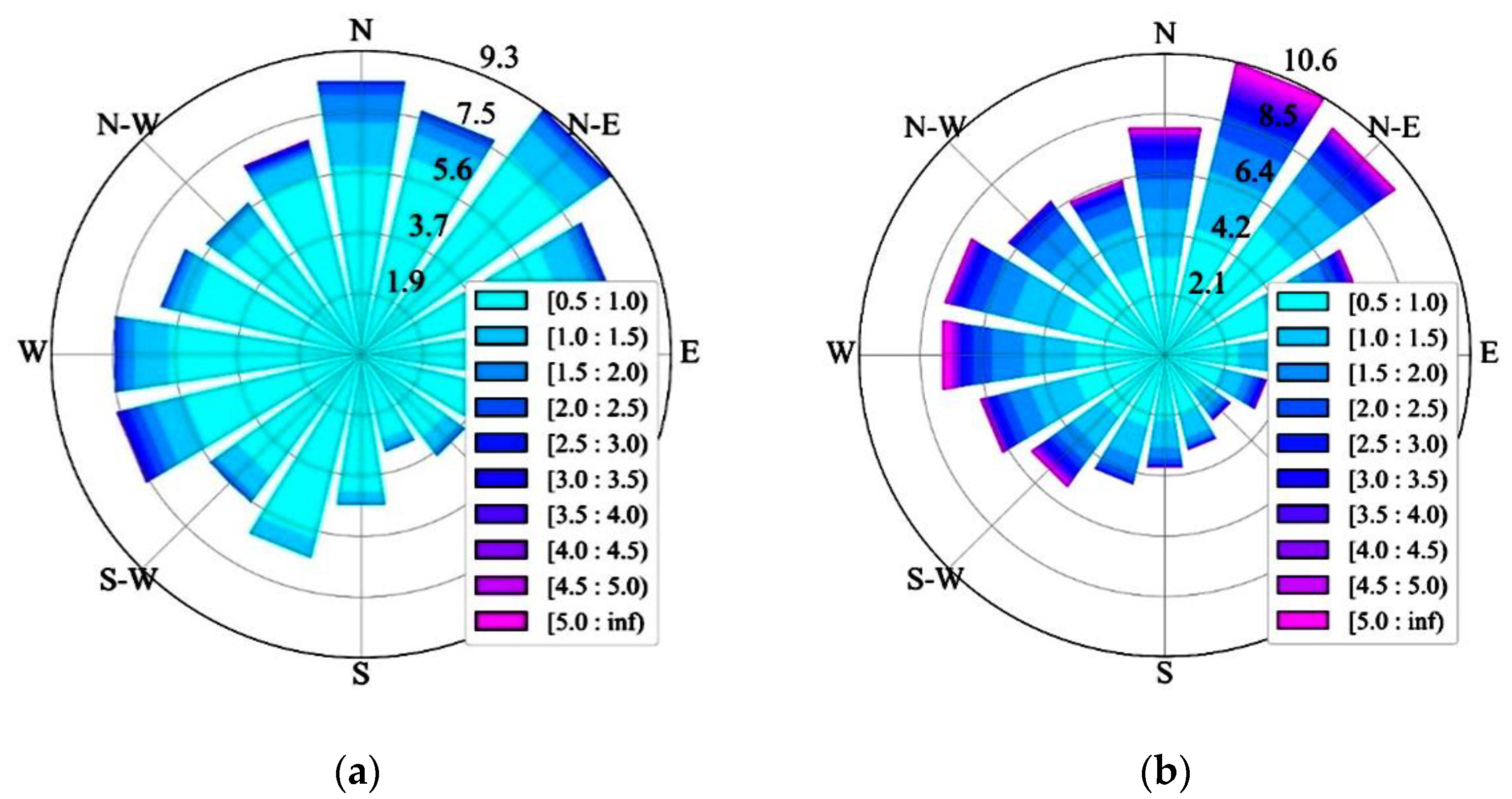
Figure 1. Histograms of the annual mean repeatability of the area-averaged wind directions (digits, %) and wind stress magnitudes (color, 10−5 N/cm2) for the Black Sea area in 2016: (a) by SKIRON; (b) by ERA5. Data were calculated from the wind velocity at a height of 10 m.
Environsciproc 25 00061 g001
Figure 2. Monthly mean current fields in December 2016 at a depth of 50 m (a,b) and at a depth of 500 m (c,d) according to the SKIRON-experiment (a,c) and the ERA5-experiment (b,d).
Environsciproc 25 00061 g002
Figure 3. (a) ARGO float ID6901833 trajectory at parking depth of 200 m. Model current velocity at 200 m time-averaged for 6 September–14 October 2016 by the SKIRON-experiment (b) and the ERA5-experiment (c). Blue arrows illustrate the northwestern alongshore current, red arrows correspond to the southeastern current (undercurrent).
Environsciproc 25 00061 g003
Figure 4. Zonal cross-section along 44° N of the model temperature (a,b) and salinity (c,d) fields time-averaged for 6 September–14 October 2016 by the SKIRON-experiment (a,c) and the ERA5-experiment (b,d).
Environsciproc 25 00061 g004
Table 1. The temperature and salinity RMSE between simulations and in situ.
Depth, mTemperature, °CSalinity, psu
SKIRONERA5SKIRONERA5
0–51.1750.6250.2240.258
5–302.3901.7060.1880.212
30–1000.6230.4890.4540.384
100–3000.1990.1540.4230.312
300–8000.0360.0550.0720.084
800–15000.0300.0270.0550.075
Disclaimer/Publisher’s Note: The statements, opinions and data contained in all publications are solely those of the individual author(s) and contributor(s) and not of MDPI and/or the editor(s). MDPI and/or the editor(s) disclaim responsibility for any injury to people or property resulting from any ideas, methods, instructions or products referred to in the content.