Proceeding Paper

Utilization of a Telemetry Monitoring System for the Dynamics of Water Quantity and Quality in the Dadahup Swamp Irrigation Area †

Directorate General Water Resources, Ministry of Public Work and Housing, Jakarta 12110, Indonesia
Presented at the 7th International Electronic Conference on Water Sciences, 15–30 March 2023; Available online: https://ecws-7.sciforum.net.
Environ. Sci. Proc. 2023, 25(1), 41; https://doi.org/10.3390/ECWS-7-14191
Published: 14 March 2023
(This article belongs to the Proceedings of The 7th International Electronic Conference on Water Sciences)

Abstract

:
One of the technological developments supporting irrigation modernization is the installation of telemetry monitoring systems that are built based on three main elements of sensors, internet connections, and data centers. The Dadahup Swamp Irrigation Area is one of the development areas that has been supported by the installation of a telemetry monitoring system at three points located on the upstream and midstream sides of the irrigation area. The water management system of the Dadahup Swamp Irrigation Area has not been working optimally in regulating the water level, which has resulted in the irrigated land not receiving good water quality for rice plant growth. The research objective is to describe the condition of the water quantity and quality profile based on the telemetry monitoring system. The research method was carried out by observing the water level elevation, rainfall, and pH, during the rainy and dry seasons in the upstream, midstream, and downstream parts. The results showed that the dynamics of the water quantity greatly affected the water quality in both the rainy and dry seasons.

1. Introduction

The food estate development program is one of the Government’s efforts to anticipate a food crisis due to the significant increase in population in recent years [1]. One of the efforts to develop food land into agricultural cultivation is the rehabilitation and improvement of the Dadahup Swamp Irrigation Area network with a potential area of ±21,226 thousand ha in Kapuas Regency, Central Kalimantan Province [2].
Due to the extreme seasonal changes, the Dadahup Swamp Irrigation Area is often flooded, resulting in crop failure [3]. The condition of the channel network system and the irrigation buildings that are not functioning optimally along with the broken and collapsed embankments around the irrigation area has resulted in the conversion of the area into shrubland [4].
The development of technology that supports the polder water system is the installation of the internet of things (IOT) which consists of sensors, internet connections, and data centers [5]. The installation of a telemetry monitoring system in the Dadahup Swamp Irrigation Area aims to observe changes in the water quantity and quality in the upstream and midstream of the main primary channel in order to optimize the operation and maintenance of the irrigation networks and buildings [6].

2. Material and Methods
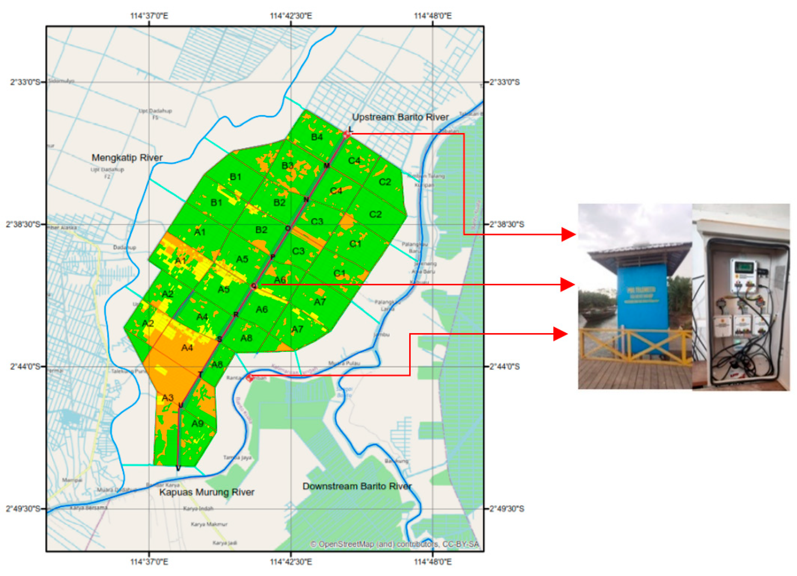
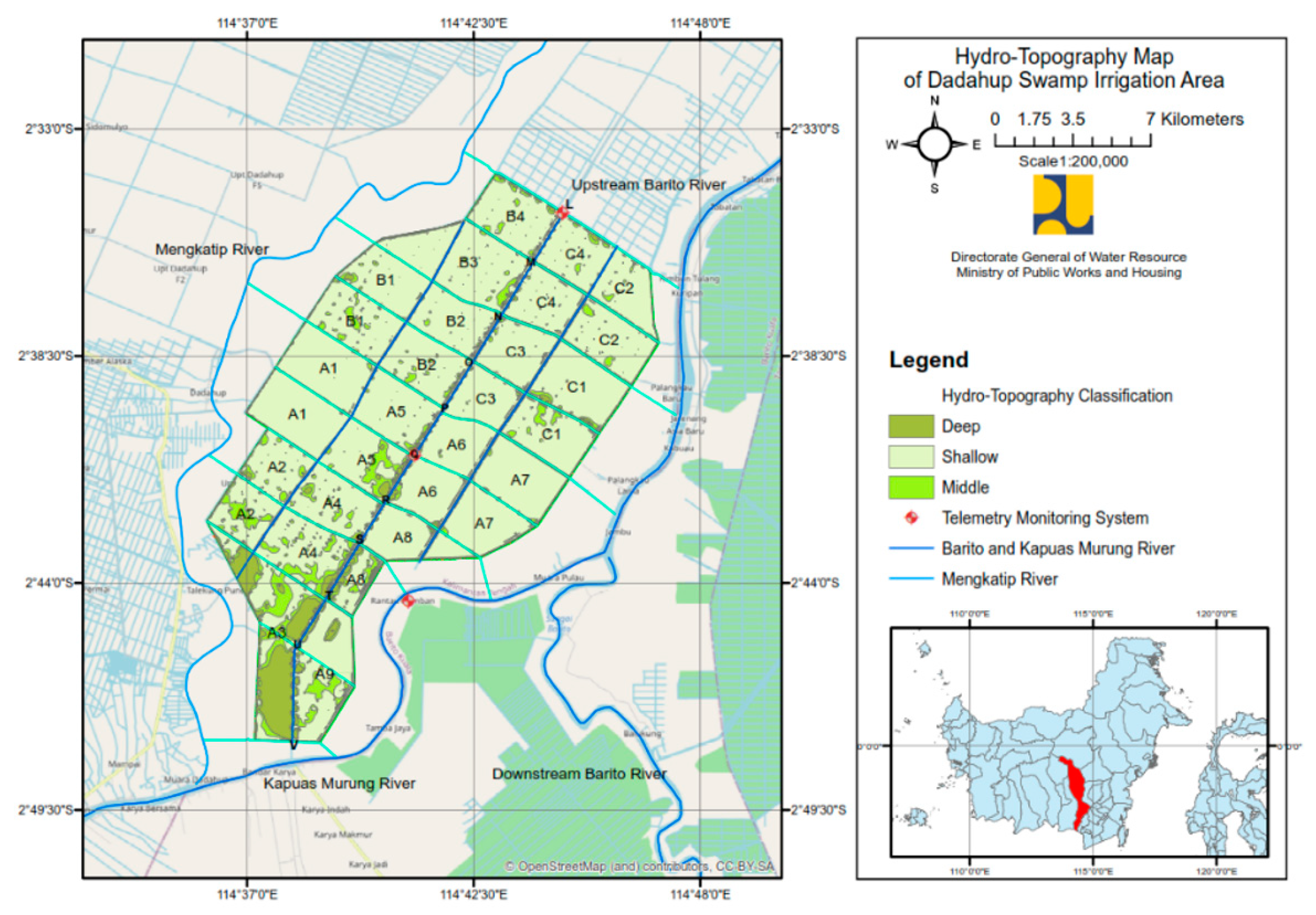
2.1. Study Area

The research site is located in the Dadahup Swamp Irrigation Area of Kapuas Regency, Central Kalimantan Province, which is traversed by the Barito, Kapuas Murung, and Mengkatip Rivers. The tertiary blocks of the Dadahup Swamp Irrigation Area are divided into seventeen tertiary blocks dominated by shrubs, shown in Figure 1.

2.2. Methods

The research was conducted at point locations L and Q by collecting data on the water level, rainfall, and pH, which were obtained by direct observation through the telemetry monitoring system shown in Figure 2.

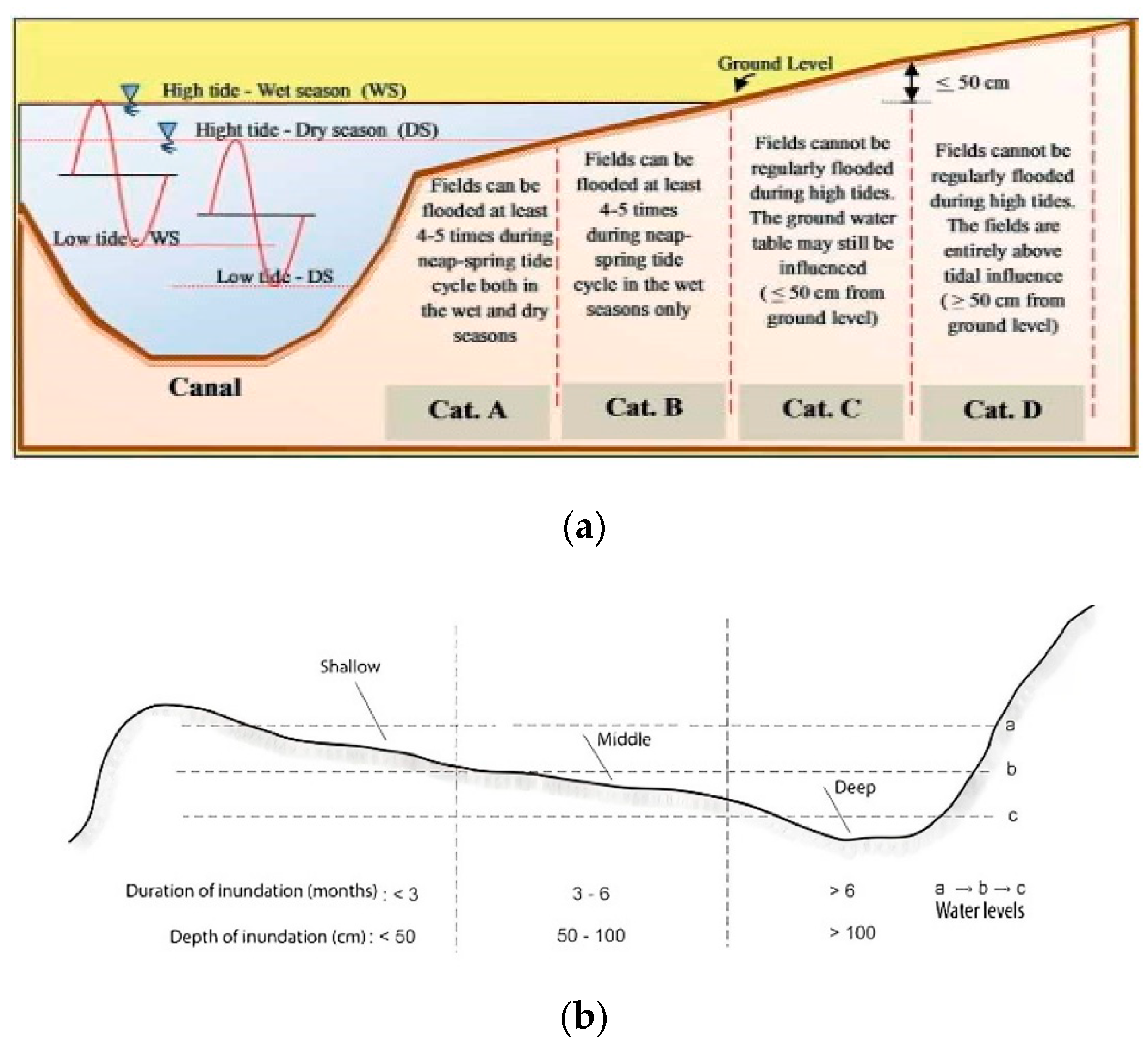
2.3. Characteristics of the Dadahup Swamp Irrigation Area

Hydro-topography is the relationship between the water table elevation and land elevation, which is a factor in determining the classification type of the swamp irrigation areas, as shown in Figure 3 [7]. The Dadahup Swamp Irrigation Area falls into categories C and D, where the tidal water level never inundates the land elevation; so, the main source of water is rainfall, which is included in the nontidal swamp category shown in Figure 4 [8]. The characteristics of the soil, which is dominated by pyrite peat soil, can reduce the water quality and have a negative impact on rice growth [9]. The polder water system is one of the solutions for the development of the Dadahup Swamp Irrigation Area by utilizing rainfall as a water source by isolating the land, which is regulated through the operation of gate buildings in the north, east, west, and south [10].

2.4. Water Quantity and Quality

The tidal influence of the estuary and the upstream discharge of the Barito River can affect the water level at the intake channel of the Dadahup Swamp Irrigation Area with a distance of up to 158 km to the upstream of the river [11]. The Dadahup Irrigation Area is included in the wet category of climate types B and E, where the rainy season occurs from May to October, and the dry season occurs from November to April. The swamp soil characteristics are influenced by the presence of pyrite formed from marine deposits containing organic matter and sulfate-reducing bacteria. The oxidation of pyrite can cause high acidity, which produces sulfuric acid and jarosite minerals that reduce the pH concentration and interfere with plant growth [12].

3. Results and Discussion

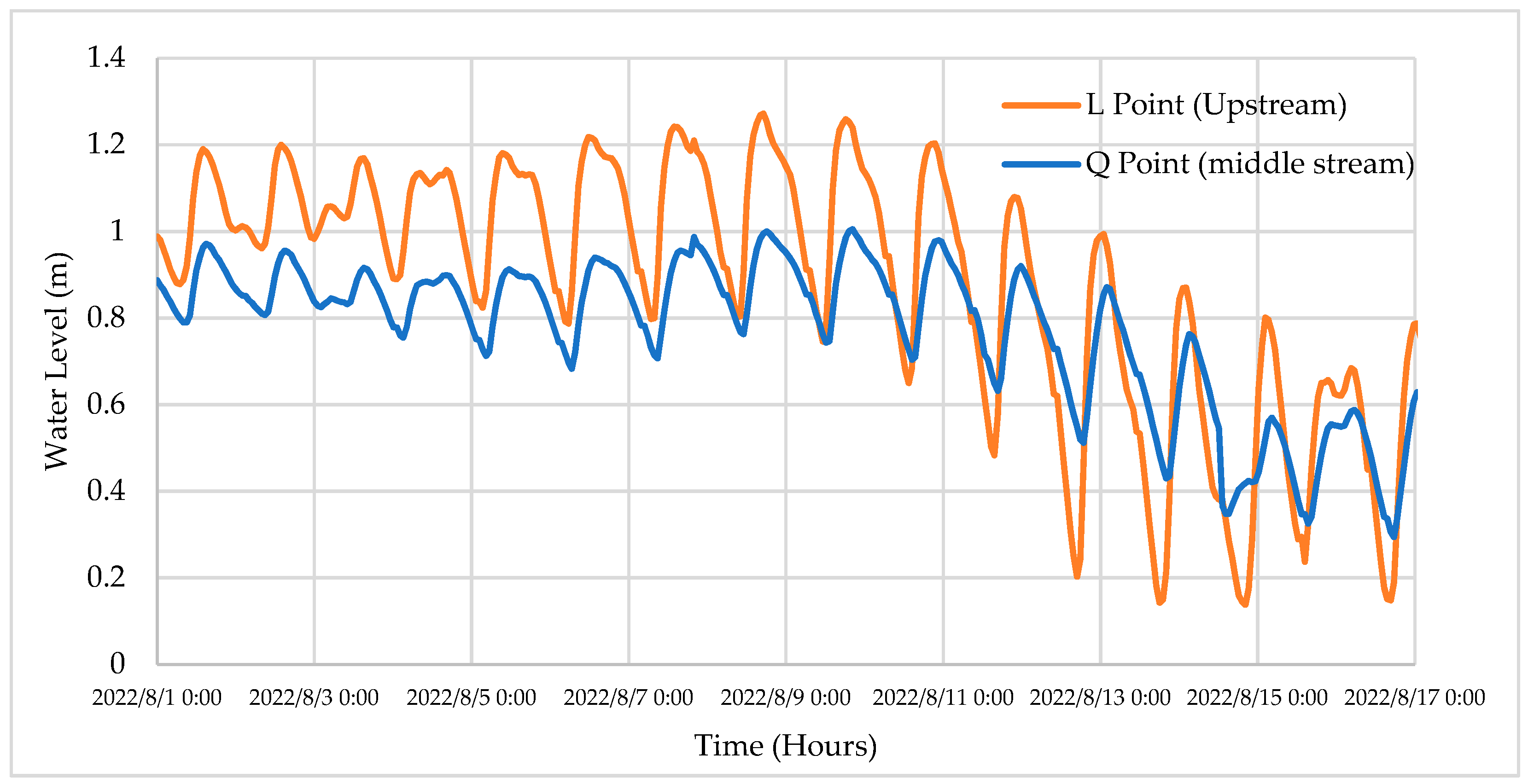
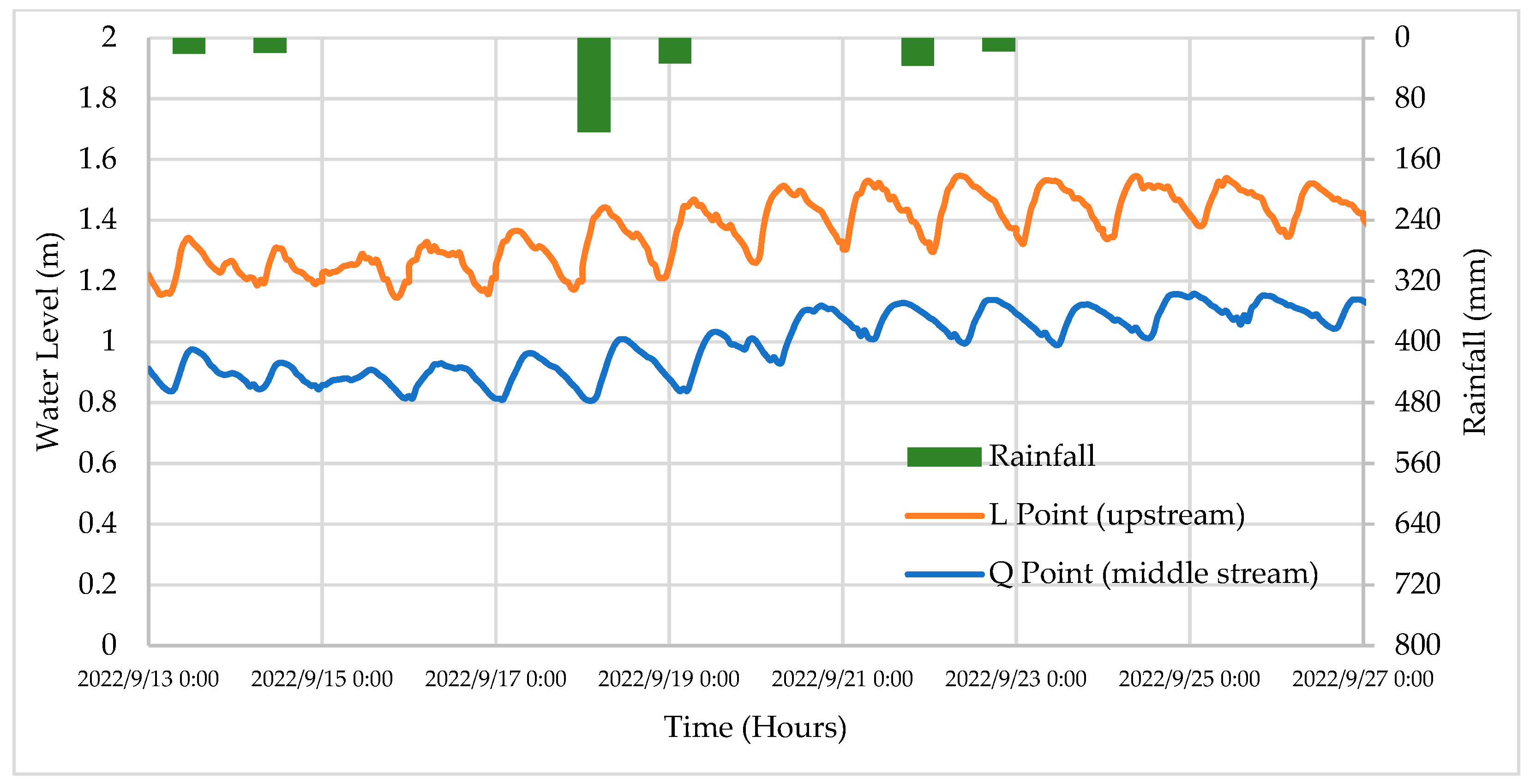
3.1. Water Quantity Dynamics Profile

The dynamics of the water quantity illustrate the profile of the relationship between the rainfall and water level during the dry and wet seasons at points L and Q in the main primary channel shown in Figure 5 and Figure 6.
Based on the results of the description of the dynamic profile of the water level at points L and Q for the dry season and the rainy season, there was a change in the water level elevation influenced by the rainfall with an average increase of 0.3 m, which is shown in Table 1.

3.2. Water Quality Dynamics Profile

The water quality dynamics illustrate the relationship profile of the pH during the dry and wet seasons. The results of the water quality dynamics profile at point L upstream and point Q midstream of the Dadahup Swamp Irrigation Area during the dry and wet seasons are shown in Figure 7 and Figure 8.
Based on the results of the description of the dynamic profile of the water quality, there was a change in the pH value influenced by the rainfall with an average increase reaching level 3, which is shown in Table 2.

4. Conclusions

The results explained that the pH value and water level elevation increased as a result of the rainfall and became the basis for optimizing the operation and maintenance of the Dadahup Irrigation network by utilizing a telemetry monitoring system.

Author Contributions

Conceptualization, A.Z.; methodology, A.Z.; formal analysis, A.Z.; investigation, A.Z.; resources, A.Z.; data acuration, A.Z.; writing—original draft preparation, A.Z.; writing—review and editing, A.Z.; visualization, A.Z.; supervision, A.Z.; project administration, A.Z.; funding acquisition, A.Z. All authors have read and agreed to the published version of the manuscript.

Funding

This research was supported by Directorate General of Water Resources Ministry of Public Works and Housing and Department of Civil Engineering and Environmental Engineering, Faculty of Engineering, Universitas Gadjah Mada, Yogyakarta.

Institutional Review Board Statement

Not applicable.

Informed Consent Statement

Not applicable.

Data Availability Statement

Data are available from corresponding author.

Acknowledgments

The author would like to thank all those who have supported the completion of this paper.

Conflicts of Interest

The author declares no conflict of interest.

References

  1. Santosa, E. Percepatan Pengembangan Food Estate Untuk Meningkatkan Ketahanan Dan Kemandirian Pangan Nasional. Risal. Kebijak. Pertan. DAN Lingkung. Rumusan Kaji. Strateg. Bid. Pertan. dan Lingkung. 2015, 1, 80. [Google Scholar] [CrossRef]
  2. Arif, M.I.; Legono, D.; Luknanto, D. Study on the Performance of the Hydraulics System Planning of Swampy Irrigation Area of Dadahup, Kapuas District, Central Kalimantan Province. IOP Conf. Ser. Earth Environ. Sci. 2021, 930, 1–10. [Google Scholar] [CrossRef]
  3. Arif, M.I.; Legono, D.; Luknanto, D.; Wignyosukarto, B.; Marpaung, M.F. Behavior of Flow of Channel Network of Dadahup Swampy Irrigation Area. In IOP Conference Series: Earth and Environmental Science; IOP Publishing: Bristol, UK, 2022; Volume 1091, p. 012035. [Google Scholar] [CrossRef]
  4. PT. Virama Karya Persero (KSO) Cabang Semarang – PT. Wiratman – PT. Archiegama Bangun Cipta Pratama. Laporan Akhir Survey Investigasi Desain (SID) Rehabilitasi dan Peningkatan Jaringan Irigasi Rawa Wilayah Kerja Blok A; Kalimantan II River Basin Center Palangka Raya at the Directorate General of Water Resources: Palangka Raya, Indonesia, 2020. [Google Scholar]
  5. Setiadi, D.; Muhaemin, M.N.A. Penerapan Internet of Things (IoT) Pada Sistem Monitoring Irigasi (SMART IRIGASI). J. Infotronik 2018, 2, 95–98. [Google Scholar] [CrossRef]
  6. Zevri, A.; Rahardjo, A.P.; Legono, D. Swamp Water Parameter Dynamics Induced by Rainfall and Tides in Dadahup Irrigation Area, Kalimantan. In IOP Conference Series: Earth and Environmental Science; IOP Publishing: Bristol, UK, 2022; pp. 1–10. [Google Scholar] [CrossRef]
  7. Istianto, H.; Bernard, R.; Suryadi, F.X. Improving the performance of tidal irrigation through the water management, (study case gandus Palembang, South Sumatra). In Proceedings–International Association for Hydro-Environment Engineering and Research (IAHR)-Asia Pacific Division (APD) Congress: Multi-Perspective Water for Sustainable Development, IAHR-APD 2018; Curran Associates, Inc.: Red Hook, NY, USA, 2018; Volume 1, pp. 677–685. [Google Scholar]
  8. Wignyosukarto, B.S. Konsep Pengembangan Pola Tata Air Lahan Gambut. Forum Tek. 2000, 24, 342–357. [Google Scholar]
  9. Purboseno, S.; Suparyanto, T.; Hidayat, A.A.; Pardamean, B. A Hydrodynamic Analysis of Water System in Dadahup Swamp Irrigation Area. In Proceedings of the 2021 1st International Conference on Computer Science and Artificial Intelligence (ICCSAI), Jakarta, Indonesia, 28 October 2021; pp. 400–406. [Google Scholar] [CrossRef]
  10. Noor, M.; Anwar, K.; Kartiwa, B. Sistem Polder untuk Pengembangan Pertanian Berkelanjutan di Lahan Rawa Lebak; IAARD PRESS: Kota Bogor, Indonesia, 2017; pp. 22–38. [Google Scholar]
  11. Suriadikarta, D.A. Teknologi Pengelolaan Lahan Rawa Berkelanjutan: Studi Kasus Kawasan Ex PLG Kalimantan Tengah. J. Sumberd. Lahan 2012, 6, 45–54. [Google Scholar]
  12. Blunden, B.; Indraratna, B. Pyrite Oxidation Model for Assessing Ground-Water Management Strategies in Acid Sulfate Soils. J. Geotech. Geoenviron. Eng. 2001, 127, 146–157. [Google Scholar] [CrossRef]
Figure 1. Study Area.
Environsciproc 25 00041 g001
Figure 2. The Dadahup Swamp Irrigation Monitoring Telemetry System.
Environsciproc 25 00041 g002
Figure 3. (a) Tidal Swamp Hydro-topography and (b) Nontidal Swamp Hydro-topography.
Environsciproc 25 00041 g003
Figure 4. Hydro-topography Map of the Dadahup Swamp Irrigation Area.
Environsciproc 25 00041 g004
Figure 5. Water Level Dynamics Profile in the Dry Season in the Upper and Middle Sections of the Dadahup Swamp Irrigation Area.
Environsciproc 25 00041 g005
Figure 6. Water Level Dynamics Profile in the Rainy Season in the Upper and Middle Sections of the Dadahup Swamp Irrigation Area.
Environsciproc 25 00041 g006
Figure 7. Water Quality Dynamics Profile in the Dry Season in the Upper and Middle Sections of the Dadahup Swamp Irrigation Area.
Environsciproc 25 00041 g007
Figure 8. Water Quality Dynamics Profile in the Rainy Season in the Upper and Middle Sections of the Dadahup Swamp Irrigation Area.
Environsciproc 25 00041 g008
Table 1. Changes in the Water Level during the Dry and Rainy Seasons at Points L and Q.
NoPointSeasonWater Level (m)
1L Dry1.2
2Q0.9
3L Rainy1.5
4Q1.2
Table 2. Changes in the pH Values during the Dry and Rainy Seasons in the Upper and Middle Sections of the Dadahup Irrigation Area.
NoPointSeasonpH
1LDry3.91
2Q3.07
3LRainy5.84
4Q5.48
Disclaimer/Publisher’s Note: The statements, opinions and data contained in all publications are solely those of the individual author(s) and contributor(s) and not of MDPI and/or the editor(s). MDPI and/or the editor(s) disclaim responsibility for any injury to people or property resulting from any ideas, methods, instructions or products referred to in the content.

