Abstract
With climate change, dry periods are more frequent, and intense short rainfall events are increasing in Mediterranean areas. It is essential to have better and more accurate territorial planning that does not expose the population to risks. The feasibility of small dams’ construction was studied in the municipality of Guarda to improve and include the information in the respective Master Plan. This paper presents the methodologies implemented and results obtained in the identification of sites for the possible construction of hydraulic structures of less than 15 m height to retain and store water.
1. Introduction
As we know, life without water is impossible. As a consequence, the need for water sources, water supply systems, and flood control the problem of water scarcity have always led to the need for the development of water resource planning with more or less sophisticated equipment and methods.
Nowadays, climate change is responsible for the increase in time duration and number of occurrences of droughts, causing a decrease in the average runoff of watercourses, which can lead to severe situations of water scarcity [1,2]. These conditions highlight the urgent need to strengthen the relationship between urban planning and water resource management by betting on more sustainable and resilient communities. Climate change is reaching a proportion that has implications on the economic growth both on a global scale and on the country scale. In Portugal, since the end of the 1960s, there has been a very sharp decrease in precipitation in January, February, and March which has had serious consequences in various socioeconomic sectors, particularly in sectors where water is an essential good, such as agriculture [3]. So, a new approach in policy and strategy of land occupation is necessary, seeking a new paradigm of water management in the urban environment that should be based, as much as possible, on the combination of structural and non-structural measures. The last one can be based on the re-naturalization of watercourses, implementation of measures aimed at restoring natural retention as much as possible, preserving the still existing flood areas, and complementing them with retention and detention works.
This article summarizes the procedures and techniques used in the identification and evaluation of new surface water reservoirs, within the scope of urban planning and water resources, with a multi-objective function-based approach, cost–benefit analysis, and conflict resolution applied to the city of Guarda, in Portugal.
2. Study Objectives
The main objective of the study presented here was the identification of possible sites for the construction of hydraulic structures for water retention and storage and delimitation of the flood plain inside Guarda city. Urban land occupation, coupled with inadequate spatial planning and drainage system planning, generally induces an increase in flow, due to the increase of impervious areas, which, in turn, increase the frequency and magnitude of floods, as well. The increase of impervious areas in the municipality of Guarda in the last decades has been excessive (similar to the rest of the Country), prompting flood events in frequencies and amplitudes. This fact has forced local authorities to increasingly invest in drainage works, which has not solved problems though; on the contrary, such investments have moved problems elsewhere, typically to downstream locations.
3. Characterization of Watersheds and Streams
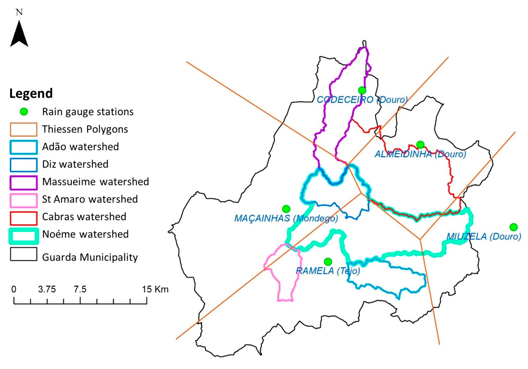
Considering a first phase in which the purpose is to evaluate water availability within the Guarda municipality, all the influential draining basins were delimited for the urban perimeter: Rio Diz, Ribeira das Cabras, Rio Noéme, Ribeira de Adão, Ribeira de Santo Amaro, and Rio Massueime, which were characterized into geometric, physiographic, topography, drainage, and occupation. For the streams above, records of precipitation and flow, when available, were analyzed; in each associate basin, maximum flow and corresponding recurrence periods were quantified.
Based on cartographic, bathymetric, and urban topographic information, hydrological–hydraulic models were built which allowed for the evaluation of the influence of extreme values in the definition of urban perimeters.
Based on hydrological models, the water availability of each stream was estimated.
Figure 1a shows a map with the location of Guarda municipality within the Country, and Figure 1b shows a map with the location of the studied basins in the municipality of Guarda. As can be seen, the streams under analysis have their origin very close to each other; hence, they are very similar from the geomorphological point of view.
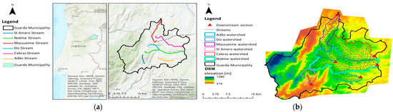
Figure 1.
(a) Location of Guarda municipality and streams under study. (b) Elevation map of Guarda municipality and location of the basins under study.
As an example of what was performed for all basins, Figure 2 illustrates the physical characterization of the basin of River Diz, namely the delimitation of the hydrographic basin, the slope map, the hypsometric curve, and the hydrodynamic curve.
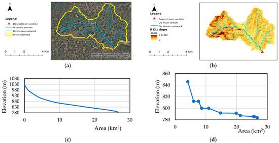
Figure 2.
(a) Land-occupation map and basin streams. (b) Slopes map of Diz basin. (c) Hypsometric curve of Diz Stream Basin. (d) Hydrodynamic curve of Diz Stream basin.
Table 1 summarizes some of the characteristics of the studied watersheds.

Table 1.
Characteristics of the watersheds.
The study of precipitation in a given river basin is based on rainfall records at different udometric points in or near the basin. Overall, the more collection points and the greater the number of years recorded, the more rigorous the study will be.
In the present study, data were collected from national public databases. These databases are available from the Portuguese Environmental Agency (APA) through the National Water Resources Information Service (SNIRH) platform [4]. The selected data correspond to a period of 12 years, between 1984 and 1996.
For the calculation of the average precipitation in a watershed, we can use several methods, such as the arithmetic mean method, the Thiessen method, or the isohyetal method; among them, the most commonly used one is Thiessen method [5].
Because of the lack of udometric stations in the hydrographic basins under study, it was necessary to use stations located in neighboring river basins, using the Thiessen method. This is exemplified in Figure 3, where, to obtain the weighted monthly precipitation in the basin under study, the following general equation was used (1):

Figure 3.
Application of the Thiessen method.
The study of monthly and annual flows is essential for assessing the water availability of water lines in the analysis. The quantification of the maximum flows for the different return periods is necessary for the assessment of flooded areas and their impacts.
The instantaneous maximum flows can be obtained by studying either the records of the values of hydrometric stations located in the basin or by using formulas or methods of transformation of precipitation into runoff. Due to the short time series of maximum flows, the two methodologies were used, namely statistical methods such as Gumbel’s law, and the rational method, the most widely used rainfall–runoff method, to obtain maximum flow [6].
The use of methods of transformation of precipitation into flow requires the knowledge of precipitation values with different periods of recurrence, being usual the use of intensity–duration–frequency curves (IDF curves).
In view of the absence of IDF curves for high-recurrence periods, located in the basins under study, IDF curves with some geographical proximities were used, and an interpolation was developed in order to “quantify” the influence of the elevation effect on precipitation values. Peak flows with a return period from 10 years to 1000 years were computed. The peak flow with a 100-year return period varies between approximately 105 m3/s in River Noeme and 40 m3/s in River St. Amaro.
Moreover, as a consequence of lack of flow records, Equation (2) was used to estimate monthly flows. The estimated flow value is a function of the flow recorded in a given stream, with characteristics identical to those of the basin under study, affected by a relationship of the areas and precipitations of the basins considered for the study:
Based on the methodologies described above, monthly precipitations and monthly flows were computed. Consequently, annual values were obtained, and this allowed us to perform an evaluation of the respective water availability. These values are summarized in Table 2.
Table 2.
Average flows and annual runoff in the sections of the streams under study.
4. Flood Plains
One of the goals of the study was also the delineation of the flood plain inside Guarda city. For the hydraulic simulation, in view of delimitation of the flooded areas associated with the location of different dams, we used the hydraulic model HEC-RAS (Hydrological Engineering Center-River Analysis System) [7], which is a free-use model (“Open-Access”) developed by the US Army Corps of Engineers. This model is a one-dimensional model that solves complete Saint–Venant equations by applying the finite differences method, allowing us to simulate free surface flow in steady and unsteady regimes.
In the HEC-RAS model simulations, the topography of the canal is characterized by the digital elevation model (DEM) developed by using 1:10,000 scale data provided by Guarda City Council, which allows us to define a series of cross-sections along the length of the watercourse under study. For planning purpose, such as this study, this information is adequate [8]. However, for a detailed design, a more accurate topographic survey may be necessary. After the simulation of the model, the water heights in the mentioned cross-sections are calculated, thus enabling the delimitation of the flooded area.
Since the free surface dimension is constant throughout the section, the flooded area is limited by intersecting the DEM with the free surface in each section and the result of the interpolation between the profiles of the cross-sections.
The calibration of the model generated was made by adjusting the characteristic parameters of the model presented above.
After visiting the site and taking into account existing cartography, it was possible to apply several values tabled in the specialized bibliography. The results that were obtained were compared with different calculation methods.
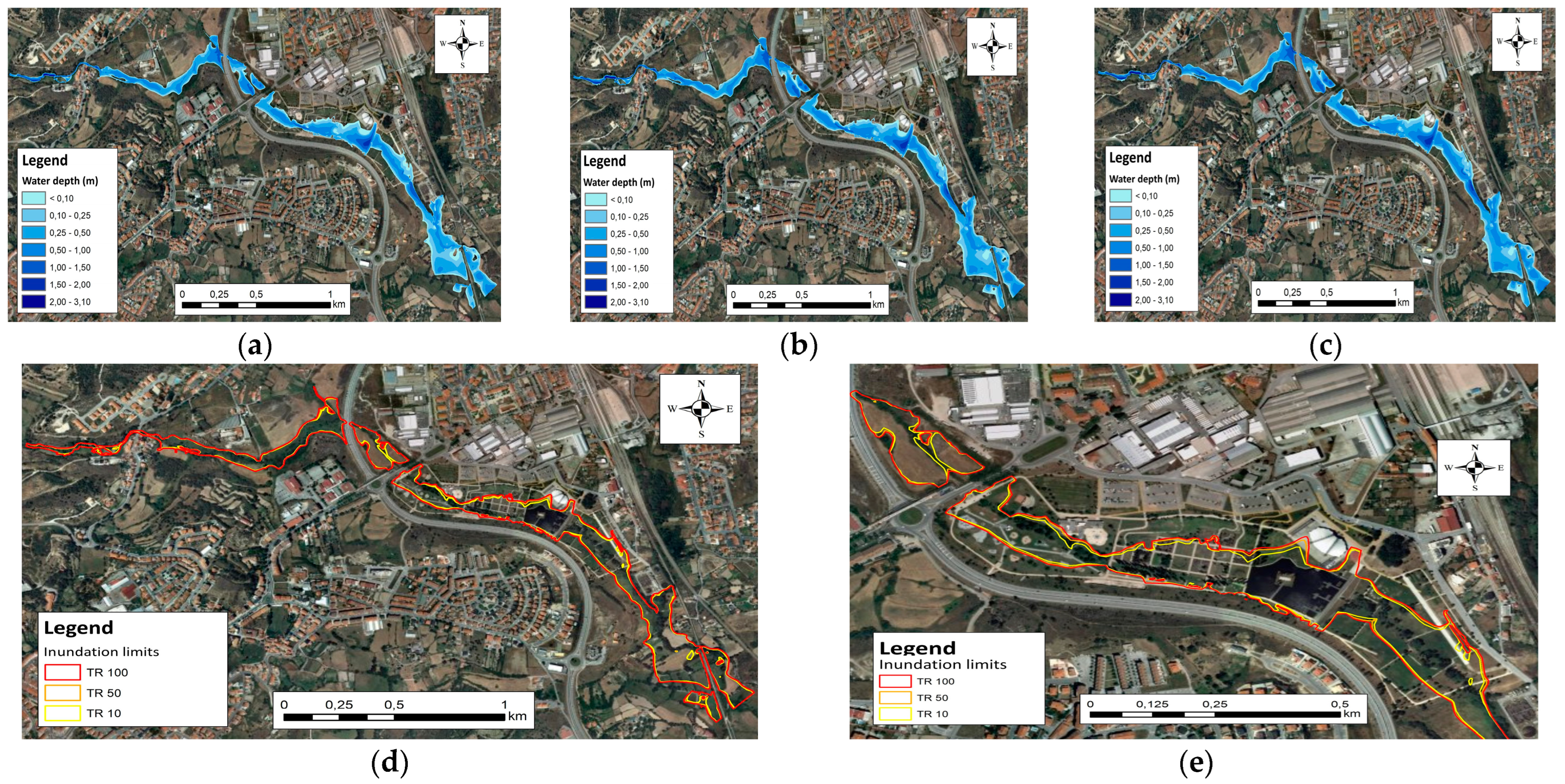
Different flow-rate simulations with a recurrence time (TR) of 10, 50, and 100 years and durations (tp) higher than the concentration time of the basin (tc) were performed. The flood-plain maps associated with peak discharges for these different return periods are presented in Figure 4a–e.

Figure 4.
(a) Flood-plain map for peak discharge with a 10-year return period (TR). (b) Flood-plain map for peak discharge with a 50-year return period (TR). (c) Flood-plain map for peak discharge with a 100-year return period (TR). (d) Flood-plain limits for peak discharge with different return periods. (e) Flood-plain limits for peak discharge with different return periods in the Guarda Polis zone.
5. Reservoir Locations and Storage Capacity
The reservoir location and storage capacity were evaluated in the Rivers Diz, Adão, Cabras, Noéme, Santo Amaro, and Massueime.
To decrease the environmental impact, and due to legal requirements, dam heights up to 12 m were considered.
As a result, possible site locations are those located in Cabras and Adão streams and in Massueime and Santo Amaro streams.
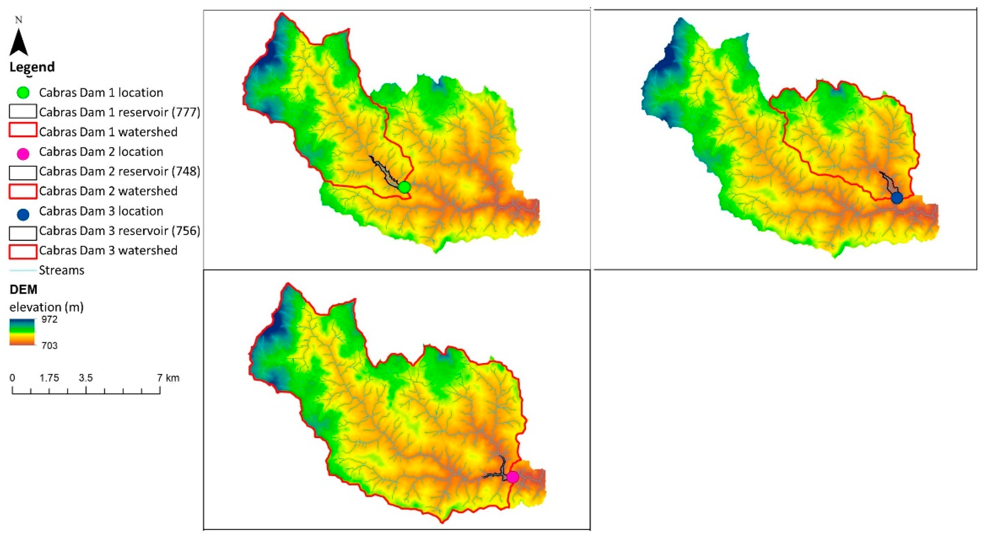
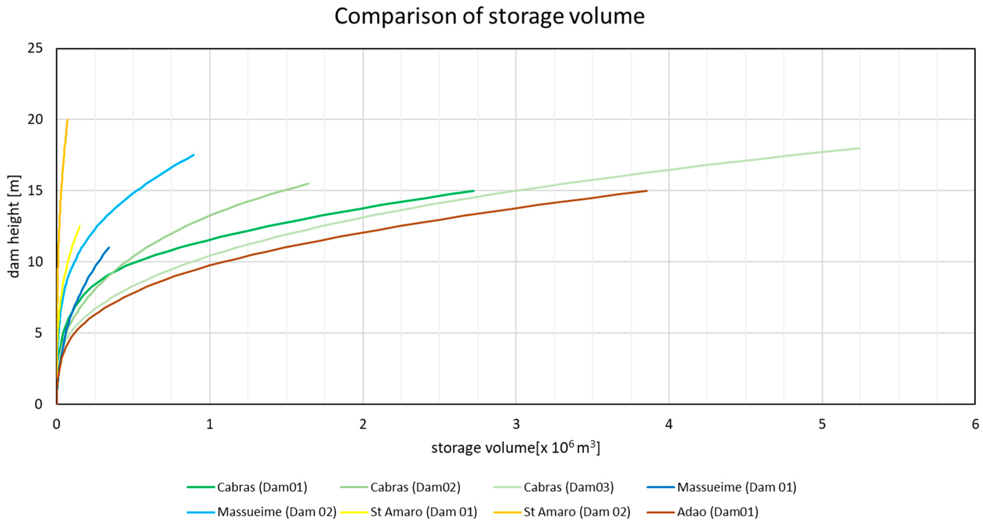
Figure 5 shows the location of three of the eight different dams that were identified in our study as likely to be implanted, and Figure 6 presents the relation between the dam height and its potential storage capacity. As it can be seen, the storage volume is much higher for dams in the River Adão and River Cabras: for the same dam wall height, more than 1 × 10⁶ m3 of water can be stored.
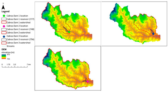
Figure 5.
Possible location of dams in Cabras stream.
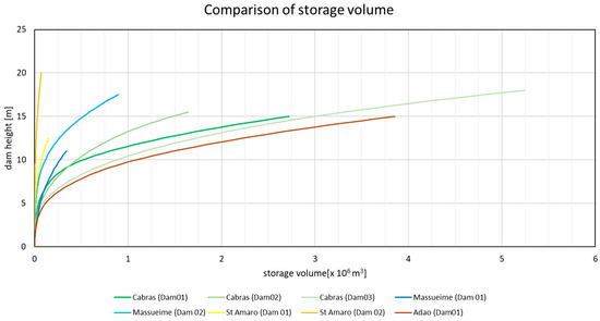
Figure 6.
Storage-capacity analysis.
6. Conclusions
The urban population has been increasing, and it is expected that, by 2030, about 60% of the world’s population will live in urban areas. As a consequence, important and significant impacts are to be expected in basic sanitation systems and, in particular, in drainage systems.
Therefore, with the new knowledge, modeling tools, and risk perception, a change in the design and management practices of urban drainage infrastructures should be implemented in order to develop appropriate and viable solutions.
The feasibility of small dams’ construction was studied in the municipality of Guarda to improve and include the information in the respective Master Plan. Moreover, the flood plain inside Guarda city was delineated, associated to different return periods.
The numerical simulations made allowed us to observe that, for events with higher recurrence periods, even around 100 years, physical and social equipment’s are not affected by the corresponding floods. However, it is recommended to implement a Municipal Urban Drainage Master Plan (MUDMP) consisting of a set of guidelines that determine the management of the drainage system and whose main objective is to minimize the economic, safety, and environmental impact due to the rainwater flow. The MUDMP should schedule all structural and non-structuring measures, include public participation, be defined by urban sub-basins, and be integrated into the Municipal Master Plan.
Regarding possible construction sites of hydraulic structures envisaging water retention and storage, eight potential sites were identified from the analysis performed. Identified site locations should be subject to technical and economic evaluation for the construction of multipurpose uses, and the possible construction of the hydraulic structures mentioned above will imply the preparation of the corresponding Planos de Ordenamento de Albufeiras de Águas Públicas (POAAP) [9].
Author Contributions
A.S.-M., supervision, conceptualization, and methodology; H.-M.S., investigation, formal analysis, writing—original draft, and writing—review and editing; J.-P.d.A., investigation, formal analysis, writing—original draft, and writing—review and editing; N.-E.S., investigation, formal analysis, writing—original draft, and writing—review and editing. All authors have read and agreed to the published version of the manuscript.
Funding
This research received no external funding.
Acknowledgments
The authors acknowledge the support of ACIV and the data provided by the Guarda Municipality.
Conflicts of Interest
The authors declare no conflict of interest.
References
- Garcıa-Ruiz, J.; Lopez-Moreno, J.; Vicente-Serrano, S.M.; Lasanta, T.; Beguería, S. Mediterranean water resources in a global change scenario. Earth-Sci. Rev. 2011, 105, 121–139. [Google Scholar]
- Rocha, J.; Carvalho-Santos, C.; Diogo, P.; Beça, P.; Keizer, J.; Nunes, J. Impacts of climate change on reservoir water availability, quality and irrigation needs in a water scarce Mediterranean region (southern Portugal). Sci. Total Environ. 2020, 736, 139477. [Google Scholar] [CrossRef] [PubMed]
- Santos, F.D. Alterações Climáticas. In Ensaios da Fundação nº111; Fundação Francisco Manuel dos Santos: Lisboa, Portugal, 2021; ISBN 978-989-9064-24-9. [Google Scholar]
- SNIRH: Sistema Nacional de Informação de Recursos Hídricos. Available online: snirh.apambiente.pt (accessed on 1 July 2020).
- Hipólito, J.R.; Vaz, A.C. Hidrologia e Recursos Hídricos; IST Editora Press: Lisboa, Portugal, 2011. [Google Scholar]
- Chow, V.T.; Maidment, L.R.; Mays, L.R. Applied Hydrology; McGraw-Hill: New York, NY, USA, 1988. [Google Scholar]
- Available online: https://www.hec.usace.army.mil/software/hec-ras/ (accessed on 1 July 2020).
- EXCIMAP. Handbook on Good Practices for Flood Mapping in Europe; European Commission, European Environment Agency: Copenhagen, Denmark, 2007. [Google Scholar]
- Planos de Ordenamento de Albufeiras de Águas Públicas (POAAP). Sistema de Informação do Regadio. Available online: sir.dgadr.gov.pt (accessed on 1 July 2020).


Publisher’s Note: MDPI stays neutral with regard to jurisdictional claims in published maps and institutional affiliations. |
© 2022 by the authors. Licensee MDPI, Basel, Switzerland. This article is an open access article distributed under the terms and conditions of the Creative Commons Attribution (CC BY) license (https://creativecommons.org/licenses/by/4.0/).