1. Introduction
Geographical Information Systems (GIS) have become part of all aspects related to territory management, thus revolutionising the way of dealing with spatial information and contributing directly to the dissemination of knowledge, the protection of cultural heritage and the enhancement of educational and tourist offering. This is the context that frames the experimental project developed for Parco Nazionale Circeo, an area protected since 1934 within the Pontine Marshes located in the province of Latina [
1]. The project is aimed at a new form of disseminating knowledge of cultural heritage and enhancing the territory for an innovative tourism strategy.
The model proposed by Tecnostudi Ambiente S.r.l., a partner of the park, consisted in creating an OpenSource Desktop GIS Management system and a WebGIS to provide access to geo-thematic tourist information presented in a concise and appealing way.
This required collecting and organising all available geographical data and allowed, through the use of modern technologies (photos from drone, 3D models and Virtual Tour-VT360°), the implementation of new information on a platform that was created ad hoc for this purpose.
The system is designed to promote tourism through easier access to information, and begins with the recognition of the cultural and environmental resources of the area under examination.
Parco Nazionale Circeo represents an excellent opportunity for the development of a product that meets the needs of quality rural tourism in a unique environment of outstanding natural beauty. The park hosts remarkably rich flora and fauna, and a great variety of environments that offer many options to plan trekking or biking routes, as well as numerous archaeological sites, with traces of human activity dating back to the Middle Palaeolithic, the Roman Age, the Middle Ages up to our present day.
If properly enhanced, the resources of this territory represent an attractive pole to be used throughout the year and not only during the summer when the coastal strip is crowded with thousands of tourists, and offer an alternative linked to sustainable tourism, which is seasonally adjustable.
2. Geodatabase Opensource
The data collected made it possible to create a geographical database capable of providing concrete technical, logistical and practical support to that part of local authorities that aims to encourage tourism in rural areas.
Knowing the actual size and status of the environmental and archaeological heritage has several advantages such as:
facilitating work scheduling;
optimising the activities related to park management;
monitoring and documenting all the activities carried out, spatially and diachronically;
it provides an excellent tool for the census taking of archaeological evidence (which can be assigned a risk class and a checking date), or of any relevant tree (with associated photos, documents and, over time, various possible analyses);
it makes the work carried out visible, transparent and traceable for administrators and citizens;
it allows constant updating of available data, making them easily consulted and accessible also to third parties.
The model proposed by TSA was implemented based on the needs of the park, with the development of a Management GIS Desktop product through open source applications—hence OpenSource—using QGIS software, as shown in
Figure 1. This required the collection, normalisation and organisation of all available geographic data into a single ordered container, an OpenSource Geodatabase in Postgres with Postgis extension.
After the Data Mining activity, some information layers were processed and particular emphasis was given to aspects related to tourism and archaeology.
In addition to the establishment of a single, complete, updatable and homogeneous database, this resulted in the creation of a network of paths integrated with the archaeological-historical heritage of the park, which allows the automatic planning of cultural or environmental routes.
The paths are distinguished based on the difficulty and quality of the routes and categorised by places of cultural interest, so as to create personalised itineraries for each type of user.
The geodatabase has been developed in such a way as to allow the management of georeferenced information layers with several users at the same time, thus reducing any problems in terms of data updating and dissemination. Only vector data have been implemented in the geodatabase, leaving raster data in the form of wms service and/or singular data.
The database is configured by dividing the park into five natural environments (Promontory, Forest, Wetlands, Dune, Island of Zannone), and can be used both by operators of the Park Authority on a Desktop-QGIS platform, and by citizens through online management models (WebGIS).
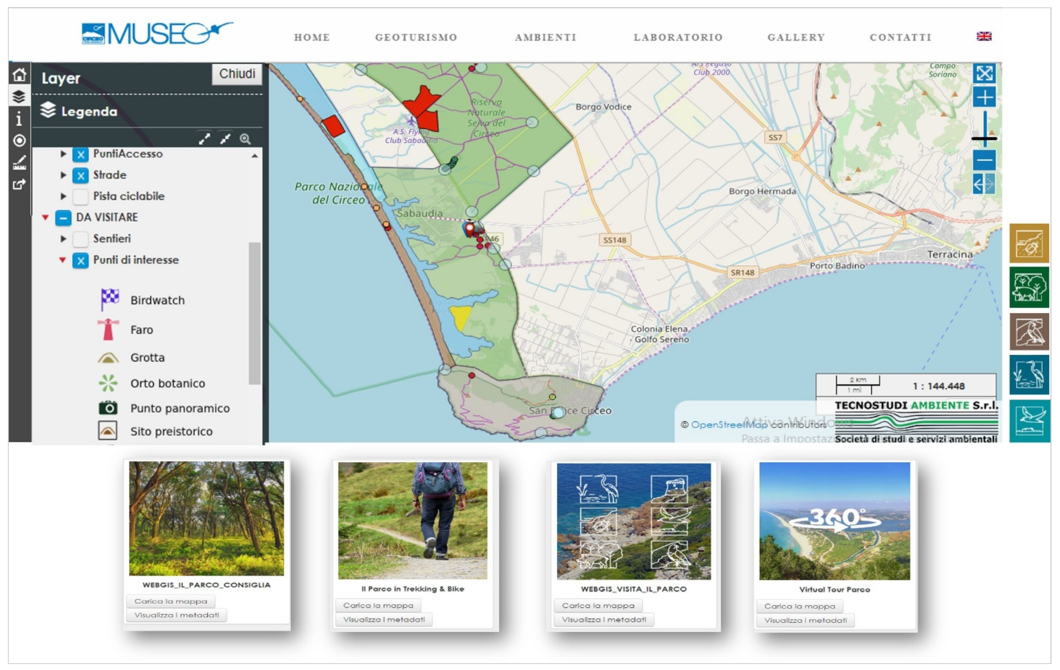
The system has been loaded online, in demo version, in four tourist-oriented OpenSource WebGIS, being dynamic and interoperable, as shown in
Figure 2.
The WebGIS show cycling and trekking routes, cultural tours, and all the geo-tourism offered by the park. Access is possible both from PC and mobile devices.
The WebGIS dedicated to the park, through simple and immediate navigation, enable users to query the data organised in layers (geology, points of interest, land use, roads, trails, bike paths, positioning of sites and archaeological areas, etc.), as well as to take measurements, filter information, run queries, download and save data through a permalink, and check their geolocation when they access the service inside the park. The platform dedicated to the park provides access to the information processed internally by the Park Authority, discloses any technological adaptations of the various sites and becomes a new form of consultation of cultural data to suit customer’s requests.
The dynamic WebGIS can be continuously implemented and combine the proposed paths with other data, such as accommodation facilities, refreshment points, panoramic viewpoints, shops and local handicrafts, bathing establishments, etc., making it possible to organise a visit to the park based on the points of interest arranged along the route on the map. Finally, it can be considered as a powerful didactic tool, as it allows locals to broaden their knowledge of the territory where they live and gives tourists the opportunity to discover the park and its history.
3. New Technologies for the Dissemination of Natural and Cultural Heritage
Identifying the protection and enhancement of heritage as an essential driver of economic production involves not only the generation of new resources but also a policy of conservation of the assets themselves.
Therefore, it is necessary to safeguard every site or monument of cultural and tourist interest and at the same time, to enhance them in many ways. One of the most significant and strategic elements from this point of view is raising the quality standards and enhancing the usability of the sites.
This can be achieved through appropriate operations such as those that affect the understanding of the assets of a territory. The project entailed the development of different innovative products aimed at enhancing the specific and typical characteristics of the park, supporting tourist and cultural promotion and improving its usability.
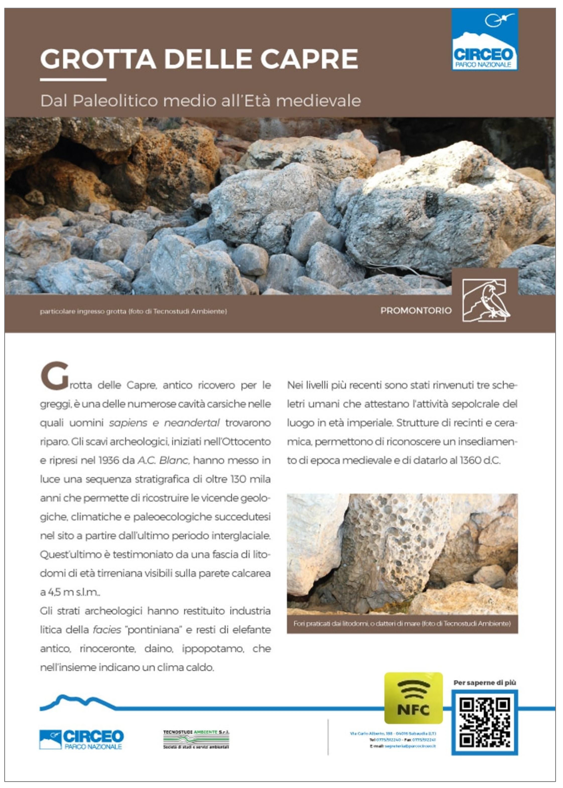
First of all, a digital panel system has been introduced, suitable both for archaeological and natural contexts, as shown in
Figure 3. Information panels have been installed at the main sites of tourist interest in the park, with NFC tags and QR codes that can be scanned with a smartphone to view a reference web section and access further information on the site or on the asset.
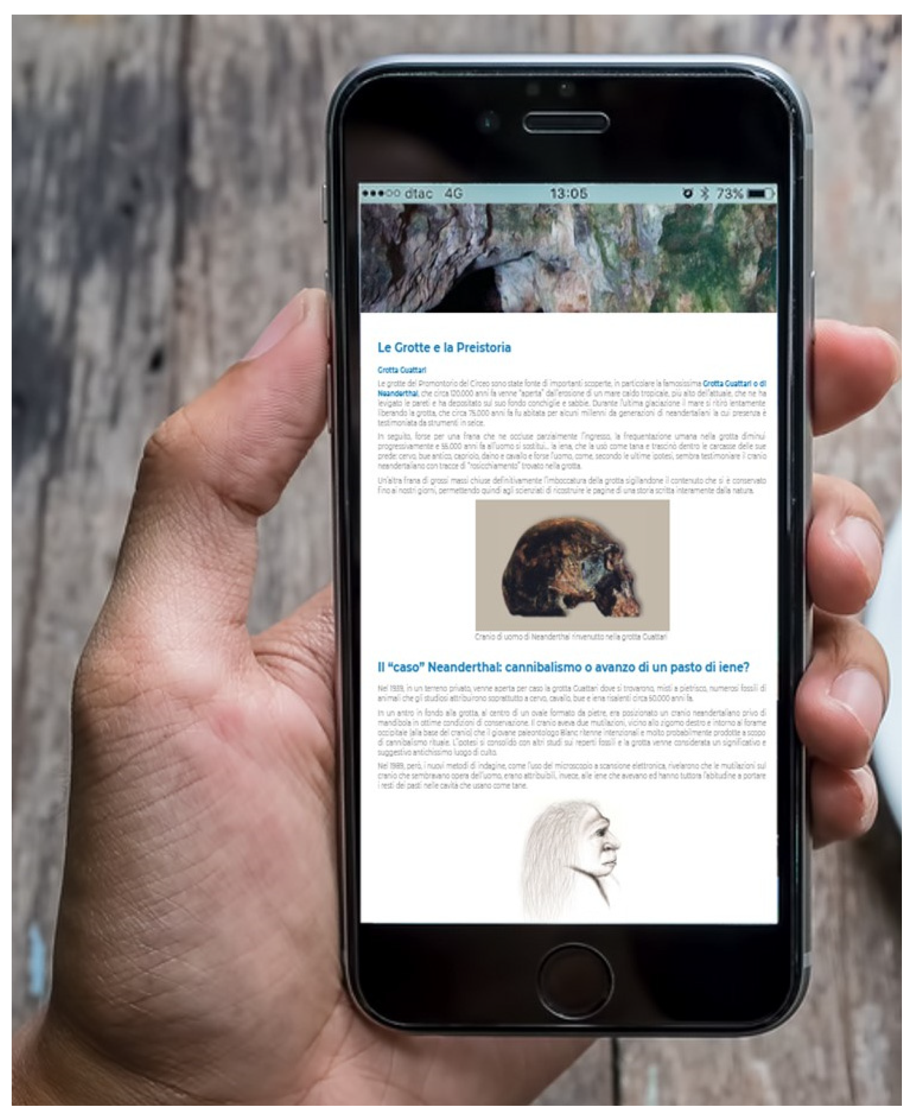
The platform has been integrated into a new portal dedicated to the park museum that hosts the products developed. In addition to WebGIS, navigable models (StreetView and VT360°) of some points of interest and 3D renderings of particular archaeological and palaeontological elements have been uploaded. The three-dimensional models used for the reconstructions, created using 3D photogrammetry techniques, make it possible to try a new form of communication of archaeological data and are presented as smart applications for educational and laboratory experiences.
Finally, the dissemination of a mobile app concerning some themes completes the system, enabling the park to improve its geotourism offering (
Figure 4).
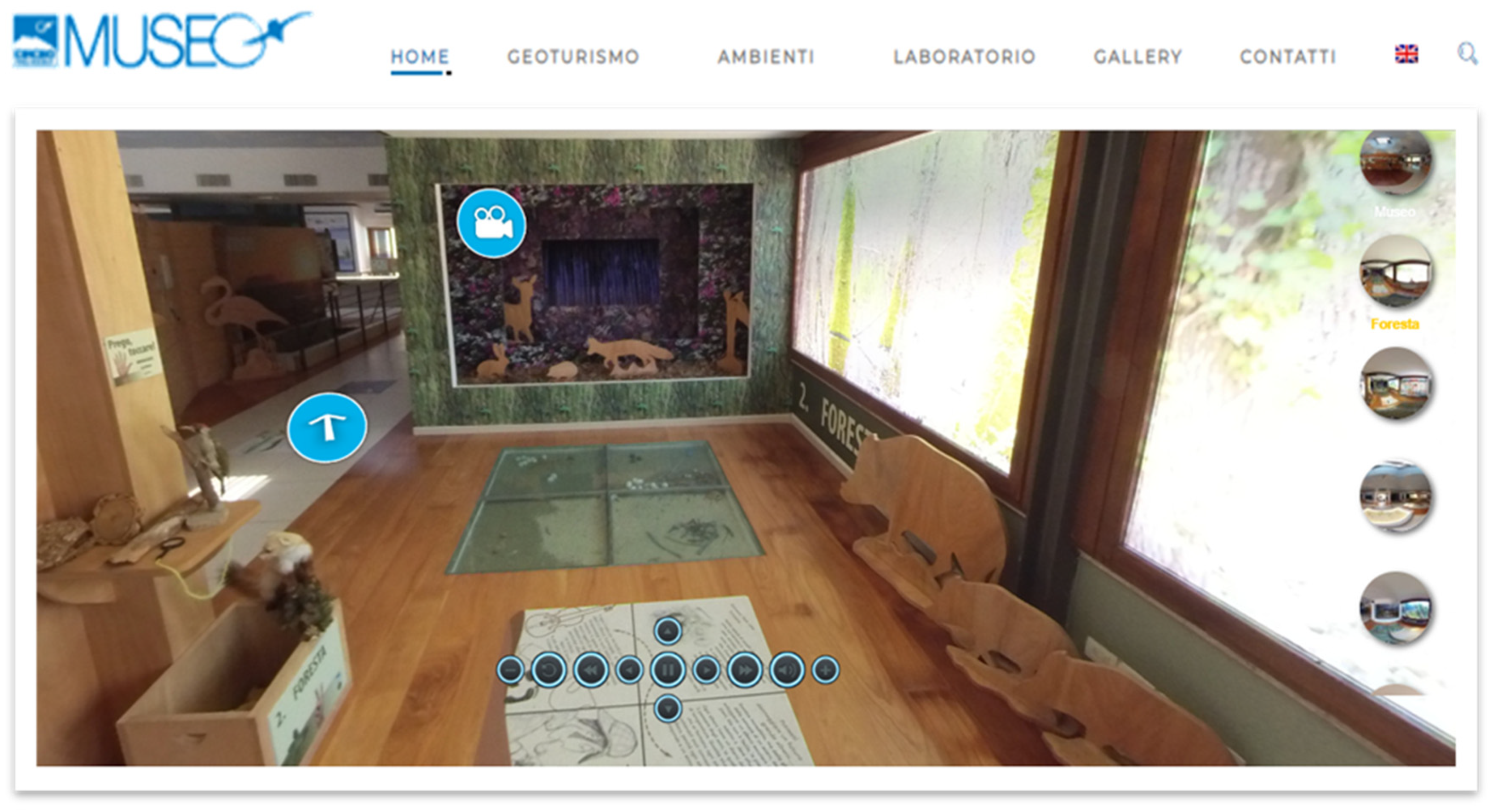
The products created have been integrated into a portal dedicated to the park museum (
Figure 5).
The Park Museum has no collections and does not qualify as a museum in the strict sense of the word, but rather as a venue where visitors are welcomed and guided through the area and in planning their visit. Virtual Tours and navigable Street Views made with 360° photos of some points of interest such as the museum rooms, the Cyclopean walls of the 4th century BC, the pool of the blue shark in the lowland forest have been uploaded to the portal. They give access to in-depth information and multimedia content.
The website also hosts 3D renderings of particular archaeological and palaeontological elements, such as the Cyclopean walls, the bivalves, the skull of a fossilised mouflon, and the interior of some of the Promontory’s caves. The three-dimensional models used for the reconstructions, made with low-cost technologies using 3D photogrammetry, make it possible to move around the models, to take measurements if the models are scaled, to make sections and change colours.
QR Codes and NFC sensors have been placed in the museum, including on specially made 3D prints, to provide direct access to online information.
4. Conclusions and Future Developments
Areas of natural or cultural interest, if well organised, can promote and enhance their environment, improve their ability to attract visitors and create an economic hub the resident population can benefit from. The systems integrated into GIS environment and Geotechnologies have now become part of territory management and are one of the measures that technologically help disseminate knowledge about cultural heritage and protect it.
This work represents the first step of a project aimed at using geotechnologies to help dynamically promote the knowledge of the territory and enhance the cultural and tourist resources of the park, as well as provide a tool for collecting, managing and integrating heterogeneous territorial information, ranging from areas of relevant naturalistic value to anthropic structures of historical interest, from hiking trails to places of greatest tourist interest.
The creation of attractors being able to enhance the territorial resources in the field of educational, hiking and cultural tourism can play a key role in helping overcome the strong seasonality of the current tourist presence connected with the summer period, with positive spill-over effects on the development of the businesses present in the area. The information system can be continuously implemented on the basis of targeted requests and support a predictive approach in landscape management and tourism policies, as well as provide useful information for a flexible and customised offer of tourist itineraries.
Knowing the actual size and status of the heritage, be it plant, anthropic or archaeological assets, facilitates work scheduling, optimises the activities related to data management, allows monitoring and documenting all activities that take place in a given context, both spatially and over time.
The project is developing in two directions. On the one hand, the data management system is being expanded with a desktop platform that contains not only tourist information, but also data related to the technical and administrative management of the park. On the other hand, it is being expanded to include those museums that host findings from the park sites, first and foremost the Prehistoric and Ethnographic Museum L. Pigorini that holds the famous Neanderthal skull of Grotta Guattari and several specimens of the well-document lithic industry found in the caves of the promontory. The aim is to create a multimedia connection between the archaeological sites and the museums that contain the finds removed from their context. Therefore, both at the site and in the museum, visitors can consult descriptive data and are also given the option of easy spatial exploration of the virtual reconstructions of the finds and of the sites.
This opens the door to the inclusion of possible new features for the dissemination of the contents of museum space and calls for a “rethinking” of museums as places where the user, by means of technologies based on a renewed communicative and participatory language on Cultural Heritage, can become the protagonist of the visiting experience.


