Proceeding Paper

Analysis and Validation of the 3D Reconstructive Process through the Extended Matrix Framework of the Temple of the Roman Forum of Nora (Sardinia, CA) †

1
Department of Cultural Heritage, University of Padua, 35139 Padua, Italy
2
National Research Council—Institute of Heritage Science (CNR-ISPC), Area della Ricerca di Roma 1, 00015 Monterotondo, Italy
*
Author to whom correspondence should be addressed.
Presented at the ArcheoFOSS XIII Workshop—Open Software, Hardware, Processes, Data and Formats in Archaeological Research, Padova, Italy, 20–22 February 2019.
Environ. Sci. Proc. 2021, 10(1), 18; https://doi.org/10.3390/environsciproc2021010018
Published: 7 December 2021

Abstract

:
In this work, we will describe the application of the Extended Matrix Framework (EMF) to the 3D reconstruction of the temple on the Roman forum of Nora. EMF represents a specific section of the Extended Matrix (EM) method, developed by the VHLab of the CNR ISPC (Rome), dedicated to the development of software solutions for 3D data management in the field of virtual reconstruction. The combination of EM and EMF allows to: map the reconstructive process, validate the entire workflow (from data ingestion to 3D modelling), manage 3D data, and share outcomes online.

1. Introduction

This article illustrates the tools for the analysis and validation of reconstructive processes through the Extended Matrix [1,2,3] carried out for the use case of the Roman temple of Nora. In recent years, the issue of transparency of reconstructive hypotheses has begun to receive greater attention from the scientific community. The general principles of transparency in the visualisation of the archaeological record already promoted by the London charter and the Seville principles have been followed by various approaches with the attempt to represent the degrees of uncertainty of the reconstructive hypothesis. Despite the importance of defining a formal tool to describe reconstructive processes, there is a general fragmentation of approaches, relegated to different disciplinary needs (architecture, landscape studies, archaeology, etc.), which in turn rely on different technologies (HBIM, GIS, 3DGIS, etc.). This contribution focuses on the use of stratigraphic reading as a universal language that cuts across different disciplines: based on the temporal reading of material and documentary remains, it is possible to organise, interpret, and publish data through EM. In the next section, the formal tool of EM will be briefly presented, while in Section 3, its concrete use in the use case of the Forum of Nora will be illustrated. The progress of the development of the online tool EMviq [4], through which the entire reconstructive data-set can be disseminated online, is presented in Section 4. The article made it possible to validate the EM tool against a real use case and to highlight some aspects of possible improvement for the formal language.

2. The Extended Matrix Method

The Matrix is a formal language and method for creating a reconstructive record. The development of this tool was inspired by Niccolò Stenone’s theory of gaps [5], according to which, thanks to the principles of stratigraphy, it is possible to distinguish the elements that can be reconstructed with certainty from those that have a lower degree of reliability. The task of the EM is to archive and analyse this data and to provide simplified representation tools (through proxy models and coded color scales) aimed at helping the collaborative work of specialists from different disciplines. In this way, it is possible to distinguish the material remains in their primary location (the stratigraphic units, in red), the elements that can be reconstructed with certainty (the virtual structural stratigraphic units, in blue), and the elements that do not provide certainty that they really existed, but which nevertheless have indirect evidence that allows their reconstruction (the virtual non-structural stratigraphic units, in green). In addition to these elements, there are grey areas, such as the fragmentary anastylosis of elements found in a “secondary position” (e.g., a column fragment found collapsed on the ground; a specialization of the virtual non-structural stratigraphic unit, in yellow). The peculiarity of the Extended Matrix is in the creation of a reconstructive record developed within a graph database in which the temporal relationships between the reconstructive elements are expressed. The EM was developed by drawing inspiration from Harris’ classic Matrix, with which it largely retains backward compatibility, but adding information on the provenance of the data: for each virtual stratigraphic unit, the sources used and how they were interpreted are declared and linked together in order to propose the reconstructive hypothesis. Within this research, version 1.2 of the Extended Matrix was used.

3. The Temple of the Roman Forum of Nora

3.1. Research Purpose

The case study presented in this work deals with the application of the Extended Matrix (EM) method for the virtual reconstruction of the temple of the Roman forum of Nora. The archaeological remains of the temple, subject of this work, occupy the northern side of the Roman main public square of Nora (see Figure 1), a monumental complex which was built on the eastern sector of this ancient city situated about 30 km south-west of Cagliari (Sardinia, Italy). The forum of Nora represents the main case study of a doctoral project, in progress at the Department of Cultural Heritage at the University of Padova. The project aims to propose a 3D reconstruction of the forum, by applying the EM method, in order to: offer a virtual reconstruction of the archaeological remains dealing with one of the most extensive monumental area of Nora; make transparent, visible, and comprehensible the whole reconstructive process; and share all outcomes with the public through an online service.

3.2. Archaeological Researches at Nora

Research at the archaeological site of Nora has been carried out since 1990 by different Italian Universities (Pisa, Venezia, Padova, Milano, Viterbo, Genova and Cagliari) in many areas of the ancient city [6]. Focusing on the Roman forum area, where the University of Padova worked from 1997 to 2006, the excavation of this monumental sector of the ancient city allowed to comprehend the complex and long history of the site, testified by its archaeological remains, from the Archaic epoch until Late Antiquity [7]. From an early Archaic settlement, which consisted of simple structures (huts) made of perishable materials, over the centuries, under the influences of different cultures, the site changed its layout until it became a Roman city. Over the years, the municipium of Nora (status acquired probably in the period 50/30 B.C.) was provided with private, public, and religious buildings typical of the Roman culture and also new infrastructures. The Roman forum of the city represents an emblematic example of this urban development process. During Late Antiquity, despite the hard difficulties connected with the barbarian movement trough the sea routes from Africa, Nora was still attended. This aspect has been observed in different areas of the site [8,9].
Figure 1. Reconstructive plan of the Roman forum of Nora. The temple (II.1) was built on the north side. Different colors indicate chronological periods, Period IV (in red) and Period V (in blue) [10] (337, Figure 78).
Environsciproc 10 00018 g001

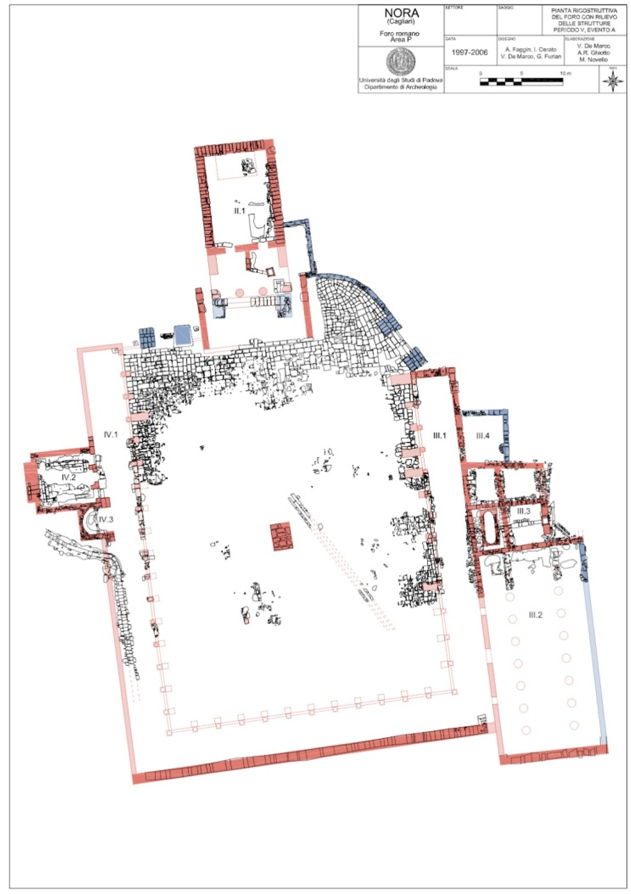
3.3. The Temple of the Forum: Archaeological Context

From a topographical point of view, the temple of the forum was built on the northern side of the Roman square, approximately in the center, in a setback position from the square (see Figure 1). Its particular location, the stratigraphic sequence itself, and all the structural remains discovered throughout the excavation have allowed to advance an initial reconstructive proposal of the building (the one presented in this paper) independently from the whole forum. As already mentioned, the Roman city presents multiple chronological phases; this particular aspect is also confirmed by the stratigraphic sequence of the temple. Indeed, the religious building was erected above a previous place of worship which influenced its architecture (orientation, shape, and structure) [11,12]. For this work, two archaeological phases were analyzed, Period IV (40/20 BC-200/225 AD) and Period V (200/225 AD–400 AD). The first corresponds with the construction of the temple, and the second deals with some architectural changes which were made to its structure. Due to some events, during the centuries, the whole context of the forum became a source of supply for building materials [10]. This particular aspect, archaeologically documented, affected the architectural integrity of the structure. Today, the structural evidence related to the Roman phase of the temple (Period IV and Period V) concerns only a limited group of testimonies (foundations of walls, remains of floors etc.).

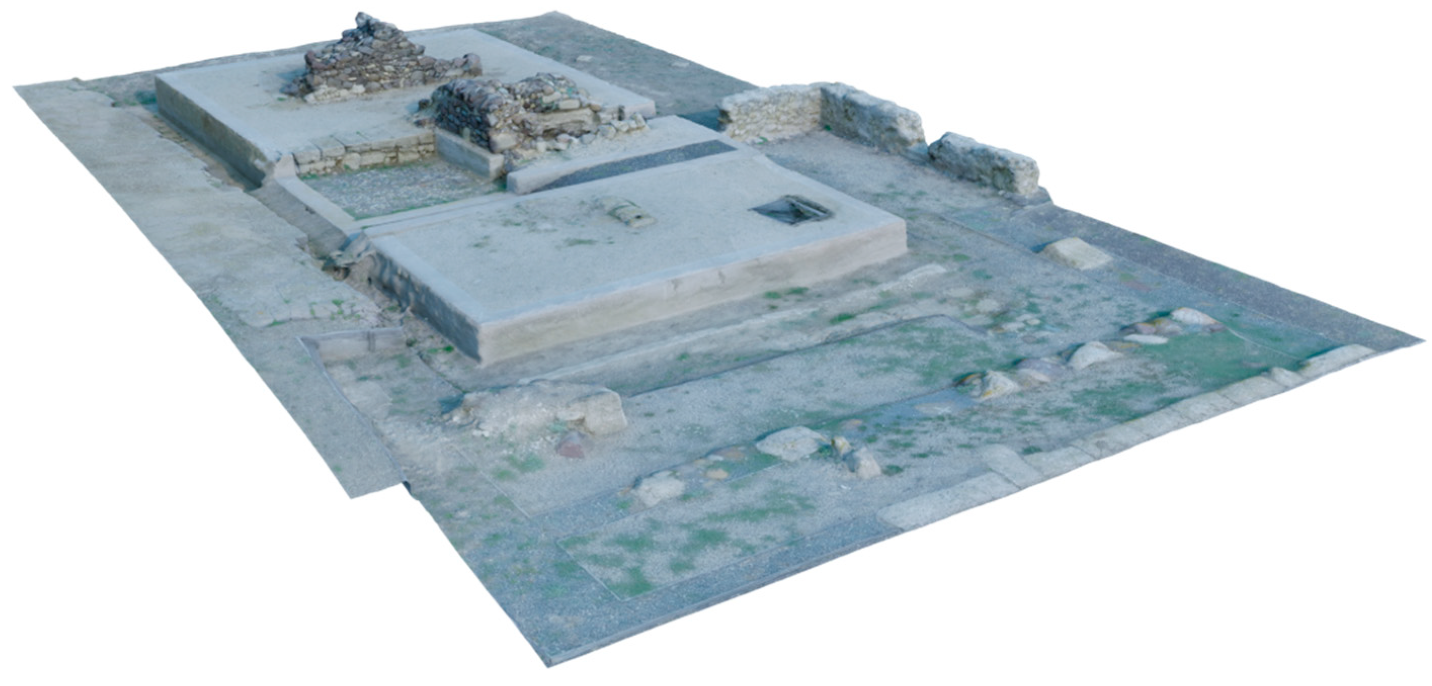
3.4. The Photogrammetric Survey

Before starting the reconstructive process, a photogrammetric survey of the area was executed (see Figure 2). The survey was performed with an action-cam (at this stage of the project, it was not necessary to realise a high-resolution digital replica of the remains). In 2008, the whole area of the forum was enhanced with a low impact intervention which aimed to consolidate the archaeological remains. As a consequence, most of the archaeological trenches inside the forum were covered in order to display to the public, with gravel of different colors, a proposal of the ancient floor level and its function [13]. The photogrammetric survey of the temple (about 600 sqm) was extracted from a more extensive survey (about 3500 sqm) of the whole forum. This sector of the Roman square was acquired, at first, with a path around the remains of the temple and, after, with a trajectory suitable to register also the information of the inner part of the building. All the photogrammetric process was operated within Agisoft Metashape Pro. The whole data-set (4030 images with a 2K resolution, 2704 × 1520) was divided into 8 chunks. The merging of these chunks was fulfilled by using 78 geo-referenced ground control points (GCP) distributed on the whole surface of the forum. Within the 8 chunks, the average total position error was 6.5 mm for Control Points and 7.5 mm for Check Points. From a geometric point of view, the 3D model displayed an average ground texture resolution of 3.16 mm/pixel. The survey of all the context has been useful, not only from a geometric and volumetric point of view, but also from a semantic perspective in the framework of the EM method.

3.5. The “Virtual Terrain” for the Reconstruction

At the beginning of the reconstructive workflow, the photogrammetric model of the temple was optimized for improving the visualization process inside Blender, the 3D software used for modelling the reconstruction. In a second moment, the optimized data were used to carry out a semantic interpretation of the archaeological context, following the principles of the Extended Matrix approach. In a third moment, these data were used as a “virtual terrain” to organize and develop the whole reconstructive proposal. All these stages of the project (the optimization, the semantic analysis of the photogrammetric data, and the 3D modelling) were performed within the same software (Blender) using two add-ons (3D Survey Collection—3DSC—[14] and Extended Matrix Tools—EMTools—[15]) developed from the Virtual Heritage Laboratory (VHLab) of the CNR IPSC of Rome. 3DSC was employed to import, export, edit, manage, and segment the photogrammetric data. EMTools was used to provide interaction with the EM graph without changing the workspace and to export 3D models for online visualization through the EMViq tool [4] (Extended Matrix visual inspector querier—see Section 4).

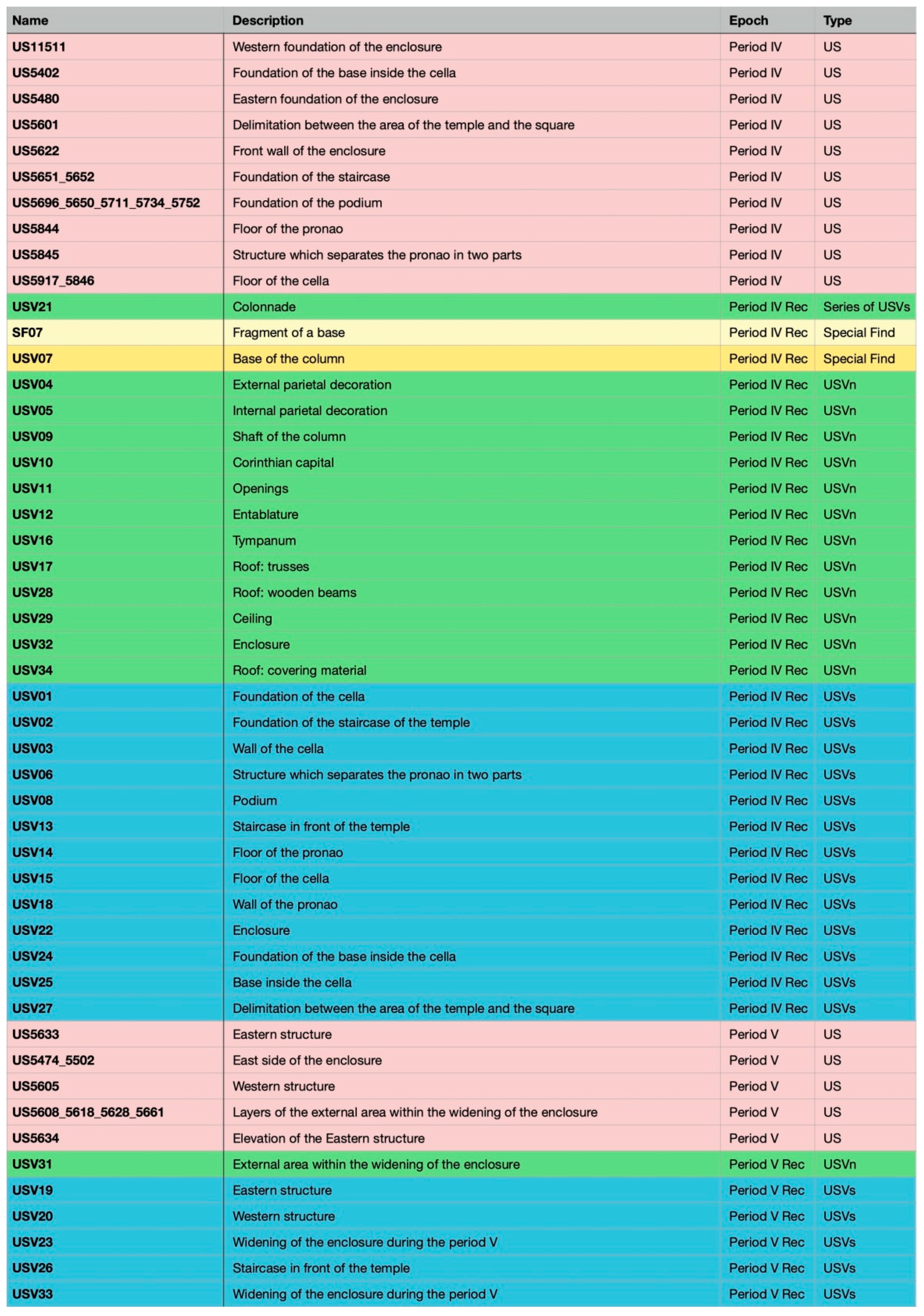
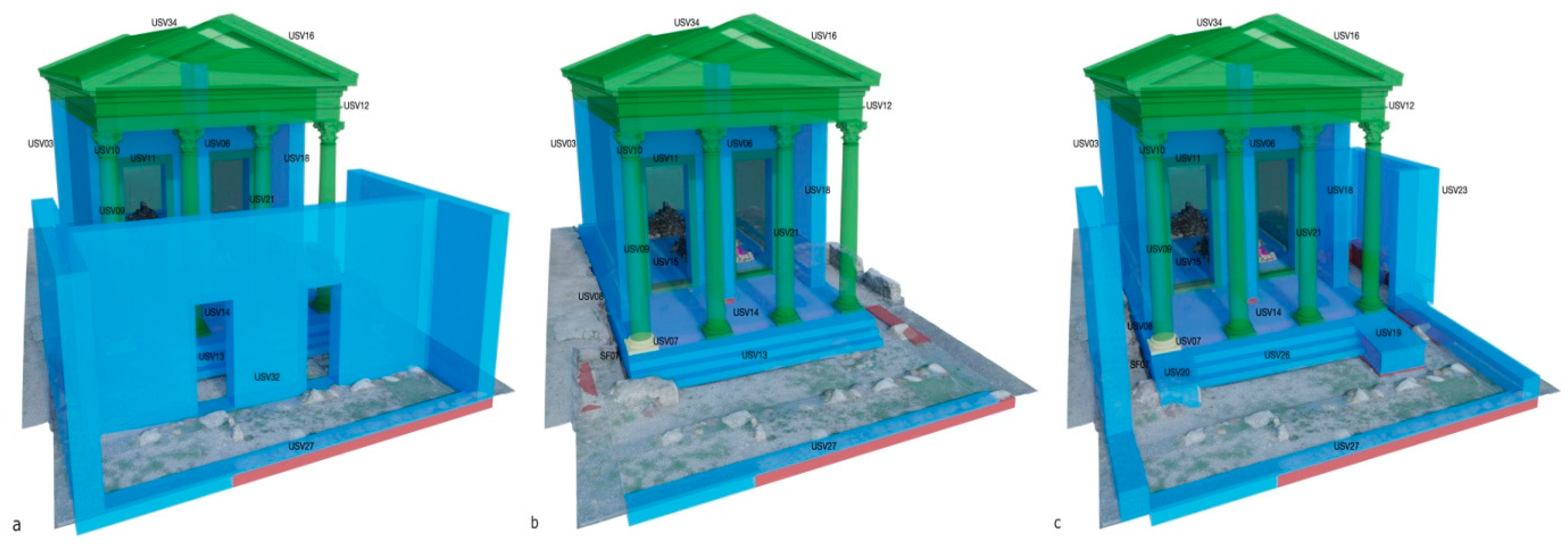
3.6. 3D Reconstruction Workflow Following the Extended Matrix Approach

When the “virtual terrain” setting was completed, a data collection step was required to achieve the reconstructive intent of the project. First of all, all the archeological data referred to the temple (information about the stratigraphic units, Matrix of Harris, drawings, images etc.) were identified within the monograph dedicated to the ten-year archaeological mission of the forum (1997–2006) made by the University of Padova [7]. Then, all the information was gradually transferred inside the EM of the temple. For this step of the workflow, the graph editor yEd was employed to realize the EM. In a further moment, the semantic analysis of the photogrammetric mesh was made by modelling on the surface of the “virtual terrain” all the proxy geometries referred to the stratigraphic units (SU). This phase of the workflow facilitated the viewing of the archaeological remains of the temple using meshes with a red color. As previously explained, the lack of structures was due to the fact that, throughout Late Antiquity, the forum became a source of supply for building material useful for the construction of other buildings. By following the Extended Matrix data, the second stage of the reconstructive process was pursued. USV/s and USV/n proxy models were drawn, respectively with a blue and a green color. As already mentioned, proxy models represent the connection between Blender and yEd. These softwares communicate by using EMtools add-on (for local data representation within Blender) or EMviq (for online data representation). For this reason, proxies do not require high resolution quality, since they are only a way to visually represent the reconstructive record and to highlight representation models (those with texture information). The use of USV/s (blue color) was limited to circumstances where the existing remains (i.e., foundations and elevations of walls) were suitable to orient the reconstructive process. On the contrary, USV/n (green color) was used when the reconstructive proposal was related to the use of external sources (i.e., manuals of Roman architecture, scientific literature for specific comparisons etc.). The Extended Matrix of the temple (see Figure 3) was planned by following the Matrix of Harris of the temple itself. In yEd, the graph was horizontally divided in two chronological periods (Period IV and Period V) and two reconstructive chronological periods (Period IV rec and Period V rec). The granularity of the archaeological record, as in the Matrix of Harris, was organized in activities where the different EM nodes were then grouped together (“activities” for the chronological periods and “virtual activities” for the reconstructive chronological periods).

3.6.1. 3D Reconstruction of the Temple, Period IV (40/20 BC–200/225 AD)

As already mentioned, the reconstruction was focused only on two chronological phases, Period IV and Period V. During Period IV, both the temple and the whole monumental complex of the forum were realized. The excavation evidenced that, from Period IV to Period V, the whole scheme of the building did not drastically change. Throughout Period IV, an enclosure (USV32), probably characterized with two entrances, separated the temple from the whole square (see Figure 4a). Once inside the area of the temple (see Figure 4b), the access to the building was possible by three steps (USV13) which led, first, to the pronao (enriched with four columns, USV07,09,10,21) and then to the inner part of the building, the so-called cella (USV03). Existing evidence, reported as US, mainly referred to real structural elements (such as foundations and elevations of walls, portions of floors etc.) that were virtually completed with USV/s (see Figure 5). This is the case of the podium of the temple (USV08) which was completed in elevation from the foundations level up to the original floor level, the perimetral walls of the cella (USV03), and the staircase in front of the temple (USV13). In order to establish the approximate height of the perimetral walls (USV03), it was necessary to estimate in advance the height of the column. This operation was executed starting from a so-called Special Find (SF, yellow color). Indeed, two fragments of bases were found during the excavation of the well on the pronao and, in a second moment, one of them (SF07) was connected with the context of the temple and used for the reconstruction. The order and the proportion of the colonnade were assumed by literary sources. As a consequence, for the reconstructive proposal of the colonnade, a USV/n (green color) was employed. In this specific case, to describe the external colonnade of the temple, the seriation node was used. This node underlines the repetition of elements, as in the case of the colonnade of the pronao (USV21). Other structures of the temple, referred to as the upper part of the building, were also classified as USV/n (i.e., entablature, roof etc.). During the excavation of the temple, fragments referred to the first Pompeian style decoration were found. These fragments have been proposed as a possible option for the parietal decoration of the temple, but no further evidence has been found for supporting this hypothesis. In general, for the temple, a new reconstructive proposal for the internal and external materials of the coating is still in progress; as a consequence, this part of the reconstruction process will not be considered in this work. For this chronological period, it has been possible to reconstruct a sacred area, separated from the forum by means of an enclosure, where a temple was built inside. This ancient building has been virtually rebuilt with a tetrastyle temple characterized by a simple staircase on the facade. The staircase would have led to a pronao through which it would have been possible to enter within the so-called cella by means of two separated entrances.

3.6.2. 3D Reconstruction of the Temple, Period V (200/225 AD–400 AD)
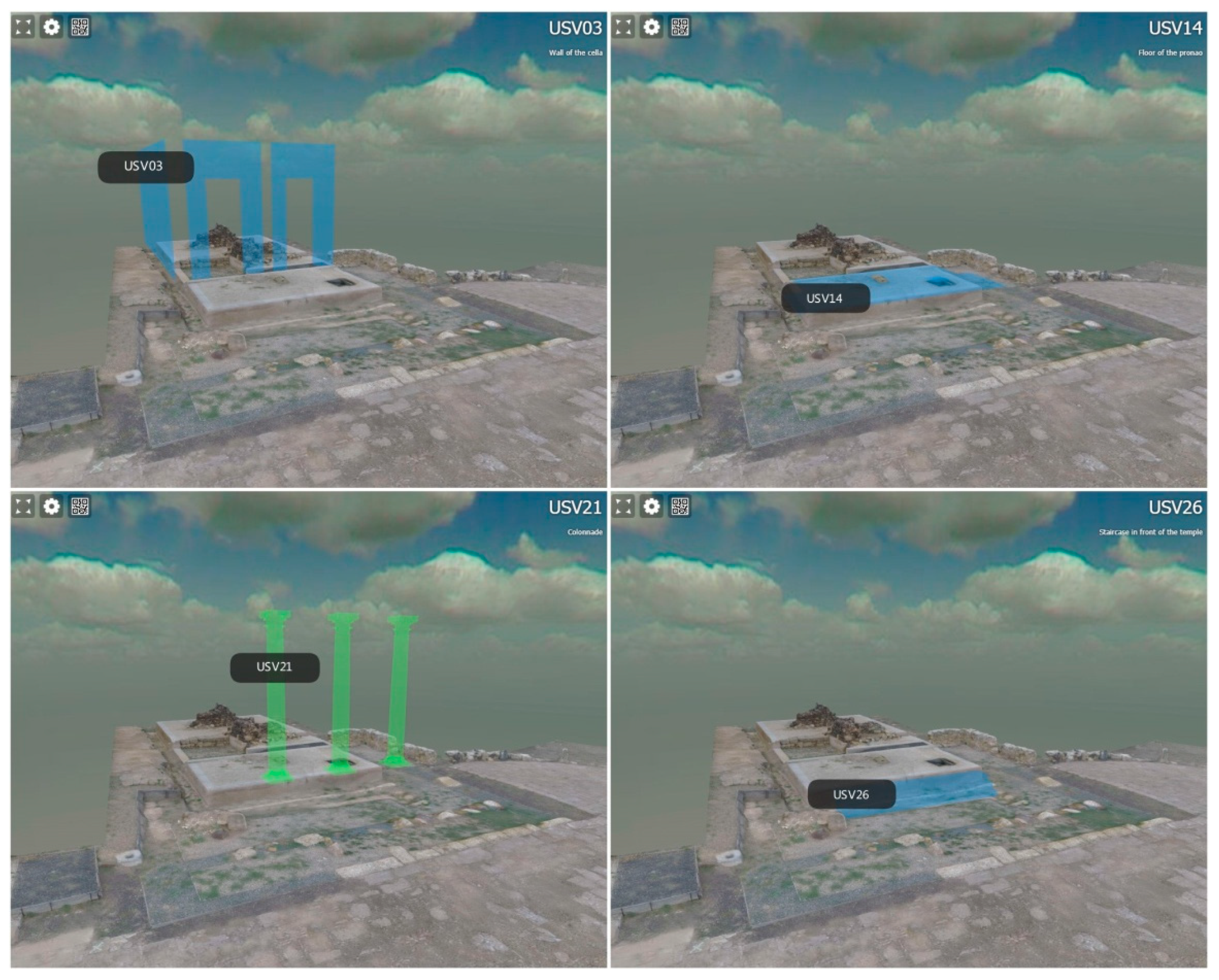
The excavation data from Period IV to Period V highlighted only a few changes focused on the front of the building (see Figure 4c). Two structures were added on the east (USV19) and west (USV20) side of the staircase which was reduced on its horizontal extension (USV26). In this case, extant evidence about these new changes were discovered. Therefore, these structures were highlighted both as SU (extant remains) and USV/s (reconstruction from extant remains). The enclosure was modified; the wall which divided the temple from the square seems to have been removed. As a consequence, its general structure changed. The enclosure was preserved only along the western and eastern side of the temple with an enlargement on the eastern side (USV23). No information was found about other architectural changes. These structural remains were considered as USV/s. Their reconstructive elevation was approximately estimated from a comparison with the other structures of the forum (portico and monumental entrances). Even though they inherited the height property from other virtual stratigraphic units, their existence was justified by the remains; as a consequence, the reconstruction was identified as USV/s. Due to the restricted number of changes dated to this chronological period, the Extended Matrix referred to this specific phase of the temple presented a limited number of virtual activities.

4. EMviq

“EMviq” (Extended Matrix Visual Inspector and Querier) is a complete, interactive 4D visualisation and run-time interrogation tool for Extended Matrices (EM). The tool [4] focuses on automatic extraction from GraphML files (EMs) targeting 3D visualisation, ease-of-use, and performance in order to establish a fast and robust pipeline within a multi-disciplinary team. To inspect and query at run-time a single Extended Matrix described by GraphML, the tool automatically translates EM into appropriate run-time data structures [2], more specifically:
  • Timeline: a finite number of time-periods (each with a specific ID);
  • Proxy-Graph: a graph of 3D proxies targeting real-time queries and interrogation. Production of such graph may involve procedural sub-graphs (e.g., “Seriation Node”) by instancing the referenced 3D proxy element into multiple locations, depending on transformation rules;
  • Source-Graphs: an internal run-time representation of EM sources relationships (paradata).
The first version of EMviq (2016) was a desktop-based application developed on top of OpenSceneGraph framework: the tool was also exploited to research immersive interfaces for VR queries in 4D virtual environments [16]. A new version of EMviq was developed within the SSHOC project: the new tool is completely web-based (see Figure 6), developed on top of ATON framework [17], thus inheriting all the features offered by the framework. More specifically, it offers a cross-device presentation (mobile, desktop and immersive VR devices), fast queries in 4D spaces (high-performance for proxy inspection at run-time), and compliance with modern web standards. The online tool also offers “smart” nsearch capabilities, that allows to search for specific proxies (e.g., “USV100”) or filter by specific patterns (e.g., “USV”, highlighting all USV nodes), as well as searching for specific keywords in proxy description field (e.g., “walls”). Furthermore, it can be integrated with cloud solutions (like ownCloud, nextCloud, etc.) to enable distributed workflow among remote professionals operating on extended matrices.

5. Discussion and Conclusions

The Extended Matrix approach, with all its components (Extended Matrix and Extended Matrix Framework), allows to highlight and attribute the proper weight to all the phases in which the whole reconstructive process was divided. Indeed, the EM approach allows to map the reconstructive process, organise all the information acquired, establish a direct connection between the 3D environment and the EM graph (with EMtools), manage the geometries with different tools (with 3DSC), and easily share 3D models and their information (with EMviq). The application of the EM approach to the temple of Nora allowed to understand the archaeological remains and to offer all the instruments to elaborate and represent a complete reconstruction process; this approach is able to share all the semantic information through the chronology. At the beginning, data were collected and inserted into the EMgraph. Then, the 3D model of the temple was realised inside Blender and, at the same time, a connection with the EMgraph was established in order to validate all reconstructive processes inside the same 3D environment. In the end, the main goal is to publish online the reconstructive proposal of the temple through the EMviq tool (still under development). This new approach allows not only to attribute the same level of importance to all the individual steps which are hidden behind a virtual reconstruction process, but also to establish new means of interaction with virtual reconstructions observed from different points of view (professional and non-professional).

Author Contributions

Software, B.F., E.D.; writing: Section 1 and Section 2, E.D.; Section 3.1, S.B.; Section 3.2 and Section 3.3, S.B., J.B.; Section 3.4 and Section 3.5, S.B., G.S.; Section 3.6, S.B.; Section 4, B.F.; Section 5, all. All authors have read and agreed to the published version of the manuscript.

Funding

The research has been partially developed under the SSHOC project: “Social Sciences and Humanities Open Cloud (SSHOC) has received funding from the EU Horizon 2020 Research and Innovation Programme 2014-2020); H2020-INFRAEOSC-04-2018, under grant agreement No. 823782.”

Conflicts of Interest

The authors declare no conflict of interest. The funders had no role in the design of the study; in the collection, analyses, or interpretation of data; in the writing of the manuscript, or in the decision to publish the results.

Abbreviations

The following abbreviations are used in this manuscript:
EMExtended Matrix
EMFExtended Matrix Framework
EMviqExtended Matrix Visual Inspector and Querier
EMtoolsExtended Matrix tools for Blender 3D (python add-on)
3DSC3D Survey Collection for Blender 3D (python add-on)

References

  1. Demetrescu, E. Archaeological stratigraphy as a formal language for virtual reconstruction. Theory and practice. J. Archaeol. Sci. 2015, 57, 42–55. [Google Scholar] [CrossRef]
  2. Demetrescu, E.; Fanini, B. A white-box framework to oversee archaeological virtual reconstructions in space and time: Methods and tools. J. Archaeol. Sci. Rep. 2017, 14, 500–514. [Google Scholar] [CrossRef]
  3. Demetrescu, E. Virtual Reconstruction as a Scientific Tool: The Extended Matrix and Source-Based Modelling Approach. In Digital Research and Education in Architectural Heritage; Münster, S., Friedrichs, K., Niebling, F., Seidel-Grzesińska, A., Eds.; Springer: Cham, Switzerland, 2018; pp. 102–116. [Google Scholar] [CrossRef]
  4. Fanini, B. EMviq Tool. Available online: https://github.com/phoenixbf/emviq (accessed on 29 November 2021).
  5. Hansen, J. Il giudizio di Stenone sulla metodologia cartesiana. Atti del seminario organizzato da Universitetsbiblioteket i Tromsø e l’Accademia di Danimarca (Roma 23 ottobre 2000). 2002; 49–58. [Google Scholar]
  6. Bonetto, J.; Falezza, G. Vent’anni di scavi a Nora. Ricerca, formazione e politica culturale: 1990–2009; Quasar Edizioni: Roma, Italy, 2011; ISBN 978-88-902721-7-2. [Google Scholar]
  7. Bonetto, J.; Ghiotto, A.R.; Novello, M. Nora. Il Foro Romano. Storia di Un’area Urbana Dall’età Fenicia alla Tarda Antichità; Italgraf: Noventa, Italy, 2009; ISBN 978-88-902721-6-5. [Google Scholar]
  8. Bonetto, J.; Ghiotto, A.R. L’Università di Padova a Nora: Dai Fenici ai Bizantini. Tra studio, formazione e valorizzazione. LANX. Riv. della Sc. di Spec. in Beni Archeol. Univ. degli Studi di Milano 2013, 14, 123–156. [Google Scholar] [CrossRef]
  9. Bonetto, J.; Ghiotto, A.R. Nora nei Secoli dell’Altomedioevo; Martorelli, R., Ed.; Academia: Cagliari, Italy, 2013; pp. 271–290. [Google Scholar]
  10. Ghiotto, A. Il complesso monumentale del foro. In Nora. Il Foro Romano. Storia di Un’area Urbana Dall’età Fenicia alla Tarda Antichità; Bonetto, J., Ghiotto, A.R., Novello, M., Eds.; Quasar Edizioni: Roma, Italy, 2009; Volume 1, pp. 247–373. [Google Scholar]
  11. Novello, M. Il tempio del foro. In Nora. Il Foro Romano. Storia di Un’area Urbana Dall’età Fenicia alla Tarda Antichità; Bonetto, J., Ghiotto, A.R., Novello, M., Eds.; Quasar Edizioni: Roma, Italy, 2009; Volume 1, pp. 377–453. [Google Scholar]
  12. Bonetto, J. L’insediamento di età fenicia, punica e romana repubblicana nell’area del foro. In Nora. Il Foro Romano. Storia di Un’area Urbana Dall’età Fenicia alla Tarda Antichità; Bonetto, J., Ghiotto, A.R., Novello, M., Eds.; Quasar Edizioni: Roma, Italy, 2009; Volume 1, pp. 41–243. [Google Scholar]
  13. Bonetto, J.; De Marco, V.; Modena, C.; Valluzzi, M. Dallo scavo alla fruizione: Il consolidamento strutturale e la valorizzazione dell’area del foro. In Nora. Il Foro Romano. Storia di Un’area Urbana Dall’età Fenicia alla Tarda Antichità; Bonetto, J., Ghiotto, A.R., Novello, M., Eds.; Quasar Edizioni: Roma, Italy, 2009; Volume 1, pp. 455–470. [Google Scholar]
  14. Demetrescu, E. zalmoxes-laran/3D-survey-collection: V1.4.73. 2021. [Google Scholar] [CrossRef]
  15. Demetrescu, E. zalmoxes-laran/EM-blender-tools: V.1.1.75. 2021. [Google Scholar] [CrossRef]
  16. Fanini, B.; Demetrescu, E. Carving Time and Space: A Mutual Stimulation of IT and Archaeology to Craft Multidimensional VR Data-Inspection. In Proceedings of the 1st International and Interdisciplinary Conference on Digital Environments for Education, Arts and Heritage, Earth 2018; Springer: Cham, Switzerland, 2018; pp. 553–565. [Google Scholar]
  17. Fanini, B. ATON Framework. Available online: https://github.com/phoenixbf/aton (accessed on 29 November 2021).
Figure 2. Photogrammetric model of the temple.
Environsciproc 10 00018 g002
Figure 3. Extended Matrix of the temple.
Environsciproc 10 00018 g003
Figure 4. Reconstructive proposal of the temple above the photogrammetric model. Period IV, (a) external and (b) internal view; Period V, (c) general view. The uncertainty is indicated with different colors following the EM approach. Red: Extant structures. Blue: Structural virtual reconstruction. Green: Non-structural virtual reconstruction. Light yellow: Fragmental virtual anastylosis. Yellow: Fragmental virtual reconstruction.
Environsciproc 10 00018 g004
Figure 5. Proxies’ table. The uncertainty is indicated with different colors following the EM approach. Red: Extant structures. Blue: Structural virtual reconstruction. Green: Non-structural virtual reconstruction. Light yellow: Fragmental virtual anastylosis. Yellow: Fragmental virtual reconstruction.
Environsciproc 10 00018 g005
Figure 6. EMviq online tool: Runtime inspection of a few proxies of the temple dynamically extracted from the Extended Matrix (GraphML).
Environsciproc 10 00018 g006
Publisher’s Note: MDPI stays neutral with regard to jurisdictional claims in published maps and institutional affiliations.

