Proceeding Paper

Real-Time 3D and Archaeology: A Status Report †

Arc-Team srl, 38023 Cles, Italy
*
Authors to whom correspondence should be addressed.
Presented at the ArcheoFOSS XIII Workshop—Open Software, Hardware, Processes, Data and Formats in Archaeological Research, Padova, Italy, 20–22 February 2019.
Environ. Sci. Proc. 2021, 10(1), 16; https://doi.org/10.3390/environsciproc2021010016
Published: 11 November 2021

Abstract

:
This article summarizes the experience of Arc-Team in working with real-time 3D open software and hardware. This overview describes the research, experiments and professional use of this technology in the field of archaeology. The first part of the article focuses on the FLOSS RGBDemo, describing the software, some preliminary tests and some examples of its professional use in order to underline its limitations and potentialities. The second part of the paper faces the more complex topic of SLAM, considering its connection with archaeorobotics, its versatility and its application for professional purposes, again, analysing advantages and disadvantages.

1. Introduction

This article attempts to summarize the experience of Arc-Team, a commercial archaeological company, in using real-time 3D technologies for professional purposes. The topic was analysed considering the years between 2012, when some preliminary tests were performed with the software RGBDemo, and 2016, when the company defined a new protocol based on SLAM technologies. This acronym for simultaneous localization and mapping refers to several robotics methodologies used to map “an unknown environment while simultaneously keeping track of an agent’s location within it” [1].
The entire research about real-time 3D technologies and archaeology has been based on the free/libre and open-source software (FLOSS) embedded in the GNU/Linux distribution ArcheOS [2]. In the development of some specific archaeorobotic devices [3], open hardware was also used or designed in order to optimize the final result and align it to the acceptable standards of the archaeological tolerance [4].
All the methodologies taken into consideration is described underlining the limitations and benefits, considering the feedback obtained from the fieldwork. Indeed, both of the proposed technologies have been carefully tested within professional projects related to archaeology and, more precisely, to 3D recording of landscapes (survey), structures (excavation) and findings (documentation).

2. RGBDemo

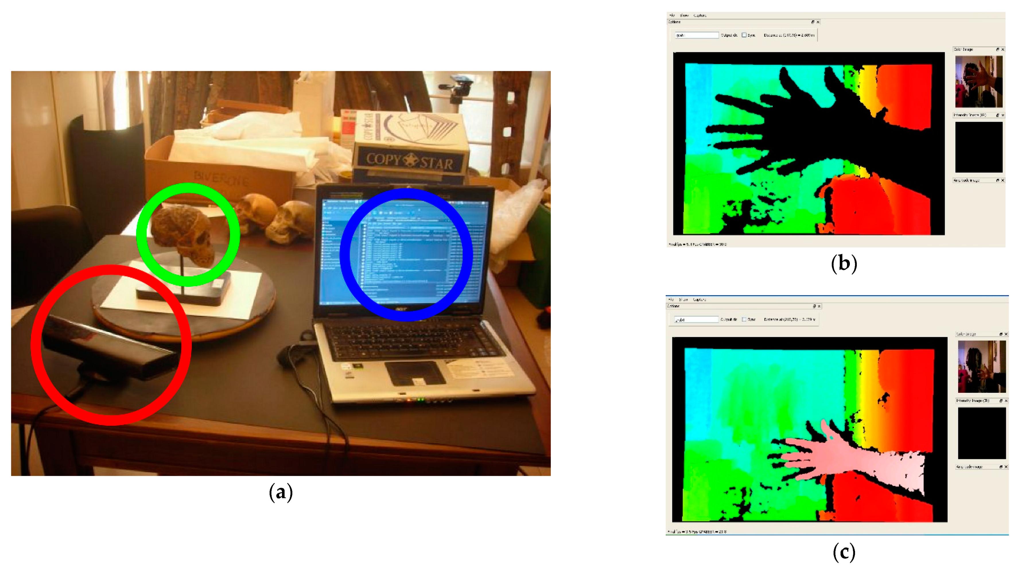
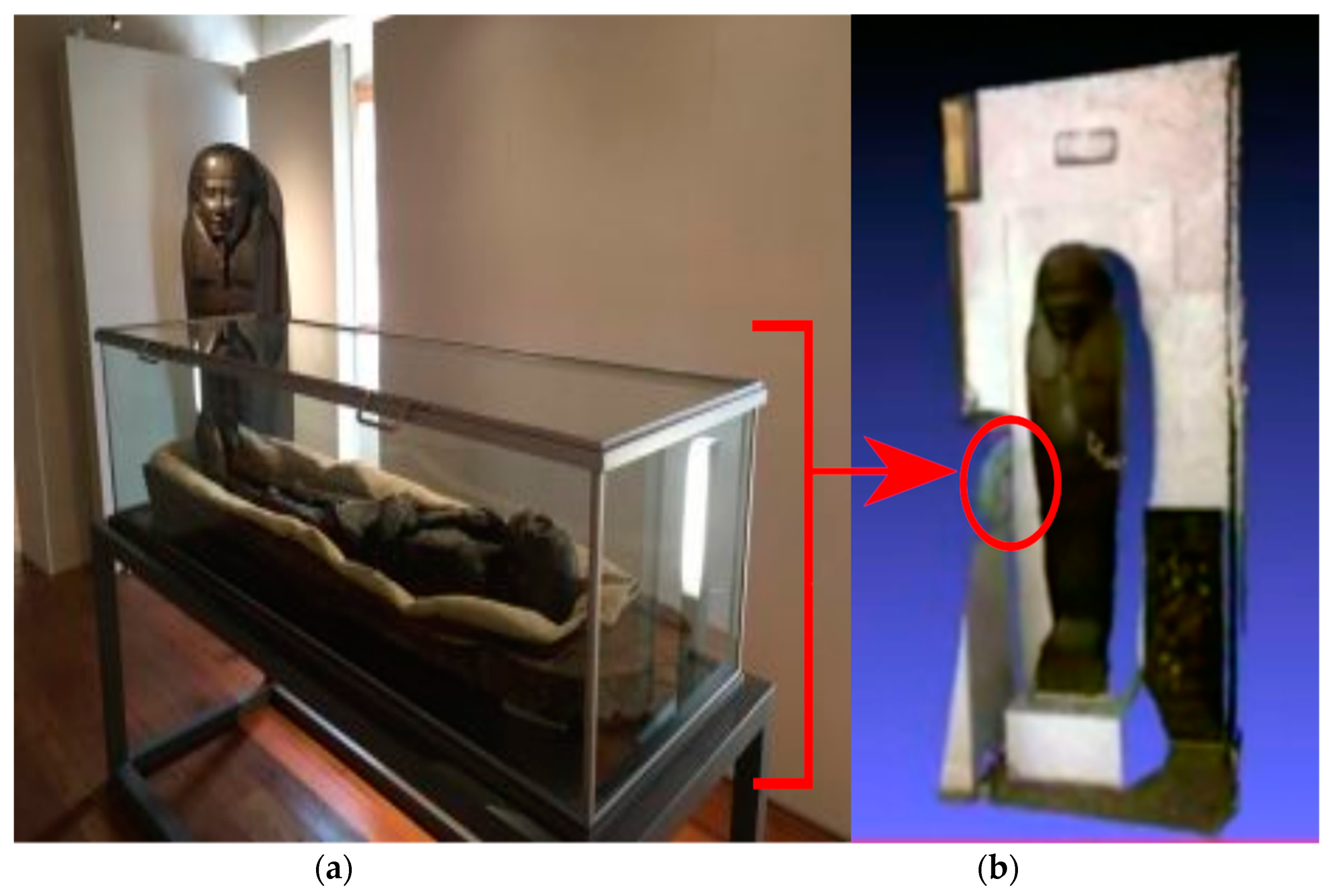
2.1. First Test and Technical Validation

As previously mentioned, Arc-Team’s research on real-time 3D in archaeology started around 2012, with some experiments performed with the FLOSS RGBDemo, developed by Nicolas Burrus and released under the GNU Lesser General Public License (LGPL). The preliminary test (Figure 1) performed with this software [5], which is no longer maintained, provided positive results, which is why it was used for a lesson within the course of Free and Open-Source Software for Archaeology, which was held by two Arc-Team members at Lund University (Sweden).
In short, RGBDemo provides a toolkit to work with the hardware Kinect, the motion sensing input device produced by Microsoft since 2010. The core of this instrument is composed by two RGB (red, green, blue) cameras, combined with some infrared projectors and detectors, able to create depth maps through either structured light or time of flight (ToF) calculations. For this reason, Kinect can be used aside its original purpose (gaming) to register the surrounding environment in 3D in real time.
After the positive results achieved with the first test, a technical evaluation was needed in order to check the parameters of accuracy and precision of this technology for archaeological purposes. This operation was performed during the conference “LOW-COST 3D-Sensori, algoritmi e applicazioni” held in Trento (Italy) in March 2012 [6]. The technical validation showed how, in some cases, the combined use of RGBDemo and Kinect could satisfy the archaeological tolerance [4] even without reaching the high accuracy and precision levels of alternative methodologies, such as SfM–MVS (structure from motion and multiple-view stereovision) [7].

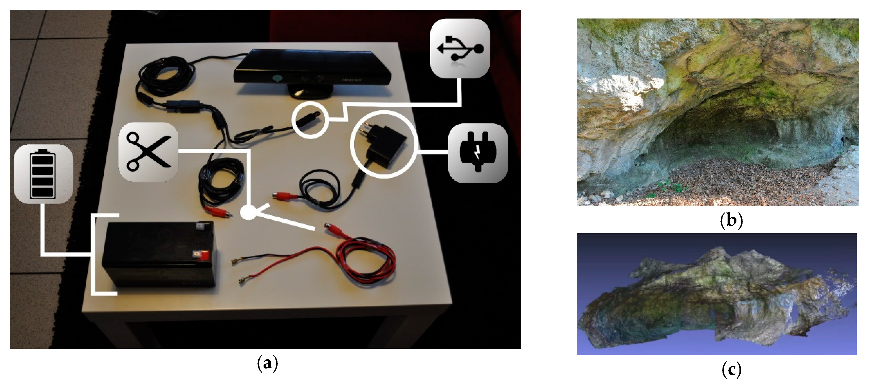
2.2. Limitations, Potentialities and Professional Use

The main advantage of a 3D documentation strategy based on RGBDemo and Kinect is the real-time feedback, without the need to wait for postprocessing operations. Nevertheless, this methodology still presents several limitations and, nowadays, can be considered obsolete. These limitations became evident as soon as after some tests [8] performed during the Taung Project [9] (Figure 2a). First of all, if the Kinect’s sensors are too close to the target (short-range documentation), they do not work properly, and the target itself is not “seen” by the hardware (Figure 2b). Moreover, when working with small objects, even maintaining an adequate distance from the target can lead to low-resolution acquisitions (Figure 2c).
Another problem highlighted by the test performed during the Taung Project is related to the Kinect sensors: far-infrared rays do not pass through transparent surfaces such as glass or acrylic plates. Indeed, during the attempt to scan an Egyptian sarcophagus (Figure 3) [8], RGBDemo recorded a 3D scene with the related mummy and its showcase: the transparent plates (glass) were registered as normal opaque surfaces. This aspect is particularly limiting in those archaeological projects where it is necessary to scan the findings preserved in display cases, without the possibility of moving them. However, the main issues of this system are related to the outdoor environment and, in archaeology, to excavations and surveys. Indeed, despite the autonomy of the software component (which can be installed on a regular laptop with a power supply), a Kinect needs a direct link to the electrical mains. This problem can be solved with a minor hardware hack [10], cutting the main cable before the electric plug, adding regular connectors on both sides (to keep the possibility of using the device indoors) and preparing a new cable with FASTON connectors to be used with a rechargeable lead battery (12 V, 7.2 A⋅h).
Once the hardware has been modified into a portable device (Figure 4a), it can be used to record 3D documentation in the field, considering one last limitation: it cannot work in direct sunlight conditions (Figure 4b,c).
As for the other issues (close-range targets and transparent surfaces), these problems also derive from the infrared Kinect sensors [12]. Indeed, with this technology, “direct Sun illumination leads to saturation in the depth acquisition” [13]. Despite this, a prototype composed of a rugged laptop with RGBDemo installed and a hacked Kinect was successfully used by Arc-Team during professional excavations [14] in both indoor (Figure 5) and outdoor environments (with controlled light conditions or during cloudy days).
Aside the evident limitations mainly derived from Kinect’s infrared sensors, Arc-Team’s prototype also demonstrated some unexpected potentialities, especially in the field endoscopic prospecting of burial structures [16].
As an example, during the professional excavation of the ancient S. Giorgio church of Dorsino (TN, Italy), this device was used to estimate the internal volume of the underground environment, simply registering a real-time 3D scene through a small hole in the northern part of the structure, without the need to use additional lights (Figure 6a). This potentiality is related to infrared sensors, which can also work in low light conditions (Figure 6b,c). Despite the fact that an internal view of burial structures can also be achieved using regular video inspection techniques [17], the advantages of an infrared-based technology consist not only in the possibility of avoiding strong illumination from the outside, which could alter the delicate equilibrium of an ancient closed environment, but also in the real-time 3D scene-capturing system, which does not need further processing to display metric values. Indeed, RGBDemo, in combination with calibrated hardware such as Kinect, can record a 3D scene in real scale without the need in external information such as ground control points (GCP). Nevertheless, these minor benefits in the prospecting field cannot balance the limitations of a technology which nowadays can be considered obsolete. For this reason, around 2016, Arc-Team renovated its interest in real-time 3D sensing with Kinect due to the results achieved in the internal research program on archaeorobotics [3]. These new experiments led to the use of SLAM algorithms within the open-source robotic suit ROS (Robot Operating System), which is described in the next section.

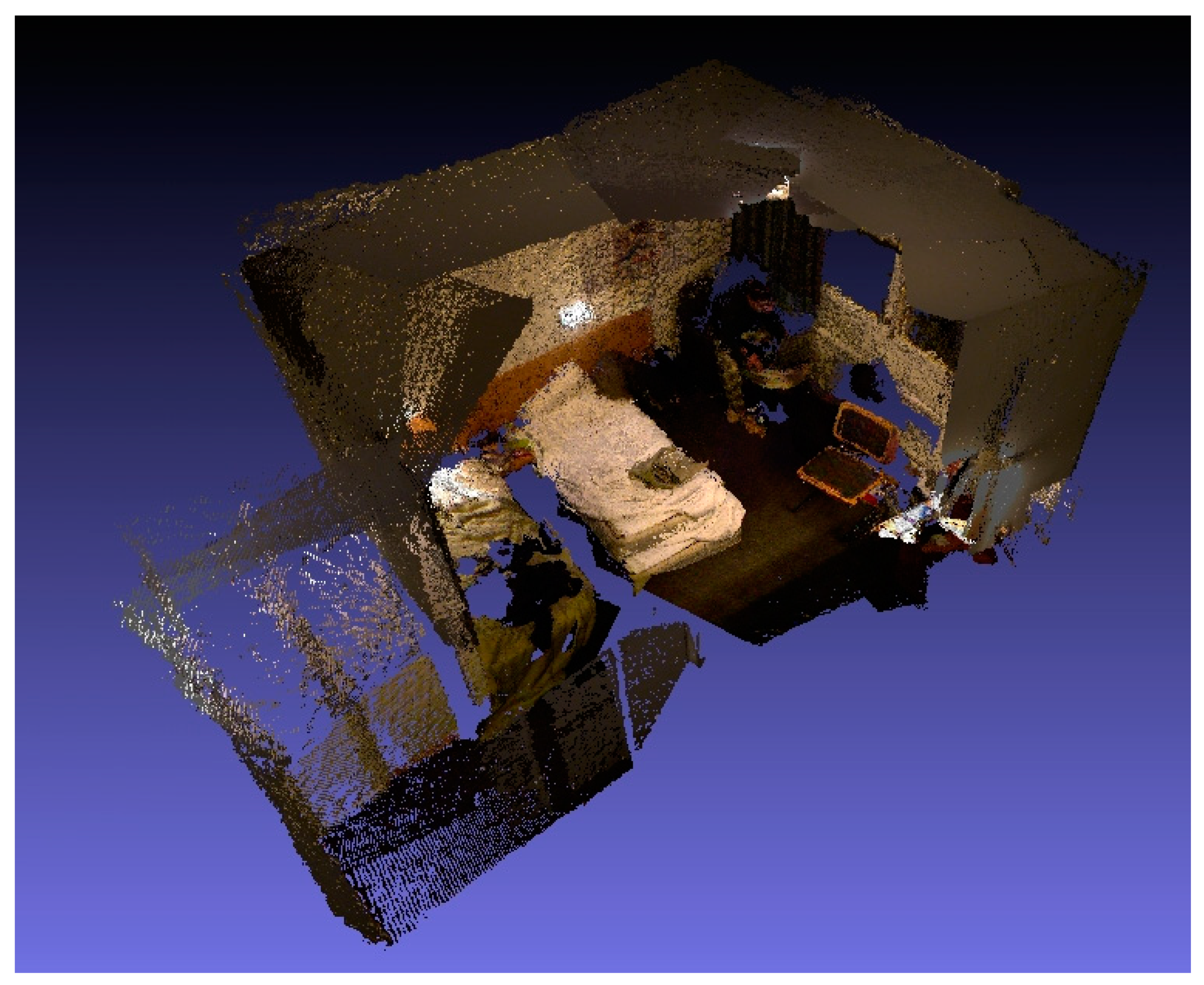
3. SLAM-Based Technologies

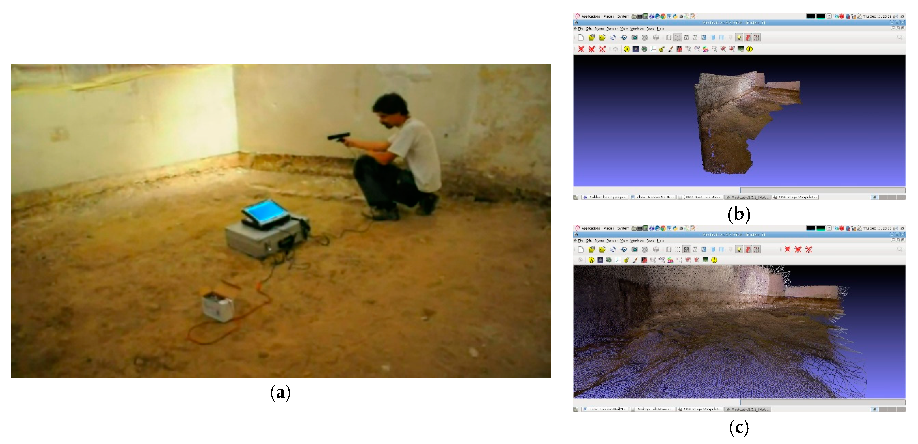
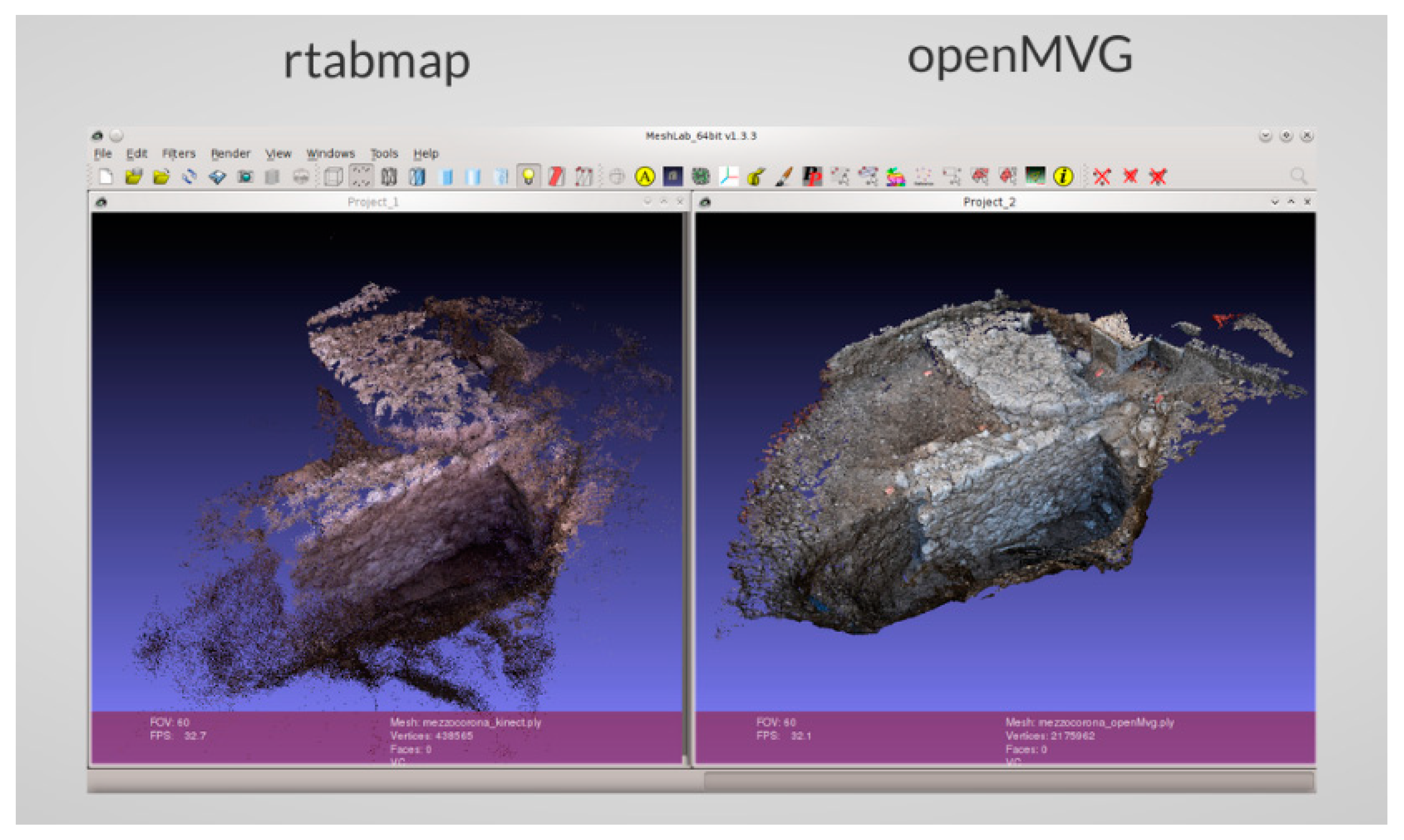
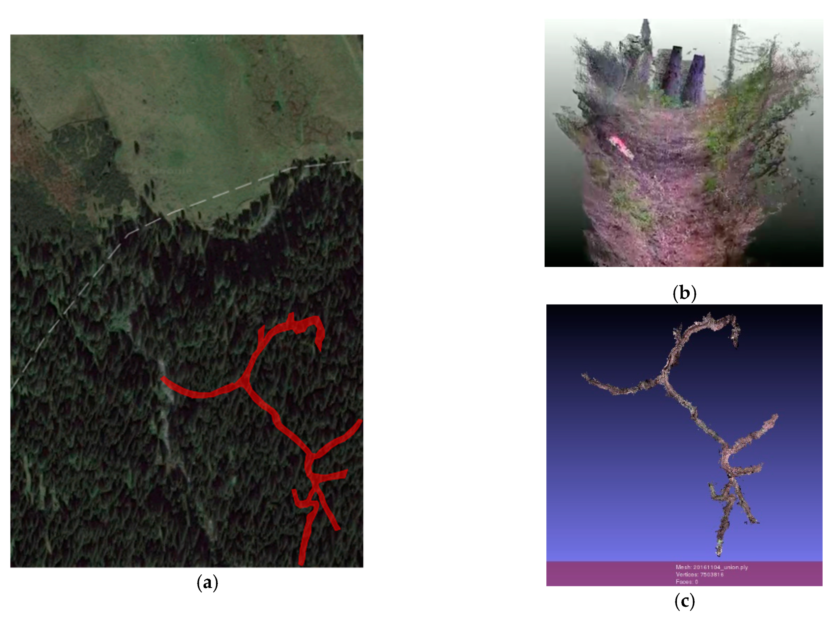
3.1. A New Approach to Real-Time 3D: Validation, Limitations and Its Potentialities

As previously mentioned, in 2016, Arc-Team started new experiments with the hardware Kinect [18]. This time, the research was oriented on archaeorobotics, in the attempt to find new solutions to equip some open hardware drones with 3D recording systems. At the beginning, the studies were oriented on the development of a ArcheoROV, a prototype of a ROV (remotely operated underwater vehicle), specifically designed for archaeological purposes [19].
The whole system was projected to work with the robotic suite ROS, using SLAM nodes both for orientation and 3D documentation. Even though in this case a Kinect was used simply as a testing tool to validate the technology since the infrared sensor could not work underwater, the positive result achieved encouraged a new test with the same platform: a laptop running a special version of ArcheOS with ROS and the SLAM node RtabMAp and a Kinect as a sensor device.
Obviously, such a platform, being based on RGBD cameras, still presents the same issues of the prototype with RGBDEmo and a Kinect even if the 3D recording process is significantly more responsive and it has potentially no limitations of the size of the recorded scene (due to the SLAM algorithms). Nevertheless, the main advantage of switching to a ROS system is represented by the wide range of possibilities both on the software (nodes) side and on the hardware (sensors) side. Indeed, within ROS, several open-source SLAM nodes can be used, such as RtabMap, LSD-SLAM, REMODE or Cartographer, just to name a few. In the same way, a ROS platform can be equipped with different sensors, overcoming the limitations of standalone software such as RGBDemo, specifically developed to work with a single hardware device. As an example, a ROS-based prototype could activate SLAM nodes connected with monocameras, stereocameras, a LIDAR or a sonar.
Apart from that, the level of accuracy and precision that can be achieved remains a strong limitation of this technology (Figure 7) as it is still not comparable to the SfM–MVS techniques. Moreover, SLAM is affected by a drift error: over time, the estimated motion starts deviating from the true motion. This is probably the main limitation of SLAM technologies, even if, in general, most software applications try to correct this issue with loop closure detection techniques. In other words, within ROS, a SLAM node can understand if the current 3D scene (location) has been previously recorded (visited) and, if so, it corrects the whole 3D model. However, despite these problems, the SLAM technique remains a valid option for real-time 3D in archaeology. Indeed, these limitations should be evaluated in relation to the archaeological tolerance of a project and, in many cases, a less precise and accurate 3D model could be acceptable if obtained under specific conditions, such as short-time acquisition, safety in the workplace, wide AoI (area of interest), etc. Precisely this kind of conditions is very important in professional archaeology.

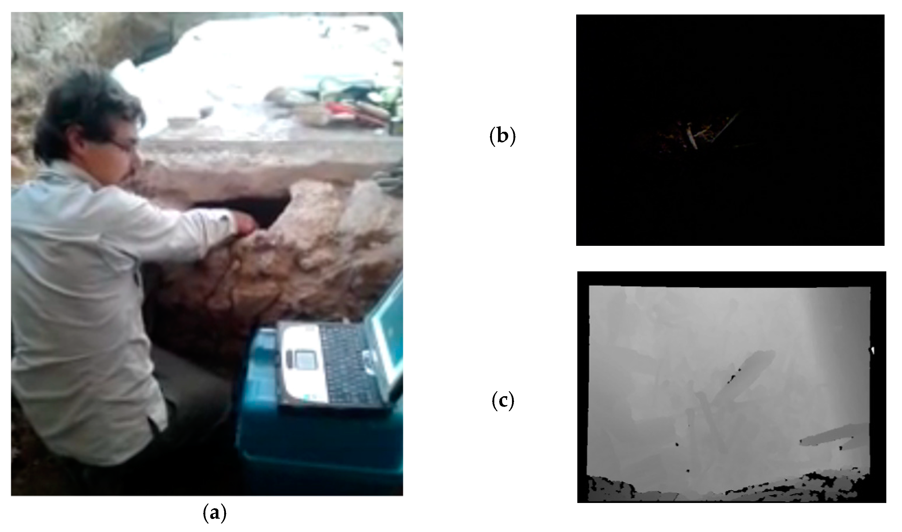
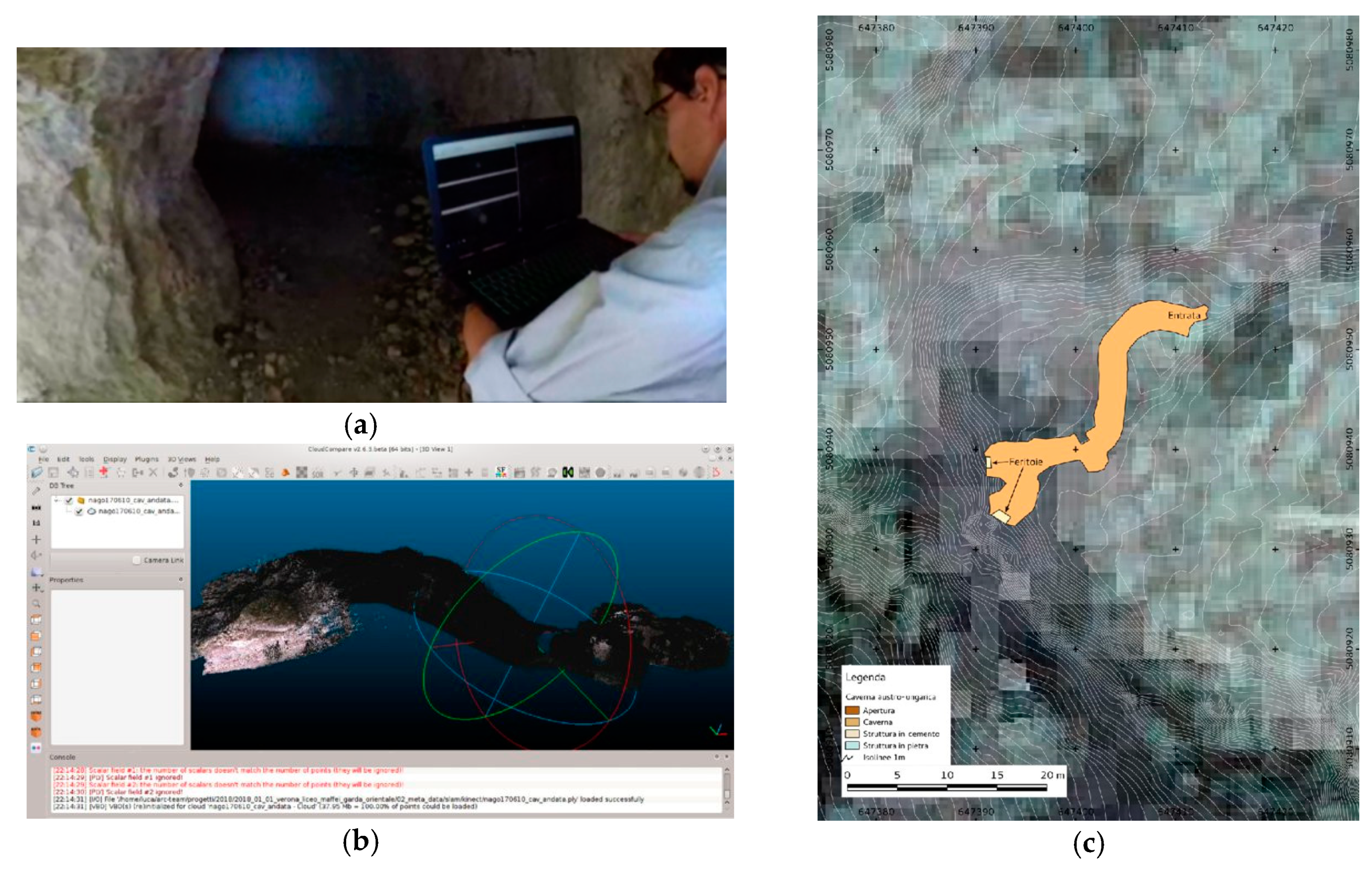
3.2. SLAM for Professional Archaeology

As anticipated, aside the on-board use of different kind of archaeorobotic drones (UAVs, ROVs, USVs, etc.), a platform equipped with ROS and various sensors is very useful in some peculiar situations that a professional archaeologist needs to face during their fieldwork. Basing on Arc-Team’s experience, this section reports some examples in which the SLAM technology represented the best strategy to accomplish specific tasks during archaeological projects.
The first case regards the documentation of negative excavations (trenches, sondages, etc.), which is normally required by several institutions for the protection of the cultural heritage (such as the Archaeological Superintendencies) to keep track of the recent underground working activities. For these cases, in the absence of archaeological evidence, the tolerance in 3D data recording is significantly high. Moreover, some specific environmental conditions may not allow the use of standard GNSS systems, which would speed up the geolocation process. This is exactly the case of a project which involved the archaeological assistance to an excavator, with negative result, in the S. Romedio gorge (Trentino, Italy), where no GPS signal could be reached. To accomplish the mission, a ROS platform with Kinect was used since there were no issues for direct sunlight illumination [20]. Three-dimensional acquisition of the field required less than an hour, as well as postprocessing operations. Indeed, the 3D model of the trench recorded with a calibrated device (Kinect) reported already metric values, so only the final step was necessary to achieve the correct geolocation: simple rototraslation on the 3D LIDAR model of the surrounding territory (released by the Autonomous Province of Trento as open geodata). This solution allowed reaching the final goal, avoiding more complex operations such as setting up radio bridges to use a differential GPS inside the gorge.
Similar conditions of high tolerance are often the standard parameters required during archaeological investigations through small sondages. This fact allows the operators in the field to perform 3D documentation with SLAM technologies, which are sufficiently fast to be compatible with the short schedules of web coworking [21]. In other words, the delay between 3D documentation in the field and data analyses in the laboratory can be significantly reduced with the adoption of SLAM technologies, allowing a better data-driven strategy during the excavation itself. In most cases, to avoid problems with direct sunlight illumination, a ROS-based platform can be equipped with sensors which do not require the infrared light, e.g., stereo cameras. For instance, this kind of prototype [22] was used by Arc-Team to perform some tests during an archaeological project aimed to explore the real extension of the Roman villa of Nonii Arrii in Calavino (Trentino, Italy) [23]. In that case, a Zed stereo camera was used in combination with RtabMap in order to register real-time 3D scenes of the archaeological sondages. This strategy noticeably reduced the time-consuming operation of 3D documentation, including due to the fact that the continuous recording of the stratigraphy of small archaeological sondages can be based on fixed GCPs placed outside the AoI, simplifying the geolocation.
However, the main benefits of SLAM systems have been experienced during extreme archaeology projects, and especially in the field of speleoarchaeology and mountain archaeology.
In the first case, SLAM-based devices can be used to quickly perform 3D documentation of small and medium-sized underground environments, particularly in the projects characterized by a high concentration of this kind of structures in a relatively small AoI. This situation was faced during a project of modern conflict archaeology aimed to 3D document and map evidence related to the Great War in the territory of Lake Garda [24]. Again, the adopted solution to document a high number of tunnels was the use of a Zed stereo camera and RtabMap (Figure 8). This strategy reduced the time spent underground, increasing work safety.
In the second case, mountain archaeology projects often have to deal with large territories covered by dense forests, at least under the treeline. In order to document minor archaeological evidence (with high tolerance), a SLAM system can be used to reduce the “scattering error” which affects GPS devices in such landscapes. For instance, Arc-Team used this technology to 3D document and map the traces left by several WWI trenches and some more ancient territorial boundaries in the woods between the Autonomous Province of Bozen/Bolzano and the Province of Belluno. The strategy presented two main advantages. On the one hand, the whole documentation was completed in just few hours of work; on the other hand, the problem of disturbed satellite signals was solved by placing some GCPs in the nearest clearing with the GPS, allowing the total station to enter the dense forest maintaining a geolocated link. In this case, without the possibility to use loop closure detection (due to the grass and dead leaves which cover the archaeological evidence), the drift error was controlled and reduced by dividing the documentation into small parts, around 10 m long, geolocated with the total station and some GCPs (Figure 9).

4. Conclusions

As shown in the previous sections, real-time 3D technologies can be very important in archaeology, especially during field projects such as excavations and surveys. In some common situations of professional activity such as investigation through delimited sondages, these technologies can noticeably reduce the scheduled time, allowing fast feedback from the laboratory and other web coworking strategies. On the other hand, in case of extreme archaeology projects, real-time 3D documentation can improve workplace safety. Based on Arc-Team’s experience, an old standalone application such as RGBDemo nowadays seems to be obsolete, while the most promising technologies are associated with more complex systems, e.g., ROS-based SLAM platforms. This second option gave the best results in the field, not to mention that it has strong repercussions on the development of new archaeorobotic devices. As a matter of fact, Arc-Team’s research in this field is currently oriented on better implementation of the SLAM system on board of different kinds of remotely operated vehicles, considering also the possibility to design an interchangeable platform based on a single-board computer (SBC) with ROS and several sensors. Such a platform could be mounted on different machines (UAVS, ROVs, USVs, etc.) or used aside by human operators. The first tests in this direction were positive, but only future improvement of SLAM technologies will be able to overcome the main problem of these systems: the drift error. Until then, for the most common archaeological operation, SLAM 3D acquisitions will not be competitive with respect to the SfM–MVS methodologies, at least in terms of precision and accuracy.

Supplementary Materials

All the materials used for this article are available online, with open licenses, at http://arc-team-open-research.blogspot.com.

Author Contributions

Conceptualization, L.B.; methodology, L.B., A.B. and K.F.; software, L.B.; validation, A.B., L.B., R.G., G.N. and K.F.; formal analysis, L.B., R.G., G.N. and K.F.; investigation, L.B.; data curation, R.G. and L.B.; writing—original draft preparation, L.B.; writing—review and editing, A.B.; visualization, L.B.; supervision, L.B.; project administration, L.B. All authors have read and agreed to the published version of the manuscript.

Funding

This research received no external funding.

Institutional Review Board Statement

Not applicable.

Informed Consent Statement

Not applicable.

Acknowledgments

Similarly to the related presentation made in 2019, this article is dedicated to the memory of our friend Matteo Delle Piane (Visual Computing Lab of CNR-ISTI). A great part of Arc-Team’s research on 3D technologies would not have been possible without the effort of Matteo in developing very important FLOSS such as MeshLab and 3DHop. The authors also want to thank Gianluca Fondriest for his help in testing infrared underground prospecting solutions.

Conflicts of Interest

The authors declare no conflict of interest.

References

  1. Simultaneous Localization and Mapping. Available online: https://en.wikipedia.org/w/index.php?title=Simultaneous_localization_and_mapping&oldid=1007538558 (accessed on 25 February 2021).
  2. Bezzi, A.; Bezzi, L.; Francisci, D.; Furnari, F. ArcheOS 4.0–“Caesar”: Novità e aspetti della distribuzione GNU/Linux dedicata all’archeologia. In Proceedings of the ArcheoFOSS. Free, Libre and Open Source Software e Open Format nei Processi di Ricerca Archeologica-Atti del VII Workshop, Rome, Italy, 11–13 June 2012; Serlorenzi, M., Ed.; All’Insegna del Giglio: Florence, Italy, 2013; pp. 165–173. [Google Scholar]
  3. Bezzi, L.; Bezzi, A.; Gietl, R.; Naponiello, G.; Feistmantl, K. Archeorobotics. Applicazioni robotiche aperte e archeologia estrema. In Proceedings of the ArcheoFOSS. Free, Libre and Open Source Software e Open Format nei Processi di Ricerca Archeologica–Atti del XII Workshop, Rome, Italy, 19–22 February 2018; Grossi, P., Costa, S., Jaja, A., Malatesta, S.G., Stasolla, F.R., Eds.; All’Insegna del Giglio: Florence, Italy, 2019; pp. 467–470. [Google Scholar]
  4. Archaeological Tolerance. Available online: http://arc-team-open-research.blogspot.com/2021/02/archaeological-tolerance.html (accessed on 26 February 2021).
  5. Kinect, Real Time 3D. Available online: http://arc-team-open-research.blogspot.com/2012/02/kinect-real-time-3d.html (accessed on 26 February 2021).
  6. Kinect Accuracy and Precision with RGBDemo. Available online: http://arc-team-open-research.blogspot.com/2012/03/kinect-accuracy-and-precision-with.html (accessed on 1 March 2021).
  7. Bezzi, A.; Bezzi, L.; Ducke, B. Computer Vision e Structure from Motion, nuove metodologie per la documentazione archeologica tridimensionale: Un approccio aperto. In Proceedings of the ArcheoFOSS. Free, Libre and Open Source Software e Open Format nei Processi di Ricerca Archeologica–Atti del V Workshop, Foggia, Italy, 6–7 May 2010; De Felice, G., Sibilano, M.G., Eds.; Edipuglia: Santo Spirito, Italy, 2011; pp. 103–111. [Google Scholar]
  8. Kinect 3D Limits: Documentation of Small Objects. Available online: http://arc-team-open-research.blogspot.com/2012/11/kinect-3d-limits-documentation-of-small.html (accessed on 1 March 2021).
  9. Bezzi, A.; Bezzi, L.; Moraes, C.; Carrara, N.; Tiziani, M. Analisi di uno studio open source: Il Taung Project. In Proceedings of the ArcheoFOSS. Free, Libre and Open Source Software e Open Format nei Processi di Ricerca Archeologica–Atti dell’VIII Workshop, Catania, Italy, 18–19 June 2013; Stanco, F., Gallo, G., Eds.; Archeopress: Oxford, UK, 2016; pp. 230–239. [Google Scholar]
  10. Kinect 3D Outdoor: Hacking the Hardware. Available online: http://arc-team-open-research.blogspot.com/2012/10/kinect-3d-outdoor-hacking-hardware.html (accessed on 2 March 2021).
  11. Bezzi, L.; Carrara, N.; Nebl, M. Imago Animi. Volti dal Passato, 1st ed.; Municipality of Cles: Cles, Italy, 2018. [Google Scholar]
  12. Kinect 3D Outdoor: First Test. Available online: http://arc-team-open-research.blogspot.com/2012/10/kinect-3d-outdoor-first-test.html (accessed on 2 March 2021).
  13. Dalla Mura, M.; Aravecchia, M.; Zanin, M. Outdoor 3D with Kinect: Preliminary resultsin the granulometry of fluvial sediments. In Proceedings of the Low Cost 3D: Sensori, Algoritmi e Applicazioni, Trento, Italy, 8–9 March 2012. [Google Scholar]
  14. Kinect 3D Indoor: Excavation Test. Available online: http://arc-team-open-research.blogspot.com/2012/10/kinect-3d-indoor-excavation-test.html (accessed on 2 March 2021).
  15. Cignoni, P.; Callieri, M.; Corsini, M.; Dellepiani, M.; Ganovelli, F.; Ranzuglia, G. MeshLab: An Open-Source Mesh Processing Tool. In Proceedings of the 6th Eurographics Italian Chapter Conference, Salerno, Italy, 2–4 July 2008; Scarano, V., De Chiara, R., Erra, U., Eds.; Eurographics Association: Aire-la-Ville, CH, USA, 2008; pp. 129–136. [Google Scholar]
  16. Kinect-Infrared Prospections. Available online: http://arc-team-open-research.blogspot.com/2013/06/kinect-infrared-prospections.html (accessed on 2 March 2021).
  17. A DIY Endoscope for Emergencies during Excavation Fieldwork. Available online: http://arc-team-open-research.blogspot.com/2011/07/diy-endoscpe-for-emergencies-during.html (accessed on 3 March 2021).
  18. Kinect, a Sleeping Research Branch Reacivated. Available online: http://arc-team-open-research.blogspot.com/2016/08/kinect-sleeping-research-branch.html (accessed on 3 March 2021).
  19. Bezzi, L.; Bezzi, A.; Nascivera, S.; Paissan, F.; Perghem, D.; Reyes, A.; Rocco, E.; Saiani, A. ArcheoROVUn ROV open hardware sviluppato specificatamente perscopi archeologici. In Proceedings of the ArcheoFOSS. Free, Libre and Open Source Software e Open Format nei Processi di Ricerca Archeologica–Atti dell’XI Workshop, Cagliari, Italy, 7–9 October 2016. (under review; accepted). [Google Scholar]
  20. ROS and Professional Archaeology. Available online: http://arc-team-open-research.blogspot.com/2017/04/ros-and-professional-archaeology.html (accessed on 3 March 2021).
  21. Bezzi, L.; Bezzi, A.; Boscaro, C.; Feistmantl, K.; Gietl, R.; Naponiello, G.; Ottati, F.; de Guzman, M. Commercial Archaeology and 3D WebTechnologies. JFA 2018, 43, 545–559. [Google Scholar] [CrossRef] [Green Version]
  22. ArcheOS Hypatia and Archeorobotics: ROS for 3D Dynamic Documentations. Available online: http://arc-team-open-research.blogspot.com/2017/04/archeos-hypatia-and-archeorobotics-ros.html (accessed on 3 March 2021).
  23. Bezzi, L.; Bezzi, A.; Gietl, R.; Feistmantl, K.; Naponiello, G. La villa romana dei Nonii Arrii a Toblino. Tecniche archeologiche applicate alla ricerca. AdA 2018, 4, 155–162. [Google Scholar]
  24. Bezzi, L.; Gietl, R.; Bonfanti, F.; Bezzi, A.; Naponiello, G.; Feistmantl, K. La Grande Guerra sul Garda orientale. Un progetto di archelogia del conflitto. In La Grande Guerra sul Garda Orientale. Operazioni Belliche e Vicende Militari sul lago e L’entroterra Montano, 1st ed.; Bonfanti, F., Ferrari, R., Eds.; Edibus: Vicenza, Italy, 2018; pp. 173–207. [Google Scholar]
Figure 1. Partial reconstruction of a room in Lund (Sparta guesthouse), performed as the first test with RGBDemo.
Environsciproc 10 00016 g001
Figure 2. The first test performed during the Taung Project. On the left (a), a cast of the Taung Child (green circle), a Kinect (red circle) and a laptop with ArcheOS and RGBDemo installed (blue circle); on the right: RGBDemo 3D real-time vision with uncovered areas due to close-range sensing (b) and the same 3D scene with an adequate distance from the target, but with low-resolution data (c).
Environsciproc 10 00016 g002
Figure 3. On the right (a), the Egyptian sarcophagus and the mummy within the showcase during the exhibition “Imago Animi. Volti dal passato” [11]; on the left (b), the 3D scene recorded during the Taung Project at the Anthropological Museum of Padua (the red circle underlines a transparent surface).
Environsciproc 10 00016 g003
Figure 4. A hacked Kinect (a); a natural cave with a direct sunlight spot (b); a 3D real-time model of the same cave, without the illuminated area (c).
Environsciproc 10 00016 g004
Figure 5. On the left (a), a real-time 3D documentation process during the excavation of the cathedral of Pordenone (Italy, 2012); on the right (b,c), the resulting 3D models loaded in the software MeshLab [15].
Environsciproc 10 00016 g005
Figure 6. On the left (a), infrared prospecting in Dorsino; on the right, the differences between the Kinect sensors in dark conditions: RGB (b), and infrared (c).
Environsciproc 10 00016 g006
Figure 7. A comparison between SLAM (on the left) and SfM–MVS (on the right) performed during a professional archaeological excavation in Mezzocorona (TN, Italy).
Environsciproc 10 00016 g007
Figure 8. On the left, SLAM operations inside a WWI tunnel near Lake Garda (a) and the respective 3D model (b); on the right, the map of the same tunnel obtained from the SLAM documentation (c).
Environsciproc 10 00016 g008
Figure 9. On the left, some WWI trenches in a dense forest area (a); on the right, a 3D SLAM model of a trench (b) and the final documentation of the whole trench system (c).
Environsciproc 10 00016 g009
Publisher’s Note: MDPI stays neutral with regard to jurisdictional claims in published maps and institutional affiliations.

