Revealing Unproductive Areas in the Caatinga Biome: A Remote Sensing Approach to Monitoring Land Degradation in Drylands
Abstract
1. Introduction
2. Materials and Methods
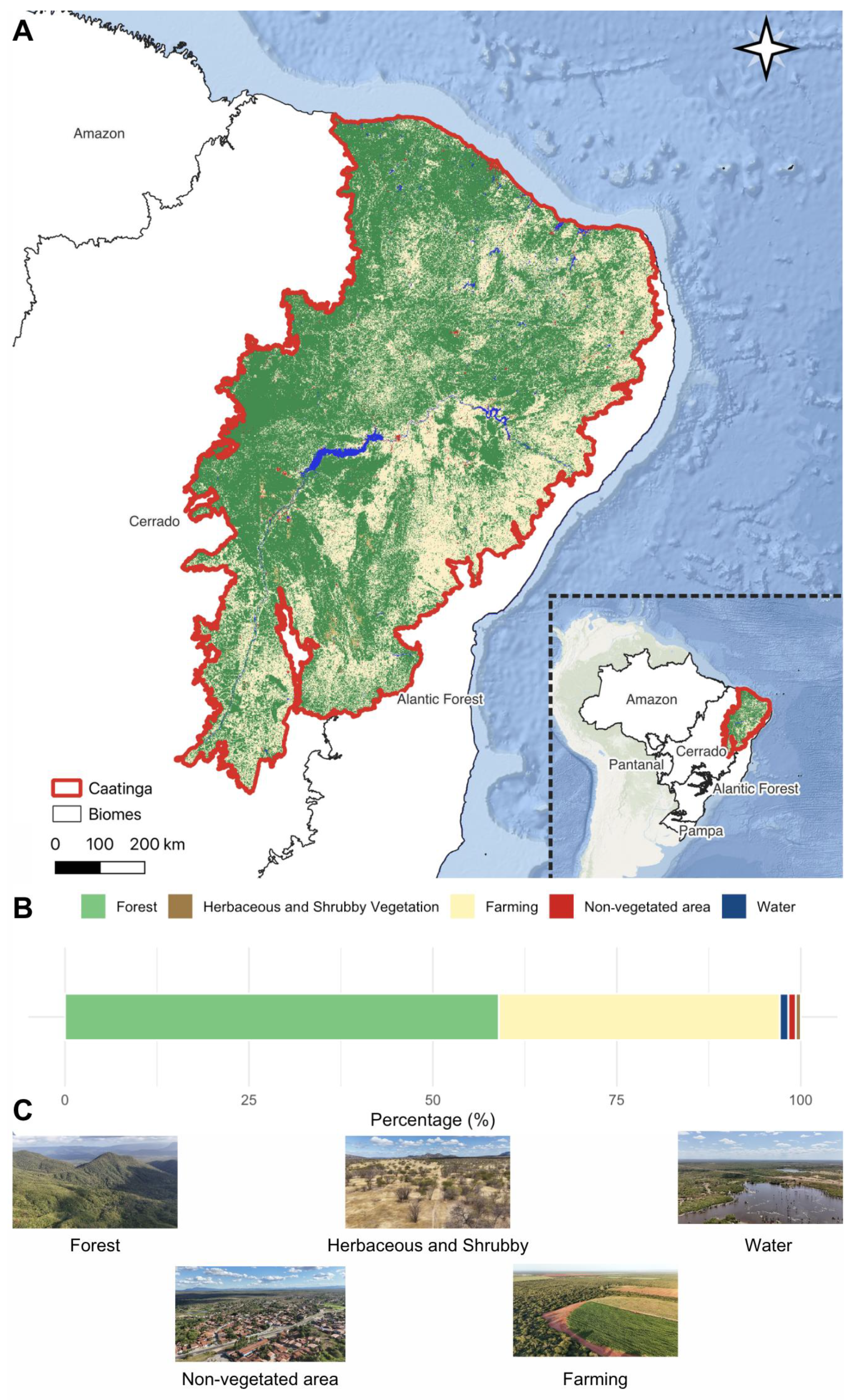
2.1. Study Area and Land Use/Land Cover Context
2.2. Data Preparation
2.3. Feature Space and Mosaic
2.4. Sample Design, Classification, and Results
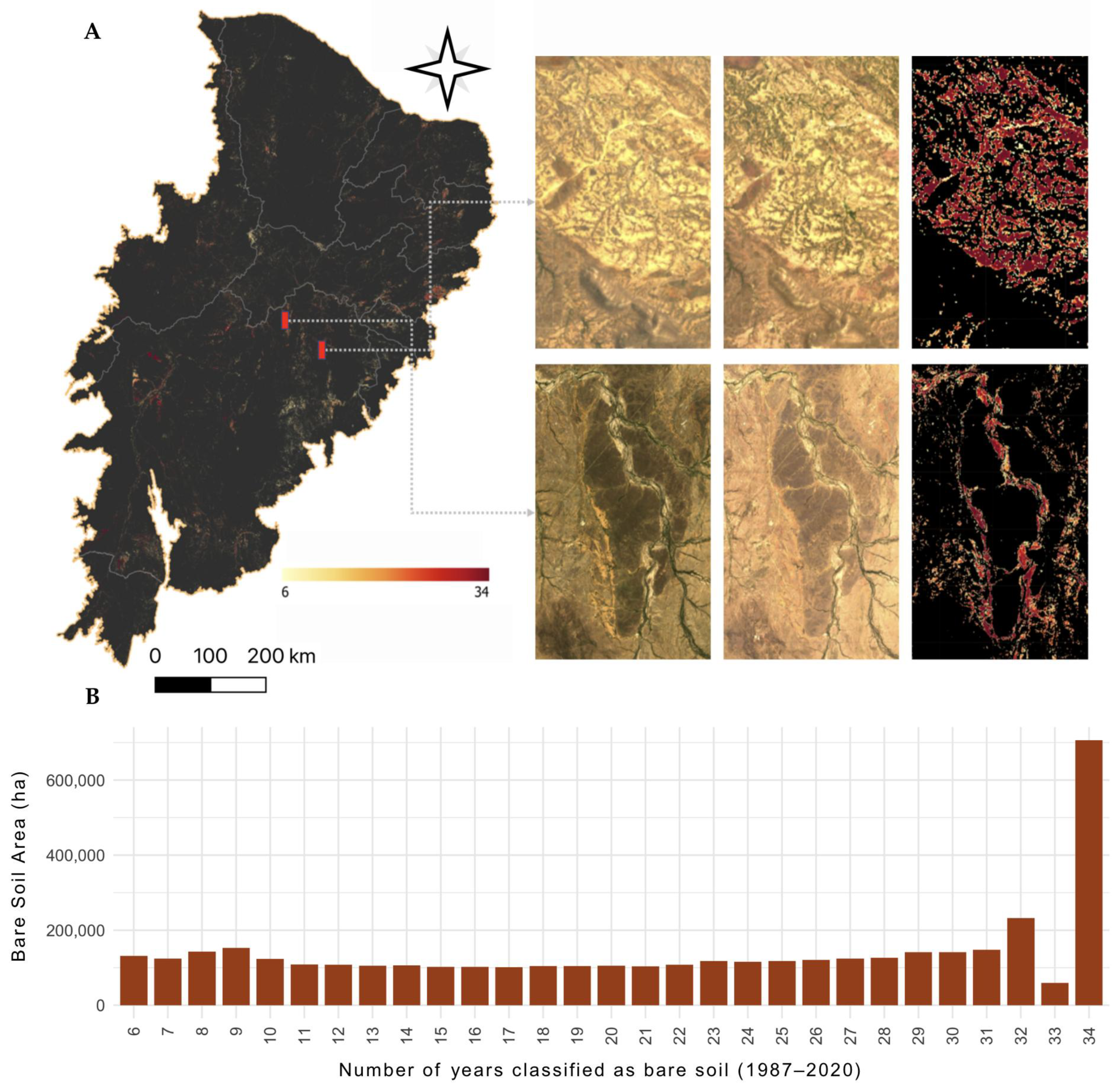
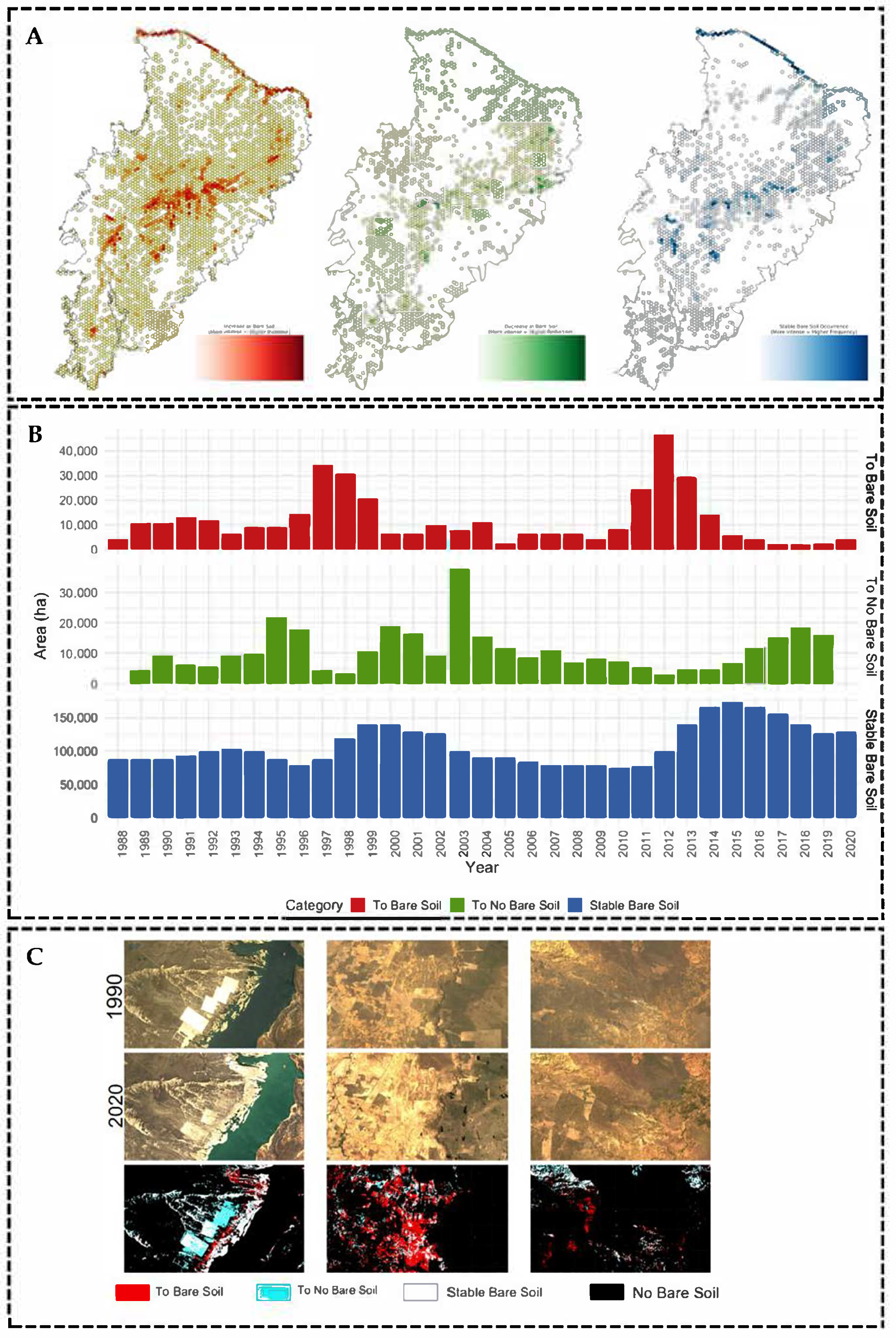
3. Results
4. Discussion
5. Conclusions
Supplementary Materials
Author Contributions
Funding
Data Availability Statement
Acknowledgments
Conflicts of Interest
References
- Costa, D.P.; Herrmann, S.M.; Vasconcelos, R.N.; Duverger, S.G.; Franca Rocha, W.J.S.; Cambuí, E.C.B.; Lobão, J.S.B.; Santos, E.M.R.; Ferreira-Ferreira, J.; Oliveira, M.; et al. Bibliometric Analysis of Land Degradation Studies in Drylands Using Remote Sensing Data: A 40-Year Review. Land 2023, 12, 1721. [Google Scholar] [CrossRef]
- Mirzabaev, A.; Stringer, L.C.; Benjaminsen, T.A.; Gonzalez, P.; Harris, R.; Jafari, M.; Stevens, N.; Tirado, C.M.; Zakieldeen, S. 2022: Cross-Chapter Paper 3: Deserts, Semiarid Areas and Desertification. In Climate Change 2022: Impacts, Adaptation and Vulnerability. Contribution of Working Group II to the Sixth Assessment Report of the Intergovernmental Panel on Climate Change; Pörtner, H.-O., Roberts, D.C., Tignor, M., Poloczanska, E.S., Mintenbeck, K., Alegría, A., Craig, M., Langsdorf, S., Löschke, S., Möller, V., et al., Eds.; Cambridge University Press: Cambridge, UK, 2019; pp. 2195–2231. [Google Scholar] [CrossRef]
- Smith, W.K.; Dannenberg, M.P.; Yan, D.; Herrmann, S.; Barnes, M.L.; Barron-Gafford, G.A.; Biederman, J.A.; Ferrenberg, S.; Fox, A.M.; Hudson, A.; et al. Remote Sensing of Dryland Ecosystem Structure and Function: Progress, Challenges, and Opportunities. Remote Sens. Environ. 2019, 233, 111401. [Google Scholar] [CrossRef]
- Herrmann, S.M.; Hutchinson, C.F. The Scientific Basis: Links between Land Degradation, Drought and Desertification. In Governing Global Desertification; Routledge: Oxford, UK, 2016; pp. 31–46. [Google Scholar]
- Rocha, F.; Rocha, W.J.S.F.; Vasconcelos, R.N.; Costa, D.P.; Duverger, S.G.; Lobão, J.S.B.; Souza, D.T.M.; Herrmann, S.M.; Santos, N.A.; Franca Rocha, R.O.; et al. Towards Uncovering Three Decades of LULC in the Brazilian Drylands: Caatinga Biome Dynamics (1985–2019). Land 2024, 13, 1250. [Google Scholar] [CrossRef]
- Costa, D.P.; Lentini, C.A.D.; Cunha Lima, A.T.; Duverger, S.G.; Vasconcelos, R.N.; Herrmann, S.M.; Ferreira-Ferreira, J.; Oliveira, M.; da Silva Barbosa, L.; Cordeiro, C.L.; et al. All Deforestation Matters: Deforestation Alert System for the Caatinga Biome in South America’s Tropical Dry Forest. Sustainability 2024, 16, 9006. [Google Scholar] [CrossRef]
- Marengo, J.A.; Galdos, M.V.; Challinor, A.; Cunha, A.P.; Marin, F.R.; Vianna, M.d.S.; Alvala, R.C.S.; Alves, L.M.; Moraes, O.L.; Bender, F. Drought in Northeast Brazil: A Review of Agricultural and Policy Adaptation Options for Food Security. Clim. Resil. Sustain. 2022, 1, e17. [Google Scholar] [CrossRef]
- Belgiu, M.; Drăgu, L. Random Forest in Remote Sensing: A Review of Applications and Future Directions. ISPRS J. Photogramm. Remote Sens. 2016, 114, 24–31. [Google Scholar] [CrossRef]
- Herrmann, S.M.; Brandt, M.; Rasmussen, K.; Fensholt, R. Accelerating Land Cover Change in West Africa over Four Decades as Population Pressure Increased. Commun. Earth Environ. 2020, 1, 53. [Google Scholar] [CrossRef]
- Robinove, C.J.; Chavez, P.S.; Gehring, D.; Holmgren, R. Arid Land Monitoring Using Landsat Albedo Difference Images. Remote Sens. Environ. 1981, 11, 133–156. [Google Scholar] [CrossRef]
- Graetz, R.D. Satellite Remote Sensing of Australian Rangelands. Remote Sens. Environ. 1987, 23, 313–331. [Google Scholar] [CrossRef]
- Kumar, L.; Mutanga, O. Google Earth Engine Applications since Inception: Usage, Trends, and Potential. Remote Sens. 2018, 10, 1509. [Google Scholar] [CrossRef]
- Gorelick, N.; Hancher, M.; Dixon, M.; Ilyushchenko, S.; Thau, D.; Moore, R. Google Earth Engine: Planetary-Scale Geospatial Analysis for Everyone. Remote Sens. Environ. 2017, 202, 18–27. [Google Scholar] [CrossRef]
- Sidhu, N.; Pebesma, E.; Câmara, G. Using Google Earth Engine to Detect Land Cover Change: Singapore as a Use Case Using Google Earth Engine to Detect Land Cover Change: Singapore as a Use. Eur. J. Remote Sens. 2018, 51, 486–500. [Google Scholar] [CrossRef]
- Souza, C.M.; Shimbo, J.Z.; Rosa, M.R.; Parente, L.L.; Alencar, A.A.; Rudorff, B.F.T.; Hasenack, H.; Matsumoto, M.; Ferreira, L.G.; Souza-Filho, P.W.M.; et al. Reconstructing Three Decades of Land Use and Land Cover Changes in Brazilian Biomes with Landsat Archive and Earth Engine. Remote Sens. 2020, 12, 2735. [Google Scholar] [CrossRef]
- Bullock, E.L.; Woodcock, C.E.; Olofsson, P. Monitoring Tropical Forest Degradation Using Spectral Unmixing and Landsat Time Series Analysis. Remote Sens. Environ. 2018, 238, 110968. [Google Scholar] [CrossRef]
- Souza, C.; Barreto, P. An Alternative Approach for Detecting and Monitoring Selectively Logged Forests in the Amazon. Int. J. Remote Sens. 2000, 21, 173–179. [Google Scholar] [CrossRef]
- Hansen, M.C.; Krylov, A.; Tyukavina, A.; Potapov, P.V.; Turubanova, S.; Zutta, B.; Ifo, S.; Margono, B.; Stolle, F.; Moore, R. Humid Tropical Forest Disturbance Alerts Using Landsat Data. Environ. Res. Lett. 2016, 11, 034008. [Google Scholar] [CrossRef]
- Sofan, P.; Vetrita, Y.; Yulianto, F.; Khomarudin, M.R. Multi-Temporal Remote Sensing Data and Spectral Indices Analysis for Detection Tropical Rainforest Degradation: Case Study in Kapuas Hulu and Sintang Districts, West Kalimantan, Indonesia. Nat. Hazards 2016, 80, 1279–1301. [Google Scholar] [CrossRef]
- Marengo, J.A.; Bernasconi, M. Regional Differences in Aridity/Drought Conditions over Northeast Brazil: Present State and Future Projections. Clim. Change 2015, 129, 103–115. [Google Scholar] [CrossRef]
- Lomax, G.A.; Powell, T.W.R.; Lenton, T.M.; Cunliffe, A.M. The Relative Productivity Index: Mapping Human Impacts on Rangeland Vegetation Productivity with Quantile Regression Forests. Ecol. Indic. 2025, 171, 113208. [Google Scholar] [CrossRef]
- Xie, H.; Zhang, Y.; Wu, Z.; Lv, T. A Bibliometric Analysis on Land Degradation: Current Status, Development, and Future Directions. Land 2020, 9, 28. [Google Scholar] [CrossRef]
- Wiethase, J.H.; Critchlow, R.; Foley, C.; Foley, L.; Kinsey, E.J.; Bergman, B.G.; Osujaki, B.; Mbwambo, Z.; Kirway, P.B.; Redeker, K.R.; et al. Pathways of Degradation in Rangelands in Northern Tanzania Show Their Loss of Resistance, but Potential for Recovery. Sci. Rep. 2023, 13, 2417. [Google Scholar] [CrossRef] [PubMed]
- Lehmann, J.; Kleber, M. The Contentious Nature of Soil Organic Matter. Nature 2015, 528, 60–68. [Google Scholar] [CrossRef] [PubMed]
- Stringer, L.C.; Reed, M.S. Land Degradation Assessment in Southern Africa: Integrating Local and Scientific Knowledge Bases. Land. Degrad. Dev. 2007, 18, 99–116. [Google Scholar] [CrossRef]
- Small, C.; Milesi, C. Multi-Scale Standardized Spectral Mixture Models. Remote Sens. Environ. 2013, 136, 442–454. [Google Scholar] [CrossRef]
- Souza, C.M.; Siqueira, J.V.; Sales, M.H.; Fonseca, A.V.; Ribeiro, J.G.; Numata, I.; Cochrane, M.A.; Barber, C.P.; Roberts, D.A.; Barlow, J. Ten-Year Landsat Classification of Deforestation and Forest Degradation in the Brazilian Amazon. Remote Sens. 2013, 5, 5493–5513. [Google Scholar] [CrossRef]
- Yang, J.; Weisberg, P.J.; Bristow, N.A. Landsat Remote Sensing Approaches for Monitoring Long-Term Tree Cover Dynamics in Semi-Arid Woodlands: Comparison of Vegetation Indices and Spectral Mixture Analysis. Remote Sens. Environ. 2012, 119, 62–71. [Google Scholar] [CrossRef]
- Antongiovanni, M.; Venticinque, E.M.; Fonseca, C.R. Fragmentation Patterns of the Caatinga Drylands. Landsc. Ecol. 2018, 33, 1353–1367. [Google Scholar] [CrossRef]
- Alencar, A.A.C.; Arruda, V.L.S.; da Silva, W.V.; Conciani, D.E.; Costa, D.P.; Crusco, N.; Duverger, S.G.; Ferreira, N.C.; Franca-Rocha, W.; Hasenack, H.; et al. Long-Term Landsat-Based Monthly Burned Area Dataset for the Brazilian Biomes Using Deep Learning. Remote Sens. 2022, 14, 2510. [Google Scholar] [CrossRef]
- Braga, A.; Laurini, M. Spatial Heterogeneity in Climate Change Effects across Brazilian Biomes. Sci. Rep. 2024, 14, 16414. [Google Scholar] [CrossRef]
- Leal, I.R.; Da Silva, J.M.C.; Tabarelli, M.; Lacher, T.E., Jr. Changing the Course of Biodiversity Conservation in the Caatinga of Northeastern Brazil. Wiley: Hoboken, NJ, USA, 2005. [Google Scholar]
- Araujo, H.F.P.; Canassa, N.F.; Machado, C.C.C.; Tabarelli, M. Human Disturbance Is the Major Driver of Vegetation Changes in the Caatinga Dry Forest Region. Sci. Rep. 2023, 13, 18440. [Google Scholar] [CrossRef]
- Roy, D.P.; Kovalskyy, V.; Zhang, H.K.; Vermote, E.F.; Yan, L.; Kumar, S.S.; Egorov, A. Characterization of Landsat-7 to Landsat-8 Reflective Wavelength and Normalized Difference Vegetation Index Continuity. Remote Sens. Environ. 2016, 185, 57–70. [Google Scholar] [CrossRef] [PubMed]
- Souza, C.M.; Roberts, D.A.; Cochrane, M.A. Combining Spectral and Spatial Information to Map Canopy Damage from Selective Logging and Forest Fires. Remote Sens. Environ. 2005, 98, 329–343. [Google Scholar] [CrossRef]
- Lentini, C.A.D.; Campos, E.J.D.; Podestá, G.G. The Annual Cycle of Satellite Derived Sea Surface Temperature on the Western South Atlantic Shelf. Rev. Bras. Oceanogr. 2000, 48, 93–105. [Google Scholar] [CrossRef]
- Demattê, J.A.M.; Safanelli, J.L.; Poppiel, R.R.; Rizzo, R.; Silvero, N.E.Q.; Mendes, W.d.S.; Bonfatti, B.R.; Dotto, A.C.; Salazar, D.F.U.; Mello, F.A. de O.; et al. Bare Earth’s Surface Spectra as a Proxy for Soil Resource Monitoring. Sci. Rep. 2020, 10, 4461. [Google Scholar] [CrossRef]
- da Silva Júnior, I.B.; da Silva Araújo, L.; Stosic, T.; Menezes, R.S.C.; da Silva, A.S.A. Space-Time Variability of Drought Characteristics in Pernambuco, Brazil. Water 2024, 16, 1490. [Google Scholar] [CrossRef]
- Cunha, A.P.M.A.; Zeri, M.; Leal, K.D.; Costa, L.; Cuartas, L.A.; Marengo, J.A.; Tomasella, J.; Vieira, R.M.; Barbosa, A.A.; Cunningham, C.; et al. Extreme Drought Events over Brazil from 2011 to 2019. Atmosphere 2019, 10, 642. [Google Scholar] [CrossRef]
- Marengo, J.A.; Cunha, A.P.M.A.; Nobre, C.A.; Ribeiro Neto, G.G.; Magalhaes, A.R.; Torres, R.R.; Sampaio, G.; Alexandre, F.; Alves, L.M.; Cuartas, L.A.; et al. Assessing Drought in the Drylands of Northeast Brazil under Regional Warming Exceeding 4 °C. Nat. Hazards 2020, 103, 2589–2611. [Google Scholar] [CrossRef]
- Marengo, J.A.; Alves, L.M.; Alvala, R.C.S.; Cunha, A.P.; Brito, S.; Moraes, O.L.L. Climatic Characteristics of the 2010-2016 Drought in the Semiarid Northeast Brazil Region. An Acad Bras Cienc 2018, 90, 1973–1985. [Google Scholar] [CrossRef]
- de Barros de Sousa, L.; de Assunção Montenegro, A.A.; da Silva, M.V.; Almeida, T.A.B.; de Carvalho, A.A.; da Silva, T.G.F.; de Lima, J.L.M.P. Spatiotemporal Analysis of Rainfall and Droughts in a Semiarid Basin of Brazil: Land Use and Land Cover Dynamics. Remote Sens. 2023, 15, 2550. [Google Scholar] [CrossRef]
- Tomasella, J.; de A. Cunha, A.P.; Marengo, J.A. Nota Técnica: Elaboração dos Mapas de índice de Aridez e Precipitação Total Acumulada para o Brasil. Available online: https://www.gov.br/cemaden/pt-br/assuntos/noticias-cemaden/estudo-do-cemaden-e-do-inpe-identifica-pela-primeira-vez-a-ocorrencia-de-uma-regiao-arida-no-pais/nota-tecnica_aridas.pdf (accessed on 29 November 2023).
- Sun, T.; Ferreira, V.G.; He, X.; Andam-Akorful, S.A. Water Availability of São Francisco River Basin Based on a Space-Borne Geodetic Sensor. Water 2016, 8, 213. [Google Scholar] [CrossRef]
- Andrade, C.; de Souza, I.; da Silva, L. The Future Sustainability of the São Francisco River Basin in Brazil: A Case Study. Sustainability 2024, 16, 5521. [Google Scholar] [CrossRef]
- Paredes-Trejo, F.; Barbosa, H.A.; Daldegan, G.A.; Teich, I.; García, C.L.; Kumar, T.V.L.; Buriti, C.d.O. Impact of Drought on Land Productivity and Degradation in the Brazilian Semiarid Region. Land 2023, 12, 954. [Google Scholar] [CrossRef]
- Jardim, A.M.d.R.F.; Araújo Júnior, G.D.N.; da Silva, M.V.; Dos Santos, A.; da Silva, J.L.B.; Pandorfi, H.; de Oliveira-Júnior, J.F.; Teixeira, A.H.d.C.; Teodoro, P.E.; de Lima, J.L.M.P.; et al. Using Remote Sensing to Quantify the Joint Effects of Climate and Land Use/Land Cover Changes on the Caatinga Biome of Northeast Brazilian. Remote Sens. 2022, 14, 1911. [Google Scholar] [CrossRef]
- Abdelfattah, M.A. Land Degradation Indicators and Management Options in the Desert Environment of Abu Dhabi, United Arab Emirates. Soil. Horizons 2009, 50, 3–10. [Google Scholar] [CrossRef]
- Foody, G.M. Status of Land Cover Classification Accuracy Assessment. Remote Sens. Environ. 2002, 80, 185–201. [Google Scholar] [CrossRef]


Disclaimer/Publisher’s Note: The statements, opinions and data contained in all publications are solely those of the individual author(s) and contributor(s) and not of MDPI and/or the editor(s). MDPI and/or the editor(s) disclaim responsibility for any injury to people or property resulting from any ideas, methods, instructions or products referred to in the content. |
© 2025 by the authors. Licensee MDPI, Basel, Switzerland. This article is an open access article distributed under the terms and conditions of the Creative Commons Attribution (CC BY) license (https://creativecommons.org/licenses/by/4.0/).
Share and Cite
Costa, D.P.; Vasconcelos, R.N.; Duverger, S.G.; Herrmann, S.M.; Franca Rocha, W.J.S.; Santos, N.A.; Souza, D.T.M.; Cunha Lima, A.T.; Lentini, C.A.D. Revealing Unproductive Areas in the Caatinga Biome: A Remote Sensing Approach to Monitoring Land Degradation in Drylands. Earth 2025, 6, 96. https://doi.org/10.3390/earth6030096
Costa DP, Vasconcelos RN, Duverger SG, Herrmann SM, Franca Rocha WJS, Santos NA, Souza DTM, Cunha Lima AT, Lentini CAD. Revealing Unproductive Areas in the Caatinga Biome: A Remote Sensing Approach to Monitoring Land Degradation in Drylands. Earth. 2025; 6(3):96. https://doi.org/10.3390/earth6030096
Chicago/Turabian StyleCosta, Diêgo P., Rodrigo N. Vasconcelos, Soltan Galano Duverger, Stefanie M. Herrmann, Washington J. S. Franca Rocha, Nerivaldo Afonso Santos, Deorgia T. M. Souza, André T. Cunha Lima, and Carlos A. D. Lentini. 2025. "Revealing Unproductive Areas in the Caatinga Biome: A Remote Sensing Approach to Monitoring Land Degradation in Drylands" Earth 6, no. 3: 96. https://doi.org/10.3390/earth6030096
APA StyleCosta, D. P., Vasconcelos, R. N., Duverger, S. G., Herrmann, S. M., Franca Rocha, W. J. S., Santos, N. A., Souza, D. T. M., Cunha Lima, A. T., & Lentini, C. A. D. (2025). Revealing Unproductive Areas in the Caatinga Biome: A Remote Sensing Approach to Monitoring Land Degradation in Drylands. Earth, 6(3), 96. https://doi.org/10.3390/earth6030096


