Article

Mangrove Ecosystems in the Maldives: A Nationwide Assessment of Diversity, Habitat Typology and Conservation Priorities

by
Aishath Ali Farhath
1,2,*,
S. Bijoy Nandan
1,
Suseela Sreelekshmi
1,
Mariyam Rifga
2,
Ibrahim Naeem
3,
Neduvelil Regina Hershey
1 and
Remy Ntakirutimana
2,4
1
Department of Marine Biology, Microbiology and Biochemistry, School of Marine Sciences, Cochin University of Science and Technology, Kochi 682016, India
2
Maldives Wetlands Foundation, Male’ Grand, 208, Malé P.O. Box 20162, Maldives
3
Environmental Protection Agency, Malé P.O. Box 20392, Maldives
4
School of Industrial Fisheries, Cochin University of Science and Technology, Kochi 682016, India
*
Author to whom correspondence should be addressed.
Earth 2025, 6(3), 66; https://doi.org/10.3390/earth6030066
Submission received: 22 May 2025 / Revised: 11 June 2025 / Accepted: 27 June 2025 / Published: 1 July 2025

Abstract

This study presents the first comprehensive nationwide assessment of mangrove ecosystems in the Maldives. Surveys were conducted across 162 islands in 20 administrative atolls, integrating field data, the literature, and secondary sources to map mangrove distribution, confirm species presence, and classify habitat types. Twelve true mangrove species were identified, with Bruguiera cylindrica, Rhizophora mucronata, and Lumnitzera racemosa emerging as dominant. Species diversity was evaluated using Shannon (H′), Margalef (d′), Pielou’s evenness (J′), and Simpson’s dominance (λ′) indices. Atolls within the northern and southern regions, particularly Laamu, Noonu, and Shaviyani, exhibited the highest diversity and evenness, while central atolls such as Ari and Faafu supported mono-specific or degraded stands. Mangrove habitats were classified into four geomorphological types: marsh based, pond based, embayment, and fringing systems. Field sampling was conducted using standardized belt transects and quadrats, with species verified using photographic documentation and expert validation. Species distributions showed strong habitat associations, with B. cylindrica dominant in marshes, R. mucronata and B. gymnorrhiza in ponds, and Ceriops tagal and L. racemosa in embayments. Rare species like Bruguiera hainesii and Heritiera littoralis were confined to stable hydrological niches. This study establishes a critical, island-level baseline for mangrove conservation and ecosystem-based planning in the Maldives, providing a reference point for tracking future responses to climate change, sea-level rise, and hydrological disturbances, emphasizing the need for habitat-specific strategies to protect biodiversity.

1. Introduction

Mangrove forests are among the most ecologically unique and valuable components of coastal ecosystems, comprising woody trees and shrubs adapted to intertidal zones of tropical and subtropical regions [1,2,3]. These plants, derived from diverse flowering families [4], exhibit specialized adaptations, such as complex root structures, viviparous reproduction and salt secretion systems, that enable survival in dynamic saline environments [5,6]. Globally, mangrove habitats are distributed across 124 tropical and subtropical nations between 30° N and 30° S latitudes [7,8]. Taxonomically, mangrove flora is classified into two functional groups: (1) true mangroves, comprising over 65 species from 20 families that exhibit specialized adaptations for intertidal zones; and (2) mangrove associates, over 120 species that occur in adjacent transitional habitats but without the full suite of specialized traits [8,9]. As one of the most productive ecosystems on Earth, these forests deliver vital ecological and socioeconomic services [10,11]. These include coastal stabilization, nutrient cycling, and acting as nursery grounds and biodiversity hotspots for numerous marine and terrestrial organisms [12,13]. Mangroves also sequester carbon at rates exceeding those of most terrestrial forests, making them critical to global climate regulation [14]. For many coastal communities, they provide livelihoods through fisheries, ecotourism, and the harvesting of timber and non-timber forest products [15,16]. Despite their importance, mangroves are increasingly threatened by anthropogenic and climate-related pressures. Between 1996 and 2020, global mangrove cover experienced a net loss of 3.4% (5245 km2), primarily driven by coastal development, aquaculture, agriculture, pollution, and unsustainable resource extraction [2,17]. These pressures are compounded by climate change-induced stressors, such as sea-level rise, altered wave regimes, and increased storm activity [18]. Their narrow and dynamic distribution in intertidal zones further exacerbates their vulnerability, underscoring the need for urgent conservation and management efforts [11]. Extensive global research has documented mangrove distribution [7,9,19,20], but studies focusing on small, fragmented mangrove patches remain limited [21]. These smaller patches are especially vital for low-lying Small Island Developing States (SIDSs), where mangroves provide outsized protective and ecological functions relative to their size [22,23]. In archipelagic nations like the Maldives, mangroves are intimately linked with adjacent ecosystems such as coral reefs and play a critical role in local coastal resilience. However, the leasing of islands for development projects is contributing to rapid mangrove loss, jeopardizing these fragile ecosystems [12,24,25]. To date, no nationwide assessment of mangroves in the Maldives has been undertaken, largely due to practical challenges. The country’s geography, comprising over 1000 small, dispersed islands, makes traditional ground surveys logistically complex and financially prohibitive. Additionally, satellite-based remote sensing technologies often fail to detect smaller or fragmented mangrove patches due to scale and resolution limitations. Consequently, many mangrove-bearing islands remain unmapped and under threat. This study seeks to address this critical knowledge gap by conducting the first systematic nationwide assessment of mangrove distribution and status across the Maldives. This urgency was underscored by the widespread mangrove dieback reported across several Maldivian atolls during the extreme Indian Ocean Dipole event in 2020. The authors of [25] attributed this dieback to salinity stress driven by record-high sea levels, particularly in pond- and basin-type systems. Elevated soil salinity, sea-level anomalies, and prolonged drought, linked to the Indian Ocean Dipole (IOD) and a triple La Niña, were identified as significant drivers of mortality in hydrologically restricted habitats [26]. By integrating published and grey literature, citizen science contributions, and targeted field surveys, this study aims to map and classify mangrove habitats, validate species presence using strict criteria, and account for island habitation status. The resulting baseline dataset is intended to support improved monitoring, conservation prioritization, and sustainable management of mangrove ecosystems in the country.

2. Materials and Methods
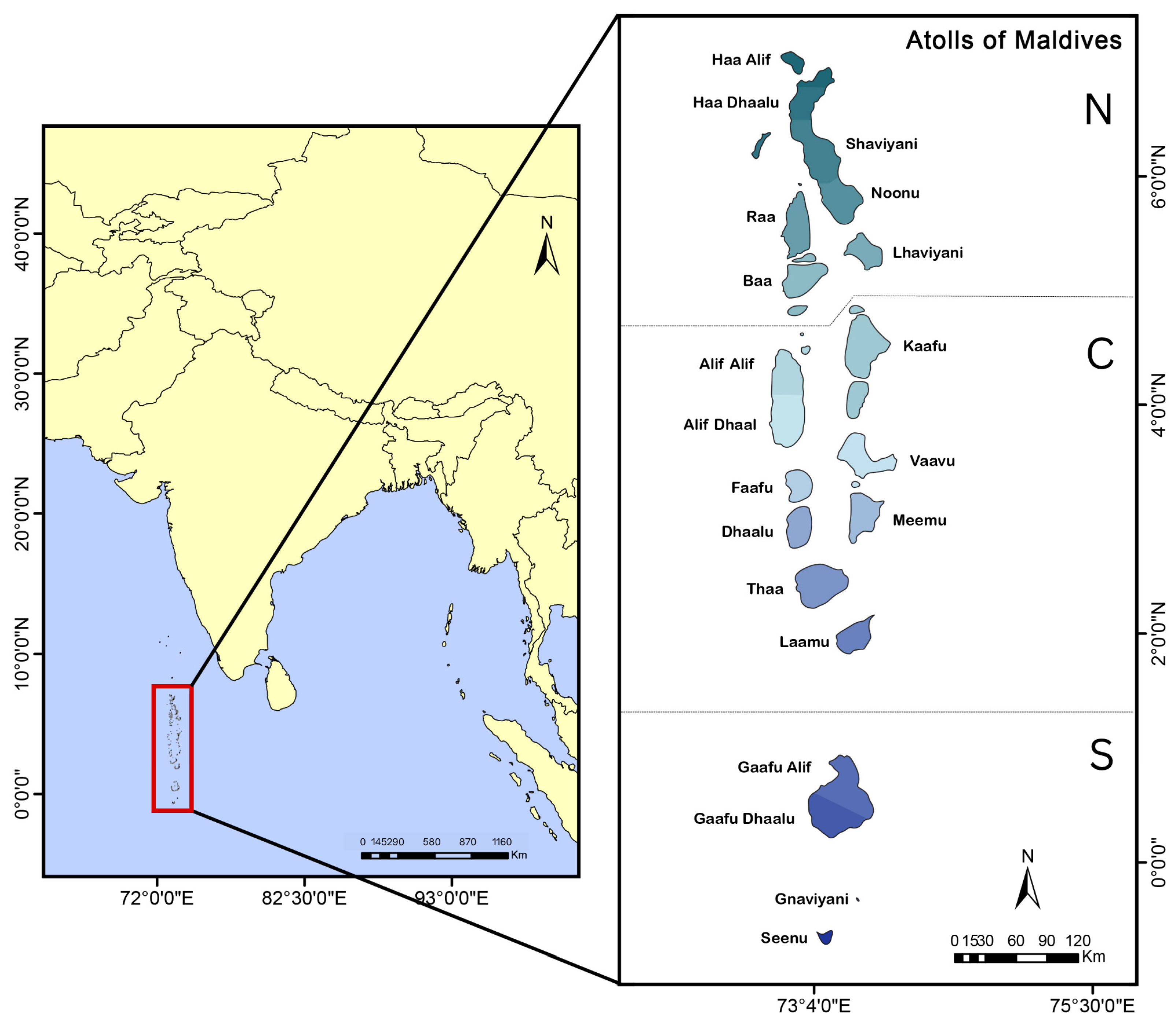
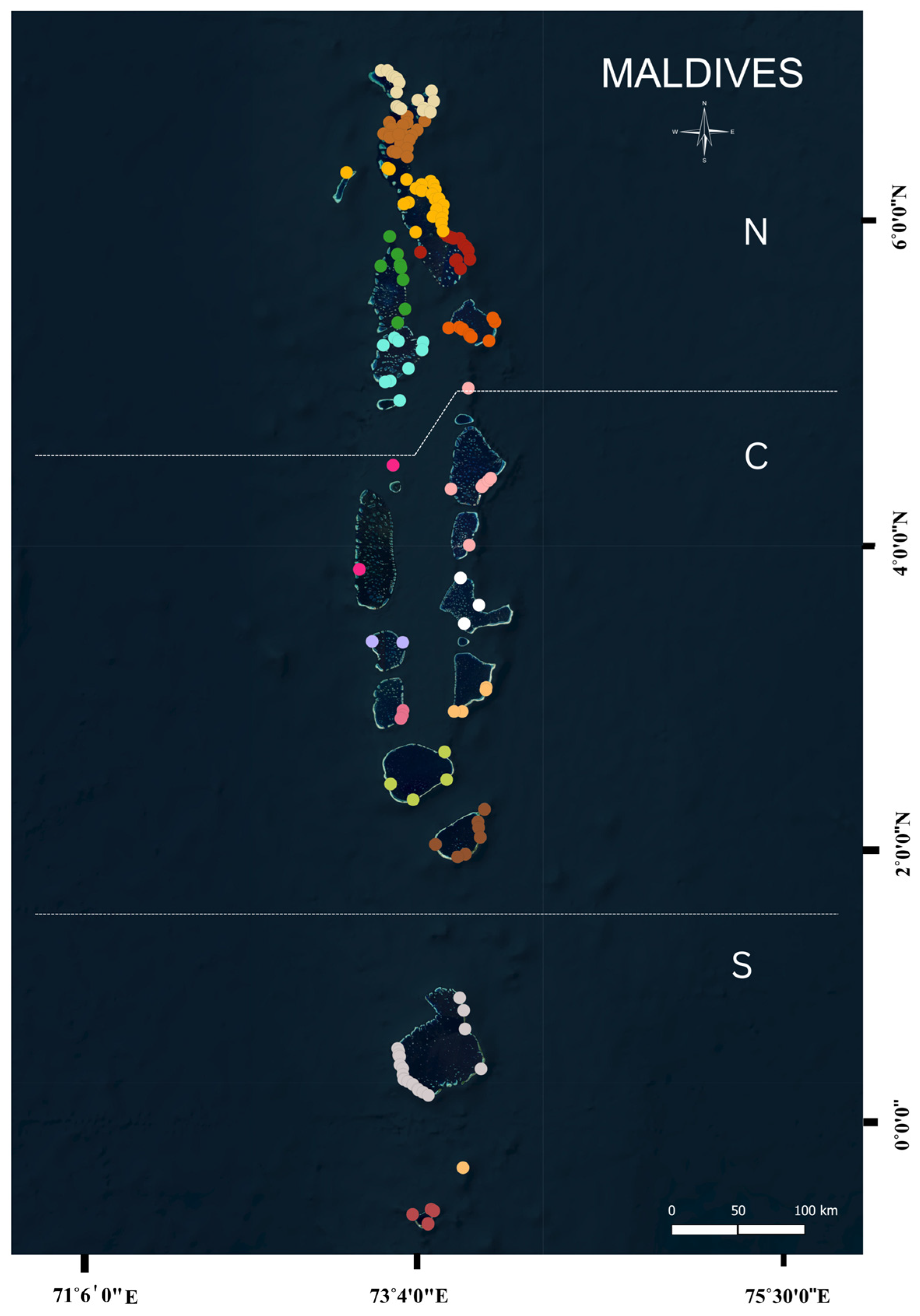
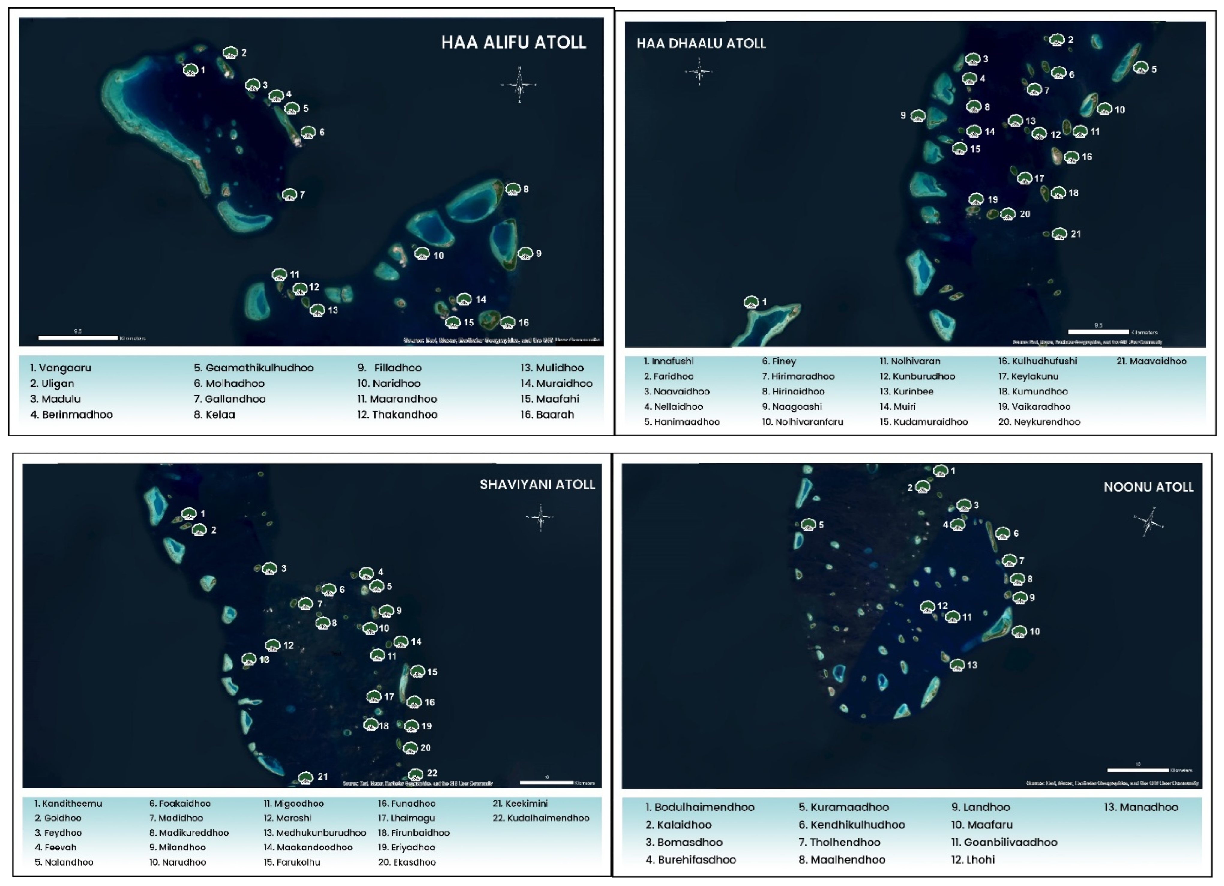
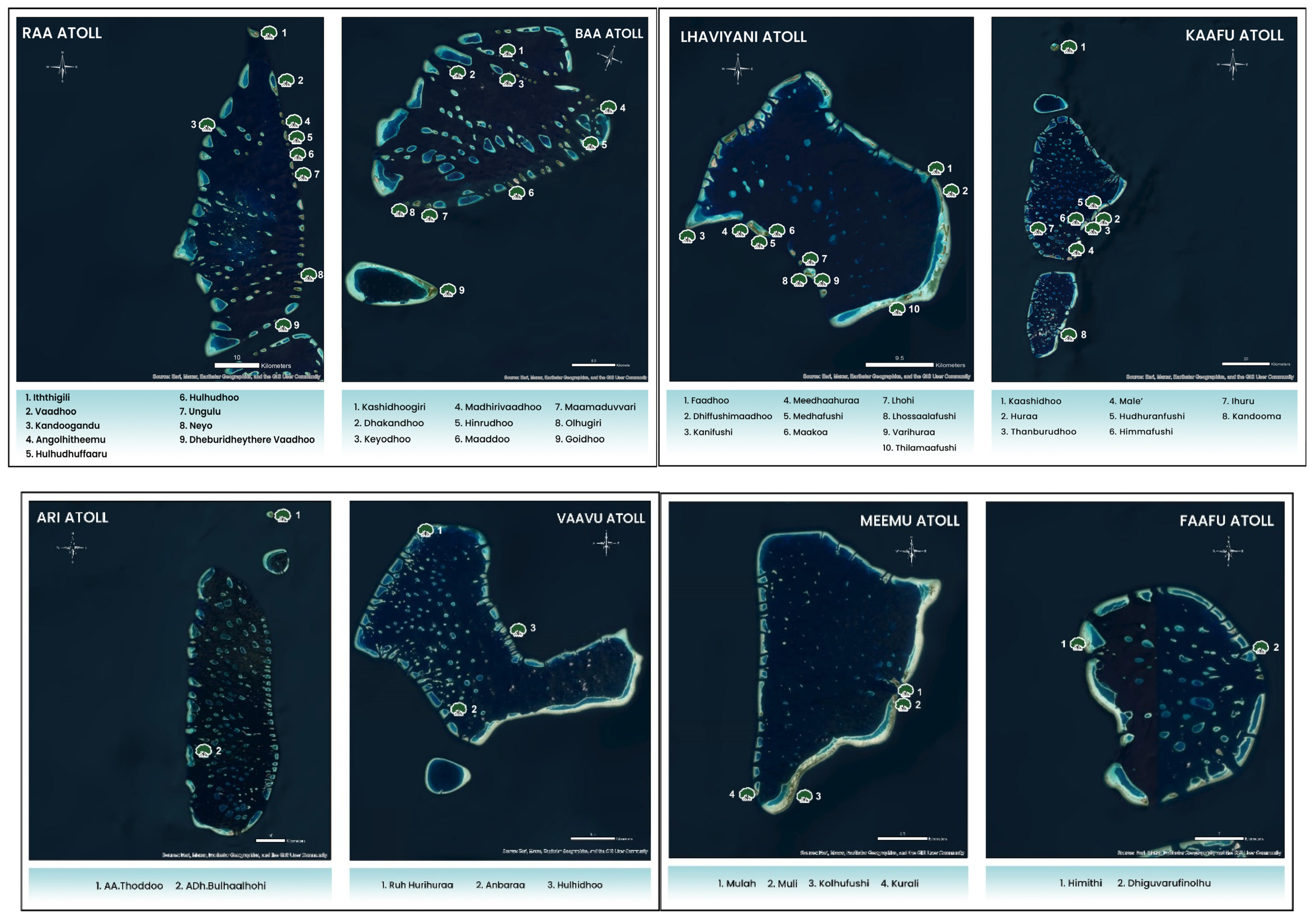
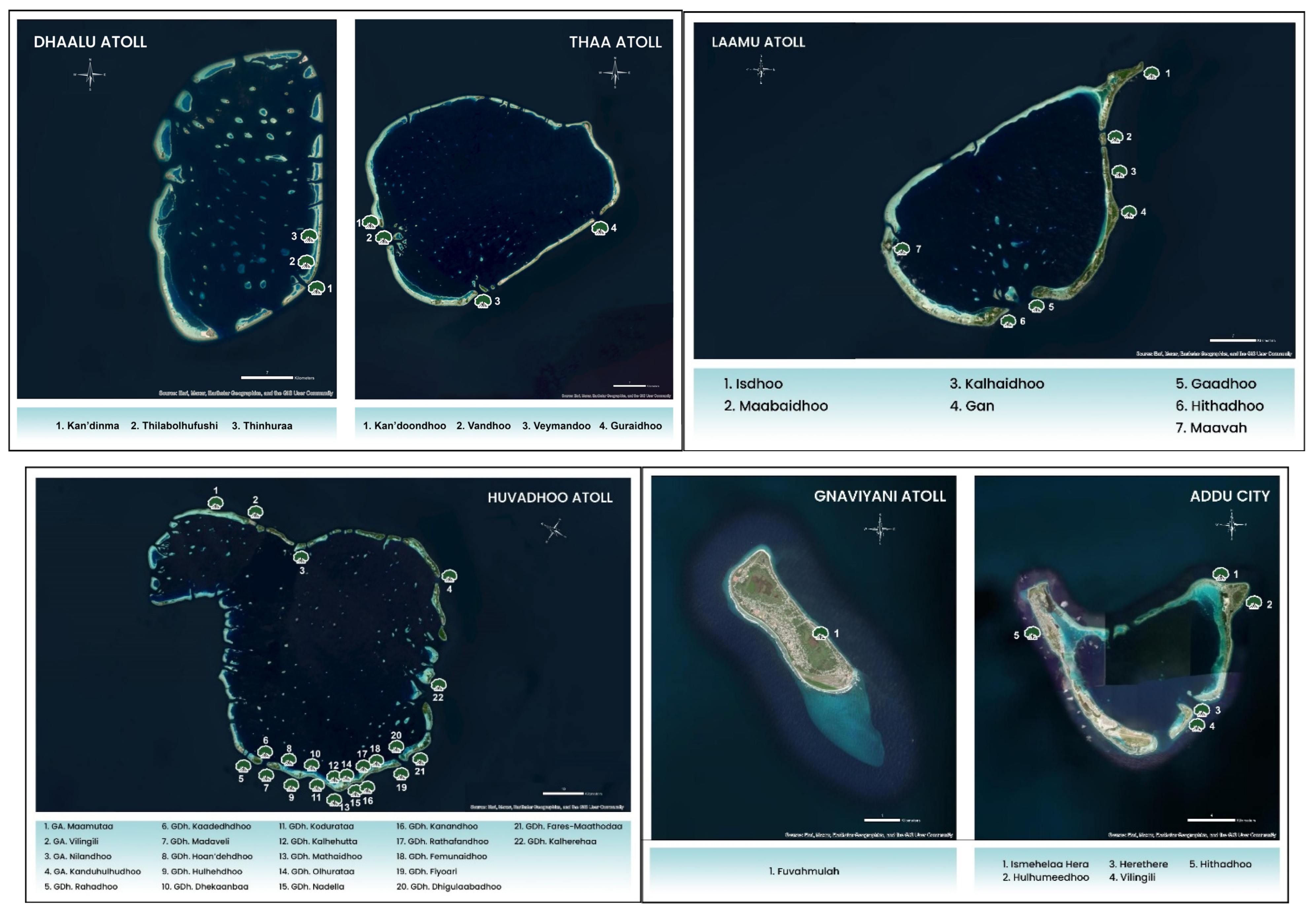
2.1. Study Area

This study was conducted across all 20 administrative atolls of the Maldives, encompassing a range of mangrove ecosystem types, including basin (marsh-based), embayment, pond, and fringe systems. The Maldives is a low-lying island nation in the Indian Ocean, made up of 26 natural atolls and 1192 coral islands, stretching about 870 km from north to south. With an average elevation of around 1.5 m above sea level [25], the country’s low height above sea level affects where mangroves can grow by influencing tidal flooding, salt levels, and exposure to changes in sea level. The country’s spatially fragmented geography, with mangrove habitats scattered across both inhabited and uninhabited islands, presents unique ecological and logistical challenges (Figure 1). To account for this heterogeneity, a stratified, island-level sampling approach was adopted to capture both atoll-scale and habitat-level variations in mangrove species composition. Island selection was based on satellite imagery, local ecological knowledge, existing national datasets, and prior field observations to ensure comprehensive coverage of mangrove-bearing sites. For spatial comparison, the 20 administrative atolls were further grouped into three broad geographic zones based on their latitudinal position within the archipelago: northern atolls (Haa Alif, Haa Dhaalu, Shaviyani, Noonu, Raa, Baa, Lhaviyani), central atolls (Kaafu, Alif Alif, Alif Dhaalu, Vaavu, Meemu, Faafu, Dhaalu, Thaa, Laamu), and southern atolls (Gaafu Alif, Gaafu Dhaalu, Gnaviyani, and Seenu/Addu). These regional groupings, as shown in Figure 1, were used to compare large-scale spatial trends in mangrove distribution and diversity across the country.

2.2. Data Collection Method

Mangrove inventories were conducted from July 2022 to July 2024 using a standardized belt transect sampling approach, specifically adapted to accommodate the geomorphological diversity and spatial limitations of small island ecosystems. On each island, one or more belt transects (10 m wide) were established perpendicular to the shoreline, spanning the full width of the mangrove stand to ensure comprehensive representation of habitat zones and mangrove species distribution.
Within each transect, 10 × 10 m quadrats were established at regular intervals to record species identity and stem count (abundance). The focus of data collection was on species composition and their geographic occurrence across islands and atolls. In instances where mangrove patches were too narrow or spatially limited to accommodate full transects, a modified plot-based sampling method was applied. This approach involved placing quadrats strategically across the patch while maintaining consistent data collection protocols to ensure comparability across sites.
All mangrove species present within each quadrat were identified based on morphological characteristics such as leaf shape, bark texture, and reproductive structures, following the taxonomic framework of Tomlinson [9]. Field identification was further supported by the use of regionally validated species keys and photographic documentation. All species records were subsequently verified by taxonomic experts from the research team, the Maldives Wetlands Foundation, and the Environmental Protection Agency to ensure accuracy. Each stem rooted within a quadrat was counted as a single individual, irrespective of stem size. For multi-stemmed individuals, each stem emerging independently from the substrate was treated as a separate count to better reflect local abundance.
In addition to floristic inventories, each site was visually assessed and classified into one of four geomorphological habitat types: basin (marsh-based), embayment, pond-based, or fringe. This classification system was adapted from globally recognized mangrove typologies [1] and refined using region-specific categories [27] to ensure contextual relevance for the Maldives. Habitat-type assignments were made using in situ assessments of tidal connectivity, water permanence, landform features, and vegetation structure. This typological approach enabled consistent ecological categorization across the archipelago and facilitated comparative analysis of mangrove community composition at a national scale.
Field surveys were carried out on 170 islands across all 20 administrative atolls of the Maldives. For each plot, GPS coordinates, habitat classification, and photographic documentation were recorded to support species verification and spatial analysis (Table S1).

2.3. Data Validation

Experts from the research team and resource persons evaluated all collected data. All submitted photographs were checked to ensure accurate species identification. Additionally, secondary sources, including peer-reviewed publications, environmental impact assessments (EIAs), NGO reports, and the list of Environmentally Sensitive Areas (ESAs) published by the Maldives Environmental Protection Agency, were consulted to validate field surveys and provide historical and ecological context.

2.4. Data Analysis

Quantitative analysis of mangrove species composition and diversity was conducted across 18 ecological units. North and South Ari were grouped as “Ari” and North and South Huvadhoo as “Huvadhoo” due to geographic continuity despite administrative boundaries. Species diversity was assessed using a suite of ecological indices, each selected to capture different dimensions of biodiversity. Margalef’s species richness index (d′) was used to quantify species richness relative to sample size. Shannon’s diversity index (H′) combined species richness and relative abundance to assess overall diversity. Pielou’s evenness index (J′) measured the uniformity of species distribution within communities, while Simpson’s dominance index (λ′) highlighted the dominance of particular species within samples. These indices provided a comprehensive view of community composition, and all the analyses were calculated using R software (version 4.2.2). To assess variation in diversity across broader spatial gradients, atolls were grouped into three geographic zones: northern, central, and southern Maldives. Kruskal–Wallis non-parametric tests were used to compare diversity indices among these regions. To examine the influence of habitat structure and spatial distribution on mangrove community composition, a two-factor PERMANOVA (Permutational Multivariate Analysis of Variance) was conducted. The explanatory variables were dominant habitat type (basin, pond-based, embayment, or fringe) and geographic region (north, central, south).

3. Results and Discussion

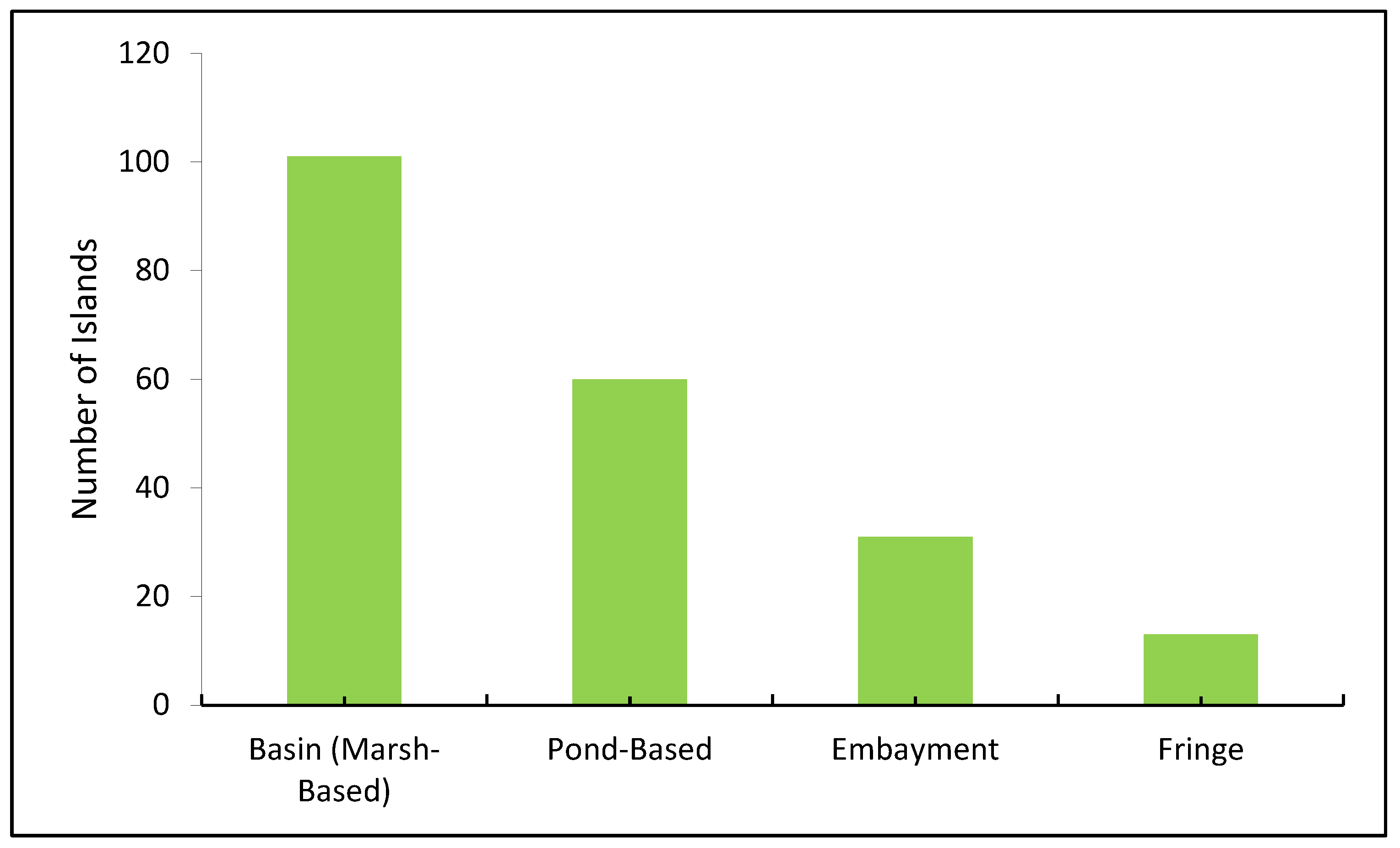
3.1. Distribution of Mangrove in the Maldives

This study presents the first verified and comprehensive assessment of mangrove distribution across all 20 administrative atolls of the Maldives. A total of 162 islands were identified with mangrove presence, representing a 50% increase compared to the 108 islands previously documented [28]. This substantial improvement reflects more comprehensive field coverage, particularly in remote and uninhabited islands. Earlier national estimates of mangrove presence identified 150 islands [27], while subsequent government assessments in 2015 reported only 75 mangrove or wetland islands [29]. These discrepancies likely reflect both actual habitat loss and methodological limitations, particularly limited field verification in remote or uninhabited islands. The present study achieves approximately 85% coverage of known suitable islands, improving confidence in national mangrove estimates. The present findings confirm that mangrove distribution is highly variable across atolls. Shaviyani Atoll hosts the highest number of mangrove-bearing islands (22), followed by Haa Dhaalu Atoll with 21 islands. Other atolls with significant mangrove occurrence include Haa Alifu, Noonu, and Huvadhoo, each with 15 or more islands supporting mangrove vegetation. To visualize the national spatial pattern, Figure 2 presents a map of all islands with confirmed mangrove presence across the archipelago. The colored points represent islands where mangroves were documented based on field verification, literature review, and secondary datasets. The map highlights the higher density of mangrove-bearing islands in the northern and southern regions and the relative sparsity in the central atolls.
While northern and southern atolls host a higher number of mangrove-bearing islands, differences in species diversity and community structure across these regions are further explored in Section 3.2. Figure 3 presents a shade plot illustrating the presence and abundance of mangrove species by atoll. This visualization highlights the variation in species composition across the country, revealing both diverse and mono-specific islands. In contrast, several central atolls, such as Vaavu, Faafu, and Thaa, exhibited sparse mangrove presence, both in terms of the number of islands and overall area. These atolls typically support only one or two mangrove stands, often fragmented and isolated. Five atolls, namely Ari, Vaavu, Faafu, Dhaalu, and Thaa, were recorded as mono-specific, with mangrove presence confined to a single island or patch, underscoring their ecological vulnerability and limited mangrove coverage. These areas are particularly susceptible to local extinction events and should be prioritized for restoration. A broad spatial pattern is evident, with northern and southern atolls generally exhibiting greater mangrove representation, while central atolls tend to be more depauperate. The observed gradient in mangrove diversity and distribution, from more diverse northern and southern atolls to depauperate central ones, may be influenced by underlying geomorphological differences, variations in freshwater input, and differential exposure to disturbance regimes [28,30]. Notably, the 2020 extreme Indian Ocean Dipole (IOD) event is known to have triggered widespread mangrove dieback in several parts of the country, potentially contributing to current patterns of distribution and species richness [25,26]. To support local-scale planning and conservation, Figure 4 presents individual maps of all 20 atolls with confirmed mangrove presence. These maps illustrate the intra-atoll distribution of mangrove-bearing islands, providing a detailed spatial reference for island-specific restoration and ecosystem-based management.

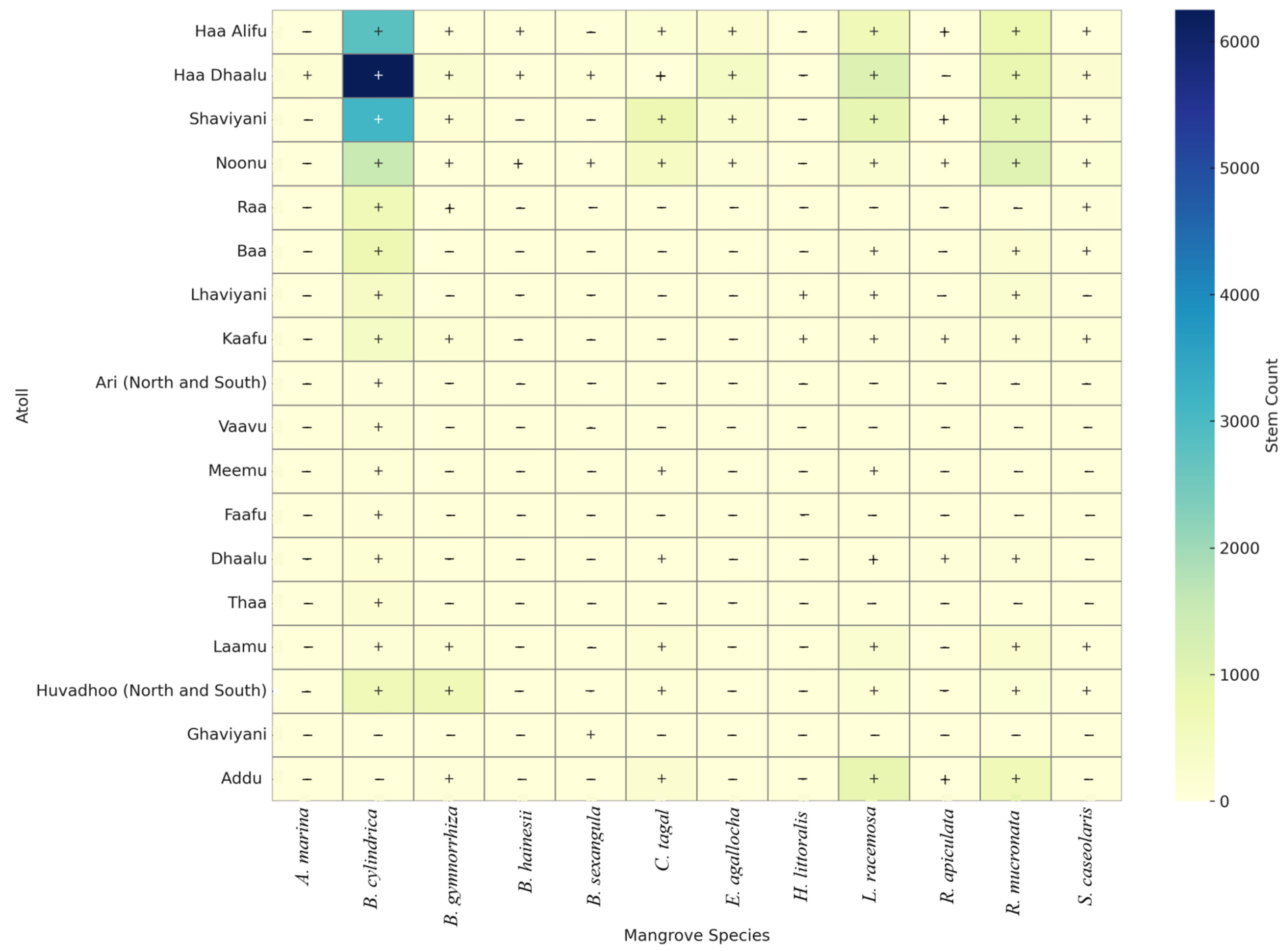
3.2. Atoll-Wise Mangrove Diversity Pattern

The analysis of mangrove diversity across the Maldivian atolls using key ecological indices reveals pronounced spatial heterogeneity (Table 1). The Shannon Diversity Index (H’), a measure of species abundance and distribution, ranged from 0.00 in Ari, Vaavu, Faafu, Thaa, and Gnaviyani Atolls to a maximum of 1.5447 in Laamu Atoll. This wide range suggests a monoculture of mangrove species to moderately diverse ecosystems. Correspondingly, the Simpson Dominance Index varied from 0.2309 (Laamu) to 1.0000 (in atolls with no recorded diversity), indicating the degree to which a few species dominate a community. Lower values signify a more even dominance among species. Laamu Atoll’s low dominance score reinforces its high diversity status, reflecting a well-balanced mangrove ecosystem. Pielou’s evenness index (J’), which assesses the uniformity of species distribution, revealed that several atolls maintain a relatively equitable composition of mangrove species. Notably, Dhaalu (0.8775), Laamu (0.8621), Meemu (0.7836), Addu (0.7462), and Shaviyani (0.7294) exhibited high evenness, suggesting the absence of dominance by a single species and a stable community structure where diversity exists. Margalef’s richness index (d), indicating species richness relative to total individuals, was highest in Noonu (0.9815), Kaafu (0.9074), Haa Dhaalu (0.8762) and Haa Alifu (0.8309). These values suggest that northern atolls tend to support more diverse mangrove flora in terms of species count. Overall, Laamu Atoll emerged as the most ecologically robust mangrove site, combining the highest diversity, high evenness, and low dominance. Noonu, Shaviyani, and Kaafu Atoll also demonstrated favorable diversity patterns, likely due to conducive geomorphological conditions or effective conservation.
In contrast, Ari, Vaavu, Faafu, Thaa, and Gnaviyani recorded zero scores across most indices, implying a near absence of mangrove habitats. These areas may require focused restoration efforts, possibly due to past anthropogenic pressures or unsuitable environmental conditions. Interestingly, Raa Atoll, though not devoid of mangroves, showed high dominance (0.9157) and low evenness (0.2609), indicating ecological imbalance and potential vulnerability to disturbance due to the dominance of a limited number of species. Based on the integrated ranking derived from four key ecological indices (Shannon diversity, Pielou’s evenness, Margalef’s richness, and Simpson dominance), nine atolls emerged as the most mangrove-rich and ecologically balanced regions in the Maldives. These include Laamu, Noonu, Shaviyani, Dhaalu, Kaafu, Huvadhoo, Haa Alifu, Haa Dhaalu, and Addu Atoll.
To further assess whether mangrove diversity differs across broader geographic regions of the Maldives, atolls were grouped into three zones: northern (N), central (C), and southern (S). Table 1 summarizes the mean diversity values (± SD) by region and presents the results of Kruskal–Wallis tests conducted on each index. The analysis revealed no statistically significant regional differences in Margalef’s richness (p = 0.141), Shannon diversity (p = 0.324), or Simpson dominance (p = 0.367), indicating that overall species richness and diversity were relatively comparable where mangroves occurred. However, Pielou’s evenness index differed significantly between regions (p = 0.040), suggesting that the uniformity of species distribution varies across zones. This finding supports earlier observations of mono-specific or dominance-prone stands in central atolls and highlights the greater community balance in northern and southern zones. Collectively, these atolls consistently demonstrated high species diversity, evenness in distribution, and relatively low dominance by individual species. This multi-metric performance underscores their ecological resilience and significance. As such, these regions represent critical conservation zones and should be prioritized for biodiversity monitoring, adaptive management, and the enhancement of ecosystem services, such as coastal protection, carbon sequestration, and nursery habitats for marine fauna.

3.3. Species-Level Mangrove Diversity Pattern

The Maldives is recognized for its high mangrove species diversity within the Indian Ocean region, with 15 of the 17 regional species reported from the archipelago [31]. However, inconsistencies persist in species composition across various surveys. Earlier assessments by [32] and [27] reported 12–13 species, while [31] recorded 15. A more recent synthesis by [28] identified 14 species. These discrepancies likely reflect differences in field coverage, species misidentification, and classification criteria used across studies. In this study, we confirmed the presence of 12 true mangrove species (Table 2), based on systematic field surveys conducted across 162 islands. We excluded Pemphis acidula (locally called Kuredhi), although listed as a true mangrove by [7], due to its ubiquitous presence on island coastlines in Maldives irrespective of mangrove habitats, in alignment with [33]. Xylocarpus moluccensis was also excluded, as field evidence indicated the presence of Xylocarpus rumphii, a coastal forest species not typically associated with true mangrove environments [28,34]. Two additional taxa (Acrostichum aureum and Derris heterophylla) were classified as mangrove associates, following the framework proposed by [28,35,36,37]. Analysis of species-level diversity indices revealed marked interspecific variation in abundance, richness, and evenness (Table 3). B. cylindrica emerged as the most widespread and abundant species, present across 16 atolls. It also recorded high values in Shannon diversity (H′ = 2.77), Simpson diversity (1 − λ = 0.79), and Margalef richness (d = 1.54), underscoring its ecological dominance. However, its Pielou evenness (J′ = 0.69) suggested moderate imbalance in abundance across sites.
R. mucronata exhibited the highest Shannon diversity (H′ = 2.99) and a high Simpson index (1 − λ = 0.85), reflecting both widespread distribution and balanced relative abundance. L. racemosa followed closely with H′ = 2.64, reinforcing its role as a structural and floristic contributor to diverse mangrove assemblages in the country. Rhizophora apiculata, although recorded in only three atolls, exhibited relatively high evenness (J′ = 0.92) and moderate diversity values (H′ = 1.46; 1 − λ = 0.62). This indicates that while it was less widespread, it maintained a stable presence where it occurred, often co-dominating with other R. mucronata in tidal bay systems. Avicennia marina, a widely distributed species in many Indo-Pacific mangrove systems, was surprisingly rare in the Maldives, found in only one atoll (Haa Dhaalu Atoll). This may be attributed to its ecological preference for hypersaline conditions, which are less common across the Maldivian atolls. Its diversity values were negligible (H′ = 0.0; 1 − λ = 0.0), suggesting that it plays a minimal ecological role in Maldivian mangrove forests. Huvadhoo Atoll supported the highest concentration of B. gymnorrhiza, particularly within marsh and pond-based ecosystems. In some islands of Huvadhoo, B. gymnorrhiza formed extensive stands and was often the primary species, underscoring its regional abundance and importance.
C. tagal was moderately represented across the Maldives, occurring in eight atolls and frequently coexisting with dominant species such as B. cylindrica and R. mucronata. Although it did not dominate in most sites, it was notably the dominant species on Farukolhu Island in Shaviyani Atoll, where it forms well-developed stands in embayment habitats. Overall, the species exhibited relatively high diversity values (H′ = 2.23; 1 − λ = 0.73) and good evenness (J′ = 0.74), indicating a stable and balanced presence within multispecies communities. C. tagal was most commonly observed in bay and embayment systems, particularly in Shaviyani, Noonu, and Laamu Atolls, often occupying slightly elevated intertidal zones. While not abundant throughout the archipelago, C. tagal contributes meaningfully to the diversity and structure of mangrove forests where it occurs. Sonneratia caseolaris was recorded in nine atolls and contributed moderately to species-level diversity across the Maldives. Maavaidhoo island in Shaviyani Atoll was noted in this study for its large S. caseolaris trees. Although not dominant in any location, it displayed relatively high diversity indices (H′ = 2.38; 1 − λ = 0.77) and good evenness (J′ = 0.75), indicating a well-balanced presence within mixed-species mangrove stands. Its widespread yet modest abundance suggests a supporting ecological role, particularly in wetter, low-energy mangrove habitats. Conversely, several species displayed low abundance and restricted occurrence. B. hainesii, a globally vulnerable species (IUCN Red List), was recorded in only two locations with five individuals, yielding low diversity indices (H′ = 0.72; 1 − λ = 0.40), signaling its conservation urgency. Similarly, H. littoralis and Bruguiera sexangula exhibited limited presence and contributed minimally to overall community structure. These findings highlight a dual pattern in Maldivian mangrove ecosystems: a few widespread and dominant species (B. cylindrica, R. mucronata, L. racemosa) forming the ecological backbone of most stands, and a suite of rare or locally confined species (B. hainesii, H. littoralis, B. sexangula, R. apiculata) that are ecologically and conservatively significant. The dominance of B. cylindrica in marsh-based systems likely reflects its adaptation to stagnant or seasonally inundated conditions with lower salinity and high organic matter. These traits confer competitive advantage in the flat, inland depressions typical of basin-type habitats. The integration of abundance-based indices with presence-absence data, thus, provides a robust basis for prioritizing both habitat-level and species-specific conservation interventions.

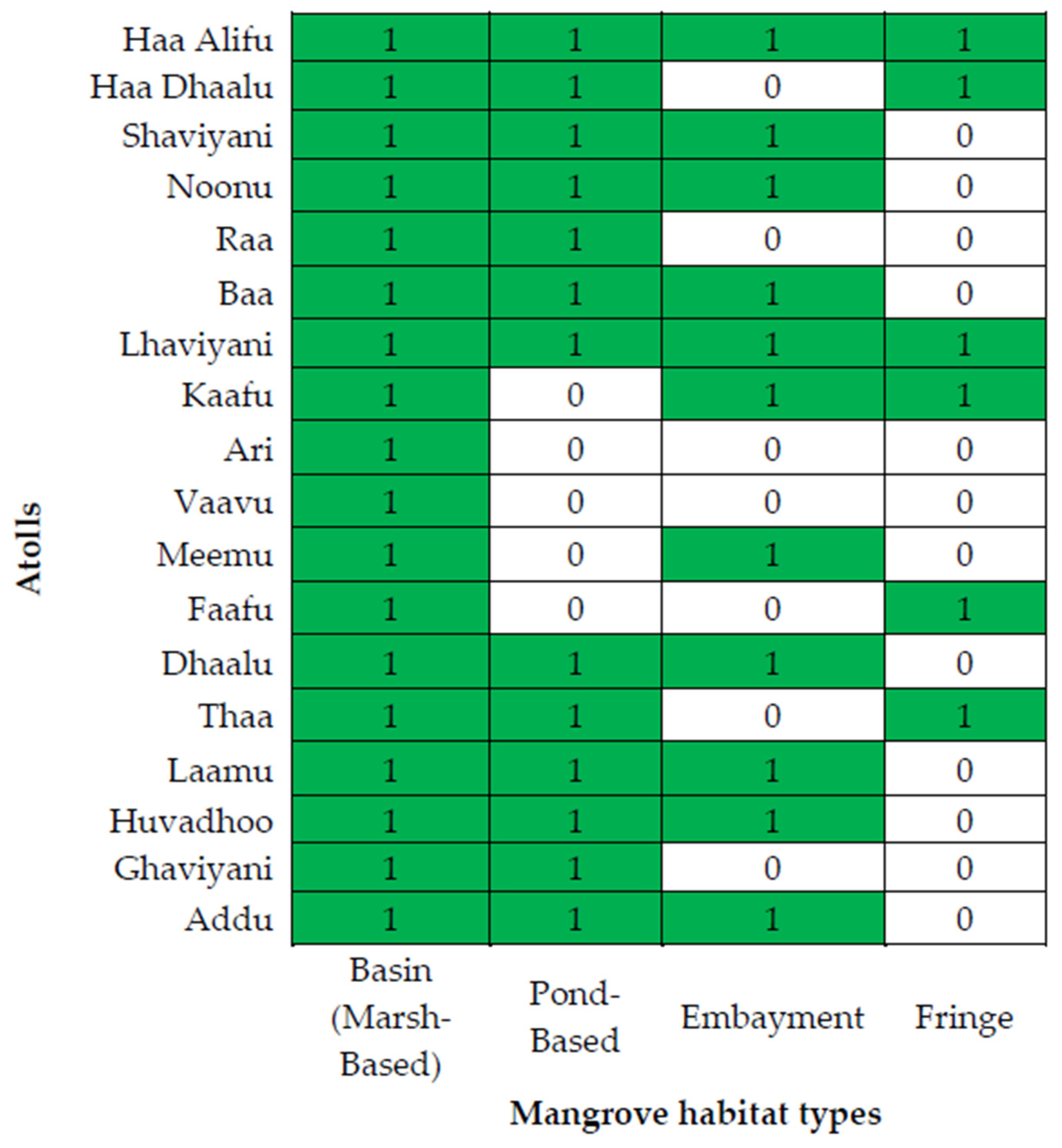
3.4. Mangrove Habitat Classification Across Atolls

Mangrove and wetland ecosystems in the Maldives are distributed both along coastal fringes and in inland depressions, some of which are hydrologically connected to the sea. These habitats frequently support mangrove vegetation. In local terminology, mangroves are commonly found in “chasbin” (muddy areas with little or no standing water) and “kulhi” (enclosed or semi-enclosed brackish water bodies). In this study, we adopted a classification framework aligned with both global and local typologies. Internationally, ref. [1] proposed six mangrove forest types based on morphology, productivity, and hydrological characteristics: riverine, overwash, fringe, basin, scrub, and hammock forests. Locally, ref. [27] categorized Maldivian mangroves into four primary types: pond-based (occur around enclosed or semi-enclosed water bodies), marsh-based (found inland without standing water bodies), fringing (narrow strips along the shoreline exposed to tidal influence), and embayment mangroves (sheltered coastal areas with direct sea openings). Our national assessment confirms that marsh-based mangroves are the most widespread, occurring on 101 islands. Pond-based systems were observed on 60 islands, followed by embayment mangroves on 31 islands and fringing systems on only 13 islands. These patterns highlight the ecological dominance of inland, basin-type mangrove formations across the Maldives and are visually summarized in Figure 5.
The classification also revealed clear spatial variation across the atolls. Northern and southern atolls generally supported all four habitat types, reflecting higher ecological diversity and geomorphological complexity. In contrast, central atolls were often limited to marsh and embayment systems, with few or no pond-based or fringing habitats. This geographic variation is illustrated in Figure 6, which maps the presence and absence of each habitat type across all 20 administrative atolls.

3.5. Patterns in Habitat–Species Relationships

Mangrove species in the Maldives display distinct spatial and ecological affinities to different habitat types. The classification of mangrove habitats into four geomorphological types (marsh-based, pond-based, embayment, and fringing system) enabled a clearer understanding of how species are distributed based on observable hydrological and landscape characteristics. Marsh-based mangroves, the most widespread habitat type identified on 97 islands, predominantly supported B. cylindrica, which emerged as the most frequently encountered species in these systems. B. cylindrica’s adaptability to both stagnant and seasonally inundated inland depressions, combined with its tolerance for lower salinity and organic-rich soils, explains its dominance in marsh habitats, particularly in northern atolls. These marsh systems, while floristically less diverse than embayment habitats, provide essential inland refugia for foundational species. In contrast, pond-based mangroves, recorded on 61 islands, supported higher structural complexity and often greater species co-occurrence. Notably, R. mucronata and B. gymnorrhiza were commonly associated with pond systems, particularly in Laamu and Huvadhoo atolls, where these species frequently co-dominated. Pond systems, typically semi-enclosed or enclosed water bodies with brackish conditions, offered more hydrological stability and tidal connectivity, which likely facilitated the growth of species with higher salt tolerance and stilt-root morphology.
Embayment mangroves, occurring on 29 islands, displayed the greatest floristic heterogeneity. These habitats, directly open to sea influence and subject to regular tidal flushing, supported the co-occurrence of C. tagal, R. apiculata, and L. racemose. C. tagal, in particular, was observed to dominate embayment systems on Farukolhu Island (Shaviyani Atoll), forming dense, monodominant patches. Its affinity to embayment environments aligns with its known ecological preference for elevated intertidal zones with moderate salinity and good drainage. Similarly, L. racemosa exhibited a broader tolerance for open, tidally active systems and was commonly recorded along embayed coasts in Laamu and Kaafu atolls. Fringing mangroves, the least common habitat type recorded on only 12 islands, were primarily associated with R. mucronata and occasionally B. cylindrica, especially in Addu and Haa Dhaalu Atolls. These linear, narrow systems occur along exposed coastal edges and are subject to high wave energy and frequent inundation. The dominance of R. mucronata in these environments is consistent with its structural adaptations, including robust stilt roots that stabilize it in dynamic, tidally active zones. S. caseolaris, typically associated with low-energy brackish environments, was occasionally observed in protected fringe settings where freshwater inputs or reduced salinity occurred. Species-habitat associations also showed that rare or less abundant species were often limited to specific habitat types. For instance, H. littoralis and B. hainesii were mostly restricted to isolated marsh and pond systems with relatively stable hydrology and limited tidal influence, reflecting their narrow ecological amplitude and possible vulnerability to habitat alteration. Overall, the findings illustrate that mangrove species in the Maldives are not randomly distributed but exhibit strong ecological filtering based on habitat type.
To statistically test these observed patterns, a two-factor PERMANOVA was conducted to assess whether mangrove species composition varied significantly with both dominant habitat type and geographic region (north, central, south). The analysis revealed a significant combined effect (F = 2.84, R2 = 0.378, p = 0.002), indicating that both spatial distribution and habitat structure jointly influence species composition across the archipelago. While this study did not include direct measurements of hydrological or sediment characteristics, previous research has documented environmental variation across the Maldivian archipelago that likely influences mangrove species composition and distribution. For example, geomorphological context and water chemistry have been shown to shape species assemblages across atolls [28]. Similarly, environmental gradients including differences in salinity regimes, freshwater input, and tidal amplitude can restrict the distribution of certain mangrove species to specific zones [30]. These findings support our observed patterns, where species such as A. marina B. hainesii and H. littoralis were confined to specific atolls, potentially reflecting environmental filtering. Future studies integrating these environmental variables are needed to confirm and model species–habitat relationships more precisely. This spatial partitioning reflects both environmental tolerances and species-specific ecological strategies. Recognizing these habitat–species linkages is essential for designing conservation strategies that preserve not just species richness but also the ecological conditions necessary for sustaining mangrove biodiversity. Management and restoration efforts must, therefore, consider habitat type as a key determinant of species occurrence, especially when targeting rare or functionally important species in degraded or fragmented landscapes.

3.6. Conservation Implications and Priority Areas

The findings of this study offer critical insights for the design of effective mangrove conservation and management strategies in the Maldives. The spatial heterogeneity observed in mangrove diversity, habitat types, and species assemblages across atolls underscores the need for location specific conservation planning rather than uniform, archipelago-wide approaches. The clear biogeographic gradient, whereby northern and southern atolls host more diverse and structurally complex mangrove communities while central atolls are floristically impoverished, suggests that both biodiversity hotspots and ecologically degraded areas should be prioritized, albeit for different objectives. Atolls such as Laamu, Noonu, and Shaviyani, which consistently scored high across all diversity indices, should be considered for targeted protection and biodiversity monitoring. Their ecological richness makes them strong candidates for designation under national or regional conservation frameworks. Many of these sites support multiple habitat types (e.g., pond and embayment systems) and harbor both common and rare species. They should be prioritized for strict protection and ongoing ecological monitoring. In particular, areas where rare species such as B. hainesii, H. littoralis, and R. apiculata were recorded, often in specific marsh or pond environments, require urgent site-based conservation attention due to their limited distributions and vulnerability to habitat alteration. Conversely, mono-specific or degraded systems in central atolls such as Ari, Faafu, and Thaa, though low in species richness, present opportunities for restoration and species enrichment. These areas, typically dominated by B. cylindrica, can be strategically targeted for replanting efforts to reintroduce native diversity and restore structural complexity. Restoration planning should be informed based on local hydrology and geomorphological suitability to ensure the survival and functional integration of introduced species.
Habitat classification also provides a practical framework for conservation prioritization. For example, embayment and pond-based mangroves, which support higher species co-occurrence and host regionally important taxa like C. tagal and L. racemosa, may be more vulnerable to salinity changes, reclamation, or tourism-driven coastal development. These systems should be formally recognized as high-value ecological zones within environmental impact assessments (EIAs) and land use planning instruments. At the policy level, this study supports the expansion of the national Environmentally Sensitive Areas (ESA) List to include underrepresented islands and habitats identified here. Additionally, the long-term protection of mangrove-rich islands, especially those currently unprotected but ecologically significant, should be pursued through legal designation under the Protected and Conserved Areas Framework. The integration of citizen science, community co-management, and climate resilience indicators into future monitoring frameworks will further strengthen the protection of mangrove ecosystems in the Maldives. Future integration of satellite-based remote sensing, coupled with machine learning approaches, could enable the predictive modelling of mangrove dynamics under different climate change scenarios. These tools would support near-real-time monitoring and inform adaptive management strategies across the archipelago.

4. Conclusions

This study represents the first verified and island-level assessment of mangrove diversity, distribution, and habitat structure across the Maldives. The results demonstrate significant spatial variability in species richness and ecological balance, with northern and southern atolls supporting more diverse and resilient mangrove communities compared to central atolls. Habitat–species relationships were consistent with known ecological tolerances, affirming the importance of hydrological and geomorphological conditions in structuring mangrove assemblages.
The classification of mangrove habitats into marsh, pond, embayment, and fringing systems offers a practical tool for localized conservation planning. This work provides a national baseline for biodiversity monitoring and supports the development of habitat-specific management strategies, especially for rare or threatened species such as B. hainesii.
While this study provides a robust floristic and habitat-based baseline for mangrove diversity in the Maldives, it did not include analysis of structural forest parameters such as tree diameter or canopy height due to logistical limitations and the broad geographic coverage of the survey. Future research should build upon this dataset by incorporating detailed structural assessments at the site level, particularly in ecologically intact or degraded areas, to better understand forest maturity, carbon storage, and regeneration dynamics. Such studies would complement the present findings and strengthen long-term conservation and restoration planning to enhance the adaptive resilience of Maldivian mangrove systems.

Supplementary Materials

The following supporting information is available online at https://www.mdpi.com/article/10.3390/earth6030066/s1, Table S1: List of mangrove islands in the Maldives.

Author Contributions

Conceptualization, A.A.F. and S.B.N.; methodology, A.A.F., S.S. and R.N.; software, A.A.F., N.R.H. and R.N.; validation, A.A.F., S.B.N., S.S., M.R., N.R.H. and I.N.; formal analysis, R.N., A.A.F., I.N. and N.R.H.; investigation, M.R., A.A.F. and S.S.; data curation, A.A.F., R.N., and M.R.; writing—original draft preparation, A.A.F.; writing—review and editing, A.A.F., R.N., S.S.; visualization, S.B.N., A.A.F., N.R.H. and I.N.; supervision, S.B.N.; project administration, A.A.F. All authors have read and agreed to the published version of the manuscript.

Funding

This research received no external funding.

Data Availability Statement

Data are contained within the article or Supplementary Material. The original contributions presented in this study are included in the article/Supplementary Material. Further inquiries can be directed to the corresponding author(s).

Acknowledgments

We gratefully acknowledge the Atoll and Island Councils across the Maldives for their support during fieldwork, and the Environmental Protection Agency (EPA) for their technical guidance. Special thanks to the field volunteers for their valuable assistance, and to the Maldives Wetlands Foundation for logistical support. We would also like to thank Ibrahim Mohamed and Mohamed Zahir for their expert input and contributions to species identification and contextual interpretation during the study. The corresponding author also acknowledges the Indian Council for Cultural Relations (ICCR) for providing the PhD scholarship under which this research was undertaken. The authors take full responsibility for the content of this publication.

Conflicts of Interest

The authors declare no conflicts of interest.

References

  1. Lugo, A.E.; Snedaker, S.C. The Ecology of Mangroves. Annu. Rev. Ecol. Syst. 1974, 5, 39–64. [Google Scholar] [CrossRef]
  2. Choudhary, B.; Dhar, V.; Pawase, A.S. Blue carbon and the role of mangroves in carbon sequestration: Its mechanisms, estimation, human impacts and conservation strategies for economic incentives. J. Sea Res. 2024, 199, 102504. [Google Scholar] [CrossRef]
  3. Biswas, P.L.; Biswas, S.R. Mangrove Forests: Ecology, Management, and Threats. In Life on Land; Springer: Berlin/Heidelberg, Germany, 2021; pp. 627–640. [Google Scholar]
  4. Sreelekshmi, S.; Preethy, C.M.; Varghese, R.; Joseph, P.; Asha, C.V.; Bijoy Nandan, S.; Radhakrishnan, C.K. Diversity, stand structure, and zonation pattern of mangroves in southwest coast of India. J. Asia-Pac. Biodivers. 2018, 11, 573–582. [Google Scholar] [CrossRef]
  5. Kathiresan, K.; Bingham, B.L. Biology of mangroves and mangrove Ecosystems. Adv. Mar. Biol. 2001, 40, 81–251. [Google Scholar] [CrossRef]
  6. Kumar, A.; Anju, T.; Archa, V.; Warrier, V.P.; Kumar, S.; Goud, G.S.; Kashyap, A.K.; Singh, S.; Komal Singh, P.; Kumar, R.; et al. Mangrove Forests. In Wetlands Conservation; Wiley: Hoboken, NJ, USA, 2021; pp. 229–271. [Google Scholar]
  7. Mark, S.; Mami, K.; Collins, L. World Atlas of Mangroves; Routledge: London, UK, 2010. [Google Scholar]
  8. Friess, D.A.; Rogers, K.; Lovelock, C.E.; Krauss, K.W.; Hamilton, S.E.; Lee, S.Y.; Lucas, R.; Primavera, J.; Rajkaran, A.; Shi, S. The State of the World’s Mangrove Forests: Past, Present, and Future. Annu. Rev. Environ. Resour. 2019, 44, 89–115. [Google Scholar] [CrossRef]
  9. Tomlinson, P.B. The Botany of Mangroves, 2nd ed.; Cambridge University Press: Cambridge, UK, 2016. [Google Scholar]
  10. Sahana, M.; Areendran, G.; Sajjad, H. Assessment of suitable habitat of mangrove species for prioritizing restoration in coastal ecosystem of Sundarban Biosphere Reserve, India. Sci. Rep. 2022, 12, 20997. [Google Scholar] [CrossRef] [PubMed]
  11. Romañach, S.S.; DeAngelis, D.L.; Koh, H.L.; Li, Y.; Teh, S.Y.; Raja Barizan, R.S.; Zhai, L. Conservation and restoration of mangroves: Global status, perspectives, and prognosis. Ocean Coast. Manag. 2018, 154, 72–82. [Google Scholar] [CrossRef]
  12. Barbier, E.B.; Hacker, S.D.; Kennedy, C.; Koch, E.W.; Stier, A.C.; Silliman, B.R. The value of estuarine and coastal ecosystem services. Ecol. Monogr. 2011, 81, 169–193. [Google Scholar] [CrossRef]
  13. Arceo-Carranza, D.; Chiappa-Carrara, X.; Chávez López, R.; Yáñez Arenas, C. Mangroves as Feeding and Breeding Grounds. In Mangroves: Ecology, Biodiversity and Management; Springer: Singapore, 2021; pp. 63–95. [Google Scholar]
  14. Alongi, D.M. Global Significance of Mangrove Blue Carbon in Climate Change Mitigation. Science 2020, 2, 67. [Google Scholar] [CrossRef]
  15. Carugati, L.; Gatto, B.; Rastelli, E.; Lo Martire, M.; Coral, C.; Greco, S.; Danovaro, R. Impact of mangrove forests degradation on biodiversity and ecosystem functioning. Sci. Rep. 2018, 8, 13298. [Google Scholar] [CrossRef]
  16. Lukman, K.M.; Quevedo, J.M.D.; Rifai, H.; Alifatri, L.O.; Ulumuddin, Y.I.; Sofue, Y.; Uchiyama, Y.; Kohsaka, R. Mangrove forest food products as alternative livelihood measures: Mangrove conservation by community in Muara Gembong, Bekasi Regency, Indonesia. Discov. Sustain. 2025, 6, 237. [Google Scholar] [CrossRef]
  17. Bunting, P.; Rosenqvist, A.; Hilarides, L.; Lucas, R.M.; Thomas, N.; Tadono, T.; Worthington, T.A.; Spalding, M.; Murray, N.J.; Rebelo, L.-M. Global Mangrove Extent Change 1996–2020: Global Mangrove Watch Version 3.0. Remote Sens. 2022, 14, 3657. [Google Scholar] [CrossRef]
  18. Wang, Y.-S.; Gu, J.-D. Ecological responses, adaptation and mechanisms of mangrove wetland ecosystem to global climate change and anthropogenic activities. Int. Biodeterior. Biodegrad. 2021, 162, 105248. [Google Scholar] [CrossRef]
  19. Duke, N.C. Mangrove Floristics and Biogeography Revisited: Further Deductions from Biodiversity Hot Spots, Ancestral Discontinuities, and Common Evolutionary Processes. In Mangrove Ecosystems: A Global Biogeographic Perspective; Springer International Publishing: Cham, Germany, 2017; pp. 17–53. [Google Scholar]
  20. Wang, B.S.; Liang, S.C.; Zhang, W.Y.; Zan, Q. Mangrove Flora of the world. Acta Bot. Sin. 2003, 45, 644–653. [Google Scholar]
  21. Kanniah, K.D.; Kang, C.S.; Sharma, S.; Amir, A.A. Remote Sensing to Study Mangrove Fragmentation and Its Impacts on Leaf Area Index and Gross Primary Productivity in the South of Peninsular Malaysia. Remote Sens. 2021, 13, 1427. [Google Scholar] [CrossRef]
  22. Lee, S.Y.; Primavera, J.H.; Dahdouh-Guebas, F.; McKee, K.; Bosire, J.O.; Cannicci, S.; Diele, K.; Fromard, F.; Koedam, N.; Marchand, C.; et al. Ecological role and services of tropical mangrove ecosystems: A reassessment. Glob. Ecol. Biogeogr. 2014, 23, 726–743. [Google Scholar] [CrossRef]
  23. Curnick, D.J.; Pettorelli, N.; Amir, A.A.; Balke, T.; Barbier, E.B.; Crooks, S.; Dahdouh-Guebas, F.; Duncan, C.; Endsor, C.; Friess, D.A.; et al. The value of small mangrove patches. Science 2019, 363, 239. [Google Scholar] [CrossRef]
  24. Ruslan, N.F.N.; Goh, H.C.; Hattam, C.; Edwards-Jones, A.; Moh, H.H. Mangrove ecosystem services: Contribution to the well-being of the coastal communities in Klang Islands. Mar. Policy 2022, 144, 105222. [Google Scholar] [CrossRef]
  25. Carruthers, L.; Ersek, V.; Maher, D.; Sanders, C.; Tait, D.; Soares, J.; Floyd, M.; Hashim, A.S.; Helber, S.; Garnett, M.; et al. Sea-level rise and extreme Indian Ocean Dipole explain mangrove dieback in the Maldives. Sci. Rep. 2024, 14, 27012. [Google Scholar] [CrossRef]
  26. Sreelekshmi, S.; Aneesh, B.; Nandan, S.B.; Ali, A.F.; Hussain, M.S.; Smart, K.B.; Praved, P.H.; Harikrishnan, M.; Gopinath, G.; Achu, A.; et al. Distribution, drivers, and community perceptions of recent mass mangrove dieback in Maldives. Reg. Environ. Change 2025, 25, 48. [Google Scholar] [CrossRef]
  27. Saleem, A.; Nileysha, A. Characteristics, status and need for conservation of mangrove ecosystems in the republic of Maldives, Indian ocean. J. Natl. Sci. Found. Sri Lanka 2023, 31, 201. [Google Scholar] [CrossRef]
  28. Cerri, F.; Louis, Y.D.; Fallati, L.; Siena, F.; Mazumdar, A.; Nicolai, R.; Zitouni, M.S.; Adam, A.S.; Mohamed, S.; Lavorano, S.; et al. Mangroves of the Maldives: A review of their distribution, diversity, ecological importance and biodiversity of associated flora and fauna. Aquat. Sci. 2024, 86, 44. [Google Scholar] [CrossRef]
  29. Ministry of Environment and Energy. Fifth National Report of Maldives to the Convention on Biological Diversity; Ministry of Environment and Energy: Malé, Maldives, 2015. [Google Scholar]
  30. Shazra, A.; Rasheed, S.; Ansari, A.A. Study on the Mangrove Ecosystem in Maldives. Glob. J. Environ. Res. 2008, 2, 84–86. [Google Scholar]
  31. Sivakumar, K.; Rilwan, A.; Priyanka, K.; Salah, M.; Kathiresan, K. An electronic journal dedicated to enhance public awareness on the importance of mangrove ecosystems Mangroves of the atolls of the Maldives, rich among the atoll groups of the Indian Ocean. ISME/GLOMIS Electron. J. 2018, 16, 11–18. [Google Scholar]
  32. Jagtap, T.G.; Untawale, A.G. Atoll mangroves and associated flora from Republic of Maldives, Indian Ocean. Int. Soc. Mangrove Ecosyst. 1999, 5, 17. [Google Scholar]
  33. Selvam, V. Trees and Shrubs of the Maldives, 1st ed.; FAO Regional Office for Asia and the Pacific: Bangkok, Thailand, 2007. [Google Scholar]
  34. Guo, Z.; Guo, W.; Wu, H.; Fang, X.; Ng, W.L.; Shi, X.; Liu, Y.; Huang, Z.; Li, W.; Gan, L.; et al. Differing phylogeographic patterns within the Indo-West Pacific mangrove genus Xylocarpus (Meliaceae). J. Biogeogr. 2018, 45, 676–689. [Google Scholar] [CrossRef]
  35. Das, A.; Parida, A.; Basak, U.; Das, P. Studies on pigments, proteins and photosynthetic rates in some mangroves and mangrove associates from Bhitarkanika, Orissa. Mar. Biol. 2002, 141, 415–422. [Google Scholar] [CrossRef]
  36. Wang, L.; Mu, M.; Li, X.; Lin, P.; Wang, W. Differentiation between true mangroves and mangrove associates based on leaf traits and salt contents. J. Plant Ecol. 2011, 4, 292–301. [Google Scholar] [CrossRef]
  37. Mukherjee, A.K.; Acharya, L.; Panda, P.C.; Mohapatra, T. Assessment of Genetic Diversity in 31 Species of Mangroves and their Associates through RAPD and AFLP Markers. Z. Für Naturforsch C 2006, 61, 413–420. [Google Scholar] [CrossRef]
Figure 1. Map showing the geographic location of the Maldives in the Indian Ocean and the distribution of the 20 administrative atolls included in this study. The inset highlights the national context relative to South Asia, with individual atolls labeled to reflect the scope of field surveys. For regional analysis, atolls were categorized into three geographic zones: northern (N) atolls (Haa Alif to Lhaviyani), central (C) atolls (Kaafu to Laamu), and southern (S) atolls (Gaafu Alif to Seenu/Addu).
Earth 06 00066 g001
Figure 2. Distribution of islands with a reported presence of mangroves (points with the same color are islands belonging to the same atoll) in the Maldives according to our review of the literature and field observations (produced with Esri, DigitalGlobe, GeoEye, i-cubed, USDA FSA, USGS, AEX, Getmapping, Aerogrid, IGN, IGP, swisstopo, and the GIS User Community).
Earth 06 00066 g002
Figure 3. Shadeplot showing mangrove species presence (+), absence (−), and abundance (color intensity) across 20 Maldivian atolls.
Earth 06 00066 g003
Figure 4. Atoll-level maps showing islands with confirmed mangrove presence across 20 Maldivian atolls (produced with Esri, DigitalGlobe, GeoEye, i-cubed, USDA FSA, USGS, AEX, Getmapping, Aerogrid, IGN, IGP, swisstopo, and the GIS User Community).
Earth 06 00066 g004aEarth 06 00066 g004bEarth 06 00066 g004c
Figure 5. Classification of mangrove habitat across all atolls.
Earth 06 00066 g005
Figure 6. Presence (green) and absence (white) of mangrove habitat types across Maldivian atolls. Habitat types include basin (marsh-based), pond-based, embayment, and fringing systems. Data illustrate the spatial variability in habitat composition and ecological complexity.
Earth 06 00066 g006
Table 1. Diversity patterns of mangrove communities across 20 surveyed atolls of the Maldives and regional comparison for the northern (N), central (C), and southern (S) atoll zones.
AtollS 1d′ 2H′ 3J′ 4λ′ 5
Haa Alifu90.83091.15450.5550.4257
Haa Dhaalu100.87621.13780.5180.485
Shaviyani80.68791.41930.7290.3206
Noonu100.98151.44590.6580.2998
Raa30.15330.18080.2610.9157
Baa40.43750.6350.4580.6583
Lhaviyani40.46740.78260.5650.5144
Kaafu70.90741.3410.6890.365
Ari100-1
Vaavu100-1
Meemu30.46320.86090.7840.5022
Faafu100-1
Dhaalu40.53951.21640.8780.3284
Thaa100-1
Laamu60.75811.54470.8620.2309
Huvadhoo50.67461.28280.7160.3341
Ghaviyani100-1
Addu50.40161.03440.7460.4003
Kruskal-Wallis Regional comparison *
N 0.63 ± 0.290.97 ± 0.460.53 ± 0.150.52 ± 0.21
C 0.27 ± 0.370.49 ± 0.630.78 ± 0.090.74 ± 0.33
S 0.36 ± 0.340.77 ± 0.680.73 ± 0.020.58 ± 0.37
p-value p = 0.141p = 0.324p = 0.040p = 0.367
1 S, number of species, 2 d′, Margalef’s species richness index, 3 H′, Shannon diversity index, 4 J′ Pielou’s evenness index, and 5 λ′, Simpson dominance index. * Values are presented as mean ± standard deviation.
Table 2. Identification of mangrove species of the Maldives and their IUCN list status.
Scientific NameFamilyCommon NameLocal Name (Dhivehi)IUCN Red List Category
A. marinaAcanthaceaeGrey mangroveBaruLC 1
B. cylindricaRhizophoraceaeSmall-leafed orange mangroveKan’dooLC
B. gymnorrhizaRhizophoraceaeOriental mangrove or large-leafed mangroveBodukandoo or BodavakiLC
B. hainesiiRhizophoraceaeEye of the crocodileKelavaki, or bodukandoo or maakandooCR 2
B. sexangulaRhizophoraceaeUpriver orange mangroveBodavakiLC
C. tagalRhizophoraceaeYellow mangroveKaramanaLC
E. agallochaEuphorbiaceaeBlind-your eye mangrove or milky mangroveThelaLC
H. littoralisMalvaceaeLooking-glass mangroveKaharuvahLC
L. racemosaCombretaceaeBlack mangroveBureviLC
R. apiculataRhizophoraceaeTall-stilt mangroveThakafathiLC
R. mucronataRhizophoraceaeRed mangroveRan’dooLC
S. caseolarisLythraceaeMangrove appleKuhlhavahLC
1 LC least concern, 2 CR critically endangered.
Table 3. Diversity pattern of mangrove species in Maldives.
SdJ′H′(log2)1 − λ′
A. marina10 00
B. cylindrica161.539470.6920122.7680490.791688
B. gymnorrhiza80.980330.6977652.0932950.664543
B. hainesii20.6213350.7219280.7219280.4
B. sexangula30.4342940.8649741.3709510.565657
C. tagal80.9388570.7438742.2316210.725469
Excoecaria agallocha40.4396010.8955451.7910890.676066
H. littoralis20.9102390.9182960.9182960.666667
L. racemosa111.199940.7621192.63650.808771
R. apiculata30.4526070.9193231.4570930.620041
R. mucronata111.1679290.8661332.996330.853686
S. caseolaris91.2811960.7521362.3842140.76659
S, number of species; d′, Margalef’s species richness index; H′, Shannon diversity index (calculated using log base 2); J′, Pielou’s evenness index; 1 − λ′, Inverse Simpson’s index.
Disclaimer/Publisher’s Note: The statements, opinions and data contained in all publications are solely those of the individual author(s) and contributor(s) and not of MDPI and/or the editor(s). MDPI and/or the editor(s) disclaim responsibility for any injury to people or property resulting from any ideas, methods, instructions or products referred to in the content.

