
Drought Periods Identification in Ecuador between 2001 and 2018 Using SPEI and MODIS Data †

 ,
, 
 and
and
Abstract
:1. Introduction
2. Materials and Methods
2.1. Study Region
2.2. Data Source and Processing
Meteorological and MODIS Data
2.3. Research Methods
2.3.1. Calculation of the SPEI
2.3.2. Calculation of the NDWI
2.4. Methodology
2.4.1. Runs Theory
2.4.2. NDWI Images
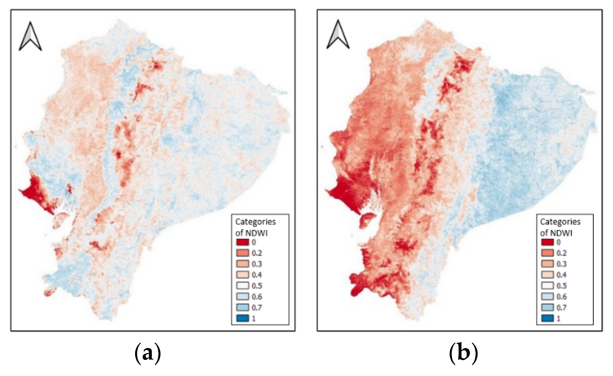
3. Results
4. Discussion and Conclusions
Author Contributions
Funding
Data Availability Statement
Acknowledgments
Conflicts of Interest
References
- Van Loon, A.F.; Laaha, G. Hydrological drought severity explained by climate and catchment characteristics. J. Hydrol. 2015, 526, 3–14. [Google Scholar] [CrossRef] [Green Version]
- West, H.; Quinn, N.; Horswell, M. Remote sensing for drought monitoring & impact assessment: Progress, past challenges and future opportunities. Remote Sens. Environ. 2019, 232, 111291. [Google Scholar] [CrossRef]
- Wilhite, D.A.; Glantz, M.H. Understanding: The Drought Phenomenon: The Role of Definitions. Water Int. 1985, 10, 111–120. [Google Scholar] [CrossRef] [Green Version]
- Du, L.; Tian, Q.; Yu, T.; Meng, Q.; Jancso, T.; Udvardy, P.; Huang, Y. A comprehensive drought monitoring method integrating MODIS and TRMM data. Int. J. Appl. Earth Obs. Geoinf. 2013, 23, 245–253. [Google Scholar] [CrossRef]
- Vicente-Serrano, S.M.; Beguería, S.; López-Moreno, J.I. A multiscalar drought index sensitive to global warming: The standardized precipitation evapotranspiration index. J. Clim. 2010, 23, 1696–1718. [Google Scholar] [CrossRef] [Green Version]
- Gao, B. NDWI—A Normalized Difference Water Index for Remote Sensing of Vegetation Liquid Water From Space. Remote Sens. Environ. 1996, 58, 257–266. [Google Scholar] [CrossRef]
- Xie, F.; Fan, H. Deriving drought indices from MODIS vegetation indices (NDVI/EVI) and Land Surface Temperature (LST): Is data reconstruction necessary? Int. J. Appl. Earth Obs. Geoinf. 2021, 101, 102352. [Google Scholar] [CrossRef]
- Harris, I.; Osborn, T.J.; Jones, P.; Lister, D. Version 4 of the CRU TS monthly high-resolution gridded multivariate climate dataset. Sci Data 2020, 7, 109. [Google Scholar] [CrossRef] [PubMed] [Green Version]
- Vermote, E. MOD09A1 MODIS/Terra Surface Reflectance 8-Day L3 Global 500m SIN Grid V006. 2015. Distributed by NASA EOSDIS Land Processes DAAC. Available online: https://doi.org/10.5067/MODIS/MOD09A1.006 (accessed on 20 April 2021).
- Gulácsi, A.; Kovács, F. Drought monitoring with spectral indices calculated from modis satellite images in hungary. J. Environ. Geog. 2015, 8, 11–20. [Google Scholar] [CrossRef] [Green Version]
- Yevjevich, V. An Objective Approach to Definitions and Investigations of Continental Hydrologic Drought; Hydrology; Paper No. 23; Colorado State University: Fort Collins, CO, USA, 1967. [Google Scholar]
- Marengo, J.A.; Nobre, C.A.; Tomasella, J.; Oyama, M.D.; Sampaio de Oliveira, G.; de Oliveira, R.; Camargo, H.; Alves, L.M.; Brown, I.F. The Drought of Amazonia in 2005. J. Clim. 2008, 21, 495–516. [Google Scholar] [CrossRef] [Green Version]

| Region | Coast | Andean | Amazon | |||
|---|---|---|---|---|---|---|
| Year | 2005 | 2018 | 2005 | 2018 | 2005 | 2018 |
| Duration | 10 | 6 | 13 | 6 | 6 | 6 |
| Severity | −14.25 | −6.79 | −17.80 | −7.16 | −7.57 | −7.35 |
| Intensity | −1.43 | −1.13 | −1.37 | −1.19 | −1.26 | −1.23 |
| Date | January–October | April–September | February–February | April–September | May–October | March–August |
Publisher’s Note: MDPI stays neutral with regard to jurisdictional claims in published maps and institutional affiliations. |
© 2021 by the authors. Licensee MDPI, Basel, Switzerland. This article is an open access article distributed under the terms and conditions of the Creative Commons Attribution (CC BY) license (https://creativecommons.org/licenses/by/4.0/).
Share and Cite
Sáenz, C.; Litago, J.; Wiese, K.; Recuero, L.; Cicuéndez, V.; Palacios-Orueta, A. Drought Periods Identification in Ecuador between 2001 and 2018 Using SPEI and MODIS Data. Eng. Proc. 2021, 9, 24. https://doi.org/10.3390/engproc2021009024
Sáenz C, Litago J, Wiese K, Recuero L, Cicuéndez V, Palacios-Orueta A. Drought Periods Identification in Ecuador between 2001 and 2018 Using SPEI and MODIS Data. Engineering Proceedings. 2021; 9(1):24. https://doi.org/10.3390/engproc2021009024
Chicago/Turabian StyleSáenz, César, Javier Litago, Klaus Wiese, Laura Recuero, Victor Cicuéndez, and Alicia Palacios-Orueta. 2021. "Drought Periods Identification in Ecuador between 2001 and 2018 Using SPEI and MODIS Data" Engineering Proceedings 9, no. 1: 24. https://doi.org/10.3390/engproc2021009024
APA StyleSáenz, C., Litago, J., Wiese, K., Recuero, L., Cicuéndez, V., & Palacios-Orueta, A. (2021). Drought Periods Identification in Ecuador between 2001 and 2018 Using SPEI and MODIS Data. Engineering Proceedings, 9(1), 24. https://doi.org/10.3390/engproc2021009024