Abstract
Reducing CO2 emission from fossil fuels is crucial for the global aim of constraining greenhouse gas release into the atmosphere and the consequent adverse impact of the rising global temperature. One prominent approach for reducing the CO2 influx concerns capturing and storing CO2 in subterranean reservoirs. The properties of deep subsurface reservoirs that are appropriate for storing gasses require extensive scrutiny, including (i) the assessment of their reservoir characteristics, (ii) examinations of the nature of the caprock, and (iii) continuous monitoring of the movement of injected gas plumes. The sedimentary strata of Saskatchewan contains a number of reservoirs that are potentially good for Carbon Capture and Storage (CCS). The Late Ordovician Winnipeg Formation in Southern Saskatchewan constitutes a lower highly porous sandstone unit of the Black Island Member. Volumetric calculations of the Storage Space Capacity Potential of the sandstone indicate a subterraneous 974 km3 pore space. The porous sandstone unit is capped by a shale unit (Icebox Member). Thus, juxtaposition of these two lithologies makes the formation an excellent candidate for CCS.
1. Introduction
The combustion of natural hydrocarbons (e.g., oil, gas, and coal) releases greenhouse gasses, among which CO2 is the most common. The CO2 gas released from fossil fuels has a far-reaching effect on global warming and its subsequent adverse climatic impacts [1]. It has been documented that the atmospheric enrichment of CO2 has been steadily increasing since the start of the industrial era in mid-18th century, an increase paralleled by the gradual rise in the Earth’s atmospheric temperature [2]. This fact has caused international outcry regarding the need for immediate and effective actions aimed at curbing the CO2-based atmospheric inflow. As advocated for by the United Nations in the Paris Accord in 2015, an international commitment to reduce CO2 emissions has been agreed to, with the main aim being a 43% reduction in greenhouse gasses by 2030 [3]. Such an extensive emission reduction aim will be challenging to achieve and will require collective international action. Thus, reducing CO2 emissions from fossil fuels is crucial for the global aim of constraining the release of greenhouse gasses into the atmosphere and the consequent adverse impact of the rising global temperature. One prominent approach for reducing CO2 influx into the atmosphere involves capturing and storing CO2 in subterranean reservoirs (Carbon Capture and Storage (CCS)) [4]. The properties of deep subsurface reservoir rocks require extensive scrutiny, including (i) the assessment of their reservoir characteristics (and storage capacity), (ii) examinations of the nature of the caprock (i.e., its ability to contain gasses in the subsurface for a long time), and (iii) continuous monitoring of the movement of injected gas plumes [4]. The first two points require geological assessments of the lithologic and petrophysical attributes of potential reservoirs and caprocks.
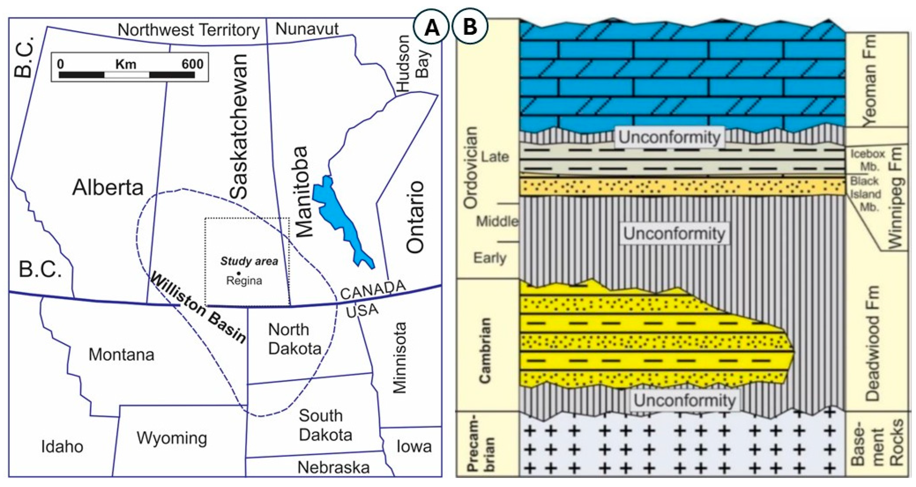
Saskatchewan is the second largest hydrocarbon-producing province in Canada, and its subsurface geology contains a significant number of reservoirs and caprocks that are part of the hydrocarbon systems of the province. Deep, hydrocarbon-depleted reservoirs and saline aquifers are excellent candidates for CCS. This study addresses the reservoir potential of a sandstone member which forms the lower part of the Late Ordovician Winnipeg Formation in Southeastern Saskatchewan. The formation occurs in the northern shelf of the Williston Basin. The basin extends from the Prairie Provinces of Canada (i.e., SW Manitoba, S. Saskatchewan, and SE Alberta) to the Dakotas and Montana in the USA [5] (Figure 1A).
The Winnipeg Formation is a siliciclastic lithostratigraphic unit that lies over the Cambrian sandstones of the Deadwood Formation and underlies the carbonates of the Yoeman Formation [6]. Figure 1B shows a simplified stratigraphic overview of the Ordovician System of the study area and illustrates that the formation consists of two members, the lower sandstone-dominated Black Island Member and the shale-dominated Icebox Member [6,7]. The formation is exposed along the west shore of Lake Winnipeg, but none of the outcrops show a complete stratigraphic section of this formation [8]. The formation accumulated under a shallow marine setting during the initial period of the northward expansion of the Late Ordovician transgression in the Williston Basin [6,9,10].
This study aims to explore the reservoir characteristics of the Black Island Member and its volumetric capacity for CO2 storage. This study intends to (i) describe the lithologic properties of the Black Island Member (BIM) of the Winnipeg Formation, (ii) analyze the reservoir quality of the member, and (iii) estimate the volumetric capacity of the member to decipher the member’s CO2 storage potential.

Figure 1.
(A) Location of the Williston Basin and delineation of the study area in SE Saskatchewan (modified from [6,11]. (B) Cambrian to Ordovician stratigraphy of the SE Saskatchewan and occurrence of the Winnipeg Formation and its two members: Black Island and Icebox. Unconformities bound the lower and upper boundaries of the Winnipeg Formation (adapted with permission from ref. [6]. Copyright year 2023, Copyright owner: Iqbal, N.).
2. Materials and Methods
The methodology adopted to achieve the objectives included (i) core logging and rock description, (ii) petrographic microfacies analysis, and (iii) porosity quantification by using point counting and thin-section image analysis, along with core porosity data obtained from GeoSCOUT (Calgary, AB, Canada). The point counting was based on photomicrograph image analysis from 46 thin sections. Photomicrographs taken of microfacies representative of each thin section were taken and drawn on a grid of 15 by 20 lines, and line intersections that occurred in pore spaces (blue epoxy) were recorded. The percentages relative to the 300 points were calculated (Figure 2A). Thin sections from forty-six samples were selected for this analysis. Digital image analyses, carried out using ImageJ Software (version 1.53j), were performed to calculate the total space of a digitally recognized pore-representing zones (Figure 2B,C). Porosity and permeability data obtained from core plugs analyzed by exploration/production companies were extracted from the GeoSCOUT database and used to complement the results obtained via point counting and image analysis. The porosity and permeability data were integrated with the average member thickness and its lateral (latitudinal and longitudinal) extensions within the study area. This allowed for the calculation of the member’s volumetric capacity to accommodate fluids, e.g., CO2 storage capacity.
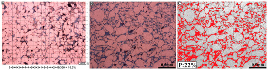
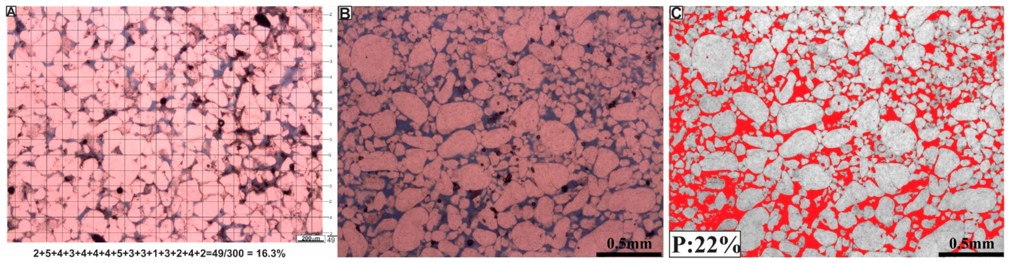
Figure 2.
(A) Thin-section photomicrograph with grid lines (15 × 20) for the purpose of point counting (300 points). This example shows a porosity of 16.3%. (B) Plain polarized thin-section photomicrograph, with the blue epoxy showing porous zones. (C) Same image as (B). ImageJ software was used for digital pore analysis. This software calculated pore spaces, represented by the red color.
3. Lithology and Reservoir Properties of the BIM
3.1. Lithologic Properties
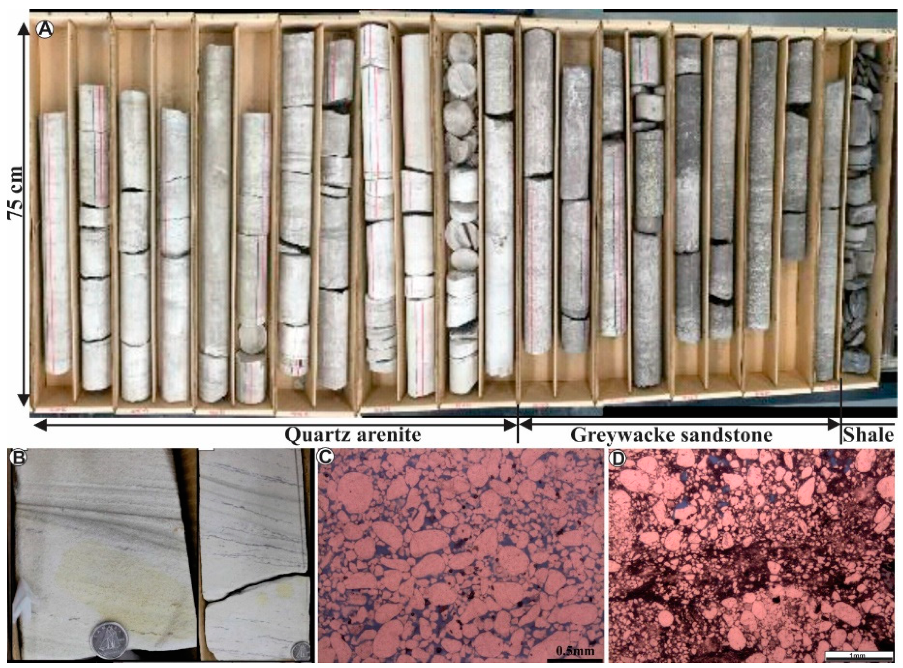
The core description and petrographic analysis of the Black Island Member revealed that the member consists of three lithofacies units. These units are made up of (i) quartz arenite sandstone, (ii) graywacke sandstone, and (iii) shale (Figure 3A). The quartz arenite unit is made of a clean sandstone, more than 90% of which comprises quartz grains. It is dominated by whitish to light gray, porous, moderately to well-sorted, medium- to coarse-grained, thickly bedded, burrowed to cross-laminated sandstone (Figure 3A–C). This lithofacies constitutes about 47% of the total volume of the member within the study area. The graywacke sandstone consists of both feldspathic and lithic graywacke. It is poorly sorted and contains fine- to coarse-grained, moderately to extensively burrowed, medium to dark gray sandstone (Figure 3A,D). This lithofacies constitutes about 44% of the Black Island Member. The shale lithofacies (~9%) is characterized by dark mudrock layers (mostly thin laminae that are inter-layred with the sandstone lithofacies).
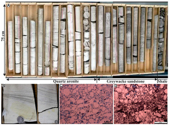
Figure 3.
(A) Example of a well core showing the major lithologic properties of the Black Island Member of the Winnipeg Formation. The lithologic units include quartz arenite, graywacke, and shale. (B) Cross-bedded, clean quartz arenite with streaks of shale (darker layers). (C) Thin-section photomicrograph of the quartz arenite. (D) Thin-section photomicrograph of the graywacke sandstone.
3.2. Reservoir Properties
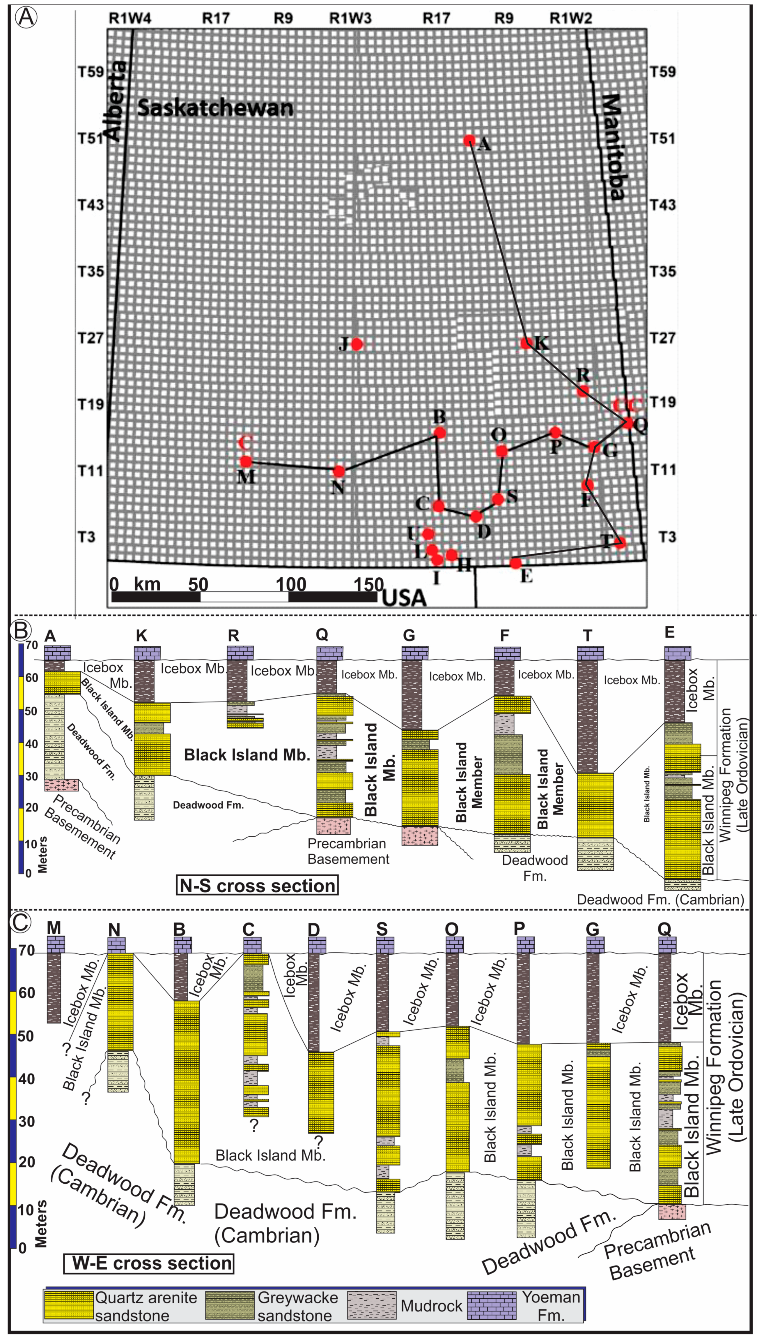
Reservoir characterization is the process used to quantitatively identify the volume of open spaces (porosity, f) within rocks and the ability of the pores to permeate fluids (permeability, K). Reservoir properties are extensively studied by geoscientific and engineering researchers, traditionally for petroleum and groundwater purposes, but more recently, they have been studied for their subsurface fluid storage capacity. The parameters required to determine the capacity of a rock’s pore spaces include the average porosity percentage and three-dimensional (3D) distribution of reservoir unit. The Black Island Member (BIM) is well preserved in subterraneous Southeastern Saskatchewan. This study explores the properties of the member and its reservoir capacity. In the study area, the thickness of the BIM varies from 7 m to 57 m (Figure 4A,B), with the average thickness being 31.6 m.
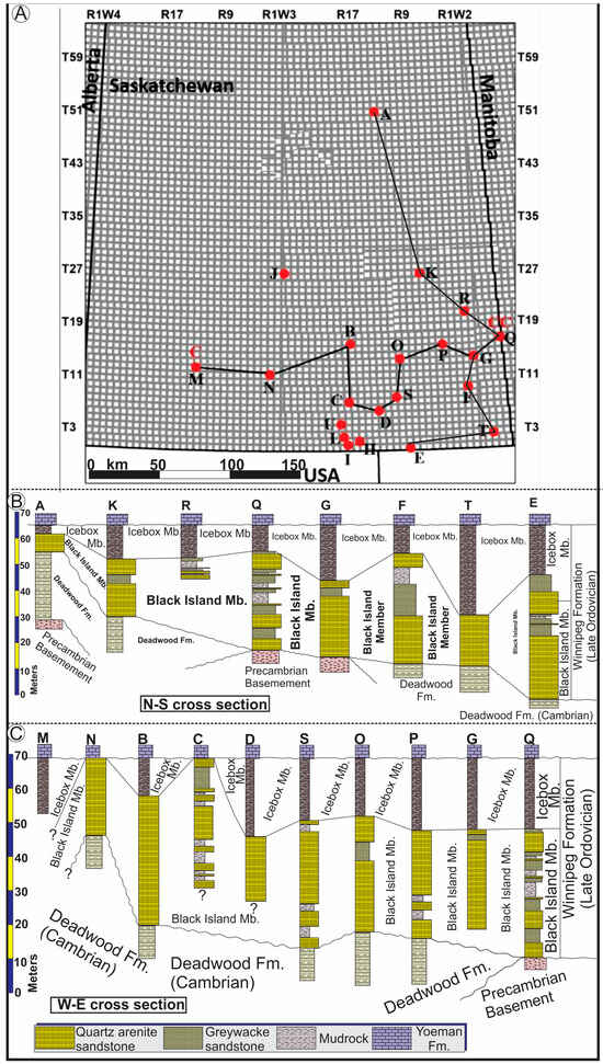
Figure 4.
(A) Township and range map of the study area and locations of the 21 cored wells (A to U). Descriptions of these cores constituted the base of our rock lithologic analysis of the Winnipeg Formation. The map also shows locations of the north–south and west–east cross sections shown in (B) and (C), respectively.
The two major lithofacies units of the member, the quartz arenite (47%) and the graywacke sandstone (44%) units, constitute 91% of the total volume of the member. Besides the volumetric content, the two members differ in their relative porosities, based on the point counting results. The quartz arenite is the cleaner facies, with an average porosity (ϕQA) of 21%, whereas that of the graywacke sandstone (ϕGW) is 8.7%. Figure 5 depicts the thickness distribution of the porous units (the two sandstone facies) of the Black Island Member. The porous units are thicker southeastward. Porosity variations are affected by different factors, such as depositional texture (clean quartz arenite versus poorly sorted, matrix-rich graywacke) and diagenetic influences, including cementation, compaction, dissolution, and fracturing.

Figure 5.
An isopach map showing the thickness distribution of the total porous units (quartz arenite and graywacke sandstone facies) of the Black Island Member. The porous units become thinner northward, possibly due to the relative lack of accommodation space in the shallower part of the depositional environment or post-Black Island Member erosional vacuity, or a combination of both.
3.3. Subsurface Porosity and Permeability Distribution
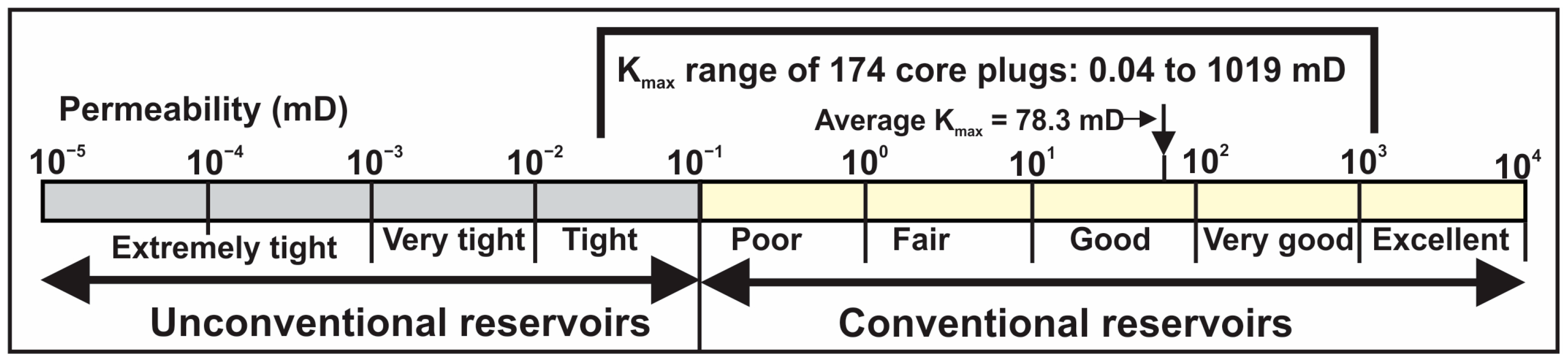
The actual porosity of any sedimentary rock results from the combination of the original textural depositional properties and subsequent diagenetic modifications [12,13,14,15]. The Black Island Member accumulated in a high- to medium-energy foreshore to lower offshore depositional environment [6]. The Winnipeg Formation is exposed along the northern edge of the Phanerozoic sequences of the Williston Basin in Saskatchewan and Manitoba and becomes gradually deeper to the south. In the study area, the actual burial depth of the formation is over 3300 m at the border with North Dakota [6]. Despite this relatively deep burial condition and the associated compaction potential of the overburden, the overall porosity of the sandstone facies of the Black Island Member is good and most of the permeability data occupies in the conventional reservoir permeability range [16]. This is most likely due to the late-stage dissolution of early-stage calcite cement. The pores within the sandstone units are also well interconnected, as indicated by the high permeability (Figure 6). Permeability data obtained from analyzed core plugs and stored in the GeoSCOUT system show a permeability range from slightly tight (0.04 milldarcy) to excellent (over 1 darcy). The average permeability is 78.3 millidarcy, classified as good permeability within the conventional reservoir category (Figure 7).
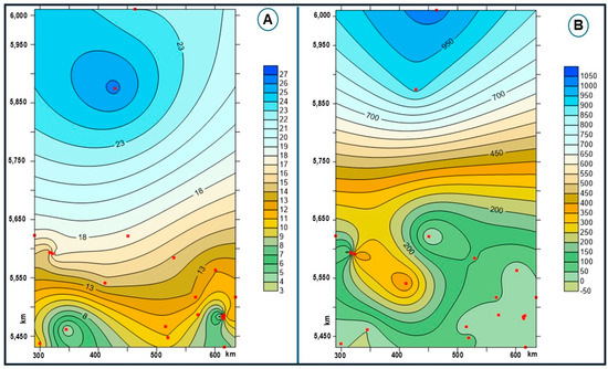
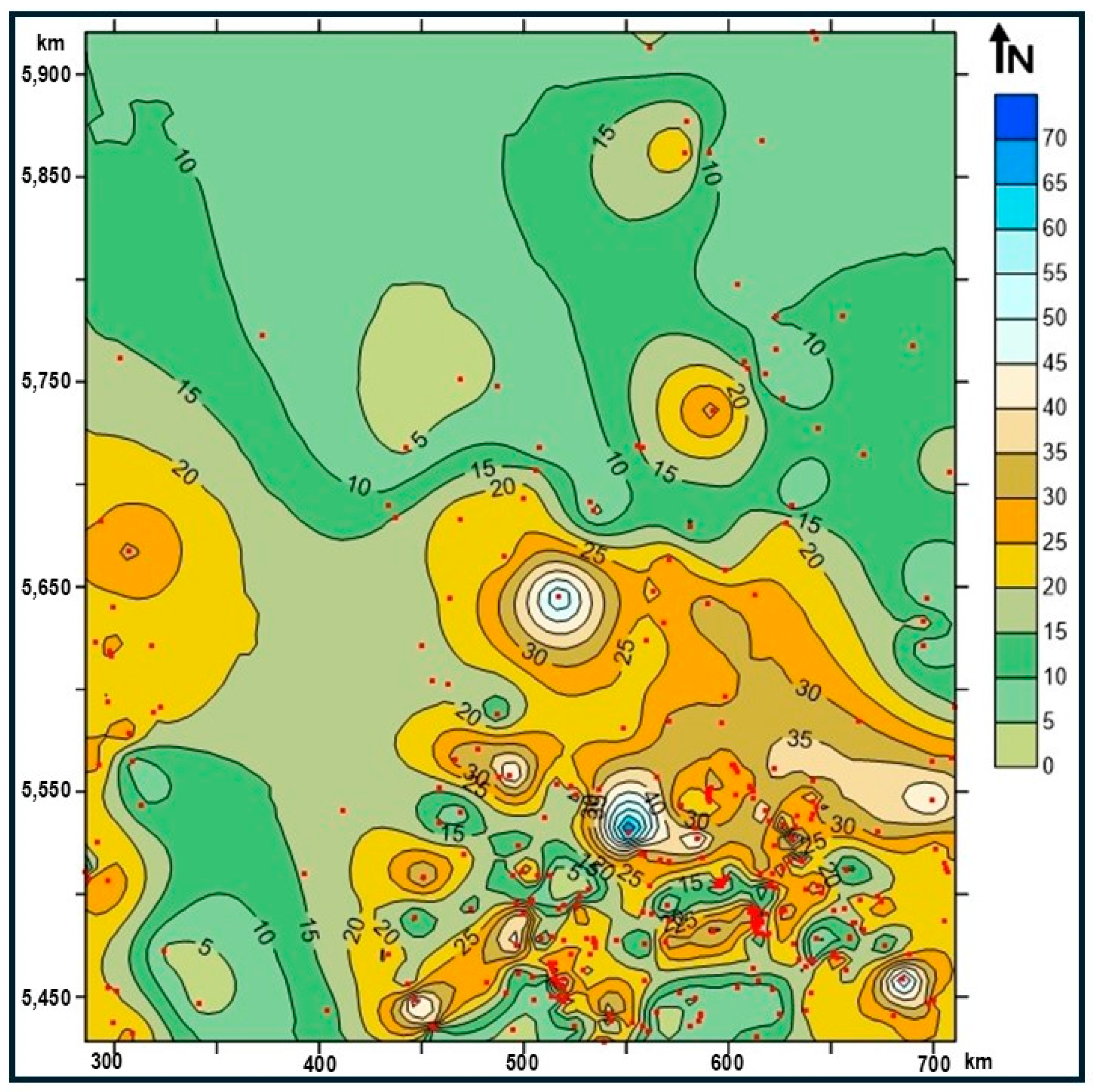
Figure 6.
(A) A map showing the areal porosity distribution of the sandstone lithofacies (the quartz arenite and the graywacke sandstones) of the study area. Porosity increases northward due to the quartz arenite facies being relatively cleaner than the graywacke facies. (B) A map showing the areal permeability distribution.

Figure 7.
Permeability ranges of conventional and unconventional reservoirs. The permeability (Kmax) of the BIM sandstones ranges from slightly tight to excellent, with an average permeability considered good (78.3 millidarcy).
3.4. Storage Space Capacity Potential (SSCP)
The parameters used for the calculation of SSCP include the volume of the BIM (VBIM), the product of the member’s latitudinal (X) and longitudinal (Y) distribution multiplied by the member’s average thickness (Z) (VBIM = X × Y × Z); the relative volumes of the porous units (the quartz arenite and graywacke sandstones: VQA and VGW, respectively); and the average porosities of the two sandstone lithofacies (ϕQA and ϕGW, respectively). Based on Figure 6, the latitudinal extension (the X value) of the study area is 450 km, whereas the longitudinal extension (the Y value) is 500 km. The average thickness of the Black Island Member (the Z value) is 31.6 m (0.0316 km). Thus, the calculation of SSCP, which includes the combination of the porosity volumes of the quartz arenite (ϕVQA) and the graywacke sandstone (ϕVGW), can be achieved through the following volumetric parameters:
- VBIM = X × Y × Z → 450 km × 500 km × 0.0316 km = 7110 km3.
- The volume of the quartz arenite portion of the member (VQA) is equal to the product of VBIM and the relative amount of quartz arenite (i.e., 47%). Thus, VQA = VBIM × 47% → 7110 km3 × 0.47 = 3341.7 km3.
- Similarly, the volume of the graywacke sandstone (VGW) is equal to the product of VBIM and the relative percentage of the graywacke facies (i.e., 44%). Thus, VGW = VBIM × 44% → 7110 km3 × 0.44 = 3128.4 km3
- The porosity volume of the quartz arenite facies (ϕVQA) is equal to the product of VQA and the average porosity percentage (i.e., 21%). Thus, ϕVQA = VQA × 21% → 3341.7 km × 21% = 702 km3.
- The porosity volume of the graywacke facies (ϕVGW) is equal to the product of VGW and the average porosity percentage of the graywacke sandstone (i.e., 8.7%). Thus, ϕVQA = VGW × 8.7%) → 3128.4 km3 × 8.7% = 272 km3.
- The total SSCP consists of the sum of the pore volume of the quartz arenite (ϕVQA) and that of the graywacke sandstone (ϕVGW). Thus, SSCP = 702 km3 + 272.2 km3 = 974 km3.
The enormous pore space of the sandstones of the Black Island Member, coupled with the good average permeability (78.3 millidarcy) (Figure 7), indicates that the member is an excellent geologic unit that can store massive amounts of fluid (e.g., CO2). This underscores the notion that the member has high potential for CCS. The member is overlain by the Icebox Member of the Winnipeg Formation. This upper member of the formation is dominated by a shale lithology, a unit that can be considered as a caprock that can potentially trap fluids injected into the underlying sandstone reservoir. However, the effectiveness of the sealing competency needs further scrutiny.
4. Conclusions
The Black Island Member of the Winnipeg Formation in Southern Saskatchewan is dominated by a sandstone lithology forming about 91% of the member. The subordinate shale content (~9%) is associated with the sandstone lithology. The latter consists of porous quartz arenite (47% of the member) and graywacke (44% of the member) facies. Analysis of the porosity and permeability data indicates that the sandstone facies have excellent reservoir properties. The lateral extension of the member within the study area (450 km by 500 km), the average thickness of the member (31.6 m), and the average porosity of the quartz arenite and graywacke facies (21% and 8.7%, respectively) facilitated the calculation of the storage space capacity of the Black Island Member, amounting to about 974 km3. This subterraneous space offers the potential to store an extensive amount of injected fluids (e.g., CO2). The member is overlain by a shale-dominated Icebox Member. This member is well distributed throughout the study area and has the potential to act as a caprock that can trap fluids within the underlying sandstone units of the Black Island Member.
Author Contributions
Conceptualization, O.S.H.; methodology, O.S.H. and N.I.; software, N.I.; validation, N.I. and O.S.H.; formal analysis, O.S.H. and N.I.; investigation, O.S.H. and N.I.; resources, O.S.H.; data curation, O.S.H. and N.I.; writing—original draft preparation, O.S.H. and N.I.; writing—review and editing, O.S.H. and N.I.; visualization, O.S.H. and N.I.; supervision, O.S.H.; project administration, O.S.H.; funding acquisition, O.S.H. All authors have read and agreed to the published version of the manuscript.
Funding
Saskatchewan Ministry of Economic Development, Geological Survey of Saskatchewan.
Institutional Review Board Statement
Not applicable.
Informed Consent Statement
Not applicable.
Data Availability Statement
The original contributions presented in the study are included in the article, further inquiries can be directed to the corresponding author.
Conflicts of Interest
The authors declare no conflicts of interest. N.I. was employed by Petro-Explorers Inc. The other author (O.S.H.) declares that the research was conducted in the absence of any commercial or financial relationships that could be construed as a potential conflict of interest.
References
- Kweku, D.W.; Bismark, O.; Maxwell, A.; Desmond, K.A.; Danso, K.B.; Oti-Mensah, E.A.; Quachie, A.T.; Adormaa, B.B. Greenhouse Effect: Greenhouse gases and their impact on global warming. J. Sci. Res. Rep. 2017, 17, 1–9. [Google Scholar] [CrossRef]
- Ledley, T.S.; Sundquist, E.T.; Schwartz, S.E.; Hall, D.K.; Fellows, J.D.; Killeen, T.L. Climate changes and greenhouse gases. Eos Trans. 1999, 80, 453–458. [Google Scholar] [CrossRef]
- UNFCCC. Paris Agreement. 2015. Available online: https://unfccc.int/sites/default/files/english_paris_agreement.pdf (accessed on 12 August 2024).
- Furre, N.-K.; Eikenb, O.; Alnesa, H.; Vevatnea, J.N.; Kiæra, A.F. 20 years of monitoring CO2-injection at Sleipner. Energy Procedia 2017, 114, 3916–3926. [Google Scholar] [CrossRef]
- Dorador, J.; Buatois, L.A.; Mángano, M.G.; Rodríguez-Tovar, F.J. Ichnologic and sedimentologic analysis of the Upper Ordovician Winnipeg Formation in southeastern Saskatchewan. Summ. Investig. 2014, 1, 15. [Google Scholar]
- Iqbal, N. Sedimentologic and Lithostratigraphic Properties and Reservoir Characterization of the Winnipeg Formation, Southern Saskatchewan. Master’s Thesis, University of Regina, Regina, SK, Canada, 2023; 112p. [Google Scholar]
- Iqbal, N.; Salad Hersi, O. Sedimentologic properties and depositional setting of the Black Island Member of the Late Ordovician Winnipeg Formation, Southeastern Saskatchewan. In Proceedings of the Geoconvention, Calgary, AB, Canada, 20–22 June 2022; Available online: https://geoconvention.com/wp-content/uploads/abstracts/2022/73454-sedimentologic-properties-and-depositional-setting.pdf. (accessed on 14 August 2024).
- Oberg, R. Winnipeg conodonts from Manitoba. J. Paleontol. 1966, 40, 130–147. [Google Scholar]
- Paterson, D.F. The Stratigraphy of the Winnipeg Formation (Ordovician) of Saskatchewan; Report No. 140; Department of Mineral Resources, Geological Science Branch (Sedimentary Geology Division): Regina, SK, Canada, 1971; pp. 1–57. [Google Scholar]
- McCabe, H.R. Reservoir potential of the Deadwood and Winnipeg formations, southwestern Manitoba. Natural Resources and Environment, Mineral Resources Division. Geol. Pap. 1978, 78, 54. [Google Scholar]
- Nimegeers, A.R. Stratigraphic Relationships and Depositional Model of Mississippian Midale Beds in the Steelman-Bienfait area, Southeastern Saskatchewan. Master’s Thesis, University of Regina, Regina, SK, Canada, 2006; 132p. [Google Scholar]
- Harris, P.M.; Kendall, C.G.; Lerche, I. Carbonate cementation—A brief review. In Carbonate Cements; Schneidermann, N., Harris, P., Eds.; SEPM Special Publication: Tulsa, OK, USA, 1985; Volume 36, pp. 79–95. [Google Scholar]
- Stonecipher, S.A. Applied Sandstone Diagenesis—Practical Petrographic Solutions for A Variety of Common Exploration, Development, and Production Problems; SEPM Short Course Notes; SEPM Society for Sedimentary Geology: Tulsa, OK, USA, 2000; Volume 50, pp. 1–143. [Google Scholar]
- Westphal, H.; Eberli, G.P.; Smith, L.B.; Grammer, G.M.; Kislak, J. Reservoir characterization of the Mississippian Madison Formation, Wind River basin. Wyoming. AAPG Bull. 2004, 88, 405–432. [Google Scholar] [CrossRef]
- Salad Hersi, O.; Abbasi, I.A.; Al-Harthy, A.; El-Ghali, M.A.K. Sequence stratigraphic framework and distribution of potential reservoirs: Early Cretaceous Qishn Formation, Dhofar, Southern Oman. Arab. J. Geosci. 2024, 17, 171. [Google Scholar] [CrossRef]
- Abuamarah, B.A.; Nabawyb, B.S.; Shehatac, A.M.; Kassema, O.M.K.; Ghrefata, H. Integrated geological and petrophysical characterization of Oligocene deep marine unconventional poor to tight sandstone gas reservoir. Mar. Pet. Geol. 2019, 109, 868–885. [Google Scholar] [CrossRef]
Disclaimer/Publisher’s Note: The statements, opinions and data contained in all publications are solely those of the individual author(s) and contributor(s) and not of MDPI and/or the editor(s). MDPI and/or the editor(s) disclaim responsibility for any injury to people or property resulting from any ideas, methods, instructions or products referred to in the content. |
© 2025 by the authors. Licensee MDPI, Basel, Switzerland. This article is an open access article distributed under the terms and conditions of the Creative Commons Attribution (CC BY) license (https://creativecommons.org/licenses/by/4.0/).