
Assessment and Analysis of Forest Fires in Bulgaria †


Abstract
1. Introduction
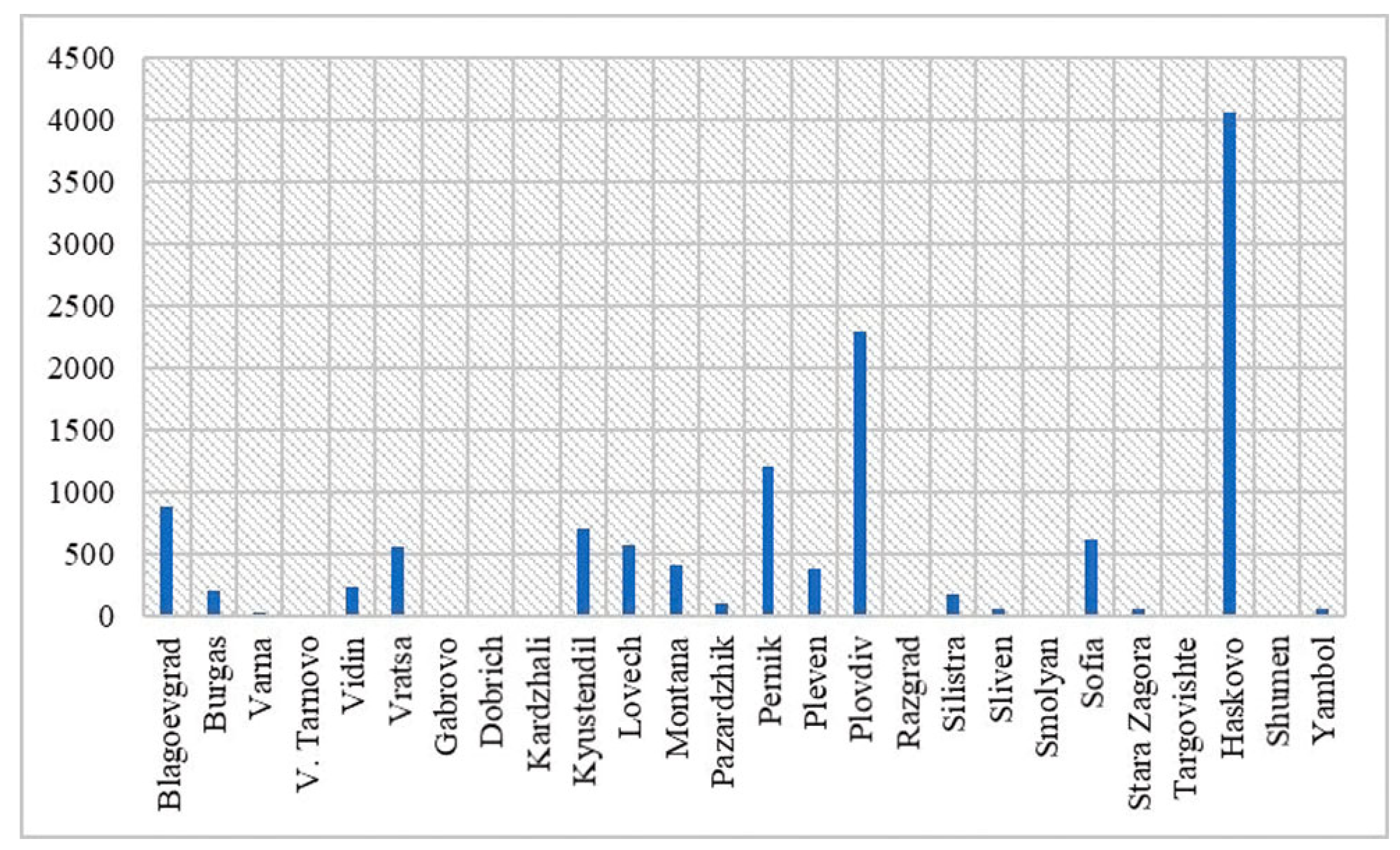
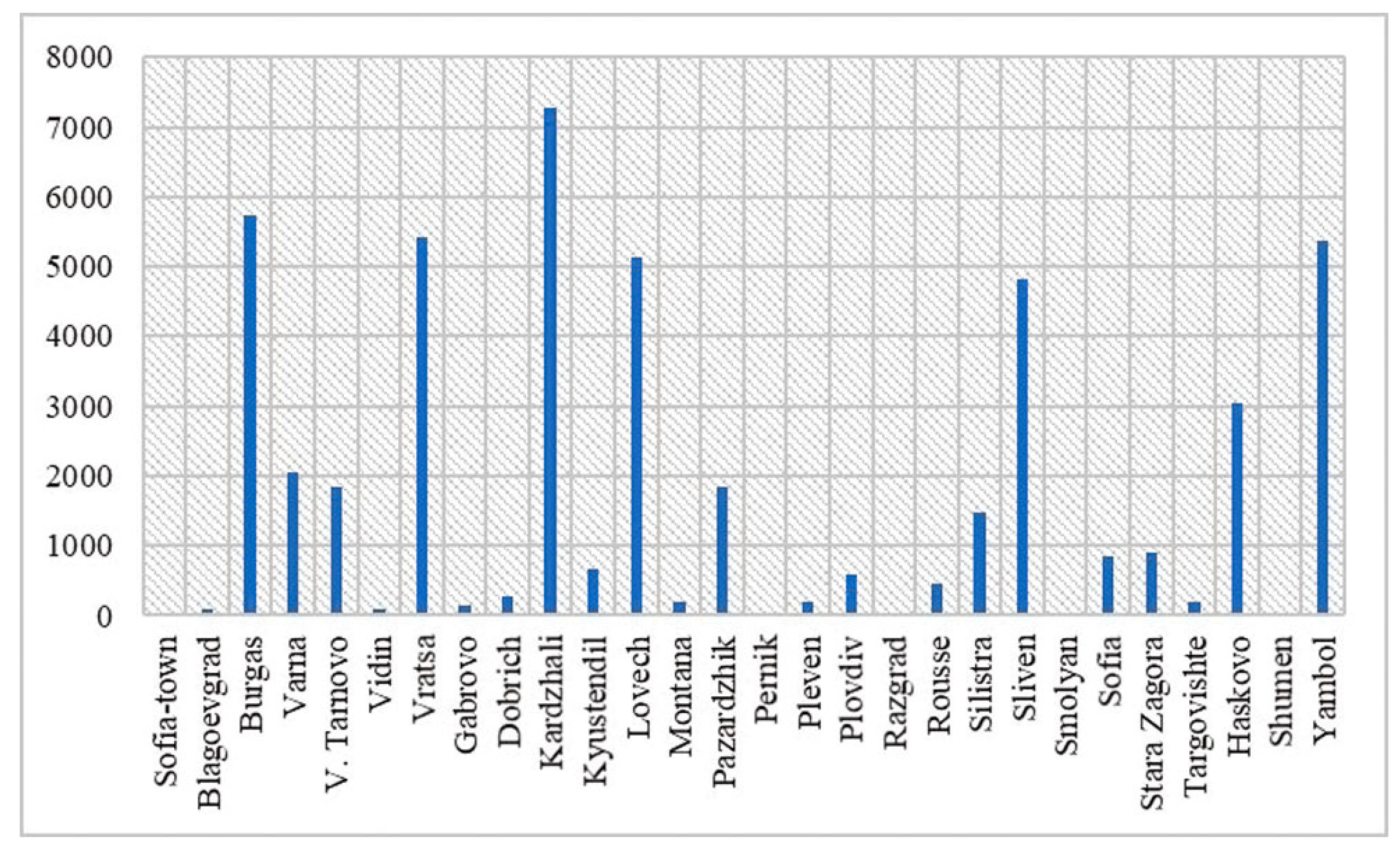
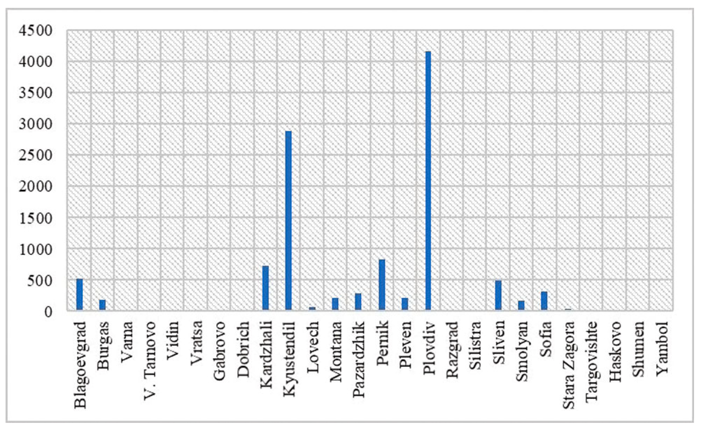
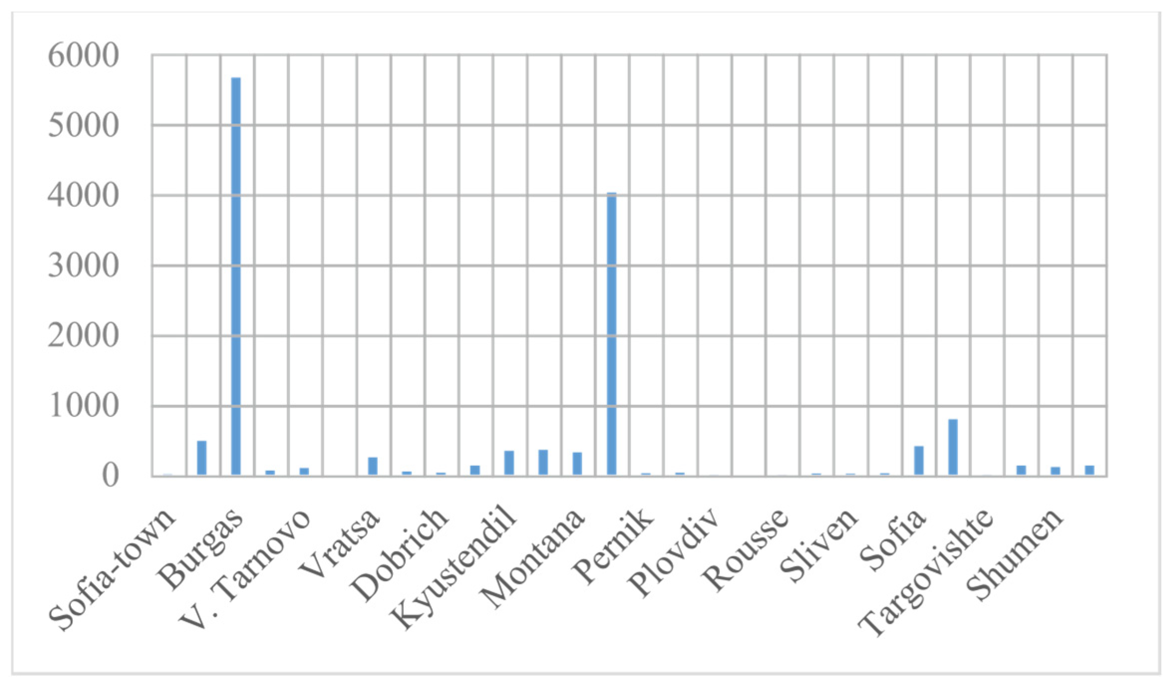
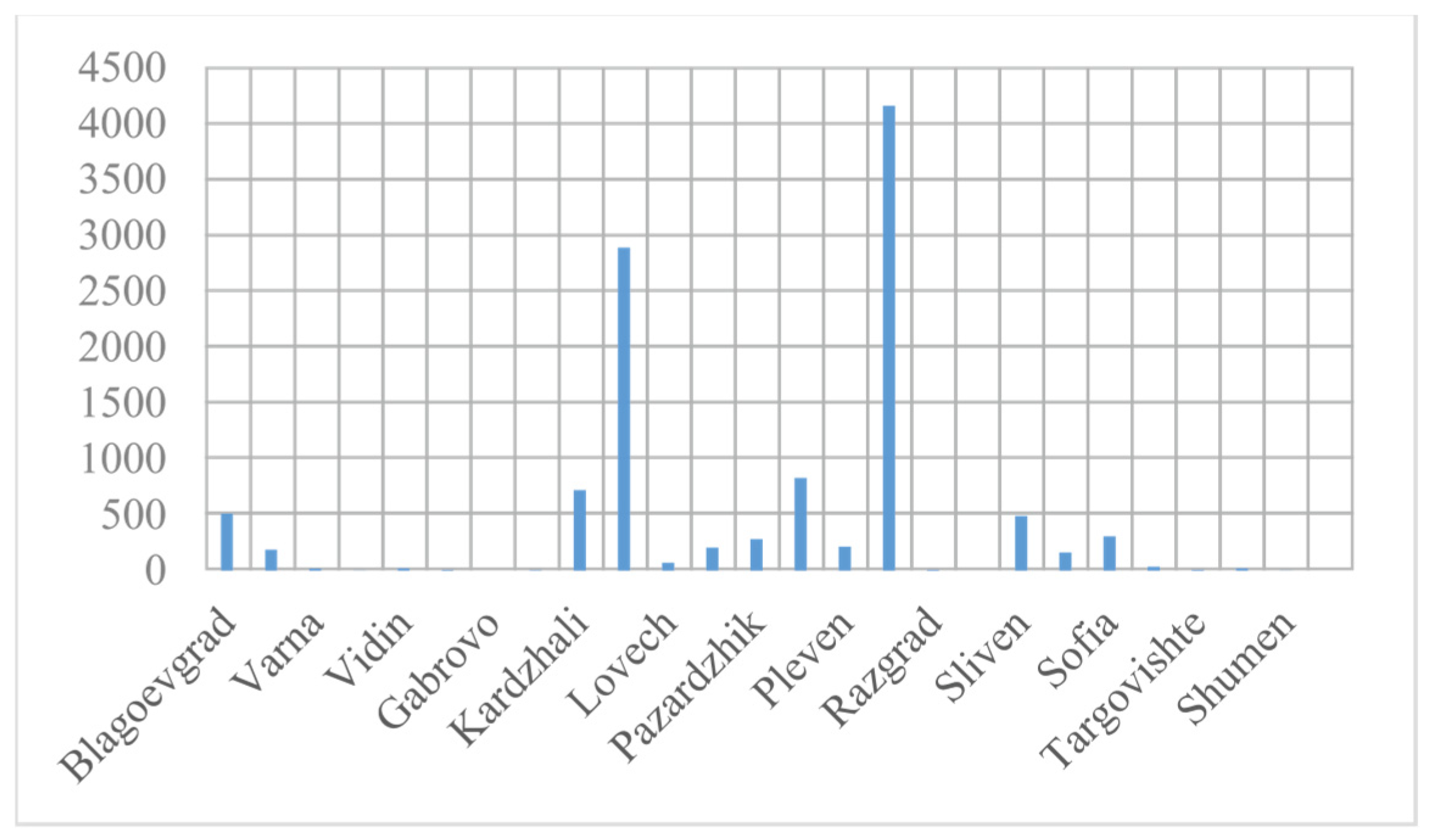
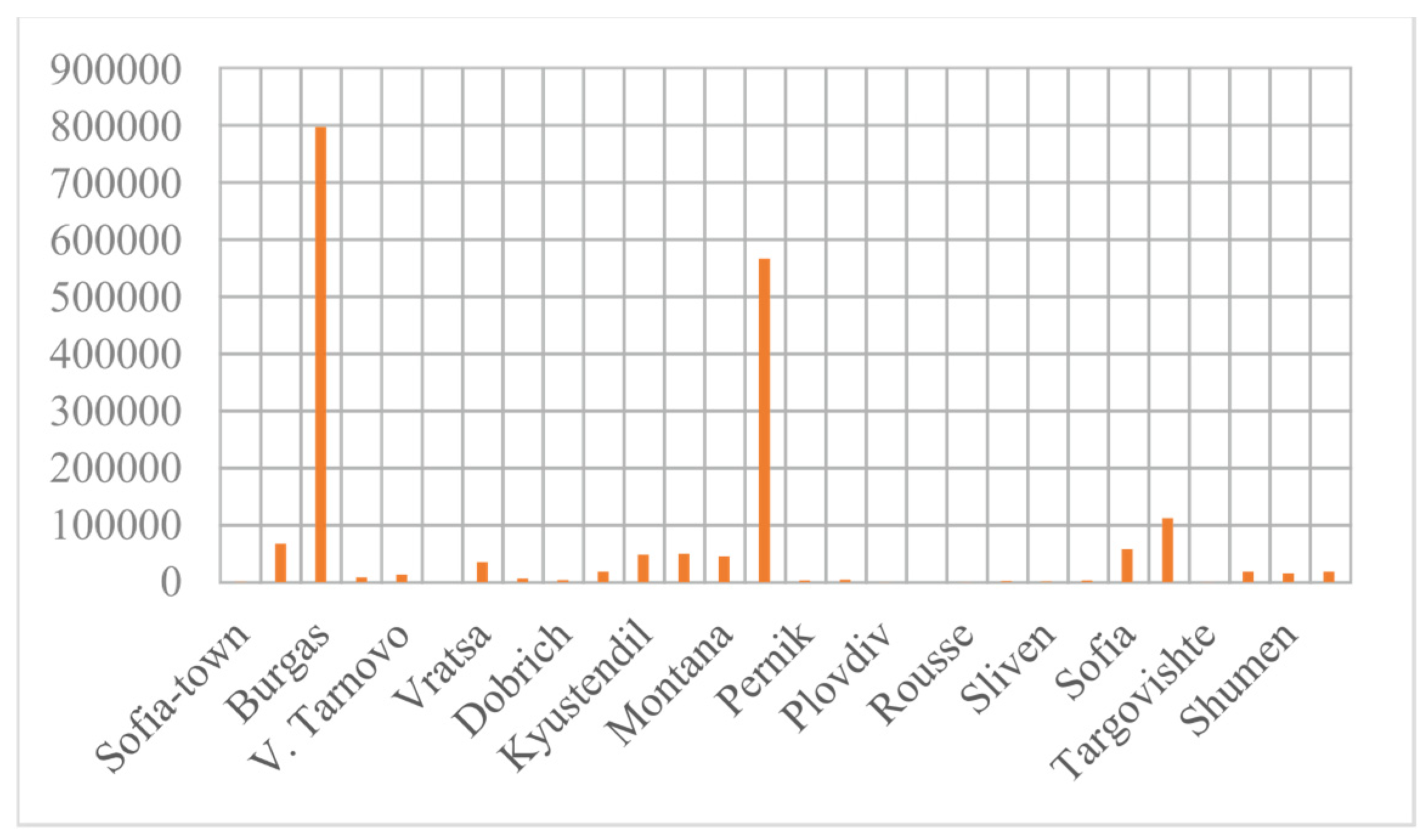
2. Analysis of Risk Assessment of Forest Fires
3. Calculation of the Amount of Carbon Dioxide Released
4. Conclusions
Author Contributions
Funding
Institutional Review Board Statement
Informed Consent Statement
Acknowledgments
Conflicts of Interest
References
- Halofsky, J.E.; Peterson, D.L.; Harvey, B.J. Changing wildfire, changing forests: The effects of climate change on fire regimes and vegetation in the Pacific Northwest, USA. Fire Ecol. 2020, 16, 4. [Google Scholar] [CrossRef]
- Sturrock, R.N.; Frankel, S.J.; Brown, A.V.; Hennon, P.E.; Kliejunas, J.T.; Lewis, K.J.; Worrall, J.J.; Woods, A.J. Climate change and forest diseases. Plant Pathol. 2011, 60, 133–149. [Google Scholar] [CrossRef]
- Carlini, E.M.; Michi, L.; Minto, L.; Chiereghin, F.; Genovese, C.; Foppa, R.; Fedrizzi, A. Forest fire or other dangerous situations: Safety procedure for overhead lines. In Proceedings of the AEIT International Annual Conference (AEIT), Florence, Italy, 18–20 September 2019; pp. 1–6. [Google Scholar] [CrossRef]
- Seidl, R.; Thom, D.; Kautz, M.; Martin-Benito, D.; Peltoniemi, M.; Vacchiano, G.; Wild, J.; Ascoli, D.; Petr, M.; Honkaniemi, J.; et al. Forest disturbances under climate change. Nat. Clim. Chang. 2017, 7, 395–402. [Google Scholar] [CrossRef] [PubMed]
- Johnson, B.R.; Ager, A.A.; Evers, C.R.; Hulse, D.W.; Nielsen-Pincus, M.; Sheehan, T.J.; Bolte, J.P. Exploring and Testing Wildfire Risk Decision-Making in the Face of Deep Uncertainty. Fire 2023, 6, 276. [Google Scholar] [CrossRef]
- Guo, M.; Li, J.; Wen, L.; Huang, S. Estimation of CO2 Emissions from Wildfires Using OCO-2 Data. Atmosphere 2019, 10, 581. [Google Scholar] [CrossRef]


| Kind of Tree | B, kW/m2 |
|---|---|
| Alder | 1417 |
| Clear | 1945 |
| Apple | 2184 |
| Beech | 2224 |
| Birch | 1484 |
| Cherry | 1452 |
| Chestnut | 1457 |
| Elm | 1419 |
| Oak | 2354 |
| Juniper | 1473 |
| Spruce | 1255 |
| Sycamore | 1579 |
| Walnut | 1797 |
| Willow | 1425 |
| Pine | 1287 |
| Fir | 1182 |
| Maple | 2045 |
Disclaimer/Publisher’s Note: The statements, opinions and data contained in all publications are solely those of the individual author(s) and contributor(s) and not of MDPI and/or the editor(s). MDPI and/or the editor(s) disclaim responsibility for any injury to people or property resulting from any ideas, methods, instructions or products referred to in the content. |
© 2024 by the authors. Licensee MDPI, Basel, Switzerland. This article is an open access article distributed under the terms and conditions of the Creative Commons Attribution (CC BY) license (https://creativecommons.org/licenses/by/4.0/).
Share and Cite
Velichkova, R.; Gieva, E.; Simova, I. Assessment and Analysis of Forest Fires in Bulgaria. Eng. Proc. 2024, 60, 2. https://doi.org/10.3390/engproc2024060002
Velichkova R, Gieva E, Simova I. Assessment and Analysis of Forest Fires in Bulgaria. Engineering Proceedings. 2024; 60(1):2. https://doi.org/10.3390/engproc2024060002
Chicago/Turabian StyleVelichkova, Rositsa, Elitsa Gieva, and Iskra Simova. 2024. "Assessment and Analysis of Forest Fires in Bulgaria" Engineering Proceedings 60, no. 1: 2. https://doi.org/10.3390/engproc2024060002
APA StyleVelichkova, R., Gieva, E., & Simova, I. (2024). Assessment and Analysis of Forest Fires in Bulgaria. Engineering Proceedings, 60(1), 2. https://doi.org/10.3390/engproc2024060002