Abstract
The tectonic activity produced by the interaction between the Eurasian and African plates continually generates high seismic activity and the possibility of tsunamis occurring in the Gulf of Cadiz, Spain. The occurrence of these phenomena and the associated threat implies the need to implement a seismogeodesic system made up of a GNSS receiver, a seismograph–accelerograph, and an inclinometer that allows for us to study the behavior of tectonic activity in the Gulf and adjacent areas. This system is installed in the Doñana biological station, Huelva, Spain, and sends continuous records to the control center located in the University of Cadiz, generating GNSS, seismic, accelerometric, and inclinometric time series, which, together with the implementation of geodetic and geophysical techniques, is capable of providing information on tectonic activity immediately. In this manuscript, the time series generated by the system have been analyzed, in addition to a specific seismic event that occurred in the study area.
1. Introduction
The south of the Iberian Peninsula and North Africa region is conditioned to the great Eurasian and African plates; this region corresponds to the transition between the oceanic edge and the continental edge where the Iberian Peninsula and Africa meet in the direction of Tunisia. It includes the Betic mountain ranges, the Gulf of Cadiz, the Alboran Sea, and the northern part of Morocco, characterized by a large complex of faults giving rise to a complex tectonic evolution and moderate seismic activity as a consequence of the convergence process between the Eurasian and African plates. Additionally, opposing movements are produced due to the difference in oceanic opening velocities in the Atlantic and the structural complexity of the Alboran domain.
In the Gulf of Cadiz, seismic activity is distributed in the east–west direction along a 100 km wide band located north of the Gulf; this tectonic activity (according to the magnitude, intensity, location, depth and other characteristics of the event) leads to the possibility of tsunami occurrence in the area. The tsunami that produced the greatest natural catastrophe in Spain was recorded on 1 November 1755, as a result of an earthquake of magnitude 8.5 Mw, located about 200 km from the cape of San Vicente in the S–W direction [1,2], (Figure 1).
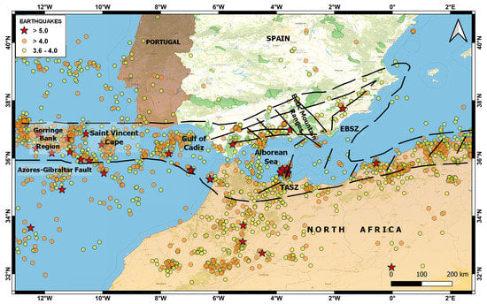
Figure 1.
Map showing the geodynamic context, seismic activity (2015–2022) and main faults of the southern region of the Iberian Peninsula and North Africa. The most important faults are: Gorringe Bank Region, Gulf of Cadiz, Azores–Gibraltar Fault, Saint Vincent Cape, Alboran Sea, Betic Mountain Ranges, Eastern Betic Shear Zone (EBSZ), and Trans–Alboran Shear Zone (TASZ).
The consequent dangerousness of a high-magnitude earthquake and the possible associated tsunami in the Gulf of Cadiz implies the need and motivation to develop and implement a seismogeodetic system that allows for the monitoring and surveillance of the tectonic activity in the area. This system comprises geodetic and geophysical techniques capable of providing immediate information on tectonic activity to understand, assess and minimize potential associated hazards.
The Seismogeodetic System is composed of a seismograph combined with a MEMS type-three-component (E, N, Z) accelerometer, a low-cost Tilt Data Logger, and a multi-frequency GNSS-GPS receiver (DONA). It is located in the Doñana Biological Station (EBD), in the Doñana National Park, Huelva, Spain. The main objective is to obtain a set of multiparametric time series (geodetic, seismic, acelerographic, and inclinometry) in real-time and/or deferred that, together with geodetic and geophysical techniques, can generate immediate information to monitor the tectonic activity of the Gulf of Cadiz and adjacent areas to minimize the possible associated risks. Other objectives will be the correlation between the different disciplines, time series, and results, in addition to their integration capacity in a regional EWS.
This system is complemented by a network of cGNSS stations (AYAM (“Ayamonte“ Town Hall) VEJE (Public Library of “Vejer de la Frontera”), VALV (Valverde del Camino Town Hall), PGUZ (Town Hall of “Puebla de Guzmán”) and UCA1 (University of Cadiz) distributed homogeneously along the first coastline of the Gulf of Cadiz and which, like the seismogeodetic system, transmits records in real-time to the control center located in the LAGC–UCA.
This manuscript presents a description of the seismogeodesic system installed in “EBD”, the techniques used for the treatment and processing of the records, as well as an analysis of the time series generated by the system, emphasizing the GNSS-GPS records, to learn the tectonic behavior of the study area. In addition, to illustrate the scope of the system, we show the results obtained from the 4.4 Mw earthquake that occurred on 1 January 2022 in the Gulf of Cadiz.
2. Methodology
Seismogeodetic System Description (Hardware, Software and Processing Techniques)
The Seismogeodetic System is made up of the instruments: A Leica “GR30” GNSS Receiver [3], a Biaxial Digital Tilt Logger “DTL202B” [4], a Raspberry Shake “RS4D” Seismometer–acelerometer [5], a Vaisala Weather Transmitter “WXT520” [6], electrical supply equipment, and two devices (router and switch) for data transmission. The sensors “DTL202B” and “RS4D” are installed in a concrete chamber at 1 m depth, and the sensors “GR30” and “WXT520” were installed in a metal structure or tripod near the concrete chamber. The control center located in the LAGC–UCA is made up of three servers: a server for the virtual infrastructure “Citrix”, a main storage “NAS”, and a mirror data backup.
For the transmission and reception of the data produced by the system, a communication network was established using the following protocols: VPN, which establishes an encrypted connection over the Internet from a primary host to a destination host, and provides connection security and remote control [7]. SFTP also runs on “SSH” service and offers reliable and secure data transfer [8]. RSync service is used for automatic data storage, synchronization, and replication, and runs recursively and incrementally between two hosts [9].
For the time synchronization of the inclinometer (DTL202B) we used the “NTP” service, which is designed to synchronize the clocks of devices over a network connected to a time server, on a common “UTC” time base [10]. For the time synchronization of the seismic records (seismometer “RS4D”), we used the USB GNSS receiver “UBX-M8030” [11], which connects to different satellites to learn their position and navigation time. The data are sent from the Doñana Biological Station to the control center via the “CSIC” VPN connection, which offers greater security regarding the transmission, reception, and availability of the data. The records produced by the prototype are automatically stored on a main NAS server [12], and then distributed to the data processing, and filtering modules (these modules are part of the virtual infrastructure of the control center), (Figure 2).
The software used in the development and implementation of the prototype is divided into three modules (acquisition, processing, and filtering modules). The acquisition module manages, stores, and visualizes the data produced from the different sensors of the prototype. Seismic data generated by the “RS4D” seismograph are managed and visualized using the SWARM application [13], an open-source Java application created to visualize and analyze seismic waveforms in real-time; this can connect to different sources of static data, dynamic data, and common waveforms server: Earthworm, Winston, SeisComp, and SeedLink. GNSS observations are managed through a local data repository that facilitates data management, sharing, and data searching.
The processing module is dedicated to the treatment, quality control, and processing of the multiparametric data produced by the prototype. The software used for the seismic records is “SEISAN”: a free, multiplatform software, useful for processing the waveforms generated by the earthquakes that occurred in the Gulf of Cadiz and recorded by seismograph “RS4D” [14]. The data generated by the “DTL202B” inclinometer are processed with the proprietary “DT Logger Host” software, which also allows us to visualize the results simply and quickly.
For GNSS data processing, we use the scientific software “BERNESE”, developed by “AIUB” [15,16], and “GIPSY”, developed by “JPL” [17], both of which require a license for use and are under permanent development. The GNSS processing techniques that were used are: PPP, Relative, and Kinematic.
In the filtering module, different mathematical and statistical techniques are applied for signal processing, the correction of abnormal values, and reductions in the noise level of the time series. For this purpose, data analysis and filtering techniques are used, which are methodologically grouped into initial filters (1–σ, 2–σ, and outliers), analytical filters (Kalman & Wavelets) and statistical filters (ARMA & ARIMA). This filtering software was developed using multiplatform and free-to-use statistical language “R” [18].

Figure 2.
Figure showing the network diagram and hardware components of the prototype seismogeodetic system (communications, sensors, servers, virtual machines, NAS, mirror backup, etc.). It is divided into three parts: Prototype Seismogeodetic (Doñana Station), UCA–HUB, and Control Center (LAGC). Initially, the prototype, and the UCA–HUB are interconnected by the VPN service provided by the “CSIC”, facilitating data transmission over the Internet to the management and control center, which has a “Citrix XenServer” [19] virtual infrastructure with virtual machines that have services and applications dedicated to the automatic acquisition, processing, visualization, and filtering of data.

3. Results
Case Study: 4.4 Mw Earthquake That Occurred on 1 January 2022, in the Gulf of Cadiz
In the last two years, several earthquakes have been recorded in the Gulf of Cadiz; however, they have not been of high magnitude nor have they occurred very close to the seismogeodetic system installed in the EBD. However, a case study was included to illustrate the purpose and scope of the prototype. The earthquake analyzed in this work occurred at 21:03:49 (UTC) on 1 January 2022, of magnitude 4.4 Mw, whose epicenter was located about 130 km southwest of Doñana, Huelva, Spain (Figure 3).
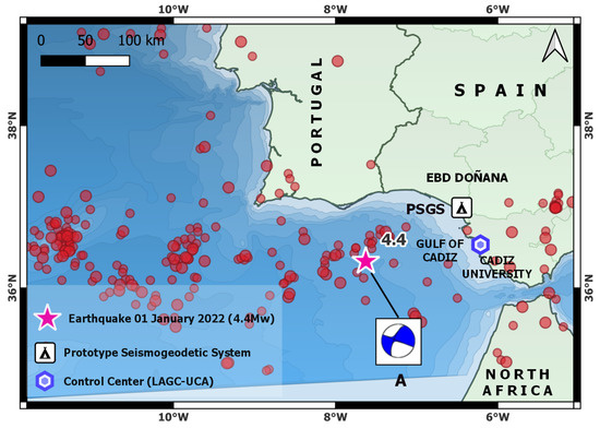
Figure 3.
Map showing the location of the 4.4 Mw earthquake that occurred on 1 January 2022 in the Gulf of Cadiz (LAT = 36.3276; LON = 7.6271; Depth 6 Km) recorded by the prototype, the seismic events greater than 3.5 Mw occurred in the Gulf of Cadiz and surroundings between 2015 and 2022 (events taken from the public seismic catalog of IGN, Spain), and the generated focal mechanism (A).
Regarding the kinematic GNSS processing, we observe that the 3D evolution of the GNSS receiver antenna position occurred 45s after the seismic event; there is also a small but significant displacement in the “N” and “U” components. However, the component “E” shows a smaller displacement than the previous ones (Figure 4). This earthquake lacks features that allow for the production of highly significant GNSS kinematic records to be correlated with seismic, accelerometric, or inclinometry records.
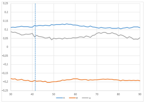
Figure 4.
East, North, Up components of the GNSS time series (1Hz sample rate) for the position of the “GR30” receiver seconds after the magnitude 4.4 Mw earthquake of 1 January 2022, with epicenter about 130 km southwest of Doñana, Huelva, Spain. A small change in the trend is shown 45s (approximately) after the event occurred; this corresponds to the arrival of the seismic wave.
In the seismic signal of this earthquake, a low signal-to-noise ratio was found at certain periods of time, which allowed for the use of a first filter of 0.5 to 10 Hz and a later one of 2 to 8 Hz, (Figure 5 ). The study of the focal mechanism shows the following parameters: “Double pair, plane A”; average azimuth of 112, average dip of 89, and a slip angle of 156; “Double pair, plane B”; average azimuth of 203, average dip of 86, and slip angle of 1. This solution presents a strike-slip faulting with NW–SE trending “P” axis, according to the NW–SE to WNW–ESE direction of Eurasian plate convergence. This mechanism is similar to previous moment tensor solutions in the Gulf of Cadiz, [20,21,22], (Figure 5A). In this case study, we also included the inclinometry records at the time of the seismic event on 1 January 2022 (Figure 6).
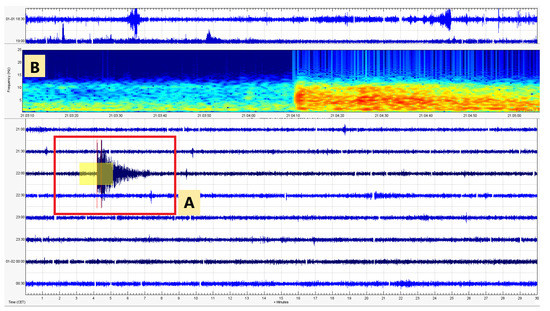
Figure 5.
Figure showing the seismogram (A) and spectrogram (B) of the earthquake that occurred on 1 January 2022 at 22:03:49 (local time), using the free softwares SEISAN and SWARM, registered by the RS4D seismometer integrated in the prototype.
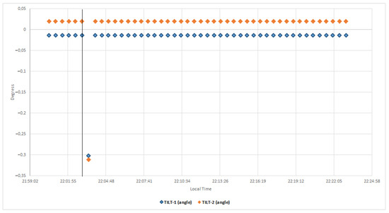
Figure 6.
Figure showing the inclinometry records (30s sample rate) where the displacement produced in both sensors (Tilt 1, Tilt2) is observed, corresponding to the arrival of the seismic wave of the 4.4 Mw earthquake that occurred on January 1, 2022 in the gulf of Cadiz.
4. Conclusions
This seismogeodetic system generates multiparameter time series (seismic, accelerographic, geodetic and inclinometry) in real and deferred time, which allows for us to learn the evolution of tectonic activity in the Gulf of Cadiz and adjacent areas, as well as possible associated tsunamis. A priority of the system is the ability to provide immediate information on the tectonic activity of the Gulf of Cadiz, based on the deformation parameter and its variability (velocity and acceleration), in order to minimize possible risks. Another objective of the implementation of this system is the correlation of the different time series produced and their results, in addition to its integration capacity in a regional EWS.
The high-frequency GPS observations show that system GNSS is an excellent tool for measuring large displacements in areas near earthquakes, where the seismographs due to the limits in their dynamic range are saturated, impeding the correct calculation of location and magnitude, when in fact, this information is basic for the detection and rapid evaluation of the seismic event. Therefore, the seismogeodetic systems based on the integration of GNSS–GPS receptors and accelerometers complement seismic networks in moderate-magnitude earthquakes, but will be essential to the occurrence of high-magnitude earthquakes [23,24,25].
We analyzed the time series of the cGNSS station DONA (Figure 7), which is a fundamental part of the described seismogeodetic system. The relative processing technique was used with the cGNSS reference stations VILL and YEBE, located in the province of Madrid, Spain. Both stations belong to the international network IGS. GNSS processing was performed with the BERNESE scientific software, using the ITRF14 reference frame. The years analyzed were from 2016 to 2022; the results show the following deformation values per component (E, N, U):
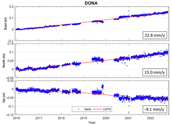
Figure 7.
Figure showing the results (E, N, U) of the time series of the cGNSS station “DONA”, the GNSS processing was performed with the BERNESE scientific software using ITRF14 reference frame.
Author Contributions
Conceptualization, J.R.-Z., M.B. and J.G.; methodology, J.R.-Z., B.R. and M.B.; software, J.R.-Z., V.J. and P.B.; validation, M.B. and J.G.; formal analysis, J.R.-Z., B.R., V.J., J.G. and M.B.; investigation, J.R.-Z., V.J., J.G. and M.B.; resources, M.B.; data curation, J.R.-Z., J.G., P.B. and V.J.; writing—original draft preparation, J.R.-Z. and M.B.; writing—review and editing, J.R.-Z., M.B. and J.G.; visualization J.R.-Z. and B.R; supervision, M.B. and J.G. All authors have read and agreed to the published version of the manuscript.
Funding
The design and implementation of the seismogeodetic system were possible thanks to the resources and funds of the astronomy, geodesy, and cartography laboratory of the University of Cadiz, directed by the principal researcher Dr. D. Manuel Berrocoso Domínguez.
Institutional Review Board Statement
Not applicable.
Informed Consent Statement
Not applicable.
Data Availability Statement
The seismic data shown in this manuscript belong to the public seismic catalog of the National Geographic Institute of Spain (IGN), https://www.ign.es/web/ign/portal/sis-catalogo-terremotos. The data generated by the seismogeodetic system belongs to the laboratory of astronomy, geodesy and cartography of the University of Cádiz (LAGC-UCA), https://lagc.uca.es/.
Acknowledgments
The development and implementation of the prototype seismogeodetic system described in this manuscript has been carried out with the support of: University of Cadiz, the Spanish National Research Council (CSIC) and the working group of the Doñana Biological Station (EBD) located in the Doñana National Park, Huelva, Spain.
Conflicts of Interest
The authors declare no conflict of interest.
Abbreviations
The following abbreviations are used in this manuscript:
| AIUB | Astronomical Institute of the University of Bern |
| CATS | Create and Analyze Time Series |
| cGPS | Continuous Global Positioning System |
| CSIC | Consejo Superior de Investigaciones Científicas |
| EBD | Estación Biológica Doñana |
| EWS | Early Warning System |
| GPS | Global Positioning System |
| GNSS | Global Navigation Satellite System |
| IGN | Instituto Geográfico Nacional |
| IGS | International GNSS Services |
| ITRF | Internacional Terrestrial Reference Frame |
| JPL | Jet Propulsion Laboratory |
| LAGC | Laboratorio de Astronomía Geodesia y Cartogrfía |
| MEMS | Micro Electro Mechanical Systems |
| NAS | Network Attached Storage |
| NTP | Network Time Protocol |
| PPP | Precise Point Positioning |
| RSync | Remote Syncronization |
| UCA | Universidad de Cádiz |
| UTC | Universal Time Coordinated |
| VPN | Virtual Network Protocol |
References
- Baptista, M.A.; Miranda, J.M.; Chierici, F.; Zitellini, N. New study of the 1755 earthquake source based on multi–channel seismic survey data and tsunami modeling. Nat. Hazards Earth Syst. Sci. 2003, 3, 333–340. [Google Scholar] [CrossRef]
- Baptista, M.A.; Miranda, J.M. Revision of the Portuguese catalog of tsunamis. Nat. Hazards Earth Syst. Sci. 2009, 9, 25–42. [Google Scholar] [CrossRef]
- Leica Geosystems Official Website. Leica GR30 GNSS Receiver Datasheet. Available online: https://leica-geosystems.com/en-gb/products/gnss-reference-networks/receivers/leica-gr50-and-gr30 (accessed on 11 September 2020).
- RST Instruments Official Website. Digital Tilt Loggers Specifications. Available online: https://rstinstruments.com/product/dtl201b-dtl202b-uniaxial-biaxial-digital-tilt-loggers/ (accessed on 10 November 2021).
- Raspberry Official Website. Raspberry Shake RS4D Specifications Manual. Available online: https://manual.raspberryshake.org/_downloads/SpecificationsforRaspberryShake4DMEMSV4.pdf (accessed on 11 November 2021).
- Vaisala Instruments Official Website. Vaisala “WKT520” User Guide. Available online: https://www.vaisala.com/sites/default/files/documents/M210906EN-C.pdf (accessed on 21 September 2020).
- Cisco System Official Website. What Is a VPN? Available online: https://www.cisco.com/c/en/us/products/security/vpn-endpoint-security-clients/what-is-vpn.html (accessed on 21 September 2021).
- SSH Home Page. SFTP File Transfer Protocol-Get SFTP Client & Server. Available online: https://www.ssh.com/academy/ssh/sftp (accessed on 10 September 2021).
- Rsync Official Website. Rsync Home Page. Available online: https://rsync.samba.org/ (accessed on 11 September 2021).
- NTP Official Website. Network Time Foundation’s NTP Support Wiki. Available online: https://support.ntp.org/bin/view/Main/WebHome (accessed on 1 October 2021).
- Ublox Official Website. UBlox USB GNSS Receiver Manual. Available online: http://bit.ly/QGPgnss (accessed on 14 February 2021).
- Synology Official Website. Synology Hardware Specifications. Available online: https://www.synology.com/es-es/products/RS1221+ (accessed on 10 September 2019).
- USGS Official Website. SWARM Home Page. Available online: https://volcanoes.usgs.gov/software/swarm/index.shtml (accessed on 10 January 2021).
- SEISAN Official Website. SEISAN Home Page. Available online: http://www.seisan.info/ (accessed on 19 January 2021).
- Bernese GNSS Software Official Website. Bernese Software Home Page. Available online: http://www.bernese.unibe.ch/ (accessed on 5 January 2021).
- Dach, R.; Lutz, S.; Walser, P.; Fridez, P. Bernese GNSS Software Version 5.2. User Manual; Astronomical Institute, University of Bern, Bern Open Publishing: Bern, Switzerland, 2015; ISBN 978-3-906813-05-9. Available online: https://boris.unibe.ch/id/eprint/72297 (accessed on 10 January 2021).
- UNAVCO Official Website. Gipsy–Oasis Description. Available online: https://www.unavco.org/software/data-processing/postprocessing/gipsy/gipsy.html (accessed on 15 January 2021).
- Barba, P.; Rosado, B.; Ramírez–Zelaya, J.; Berrocoso, M. Comparative Analysis of Statistical and Analytical Techniques for the Study of GNSS Geodetic Time Series. Eng. Proc. 2004, 5, 21. [Google Scholar] [CrossRef]
- Citrix Xen Server Official Website. XenServer 7.0 Standard Edition Web Page. Available online: https://www.citrix.com/es-es/downloads/citrix-hypervisor/product-software/xenserver-70-standard-edition.html (accessed on 15 February 2019).
- Stich, D.; Mancilla, F.; Morales, J. Crust–mantle coupling in the Gulf of Cadiz (SW–Iberia). Geophys. Res. Lett. 2005, 32, L13306. [Google Scholar] [CrossRef]
- Stich, D.; Martin, R.; Morales, J. Moment tensor inversion for Iberia–Maghreb earthquakes (2005–2008). Tectonophysics 2010, 483, 390–398. [Google Scholar] [CrossRef]
- Martín, R.; Stich, D.; Morales, J.; Mancilla, F. Moment tensor solutions for the Iberian–Maghreb region during the IberArray deployment (2009–2013). Tectonophysics 2015, 663, 261–274. [Google Scholar] [CrossRef]
- Larson, K.M.; Bodin, P.; Gomberg, J. Using 1–Hz GPS Data to Measure Deformations Caused by the Denali Fault Earthquake. Science 2003, 300, 1421–1424. [Google Scholar] [CrossRef]
- Shu, Y.; Fang, R.; Geng, J.; Zhao, Q.; Liu, J. Broadband velocities and displacements from integrated GPS and accelerometer data for high--rate seismogeodesy. Geophys. Res. Lett. 2018, 45, 8939–8948. [Google Scholar] [CrossRef]
- Bilich, A.; Cassidy, J.F.; Larson, K.M. GPS Seismology: Application to the 2002 Mw 7.9 Denali Fault Earthquake. Bull. Seismol. Soc. Am. 2008, 98, 593–606. [Google Scholar] [CrossRef]


Disclaimer/Publisher’s Note: The statements, opinions and data contained in all publications are solely those of the individual author(s) and contributor(s) and not of MDPI and/or the editor(s). MDPI and/or the editor(s) disclaim responsibility for any injury to people or property resulting from any ideas, methods, instructions or products referred to in the content. |
© 2023 by the authors. Licensee MDPI, Basel, Switzerland. This article is an open access article distributed under the terms and conditions of the Creative Commons Attribution (CC BY) license (https://creativecommons.org/licenses/by/4.0/).