Proceeding Paper

Methods and Scenario Analysis into Regional Area Participatory Planning of Sustainable Development: The “Roses Valley” in Southern Morocco, A Case Study †

Institute of Mediterranean Studies (ISMed), National Research Council (CNR), 80134 Naples, Italy
*
Author to whom correspondence should be addressed.
Presented at the 9th International Conference on Time Series and Forecasting, Gran Canaria, Spain, 12–14 July 2023.
Eng. Proc. 2023, 39(1), 8; https://doi.org/10.3390/engproc2023039008
Published: 28 June 2023
(This article belongs to the Proceedings of The 9th International Conference on Time Series and Forecasting)

Abstract

:
As the global environmental crisis grows in scale and complexity, land protection experts and policy makers are increasingly called upon to make decisions, despite high levels of uncertainty, limited resources and insufficient or, conversely, available but unintegrated data. Efforts to protect biodiversity at the national and, especially, the local level, which aim to achieve sustainable development in territories and local communities, require the incorporation of social, economic and political considerations to ensure that participatory planning of strategies is adopted and undertaken. With this issue in mind, the geographical focus chosen for this contribution is the territory of the Valley of Roses located in the southern area of Morocco. From a methodological point of view, this paper will address the state of the existing literature on sustainable development and the good practices implemented in studied territories. The final objective, which is related to the application and resolution of real problems, concerns, on the one hand, the possibility of valorizing the material and immaterial cultural heritage of the area and, on the other hand, identifying the steps to be taken as part of a long-term vision aimed at identifying concrete actions for the valorization and development of the area.

1. Introduction

The data concerning the southern area of Morocco are alarming [1]. The difficult conditions that the populations living on the border endure, which are caused by the inexorably advancing desert [2,3], are endangering the permanence of local people. These communities have lived for hundreds of years in areas that are particularly disadvantaged in terms of water, climate and material conditions, with these areas being dense with ancient and largely preserved cultures. In addition to the well-known and adverse climatic conditions, which put a strain on residents’ lives, there are the precarious economic conditions that constitute the most pressing threat to individuals who are tied to those lands, as well as to the ways of life of peoples who want to live a dignified existence in their places of origin. The analyzed areas, which are still being investigated through interdisciplinary research projects organized by the National Research Council [4,5,6], are located inland, being defined as peripheral [7] from the country’s most important centers of activity and economy; being a local resident is characterized by belonging to a settlement system that exists along three valleys.
The local people, who settled there over time and who have lived there permanently for over a century, can now also count, from a hydrological point of view, on the presence of three ‘ouadi’, which create a complex of oases of extreme charm and low environmental impact. In this context, particular attention was dedicated to the area defined and recognised as the ‘Valley of Roses’, where there are rose cultivations, particularly of the Damask variety, whose potential is yet to be fully exploited. Moreover, the fact that the Valley of Roses belongs to the Unesco Mab Biosphere Reserve called ‘Oasis du Sud Marocain’1 is not insignificant. The techniques used and the products obtained, i.e., the methods used to build and maintain the oases;, as well as the procedures used to create houses, i.e., the kasbah, the ksour, the agadir, the ighrem and the links, be they material and immaterial, all have a very low environmental impact, thus constituting a model of good practice for the entire world to follow to create a truly ‘sustainable’ human habitat.
By themselves, these characteristics, in our opinion, are sufficient to make the ‘oasis–city system’ of southern Morocco worth promoting, studying, disseminating and enhancing. Many attempts were and are being made by the Moroccan Government to revive the fortunes of these lands, though, so far, the results have been less than encouraging. With this paper, in which the results of studies and exchanges of ideas, research and opinions, many of which are now decades old,2 are illustrated in synthesis, the aim is to contribute to defining, as best as possible, the reality about which we are talking by highlighting its great potential and the problems of the system, as well as analysing, valuing and fielding existing and future opportunities. A further objective is to contribute to the composition of one or more scenarios aimed at supporting decision makers and managers in the planning of cities and territories.

2. Method and Scenario Analysis into Regional Area: The Territorial Approach

This study was based on a territorial approach [8], which we believed could provide a “global” vision for the area in question, offering, at the same time, a basis upon which to define a local action plan that is representative of the area’s characteristics. In particular, the methodology used envisaged that, once the “case study territory” was selected, its profile would be defined by assessing its “territorial capital” [9], thus producing a sort of “diagnosis” capable of offering indications for a suitable local development strategy. The choice of the territorial approach is linked to the importance of local resources used to achieve sustainable development, albeit without neglecting the contribution of ancient know-how rooted in the territory that, once reintroduced and professionalized, could create new activities and added value. These endogenous resources could be physical, environmental, cultural, human, economic and financial, as well as institutional and administrative, in nature. In other words, territorial capital corresponds to the elements that constitute the territory’s wealth and can be summarized as follows:
-
physical resources, in particular natural resources, facilities and infrastructure, and historical, architectural, urban and landscape heritage, as well as and their management;
-
human resources (residents in the area, such as people who move there and people who leave it, i.e., demographic characteristics and the social structure of the population);
-
activities (enterprises and the related industry sector, their weight within the sector, size, geographical concentration, etc.) and employment;
-
know-how and skills in the area, culture and identity (the values generally shared by the players in the territory, their interests, attitudes, forms of recognition, customs, etc.);
-
the level of “governance” (local institutions and administrations, rules, collective operators, relationships between these stakeholders, the degree of autonomy in managing development, including financial resources and forms of consultation and participation, etc.);
-
the area’s image and perception (both among the inhabitants themselves and externally), communication within the area and relationships with the outside world (in particular, the area’s positioning in the various markets, contacts with other areas, exchange networks, etc.).
These elements could constitute strengths or limitations depending on the aspects considered and represent a complex whole that is part of a wider spatio-temporal logic. The concept of ‘territorial capital’ was used in a dynamic sense because the territory itself represents an entity with multiple facets, which evolves and is the result of a link between past, present and future. Constantly evolving, it is enriched and defined ever-more precisely thanks to elements drawn from the past (history), the future (the development project), the territory’s internal components (interactions between the various players, institutions, local networks, etc.) and its relations with the outside world (exchanges with markets, institutions and external networks). Consequently, the ‘territorial’ approach enabled local players to define a development policy based on the realities, advantages (strengths), limitations (weaknesses), needs and opportunities of a given area, as identified through the analyses conducted.
Among the methodological approaches used to analyze territorial capital and, thus, proceed to the elaboration of a territory’s development project, the initial diagnosis, in this case study, was an essential step required to ensure the success of the development approach, especially in the case of rural territories in inland and fragile areas, such as those analysed in Morocco. Moreover, by examining the existing links between sectors of activity, operators and areas, the initial diagnosis could lead local stakeholders to discover various, often unexpected, ways to revitalize their territory. At the same time, the analysis of alternative scenarios provided indications of long-term risks and opportunities, highlighting various possible paths. The participation of representatives of numerous local interests remained essential at subsequent stages. The use of participatory methods (animation, information, training, “sweeping” research into potential projects, etc.), even as soon as the initial diagnosis was drawn up, could foster a feeling of ownership of the approach to the development process and, subsequently, the achievement of a consensus regarding the measures to be implemented. The territorial approach, moreover, proposed a new concept regarding the population’s relationship with the development project by encouraging local involvement, consultation and participation.

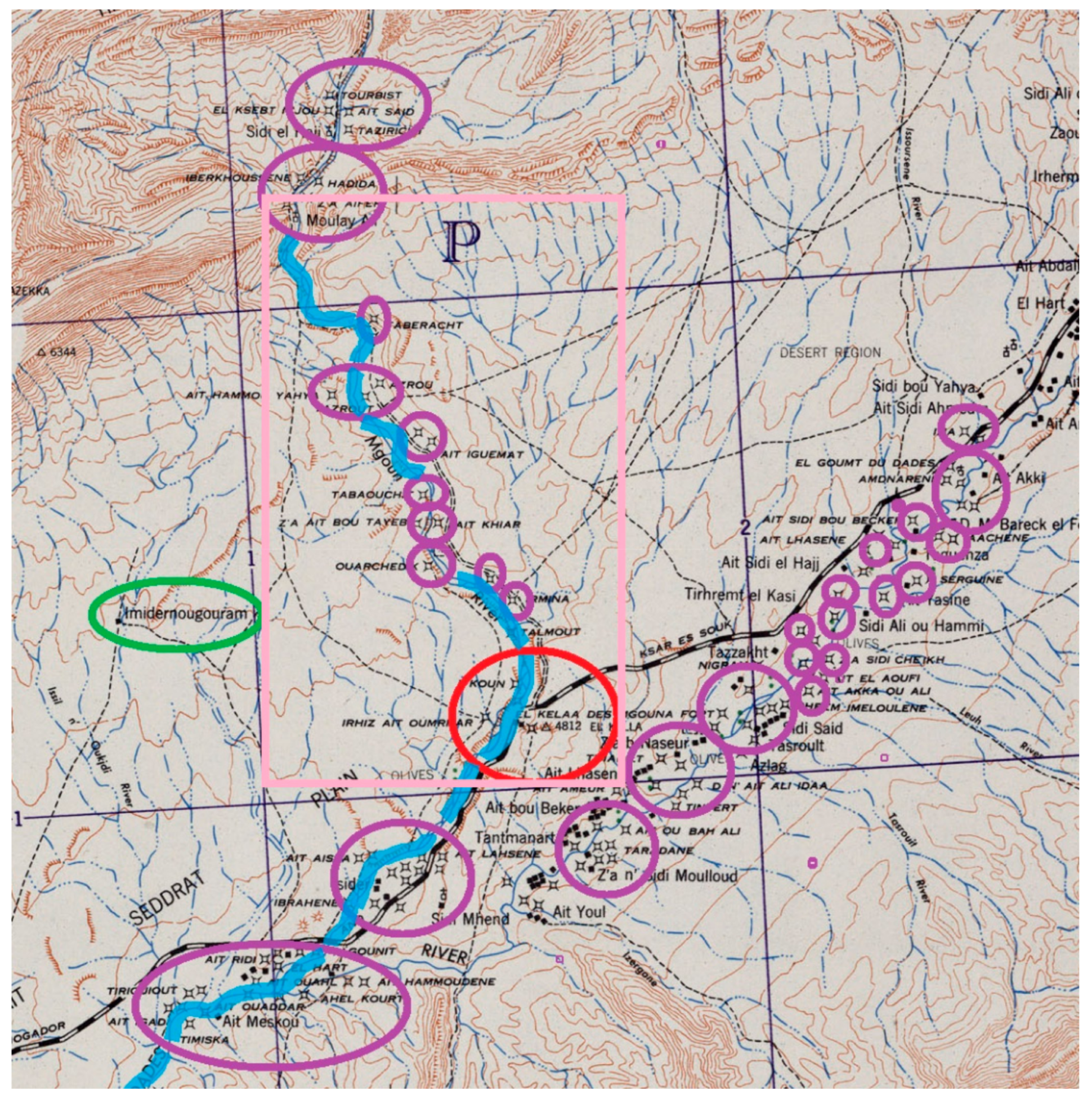
3. The Case Study: “The Roses Valley”

There is no lack of existing literature that consider the analysed area from landscape and social–economic perspectives [10]. The area is much studied [11] and was the subject, along with the entire province, of plans and programmes issued by the Moroccan Government [12] that attempted to revive the fortunes of a particularly peripheral region with little economic activity [13].

3.1. The Ribbon Oases

The study area is part of one of the largest and most important UNESCO Man and Biosphere (MaB) reserves in Africa—the ‘Oasis du Sud Marocain’3—which extends over a sizeable area of approximately 7 million hectares (Table 1), where there is a wide range of bioclimatic zones, such as the Mediterranean wetlands and the hyper-arid Sahara.4
The Reserve is the main place of endemism in North Africa, as well as hosting the majority of Moroccan species, such as 63% of birds, 60% of reptiles and 66% of mammals present in the country. Its highly effective oasis system protects the land from desertification and nurtures a very rich biodiversity. A skillful combination of crop-based production systems and sheep and goat breeding ensures high prolificacy, even in difficult environments. The cultivation systems practised are generally organised in three layers (date palm, fruit trees and crops below) or, in some cases, only in two layers, without the date palm. Ecologically, the oases are threatened by salinity and siltation. These forms of degradation are exacerbated by the harshness of the climate, water scarcity, a lack of control over irrigation, the grazing of spontaneous vegetation and the excessive removal of woody vegetation in pastoral areas.
Over the years, the oases were subjected to increasingly severe droughts and affected by bayoud disease,5 as well as strong migration flows. The combined action of all of these factors gradually transformed a natural area into a heavily anthropised zone. Date palms also form the basic agronomic structure of Moroccan oases, in particular by creating a microclimate that is indispensable for the good development of crops growing at the below level. All of these crops condition the economy of the oases and the stability of the populations living there. Date palm cultivation, which constitutes one of the main agricultural economies in the area, occupied a large area for a long time, though the area occupied by palm groves has shrunk considerably since the beginning of the century. A Ministry of Agriculture study [14] details the regional distribution of the national phoenicultural heritage, highlighting its concentration in three main areas: Ouarzazate (41%), Tafilalet (28%) and Skoura (20%). The problem of siltation has become a threat and, since the 1970s, has also progressively endangered homes, farmland, irrigation canals and road infrastructure in palm groves. These worrying events, combined with the poor economic diversification of the oases, pose a serious threat to these areas, a threat that risks generating long-term exclusion problems in these areas of strong identity-based and geostrategic importance for Morocco.
In this context, the “Roses Valley” is part of a millenary historical system that is a fragment of the caravan routes that both crossed the area studied longitudinally north–south and transversely west–east. The north–south axis connected the Mediterranean with the city of Timbuktu [15] in Mali,6 while the west–east transverse axis connected the Atlantic and all of the coastal centres with the Arabian Peninsula, which is the site of Mecca and the main centre of pilgrimage for Muslims. Over the centuries, along these caravan routes, many Berber tribes, through skillful use of the scarce water resources, along the Ouedas created a continuous set of oases that follow one another, forming a ‘ribbon’ to make it possible, in a suitable habitat for permanent settlement. This succession of oases forms a narrow band of varying size, never exceeding 10 kilometres, but winding for hundreds of miles, along which the Berber tribes settled. In part of this ribbon system, two valleys along the Dadès and M’Gouna oases show the conspicuous presence of rows of Damascene roses and a considerable number of kasbah, ksour and granaries that constitute a material heritage of considerable historical, architectural, landscape, urban and environmental interest.

3.2. The Kelaat M’Gouna Urban Area

The nearest population centres to the area are Agadir, which is an important port on the southern coast of Morocco, and Marrakesh, which is a famous southern Moroccan city with a history as a capital. The connection between Marrakesh and Kelaat M’Gouna is via national road No. 10, which crosses the “Tizi ‘n Tichka pass” (at an altitude of 2260 m). The M’Gouna Valley, known as the ‘Valley of Roses’, is about 30 kilometres long and stretches at the foot of the Ighil M’Goun massif in the middle of the central High Atlas mountain range, which reaches altitudes of over four thousand metres (4071 m). The main centre of the area is Kelaat M’Gouna, which rises at the confluence of the Dadès and the ouadi Asif M’Goun. It is only a few kilometres, about 20, away from the other centre of interest for the roses: Boumalne Dadès. Kelaat M’Gouna is a town in the province of Tinghir Drâa–Tafilalet [16,17]. Like the major cities of southern Morocco, it is made up of several neighbourhoods, forming a polynuclear settlement that administratively gravitates around a more densely urbanised central area. In particular, the central part of the city is formed of the following districts: Ait Aissi, R’kon, Elkelaa, Zawiyt nAguerd, Ait Baamran, Hay Annahda, Ait Boubker, Mirna and Taltnamart. Moreover, not physically distant from the central area are many douars (rural villages) that surround the town but are not administratively part of the municipality of Kelaat M’Gouna (Figure 1).
These villages include Aït Sidi Boubker, Ifri, Zawiyt Elbir, Amdnagh, Sarghin, Timskelt, Ait Boukidour, Tazzakht, Tawrirt and Tasswit. School facilities are also located in the central part of the city. In addition to primary schools, there are three high schools: Al Woroud (Roses), which is named after the roses of the Dades Valley, M’gGun and an Moulay Baamrane. There are two main souk (market) days in this city: Tuesdays involve the livestock trade, and Wednesdays involve the sale of food and other goods. Regardig secondary activities, there is a factory for the distillation of roses and the production of rose water (eau de rose), essential oils and cosmetic products. The route through the valley is dotted with traditional adobe kasbah that, once renovated, are available as small hotels along the road between Kelaat M’Gouna and Bou Thrarar. Due to its particularly lively nature, Kelaat M’Gouna is a very important economic and social centre for the entire region. According to the most recent ‘Recensement Général de la Population et de l’Habitat (RGPH)’ study, which dates back to 2014, the urban area has a population of 16,956. The old part of the city is also characterised by typical constructions in pisé, i.e., the traditional technique of southern Morocco, with kasbah being of particular architectural interest as they constitute one of the most important elements on which to focus this programme, as well as to plan and manage a sustainable development of the territory in a touristic key. In this direction, there are a number of good practices already implemented in the Dades and Draa valleys, where a considerable number of “land architectures” of historical and environmental interest are concentrated [18,19,20,21], from which we can draw ideas and methods that were previously successfully tested.

3.3. The Roses Garden of Kelaat M’Gouna

The cultivation of roses is spread over two areas: the first areas begins about 10 km from the village of Kelaat M’Gouna and extends for 10 km, ending near Boumalne Dades, while the second cultivation area begins in Kelaat M’Gouna and continues along a provincial road that climbs northwards, ultimately reaching the village of Bou Tharar, representing about 30 uninterrupted kilometres of rose gardens along the edges of the ouadi. The inhabitants practice subsistence farming in these locations, using small plots of land, that is based mainly on the cultivation of wheat, alfalfa for livestock and fruit trees. Birch trees are also planted, which are used as construction timber. These plots of land are watered by many irrigation canals. All strips of land are bordered by hedges of wild Damask roses, specifically of the botanical species ‘Rosa damascena’, which provide excellent protection from ruminants; thus, without the rose hedges, ruminants could ruin the cultivated fields. One of the first functions given to rose bushes by the Berbers was creating a separation barrier more than two metres high (a height sufficient to prevent goats from eating crops) between plots of land.
It was in the 1930s that the French realised the commercial value of these fragrant flowers and specifically started to cultivate them. To obtain the best olfactory yield, the rose petals are harvested in the absence of sunlight, i.e. at sunrise or sunset. After sorting, the rose buds are dried for two days on the earthen roofs of the kasbah. The very dry climate, which is characteristic of these altitudes, allows for excellent drying of the flowers. The cultivation of roses, together with other activities in the area, is of great importance to the local populations, since even if it is seasonal and not adequately paid, it constitutes one of their main sources of income. Cultivation takes place around the city of M’Gouna, while 30% of the processing of roses into finished and derived products takes place in Kelaat M’Gouna, Marrakech, Casablanca and Fez.

4. Results and Discussion

The territorial approach pursued in the study of the Valley of Roses highlighted the issues related to the development model pursued so far in this area. The latter model is essentially based, on one hand, on the desire to relaunch and promote ‘inland tourism’ that is linked to the richness of the landscape and cultural heritage and, on the other hand, on the production and processing of roses. These types of tourism, being valorised as local identity products (and as such labelled PDO-Protected Designation of Origin in 2014), are considered capable of acting as a flywheel in the complex articulation of the relationship between the dynamics of the production process and the relaunch of rural tourism in the area. In this regard, however, the SWOT analysis (Table 2) conducted on the potentialities and limitations detected in the area allowed a better definition of these scenarios; these definitions are useful for the elaboration not only of the initial diagnosis, but also, in particular, of sustainable development projects that are more in line with the needs of the territory and the communities living there.
More specifically, reflecting on the link between the development of rural tourism and the valorization of rose products, one element that emerged from the survey is the lack of co-ordination between the stakeholders involved at various levels (local, regional, national) in the two key sectors of the local economy (tourism and roses). Tourism remains a priority, as does the need for better economic structuring of the rose chain, in particular at the level of the marketing derived products, such as essential rose oil that is destined for the foreign market and, therefore, has a strong added value. In this regard, the New Model of Development (NMD),7 which was recently promoted by the government, suggests strengthening integration and territorial dynamics using the financial, human and natural resources available in the area. In particular, it aims to develop new ways of governing the territory in favor of State–Region complementarity, the development of integrated economic ecosystems, the valorization of living space and the conservation of natural resources [23].

5. Conclusions

The scenario identified in order to compose a framework of possible interventions in the area was intended to balance the potential and needs for valorizations in both the ‘rose route’ and ‘kasbah’ route tourist basins and create a model of sustainable balance for areas with particularly harsh climates for human beings [24]. It is a model that was proposed precisely to create a contrast with those more recurrent and in vogue in recent decades in the Arab world, particularly in the Arabian Peninsula (Dubai, Kuwait, etc.), where the relationship between man and nature is being irreparably devastated.
The Valley of Roses’ natural and cultural capital offers strong potential for the national and international tourism sector, particularly cultural tourism or wellness tourism, alongside niches in sports tourism and eco-tourism. Its diversified natural capital, its historical and cultural heritage, the hospitality of its population, its culinary expertise and its safe and secure environment are all assets that make it a popular tourist destination. Proximity, particularly to a European market that will be increasingly sensitive to the environmental impacts of and low-carbon footprint travel, further strengthens its potential. However, in line with the recommendations of the “New Development Model”, to fully harness this potential, it is necessary to develop a diversified tourism offer that highlights the country’s cultural and heritage assets and promotes them fully in all territories, as well as enhancing tourist entertainment. To achieve these objectives, close co-ordination among all sectors involved is necessary, in particular agriculture (for eco-tourism, gites, natural parks), culture (for the enhancement of tangible and intangible heritage), health (for wellness tourism) and sport (for activities with a high potential for exposure, such as surfing, mountaineering, etc.). This viewpoint calls for a systemic and partner-based approach, which embraces the growing complexity and interdependence of issues and decompartmentalizes the barriers to allow all potential to be unleashed through co-construction. This systemic approach necessarily entails the acceptance of a new mode of governance, setting up the conditions for cross-functionality and co-ordination (information sharing, multi-stakeholder implementation bodies, etc.). In this regard, one of the methodological trajectories to be pursued next is backcasting (especially participatory backcasting, with broad stakeholder involvement), which is an innovative planning methodology that gained ground in recent years, particularly in sustainability studies, but whose use as a strategic tool to arrive at a shared local development project is yet to be sufficiently tested. In contrast to forecasting scenarios, the main characteristic of backcasting scenarios is that they do not deal with forecasts of how the future might evolve, but focus on the definition of a desirable future and the development of strategies required to achieve it. This methodology requires backcasting from the end point to the current situation, making it possible to determine the feasibility of that future and the definition of what is needed to achieve the set goals. In particular, as stated by Robinson [25], backcasting aims to suggest the implications of different future situations, which are not chosen based on their probability, but based on other criteria, such as social or environmental desirability criteria, and emphasises the importance of a clear relationship between goal setting and planning. Ultimately, backcasting studies concern social interaction processes involving various stakeholders; thus, the pluralistic character of a society cannot be overlooked. The results of such studies also highlight the advantage of fostering a social learning process, precisely because of the interaction between the different subjects involved, who may change their views in this process of exchange with others to develop a shared vision and actions. Participation also makes it possible to give a voice to all citizens and make them responsible for the projects that affect them, thus fostering their success. In the light of these reflections, therefore, the continuation of this line of research envisages the use of participatory backcasting to support the elaboration, by local actors, of a systemic and shared sustainable development vision.

Author Contributions

Conceptualization, A.B., I.C. and T.V.; methodology, A.B., I.C. and T.V.; formal analysis, A.B., I.C. and T.V.; writing original draft preparation, A.B., I.C. and T.V.; writing review and editing, A.B., I.C. and T.V. All authors have read and agreed to the published version of the manuscript.

Funding

This research received no external funding.

Informed Consent Statement

Not applicable.

Data Availability Statement

Some or all data, models or code that support the findings of this study are available from the corresponding author upon reasonable request.

Acknowledgments

Paolo Pironti (CNR-ISMed).

Conflicts of Interest

The authors declare no conflict of interest.

Notes

1.
The Biosphere Reserve ‘Oasis du Sud Marocain was designated in 2000. It has rich agronomic diversity, including vast areas with date palms, acacia forests and other high-altitude forests covered with Juniperus thurifera, J. phoenicea and Quercus rotundiforia, among other species. In particular, the area is home to dorcas gazelles, gazelles de cuvier (Gazella cuvieri), barbarian sheep (Ammotragus lervia), ubara otards (Chlamydotis undelata) and cobras (Naja haje). The population of the Oasis du Sud Marocain has lived in this area for thousands of years. Most of their economic activities come from agriculture, particularly the production of cereals, potatoes, olives and, above all, dates, which are the backbone of the local economy. Recently, the cultivation and processing of new products, such as apples, roses and henna, significantly increased the farmers’ incomes.
2.
Project “Moroccan migration to Italy in time of global economic crisis” in partnership with Moulay Ismail University, Department of Sociology, Faculty of Arts and Humanities, Meknes, Morocco on the basis of the Bilateral Agreement for Scientific and Technological Cooperation CNR-Italy/CNRST-Morocco 2012–2013.
3.
4.
The region is classified by UNESCO as being part of the Biosphere Reserve of the Southern Moroccan Oases ReBOSuM. The ecological, environmental and socio-economic importance of the region faces several challenges, as anthropogenic impacts on the oasis ecosystem are changing the trajectory of ecosystem services.
5.
Bayoud disease is an epiphytic fungal disease of date palms. The disease was first reported in Morocco in 1870. The term ‘bayoud’ is derived from the Arabic abiadh (‘white’) and refers to the whitish colouring of diseased fronds.
6.
Timbuctu (Tumbuktu), originating as a cultural centre, became a trading centre in the 15th century. Caravan routes connected it to Sudan, Egypt, Tunis and Morocco. It cultivated trade relations with Italy and, in particular, with Florence.
7.

References

  1. Royaume du Maroc, Haut-Commissariat au Plan, Direction Régionale de Draa Tafilalet. Monographie Régionale 2021, La région Draa Tafilalet. Available online: https://www.hcp.ma/draa-tafilalet/docs/monographies/Monographie%20Regionale%20de%20l%27%27annee%202021.pdf (accessed on 28 April 2023).
  2. Salem, A.B. Changements Climatiques Dans les Oasis de Tafilalet Sud Est du Maroc; Editions Universitaires Européennes: Sarrebruck, Germany, 2016. [Google Scholar]
  3. Kuisma, J.; Haanpera, H. Water quality pressures and water management. In Encounters across the Atlas: Fieldtrip in Morocco 2011; Minoia, P., Kaakinen, I., Eds.; Unigrafia: Helsinki, Finland, 2012; pp. 58–71. Available online: https://helda.helsinki.fi/handle/10138/37939 (accessed on 28 April 2023).
  4. Bertini, A.; Caruso, I.; Cuturi, C.; Vitolo, T. Preserving and valorising the settlement system of South Morocco. In Proceedings of the 6th International Conference on Heritage and Sustainable Development, Granada, Spain, 12–15 June 2018; pp. 1895–1906. [Google Scholar]
  5. Bertini, A. Sviluppo sostenibile nel Sud del Marocco. In Percorsi Migranti; Bruno, G.C., Caruso, I., Sanna, M., Vellecco, I., Eds.; McGraw-Hill: Milano, Italy, 2011; pp. 143–160. ISBN 978-88-386-7296-5. [Google Scholar]
  6. Caruso, I.; Vitolo, T.; Bertini, A. Cultural heritage and territorial development: A comparative analysis between Italy and Morocco. In Proceedings of the 6th International Conference on Heritage and Sustainable Development, Granada, Spain, 12–15 June 2018; pp. 719–730. [Google Scholar]
  7. Troin, J.F.; Berriane, M.; Guitouni, A.; Laouina, A.; Kaioua, A. Maroc: Régions, Pays, Territoires; Maisonneuve et Larose: Paris, France, 2002. [Google Scholar]
  8. Camagni, R. Territorial capital and regional development. In Handbook of Regional Growth and Development Theories; Capello, R., Nijkamp, P., Eds.; Edward Elgar: Cheltenham, UK, 2009; pp. 118–132. [Google Scholar]
  9. Lacquement, G.; Chevalier, P. Capital territorial et développement des territoires locaux, enjeux théoriques et méthodologiques de la transposition d’un concept de l’économie territoriale à l’analyse géographique. Ann. De Géographie 2016, 5, 490–518. [Google Scholar] [CrossRef]
  10. Berriane, M. Dynamiques Territoriales et Politiques Publiques: Territoires Fonctionnels et Territoires Officiels In Le Maroc au Présent: D’une Époque à L’Autre, une Société en Mutation; Dupret, B., Rhani, Z., Boutaleb, A., Ferrié, J.-N., Eds.; Centre Jacques-Berque: Casablanca, Morocco, 2015; Available online: http://books.openedition.org/cjb/998 (accessed on 26 April 2023).
  11. Michon, G.; Berriane, M.; Aderghal, M.; Landel, P.-A.; Medina, L.; Stephane, G. Construction d’une destination touristique d’arrière-pays: La « Vallée des roses » (Maroc). GÉOgraphie Et DÉVeloppement Au Maroc. 2018, 5, 1–13. [Google Scholar]
  12. Sadki, A. Environnement, paysage et projet de territoire. Vers une approche territoriale pour la sauvegarde et la mise en valeur de la réserve de biosphère des oasis du sud marocain. Master’s Thesis, Université Senghor, Alexandrie, Egypt, 2007. [Google Scholar] [CrossRef]
  13. Boulanouar, B.; Kradi, C. Actes du Symposium International Sur: Le developpement Durable des Systemes Oasiens; Institut National de la Recherche Agronomiqu: Erfoud, Morocco, 2005; Available online: https://www.inra.org.ma/sites/default/files/publications/ouvrages/oasis.pdf (accessed on 3 May 2023).
  14. Office Régionaux de la Mise en Valeur dé l’Agricol, OMRVA 2019. Available online: https://www.ormvatafilalet.ma/ (accessed on 2 May 2023).
  15. Hammer, J. La biblioteca segreta di Timbuctù. In La Vera Storia Degli Uomini Che Salvarono Trecentomila Libri Dalla Furia Della Jihad; Rizzoli: Milan, Italy, 2017. [Google Scholar]
  16. Sadki, A. Urbanisme et Dégradation de L’Habitat Traditionnel des Oasis du Sud-Est Marocain: L’Exemple des Ksour du Tafilalet (Province d’Errachidia). Available online: http://www.archi-mag.com/essai_18.php (accessed on 5 May 2023).
  17. Sadiki, M.; Essami, A.; Bouaouinate, A. Les ksour du Tafilalet: Un patrimoine culturel et touristique en déclin. J. Political. Orbits 2019, 3, 76–94. [Google Scholar]
  18. Boussalh, M.; Cancino, C.; Marcus, B.; Wong, L. The development of a conservation and rehabilitation plan (CRP) for the earthen Kasbah of Taourirt in southern Morocco. J. Mater. Environ. Sci. 2016, 7, 3579–3583. [Google Scholar]
  19. Ginex, G. Un sistema interattivo per la conoscenza e la gestione del patrimonio culturale in area mediterranea. La Kasbah di Ait Ben Haddou, un progetto di rappresentazione, (Cultural heritage Documentation. The Kasbah of Ait Ben Haddou in Morocco). Disegnare Con 2010, 64–76. [Google Scholar] [CrossRef]
  20. Kagermeier, A.; Amzil, L.; Elfasskoui, B. Touristification of the Moroccan Oasis Landscape: New Dimensions, New Approaches, New Stakeholders and New Consumer Formulas. Available online: https://www.academia.edu/37245318/Touristification_of_the_Moroccan_oasis_landscape_new_dimensions_new_approaches_new_stakeholders_and_new_consumer_formulas (accessed on 4 May 2023).
  21. Cancino, C.; Marcus, B.; Boussalh, M. Conservation and Rehabititation Plan for Tighermt (Kasbah) Taourirt, Southern Morocco; The getty Conservation Institues, Los Angees, Centre de Conservation et de rehabilitation du Patrimoine Architectural atlasique et subatlasique (CERKAS): Ouarzazate, Morocco, 2016; pp. 1–400. [Google Scholar]
  22. World Heritage Earthen Architecture Programme (WHEAP). Available online: https://whc.unesco.org/en/earthen-architecture (accessed on 1 May 2023).
  23. Bertini, A.; Caruso, I.; Vitolo, T. Inland Areas, Protected Natural Areas and Sustainable Development. Eng. Proc. 2022, 18, 20. [Google Scholar] [CrossRef]
  24. Dale, R. Lightfoot, Moroccan Khettara: Traditional Irrigation and Progressive Desiccation. Geoforum 1996, 27, 261–273. [Google Scholar]
  25. Robinson, J.B. Futures under glass: A recipe for people who hate to predict. Futures 1990, 22, 820–842. [Google Scholar] [CrossRef]
Figure 1. Map of Valley of Roses. Legend: pink square locates the Valley of Roses; the red circle highlights centre of Kelaat M’Gouna, purple circles highlight the kasbah; green oval highlights granary; light blue line locates course of Dades river (Cartographic base: Army Map Service U.S. Army, Washington D.C., 1943, Southern Morocco 1: 125,000 Aine Toumert sheet; cartographic elaboration performed by Antonio Bertini).
Engproc 39 00008 g001
Table 1. Zoning and dimensions of UNESCO Mab site ‘Oasis de Sud Marocain’, designated in 2000. Source: MaB UNESCO ‘Oasis de Sud Marocain’.
Map Surface haCore Area(s) haBuffer Zone(s) haTransition Zone(s) ha
7,185,371908,5814,619,2301,657,560
Table 2. Swot Analysis of Valley of Roses.
StrengthsWeaknesses
Biosphere Reserve
Raw earth constructions, i.e., kasbah, igherem and entire neighbourhoods (ksars)
Local handicrafts
Tourist equipment
Rural tourism
Rose picking
Rose processing
Rose processing techniques
Identity and typical landscape in the area
Climatic conditions suitable for diversifying tourism
Distance from the polluted urban environment
Healthy environment
Well-maintained oases
Date production
Wrought iron craftsmanship
Identity-based production—mantice
Identity-based production—rural ceramics
Identity-based production—Weaving
Identity-based production—shoemaking
Identity-based production—daggers (typical of and exclusive to Kelaat M’Gouna)
Kettara in desiccation
Peripherals
Reduced agricultural production and date production
Few economic activities
Low employment rates in general, and high youth employment in particular
Low attractiveness for residents
Low attractiveness for tourists and travellers
Most economic activities and, to a large extent, those related to the tourism industry are in the hands of external companies, which have little involvement in local communities
Income from tourism activities contributes little to improving the living standards of local communities
A lack of ecological education that can make people understand that the old way of life is better than the contemporary one
Innovative and non-traditional techniques are problematic because they do not use natural products that stem from the production of rose by-products
The world’s largest solar power plant located just 10 km from Ouarzazate, inaugurated in 2016, does not power the Draa Tafilalet region
Opportunities
World Heritage Earthen Architecture Programme (WHEAP) [22]
Federation Interprofessionelle Marocainede la Rose a Parfume
New Development Model (NMD)
New Action Plan for the tourism sector for the period 2023–2026 with an allocation of 6.1 billion Moroccan dinars (the tourism sector has a new action plan, with a new strategic roadmap for the period 2023–2026. More than DH 6.1 billion will be allocated to the implementation of this roadmap. For the implementation of this roadmap is scheduled to take 4 years. The plan aims to attract 17.5 million tourists in 2026, after reaching 11 million last year. The plan has multipe specific aims: (1) to reach USD 120 billion in foreign exchange earnings; and (2) to create 200,000 new direct and indirect jobs by 2026. To achieve these objectives, the sector will have to achieve the following aims: (a) creating a new diversified structure of the tourism offer; (b) strengthening air connections; (c) supporting and promoting e-marketing; (d) diversifying the cultural and free-time offers; (e) redeveloping the existing hotel heritage and creating new hotel facilities; (f) strengthening human capital via an attractive training framework (Joint Note No. 42-INAC-HCP—April 2023).)
Développement Rural et des Eaux et Forêts à la zone d’action de ORMVA Tafilalet, 2020
Threats
Architectural and natural heritage under threat
Desertification
Drying out of khettara irrigation systems
Palm disease (BAYARD)
Migration processes of local populations
Falsification in the production of rose derivatives
Lack of brand protection for the processing and production chains of rose derivatives
Source: own elaboration.
Disclaimer/Publisher’s Note: The statements, opinions and data contained in all publications are solely those of the individual author(s) and contributor(s) and not of MDPI and/or the editor(s). MDPI and/or the editor(s) disclaim responsibility for any injury to people or property resulting from any ideas, methods, instructions or products referred to in the content.

