Proceeding Paper

Advancement of a Pavement Management System (PMS) for the Efficient Management of National Highways in Korea †

1
Korea Institute of Civil Engineering and Building Technology, 283, Goyang-daero, Ilsanseo-gu, Goyang-si 10223, Republic of Korea
2
Ministry of Land, Infrastructure and Transport, 11 Doum 6-ro, Government Complex-Sejong, Sejong City 30103, Republic of Korea
*
Author to whom correspondence should be addressed.
Presented at the Second International Conference on Maintenance and Rehabilitation of Constructed Infrastructure Facilities, Honolulu, HI, USA, 16–19 August 2023.
Eng. Proc. 2023, 36(1), 67; https://doi.org/10.3390/engproc2023036067
Published: 26 September 2023

Abstract

:
In order to maintain a suitable road pavement level with limited resources, a management system must be established. In order to achieve this goal, a program using AI (artificial intelligence) was developed to manage and evaluate a sizable volume of survey data. A national highway pavement data management system (PDMS) built on the WEB was also constructed. By connecting several artificial neural networks, the AI crack analysis algorithm was created and taught to automatically recognize cracks in road photos and calculate crack rates. In the PDMS, the current condition of a national highway can be shown on a map, and all the data are updated to allow for verification in increments of 100 m for each lane. The system was also improved to enable the collection of information on the detailed survey section’s pavement repair specifics according to survey year.

1. Introduction

Korea is facing budget constraints as the length of managed roads continues to grow. As a result, with limited resources, a system that can maintain road pavement conditions at an appropriate level or higher is required. To this end, a Road Pavement Management System (PMS) was developed to efficiently manage road pavements in a timely and effective manner [1]. Previously, investigations were conducted on road sections, as requested by the Land Management Office. Since 2022, the crack rate, plastic deformation, and longitudinal smoothness of 38,000 km/lane of the national road has been investigated [2]. Due to the increased data generated through this complete inspection, crack analysis performed by existing personnel is ineffective. As an alternative to this, a study on the introduction of an AI crack analysis program was conducted. Furthermore, a study was conducted to advance the pavement data management system (PDMS) for general national highways so as to efficiently manage pavement condition surveys and maintenance performance data.

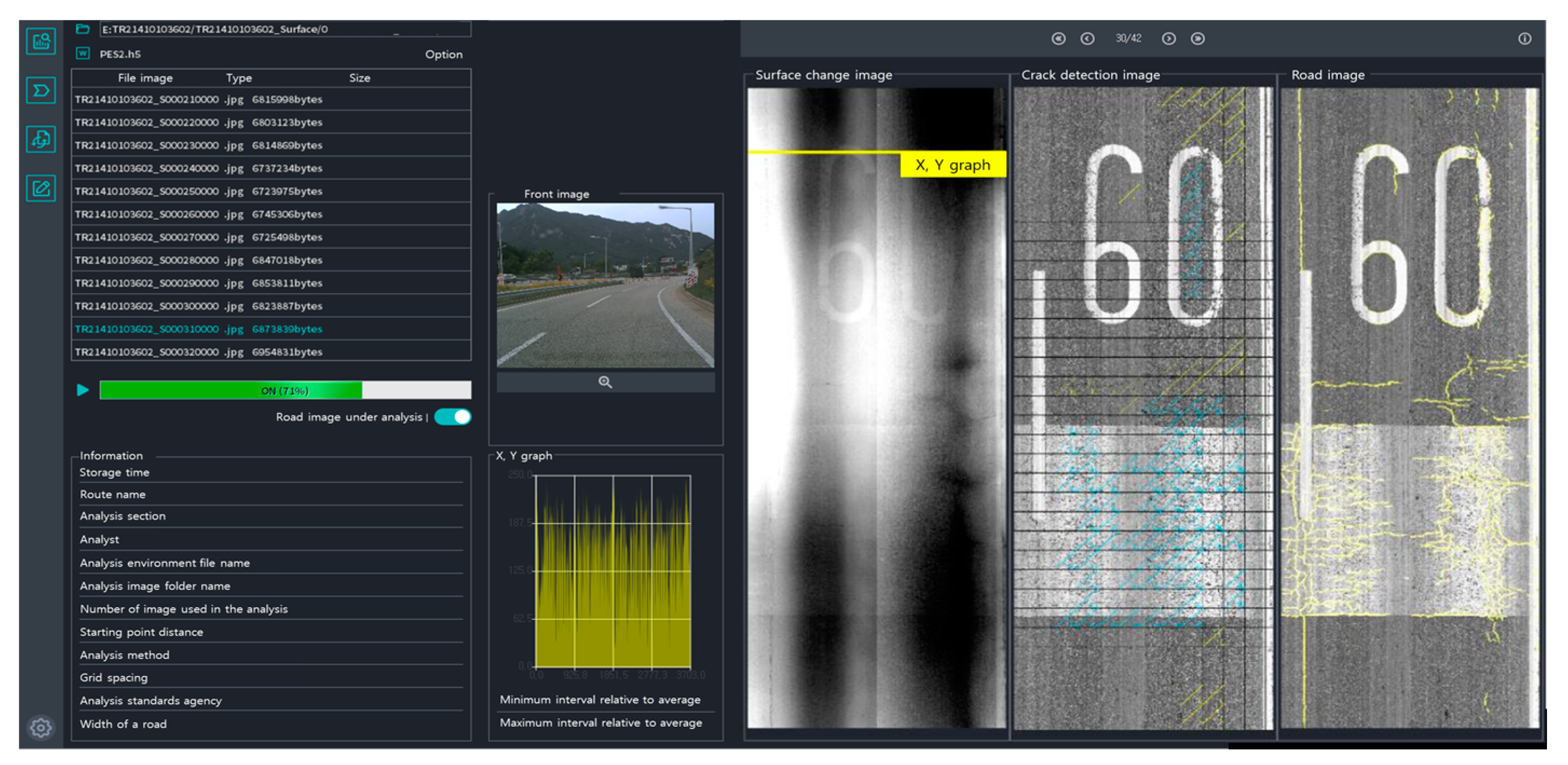
2. Road Pavement AI Analysis Program

2.1. Program Structure

The developed crack analysis program’s artificial intelligence model was designed by combining the crack area detection and classification models. The crack area detection model identifies the cracked area in the road image and binarizes the cracked and non-cracked areas into 0 and 1, respectively. Following that, the crack classification model categorizes the cracks into linear cracks, turtle cracks, and so on. The two models are combined to create a database that can be used to determine the types and risk of cracks.

2.2. Artificial Intelligence Learning Process

By segmenting images and analyzing specifically processed data, additional UNET++ artificial intelligence research was carried out to enhance the functionality of the current experimental crack analysis application. Data scaling and data rotation were performed in an amplification process, along with the learning data.

2.3. Automation of Road Crack Analysis Program

The previously examined road image must be loaded before the program automatically analyzes the road for the automation of crack analysis software. Therefore, a system was created using the automation tool so that the software could trace the path from the folder selected as the road survey image, import the image, and then automatically link and present the analysis results. The program's user interface during automatic analysis is shown in Figure 1.

3. Advanced National Road Pavement Data Management System (PDMS)

3.1. Pdms Database Construction

The database was classified into the route condition management of general national roads, the pavement condition investigation area, the maintenance performance management area, and the general national road pavement condition investigation area. It was established in order to annually collect pavement, bridge, and tunnel condition information and traffic volume data for general national road pavement condition management.

3.2. PDMS Functional Configuration

The route status of general national roads was configured to manage each route's alignment and attribute information based on the geographic information system (GIS). General national road geographic information is used to manage data on the route numbers, road alignments, junctions, the start and end points of bridges and tunnels, and administrative districts for the 51 routes in the country [3]. Attribute information is configured to manage the management agencies, the number of lanes, pavement types, and pavement thickness information. Figure 2a shows the route status of the general national roads as process information and attribute information, respectively.
The general national road pavement condition survey is managed in relation with the data of each section, and the data management function is classified according to the characteristics of the surveying equipment. The PES (Pavement Evaluation Surveyor) takes pictures of the damage on the pavement surface in the survey section and investigates the plastic deformation and longitudinal flatness through sensing. In addition, pavement conditions such as cracks and pothole repairs are evaluated through the analysis system, and the results are uploaded to the PDMS for management.
The visualization function was enhanced, as shown in Figure 2a. As the pavement condition survey of general national roads has been operated as a complete enumeration survey system since 2021, the pavement condition survey and analysis data, regardless of the existing number of lanes, can be realistically verified for each lane.
As shown in Figure 2b, the survey data on the pavement conditions of general national roads across the country were managed by linking the survey area with GIS for the general national roads. For each survey spot, the pavement condition and other status-related information are classified and managed using the designated spot number. By choosing the survey part shown on the map, one is able to check the pavement condition state and other information on current status.

4. Pothole Information Management

4.1. Pothole Information Linkage

Two devices are in operation according to the Land Management Office, and they are mounted on vehicles to detect potholes in the operating section. The detected pothole data were linked to the road work management safety guard app through a related service. In addition, a system was established to link pothole information from among the work information managed by the Road Work Management Safety Keeper app to PDMS.

4.2. Pothole Status Map

The pothole status map is a function that visually provides pothole information using an electronic map, and it is divided into a pothole distribution map and a location map. The pothole status map is built to provide various manipulation tools such as style setting, inquiry options, map control, legend setting, and regional development according to the Land Management Office.
The pothole status map is divided into a pothole distribution map and a location map, as shown in Figure 3a. The pothole distribution map displays the number of potholes according to region as defined by the Land Management Office, with the color according to the legend. The pothole location map is implemented to display the locations of potholes on the electronic map.
The blue and orange dots indicate pothole locations on the status map. A blue dot is a pothole that has been repaired, and an orange dot is a pothole in the repair process. When a dot is selected by enlarging the pothole status map, the corresponding pothole information can immediately be checked on the electronic map. When the displayed pop-up of the pothole is clicked, a detailed information page of the corresponding pothole is requested. Figure 3b depicts the information-checking function for each pothole location.

5. Conclusions

In this study, research was conducted to develop a crack analysis program using road survey data, advance the pavement data management system, and establish a pothole information management system to efficiently address the increased management extension. As a result of the study, the following conclusions were obtained:
  • Objective crack analysis results were derived by developing a road pavement crack analysis program using AI. Its accuracy is improved using a designing that excluded anomalous objects on the road surface. In the future, this system’s accuracy could be improved by performing additional learning to exclude abnormal items such as manholes and expansion joints. Based on the derived results, an efficient maintenance management system based on consistent standards would be possible.
  • The system was enhanced so that the survey data and analysis results of paved general national roads can be checked in units of 100 m per lane using a map. In addition, improvements were made so that survey agencies, analysis agencies, and road management entities can be used to efficiently manage roads through the visualization of survey and analysis results, maintenance sections, and budgets using the advanced general national road pavement data management system. In the future, the usability of this system could be improved by upgrading the construction data upload function and the automatic budget allocation function.
  • The pothole information management function is used to monitor pothole occurrence and repair status for general national roads and establish a pothole status map and pothole list. The built pothole information management function makes it possible to take immediate action for potholes in general national roads. Furthermore, it would be possible to efficiently conduct pothole repair by analyzing pothole occurrence frequency per region.

Author Contributions

Conceptualization, M.L.; methodology, M.L. and H.Y.; validation, S.H. and M.K.; investigation, M.K. and H.Y.; writing-original draft preparation, S.H.; writing-review and editing, M.L., N.L. and C.K.; project administration, M.L. and N.L.; funding acquisition, M.L. and C.K. All authors have read and agreed to the published version of the manuscript.

Funding

This work was supported by consignment business 2023 Pavement Management System (PMS) by the Ministry of Land, Infrastructure and Transport (MOLIT).

Institutional Review Board Statement

Not applicable.

Informed Consent Statement

Not applicable.

Data Availability Statement

All data are new and experimented.

Conflicts of Interest

The authors declare no conflict of interest.

References

  1. Lim, J.K.; Lee, S.W.; Kim, Y.J.; Kim, B.G.; Sin, H.J. A Study of Improving Pavement Data Management System of National Highway. In Proceedings of the 2012 Fall Conference of Korea Information Processing Society, Jeju university, Jeju City, Republic of Korea, 22–23 November 2012; p. 1746. [Google Scholar]
  2. Framework Act on Sustainable Infrastructure Management. Republic of Korea, Act No. 17237. 7 April 2020.
  3. Lim, J.K. Development of Condition Change Prediction Model for Asphalt Pavement Using National Highway PMS Database. J. Korean Road Soc. 2021, 23, 105–106. [Google Scholar]
Figure 1. Automated analysis tool user interface.
Engproc 36 00067 g001
Figure 2. (a) Route status of general national roads (geographic information). (b) Management of pavement condition survey data.
Engproc 36 00067 g002
Figure 3. (a) Types of pothole status map. (b) Information verification function according to pothole location.
Engproc 36 00067 g003
Disclaimer/Publisher’s Note: The statements, opinions and data contained in all publications are solely those of the individual author(s) and contributor(s) and not of MDPI and/or the editor(s). MDPI and/or the editor(s) disclaim responsibility for any injury to people or property resulting from any ideas, methods, instructions or products referred to in the content.

