Proceeding Paper

Aircraft Go-Arounds Associated to Vessel Traffic: Hamburg Finkenwerder Case Study †

DLR Institute of Maintenance, Repair and Overhaul, Hein-Saß-Weg 22, 21129 Hamburg, Germany
*
Author to whom correspondence should be addressed.
Presented at the 10th OpenSky Symposium, Delft, The Netherlands, 10–11 November 2022.
Eng. Proc. 2022, 28(1), 5; https://doi.org/10.3390/engproc2022028005
Published: 15 December 2022
(This article belongs to the Proceedings of The 10th OpenSky Symposium)

Abstract

:
An aircraft go-around is a costly yet safety critical procedure. While there are many reasons to decide that a go-around is necessary, at Hamburg Finkenwerder airport (EDHI) there is a rather peculiar one: vessel traffic crossing the approach path. As both vessels and aircraft transmit their position at regular intervals through the Automatic Identification System (AIS) and Automatic Dependent Surveillance Broadcast (ADS-B) protocols it is possible to identify vessels that can cause problems to the aircraft’s approach. In this work we identified a 10 time higher than average go-around incidence at Finkenwerder airport and were able to find evidence of its relation to large passing vessels. As vessel traffic has a mostly stable course and speed, we found it is possible to predict the passing vessels well ahead of time in order to determine the best approach and reduce the number of go-arounds, allowing to save both fuel and emissions.
Keywords:
go-around; vessel; AIS; ADS-B

1. Introduction

An aircraft go-around or missed approach is the consequence of an abortion of the landing process due to a variety of causes such as wind gusts or the sudden appearance of hazardous obstacles [1]. Though this procedure is undertaken out of safety measures, it causes additional flight time and altitude variations. This consequently leads to detrimental environmental and economical effects due to increase of fuel consumption and its respective emissions, additional noise and additional air traffic management needs [2]. For airports located near a harbour a go-around may be caused by vessel traffic, as a large vessel can cross the aircraft’s path during the approach. This is, for example, the case for the North-East approach at Hamburg-Finkenwerder airport (EDHI), as can be seen in Figure 1. In order to efficiently manage traffic each means of transportation needs to communicate its presence to others. For aircraft this is achieved through the Automatic Dependent Surveillance Broadcast (ADS-B) protocol and the OpenSky network [3] makes the data obtained from these messages available to the public. Similarly for vessel traffic this information is transmitted through Automatic Identification System (AIS) transponders. In most cases these two domains are independent of each other, however, in this work we present a case study where combining these two domains could lead to more efficient air traffic handling. We proceed by describing ADS-B and AIS in more detail in the next Section 2. Subsequently, we determine the number of go-arounds at Finkenwerder airport in Section 3.1 and Section 4.1 and identify vessel traffic present during the approach of flights. We then consider the predictability of this event in Section 3.2, Section 4.2 and Section 4.3. Finally we discuss our findings and elaborate on the potential to optimise air traffic handling in Section 5.

2. ADS-B and AIS Protocols

Vessels and aircraft transmit their location respectively through the AIS and ADS-B protocols. ADS-B data include information regarding aircraft and their flight. For aircraft the identification, model, and airline are given. On the other hand each flight comprises its meta information such as its timing and estimated airports of arrival and destination, as well as its trajectory. The flight-related data that are used in this work include:
  • aircraft identification (International Civil Aviation Organization (ICAO) identifier)
  • timing of the flight (first seen and last seen)
  • estimate of departure and arrival airports
The trajectory on the other hand is transmitted by the aircraft during the flight and is mainly sampled at 1 Hz. From the data the following parameters are used:
  • latitude
  • longitude
  • altitude
  • heading
As the trajectory data can present some outliers and missing values, they are preprocessed before use. For the latitude, longitude, and altitude, outliers are removed using median filters and physical limits after which it is interpolated with linear interpolation.
Similar to ADS-B, the AIS protocol is used for vessels. According to the International Convention for the Safety of Life at Sea (SOLAS) regulation V / 19 , which is part of the regulatory framework developed and maintained by the International Maritime Organization (IMO), all vessels of 300 gross tonnage and upwards engaged on international voyages, cargo vessels of 500 gross tonnage and upwards not engaged on international voyages and passenger vessels irrespective of size are required to be fitted with an AIS transponder. AIS class A transponders transmit static, dynamic and voyage related information [4]. The static data include information on the vessel’s characteristics such as its identification number (Maritime Mobile Service Identity (MMSI)), type, and dimensions. The dynamic data describe the vessel’s movements and include information such as: position, speed, and course. Depending on speed and course alteration, the update rate of the dynamic information of vessels which are not moored or anchored ranges between 2–10 s. The voyage-related information includes the destination, route plans and draught [5]. Gross tonnage is a non-linear measure of a vessel’s overall internal volume. It does not include containers. Vessels which might be an obstacle for air traffic are well beyond this limit.
The AIS data used in this work include static and dynamic information. The static information used includes:
  • vessel identification (MMSI)
  • length
  • width
  • type
The dynamic information used includes:
  • vessel identification
  • latitude
  • longitude
  • speed
To be noted is that the height of vessels is not included in AIS messages. As such the other dimension values will be used to infer the vessel’s size.

3. Methods

3.1. Identification of Go-Arounds

To identify what flights had a go-around and at what time it occurred, a slight variation of the method proposed by Xu et al. [6] is used. The method consists of the following steps:
  • add flight phases to the trajectory using the flight data processor by Sun et al. [7]
  • in the second half of the flight and where the altitude is below the go-around threshold (3820 ft above airport altitude) the following phase transitions are trajectory identified in the trajectory:
    • Descent to Level
    • Descent to Climb
    • Level to Climb
  • analyse the 60 s following the transition, if the mean rate of climb is above 300 ft/min and 45% of the flight phases is climb, then the phase transition point constitutes a go-around point.
Compared to the original method by Xu et al. the rate of climb threshold was reduced from 700 ft/min to 300 ft/min as initial visual evaluation showed many false negatives. Furthermore, the consideration of only the second half of the flight for was added.
After the automated identification, a visual evaluation was also performed and results adjusted accordingly.

3.2. Identification of Vessels on Aircraft Path

For the association between vessel and air traffic we consider flights that with a North-East approach. For each flight we analyse the time frame from the first point of runway heading until 60 s after touchdown. For flights where a go-around occurred this time is estimated using the typical landing paths of other flights where no go-around occurred. The estimation is performed by adding the time of first runway heading until the go-around point and the maximum time it took a flight where no go-around occurred to fly from the point of go-around to 60 s after touchdown. All vessels that cross the longitudinal line of the runway in this time frame are associated with the flight in question.
To analyse the predictability of vessel traffic crossing the runway we implement a simple method comparing the location of the largest vessel crossing the runway respectively 5, 10, 20, and 30 min before it crosses the longitudinal line of the runway. Using the median speed of the respectively 2, 5, 10 and 20 min before it reached this point, we estimate how long it will take the vessel to cross flight path.

4. Results

For our results we look at flights with an estimated arrival at Hamburg Finkenwerder airport (EDHI) from the OpenSky network up to September 2022. In order to avoid test flights that may occur at this airport we consider flights with a callsign from one of the commercial airlines that fly or have flown to Finkenwerder:
  • Titan Airways (AWC)
  • Volotea (VOE)
  • Germania (GMI)
  • Airbus Transport International (BGA)
Table 1 shows the number of flights and go-arounds for each of these airlines.

4.1. Go-Around Occurrence

After the automated analysis, a visual inspection is performed on all flights which leads to the identification of three test flights, four false negatives and five false positives. The identified test flights are excluded from further analysis and the false positives and negatives adjusted.
Limited by the available AIS data, for the rest of our results we focus on the year 2019 where 1022 flights landed in Finkenwerder airport, of which 34 had at least 1 go-around. Table 2 shows how the proportion between North-East and South-West approaches varies between flights with and without go-around, while Figure 2 shows the distribution of flights with and without go-around over the year. For the identification of vessels on the aircraft’s path we focus on the North-East approach. Moreover, for flights with and without vessel traffic present, one can observe that the proportion varies between flights with and without go-around.
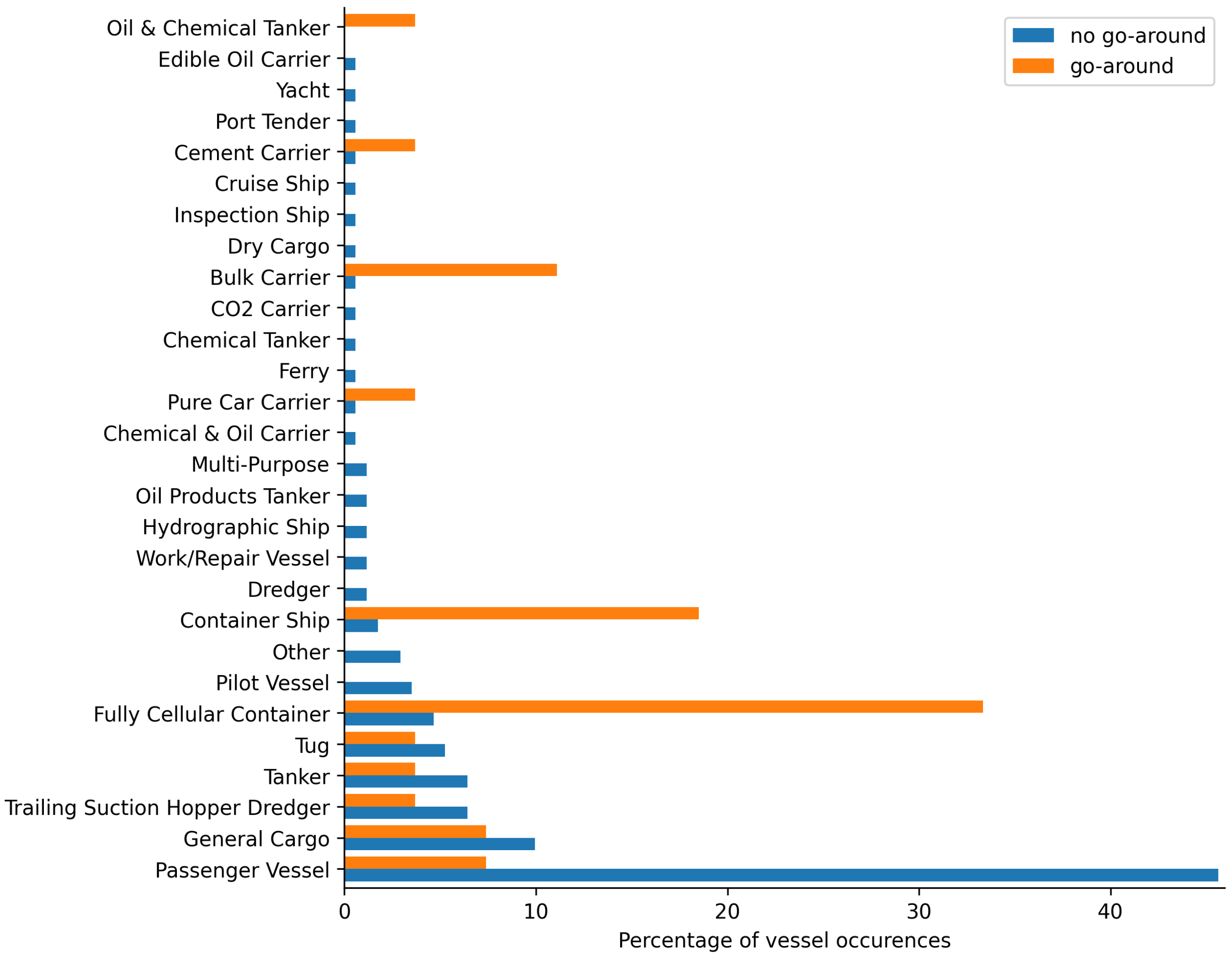
To further investigate the vessel traffic, we identify the largest passing vessel for each North-East approach where vessel traffic was present. It is worth noting that the height of the vessels, unfortunately, is not a parameter transmitted through AIS messages. Figure 3 shows the distribution of the largest passing vessel for flight with and without go-around. One can note that the types of vessels that occur during go-around are the typically large types of vessels, with the exception of tankers and tug boats. Passenger vessels at the Hamburg harbour are mostly the ferries, of which some routes cross the approach path, however some are also large cruise ships that could pose a problem to passing air traffic.

4.2. Vessel Traffic during Flights

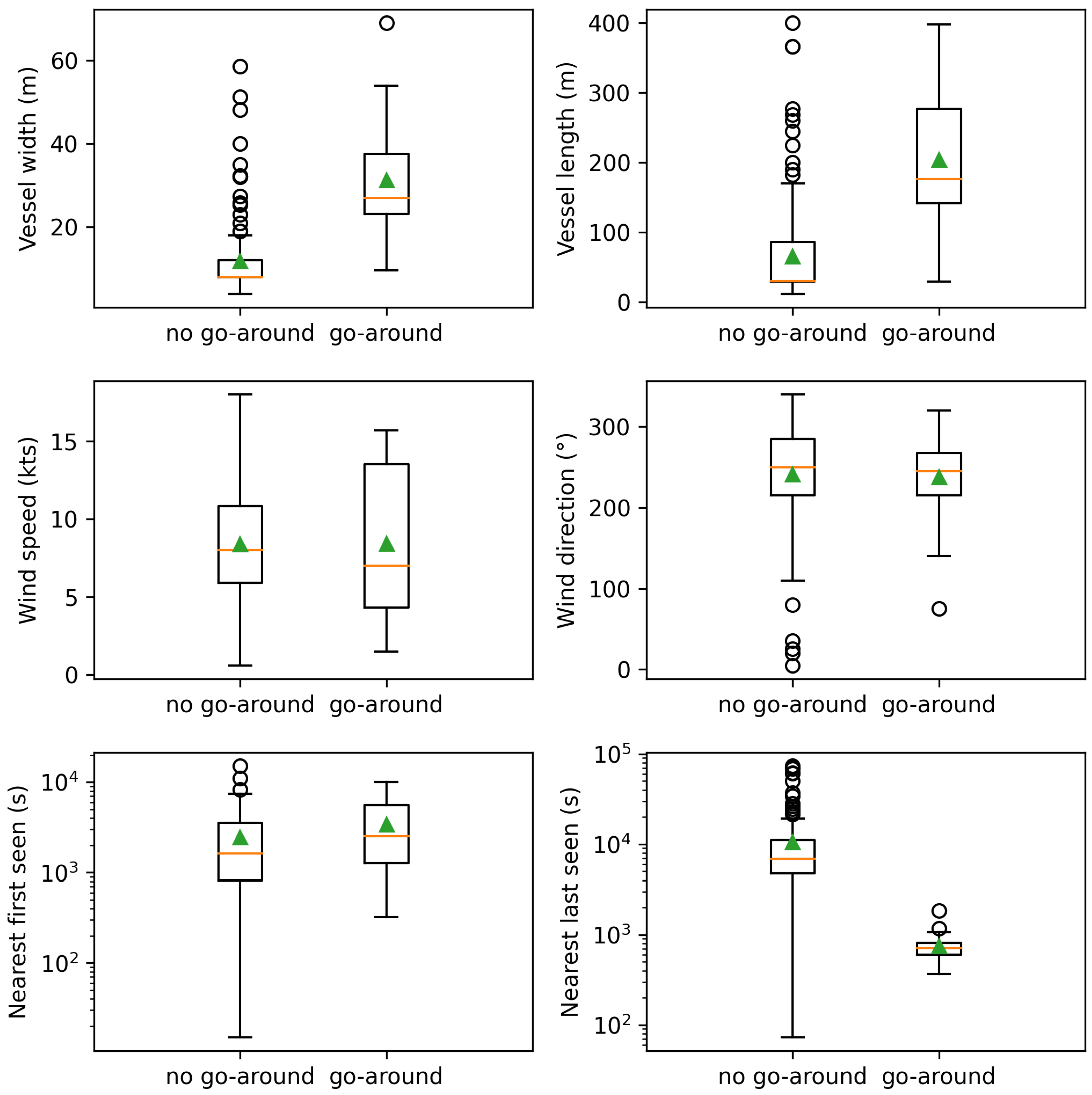
As can be seen in the top row of Figure 4, vessels passing during a go-around or missed approach are on average larger both in width (mean = 31.3 ) and length (mean = 204.3 ), compared to vessels passing during a regular approach (mean width = 11.7 , mean length = 65.2 ). In fact, the non-parametric Mann–Whitney U test [8] confirms that the distributions underlying the width and length of vessels passing during go-around are stochastically greater than the distributions underlying width (statistic = 4256, p-value = 4.6 × 10 13 ) and length (statistic = 4176, p-value = 6.5 × 10 12 ) of vessels passing during regular approaches. Using the Point Biserial Correlation [9], a correlation is found between the instances of a go-around and the dimensions of the vessels. Both the vessel length (correlation = 0.57 , p-value = 3.9 × 10 18 ) as well as the width (correlation = 0.59 , p-value = 1.0 × 10 21 ) show a moderate correlation with the occurrence of go-arounds.

4.3. Prediction of Vessel Traffic Near Runway

We analyse the predictability of the arrival of these large vessels that crossed the runway path during a go-around by comparing the error introduced in the estimated time of arrival at their location at 5, 10, 20, and 30 min before crossing the runway path and predicting their speed by using the median of respectively 2, 5, 10 and 20 min before reaching that location. The results of this prediction can be seen in Figure 5.
We also identified the frequency of all large vessels crossing the runway considering the smallest of the largest vessel observed during each go-around, excluding Tankers and Tug boats, as those are not large enough to create an obstacle for an aircraft. Tug boats can however also indicate the presence of large vessels, as one of their functions is to guide these large vessels through narrow harbours [10]. The frequency with which a vessel of the minimum size from the set mentioned above crosses the runway is 65 vessels each day. Leading to an average of 22 min between two vessels crossing the runway path. The lowest median error on the prediction 30 min ahead of time is obtained by using 10 min for the speed sample and lies at 4.6 min, which is 20 % of the average time between two vessels. Naturally, with shorter prediction times the estimation error improves as can be seen in Table 3. When considering the largest prediction error, the error for 30 min prediction time exceeds the time between vessels. However, with the prediction time of 20 min and a 20 min speed sample the largest error is of 8.6 min.

4.4. Other Flight External Factors for Go-Around

After considering the relation between vessel dimensions of passing sea traffic and go-arounds we move on to considering other typical flight external factors that can be cause of go-around [11]. We analyse the relation between go-arounds and weather conditions, as well as air traffic spacing, using the same above mentioned statistical methods, for all flights with North-East approach, where vessel traffic was identified. For the association between weather conditions and flights we use the METAR [12] weather information. We retrieve information about the wind speed, wind direction and runway condition of each flight either during landing or during its go-around point(s) respectively. As can be seen in the center row of Figure 4 the same statistics used for the vessel dimensions, do not hold true for other environmental factors that cause go-arounds. Neither the wind speed (statistic = 2210, p-value = 0.6 ), nor the direction (statistic = 2135, p-value = 0.6 ) can be identified as originating from a stochastically different distribution in the case of a go-around. In fact, no significant correlation can be found between either wind speed (correlation = 0.00 , p-value = 1.0 ) or runway condition (i.e., dry or wet runway) (correlation = 0.06 , p-value = 0.4 ) and the instances of a go-around. The bottom row of Figure 4 shows the relation between the "first seen" and "last seen" parameter of other flights respectively departing or landing in Finkenwerder and the time of touchdown of each flight in question. For flights with go-around this was estimated as in Section 3.2. While the nearest first seen flight (statistic = 3105, p-value = 3.0 × 10 2 ) and the nearest last seen flight (statistic = 102, p-value = 1.6 × 10 16 ) do show evidence of being obtained from a stochastically different distribution in the case of flights with go-around compared to those without. They also show weak evidence (last seen: correlation = 0.28 , p-value = 6.1 × 10 5 & first seen: correlation = 0.15 , p-value = 3.8 × 10 2 ) of a correlation to the occurrence of a go-around. The mean and minimum nearest last seen flight are respectively 175 and 1.2 min from the touchdown of flights where no go-around occurred and respectively 12 and 6.1 min from the estimated point of touchdown for a go-around. On the other hand, the mean and minimum nearest last seen flight are respectively 41 and 0.25 min from the touchdown of flights where no go-around occurred and respectively 57 and 5.3 min from the estimated point of touchdown for a go-around.

5. Discussion

In this work we investigated the relation between vessel and air traffic near Finkenwerder airport. We identified a high incidence of go-around at Finkenwerder airport at 3.0 % of all arrivals, 10 times higher than the average airport. The Federal Aviation Administration (FAA) released a study of operations and performance of the 30 airports in the United States with the highest number of operations [13]. The estimated average for each year from 2015 to 2019 was 0.3 %. As Finkenwerder airport lies near a large body of water one could assume that factors originating from its location, such as bird activity, could have an impact on the number of go-arounds. However, the FAA study showed that none of the considered airports had a go-around incidence higher than 0.7 % in 2019, although many of these airports are situated near large water bodies, such as the ones in the New York Metropolitan area, KLGA, KJFK and KEWR. Figure 2 shows that flights with and without go-around prevail in the winter month with the exception of August where a higher go-around incidence can be observed. As such, the incidence of go-around can also not be attributed to bird migration, which occurs between February and May, and September and November [14]. We also consider other flight external factors, as flight internal factors were not accessible, that are identified as factor for the decision to go-around [11], such as wind and runway conditions and air traffic. While none of the weather conditions show significant correlation to the incidence of go-around, other air traffic shows a weak correlation. As such, it is possible that a portion of go-arounds can be attributed to nearby traffic. However, during 27 of 31 North-East approaches when vessel traffic could be identified a correlation was found between the dimensions (length and width, height is not available) of the largest passing vessels and the approaches with and without go-around. Not only does the size of the vessels correlate to the go-around incidence the main type of largest vessel crossing the landing path when go-arounds occur are carrier and container vessels, while for regular approaches passenger vessels prevail. The frequency with which these large vessels cross the runway path lies at once every 22 min. As in many harbours, vessel speed is limited in the Hamburg harbour [15] and vessel speed does not greatly vary. A simple prediction of vessel traffic based on the median vessel speed is able to identify an upcoming vessel 30 min before it reaches the runway with a median error of 4.6 min (20% of the average time between two large vessels). The prediction of crossing vessel traffic allows to schedule approaches outside the time frame of potential large vessel arrival and allow to proceed to a holding and avoid the altitude variations involved in a go around. This allows to significantly reduce fuel consumption and generated emissions [2], improving both the economic and environmental impact of the flight.

Author Contributions

Conceptualization, E.A. and A.K.; methodology, E.A. and A.K.; software, E.A. and A.K.; validation, E.A. and A.K.; formal analysis, E.A.; investigation, E.A. and A.K.; resources, F.R. and G.W.; data curation, E.A. and A.K.; writing—original draft preparation, E.A.; writing—review and editing, A.K. and F.R.; visualization, E.A.; supervision, F.R. and G.W.; project administration, F.R. and G.W.; funding acquisition, F.R. and G.W. All authors have read and agreed to the published version of the manuscript.

Funding

This research received no external funding.

Institutional Review Board Statement

Not applicable.

Informed Consent Statement

Not applicable.

Data Availability Statement

Flight data supporting this study can be obtained through the OpenSky Historical Database (https://opensky-network.org/data/impala). AIS data was purchased for DLR internal purposes from a commercial data provider.

Acknowledgments

We would like to thank Annika Fitz from the DLR institute for Maritime Energy Systems and Pawel Banys from the DLR institute for Communications and Navigations for aiding in the obtainment of the AIS data.

Conflicts of Interest

The authors declare no conflict of interest.

References

  1. Aircraft Operations Volume I—Flight Procedures. In Doc 8168, Procedures for Air Navigation Services; International Civil Aviation Organization: Montreal, QC, Canada, 2018.
  2. Murrieta-Mendoza, A.; Botez, R.M. New method to compute the missed approach fuel consumption and its emissions. Aeronaut. J. 2016, 120, 910–929. [Google Scholar] [CrossRef]
  3. Schäfer, M.; Strohmeier, M.; Lenders, V.; Martinovic, I.; Wilhelm, M. Bringing up OpenSky: A Large-scale ADS-B Sensor Network for Research. In Proceedings of the 13th International Symposium on Information Processing in Sensor Networks (IPSN ’14), Berlin, Germany, 15–17 April 2014; IEEE Press: Piscataway, NJ, USA, 2014; pp. 83–94. [Google Scholar]
  4. United Nations Statistics. AIS Handbook. Available online: https://unstats.un.org/wiki/display/AIS/AIS+Handbook (accessed on 4 November 2022).
  5. International Maritime Organization. Revised Guidelines for the Onboard Operational use of Shipborne Automatic Identificaiton Systems (AIS). Available online: https://wwwcdn.imo.org/localresources/en/OurWork/Safety/Documents/AIS/Resolution%20A.1106(29).pdf (accessed on 4 November 2022).
  6. Xu, Z.; Lu, X.; Zhang, Z. Aircraft Go-Around Detection Employing Open Source ADS-B Data. In Proceedings of the 2021 IEEE 3rd International Conference on Civil Aviation Safety and Information Technology (ICCASIT), Changsha, China, 20–22 October 2021; pp. 259–262. [Google Scholar] [CrossRef]
  7. Sun, J.; Ellerbroek, J.; Hoekstra, J. Flight Extraction and Phase Identification for Large Automatic Dependent Surveillance–Broadcast Datasets. J. Aerosp. Inf. Syst. 2017, 14, 566–572. [Google Scholar] [CrossRef] [Green Version]
  8. Mann, H.B.; Whitney, D.R. On a test of whether one of two random variables is stochastically larger than the other. Ann. Math. Stat. 1947, 18, 50–60. [Google Scholar] [CrossRef]
  9. Lev, J. The point biserial coefficient of correlation. Ann. Math. Stat. 1949, 20, 125–126. [Google Scholar] [CrossRef]
  10. Kumar, B.A.; Selvaraj, R.; Chelliah, T.R.; Ramesh, U.S. Improved Fuel-Use Efficiency in Diesel–Electric Tugboats With an Asynchronous Power Generating Unit. IEEE Trans. Transp. Electrif. 2019, 5, 565–578. [Google Scholar] [CrossRef]
  11. Skybrary. Go-Around Decision Making. Available online: https://skybrary.aero/articles/go-around-decision-making (accessed on 4 November 2022).
  12. Chapter 7. Safety of Flights—Section 1. Meteorology. In Aeronautical Information Manual; Federal Aviation Administration: Washington, DC, USA, 2021.
  13. Federal Aviation Administration. Air Traffic by the Numbers. Available online: https://www.faa.gov/air_traffic/by_the_numbers/media/Air_Traffic_by_the_Numbers_2020.pdf (accessed on 4 November 2022).
  14. European General Aviation Safety Team. Bird Strike, a European Risk with Local Specificities. Available online: https://www.easa.europa.eu/en/downloads/24133/en (accessed on 4 November 2022).
  15. Hamburg Port Authority. Port Information Guide. Available online: https://www.hamburg-port-authority.de/fileadmin/user_upload/Port-Information-Guide_2021.pdf (accessed on 4 November 2022).
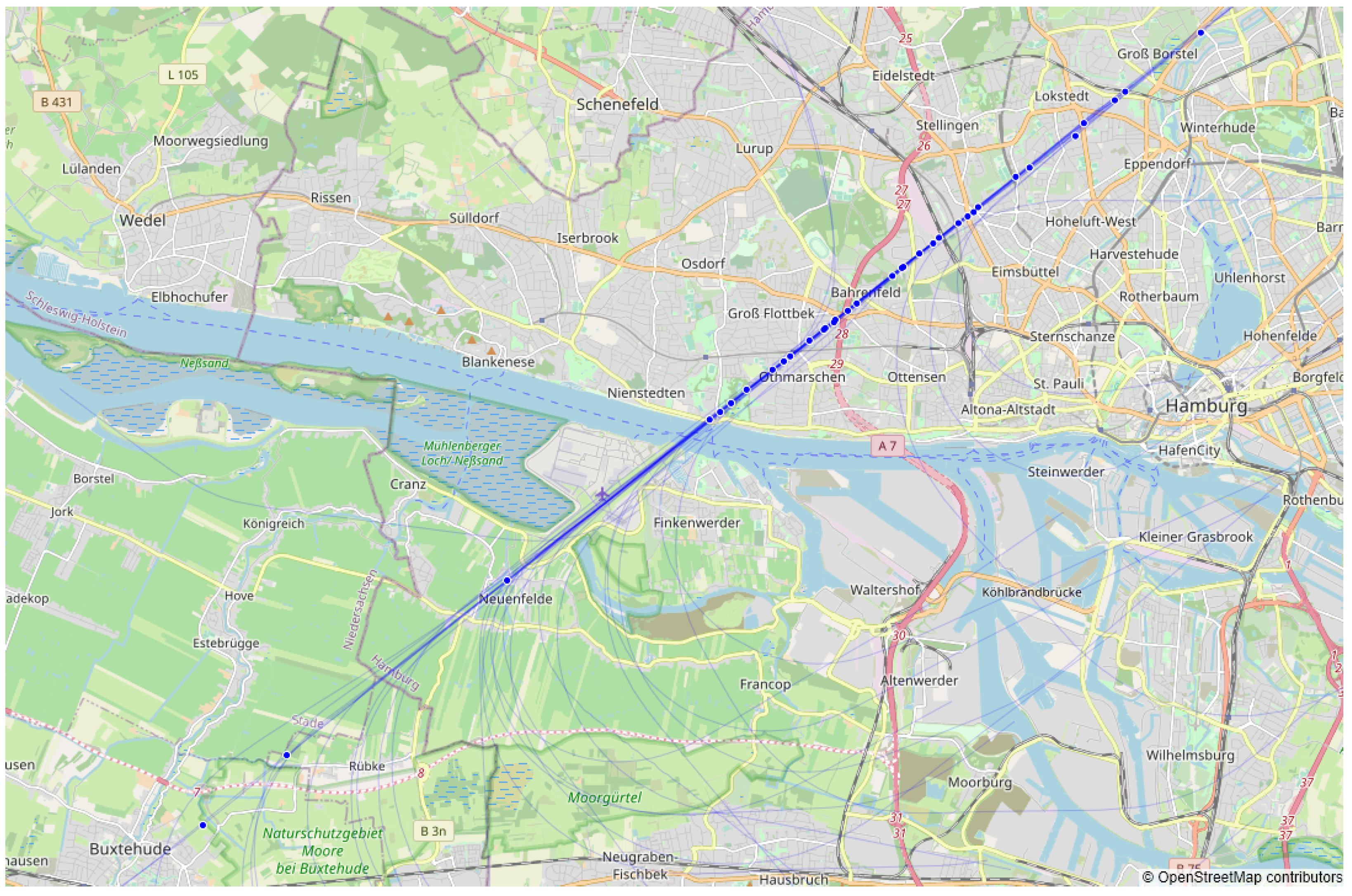
Figure 1. Location of go-around point (blue) for Finkenwerder Airport (runway orientation 05 / 23 and elevation 23 f t above mean sea level) in 2019.
Engproc 28 00005 g001
Figure 2. Distribution of flights over the year 2019, comparison of flights with go-around (total 34) and without (total 988).
Engproc 28 00005 g002
Figure 3. Distribution of largest passing vessel type during North-East approach with (total 27) and without (total 171) go-around.
Engproc 28 00005 g003
Figure 4. Comparison of largest passing vessel dimensions (top), weather conditions (center), and air traffic spacing (bottom) for each flight with (27) and without (172) go-around where vessel traffic was found. Orange line indicates median, green triangle indicates mean.
Engproc 28 00005 g004
Figure 5. Prediction of time to reach runway based on median speed of sample.
Engproc 28 00005 g005
Table 1. Quantity of go-arounds per airline.
AirlineTotal FlightsGo-AroundsGo-Arounds %
Titan Airways (AWC)12675.5%
Volotea (VOE)55991.6%
Germania (GMI)1228342.8%
Airbus Transport International (BGA)44561403.1%
Total63691903.0%
Table 2. Comparison of number of North-East and South-West approaches and vessel traffic for flights in 2019.
Flights with No Go-AroundFlights with at Least 1 Go-Around
Total flights98834
South-West approach2133 *
North-East approach77531 *
North-East approach
with vessel traffic present
17227
* The first approach is considered in flights with multiple go-arounds.
Table 3. Absolute error of best performing speed sample per prediction time.
Prediction Time (min)Median Error (min)Speed Sample Length (min)
5 0.3 10
10 0.8 5
20 2.6 20
30 4.6 10
Publisher’s Note: MDPI stays neutral with regard to jurisdictional claims in published maps and institutional affiliations.