Abstract
A landslide disaster is one of the many natural disasters that often occur in Indonesia. This disaster is one of the difficult to avoid disasters, so it often causes fatalities and large material losses. Currently, mitigation systems for landslide disasters are still less effective in their use. Early warning systems that can give information about the landslide through smartphones could be the best solution for this digital era, because society generally has smartphones and is connected through the internet. The early warning system also demanded the ability to decide the landslide status. Fuzzy logic is one of many types of artificial intelligence used as a decision support system, which is similar to human logic. Therefore, it is necessary to build an early warning system against landslides based on the Internet of Things (IoT) that can determine the status of landslides that occur based on the soil slope using the MPU6050 accelerometer sensor and moisture data using the soil moisture sensor. This system can later monitor the slope and moisture data of the soil and can transmit landslide status on smartphone applications connected to the internet. The result of this research is an IoT-based landslide early warning system that can transmit landslide and soil moisture data and transmit landslide status in the form of push notifications on smartphones using the Blynk application.
1. Introduction
Landslides, often called ground movements, are geological events that occur due to the movement of rocks or soil and are of various types, such as falling rocks or large lumps of soil, and often occur due to high rainfall that causes the soil, especially on the slopes, to become soft and cause landslides [1]. Landslides and erosion are also defined as the process of moving soil or rocks from one higher place to a lower place due to the push of water, wind, or gravitational force [2]. The movement occurs due to the interaction or the influence of several conditions, including geology, morphology, geological structure, hydrogeology, and land.
Landslides are very common disasters in Indonesia that mostly occur due to heavy rainfall. In 2020 according to the BNPB (National Disaster Management Agency of Indonesia), 291 landslides were recorded in Indonesia that caused many casualties and damage to people’s homes and public facilities [3]. The three provinces that most often experience landslides are West Java, Central Java, and Banten.
To be able to prevent landslides, a landslide detection system can be used to monitor landslide-prone points and provide real-time reporting to the public so that predictions of landslides can be made more accurate and precise [4]. This aims to prevent casualties and anticipate the arrival of landslides. Then the early warning system created can utilize Internet of Things (IoT) technology in order to transmit data in real-time. The IoT is able to communicate with devices, both near and far, by using the internet as a communication line.
In the early warning system, it is necessary to make accurate decisions in carrying out its functions. In general a decision-making system can sometimes lead to errors in the system itself [5]. One of the decision-making systems that can be used in a landslide early warning system is the fuzzy logic method [6]. The fuzzy method works like a human mind that can judge decisions not only by truth or falsehood, but sometimes it could be yes, maybe, or no.
Therefore, in this paper, the authors designed an early warning system prototype using two sensors, i.e., the MPU6050 accelerometer sensor, which can support the 9-axis MotionFusion algorithm, and the capacitive soil moisture sensor, which uses the working principle of a capacitor to approximate the moisture content in soil. Both sensors will be controlled by a single microcontroller that has been programmed with an embedded system. Then the microcontroller will receive data from both sensors and then process it using fuzzy logic methods. After processing the data, the microcontroller will send data over the internet to the Blynk application in the form of dashboards and notifications.
2. Related Works
IoT technology enables the seamless integration of heterogeneous sensor networks for landslide monitoring and early warning [7]. By connecting sensors to a centralized platform through wireless communication protocols, IoT-based systems facilitate real-time data collection, transmission, and analysis. These systems offer scalability, flexibility, and remote accessibility, making them well suited for landslide-prone areas with a limited infrastructure [8].
The landslide early warning system requires data from the slope and soil moisture to be able to determine the value of the landslide [9,10]. The MPU6050 sensor can be used as a soil slope detection sensor, and a capacitive soil moisture sensor can be used as a soil moisture detector. Data from the two sensors will be received in the form of raw data that cannot be represented properly. Fuzzy logic can be used as a method for representing, manipulating, and applying heuristic knowledge to control systems [11,12,13].
Fuzzy logic provides a robust framework for modeling the complex and uncertain relationships inherent in landslide prediction. By defining linguistic variables, fuzzy rules, and membership functions, fuzzy logic systems can effectively handle imprecise sensor data and generate timely warnings based on predefined risk thresholds. Fuzzy logic-based approaches enhance the adaptability and responsiveness of landslide early warning systems, thereby improving their reliability in dynamic environments.
Several studies have demonstrated the integration of fuzzy logic methods with multi-sensor networks for landslide early warning purposes [14,15]. By combining data from different types of sensors, such as GPS, rainfall gauges, and soil moisture sensors, these systems can assess landslide risk levels and trigger warnings based on fuzzy inference algorithms. The fusion of multi-sensor data enables comprehensive monitoring of landslide-prone areas and enhances the accuracy of early warning predictions.
The landslide value can be obtained based on data obtained from the two sensors, which are then processed using the fuzzy method and will be forwarded to the Blynk app via the internet [16]. The system used is a system embedded in the Node MCU, which is connected to the two sensors. The integrated system demonstrates effective performance in landslide monitoring and early warnings. Sensor data integration and fuzzy logic processing enable accurate assessment of landslide risk levels. Real-time communication with the Blynk app ensures timely dissemination of warnings to relevant stakeholders, enhancing preparedness and response capabilities [17].
Blynk is a versatile mobile application development platform that enables users to create customized IoT (Internet of Things) applications for controlling and monitoring connected devices remotely [18,19]. It provides a user-friendly interface and a drag-and-drop interface builder and is available for download on major mobile app stores, allowing users to design interactive interfaces without the need for extensive programming knowledge. Blynk offers both a mobile app for end-users and a cloud-based platform for developers to create and manage IoT projects. While the Blynk app was not specifically developed for landslide early warning systems, its customizable interface, cloud connectivity, and support for IoT devices make it well suited for integrating with such systems.
3. System Design
3.1. System Overview
In this research, the system was designed to be able to read the soil slope and moisture using MPU6050 sensors (Invensense Inc., San Jose, CA, USA) and a capacitive soil moisture sensor (DFRobot, Shanghai, China) connected to microcontrollers (Espressif Systems, Shanghai, China). MPU6050 is a sensor module that has two functions in it, namely, an accelerometer with a micro-electromechanical system (MEMS) and a gyroscope with a micro-electromechanical system (MEMS) in a chip. A capacitive soil moisture sensor is a sensor that can detect the intensity of water in the soil (moisture). The output of the system contains data on the soil slope of the X-axis and soil moisture displayed in the Blynk application. Microcontrollers transmit data using WiFi, which is then uploaded to the Blynk Cloud and forwarded to the dashboard contained in the Blynk app (Version 1.2.0). The general overview of this research is shown in Figure 1.
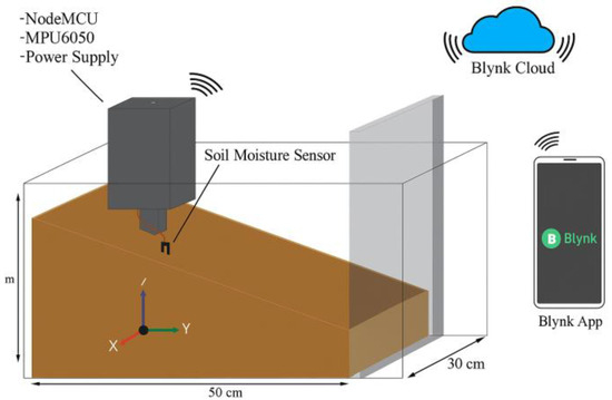
Figure 1.
System overview.
Figure 1 is an overview of the system that will be created in this research. The system is built for research on a prototyping scale. In the main system, there is a Node MCU (Lolin, Shenxhen, China) that is given a power supply from a 9V battery; then there is an MPU6050 sensor that serves as a sensor to read the slope of the ground. Then there is a soil moisture sensor that has been connected to a microcontroller placed at ground level to be able to read the level of soil moisture. And these three systems were integrated and executed within this software. This device will be implanted in the ground with a plastic box to prevent damage to the sensor.
The selection of sensors in a multi-sensor early warning system with a fuzzy logic method based on the Internet of Things (IoT) is crucial and should be justified based on several factors, such as the following:
- Relevance to Landslide Monitoring: The chosen sensors should directly measure parameters relevant to landslide monitoring, such as ground movement, soil moisture content, rainfall, or slope stability. These parameters are often indicative of potential landslide triggers and can help in assessing the risk of slope failure.
- Accuracy and Precision: The sensors should provide accurate and precise measurements to ensure reliable early warning capabilities. High-quality sensors with low error rates and reliable performance under various environmental conditions are preferred to minimize false alarms and improve the system’s effectiveness.
- Compatibility with IoT Infrastructure: The selected sensors should be compatible with the IoT infrastructure, enabling seamless integration into the sensor network and communication with the central data processing and transmission system.
Next, the algorithm used in this device is carried out by an embedded system in a microcontroller that serves to establish a WiFi connection using the WiFi module contained in the Node MCU, perform sensor readings, process sensor data, fuzzify, make decisions, and send data to the Blynk app. The use of the embedded system is also beneficial because it can be used properly for fuzzy logic.
The overall structure of the proposed system is illustrated in Figure 1.
3.2. System Prototype
Figure 2 is a system prototype that will be placed on the surface of the ground that is prone to landslides. The function of this device is to be able to read the slope of the soil using the MPU6050 sensor, and the results of the reading are sent to the microcontroller in the form of a value from the X-axis. In microcontrollers, there are algorithms for data processing and decision-making on whether landslides occur or not. After the microcontroller obtains the results of the next decision, it will send a message to the user’s phone using the Blynk application in the form of status notifications from landslides with WiFi modules contained in the NodeMCU ESP8266.
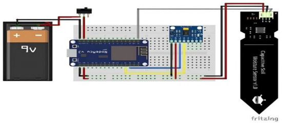
Figure 2.
System prototype.
The prototype developed for landslide monitoring is shown in Figure 2.
3.3. Fuzzy System
Fuzzification is the process of converting assertive value inputs into linguistic variables using the membership function of membership functions stored in a fuzzy knowledge base. In this research, variables were made into 2 sets that have linguistic values. The sets are created with variables that have the following linguistic values:
- Ground slope = {flat, slope, steep} = {D, Ld, T};
- Soil moisture = {dry, moist, wet} = {K, Lb, B}.
Here are the membership functions of each input variable:
Ground Slope Membership Function. The classification of ground slopes based on the applied algorithm is made with a range of values, as shown in Table 1 below.

Table 1.
Ground slope value range.
The fuzzy system applied in this research is presented in Figure 3.
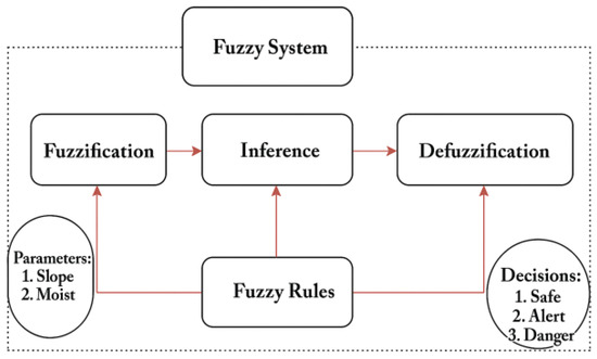
Figure 3.
Fuzzy system.
The slope value of the ground is determined based on the slope value on the sensor, which is converted into the following degrees. The detailed specifications of the MPU6050 and the capacitive soil moisture sensor used in this study are summarized in Table 2.
Table 2.
Conversion value.
The ground slope sensor has flat, slope, and steep linguistic values. The membership graph for the slope of the land is depicted in Figure 4 below.
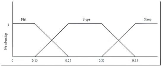
Figure 4.
Ground slope membership graph.
The membership functions of the soil slope variable based on the graph above are as follows:
Soil Moisture Membership Function. The applied soil moisture classification of sensors and algorithms is made with a range of values, such as those in Table 3.
Table 3.
Soil moisture value range.
Soil moisture sensors have dry, moist, and wet linguistic values. The membership chart for soil moisture is depicted in Figure 5 below.
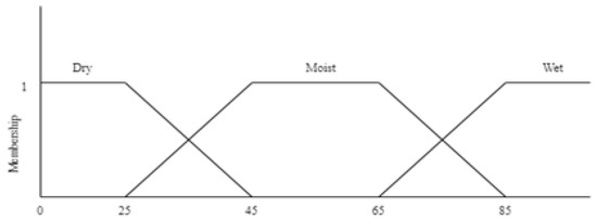
Figure 5.
Soil moisture membership graph.
The membership functions of the soil moisture variable based on the graph above are as follows:
3.3.1. Inference
Inference is the most important part of fuzzy logic, because inference contains rules that will produce outputs in the form of decisions in this research. The inference built produces an output in the form of a safe status indicator, alert, and danger, where the output is obtained from the value of the soil slope and soil moisture. There are 9 fuzzy rules used based on variables and linguistics, as follows:
- IF flat slope AND dry moisture THEN safe;
- IF flat slope AND moist moisture THEN safe;
- IF slope slope AND dry moisture THEN safe;
- IF flat slope AND wet moisture THEN alert;
- IF slope slope AND moist moisture THEN alert;
- IF steep slope AND dry moisture THEN alert;
- IF slope slope AND wet moisture THEN danger;
- IF steep slope AND moist moisture THEN danger;
- IF steep slope AND wet moisture THEN danger.
3.3.2. Fuzzy Rules
The fuzzy logic knowledge base is a collection of fuzzy rules in the form of IF-THEN statements related to inference. The rules result from three variables with the linguistics of each membership. Then the linguistics are made into rules, as shown in Table 4.
Table 4.
Fuzzy rules.
3.3.3. Defuzzification
Defuzzification is the last stage in the fuzzy logic stage to obtain the output from the inference stage as a crisp value using the membership function that has been created at the fuzzification stage. In Figure 6 we determined the output result of the defuzzification stage in the form of a percentage of landslide values of 1–100, where a value below 10 is the safe landslide status, between 10 and 70 is alert, and above 70 is hazards. In determining the landslide value, the Sugeno method and defuzzification formula are used by taking the α-predicate value at the inference stage, used to expressly calculate the output of the inference results (crisp) of each rule ).
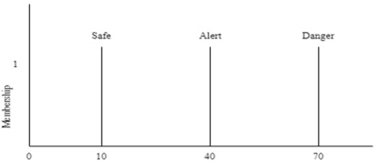
Figure 6.
Landslide value membership function.
The output membership function for landslide values obtained through defuzzication is depicted in Figure 6.
The defuzzification stage of the Sugeno method uses the average as follows:
4. Simulation Results
The test was carried out by conducting simulations in a 60 cm long box, 25 cm wide, and 40 cm high. The landslide detection device was implanted 10 cm deep in the ground, then observed during the movement of the ground, and samples were taken as many as 20 times. Landslide simulation is performed by raising the level of soil moisture by watering the soil. According to research conducted, there is an influence of the soil slope on soil moisture that can affect the state of landslides. The effect of the soil slope on soil moisture can be seen in Table 5.
Table 5.
Soil slope influence on soil moisture.
In Table 5 it can be seen that the slope of the soil and the level of soil moisture are inversely proportional, where the greater the condition of the slope of the soil, the lower the level of soil moisture needed, and vice versa. Based on the data above, the simulation determined that the slope of the ground on the box is approximately 30 degrees.
Simulations of the test scenarios in this research can be seen in Figure 7.
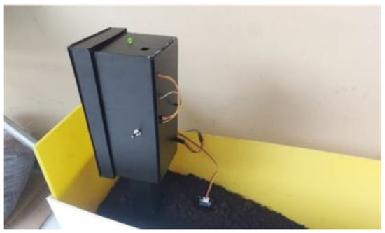
Figure 7.
Device planted in simulation box.
Tests that were performed obtained results from devices that were designed, and data transmitted by microcontrollers was received in the Blynk app. The data displayed on the Blynk App was recorded every 15 s, 20 times, during ground movement. Data was recorded manually based on the data displayed on the Blynk app, as shown in Figure 8.
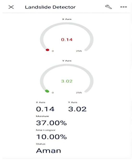
Figure 8.
Data displayed in Blynk app.
From Table 5 it can be concluded that the accuracy value for the sample of tested data is 90%.
For fuzzy calculations of each sample taken, with one per sample status as a reference, the calculation of the safe status in Test 6 is as follows:
- Fuzzification
- Soil slope = 0.03.
In Table 6 the slope of the soil 0.03 is included in the membership function of the Equation (1), namely
Table 6.
Data testing table.
- Soil moisture = 43.
And equation , which is
- 2.
- Inference
At the inference stage, a search is performed on the Min/Max value. The Min function is an application of the knowledge base contained in Table 4 and the Max function of each rule to produce the final fuzzy value.
- IF flat slope 1 AND dry moisture 0.1 THEN safe 0.1;
- IF flat slope 1 AND moist moisture 0.9 THEN safe 0.9;
- The final fuzzy value is safe 0.1 OR 0.9, which is 0.9.
- 3.
- Defuzzification
The process of defuzzification of the Sugeno method uses the average method as in Equation (7), namely
From the results of defuzzification obtained, if the slope is 0.03 and the moisture is 43, a safe status will be obtained with a landslide value of 10.
In this test, the alert and danger status were successfully sent in the form of a push notification to the Blynk app, as seen in Figure 9.
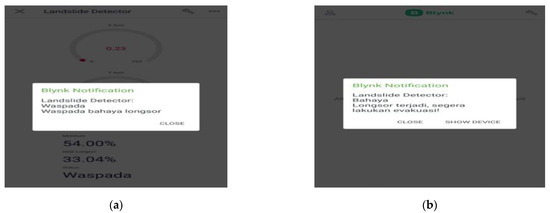
Figure 9.
Blynk notification (a) and Blynk notification (b).
5. Conclusions
The results of our study highlight the effectiveness of the proposed multi-sensor early warning system with a fuzzy logic method based on IoT technology. By leveraging a combination of sensor data fusion, fuzzy logic reasoning, and internet connectivity, the system offers a comprehensive solution for landslide monitoring and risk assessment. The integration with the Blynk application enhances the system’s accessibility and usability, enabling users to receive actionable information and respond promptly to potential landslide threats. Even though the device can detect landslide movement based on soil moisture, it has not been optimal in detecting soil movement. Meanwhile, the warning system in this research can also send data well to Android by using the Blynk app, which can display the state of the ground data.
Despite the advancements in IoT and fuzzy logic technologies, several challenges remain in the development and deployment of multi-sensor early warning systems. These challenges include data fusion from heterogeneous sensor sources, optimization of fuzzy logic parameters, and validation of system performance under diverse environmental conditions. Future research directions may focus on the integration of machine learning techniques, such as neural networks and evolutionary algorithms, to further enhance the capabilities of IoT-based early warning systems.
Author Contributions
Conceptualization, F.A. and D.W.; methodology, F.A. and D.S.; software, H.F.; validation, D.W. and D.S.; formal analysis, F.A.; investigation, F.A.; resources, D.W.; data curation, H.F.; writing—original draft preparation, F.A.; writing—review and editing, D.W. and D.S.; visualization, H.F.; supervision, D.W.; project administration, D.W. All authors have read and agreed to the published version of the manuscript.
Funding
This research received no external funding.
Institutional Review Board Statement
Not applicable.
Informed Consent Statement
Not applicable.
Data Availability Statement
The data supporting the findings of this study are available from the corresponding author upon reasonable request.
Conflicts of Interest
The authors declare no conflict of interest.
References
- Canli, E.; Loigge, B.; Glade, T. Spatially Distributed Rainfall Information and Its Potential for Regional Landslide Early Warning Systems. Nat. Hazards 2018, 91, 103–127. [Google Scholar] [CrossRef]
- Yang, Z.; Qiao, J.; Zhang, X. Regional Landslide Zonation Based on Entropy Method in Three Gorges Area, China. In Proceedings of the Seventh International Conference on Fuzzy Systems and Knowledge Discovery (FSKD 2010), Yantai, China, 10–12 August 2010; pp. 1336–1339. [Google Scholar]
- Gunawan, G.; Rahman, A.; Seputro, B.P.; Elsera, M. Design of Early Warning System Flood and Landslide Mitigation Sensor Based on Internet of Thing. J. Phys. Conf. Ser. 2019, 1361, 012062. [Google Scholar] [CrossRef]
- Oguz, E.A.; Robinson, K.; Depina, I.; Thakur, V. IoT-Based Strategies for Risk Management of Rainfall-Induced Landslides: A Review. In Proceedings of the 7th International Symposium on Geotechnical Safety and Risk (ISGSR 2019), Taipei, Taiwan, 11–13 December 2019; pp. 733–738. [Google Scholar]
- Gamperl, M.; Singer, J.; Thuro, K. Internet of Things Geosensor Network for Cost-Effective Landslide Early Warning Systems. Sensors 2021, 21, 2609. [Google Scholar] [CrossRef] [PubMed]
- Othman, S.M.; Abdulrazzaq, M.B. Fuzzy Logic System for Drug Storage Based on the Internet of Things: A Survey. Indones. J. Electr. Eng. Comput. Sci. 2023, 29, 1382–1392. [Google Scholar] [CrossRef]
- Prasetyo, A.; Yusuf, A.R.; Litanianda, Y.; Sugianti, S.; Masykur, F. Implementation of Fuzzy Logic for Chili Irrigation Integrated with Internet of Things. J. Comput. Netw. Archit. High Perform. Comput. 2023, 5, 494–502. [Google Scholar] [CrossRef]
- Henao-Céspedes, V.; Garcés-Gómez, Y.A.; Marín Olaya, M.N. Landslide Early Warning Systems: A Perspective from the Internet of Things. Int. J. Electr. Comput. Eng. 2023, 13, 2214–2222. [Google Scholar] [CrossRef]
- Dhanagopal, R.; Muthukumar, B. A Model for Low Power, High Speed and Energy Efficient Early Landslide Detection System Using IoT. Wirel. Pers. Commun. 2021, 117, 2713–2728. [Google Scholar] [CrossRef]
- Sofwan, A.; Sumardi; Ridho, M.; Goni, A.; Najib. Wireless Sensor Network Design for Landslide Warning System in IoT Architecture. In Proceedings of the 4th International Conference on Information Technology, Computer and Electrical Engineering (ICITACEE 2017), Semarang, Indonesia, 18–19 October 2017; pp. 280–283. [Google Scholar]
- Chaturvedi, P.; Thakur, K.K.; Mali, N.; Kala, V.U.; Kumar, S.; Yadav, S.; Dutt, V. A Low-Cost IoT Framework for Landslide Prediction and Risk Communication. In Internet of Things A to Z: Technologies and Applications; Hassan, Q., Ed.; John Wiley & Sons, Inc.: Hoboken, NJ, USA, 2018; pp. 593–610. [Google Scholar]
- Elavarasi, K.; Nandhini, S. Landslide Monitoring and Tracking Using Iot Sensors. J. Phys. Conf. Ser. 2021, 1717, 012060. [Google Scholar] [CrossRef]
- Fakhrurroja, H.; Triono, E.; Munandar, A. Water Quality Assessment Monitoring System Using Fuzzy Logic and the Internet of Things. J. Mechatron. Electr. Power Veh. Technol. 2023, 14, 198–207. [Google Scholar] [CrossRef]
- Castañeda, J.H.; Perez, P.C.T.; Paiva-Peredo, E.; Zarate-Segura, G. Design of a Prototype for Sending Fire Notifications in Homes Using Fuzzy Logic and Internet of Things. Int. J. Electr. Comput. Eng. 2024, 14, 248–257. [Google Scholar] [CrossRef]
- Morello, R.; De Capua, C.; Lugarà, M. The Design of a Sensor Network Based on Iot Technology for Landslide Hazard Assessment. In Proceedings of the 4th Imeko TC19 Symposium on Environmental Instrumentation and Measurements Protecting Environment, Climate Changes and Pollution Control, Lecce, Italy, 3–4 June 2024; pp. 99–103. [Google Scholar]
- Idris, A.; Hafez, M.A.; Sidek, N.; Zailani, W.W.A.; Baharuddin, N.A.Z.M. Smart Monitoring and Warning Landslide System using Internet of Things. Math. Stat. Eng. Appl. 2022, 71, 7226–7238. [Google Scholar]
- Thirugnanam, H.; Uhlemann, S.; Reghunadh, R.; Ramesh, M.V.; Rangan, V.P. Review of Landslide Monitoring Techniques With IoT Integration Opportunities. IEEE J. Sel. Top. Appl. Earth Obs. Remote Sens. 2022, 15, 5317–5338. [Google Scholar] [CrossRef]
- Sharma, P.; Kantha, P. “Blynk” Cloud Server based Monitoring and Control using “NodeMCU”. Int. Res. J. Eng. Technol. 2020, 7, 1362–1366. [Google Scholar]
- Helmy, S.M.A.; Amar, a.m.; El-Horabty, E.-S.M. Internet of Things (IoT) based smart device for cardiac patients monitoring using Blynk App. Int. J. Intell. Comput. Inf. Sci. 2022, 22, 86–99. [Google Scholar]


Disclaimer/Publisher’s Note: The statements, opinions and data contained in all publications are solely those of the individual author(s) and contributor(s) and not of MDPI and/or the editor(s). MDPI and/or the editor(s) disclaim responsibility for any injury to people or property resulting from any ideas, methods, instructions or products referred to in the content. |
© 2025 by the authors. Licensee MDPI, Basel, Switzerland. This article is an open access article distributed under the terms and conditions of the Creative Commons Attribution (CC BY) license (https://creativecommons.org/licenses/by/4.0/).