Abstract
Earthen flood protection structures are planned and constructed with an expected service life of several decades while being exposed to environmental impacts that may lead to structural or hydraulic failure. Current maintenance procedures involve only repairing external damage, leaving internal processes contributing to structural damage often undetected. Through structural health monitoring (SHM), structural deficits can be detected before visible damage occurs. To improve maintenance workflows and support predictive maintenance of dikes, this paper reports on the integration of digital twin concepts with SHM strategies, referred to as “digital-twin-based SHM”. A digital twin concept, including a standard-compliant building information model, is proposed and implemented in terms of a digital twin environment. For integrating monitoring and sensor data into the digital twin environment, a customized webform is designed. A communication protocol links preprocessed sensor data stored on a server with the digital twin environment, enabling model-based visualization and contextualization of the sensor data. As will be shown in this paper, a digital twin environment is set up and managed in the context of SHM in compliance with technical standards and using well-established software tools. In conclusion, digital-twin-based SHM, as proposed in this paper, has proven to advance predictive maintenance of dikes, contributing to the resilience of critical infrastructure against environmental impacts.
1. Introduction
Civil infrastructure is designed and built with an expected service life spanning several decades, while being exposed to environmental and other external impacts. As infrastructure ages, it deteriorates, increasing the risk of damage that may cause structural failure [1,2]. Currently, corrective maintenance is the predominant approach usually employed for civil infrastructure, aiming to detect visible damage through periodic manual inspections [3]. However, corrective maintenance may lead to unplanned availability restrictions due to short-term maintenance interventions or, in the worst case, unforeseen structural failure caused by ongoing internal, thus invisible, damage.
To reduce the risk of damage, periodic manual inspections, as part of corrective maintenance strategies, may be enhanced with sensor-based data on the internal condition of structures [4]. Continuous access to condition data forms the foundation for structural health monitoring (SHM) and early-warning systems, aiming to prevent severe damage [5]. The condition data, as well as the corresponding continuous condition assessment, enables engineers and authorities to execute predictive maintenance by identifying anomalies, indicative of structural deficits, before visible damage occurs [6]. To monitor parameters relevant to the structural health, sensor networks are deployed to civil infrastructure [7,8]. These sensor networks can also be set up as wireless smart sensor networks [9,10]. The data recorded by the sensor networks is transferred to software environments, where the infrastructure condition is analyzed in depth [11].
The maintenance phase of civil infrastructure leverages digital twins that are continuously updated with sensor data. A digital twin is a digital, dynamic representation of a real-world entity that mirrors and synchronizes bidirectionally with its real-world counterpart throughout its life cycle [12,13,14,15]. As stated by the National Academy of Science and Engineering, Germany, a digital twin includes data from its real twin, such as geometry, kinetics, and logic. Simulations of processes connected to a physical twin support control and optimization of the physical structure [16].
Recent studies have shown the advantages of combining digital twins and SHM in Civil Engineering [15] and for Disaster Risk Management in particular [17,18]. Integrating digital twins and SHM is being introduced and tested within pilot projects for civil infrastructure [19]. Furthermore, concepts and frameworks for developing digital twins in the construction industry that support generating forecasts and decision-making for maintenance procedures are proposed [20,21,22]. Key priorities include developing standards and workflows across diverse project and structure types, while focusing on the overall goal to increase the resilience of (critical) infrastructure.
The resilience of critical Infrastructure is increasingly threatened by recurring and intensifying environmental influences, such as extreme flood events. An important area of research has therefore been the application of digital twins for emergency and disaster management as well as early-warning systems [23,24,25,26,27]. Flood events in Germany with severe consequences, such as the flooding of the Steinbachtalsperre in North Rhine-Westphalia in 2021 [28] or high water levels as in winter 2023, which have been extreme in both height as well as duration, have revealed deficits in current solutions for flood protection and emphasize the urgent need to understand the condition of flood protection structures [29]. To deepen the understanding of geotechnical failure mechanisms in dikes, the Dutch research program IjkDijk, launched in 2005, has been aiming to test advanced SHM techniques under field conditions. To investigate the predictive capabilities of SHM systems across various dike failure mechanisms, three large-scale tests have been carried out [30]. The SHM system has included remote sensing technologies as well as surface geophysical methods and fiber-optic sensors, with the data processed to trigger warnings in case of imminent failure. By integrating visual inspections with pore water pressure monitoring results, the program successfully reconstructed piping mechanisms that had developed within the dike over time [31].
The research project EarlyDike aims to develop a reliable sensor-based early-warning system for detecting failure mechanisms in dikes [32]. A sensor-based real-time monitoring system, integrating smart geotextiles and conventional sensors within a dike, has been established to provide condition-based early warnings. The sensor data has been analyzed and uploaded to an online monitoring interface, also used for predictions of storm surge water levels and wave impact simulations. Furthermore, a sensor and geodata infrastructure has been developed, integrating results from different sensors and simulations, implemented to generate and assess condition indicators to facilitate local risk assessment. The data and information structure adheres to national (MDI-DE [33] and GDI-DE [34]) and international (INSPIRE [35]) standards, ensuring interoperability with existing early-warning systems and forecasting tools. However, specific digital twin applications for earthen flood protection structures currently remain within laboratory environments and have barely reached practical application.
This paper aims to enhance the maintenance of earthen flood protection structures through the implementation of digital-twin-based SHM. A data workflow is presented, which enables the use of commercially available and reliable building information modeling (BIM) software products for digital twin management. Along with adherence to current Internet of Things (IoT) standards, the approach proposed in this paper enables model-based visualizations and analyses of sensor data based on widely available BIM software products. A digital twin of a dike has been developed to set up a digital-twin-based SHM environment. The SHM concept includes a sensor network consisting of individual pressure sensors, devised to measure the water pressure in the dike and to derive internal water levels. The software environment hosting the digital twin, hereinafter referred to as “digital twin environment”, is linked to a server hosting the sensor data. The implementation results demonstrate that sensor data integration is feasible using established technical standards. Hereby, the possibilities for maintenance are extended regarding predictive maintenance, which potentially increases the resilience of dikes. The implementation also creates a precondition to set up a bidirectional link that enables sensor network modifications, such as adapting the measuring frequency. The approach described in this paper can be transferred to different structures, sensor types, and SHM configurations.
The remainder of this paper is structured as follows. First, the requirements for geometric, parametric, and technical aspects essential for designing digital twins for dike monitoring are discussed. Next, the sectional dike constructed under laboratory conditions used as a demonstrator in this research, along with the implementation of a digital-twin-based SHM system, is presented. The setup of the digital twin environment, including a tailor-made webform for SHM applications, incorporating the requirements identified beforehand, serves to validate the process of establishing a digital-twin-based SHM system. Finally, the paper concludes with a summary of the results and suggests potential directions for future research.
2. Designing a Digital Twin for Monitoring Dikes
The following paragraphs discuss general requirements for incorporating both as-built and as-is data into digital twins to facilitate model-based, predictive maintenance. In addition, technical approaches for fulfilling each requirement are proposed, providing a foundation for implementing digital-twin-based SHM, as detailed in Section 3. The requirements address current issues observed in periodic inspections, where non-digitalized methods often lead to inaccurate and unstructured data management [36].
By combining site measurements with satellite data and geo-survey methods, dikes can be digitalized and georeferenced for integration into digital twin environments [37]. Constructions, such as culverts, bridge abutments, or intake structures located within dikes, must also be represented within a digital twin. For improved orientation, dike sections as specified in [8] should be represented in the digital twin as well. Modeling technical equipment, e.g., sensors, pipes, and signage, adds value to a digital twin because additional object information can be linked accordingly. Also, designated areas, such as grazing areas or natural reserves, can be represented to improve traceability of anomalies and to classify unauthorized usage. Conventional data that exists in the form of documents or pictures is to be manually integrated into digital twins, following the approach of a single source of truth, which allows linking data from various sources via weblinks, but constrains the multiple storage of data in different locations [36]. For mapping information about the construction to a digital twin, dike geometry and construction materials, including as-built physical and geotechnical parameters, must be integrated [38].
To qualify as a digital twin, time-related information, which is essential for tracking changes over time, must be incorporated, assessing damage progression, and understanding current usage specifications [39]. Regarding the complexity of civil engineering projects and the continuous influx of sensor data, the data input should follow a “right-time” twinning rather than a “real-time” twinning concept, thereby avoiding performance degradation from sensor data overload [20]. In SHM, time-related information relevant to digital twins includes any data that reflects the current condition of a dike (as-is data) [24]. As-is data may be obtained by sensors that monitor structural parameters, indicating structural changes over time [40]. Within digital twin environments, as-is data must be linked to the corresponding sensors. Beyond sensor data, information on environmental conditions is also crucial, as it informs about potentially increasing loads from natural impacts like wind, waves, and tides [41]. By contextualizing dike parameters with environmental conditions, dependencies between load variations and structural responses must be identified [39]. The type and frequency of data input may differ for each digital twin, depending on the overall use case and availability. It is to be noted that the input of raw, quickly changing data may decrease the performance of the digital twin and must therefore be avoided [41]. Instead, sensor data must be aggregated and filtered to display significant developments, such as customized condition indicators, over time. To integrate heterogeneous data emerging from the different sources described above, a flexibility regarding data processing is essential [36]. To enable automated condition assessment within a digital twin environment—thereby reducing manual inspection effort and simplifying decision-making—the integration of as-is data recorded by sensor networks is essential. Additionally, visible damage must be represented within the digital twin as an object associated with a specific section or material. Each damage object is to be parameterized, specifying its type and severity. By linking damage objects to a corresponding dike element, contextualization and assessment of potential damage consequences become possible. Recording and managing sensor data must be automated through smart sensor systems, with each sensor node filtering and preprocessing raw data on board [42]. Data processing must adhere to boundary conditions tailored to stakeholder interests and the specific needs of the structure. To ensure clear data visualization, customization of the user interfaces within a digital twin environment is required.
Last, but not least, in addition to processing real-time data, time-variant changes in structural condition must be analyzed and visualized to monitor the structural lifecycle. When internal or external structural damage is detected, the affected area must be represented in the digital twin environment as an object-oriented reference. The digital twin environment is then expected to maintain high usability, with significantly reduced manual documentation effort compared to current inspection workflows. The requirements described in the previous paragraphs and the implementations in the research underlying this paper are summarized in Table 1, providing a step-by-step process for building a digital twin.

Table 1.
Recommendations for implementing digital twins guided by requirements for model-based, predictive maintenance.
3. Implementation of the Digital Twin Environment
Drawing from the requirements above, a digital-twin-based SHM concept is implemented on a laboratory-made dike as described in the following section. First, the dike, including the corresponding BIM model, is presented, followed by the implementation of the digital twin environment.
3.1. Dike and BIM Model
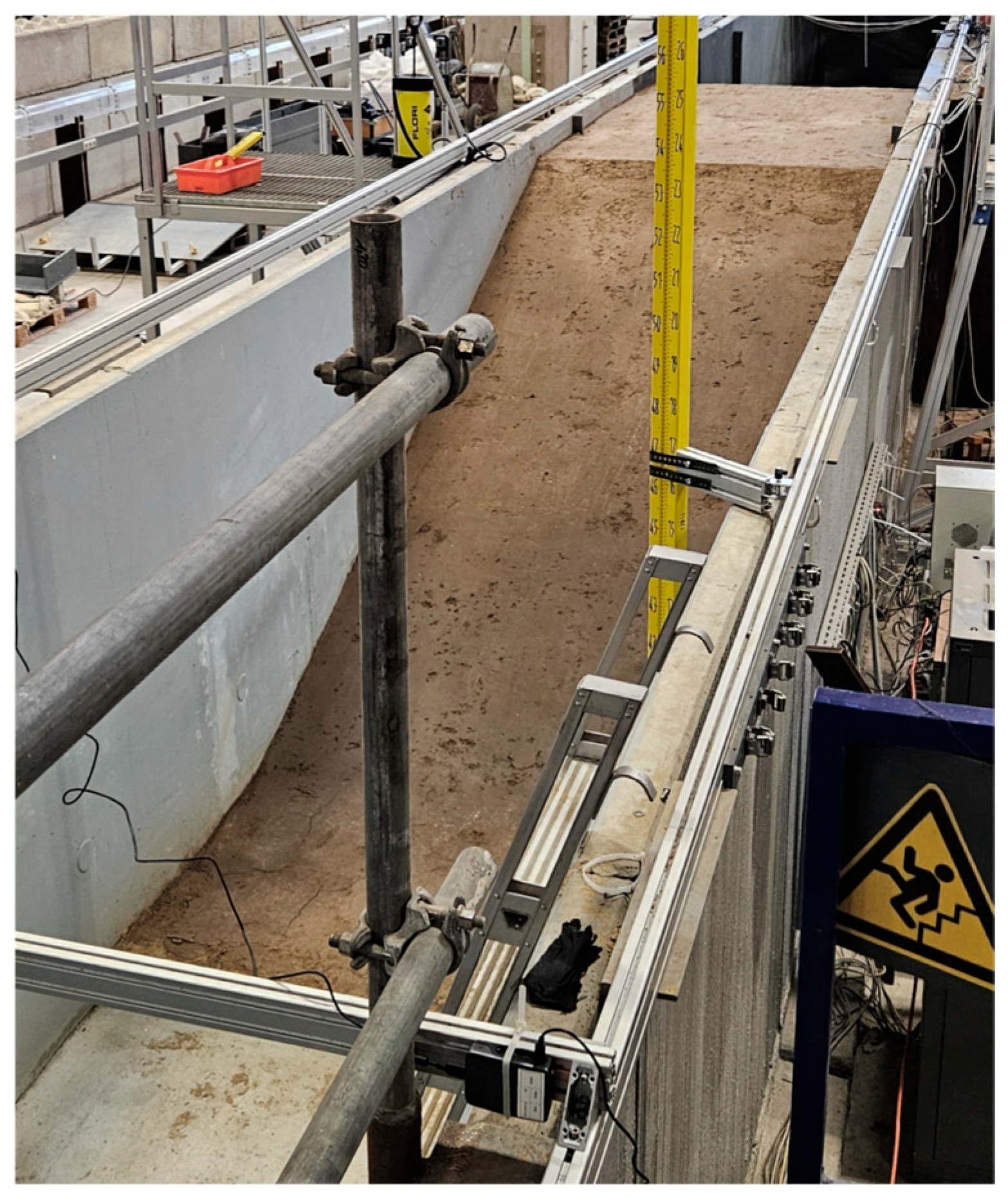
The dike, incorporating a sensor network of nine pressure sensors, is constructed within a concrete channel at the Institute of Hydraulic Engineering and Water Resources Management at RWTH Aachen University in Germany (Figure 1).

Figure 1.
Dike construction within the experimental concrete channel at RWTH Aachen.
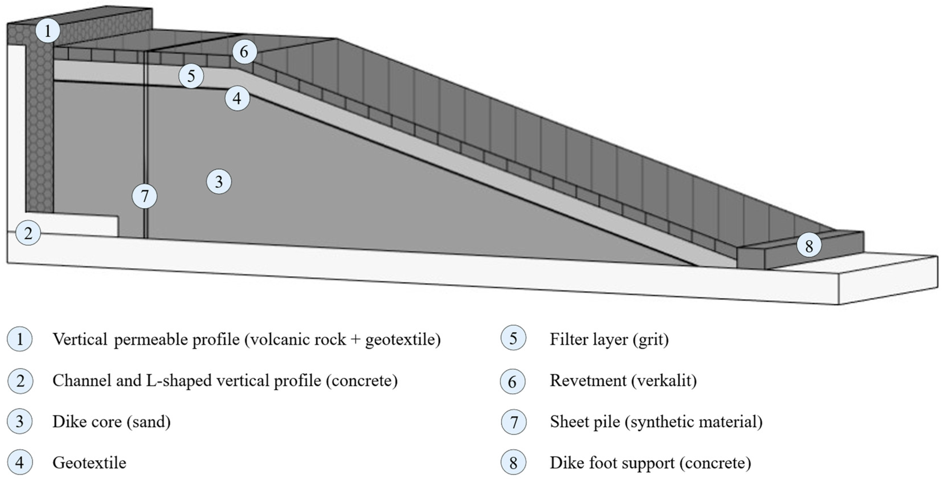
A corresponding BIM model is created, considering the geometry and material specifications of the dike. The dike consists of a land-facing half, with a vertical wall in place of a slope on the water-facing side (Figure 2). To simulate the water-facing side and enable a uniform flow for seepage testing, an L-shaped, partially open concrete profile with an attached vertical profile of volcanic rock and permeable geotextile is constructed. The core of the dike consists of a washed medium sand (0/2 mm) with 0.8% silt. The core is covered with a geotextile and a filter layer (grit), forming a revetment system with an interlocked Verkalit pavement layer across the dike slope and crown. An internal, vertical, non-permeable plastic sheet pile serves as a seal, with permeability provided only through the partially unsealed sheet pile locking system. The dike foot is reinforced by a concrete support.
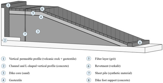
Figure 2.
BIM model of the dike.
For integration into the digital twin environment, the dike is modeled as a 3D representation. Each dike element is modeled as an individual structural proxy element and is parameterized according to its material and object classification. In addition, cube-shaped proxy elements with an outer dimension of 0.1 m, representing the pressure sensors (U1-U9) within the dike, are modeled at their specific location at the base of the dike core (Figure 3).
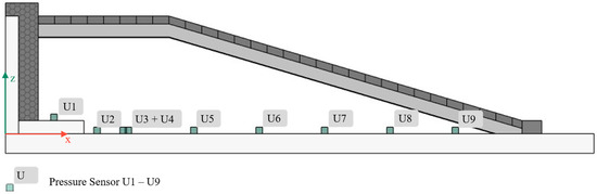
Figure 3.
Cross-section of the dike with pressure sensors.
The functionality of the pressure sensors along the dike is based on the principle of communicating pipes. At each sensor location, one end of a water-filled polyamide tube with a 6 mm diameter is fixed in a vertical position. A pneumatic muffler, made of stainless-steel wire mesh, seals the tube, preventing sediment infiltration. Each tube runs along a small channel at the bottom level of the dike and is connected to a pressure calibrator outside the dike. Each sensor generates one data point every two minutes, with each data point being the calculated average of ten individual measurements recorded at 3.33 Hz. Upon modeling the geometries and semantics described above, and after assigning the sensor data, the BIM model is exported to the IFC 4.1 format [43] to make it available for further processing in the digital twin environment.
3.2. Digital Twin Environment
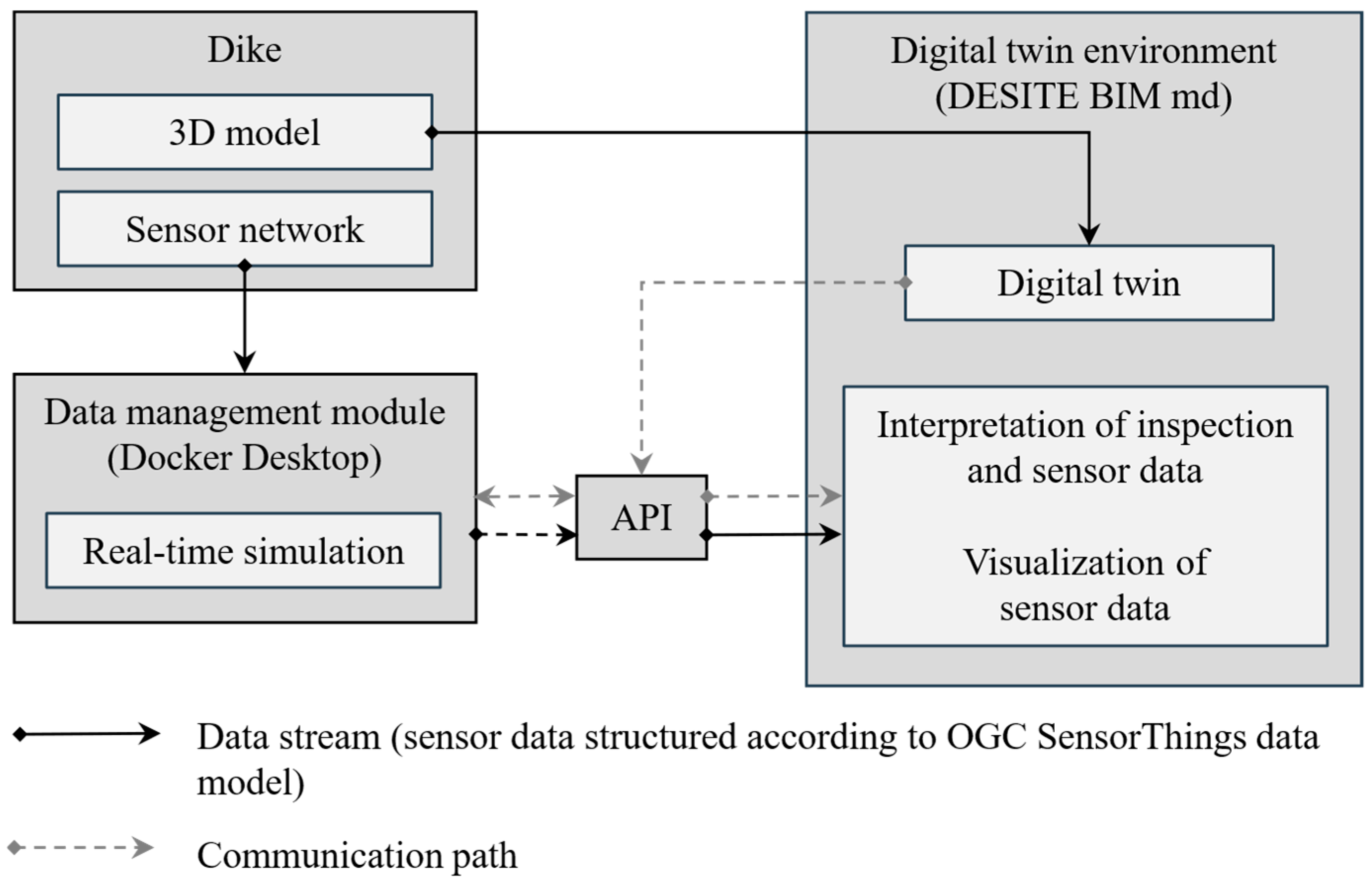
The digital twin environment is connected to the dike, as shown in Figure 4. The sensor data generated by the sensor network (pressure sensors U1-U9) is provided via a data management module implemented in the software Docker Desktop version 4.18.0 [44]. The data management module has been developed by the Chair of Building Informatics and Geoinformation Systems and the Geodetic Institute at RWTH Aachen University. Within the data management module, a real-time simulation runs, repeating and randomizing past data streams, enabling the availability of new data points at a specified frequency. This technical solution is chosen to decouple any processes from time-consuming dike construction and risks arising from the uncertain reliability of an untested sensor network. When activating the real-time simulation, data streams are generated and are accessible from within the digital twin environment via an HTTP request or an MQTT subscription [45].
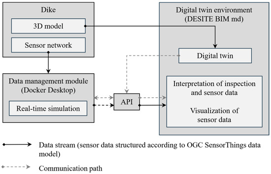
Figure 4.
Architecture of the digital twin environment.
The digital twin environment used in the context of this paper is set up in the thinkproject software DESITE md 3.2 [46]. The proprietary DESITE md application programming interface (API) used for communicating with the data management module enables the implementation of HTTP or MQTT communication through webforms that consist of JavaScript code embedded within an HTML interface. Executing either communication protocol retrieves the requested sensor data from the data management module. Typically, repetitive HTTP requests with specific filters applied to the sensor data are executed, returning the requested data in JSON format, enabling real-time communication between the sensor network and the digital twin environment while also providing access to historical measurements to support the assessment of condition progression.
To store sensor data, an open-source server developed by the Fraunhofer Institute of Optronics, System Technologies, and Image Exploitation is utilized. This server, known as the Fraunhofer Open-Source SensorThings API (FROST) Server, provides access to the OGC SensorThings API [47,48]. To transmit sensor data via the API, data streams must be structured according to the OGC SensorThings data model (Figure 5). Each individual sensor is defined as an entity called a Thing, incorporating a list of predefined properties. In addition, each Thing is related to further entities describing various properties connected to a Sensor. The entity named Sensor contains general information about the sensor type of the individual Thing. The measurements are stored inside the entity Observation in the property result. For each result value, the resultTime property holds information about the timestamp when the result was recorded [48]. The sensor data within the data management module used in the context of this paper is structured according to the OGC SensorThings data model and is accessible via the OGC SensorThings API.
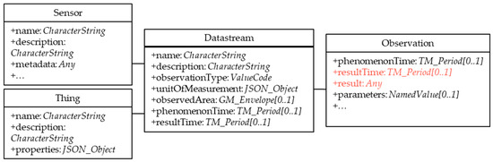
Figure 5.
Extract of the structure of the OGC SensorThings API with predefined entities and properties [48].
4. Validation of the Digital-Twin-Based SHM Approach
This section describes the validation of the digital-twin-based SHM approach, first illustrating the validation method and procedure, followed by presentation of the results and a discussion. Specific focus is emphasized on the data returned by the function managing communication between the digital twin environment and the server hosting the sensor data. This validation process verifies both the data structure and accuracy, ensuring compliance with the OGC SensorThings data model and the proper functionality of the communication pathways.
4.1. Validation Method and Procedure
The sensor data is accessible via a localhost address that can be requested via the DESITE md API. The DESITE md API allows the implementation of communication protocols such as HTTP or MQTT via individual webforms that are integrated into the digital twin environment. The execution of either communication protocol results in the provision of the sensor data as a JSON object. An HTTP request, containing filters that apply to the OGC SensorThings data model, is executed once and provides the requested data (Listing 1). By calling the asynchronous function getLatestData with corresponding values for the parameters Datastream and numDataPoints, an HTTP request is initiated. Identifying the requested Datastream entity within the OGC SensorThings data model, the property values resultTime and result belonging to the entity Observation are returned. The Observations to be fetched are defined via the parameter numDataPoints. The obtained data stream is provided as a JSON object for further processing.
| Listing 1. Asynchronous function within the DESITE md webform that requests the property values belonging to the resultTime and result properties from Observations of a defined Datastream within the OGC SensorThings data model. |
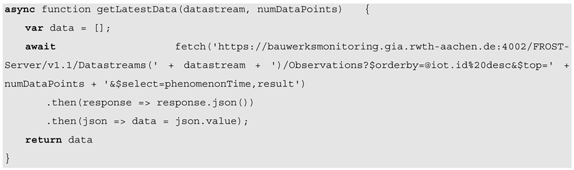 |
The function shown in Listing 1 provides the property values for the requested properties, resultTime and result, from the latest available data. The accuracy of the returned data is validated by comparing the returned data with the live data stream on the server. The structure of the sensor data is validated by verifying that each Observation is assigned to one distinct Datastream and Thing and therefore meets the requirements of the OGC SensorThings data model.
4.2. Results of the Validation
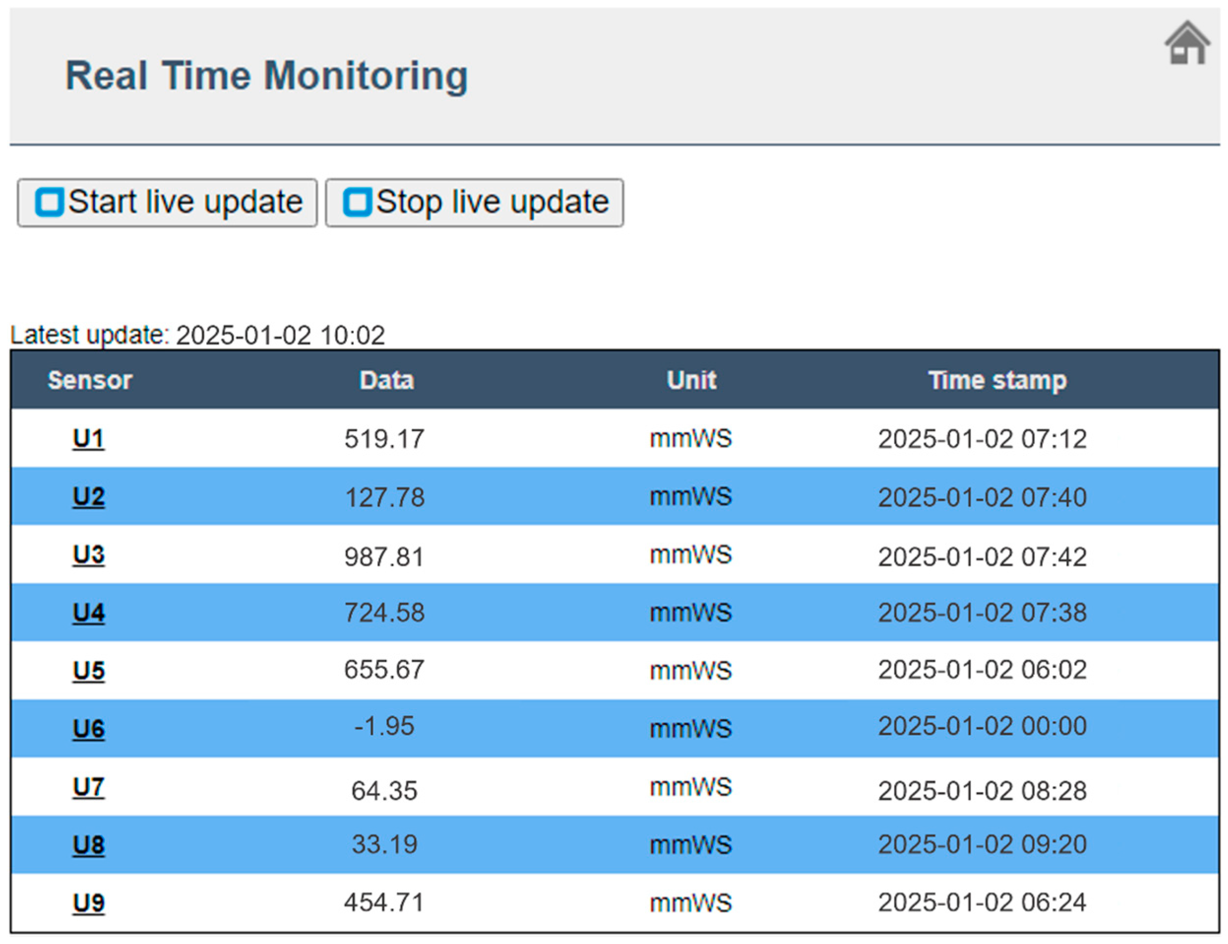
The sensor data requested via the function shown in Listing 1 is integrated into the digital twin environment. DESITE md allows the integration of individual webforms, designed to access the DESITE md API and enable functions beyond the standard scope of the software. Figure 6 provides an overview of the “Real-time Monitoring” webform embedded in DESITE md. The primary purpose of this webform is to display and contextualize sensor data within the digital twin environment. However, it should be noted that additional functionalities for validation, as described in Section 4.1, can be implemented if required.
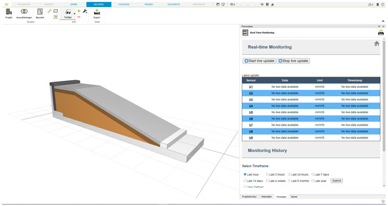
Figure 6.
Visual representation of the digital twin environment.
The sensor data visualization within the webform comprises two sections. The upper section displays real-time sensor data from each pressure sensor, interpreted as seepage level in mmWS (millimeters water column), in a table. The table is displayed in more detail in Figure 7. Upon loading the webform, an HTTP request is sent to retrieve the latest data from each sensor. Once the data is transmitted, the most recent data points are displayed. Each sensor name listed in the first column of the table in Figure 7 is linked to a corresponding sensor object within the digital twin, allowing each seepage level measurement to be contextualized based on its specific location. Activating the Start Live Update button triggers periodic updates of the table content whenever new sensor data is available within the data management module presented in Section 3.2.
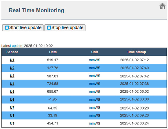
Figure 7.
Section of the webform in DESITE md containing the latest sensor data from each pressure sensor located in the dike.
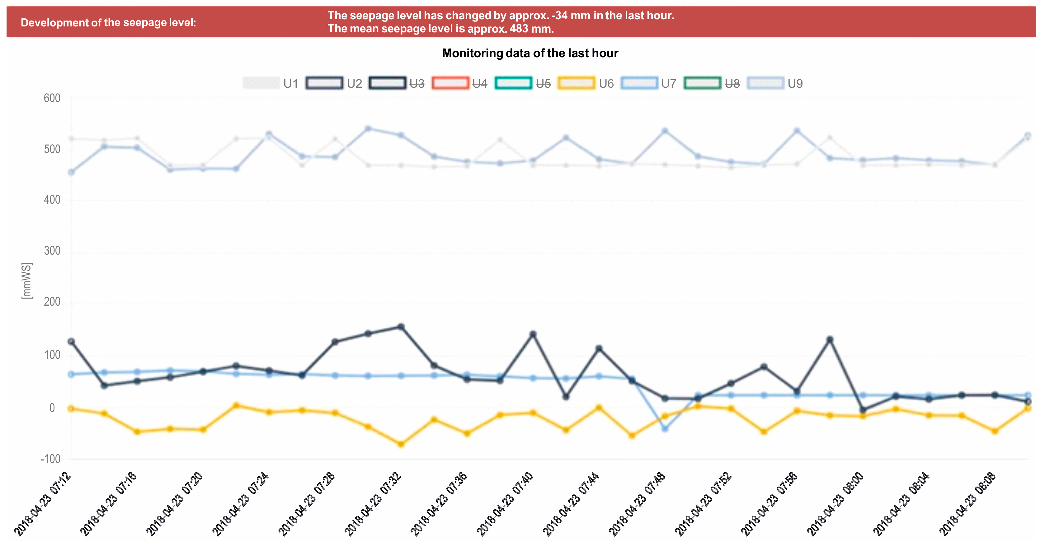
Below the table, a section for monitoring historical measurements is displayed (Figure 8). The graph in Figure 8 illustrates sensor data from pressure sensors U1, U2, U6, U7, and U9. For each timestamp on the horizontal axis, the height of the water column above the sensor is displayed in mmWS, reflecting the internal seepage level. Depending on changes in the seepage level, the box above the line graph signals a critical development (red background) or a normal development (green background), based on the exceedance of a predefined threshold.
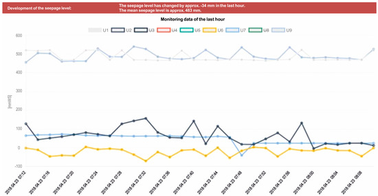
Figure 8.
Optimized line graph in DESITE md containing sensor data uploaded to the server in one hour.
Specifically, the requirements for enhancing maintenance through digital-twin-based SHM, as outlined in Section 2, are implemented via the webform solution in DESITE md. Sensor data from the nine pressure sensors belonging to the sensor network considered in this research is accessed through the Desite md API. The data transfer follows existing IoT standards by structuring the sensor data according to the OGC SensorThings data model and using standardized communication protocols. Within the digital twin environment, sensor data is linked to sensor objects to localize each data point, thereby enabling object-oriented data analysis.
4.3. Discussion of the Results
The validation shows that the digital-twin-based SHM approach is successfully implemented and can advantageously be used in a commercially available BIM software product. For example, using real-time sensor data, the as-is condition is monitored. By visualizing sensor data over specified timeframes, trends and condition changes that may indicate potential damage become apparent within the digital twin environment. In addition, condition assessment of the dike, such as damage developing over time, can be both detected and directly associated with a specific location within the structure. Focusing on a proof of concept for digital-twin-based SHM, a quantitative analysis of sensor data is not further discussed in this context. Considering the validation of communication paths and the integration of sensor data structured according to the OGC SensorThings data model, it could be shown that establishing communication between a digital twin environment and a sensor network is feasible with existing IoT standards. Executing on-demand requests or automated requests at predefined time intervals has proven to fulfill the requirements of right-time monitoring, in contrast to permanently receiving sensor data, which leads to performance issues in the digital twin environment. To further preserve the overall performance of the digital twin environment, eliminating the need for local storage capacity by linking sensor data from the external server is feasible, enhancing digital twin use cases, e.g., for government authorities, which frequently utilize commercial BIM management software.
Despite the success encountered in this study, room for future improvements has been identified. For example, automated early warnings for probable failure are limited. Nevertheless, model-based visualizations and linked sensor data provide a basis for improved decision-making regarding predictive maintenance. The data management concept developed in this study aims to enable a digitalized and automatically updated condition assessment, enhancing the currently used manual, non-digital damage documentation. To transfer the data management concept, currently proven on a demonstrator scale, into real-world applications, certain technical requirements must be considered. With a comprehensive monitoring strategy defined for a specific structure, the types and locations of sensors need to be predetermined. Furthermore, to minimize raw data volume, using smart sensor nodes connected to server systems through base stations—integrating multiple sensor types into a single unit and processing data on board—is advantageous. The need to reduce the amount of transferred data per single request also arises regarding the possible scope of sensor data that can be provided within a single request. In cases of very large dike structures, a reduction in data may be feasible using edge computing or automatic adjustments of data requests. For deployment in remote, outdoor locations, each node requires an alternative power source to ensure autonomous operation. Additionally, the sensor nodes need to be low-power and resilient to environmental impacts.
5. Summary and Conclusions
This research has been focusing on improving current maintenance for dikes using digital-twin-based SHM. The physical structure used to validate the proposed concept has been a sectional dike constructed under laboratory conditions. By measuring the internal pore water pressure via a sensor network, the internal seepage level has been derived. The sensor data has been successfully integrated into DESITE md, employed for setting up the digital twin environment via a tailor-made webform. The webform accesses the DESITE md API and establishes communication between the digital twin environment and the local data management module. The processed and aggregated sensor data is then linked to and visualized in the digital twin environment. The development of the measurements over time is displayed in a user-defined manner in the digital twin environment. The results of the validation corroborate that by including sensor data into a digital twin environment, the condition of the dike is assessable at any time, considering the initial status as well as changes over time. By designing and implementing the digital twin environment based on technical standards and well-established software tools, which enables condition assessment using sensor data, the workload required for conventional inspection processes is minimized, and decision-making regarding maintenance procedures is objectified. Also, anomalies and critical progression of sensor data that indicate damage are recognized at an early stage, facilitating predictive maintenance.
In conclusion, to bring digital-twin-based SHM into practice, pilot projects using dikes along coast or river lines are required. In future work, sensor networks implemented into geotextiles could be deployed to dikes within the scope of regular dike reinforcements. Digital twins created in such scenarios may include sensor data and be enriched with information stemming from manual, periodic inspections, or visual data collected from on-site cameras or satellite images. The potential of digital twins may be enhanced by establishing virtual interconnections between interdependent structures within a digital twin environment [41]. The interoperability enables the setup of a network of digital twins, which allows risk management considering dependencies with other flood protection structures or any twinned infrastructure. By creating digital twin environments with integrated sensor data, effective and predictive maintenance management is possible.
Author Contributions
Conceptualization, M.B. and M.H.; writing—original draft preparation, M.B.; writing—review and editing, K.S. and M.H.; supervision, G.Z.; project administration, M.H.; funding acquisition, M.H. and G.Z. All authors have read and agreed to the published version of the manuscript.
Funding
This research was conducted within the research project “Sensor- and BIM-based monitoring of hydraulic structures”, grant number 16KN093529, funded by the German Federal Ministry for Economic Affairs and Climate Action. The project is conducted by WTM Engineers GmbH, Gewecke Teamplan GmbH, as well as the Geodetic Institute and Chair for Computing in Civil Engineering & GIS (GIA) and the Institute of Hydraulic Engineering and Water Resources Management (IWW) at RWTH Aachen University.
Data Availability Statement
The datasets presented in this article are not readily available as they are part of an ongoing study. Requests to access the datasets should be directed to M.H.
Acknowledgments
The authors sincerely thank Holger Schüttrumpf and Maximilian Born from the Institute of Hydraulic Engineering and Water Resources Management (IWW) as well as Jörg Blankenbach, Ralf Becker, and Thomas Lemmerz from the Geodetic Institute and Chair for Computing in Civil Engineering & GIS (GIA) at RWTH Aachen University for providing access to the dike and to the corresponding sensor data from the sensor network deployed in this study.
Conflicts of Interest
M.B. and M.H. are employees and G.Z. is managing partner of WTM Engineers GmbH. The paper reflects the views of the scientists and not the company. The authors declare no conflicts of interest.
References
- Bergmeister, K.; Fingerloos, F.; Wörner, J.-D. (Eds.) Beton-Kalender 2013: Lebensdauer und Instandsetzung, Brandschutz; Ernst & Sohn: Berlin, Germany, 2013; pp. 345–468. ISBN 978-3-433-03000-4. [Google Scholar]
- van Noortwijk, J.M.; Frangopol, D.M. Two probabilistic life-cycle maintenance models for deteriorating civil infrastructures. Probabilistic Eng. Mech. 2004, 19, 345–359. [Google Scholar] [CrossRef]
- DIN 1076:1999-11; Ingenieurbauwerke im Zuge von Straßen und Wegen—Überwachung und Prüfung. Beuth: Berlin, Germany, 1999.
- Große, C.; Helmerich, R.; Herbrand, M. Dauerüberwachung von Ingenieurbauwerken—Merkblatt B09; Deutsche Gesellschaft für Zerstörungsfreie Prüfung e.V.: Berlin, Germany, 2022; ISBN 978-3-947971-22-0. [Google Scholar]
- Bergmeister, K.; Fingerloos, F.; Wörner, J.-D. (Eds.) Beton-Kalender 2015: Bauen im Bestand, Brücken; Ernst & Sohn: Berlin, Germany, 2013; pp. 317–458. ISBN 978-3-433-03073-8. [Google Scholar]
- Hofstede, J. (Ed.) Generalplan Küstenschutz des Landes Schleswig-Holstein; Ministerium für Energiewende, Landwirtschaft, Umwelt, Natur und Digitalisierung des Landes Schleswig-Holstein: Kiel, Germany, 2022; Available online: https://www.schleswig-holstein.de/DE/fachinhalte/K/kuestenschutz/generalplanKuestenschutz.html (accessed on 16 July 2025).
- Balageas, D.; Fritzen, C.P.; Guemes, A. (Eds.) Structural Health Monitoring; ISTE: London, UK, 2006; ISBN 978-1-905209-01-9. [Google Scholar]
- BAW Merkblatt Damminspektion (MDI); Bundesanstalt für Wasserbau: Karlsruhe, Germany, 2017.
- Noel, A.B.; Abdaoui, A.; Elfouly, T.; Ahmed, M.H.; Badawy, A.; Shehata, M.S. Structural health monitoring using wireless sensor networks: A comprehensive survey. IEEE Commun. Surv. Tutor. 2017, 19, 1403–1423. [Google Scholar] [CrossRef]
- Sofi, A.; Regita, J.J.; Rane, B.; Lau, H.H. Structural health monitoring using wireless smart sensor network–An overview. Mech. Syst. Signal Process. 2022, 163, 108113. [Google Scholar] [CrossRef]
- Smarsly, K.; Dragos, K.; Kölzer, T. Sensorintegrierte digitale Zwillinge für das automatisierte Monitoring von Infrastrukturbauwerken. Bautechnik 2022, 99, 471–476. [Google Scholar] [CrossRef]
- Kornblum, W.; Schumann, R. Digitale Zwillinge ermöglichen fundierte Entscheidungen durch vernetzte Daten. Bautechnik 2023, 100, 198–205. [Google Scholar] [CrossRef]
- Jiang, F.; Ma, L.; Broyd, T.; Chen, K. Digital twin and its implementations in the civil engineering sector. Autom. Constr. 2021, 130, 103838. [Google Scholar] [CrossRef]
- Torzoni, M.; Tezzele, M.; Mariani, S.; Manzoni, A.; Willcox, K.E. A digital twin framework for civil engineering structures. Comput. Methods Appl. Mech. Eng. 2024, 418, 116584. [Google Scholar] [CrossRef]
- Smarsly, K.; Ahmad, M.E.; Peralta, P.; Al-Zuriqat, T.; Al-Nasser, H.; Dragos, K.; Chillón Geck, C. Digital Twins, Architectures, and Elements in Civil Engineering—A Multivocal Literature Review. In Advances in Information Technology in Civil and Building Engineering: Proceedings of the 20th International Conference on Computing in Civil and Building Engineering (ICCCBE); Springer: Cham, Switzerland, 2025. [Google Scholar]
- Schmidt, C. (Ed.) Digitainability—Digital Technologies for Environmentally Sustainable Economic Activity: Market Potential and Strategic Implications (Acatech STUDY); Acatech–National Academy of Science and Engineering: Munich, Germany, 2023. [Google Scholar]
- Ariyachandra, M.R.M.F.; Wedawatta, G. Digital Twin Smart Cities for Disaster Risk Management: A Review of Evolving Concepts. Sustainability 2023, 15, 11910. [Google Scholar] [CrossRef]
- Yun, S.-J.; Kwon, J.-W.; Kim, W.-T. A Novel Digital Twin Architecture with Similarity-Based Hybrid Modeling for Supporting Dependable Disaster Management Systems. Sensors 2022, 22, 4774. [Google Scholar] [CrossRef]
- Wenner, M.; Meyer-Westphal, M.; Herbrand, M.; Ullerich, C. The Concept of Digital Twin to Revolutionise Infrastructure Maintenance: The Pilot Project smart-BRIDGE Hamburg. In Proceedings of the 27th ITS World Congress, Hamburg, Germany, 11–15 October 2021. [Google Scholar]
- Pregnolato, M.; Gunner, S.; Voyagaki, E.; de Risi, R.; Carhart, N.; Gavriel, G.; Tully, P.; Tryfonas, T.; Macdonald, J.; Taylor, C. Towards Civil Engineering 4.0: Concept, workflow and application of Digital Twins for existing infrastructure. Autom. Constr. 2022, 141, 104421. [Google Scholar] [CrossRef]
- Brucherseifer, E.; Winter, H.; Mentges, A.; Mühlhäuser, M.; Hellmann, M. Digital Twin conceptual framework for improving critical infrastructure resilience. Automatisierungstechnik 2021, 69, 1062–1080. [Google Scholar] [CrossRef]
- Hakimi, O.; Liu, H.; Abudayyeh, O.; Houshyar, A.; Almatared, M.; Alhawiti, A. Data Fusion for Smart Civil Infrastructure Management: A Conceptual Digital Twin Framework. Buildings 2023, 13, 2725. [Google Scholar] [CrossRef]
- Yu, D.; He, Z. Digital twin-driven intelligence disaster prevention and mitigation for infrastructure: Advances, challenges, and opportunities. Nat. Hazards 2022, 112, 1–36. [Google Scholar] [CrossRef]
- Cheng, R.; Hou, L.; Xu, S. A Review of Digital Twin Applications in Civil and Infrastructure Emergency Management. Buildings 2023, 13, 1143. [Google Scholar] [CrossRef]
- Doğan, Ö.; Şahin, O.; Karaarslan, E. Digital Twin Based Disaster Management System Proposal: DT-DMS. J. Emerg. Comput. Technol. 2021, 1, 25–30. [Google Scholar]
- Riaz, K.; McAfee, M.; Gharbia, S.S. Management of Climate Resilience: Exploring the Potential of Digital Twin Technology, 3D City Modelling, and Early Warning Systems. Sensors 2023, 23, 2659. [Google Scholar] [CrossRef] [PubMed]
- Henriksen, H.J.; Schneider, R.; Koch, J.; Ondracek, M.; Troldborg, L.; Seidenfaden, I.K.; Kragh, S.J.; Bøgh, E.; Stisen, S. A New Digital Twin for Climate Change Adaptation, Water Management, and Disaster Risk Reduction (HIP Digital Twin). Water 2023, 15, 25. [Google Scholar] [CrossRef]
- Blankenbach, J.; Gries, T.; Heins, K.; Herlé, S.; Ingebrandt, S.; Kimm, M.; Klopries, E.-M.; Schüttrumpf, H.; Wetzel, L. Sicherheit durch smarte Bauwerke. RWTH-Themen Forschungsmagazin 2021, 2021, 52–55. [Google Scholar]
- Dittmer, C.; Drews, K.; Eversheim, A. Governance und Kommunikation im Krisenfall des Hochwasserereignisses im Juli 2021; DKKV-Schriftenreihe Nr., 63; Deutsches Komitee Katastrophenvorsorge, e.V.: Bonn, Germany, 2024; ISBN 978-3-933181-73-2. [Google Scholar]
- Bersan, S.; Koelewijn, A.; Simonini, P. Application of distributed temperature sensors in piping-prone dikes. In FMGM 2015: Proceedings of the Ninth Symposium on Field Measurements in Geomechanics; Australian Centre for Geomechanics: Perth, Australia, 2015; pp. 475–486. [Google Scholar]
- de Vries, G.; Koelewijn, A.R.; Hopman, V. IJkdijk Full Scale Underseepage Erosion (Piping) Test: Evaluation of Innovative Sensor Technology. In Proceedings of the 5th International Conference on Scour and Erosion (ICSE-5), San Francisco, CA, USA, 7–10 November 2010; pp. 649–657. [Google Scholar] [CrossRef]
- Kuratorium für Forschung im Küsteningenieurwesen (Ed.) Die Küste—Entwicklung eines sensor- und risikobasierten Frühwarnsystems für Seedeiche—EarlyDike; Bundesanstalt für Wasserbau: Karlsruhe, Germany, 2021; Volume 90, ISBN 978-3-939230-78-6. [Google Scholar]
- Federal Waterways Engineering and Research Institute. MDI-DE—Marine Data Infrastructure Germany—Ocean Data. n.d. Available online: https://projekt.mdi-de.org/en/mdi-de-en/ (accessed on 7 October 2024).
- Federal Agency for Cartography and Geodesy. SDI Germany Geodateninfrastruktur Deutschland. n.d. Available online: https://www.gdi-de.org/GDI-DE (accessed on 7 October 2024).
- Federal Agency for Cartography and Geodesy. INSPIRE Geodateninfrastruktur Deutschland. n.d. Available online: https://www.gdi-de.org/en/INSPIRE (accessed on 7 October 2024).
- Assing, M.; Bange, M.; Bartsch, A.; Gutierrez, R.; Fritsch, D.; Hahn, O.; Harke, T.; Hartung, R.; Herbrand, M.; Käding, M.; et al. DBV Heft 51-Digitaler Zwilling: Strategie für den Bestandserhalt; Deutscher Beton- und Bautechnik Verein e.V.: Berlin, Germany, 2021. [Google Scholar]
- Lee, J.; Yoo, S.; Kim, C.; Sohn, H. Automatic levee surface extraction from mobile LiDAR data using directional equalization and projection clustering. Int. J. Appl. Earth Obs. Geoinf. 2023, 116, 103143. [Google Scholar] [CrossRef]
- Fritsch, C.; Voigt, C.; Burkhardt, J.; Arndt, R.; Marx, S. Digitale Bauwerksdiagnose—Ein Projekt zur digitalen Transformation. Bautechnik 2024, 3, 181–189. [Google Scholar] [CrossRef]
- Condemine, C.; Grau, L.; Masson, Y.; Aubry, S. Live Digital Twin for Hydraulic Structures Fatigue Estimation. In Proceedings of the PIANC Smart Rivers 2022; Springer Nature: Singapore, 2023; pp. 494–505. [Google Scholar]
- Brötzmann, J.; Grunert, G.; Thiele, C.-D.; Rüppel, U.; Lorenzen, S. BIM-Integration von Sensordaten aus dem Monitoring von Eisenbahnbrücken im Betrieb. Bautechnik 2024, 3, 166–173. [Google Scholar] [CrossRef]
- Cremona, C.; Santos, J. Structural Health Monitoring as a Big-Data Problem. Struct. Eng. Int. 2018, 28, 243–253. [Google Scholar] [CrossRef]
- Theiler, M.; Dragos, K.; Smarsly, K. BIM-based design of structural health monitoring systems. In Proceedings of the 11th International Workshop on Structural Health Monitoring (IWSHM), Stanford, CA, USA, 12–14 September 2017. [Google Scholar]
- buildingSMART: Industry Foundation Classes Version 4.1.0.0. 2020. Available online: https://standards.buildingsmart.org/IFC/RELEASE/IFC4_1/FINAL/HTML/ (accessed on 8 April 2025).
- Docker. Docker Desktiop: The #1 Containerization Tool for Developers. 2024. Available online: https://www.docker.com/products/docker-desktop/ (accessed on 2 January 2025).
- Chang, H.-F.; Shokrolah Shirazi, M. Integration with 3D Visualization and IoT-Based Sensors for Real-Time Structural Health Monitoring. Sensors 2021, 21, 6988. [Google Scholar] [CrossRef]
- DESITE BIM User Manual; Thinkproject Deutschland GmbH: Munich, Germany, 2023; Available online: https://focusbim.de/files/content/images/DESITE%20BIM/DESITE%20User%20Documentation_3.2.pdf (accessed on 16 July 2025).
- Fraunhofer Institute of Optronics, System Technologies and Image Exploitation FROST®-Server—An open source implementation of OGC SensorThings API. n.d. Available online: https://www.iosb.fraunhofer.de/en/projects-and-products/frost-server.html (accessed on 20 June 2024).
- SensorUp Inc. OGC SensorThings API Documentation. n.d. Available online: https://developers.sensorup.com/docs/ (accessed on 20 June 2024).


Disclaimer/Publisher’s Note: The statements, opinions and data contained in all publications are solely those of the individual author(s) and contributor(s) and not of MDPI and/or the editor(s). MDPI and/or the editor(s) disclaim responsibility for any injury to people or property resulting from any ideas, methods, instructions or products referred to in the content. |
© 2025 by the authors. Licensee MDPI, Basel, Switzerland. This article is an open access article distributed under the terms and conditions of the Creative Commons Attribution (CC BY) license (https://creativecommons.org/licenses/by/4.0/).