Article

Status Quo and Future Prospects of China’s Weather Routing Services for Ocean-Going Business Vessels

1
Merchant Marine College, Shanghai Maritime University, Shanghai 201306, China
2
National Meteorological Centre, China Meteorological Administration, Beijing 100081, China
3
Institute for Development and Programme Design, China Meteorological Administration, Beijing 100081, China
*
Authors to whom correspondence should be addressed.
Oceans 2025, 6(3), 38; https://doi.org/10.3390/oceans6030038
Submission received: 12 May 2025 / Revised: 16 June 2025 / Accepted: 18 June 2025 / Published: 23 June 2025

Abstract

The global shipping industry is evolving towards deep integration of digital transformation, intelligent upgrading, and green development. Meanwhile, recent geopolitical shifts have introduced heightened uncertainties into international shipping, compounding the challenges and escalating the demands for weather routing services for ocean-going ships. This paper provides a systematic review and expert perspective on China’s current status and key challenges in ocean-going weather routing services. Based on operational insights from China’s national meteorological service synthesized with a review of current trends and the literature, it further explores the future development of China’s ocean-going weather routing services and technologies from multiple dimensions: enhancing maritime weather observation capabilities, developing advanced weather routing service models, upgrading autonomous and controllable global satellite communication systems, promoting intelligent navigation technologies to facilitate shipping’s low-carbon transition, and expanding meteorological support capabilities for Arctic shipping routes. The analysis identifies critical gaps and proposes strategic directions, offering a unique contribution to understanding the trajectory of weather routing services within China’s specific national context from the perspective of its primary national service provider.

1. Introduction

Ocean-going ship weather routing is a navigation service designed to optimize voyage planning by leveraging forecasted sea conditions along the route or within a specific navigation area, in conjunction with the vessel’s performance characteristics. Its primary objective is to determine an optimal route that avoids adverse wind and wave zones, thereby minimizing voyage distance and duration, reducing fuel consumption, and enhancing operational efficiency and safety. The modern concept of ship weather routing originated in the early 1950s when the United States Navy first introduced it as a navigational strategy. The U.S. Navy, along with several private commercial navigation organizations, began utilizing surface and upper-air weather forecasts to assist transatlantic vessels in avoiding hazardous weather conditions. This approach not only improved navigational safety but also enhanced the economic efficiency of voyages [1,2]. Subsequently, countries such as the United Kingdom, the Netherlands, the former Soviet Union, Norway, and Japan established their own weather routing institutions, further advancing the field.
In 1983, the International Maritime Organization (IMO) adopted Resolution A.528(13) on the Recommendation on Weather Routing, which encourages vessels to utilize weather routing services to determine the optimal route, thereby avoiding severe weather conditions and enhancing navigational safety. The resolution also recommends that governments advise ships flying their flags about the availability of weather routing information, particularly those services recognized by the World Meteorological Organization (WMO) [3].
With the expansion of global trade, emissions from the shipping industry have been increasing annually. Statistics indicate that shipping accounts for approximately 3% of global carbon emissions [4]. Therefore, reducing carbon dioxide (CO2) emissions in the shipping industry is essential for achieving global climate targets. In recent years, the International Maritime Organization (IMO) has introduced a series of policies and technological measures to drive the green transition of the shipping industry. Annex VI of the International Convention for the Prevention of Pollution from Ships (MARPOL) establishes specific targets and pathways for reducing ship carbon emissions through mechanisms such as the Energy Efficiency Design Index (EEDI), the Ship Energy Efficiency Management Plan (SEEMP), and Carbon Intensity Indicators (CII) [5]. To support emission reduction, the IMO has recommended various measures focusing on technology, operations, and ship design. Among these, weather routing services play a crucial role by optimizing ship speed and routes. Route optimization alone can potentially reduce carbon emissions by up to 10%, while optimized speed management, often integrated within weather routing, can contribute significantly more, with combined strategies potentially achieving emission reductions in the range of 5–20% or higher depending on the voyage and vessel specifics [6,7,8].
Marine meteorological observation and forecasting capabilities are fundamental to ocean-going ship weather routing services. In recent years, advancements in China’s meteorological satellite technology (e.g., the Fengyun series) and the continuous development of numerical weather prediction (NWP) systems [9], particularly with the implementation of the National Marine Meteorological Support Project [10], have significantly enhanced the country’s marine meteorological observation, forecasting, and service capabilities. This progress has accelerated development and strengthened the competitiveness of China’s national ship weather routing services.
Additionally, leading international numerical forecasting agencies have progressively adopted open data policies [11]. Meanwhile, some private organizations acquire meteorological data from national meteorological agencies through collaboration and transactions, thereby lowering barriers to data access for ocean-going ship weather routing services. Furthermore, the widespread adoption of artificial intelligence (AI) has reduced traditional weather routing services’ reliance on large numbers of professional forecasters and captains, further decreasing operational costs for service providers and fostering the expansion of such institutions globally, including in China.
Globally, numerous studies have reviewed aspects of weather routing, focusing on optimization algorithms [12,13], specific regional challenges [14,15] or the impact of routing on fuel efficiency and emissions [16,17]. Several large private companies dominate the international market, offering sophisticated services built on decades of experience and technological investment (see Section 2). However, while these studies and services provide a global context, there is a noticeable gap in the literature regarding a systematic analysis of the current status, specific challenges, and future development trajectory of weather routing services within China.
In recent years, international trade disputes and geopolitical shifts have introduced greater challenges and uncertainties to global shipping. Consequently, China has placed significant emphasis on enhancing the safety of ocean shipping and strengthening its weather routing service capabilities. In the Meteorological High-Quality Development Outline (2022–2035), issued by the State Council of the People’s Republic of China in 2022, the improvement of marine meteorological forecasting and shipping meteorological services was explicitly highlighted as a priority [18]. Key initiatives include strengthening ship-based observation capabilities, promoting interdepartmental data sharing, advancing high-precision marine meteorological forecasting systems, and enhancing early warning mechanisms for marine meteorological disasters. These efforts aim to establish a robust and independent weather routing service framework to ensure the safety and efficiency of vessel operations. Understanding the current state and future needs of China’s weather routing services is therefore crucial, given China’s vast maritime fleet, its central role in global trade, the unique characteristics of its national service provision model, and its stated national strategic goals.
This paper aims to fill this gap by providing a comprehensive review of China’s weather routing services. It analyzes the current status, identifies key challenges and technical constraints from the operational perspective of the national service provider (the National Meteorological Centre, NMC), and presents an outlook on future development. The primary contribution of this work lies in its systematic analysis focused specifically on the Chinese context, offering insights based on direct operational experience. By identifying specific weaknesses and outlining targeted development pathways, this paper serves as a valuable reference for policymakers, service providers, and the international maritime community interested in the evolution of these critical services in a major maritime nation.
This paper adopts a qualitative review methodology combined with expert perspective analysis to assess the status quo, challenges, and future prospects of China’s ocean-going weather routing services. Recognizing that this work is an analytical review rather than original empirical research, this approach integrates insights from three distinct categories of sources:
Published Literature and Industry Information: A targeted review of international and domestic scientific papers, technical reports, conference proceedings, and reputable industry publications was conducted over no specific time period to gather foundational knowledge. This provided context on weather routing principles, global best practices, technological advancements (e.g., algorithms [19,20,21], AI applications [22], low-carbon technologies [23,24]), international market leaders [25], and general challenges faced by the industry worldwide (e.g., observation gaps [26,27,28], modeling difficulties [29,30,31,32], communication constraints [33]).
Official Policy Documents and National Reports: Key Chinese government policy documents were analyzed to understand the strategic priorities and official objectives related to maritime meteorology. Crucially, the “Meteorological High-Quality Development Outline (2022–2035)” and analyses of the “National Marine Meteorological Support Project” provide authoritative context for national goals, framing the assessment of challenges (Section 3) and the rationale behind future prospects (Section 4).
Operational Expertise and Internal Documentation: As frontline operational and research personnel at the National Meteorological Centre (NMC), the authors possess direct, long-term experience with the development, implementation, and daily operation of China’s primary national weather routing service. This “insider perspective” provides unique insights into specific operational workflows, historical context (e.g., CMRC transition, NMC service relaunch), internally developed technologies (e.g., speed loss algorithms, typhoon avoidance methods [34]), specific challenges encountered in the Chinese context (e.g., integration of domestic NWP models), and internal strategic considerations for future development.
The analysis presented in Section 2, Section 3 and Section 4 represents a synthesis of these three information streams. We explicitly acknowledge that insights derived from operational experience are not as verifiable as peer-reviewed publications. However, excluding this perspective would result in an incomplete picture. By clearly identifying the authors’ affiliation and integrating this expert perspective with verifiable public sources, this paper aims to provide a uniquely valuable and nuanced understanding of China’s weather routing services.
We explicitly acknowledge that insights derived from operational experience and internal documentation lack the direct verifiability of peer-reviewed publications or publicly released datasets. This is an inherent limitation when reviewing the specific status and strategy of a national operational entity. However, we argue that excluding this perspective would result in an incomplete and potentially misleading picture, reliant solely on the generic global literature or high-level policy statements. By clearly identifying the authors’ affiliation and integrating this expert perspective with verifiable public sources, this paper aims to provide a uniquely valuable and nuanced understanding of China’s weather routing services, contributing practical insights relevant to researchers, industry stakeholders, and policymakers interested in this specific and globally significant maritime context.

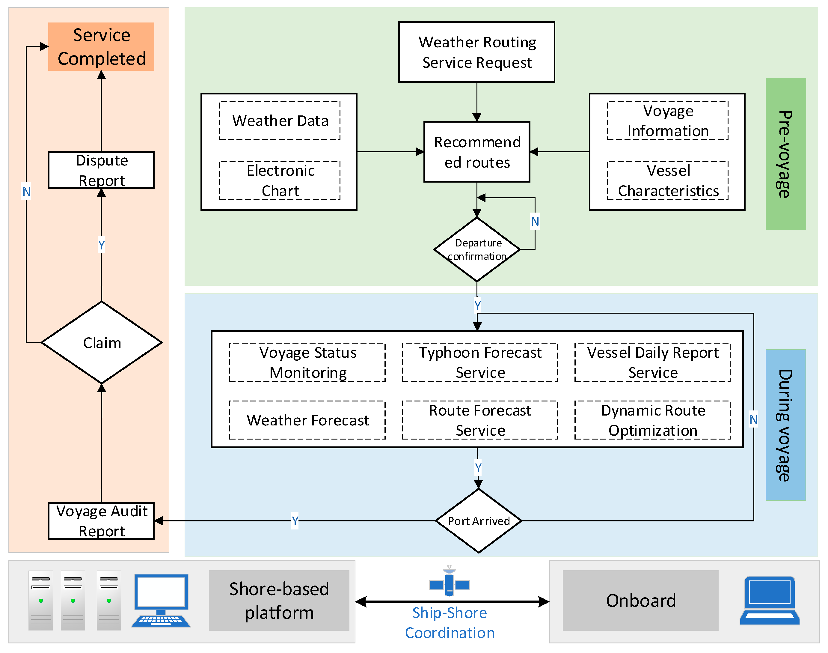
2. Current Status of Ocean-Going Ship Weather Routing Services

This section reviews the current status, focusing primarily on the national service provider (NMC) due to data availability and its central role, while also acknowledging other key players in the Chinese market. The world’s major shipping routes are highly interconnected, linking key ports across continents. As shown in Figure 1, these routes form the arteries of international trade. The fundamental objective of ship weather routing services is to provide vessels with accurate weather forecasts during navigation. This ensures maritime safety while minimizing operational costs and carbon emissions, contributing to the development of green shipping. Globally, the primary users of ship weather routing services typically include shipowners and charterers (i.e., lessees of vessels). The specific services provided vary depending on contractual agreements and operational needs. Under the framework of a charter party, particular emphasis is placed on analyzing ship sailing data and assessing ship performance throughout the voyage. At the end of the voyage, a comprehensive audit report is compiled, incorporating the vessel’s trajectory and prevailing weather conditions. This report serves as essential documentation for resolving potential speed claims, shipping disputes, or contractual disagreements related to the charter party.
Most of the world’s leading ocean-going weather routing companies are privately owned enterprises based abroad, such as Weather News Inc. (WNI) from Chiba, Japan, StormGeo (Bergen, Norway), Weather Routing Inc. (Glens Falls, NY, USA), and True North Marine (Montreal, QC, Canada) [25]. These companies have a long-established history and have developed comprehensive business systems and technological infrastructures through business expansion and mergers and acquisitions. As a result, they dominate more than 90% of the global weather routing service market.
As a leading enterprise in international weather routing services, WNI, headquartered in Japan, serves as a representative example for comparison due to its market leadership and publicly available service information, though a direct comparison of proprietary algorithms is not possible. It has a history spanning over 50 years since its establishment. WNI offers a wide range of services, including
  • Ship Route Optimization: Providing safe and economical route optimization based on vessel characteristics and weather forecasts, including the fastest arrival route, lowest fuel consumption route, fixed-time arrival route, and the safest route.
  • Pre-arrival Services: Advising vessels on optimal route planning 3–5 days before arrival to efficiently manage fuel consumption and scheduling.
  • Vessel Performance Monitoring: Conducting real-time analysis of vessel performance and generating interim audit reports. Upon voyage completion, a comprehensive performance assessment is provided, including time loss and fuel consumption analysis. In case of disputes, these reports serve as supporting evidence for claims and legal proceedings.
  • Carbon Emission Monitoring: Utilizing ship and fleet data to calculate CO2 emissions and assess the Energy Efficiency Operational Index (EEOI) for the entire fleet.
WNI acquires extensive meteorological and oceanographic observation data through collaborations with public institutions, private enterprises, and its clients/members. To further enhance its data capabilities, WNI has developed and launched multiple small observation satellites to support its weather routing services [35]. In 2006, the company established the Global Sea Ice Center to monitor sea ice dynamics and support Arctic weather routing. Additionally, WNI has advanced numerical weather forecasting through refined interpolation and interpretation techniques, AI-driven forecasting systems, and a suite of weather routing tools and software, thereby strengthening its weather routing services. In recent years, to improve shipping efficiency and optimize port operations, WNI has developed the Berth Waiting Forecast, a system designed to predict port congestion and capacity by incorporating weather factors alongside port operational efficiency. This service, as an extension of ocean-going weather routing, has been widely acclaimed by clients.
WNI’s Marine Division operates on a global scale, providing marine meteorological services to over 10,000 vessels annually. Since its establishment over five decades ago, the company has supported more than one million voyages. In addition to ocean-going weather routing services, WNI extends its meteorological services to offshore oil and gas exploration, marine engineering operations, and oceanic fisheries. In 2023, the Marine Division reported a sales revenue of 5.813 billion JPY (approximately 270 million CNY), contributing approximately 26% to the company’s total revenue.
Although initially specializing in ocean-going weather routing, WNI has continuously expanded its scope in response to advancements in meteorological science and evolving societal demands. The company has since extended its services to include aviation meteorology, environmental meteorology, sports meteorology, and media services, such as television broadcasting and mobile/internet-based meteorological applications. As part of its global expansion strategy, WNI currently operates thirty-two offices across twenty-one countries and maintains five service centers worldwide, further consolidating its position as a leading provider of meteorological solutions.
In China, the development of weather routing services has followed a different path, largely driven by national meteorological institutions. In the mid-to-late 1980s, the National Meteorological Center (NMC) of the China Meteorological Administration initiated ocean-going weather routing services. Subsequently, in 1993, it established a joint venture with a subsidiary of China Ocean Shipping Company (COSCO) through the founding of Beijing Globe Mertroute Technology Co., Ltd. (hereafter referred to as “CMRC”). This strategic move positioned CMRC as one of the three dominant entities in China’s weather routing market at that time, alongside American and Canadian companies then operating in China. During this period, the company achieved notable economic benefits through effective market competition. However, a pivotal organizational transition occurred in 2003 when CMRC underwent equity restructuring, transitioning from a joint venture to a wholly state-owned enterprise under the NMC. From 2005 onward, based on internal assessments and operational records, the company experienced progressive contraction at the operational scale, culminating in near-complete operational stagnation. This decline precipitated the loss of both domestic and international market presence, accompanied by technological stagnation in weather routing systems and software development. Consequently, CMRC forfeited key opportunities for continuous innovation and international competitiveness within the weather routing sector, ultimately resulting in the discontinuation of its continuous development trajectory.
In 2017, the NMC collaborated with Huayang Maritime Center under the Ministry of Transport of China to reestablish its ocean-going weather routing service team. Through systematic technological advancements and market promotion initiatives, the center officially launched its independently developed weather routing system in 2019 [36].
Supported by the data and technical expertise of the China Meteorological Administration, and benchmarked against international weather routing service standards, the NMC constructed a shore-based integrated service platform and onboard service terminals utilizing next-generation information technologies. As shown in Figure 2, the shore-based platform integrates global weather observations/forecasts, electronic navigational charts, and shipping data to generate and recommend optimal initial routes through routing optimization algorithms. Upon voyage commencement, satellite-enabled bidirectional communication ensures real-time data synchronization between the shore-based platform and onboard terminals. This system delivers warnings for extreme weather events (e.g., typhoons, sea fog, and extratropical cyclones) by synthesizing real-time meteorological/hydrological data with numerical model forecasts. Concurrently, it dynamically updates optimal routes based on the latest forecasts of wind, waves, and currents. Post voyage, the platform conducts comprehensive evaluations of vessel performance throughout the voyage. In cases of disputes such as speed-related claims, it generates objective voyage audit reports with defensible evidence and recommendations, providing critical support for insurance settlements or arbitration proceedings. This closed-loop workflow—pre-voyage planning, during-voyage services, post-voyage evaluation, and dispute resolution—maximizes navigational safety and operational efficiency. Furthermore, the NMC developed a cloud-based weather routing service platform and mobile application system to enhance system stability and streamline service accessibility for client requests and real-time vessel status monitoring.
To enhance the core technical capabilities of weather routing services, the NMC has conducted research on ship speed loss, developing three empirical algorithms for conventional vessel types. These algorithms have been integrated into weather route recommendation products to quantitatively assess the impacts of weather conditions on vessel performance. Concurrently, the NMC established a typhoon avoidance methodology and segmented avoidance strategies through the analysis of typhoon observations, track/intensity forecasts, and forecast error statistics. This framework optimizes navigation time by treating vessel speed and heading as variables, constrained by the minimum encounter distance between vessels and typhoon centers [34]. Furthermore, the NMC implemented a navigation risk forecasting system that evaluates voyage risks based on hydrometeorological parameters (e.g., wind, waves, swells, currents) combined with vessel-specific characteristics. The system generates risk visualization products to inform route planning and adaptive navigation strategies.
Since relaunching its weather routing services in 2019, the NMC has served over 20,000 vessels. While NMC represents the primary national provider, other Chinese companies are also active in the market. These include Shanghai Haiyang Weather Routing Technology Co., Ltd. (Shanghai, China), Wuxi Ninecosmos Science And Technology Co., Ltd. (Wuxi, China), and Shanghai Maili Marine Technology Co., Ltd. (Shanghai, China) [25]. These private or semi-private entities are expanding their influence in domestic and international markets, often offering specialized weather routing solutions or focusing on specific market segments, thus contributing to the overall development of China’s weather routing capabilities. However, detailed public information on the specific market shares and technical capabilities of these private providers remains limited.

3. Challenges in China’s Weather Routing Services

While China has made significant progress in weather routing services in recent years, notable gaps persist compared to the benchmark set by leading international providers and forecasting centers. The global shipping industry is evolving toward deep integration of digital transformation, intelligent upgrading, and green development, which imposes heightened demands on ship weather routing technologies. Systematically addressing the persisting gaps and weaknesses in China’s ocean-going weather routing services holds critical importance for advancing core technical capabilities and ensuring competitiveness in this transformative landscape.

3.1. Insufficient Marine Meteorological Observation Capabilities

Marine meteorological observation serves as the foundational pillar for weather routing services. Currently, China faces significant deficiencies in marine meteorological observation infrastructure. The existing network of observation stations—including buoys, offshore platforms, island-based stations, and sea-based installations—remains sparse, with most concentrated within 100 nautical miles of China’s coastal waters [28]. Critical global shipping routes, major ports (e.g., the Strait of Malacca, Suez Canal), Arctic routes, and key oceanic regions exhibit extensive observational gaps. The consequences of such gaps can be significant; for example, undetected rapidly developing localized storms or inaccurate sea-state forecasts due to data gaps in busy lanes like the Malacca Strait could lead to unexpected vessel damage, cargo loss, or significant delays, impacting supply chain reliability. While approximately 8000 global marine observation platforms (e.g., international Voluntary Observing Ships, buoys) are accessible via the Global Telecommunication System (GTS), these data remain insufficient in terms of spatial continuity, temporal resolution, and observational synchronicity. Recent advancements in satellite remote sensing—such as China’s FY (Fengyun) series, the U.S. GOES, and Europe’s MeteoSat—have provided indispensable support for monitoring tropical cyclones, sea fog, surface winds, and polar sea ice. However, most satellites lack direct quantitative observation capabilities. Satellite-derived data cannot substitute in situ measurements due to limitations in spatial resolution, retrieval inaccuracies, and inadequate temporal coverage [37].
Ocean-going vessels are typically equipped with onboard meteorological instruments, and real-time acquisition of their observational data could effectively supplement existing systems through programs like the Voluntary Observing Ship (VOS) scheme [38]. However, operational challenges persist. Anecdotal reports and operational experience suggest that some nations frequently detain vessels carrying meteorological sensors or restrict port access under the excessive invocation of national security concerns. Consequently, ship captains widely resist installing automated weather stations with telecommunication modules, citing privacy and operational risks.

3.2. Challenges in Ocean-Atmosphere Coupled Numerical Forecasting Capabilities

Numerical forecasting products constitute the cornerstone of weather routing services. China has established a relatively comprehensive numerical weather prediction (NWP) system for meteorology and oceanography, significantly enhancing the timeliness, precision, and objectivity of weather routing services, thereby laying the groundwork for autonomous core technologies. However, notable gaps persist compared to leading international centers such as the European Centre for Medium-Range Weather Forecasts (ECMWF) and the National Centers for Environmental Prediction (NCEP) of the US National Weather Service, particularly in spatiotemporal resolution and forecast accuracy [39]. For instance, inaccuracies in forecasting the intensity or track of extratropical cyclones in the North Atlantic could lead vessels into dangerously high sea states, compromising safety and potentially causing structural damage.
Additionally, China’s meteorological and oceanic numerical models have historically been developed independently, with coupled atmosphere–ocean modeling initiatives lagging behind global advancements [40,41]. The maturity of coupled modeling techniques—such as integrated atmosphere–ocean–wave–ice systems—remains relatively low within China’s operational systems, resulting in suboptimal stability and accuracy of coupled models. Although China has increased investments in marine meteorological numerical modeling through national projects in recent years, critical gaps persist in refining physical parameterizations and advancing data assimilation. For instance, challenges include limited assimilation of satellite-derived observations and sparse integration of multi-source oceanic data (e.g., buoy and submersible measurements) [42,43].

3.3. Limitations in Accurate Prediction of Ship Speed Loss

Ship speed loss prediction is a critical technical challenge in weather routing services, serving as the foundation for vessel position estimation and optimized weather routing. While this is a global challenge, its impact in China is shaped by the specific models and data available domestically. Ship speed reduction primarily occurs under two scenarios: (1) voluntary speed reduction by captains to ensure safety during vessel or cargo emergencies, and (2) involuntary speed loss caused by additional resistance from hydrometeorological factors (e.g., wind, waves, currents), potentially leading to operational stagnation. Current methodologies for ship speed loss modeling are categorized into three approaches: theoretical models [32], empirical formulas [44], and machine learning (ML)-based frameworks [45]. Researchers are refining prediction accuracy and applicability through advancements in empirical formula optimization, computational fluid dynamics (CFD), and hybrid data model-driven strategies. The integration of artificial intelligence (AI) has enabled ML models to capture complex nonlinear relationships and high-dimensional data.
However, even for vessels of the same class, prediction accuracy varies significantly due to operational heterogeneity, including differences in vessel age, cargo load, and hull fouling levels. While vessel-specific models can enhance accuracy, acquiring and processing high-quality datasets remains a major bottleneck for most ships. Furthermore, due to the scarcity of navigation data under severe sea conditions, model performance degrades markedly in extreme weather scenarios. These limitations directly impact the reliability of Estimated Time of Arrival (ETA) calculations and the effectiveness of route optimization provided by Chinese services.

3.4. Deficiencies in Maritime Communication Capabilities

Under current maritime communication infrastructure, real-time data exchange between vessels and shore-based systems heavily relies on commercial satellite networks dominated by international providers [36]. While a global challenge, China’s reliance on potentially foreign-controlled networks presents specific strategic considerations. Furthermore, bandwidth constraints of these traditional GEO/MEO maritime satellites severely limit data transmission capacity and service scope for weather routing [46]. In operational workflows, shipborne weather routing terminals transmit route-specific weather forecasts and onboard observational data to shore-based platforms via satellite links. Due to limited bandwidth, these datasets must undergo compression or thinning prior to transmission. For instance, acquiring 7-day, 3-hourly weather forecasts for a 10° × 10° maritime area at a 0.1° × 0.1° spatial resolution generates approximately 40 MB of data, with single-transmission costs using traditional systems potentially exceeding hundreds of USD. While emerging Low Earth Orbit (LEO) satellite constellations (e.g., Starlink Maritime) promise higher bandwidth and potentially lower costs, their widespread adoption on commercial vessels, consistent global coverage, and proven reliability for critical services are still evolving [47]. Consequently, most ocean-going vessels currently restrict data transmission volumes and frequencies, typically by degrading the spatiotemporal resolution of meteorological products. Such compromises inevitably reduce data granularity, undermining the accuracy and real-time responsiveness of weather routing services. Moreover, vessel-collected observational data hold significant potential for addressing marine observational gaps, enriching oceanic datasets, and enhancing numerical forecasting accuracy. However, the transmission of these data remains constrained by the bandwidth limitations and prohibitive costs of prevalent maritime satellite networks, severely hindering their full utilization in operational and research contexts.

3.5. Inadequate Capabilities in Ship Navigation Risk Identification and Precision Forecasting

Hydrometeorological conditions significantly impact maritime safety, with severe weather events (e.g., typhoons, extratropical cyclones, dense fog) posing risks of speed loss, maneuvering difficulties, and collisions. Accurate risk identification is a universal challenge, but its implementation in China depends on integrating domestic forecast data and potentially specific regulatory requirements. Current navigation risk forecasting methods, predominantly based on the IMO MSC.1/Circ.1228 Revised Guidelines for the Avoidance of Dangerous Situations in Adverse Weather and Sea Conditions [48], evaluate risks such as parametric rolling, synchronous rolling, successive high wave attack, surf-riding and broaching-to using static vessel parameters combined with wave height, period, and direction. However, this framework lacks the comprehensive integration of dynamic vessel parameters, limiting its predictive accuracy and operational utility.
Under wind–wave–current interactions, vessels exhibit coupled dynamic responses—including rolling, pitching, yawing, surging, swaying, and heaving—that induce instability. These responses are further complicated by navigational factors such as channel width and traffic density, exacerbating the challenges in risk identification. To address these limitations, a holistic risk assessment framework must be developed, integrating vessel-specific characteristics (static and dynamic parameters, as outlined in Table 1), motion response dynamics, and hydrometeorological conditions. Recent research has made significant strides in this area, particularly in modeling synchronous and parametric roll and developing more comprehensive risk assessment frameworks [29,30]. Such a model would provide robust scientific support for adaptive route/speed adjustments and extreme weather avoidance.

4. Future Prospects for China’s Weather Routing Services

4.1. Enhancing Marine Meteorological Observation Capabilities

Marine meteorological and oceanographic data are essential for weather routing services, and the capability for marine meteorological observation serves as a critical indicator of a nation’s comprehensive maritime competence, as emphasized in national strategies [10,18]. China must continuously enhance its marine meteorological observation capabilities by optimizing existing coastal and nearshore observation infrastructure—such as established land-based meteorological stations, coastal radars, buoys, and vessel-based systems—while progressively extending observational coverage to remote oceanic zones and global maritime corridors using various platforms including Voluntary Observing Ships (VOSs), floats, gliders, and advanced remote sensing technologies. This expansion should integrate manned and unmanned aerial systems to establish agile, mobile meteorological observation capacities. The focus remains on improving data collection for meteorological forecasting and maritime safety in line with international practices and national development goals.
Efforts should also focus on advancing satellite-based monitoring of marine meteorology through the development of next-generation satellite payloads (e.g., advanced sensors for sea surface temperature and wind retrieval) and improving the validation and application of global ocean surface products derived from meteorological satellites [37]. A three-dimensional, intelligent, and integrated marine meteorological observation system—combining sea-based, air-based, and space-based platforms—must be independently developed and deployed. This system should gradually achieve comprehensive coverage of key regions, including the Maritime Silk Road and Arctic shipping routes, ultimately extending to global waters to provide robust support for international marine meteorological monitoring, forecasting, and weather routing services. Achieving this vision faces significant barriers, including the high costs of deploying and maintaining infrastructure in harsh marine environments, logistical challenges in remote areas, and the need for sustained international cooperation in data sharing and platform deployment.
Additionally, private capital should be encouraged to participate in the construction of marine meteorological observation infrastructure. Governments or enterprises could procure observation services through public–private partnerships (PPPs) to achieve mutually beneficial outcomes [49]. Furthermore, broader international collaboration—such as sharing marine meteorological data with global institutions (e.g., WMO Integrated Global Observing System—WIGOS) and other nations—should be pursued to diversify data sources and enhance observational completeness.

4.2. Development of a Weather Routing Service Based on Large-Scale AI Models

The rapid advancement of artificial intelligence (AI) technology is poised to drive the intelligent transformation of weather routing services. By integrating domain-specific knowledge from ship meteorological navigation services, large-scale AI models (e.g., foundation models adapted for spatio-temporal forecasting, deep learning techniques like Graph Neural Networks or Transformers) can significantly enhance the intelligence level of weather routing systems [50,51]. The AI-based weather routing service model synthesizes meteorological and oceanographic observations, global numerical weather forecasts, real-time ship AIS (Automatic Identification System) dynamics, and historical voyage databases to construct a spatiotemporal feature fusion framework. This framework establishes a multi-dimensional situational awareness system that integrates global hydrometeorological conditions, ship route monitoring, and historical navigation patterns.
Furthermore, advanced weather routing systems can incorporate a shipping accident knowledge graph and a natural language processing (NLP) module capable of real-time parsing of maritime notices (e.g., NAVTEX, Notices to Mariners) issued by nations worldwide [52]. By correlating this information with ship navigation data, the model achieves dynamic risk perception and voyage risk early warning, enabling proactive adjustments to ensure maritime safety and operational efficiency. This integrated approach not only optimizes route planning under complex hydrometeorological conditions but also provides a scalable, cost-effective solution for advancing intelligent maritime navigation in the era of AI-driven innovation.
However, realizing this potential requires overcoming barriers such as ensuring sufficient high-quality training data, addressing model interpretability and reliability concerns, and integrating complex AI models with existing operational systems.

4.3. Enhancing China’s Global Satellite Communication Capabilities

To strengthen China’s self-reliance in satellite communications, efforts should prioritize accelerating the construction of indigenous communication satellite constellations to improve global coverage. Concurrently, the development of satellite internet infrastructure and the collaborative establishment of satellite relay transmission and reception stations with partner nations will reduce dependency on foreign satellite communication systems. Additionally, the BeiDou-3 Navigation Satellite System should be further integrated into global meteorological data transmission and weather routing services [53]. Enhancing data transfer capabilities between Fengyun geostationary and polar-orbiting meteorological satellites will provide innovative solutions for transmitting data from deep-sea buoys, ocean-going vessels, and other remote maritime assets. The intended benefits of these enhancements include significantly increased data transmission bandwidth, enabling higher resolution forecasts and more frequent updates onboard, reduced latency for real-time decision support, improved coverage, particularly in polar regions and remote oceanic areas currently underserved by some commercial systems, enhanced system resilience and autonomy, and potentially lower communication costs for Chinese-flagged vessels in the long term.
To optimize technical performance, advancements in data transmission technologies are critical. Research on lossless data compression methods tailored for weather routing services will improve data accuracy and real-time processing efficiency, thereby elevating the precision and timeliness of weather routing guidance. Significant investment in satellite development and ground infrastructure, international coordination for spectrum allocation, and robust cybersecurity measures represent key challenges to achieving these goals.

4.4. Intelligent Weather Routing Technology to Empower Low-Carbon Transition in Shipping

The global shipping industry’s commitment to carbon reduction policies, particularly under the IMO’s greenhouse gas (GHG) emission strategy [4], has created multidimensional opportunities for advancing ship weather routing technologies. As vessel operators increasingly prioritize energy efficiency optimization, intelligent weather routing systems are emerging as a transformative solution. These systems directly contribute to meeting IMO targets (e.g., EEXI, CII) by enabling vessels to continuously optimize their route and speed based on real-time weather, currents, and vessel performance models, thereby minimizing fuel consumption and associated emissions [14]. Future systems may incorporate advanced algorithms, such as deep reinforcement learning (DRL), for dynamic route planning that balances fuel economy, carbon intensity, and safety.
The convergence of intelligent weather routing with emerging low-carbon technologies is driving a paradigm shift in maritime decarbonization. Centered on real-time meteorological sensing, these systems synergize with wind-assisted propulsion systems and low-carbon fuel technologies to establish a closed-loop framework: environmental energy harvesting, power configuration optimization, and emission control. Leveraging precise marine weather predictions, weather routing algorithms dynamically adjust parameters such as the angle of attack of wind sails and the power output of clean energy engines, enabling vessels to achieve dual breakthroughs in speed optimization and energy efficiency enhancement under complex sea conditions [54]. This integration not only transforms meteorological factors into actionable navigational resources but also provides critical technical support for achieving IMO’s decarbonization targets through the synergy of intelligent routing and clean energy systems. Barriers include the development of accurate digital twins for diverse vessels, reliable sensor integration for performance monitoring, and the cost associated with implementing compatible technologies onboard.

4.5. Expanding Arctic Weather Routing Service

Recent geopolitical shifts have heightened uncertainties in global shipping networks, with escalating tensions along traditional chokepoints such as the Strait of Malacca, Suez Canal, and Panama Canal amplifying systemic vulnerabilities. Concurrently, accelerated climate change has triggered a faster-than-expected retreat of Arctic Sea ice, with melting rates exceeding IPCC model projections by 15–20 years [55], significantly extending the navigable window for Arctic routes. These environmental and geopolitical dynamics are catalyzing a new era of polar shipping, where BeiDou-3/GNSS high-precision positioning and ice-strengthened vessel technologies have enabled large-scale container ships and LNG carriers to operate in the Arctic.
However, the Arctic’s extreme and volatile conditions—including sudden storms, ice coverage, subzero temperatures, and dense fog—pose unprecedented challenges to navigational safety, demanding higher precision and adaptability from weather routing services. To address these challenges, Arctic-specific weather routing systems must deliver hyper-accurate ice zone hydrometeorological forecasts, encompassing multidimensional parameters such as wind speed, wave height, ice thickness, ice concentration, ice age, ice drift, and temperature. Data from various sources, including satellite SAR imagery, buoy data, model outputs, and potentially observations from vessels of convenience, will be critical [56]. AI techniques can play a crucial role here by integrating diverse real-time data sources (e.g., satellite SAR imagery, buoy data, model outputs) to predict complex ice dynamics and identify optimal paths through or around hazardous ice features [57]. By integrating satellite imagery, real-time ice condition data, and dynamic ice forecasts, these systems can generate tailored route guidance based on vessel type and ice breaking ability, mitigating risks from unpredictable ice obstacles and ensuring safe Arctic transit. Significant challenges remain, including the sparse observation network in the Arctic, the difficulty of accurately modeling sea ice dynamics, the harsh operating environment for sensors, and the high cost of specialized services and ice-strengthened platforms, alongside geopolitical sensitivities.

4.6. Enhancing Weather Routing Support for Intelligent Ships

The rapid advancement of shipbuilding technologies, coupled with breakthroughs in information systems and AI, has positioned intelligent and autonomous ships as a pivotal direction for the future of maritime transportation. It is important to distinguish between these concepts: “Maritime Autonomous Surface Ships” (MASS) are defined by the IMO with different levels of autonomy, while “intelligent ships” is a broader term for vessels equipped with advanced data processing, connectivity, and automation systems, which may not be fully autonomous. As a critical enabler of vessel operational performance, weather routing technology requires deep integration with autonomous navigation systems onboard intelligent ships. By interfacing hydrometeorological data with intelligent ships’ autonomous control systems, onboard operating platforms can dynamically adjust routes, speeds, and navigation modes in response to real-time environmental conditions, optimizing trajectories to avoid severe weather or marine hazards. In complex meteorological scenarios, weather routing services can further collaborate with AI-driven collision avoidance systems to execute autonomous risk mitigation decisions, significantly enhancing navigational safety and operational efficiency.
The International Hydrographic Organization (IHO) has developed the S-100 Universal Hydrographic Data Model, which standardizes data formats and exchange protocols for marine information. These standards provide a unified framework for integrating weather routing products into intelligent ship systems, ensuring seamless interoperability and data sharing. To leverage this framework, efforts should prioritize the development of S-100-compliant weather routing systems that offer flexibility and scalability to accommodate diverse vessel types and operational environments [58]. Such systems will deliver precise meteorological insights to support intelligent ships in autonomous navigation, obstacle avoidance, and energy efficiency management, thereby advancing the industry’s transition toward fully autonomous and sustainable maritime operations. Key barriers include achieving full interoperability between diverse systems, ensuring robust cybersecurity for interconnected platforms, developing clear regulations for autonomous operations, and guaranteeing the reliability of complex decision-making systems in all conditions.

5. Conclusions

This paper has provided a comprehensive review of the current status, challenges, and future prospects of ocean-going weather routing services in China, drawing significantly on the operational perspective of the National Meteorological Centre. While China has made substantial progress, particularly through the re-establishment and technological upgrading of the NMC’s services since 2017, significant gaps remain compared to leading international providers.
Key challenges identified include persistent deficiencies in marine meteorological observation coverage, particularly in remote oceanic regions and along key shipping routes; limitations in the accuracy and resolution of domestic numerical weather prediction models, especially coupled systems; difficulties in accurately predicting vessel speed loss under varying conditions; constraints imposed by current maritime satellite communication bandwidth and costs; and the need for more sophisticated navigation risk identification capabilities.
To address these challenges and align with global trends towards digitalization, decarbonization, and automation, several future directions are proposed. These include strategically enhancing the national marine observation network through integrated platforms and international cooperation; leveraging large-scale AI models for improved forecasting, route optimization, and risk assessment; strengthening autonomous global satellite communication capabilities via domestic constellations like BeiDou; developing intelligent weather routing technologies that actively support the shipping industry’s low-carbon transition; expanding specialized routing services for the increasingly important Arctic routes; and ensuring deep integration of weather routing with the emerging generation of intelligent and autonomous ships, supported by standards like IHO S-100 [58].
The primary contribution of this work lies in its systematic analysis focused specifically on the Chinese context, offering insights based on direct operational experience. By identifying specific weaknesses and outlining targeted development pathways, this paper serves as a valuable reference for stakeholders involved in advancing China’s maritime meteorological services and enhancing the safety, efficiency, and sustainability of its vast shipping fleet. Future work could involve quantitative assessments of the impact of specific technological improvements (e.g., AI-based forecasting) or detailed case studies evaluating the performance of Chinese routing services on specific routes.

Author Contributions

Conceptualization, H.Z., G.N. and T.L.; methodology, H.Z. and H.W.; software, H.Z.; validation, H.Z., C.Q. and W.Z.; formal analysis, H.Z. and H.W.; investigation, C.Q. and X.M.; resources, C.Q. and T.L.; data curation, H.Z.; writing—original draft preparation, H.Z. and W.Z.; writing—review and editing, H.Z., G.N., X.M. and T.L.; visualization, H.Z.; supervision, G.N. and T.L.; project administration, T.L.; funding acquisition, T.L. All authors have read and agreed to the published version of the manuscript.

Funding

This work was supported by the National Key Research and Development Project of China (Grant No. 2023YFC3107905); the National Key Research and Development Project of China (Grant No. 2019YFC1510105); the Special Project of Soft Science Research of the China Meteorological Administration (Grant No. 2024ZXXM02); the Key Innovation Team of the China Meteorological Administration—Weather Routing Team; the National Natural Science Foundation of China (Grant No. 52201401) and the Chenguang Program of Shanghai Education Development Foundation and Shanghai Municipal Education Commission (Grant No. 24CGA52).

Institutional Review Board Statement

Not applicable.

Informed Consent Statement

Not applicable.

Data Availability Statement

Data are contained within the article.

Conflicts of Interest

The authors declare no conflicts of interest.

References

  1. Pan, C.; Zhang, Z.; Sun, W.; Shi, J.; Wang, H. Correction to: Development of ship weather routing system with higher accuracy using SPSS and an improved genetic algorithm. J. Mar. Sci. Technol. 2021, 26, 1358. [Google Scholar] [CrossRef]
  2. Chen, X.; Hu, R.; Luo, K.; Wu, H.; Biancardo, S.A.; Zheng, Y.; Xian, J. Intelligent Ship route planning via an A* search model enhanced double-deep Q-Network. Ocean Eng. 2025, 327, 120956. [Google Scholar] [CrossRef]
  3. International Maritime Organization (IMO). Recommendation on Weather Routeing [Resolution]. Resolution A. 528(13). 1983. Available online: https://wwwcdn.imo.org/localresources/en/OurWork/Safety/Documents/A.528(13)%20(1).pdf (accessed on 17 November 1983).
  4. Deng, S.; Mi, Z. A review on carbon emissions of global shipping. Mar. Dev. 2023, 1, 4. [Google Scholar] [CrossRef]
  5. Joung, T.H.; Kang, S.G.; Lee, J.K.; Ahn, J. The IMO initial strategy for reducing Greenhouse Gas(GHG) emissions, and its follow-up actions towards 2050. J. Int. Marit. Saf. Environ. Aff. Shipp. 2020, 4, 1–7. [Google Scholar] [CrossRef]
  6. Tadros, M.; Ventura, M.; Guedes Soares, C. Review of the IMO Initiatives for Ship Energy Efficiency and Their Implications. J. Marine. Sci. Appl. 2023, 22, 662–680. [Google Scholar] [CrossRef]
  7. Psaraftis, H.N.; Kontovas, C.A. Ship speed optimization: Concepts, models and combined speed-routing scenarios. Transp. Res. Part C 2014, 44, 52–69. [Google Scholar] [CrossRef]
  8. Zhang, H.; Yang, J.; Xu, W. Integrated localization and navigation algorithm for deep-sea mining vehicles based on sonar image. Ocean Eng. 2023, 41, 169–180. [Google Scholar]
  9. Zhang, R.H.; Shen, X.S. On the development of the GRAPES—A new generation of the national operational NWP system in China. Chin. Sci. Bull. 2008, 53, 3429–3432. [Google Scholar] [CrossRef]
  10. Leng, C.; Tan, J.; Qian, C.; Wei, Z. Analysis of the Achievements and High-Quality Development of National Marine Meteorological Comprehensive Support Project. Adv. Meteorol. Sci. Technol. 2024, 14, 20–29. (In Chinese) [Google Scholar]
  11. World Meteorological Organization. WMO Unified Policy for the International Exchange of Earth System Data, Resolution 1 (Cg-Ext(2021)); WMO: Geneva, Switzerland, 2021; Available online: https://wmo.int/wmo-unified-data-policy-resolution-res1 (accessed on 18 April 2025).
  12. Xian, J.; Wu, H.; Mei, X.; Zhang, Y.; Chen, X.; Zhang, Q.; Liang, L. Novel Energy-Efficient Opportunistic Routing Protocol for Marine Wireless Sensor Networks Based on Compressed Sensing and Power Control. J. Ocean Univ. China 2022, 21, 1504–1516. [Google Scholar] [CrossRef]
  13. Li, M.; Xie, C.; Li, X.; Karoonsoontawong, A.; Ge, Y.-E. Robust liner ship routing and scheduling schemes under uncertain weather and ocean conditions. Transp. Res. Part C Emerg. Technol. 2022, 137, 103593. [Google Scholar] [CrossRef]
  14. Li, W.; Henke, M.; Pundt, R.; Miller-Hooks, E. A data-driven Bayesian network methodology for predicting future incident risk in Arctic maritime-based cargo transit. Ocean Eng. 2025, 320, 120299. [Google Scholar] [CrossRef]
  15. Zhang, C.; Zhang, D.; Zhang, M.; Zhang, J.; Mao, W. A three-dimensional ant colony algorithm for multi-objective ice routing of a ship in the Arctic area. Ocean Eng. 2022, 266, 113241. [Google Scholar] [CrossRef]
  16. Ma, W.; Lu, T.; Ma, D.; Wange, D.; Qu, F. Ship route and speed multi-objective optimization considering weather conditions and emission control area regulations. Marit. Policy Manag. 2021, 48, 1053–1068. [Google Scholar] [CrossRef]
  17. Wang, Y.; Qian, L.; Hong, M.; Luo, Y.; Li, D. Multi-Objective Route Planning Model for Ocean-Going Ships Based on Bidirectional A-Star Algorithm Considering Meteorological Risk and IMO Guidelines. Appl. Sci. 2024, 14, 8029. [Google Scholar] [CrossRef]
  18. State Council of the People’s Republic of China. Notice on issuing the Meteorological High-Quality Development Outline (2022–2035). In Gazette of the State Council of the People’s Republic of China; Government Report; State Council of the People’s Republic of China: Beijing, China, 2022; Volume 16, pp. 11–16. (In Chinese) [Google Scholar]
  19. Krata, P.; Szlapczynska, J. Ship weather routing optimization with dynamic constraints based on reliable synchronous roll prediction. Ocean Eng. 2018, 150, 124–137. [Google Scholar] [CrossRef]
  20. Fan, X.; Lin, Y.; Ji, Z. The Ant Colony Optimization for Ship Pipe Route Design in 3D Space. In Proceedings of the World Congress on Intelligent Control & Automation, Dalian, China , 21–23 June 2006. [Google Scholar] [CrossRef]
  21. Chen, Y.; Zhang, C.; Guo, Y.; Wang, Y.; Lang, X.; Zhang, M.; Mao, W. State-of-the-art optimization algorithms in weather routing—ship decision support systems: Challenge, taxonomy, and review. Ocean Eng. 2025, 331, 121198. [Google Scholar] [CrossRef]
  22. Zhou, C.; Xiang, J.; Huang, H.; Yan, Y.; Huang, L.; Wen, Y.; Xiao, C. TTMRN: A topological-geometric two-layer maritime route network modeling for ship intelligent navigation. Ocean Eng. 2023, 287, 115884. [Google Scholar] [CrossRef]
  23. Lu, R.; Turan, O.; Boulougouris, E.; Banks, C.; Incecik, A. A semi-empirical ship operational performance prediction model for voyage optimization towards energy efficient shipping. Ocean Eng. 2015, 110, 18–28. [Google Scholar] [CrossRef]
  24. Tran, N.K.; Haasis, H.D.; Buer, T. Container shipping route design incorporating the costs of shipping, inland/feeder transport, inventory and CO2 emission. Marit. Econ. Logist. 2017. [Google Scholar] [CrossRef]
  25. Luo, Z. The Research on Weather Routing Market and e-Navigation Service in China. Master’s Thesis, World Maritime University, Malmö, Sweden, 2023. [Google Scholar]
  26. Chen, X.; Wei, C.; Yang, Y.; Luo, L.; Biancardo, S.A.; Mei, X. Personnel Trajectory Extraction From Port-Like Videos Under Varied Rainy Interferences. IEEE Trans. Intell. Transp. Syst. 2024, 25, 6567–6579. [Google Scholar] [CrossRef]
  27. Zhao, X.; Qi, J.; Yu, Y.; Zhou, L. Deep learning for ocean temperature forecasting: A survey. Intell. Mar. Technol. Syst. 2024, 2, 28. [Google Scholar] [CrossRef]
  28. Wang, J.; Wang, Z.; Wang, Y.; Liu, S.; Li, Y. Current situation and trend of marine data buoy and monitoring network technology of China. Acta Oceanol. Sin. 2016, 35, 1–10. [Google Scholar] [CrossRef]
  29. Acanfora, M.; Montewka, J.; Hinz, T.; Matusiak, J. Towards realistic estimation of ship excessive motions in heavy weather. A case study of a containership in the Pacific Ocean. Ocean Eng. 2017, 138, 140–150. [Google Scholar] [CrossRef]
  30. Ruponen, P.; Altintas, E.; Matusiak, J.; Mikkola, T. A practical approach for simplified operational guidance to avoid parametric roll resonance. Ocean Eng. 2025, 330, 121215. [Google Scholar] [CrossRef]
  31. Mei, X.; Han, D.; Saeed, N.; Wu, H.; Han, B.; Li, K.-C. Localization in Underwater Acoustic IoT Networks: Dealing with Perturbed Anchors and Stratification. IEEE Internet Things J. 2024, 11, 17757–17769. [Google Scholar] [CrossRef]
  32. Kim, M.; Hizir, O.; Turan, O.; Day, S.; Incecik, A. Estimation of added resistance and ship speed loss in a seaway. Ocean Eng. 2017, 141, 465–476. [Google Scholar] [CrossRef]
  33. Wei, T.; Feng, W.; Chen, Y.; Wang, C.-X.; Ge, N.; Lu, J. Hybrid satellite-terrestrial communication networks for the maritime Internet of Things: Key technologies, opportunities, and challenges. IEEE Internet Things J. 2021, 8, 8910–8934. [Google Scholar] [CrossRef]
  34. Zhang, H.; Rao, Y.; Liu, T.; Wei, Z.; Yuenan, C.; Yiying, G. Design of typhoon avoidance routes for ocean-going vessels: A case study of Typhoon Doksuri (No. 2305). J. Mar. Meteorol. 2023, 4, 32–39. (In Chinese) [Google Scholar]
  35. Weathernews Inc. The First Images from Weathernews Proprietary Weather Satellite WNISAT-1R. News Release. 18 August 2017. Available online: https://global.weathernews.com/news/10669/ (accessed on 18 April 2025).
  36. China Meteorological Administration. National Meteorological Center Launches Marine Meteorological Navigation System. 1 July 2019. Available online: https://www.cma.gov.cn/kppd/kppdkjzg/201907/t20190730_531423.html (accessed on 18 April 2025).
  37. Lin, Z.P.C.; Zhe, X.D.X. Recent progress of Fengyun meteorology satellites. Chin. J. Space Sci. 2018, 38, 788–796. [Google Scholar]
  38. Kent, E.; Hall, A.D.; Leader, V.T.T. The Voluntary Observing Ship(VOS) Scheme. In Proceedings of the 2010 AGU Ocean Sciences Meeting, Florida Avenue Northwest, Washington, DC, USA, 22–26 February 2000; American Geophysical Union: Washington, DC, USA, 2010; pp. 551–561. [Google Scholar]
  39. Duan, M.; Ma, J.; Wang, P. Preliminary comparison of the CMA, ECMWF, NCEP, and JMA ensemble prediction systems. Acta Meteorol. Sin. 2012, 26, 26–40. [Google Scholar] [CrossRef]
  40. Yang, Y.; Zhang, C.; Lam, K.M.; Sun, X.; Xue, Y. Abnormal wind speed detection and prediction: Methodology and case study. Intelligent Marine Technology. Systems 2025, 3, 6. [Google Scholar] [CrossRef]
  41. Jin, R.; Dai, K.; Zhao, R.; Qu, Y.; Zhang, L. Progress and challenge of seamless fine gridded weather forecasting technology in China. Meteorol. Mon. 2019, 45, 445–457. [Google Scholar]
  42. Atlas, R.; Hoffman, R.N.; Leidner, S.M.; Sienkiewicz, J.; Yu, T.-W.; Bloom, S.C.; Brin, E.; Ardizzone, J.; Terry, J.; Bungato, D.; et al. The effects of marine winds from scatterometer data on weather analysis and forecasting. Bull. Am. Meteorol. Soc. 2001, 82, 1965–1990. [Google Scholar] [CrossRef]
  43. Ingleby, B.; Isaksen, L. Drifting buoy pressures: Impact on NWP. Atmos. Sci. Lett. 2018, 19, e822. [Google Scholar] [CrossRef]
  44. Lang, X.; Mao, W. A semi-empirical model for ship speed loss prediction at head sea and its validation by full-scale measurements. Ocean Eng. 2020, 209, 107494. [Google Scholar] [CrossRef]
  45. Wang, S.; Ji, B.; Zhao, J.; Liu, W.; Xu, T. Predicting ship fuel consumption based on LASSO regression—ScienceDirect. Transp. Res. Part D Transp. Environ. 2018, 65, 817–824. [Google Scholar] [CrossRef]
  46. Hejres, J. Web traffic capacity of multi-beam GEO and MEO mobile satellite systems. Electron. Lett. 2005, 41, 138–140. [Google Scholar] [CrossRef]
  47. Aboul-Dahab, K. Bridging Maritime Communication Gaps: The Role of LEO Satellites in Expanding Global Connectivity. 2024. Available online: http://dx.doi.org/10.2139/ssrn.5079706 (accessed on 5 June 2024).
  48. Xiao, Y.; Huang, Y.; Zhang, Y.; Wang, H. Local weather routing in avoidance of adverse sea conditions based on reachability theory. Ocean Eng. 2025, 315, 119834. [Google Scholar] [CrossRef]
  49. Osei-Kyei, R.; Chan, A.P.C. Review of studies on the Critical Success Factors for Public–Private Partnership (PPP) projects from 1990 to 2013. Int. J. Proj. Manag. 2015, 33, 1335–1346. [Google Scholar] [CrossRef]
  50. Gkerekos, C.; Lazakis, I. A novel, data-driven heuristic framework for vessel weather routing. Ocean Eng. 2020, 197, 106887. [Google Scholar] [CrossRef]
  51. Zhang, X.; Liu, J.; Gong, P.; Chen, C.; Han, B.; Wu, Z. Trajectory prediction of seagoing ships in dynamic traffic scenes via a gated spatio-temporal graph aggregation network. Ocean Eng. 2023, 287, 115886. [Google Scholar] [CrossRef]
  52. Liu, D.; Cheng, L. MAKG: A maritime accident knowledge graph for intelligent accident analysis and management. Ocean Eng. 2024, 312, 119280. [Google Scholar] [CrossRef]
  53. An, Q.; Zheng, L.; Wu, L.; Wu, S. Realization of ship route supervision platform system based on Beidou short message communication. In Proceedings of the 2020 IEEE Conference on Telecommunications, Optics and Computer Science (TOCS), Shenyang, China, 11–13 December 2020; pp. 68–71. [Google Scholar]
  54. Dupuy, M.; Letournel, L.; Paakkari, V.; Rongère, F.; Sarsila, S.; Vuillermoz, L. Weather Routing Benefit for Different Wind Propulsion Systems. J. Sail. Technol. 2023, 8, 200–217. [Google Scholar] [CrossRef]
  55. Yoo, M.; Gopalan, G.; Hoffman, M.J.; Coulson, S.; Han, H.K.; Wikle, C.K.; Hillebrand, T. Uncertainty-enabled machine learning for emulation of regional sea-level change caused by the Antarctic Ice Sheet. arXiv 2024, arXiv:2406.17729. [Google Scholar]
  56. Wright, R.G.; Baldauf, M. Hydrographic Survey in Remote Regions: Using Vessels of Opportunity Equipped with 3-Dimensional Forward-Looking Sonar. Mar. Geod. 2016, 39, 439–457. [Google Scholar] [CrossRef]
  57. Wang, S.; Li, W.; Hsu, C.Y. STEPNet: A Spatial and Temporal Encoding Pipeline to handle Temporal Heterogeneity in Climate Modeling using AI: A Use Case of Sea Ice Forecasting. IEEE J. Sel. Top. Appl. Earth Obs. Remote Sens. 2025, 18, 4921–4935. [Google Scholar] [CrossRef]
  58. Lee, S.; Kim, H. IHO S-100 Data Model and Relevant Product Specification. TransNav Int. J. Mar. Navig. Saf. Sea Transp. 2024, 18, 297–301. [Google Scholar] [CrossRef]
Figure 1. Global major shipping routes distribution. (Source: drawn by authors based on internal data from the National Meteorological Centre (NMC)).
Oceans 06 00038 g001
Figure 2. Operational workflow of the ship weather routing service at China’s National Meteorological Centre (NMC). (Source: drawn by authors based on internal operational knowledge).
Oceans 06 00038 g002
Table 1. Vessel static and dynamic parameters.
Parameter TypeParameters
Static parametersLength; beam; molded depth; block coefficient; rudder area; rudder effectiveness; hull form; gross tonnage.
Dynamic parametersDraft; deadweight tonnage; metacentric height; speed over ground; heading; engine speed; rudder angle; six-degree-of-freedom (6-DoF) motions (surge, sway, heave, roll, pitch, and yaw).
Disclaimer/Publisher’s Note: The statements, opinions and data contained in all publications are solely those of the individual author(s) and contributor(s) and not of MDPI and/or the editor(s). MDPI and/or the editor(s) disclaim responsibility for any injury to people or property resulting from any ideas, methods, instructions or products referred to in the content.

