Abstract
Co-seismic landslides are major secondary hazards in earthquakes, and their rapid detection is essential for emergency response, disaster assessment, and post-earthquake reconstruction. However, single classifiers often fail to meet practical detection requirements. This study proposes WPU, a weighted-voting-based multi-classifier method that assigns category-specific weights using the producer’s accuracy and user’s accuracy. A case study was conducted in Jiuzhaigou County, Sichuan Province, China, affected by the Ms 7.0 earthquake on 8 August 2017. A dataset of 193 co-seismic landslides was built through manual interpretation, and six commonly used remote-sensing-based detection methods were employed. The WPU method fused the outputs of all classifiers using PA- and UA-based weights. Results show that WPU achieved an overall accuracy of 0.9755 and a Kappa coefficient of 0.7848, demonstrating substantial improvement over individual classifiers while maintaining efficiency and timeliness. The proposed approach supports rapid emergency assessment and enhances the effectiveness of co-seismic landslide detection, providing a valuable reference for future post-earthquake hazard evaluations and enabling governments to respond more quickly to landslide disasters.
1. Introduction
A landslide is a geological process involving the downslope movement of rock, soil, or other debris under the influence of gravity [1]. As one of the most common types of geological disasters in China, landslides are characterized by their wide distribution, large scale, and serious hazards. Among the 4772 geologic disasters that occurred in China in 2021, there were 2335 landslides according to the Ministry of Natural Resources of China [2]. The main factors that induce landslides are natural events, such as earthquakes and rainfall, as well as processes like water scouring, freezing, and thawing. Additionally, anthropogenic disturbances, such as blasting and mining, can also contribute to landslides. Among them, earthquakes are one of the most significant factors that trigger landslide disasters. A large earthquake can cause losses of about 10 billion Chinese Yuan (CNY) by triggering tens of thousands of landslides [3]. It is worth noting that more than half of the casualties and property damage resulting from earthquakes are often attributed to co-seismic landslides [4,5]. Apart from aiding in post-disaster investigation and assessment, the acquisition of information related to co-seismic landslides also serves as the foundation and prerequisite for other studies on landslides. This is of significant importance for post-disaster emergency rescue and disaster prevention and mitigation work.
Field surveys provide detailed data on landslides but are resource-intensive and often hindered by poor transportation and adverse environmental conditions [6]. Remote sensing technology has largely overcome these limitations by providing rapid, wide-area coverage and rich spectral–spatial information for landslide detection [7,8]. A wide range of techniques has been developed using remote sensing imagery, including image differencing, spectral indices, supervised classification, object-based image analysis (OBIA), machine learning, and deep learning methods [9]. Pixel-based approaches, such as band ratios and image differencing, detect abrupt reflectance changes between pre- and post-earthquake images and are widely used for rapid co-seismic landslide identification. However, their performance is highly sensitive to illumination variations, vegetation cover, and seasonal changes, often resulting in false alarms or misclassification in mountainous environments [10,11]. OBIA methods incorporate shape, texture, contextual information, and segmentation-based objects to improve delineation quality, especially for medium- and high-resolution imagery. Despite these advantages, OBIA relies heavily on segmentation scale, parameter settings, and expert-defined rules, which limit its transferability across regions with different geomorphological characteristics and make large-scale disaster applications time-consuming [12,13,14].
Deep learning (DL) models, particularly CNN-, U-Net-, and Transformer-based architectures, have demonstrated strong potential for landslide detection by automatically learning hierarchical spatial–spectral features [15,16,17,18,19]. These models generally outperform pixel-based and object-based methods in heterogeneous terrain by capturing multi-scale patterns and contextual relationships, producing precise pixel-level or object-level landslide masks. However, DL methods require large quantities of high-quality annotated data, significant computational resources, and long training cycles, which limit their operational use in rapid post-disaster scenarios [20,21]. Their performance is further affected by variations in terrain complexity, sensor characteristics, image resolution, and acquisition conditions, making cross-regional generalization challenging [22,23,24,25]. These differences among pixel-based, object-based, and deep learning approaches indicate that no single method performs reliably under all imaging conditions or environmental settings.
Landslide detection is essentially an image classification problem. The effectiveness of classification depends not only on image quality but also on the selection of appropriate classifiers [26]. No individual classifier performs universally well under the complex conditions of co-seismic landslide detection. To address this issue, multi-classifier combinations have emerged as an effective strategy, leveraging the complementary strengths of different classifiers to enhance overall accuracy [27,28]. Ensemble approaches such as voting merge the outputs of multiple classifiers to improve recognition performance [29,30,31,32].
The voting method, a common strategy for combining classifiers, operates similarly to an election, where each classifier casts a “vote” for a classification category [33]. The most frequent vote determines the final classification. However, this approach often overlooks the varying capabilities of individual classifiers. A more advanced method, the weighted voting method, addresses this by assigning different weights to classifiers based on their performance in different categories [34,35]. This allows for more accurate classification by considering the reliability of each classifier’s vote.
In this study, we propose the weighted voting algorithm with producer’s and user’s accuracy (WPU), which assigns class-specific weights based on the producer’s accuracy (PA) and user’s accuracy (UA) of each classifier’s results. The study area is the core area of Zhangzha Town in Jiuzhaigou County, Sichuan Province, which was impacted by the Ms 7.0 earthquake on 8 August 2017. High-resolution remote sensing images from the Sentinel-2A satellite were used for pre- and post-earthquake analysis. These included the natural true color image (RGB), standard false-color image (FCS), band ratio image (BR), normalized vegetation index image (NDVI), and normalized vegetation index difference image (IDNDVI). A co-seismic landslide database was established through manual interpretation of landslide locations. Six methods were employed for automatic landslide detection: image difference (ID) using BR and NDVI, Principal Component Analysis-based K-means (PK) using BR, and deep learning (DL) methods using RGB, FCS, and IDNDVI images. The classification results of each method were first evaluated using a confusion matrix and then fused using the WPU method. WPU assigns category-specific weights based on PA and UA and integrates the outputs of multiple classifiers to enhance overall accuracy.
This study has three main highlights: (1) it proposes the WPU method, a novel approach that introduces class-specific weighting based on PA and UA to improve the accuracy and reliability of landslide detection; (2) it integrates multiple remote sensing data types, including RGB, FCS, BR, NDVI, and IDNDVI images, thereby enhancing the robustness of feature representation; and (3) it incorporates six classification methods, including DL-based techniques, advancing the development of multi-classifier ensemble strategies for post-earthquake landslide detection.
Although the experiments are conducted within a relatively small study area, the methodological framework is not region-dependent and has strong potential for broader application. The proposed approach extends beyond the Jiuzhaigou earthquake case by contributing a generalizable methodology for co-seismic landslide detection. Through the integration of high-resolution satellite imagery, DL models, and a multi-classifier ensemble, this study provides an effective detection strategy that supports disaster resilience and aligns with the objectives of the Sendai Framework for Disaster Risk Reduction.
2. Study Area and Data
2.1. Study Area
The study area is located in Zhangzha Town, Jiuzhaigou County, within the Aba Tibetan and Qiang Autonomous Prefecture, Sichuan Province, China. Zhangzha Town, which spans an administrative area of 1348.59 km2, is situated in the western region of Jiuzhaigou County. This region was the epicenter of the Ms 7.0 earthquake that occurred on 8 August 2017, making it a critical site for studying the impacts of seismic events on the environment. The geographical scope of the study area is illustrated in Figure 1.
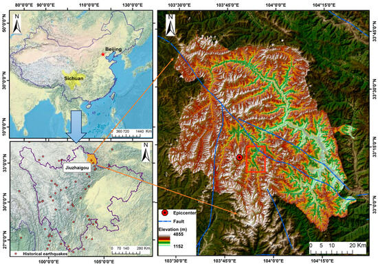
Figure 1.
Location of the study area. The red line delineates the boundary of the study area.
Zhangzha Town, located within the Jiuzhaigou National Scenic Area (a UNESCO World Heritage Site and Biosphere Reserve), is both a popular tourist destination and an economic hub in Sichuan Province. However, the region is prone to natural disasters such as earthquakes, landslides, and rockfalls, posing risks to residents and visitors.
At 9:19:46 p.m. (UTC + 08:00) on 8 August 2017, a seismic event of Ms 7.0 struck Jiuzhaigou County, with an epicenter located at 33°11′34.8″ N and 103°53′6″ E. According to the China Earthquake Networks Center, the epicenter was situated approximately 285 km from Chengdu, the provincial capital of Sichuan. The average elevation of the epicentral area is about 3827 m. This earthquake was characterized as a strike-slip event [36]. The Jiuzhaigou earthquake resulted from the horizontal displacement of faults near the Minjiang, Tazang, and Huya fault zones, which play crucial roles in controlling regional seismic activity. The presence of these fault systems, together with the lithological diversity of the region, contributes to its high susceptibility to landslides during seismic events. The tectonic background and geological setting of the Jiuzhaigou region are shown in Figure 2, with fault data provided by the Seismic Active Fault Survey Data Center (https://www.activefault-datacenter.cn, accessed on 30 October 2025).
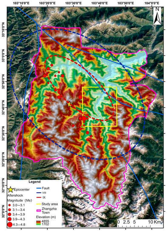
Figure 2.
Location of the Jiuzhaigou earthquake and geological setting of the study area.
Zhangzha Town, located in a rugged mountainous region, is characterized by steep slopes, deep valleys, and sharp ridges, shaped by glacial, fluvial, and tectonic processes. The area’s rock strata are mainly composed of carbonate rocks like dolomite and tufa, along with sandstone and shale, which enhance its scenic beauty but also increase its vulnerability to landslides and other geomorphological hazards. The combination of steep terrain and frequent seismic activity makes the region particularly prone to co-seismic landslides, even from minor earthquakes.
The 2017 Ms 7.0 earthquake severely impacted the national park, leading to a closure lasting nearly three years. It struck during peak tourist season, affecting 40,000 visitors and causing 25 fatalities, 525 injuries, and significant infrastructure damage, including the collapse of 76 houses. Given the region’s history of major seismic events, Zhangzha Town is a critical site for studying the effects of earthquakes, particularly co-seismic landslides, and their impact on disaster management. The socioeconomic and environmental significance of Jiuzhaigou further underscores the importance of understanding and mitigating these risks.
2.2. Data
In this study, Sentinel-2A satellite remote sensing images were selected as the data source from the official website of the ESA (European Space Agency, https://browser.dataspace.copernicus.eu, accessed on 30 October 2025). The Sentinel-2A satellite is equipped with high-resolution multispectral imaging capabilities and provides varying spatial resolutions across different bands, ranging from the visible and near-infrared to the short-wave infrared. The specific band parameters used in this study are shown in Table 1.

Table 1.
Sentinel 2A satellite sensor parameters.
The pre-earthquake and post-earthquake images from Sentinel-2A on 29 July 2017 and 7 September 2017 were selected. To minimize the impact of cloud contamination on landslide detection, a rectangular subset with minimal cloud cover within Zhangzha Township was extracted for analysis. The study area extends from 103°51′26″ E to 103°57′4″ E and from 33°8′14″ N to 33°14′55″ N, covering approximately 109.24 km2. The pre- and post-earthquake images are shown in Figure 3.
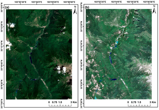
Figure 3.
Remote sensing images of Sentinel-2A: (a) pre-earthquake, (b) post-earthquake.
A total of 193 co-seismic landslides covering approximately 6.3665 km2 were identified in the study area. The co-seismic landslide inventory used in this study was established through manual visual interpretation of multi-temporal Sentinel-2A imagery. Manual interpretation was adopted because existing automatic inventories often contain substantial noise and omission errors, particularly in areas affected by dense vegetation, cloud contamination, or shadowing, and therefore cannot reliably provide ground-truth data for model training and evaluation. The interpretation process followed widely accepted geomorphological principles, identifying landslides based on abrupt spectral changes between pre- and post-earthquake images, exposure of bare soil or rock, disturbance or loss of vegetation, and the presence of morphological features such as scarps, tension cracks, and accumulation zones that are characteristic of mass movement processes. The imagery was interpreted independently by two trained analysts, and any discrepancies were resolved through cross-verification to ensure consistency and reliability. The resulting manually interpreted inventory serves as the labeled dataset for the deep learning classification methods and provides essential reference data for evaluating the performance of all automatic co-seismic landslide detection techniques used in this study. The interpretation results are shown in Figure 4.
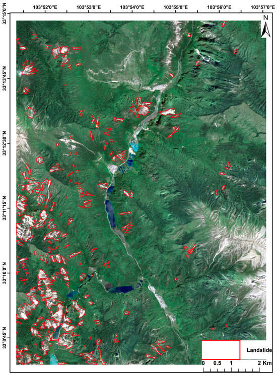
Figure 4.
The results of visually interpreting co-seismic landslides in the study area.
3. Methods
Commonly used methods for detecting co-seismic landslides from remote sensing images include visual interpretation, change detection, supervised classification, object-oriented analysis, and DL. The overall workflow of this study is shown in Figure 5. The workflow is summarized as follows:
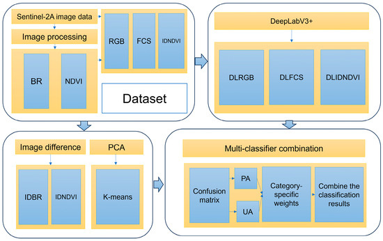
Figure 5.
The flowchart of this study.
- Employ manual visual interpretation to identify co-seismic landslides in the study area.
- Create a database of co-seismic landslides for the validation of an automated landslide detection method.
- Utilize ID with BR and NDVI images, PK with BR images, along with DL using RGB, FCS, and IDNDVI images for co-seismic landslide detection.
- Evaluate the classification results by using a confusion matrix, with the established database serving as the validation dataset.
- Combine the classification results of each classifier by the WPU method, based on category-specific weights of accuracy evaluation results.
- Conduct a comparative analysis between the combination results of multi-classifier classification and six single classifiers.
3.1. Image Differencing Classification
The ID method involves subtracting pixel gray values between corresponding pixels in multi-temporal images to detect changes [37,38,39,40]. This method is commonly used for co-seismic landslide detection, highlighting changes in spectral characteristics before and after an earthquake. In this study, the ID method is applied to BR and NDVI images from remote sensing data before and after the earthquake to detect co-seismic landslides.
BR operation enhances image features by calculating the ratio of pixel values between spectral bands [41]. To effectively detect landslides, spectral bands with significant contrast in reflectance are selected. Landslides typically show higher reflectance in the red band compared to vegetation, making the red–green band ratio suitable for distinguishing landslides from other land features. The pre-earthquake and post-earthquake band ratio images are shown in Figure 6.
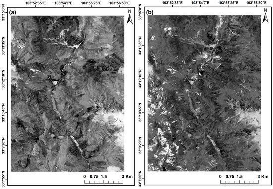
Figure 6.
Band ratio image in the study area: (a) pre-earthquake, (b) post-earthquake.
The NDVI entails dividing the difference between the reflectance values of the near-infrared and red bands by their sum [42]. The formula for this calculation is as follows:
where represents the surface reflectance in the near-infrared band, while represents the surface reflectance in the red band. NDVI is a key indicator of vegetation coverage and is positive when vegetation is present. By comparing the pre- and post-earthquake NDVI values, changes in vegetation coverage can be analyzed, reflecting the damage caused by co-seismic landslides in the study area [43]. The pre-earthquake and post-earthquake NDVI images are shown in Figure 7.
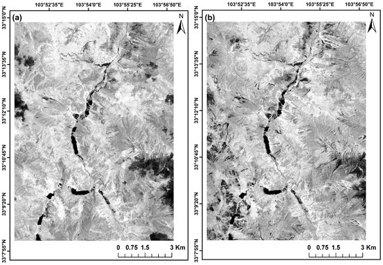
Figure 7.
NDVI image in the study area: (a) pre-earthquake, (b) post-earthquake.
3.2. PCA-Based K-Means Classification Method
PCA is a statistical technique that reduces the dimensionality of a high-dimensional dataset by identifying principal components, which are linear combinations of the original variables [44]. These components capture the maximum variance in the data, simplifying the dataset while retaining essential information.
K-means is an unsupervised clustering algorithm that groups data points into a predefined number of clusters based on their similarity. In this study, the principal components obtained from PCA were used as input for the K-means algorithm to classify the data into distinct clusters representing different land cover types, such as landslides, vegetation, water bodies, and built-up areas. The optimal number of clusters was determined through iterative experimentation, ensuring accurate classification.
PCA was applied to the pre- and post-earthquake BR images to eliminate noise and redundant information, enhancing the efficiency of the classification process. The PCA images derived from the BR images are shown in Figure 8. The PK classification method, which combines PCA and K-means clustering, improves the detection and classification of co-seismic landslides in remote sensing imagery. This method reduces dataset dimensionality while preserving key information, thereby increasing the accuracy and efficiency of landslide detection [45].
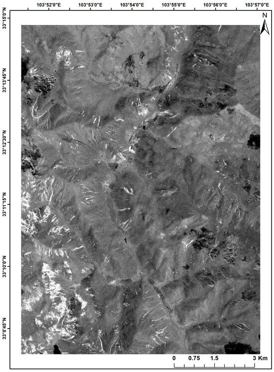
Figure 8.
PCA images derived from BR images.
3.3. Deep Learning Classification Method
As a cutting-edge field in machine learning, DL combines low-level features through multi-layer artificial neural networks to form abstract high-level representations that support data interpretation [46,47,48,49]. DL can further generate more expressive high-level features from remote sensing imagery by integrating multi-scale and multi-level information [50,51]. It constructs a nonlinear hierarchical learning structure that enables intelligent feature learning and classification.
In this study, we utilized DeepLabv3+ as the DL model for co-seismic landslide detection using RGB, FCS, and IDNDVI images. DeepLabv3+ is a semantic segmentation model that extends DeepLabv3 by incorporating an encoder–decoder structure and improving boundary delineation to achieve more refined segmentation results [52]. This approach is well suited for high-resolution satellite imagery, as it effectively captures complex spatial patterns and provides precise segmentation of landslide areas. The structure of the DeepLabV3+ model is shown in Figure 9.
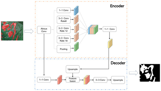
Figure 9.
Structure of the DeepLabV3+ model.
3.4. Evaluation Metrics for the Accuracy of the Confusion Matrix
In remote sensing image classification, errors arise due to inadequate preprocessing, mixed pixels, and spectral confusion. Classification accuracy reflects the degree of agreement between the obtained results and the “reality.” A confusion matrix compares predicted classifications with actual values, whereas for binary classification (e.g., co-seismic landslides), it is a 2 × 2 matrix, as shown in Table 2.
Table 2.
Confusion matrix indicator.
TP represents true positives, which are correctly classified positive samples; FN represents false negatives, which are incorrectly classified positive samples; FP represents false positives, which are incorrectly classified negative samples; and TN represents true negatives, which are correctly classified negative samples.
The overall accuracy (OA), producer’s accuracy (PA), user’s accuracy (UA), Kappa coefficient (Kappa), and F1-score can be computed from the confusion matrix to quantitatively evaluate the classification performance.
The OA is the ratio of correctly classified instances to the total samples. In the context of co-seismic landslide detection, the overall accuracy denotes the ratio of correctly detected landslide pixels to the total number of pixels. The calculation formula is as follows:
The Kappa coefficient is a proportion that measures the reduction in errors between classification and random classification. The Kappa coefficient measures the agreement between classification and random chance. The calculation formula is as follows:
The PA, also known as mapping accuracy, is the conditional probability that the classification result of a specific location on a thematic map is consistent with the corresponding random sample in the reference data. In the context of co-seismic landslide detection, the PA refers to the ratio of the number of pixels correctly classified as landslides to the total number of actual landslide pixels. It can be calculated using the following formula:
The UA refers to the conditional probability of randomly selecting a sample from the classified results that has the same type as the ground truth. In the context of co-seismic landslide detection, the UA specifically represents the ratio of the total number of correctly classified pixels belonging to the landslide class to the total number of pixels classified as belonging to the landslide class. The calculation formula is as follows:
The F1-score is a metric used in statistics to measure the accuracy of a binary classification model. It takes into account both the precision and recall of the classification model. A higher F1-score indicates better predictions. The formula for calculating the F1-score is as follows:
Among the accuracy indexes of a confusion matrix, the PA reflects the number of missed scores in the classification result. The higher the number of missed scores, the lower the PA, and vice versa. While UA can indicate the presence of misclassification in the classification result, it is important to note that higher misclassification rates correspond to lower UA, while lower misclassification rates correspond to higher UA. Achieving high values for both PA and UA in a single classifier is challenging.
3.5. Multi-Classifier Combination with Weighted Voting
The accuracy of remote sensing image classification depends not only on the quality of the data but also on the classification method. Different classifiers applied to the same image can yield varying results, and maintaining consistent accuracy across environments is challenging. Each classifier tends to perform better on certain feature classes, and achieving both high PA and UA from a single classifier is often difficult. Previous studies on co-seismic landslide detection have shown that no single classifier consistently outperforms others across all accuracy metrics. Specifically, it is challenging to achieve a combination of high PA and high UA when evaluating the accuracy of classification results from a single classifier.
In this study, the WPU method combines IDBR, IDNDVI, PKBR, DLRGB, DLFCS, and DLIDNDVI with every single classifier to fuse the classification results. The flowchart of the WPU method is depicted in Figure 10. The specific flow of the experiment is as follows:
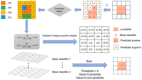
Figure 10.
The flowchart of the WPU method.
- (1)
- Binarize the classification results of the six base classifiers to obtain the binarized image of co-seismic landslide for each base classifier.
- (2)
- Assign category-specific weights to classifiers based on PA and UA from confusion matrix evaluation.
- (3)
- Apply weights to the binarized images of co-seismic landslides obtained from each classifier to generate weighted images.
- (4)
- Fuse the weighted images and apply a threshold for final classification.
4. Results
4.1. Accuracy of Single Classifier Results
The classification results of IDBR, IDNDVI, and PKBR are illustrated in Figure 11.
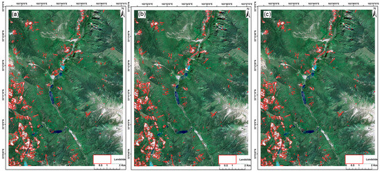
Figure 11.
(a) IDBR, (b) IDNDVI, and (c) PKBR.
The image differencing method is simple to operate and time-efficient. The detection performance of IDBR and IDNDVI for co-seismic landslides is average. However, due to various interfering factors—such as sensor characteristics, imaging time, weather conditions, and human disturbances—the image differencing method is unable to accurately detect landslides when facing changes in the study area that are not solely caused by landslides, such as vegetation clearance, shadow occlusion, and cloud cover variation. Therefore, the detection performance of the image differencing method is relatively poor in areas with complex land cover types. Moreover, the method relies heavily on threshold values, leading to significant missed detections when the threshold is set too high and a large number of false positives when the threshold is set too low.
The PKBR method is effective for dimensionality reduction and clustering in co-seismic landslide detection. However, the performance is challenged by the variability and complexity of the terrain, as the clustering may misclassify non-landslide areas with similar spectral properties. The effectiveness of the method heavily depends on the optimal selection of the number of clusters (K), and it may struggle in areas where landslide and non-landslide regions have minimal spectral differences. This makes PKBR less reliable in regions with diverse and intricate land cover types.
The classification results of DLRGB, DLFCS, and DLIDNDVI are shown in Figure 12.
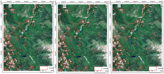
Figure 12.
(a) DLRGB, (b) DLFCS, and (c) DLIDNDVI.
In general, all three sets of models demonstrate proficient detection of co-seismic landslides, with the landslide detection being more comprehensive. The DL model exhibits fewer misclassifications within the internal region of the landslide while being more prone to misjudgments at the boundary region of the landslide.
Table 3 reveals that the overall classification accuracy of the six experimental groups is consistently high, exceeding 0.95, indicating a high level of agreement with minimal variation. Considering the significant difference in area between landslide and non-landslide regions within the study area, the significance of PA, UA, and Kappa is greater than that of OA. PA for IDBR, IDNDVI, and PKBR is considerably lower than UA, suggesting that these two methods are more prone to false negatives in landslide detection. The overall classification accuracy of the three DL experiments shows minimal discrepancy. The Kappa coefficient for DLRGB slightly surpasses the other two experimental groups, implying that DLRGB demonstrates higher consistency in classification accuracy across different categories, making it more applicable for co-seismic landslide detection. Despite differences in PA and UA among the three experimental groups, they possess significant practical value in the detection of co-seismic landslides.
Table 3.
The accuracy results of the single classifier for classification.
4.2. Accuracy of WPU
Based on the experimental results of the automatic detection method for co-seismic landslides shown in Table 4, the WPU method integrates the classification results of IDBR, IDNDVI, PKBR, DLRGB, DLFCS, and DLIDNDVI.
Table 4.
PA and UA of the six single classifiers.
The combined results of multiple classifiers are shown in Figure 13. As illustrated, the WPU fusion method achieves high accuracy in detecting co-seismic landslides and produces more complete and spatially continuous landslide delineations. Compared with the outputs of individual classifiers, the WPU results exhibit fewer omissions and fragmented regions, demonstrating the effectiveness of multi-classifier fusion in enhancing the overall detection quality.
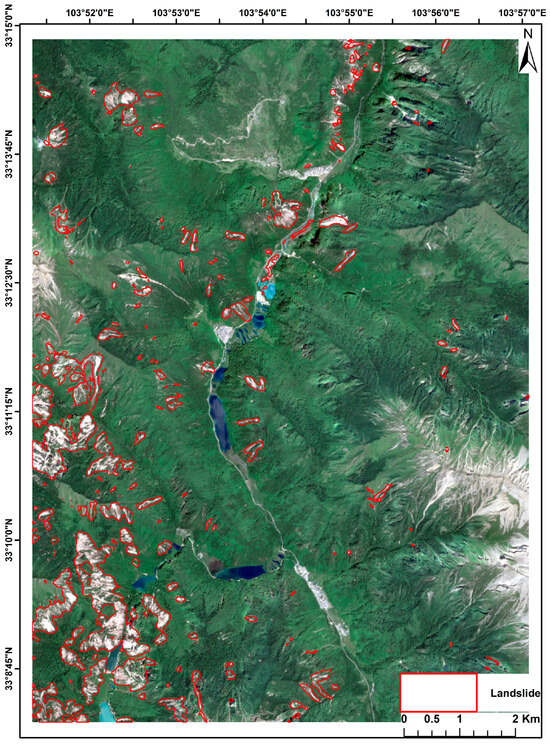
Figure 13.
The classification results of WPU.
Compared with the classification results obtained using the image differencing–based methods (IDBR and IDNDVI), the multi-classifier fusion approach produces fewer omissions within landslide bodies, a higher detection rate, and fewer misclassified pixels. In contrast to the clustering-based PKBR method, the fused results exhibit improved robustness in areas with complex land cover. Furthermore, when compared with the three DL-based classifiers (DLRGB, DLFCS, and DLIDNDVI), the multi-classifier fusion approach produces more spatially coherent landslide polygons, fewer isolated small patches, and reduced misclassification errors, particularly along landslide boundaries.
The quantitative accuracy of the WPU-based multi-classifier fusion results, assessed using confusion matrix metrics, is presented in Table 5.
Table 5.
The accuracy of WPU.
The OA of WPU is 0.9755, indicating good performance in detecting co-seismic landslides. The Kappa coefficient of the classification results reaches 0.7848, demonstrating a high level of consistency with the true co-seismic landslides. The PA of WPU’s classification results is 0.8311, while the UA is 0.7672. The F1-score is 0.7979, suggesting that there are fewer misclassifications and omissions in the classification results, and the ability to classify both co-seismic landslides and non-co-seismic landslides is relatively balanced.
By combining the accuracy evaluation results from the multi-classifier combination experiments and the six sets of single-classifier experiments in the automated co-seismic landslide detection experiments, we compare the differences in classification accuracy between the multi-classifier combination method and the six base classifiers in Table 6.
Table 6.
The accuracy of all classifiers.
Figure 14 presents the representative classification results of all classifiers. The image-differencing-based methods (IDBR and IDNDVI) and the clustering-based PKBR method provide relatively clearer delineation of landslide boundaries, owing to their sensitivity to abrupt spectral changes. In contrast, the DL-based classifiers produce more complete and spatially coherent landslide detections, effectively capturing the overall morphology of landslide bodies. Although the boundary sharpness of the DL methods is slightly inferior to that of the image differencing approaches, the DL results maintain better internal consistency and exhibit fewer voids and fragmented patches within the landslide regions. These characteristics highlight the complementary strengths of traditional and deep-learning-based classifiers and underscore the necessity of multi-classifier fusion for enhancing co-seismic landslide detection performance.
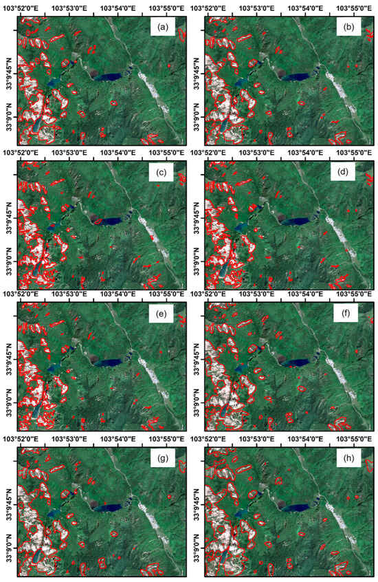
Figure 14.
(a) Visual interpretation of co-seismic landslides, (b) WPU, (c) IDBR, (d) IDNDVI, (e) PKBR, (f) DLRGB, (g) DLFCS, and (h) DLIDNDVI.
5. Discussion
5.1. Performance of the WPU Method
This study proposed the weighted PA–UA method for detecting co-seismic landslides in the Jiuzhaigou Ms 7.0 earthquake-affected area. By integrating class-specific voting weights derived from producer’s accuracy and user’s accuracy, the WPU method fuses the outputs of six classifiers, addressing the limitations of relying on a single classifier for high-resolution remote sensing image analysis.
Experimental results showed that WPU achieved an overall accuracy of 0.9755, a Kappa coefficient of 0.7848, and an F1-score of 0.7979, significantly outperforming individual classifiers. The multi-classifier ensemble improved detection accuracy and stability by compensating for the weaknesses of each base classifier. Furthermore, the method enhanced the consistency and completeness of landslide delineation in complex environments. These results demonstrate the effectiveness of the WPU method for reliable co-seismic landslide detection.
5.2. Advantages of the WPU Method
The WPU method offers several advantages, including flexibility in classifier selection, improved detection accuracy, enhanced robustness, and adaptability to different scenarios. Unlike traditional voting schemes that treat all classifiers equally, WPU assigns class-specific weights derived from the producer’s accuracy and user’s accuracy, allowing classifiers with stronger performance in specific categories to contribute more effectively to the final decision. This weighting strategy mitigates the impact of individual classifier weaknesses and produces more reliable classification results, particularly in complex environments. Moreover, because WPU does not impose restrictions on the number or type of classifiers included, it accommodates diverse data sources and model characteristics, enabling broad applicability across remote-sensing-based landslide detection tasks.
The improved accuracy and robustness achieved by WPU have meaningful implications for earthquake-induced landslide assessment. More complete and consistent landslide delineation supports timely post-disaster evaluation, enhances situational awareness, and facilitates more informed decision-making for emergency response efforts. By providing a stable and transferable multi-classifier fusion framework, the WPU method addresses key challenges associated with heterogeneous terrain conditions and variable image characteristics, offering a practical and effective tool for co-seismic landslide detection in operational applications.
5.3. Challenges and Future Research Directions
Despite the promising results of this study, several limitations remain. First, the spatial extent of the study area is relatively small, and the performance of the WPU method in larger and more heterogeneous environments has not yet been systematically evaluated. A confined test region may restrict the assessment of the model’s generalization capability, particularly in landscapes with diverse geomorphological, geological, and climatic conditions. Future work should therefore validate the WPU framework across broader earthquake-affected areas to more rigorously examine its robustness and adaptability. Although the landslide inventory used in this study was manually interpreted for the Jiuzhaigou earthquake, the interpretation criteria and workflow are not event-specific, suggesting that the approach can be extended to other earthquake-induced landslide scenarios. Expanding the interpretation process to additional regions will further support the evaluation of the proposed method’s generalization potential.
Among the six individual classifiers employed in this research, IDBR and IDNDVI exhibited comparatively limited performance, indicating that image differencing is less suitable for practical landslide detection under complex environmental conditions. These methods are highly sensitive to variations in satellite acquisition, atmospheric conditions, seasonal changes, and human disturbances, which may lead to missed detections and false positives. Although thresholding and noise suppression procedures can mitigate some of these effects, they may also introduce additional classification errors. For instance, in both the IDBR and IDNDVI results, some water bodies were incorrectly detected as landslides due to spectral similarity under specific imaging conditions. The pronounced accuracy gap between the ID-based and DL-based classifiers also presents challenges for harmonizing heterogeneous outputs within an ensemble framework.
Future research should explore more diverse base classifiers, refine fusion strategies, and further develop multi-classifier ensemble techniques. Incorporating additional classifiers—such as SVM, random forest, and XGBoost—may increase ensemble diversity and enhance detection robustness. Moreover, the present study frames co-seismic landslide detection as a binary classification task; expanding the classification scheme to distinguish multiple land-cover types or different landslide categories may improve detection precision in complex terrain. Finally, although weighted voting provides a simple and effective mechanism for classifier fusion, more advanced ensemble learning strategies could be investigated to further improve model performance, cross-sensor consistency, and practical applicability.
6. Conclusions
In this study, six classifiers derived from Sentinel-2A imagery—IDBR, IDNDVI, PKBR, DLRGB, DLFCS, and DLIDNDVI—were used to detect co-seismic landslides triggered by the 2017 Ms 7.0 Jiuzhaigou earthquake. To integrate the complementary strengths of these heterogeneous classifiers, we introduced the WPU ensemble method, which assigns class-specific weights based on the producer’s accuracy and user’s accuracy. The proposed ensemble significantly outperformed any single classifier, achieving an overall accuracy of 0.9755, a Kappa coefficient of 0.7848, and an F1-score of 0.7979, while yielding more complete and consistent landslide delineation in complex mountainous terrain.
While the results demonstrate the effectiveness of WPU for co-seismic landslide detection, further validation is required across larger and more diverse earthquake-affected areas to better assess its generalization capability. Future research should explore additional classifiers and more advanced ensemble strategies, as well as potential extensions to multi-class land-cover mapping or more detailed landslide categorization. Overall, the WPU framework provides a practical and adaptable approach for enhancing landslide detection and has strong potential to support post-earthquake assessment and hazard analysis.
Author Contributions
Conceptualization, Y.L.; methodology, Y.L. and Z.Z.; software, Y.L.; formal analysis, Y.L. and Z.Z.; investigation, Y.L. and X.W.; data curation, Y.L. and X.W.; validation, X.W.; visualization, Y.L. and X.W.; writing—original draft preparation, X.W.; writing—review and editing, X.W., J.Z., and Z.Z.; resources, J.Z.; supervision, J.Z.; project administration, J.Z.; funding acquisition, J.Z. All authors have read and agreed to the published version of the manuscript.
Funding
This study was supported in part by the Lhasa National Geophysical Observation and Research Station, grant number NORSLS22-05; the National Natural Science Foundation of China, grant number 42201077; the Hebei Provincial Key Research and Development Program Project “Real-time Disaster Monitoring and Assessment by UAVs and Public Network Emergency Communication Technology”, grant number 23375402D; the China Postdoctoral Science Foundation, grant number 2023M732105; and the Youth Innovation Team Project of Higher School in Shandong Province, China, grant number 2024KJH087.
Data Availability Statement
The data presented in this study are available on request from the corresponding author. (The datasets generated and analyzed during the current study are not publicly available due to laboratory-specific requirements and restrictions on data sharing).
Acknowledgments
We would like to thank the editors and the anonymous reviewers for their insightful comments and suggestions. We also acknowledge the data support from “China Earthquake Disaster Prevention Center, Seismic Active Fault Survey Data Center (https://www.activefault-datacenter.cn, accessed on 30 October 2025).
Conflicts of Interest
The authors declare no conflicts of interest.
References
- Kshetrimayum, A.; H, R.; Goyal, A. Exploring different approaches for landslide susceptibility zonation mapping in Manipur: A comparative study of AHP, FR, machine learning, and deep learning models. J. Spat. Sci. 2024, 1–30. [Google Scholar] [CrossRef]
- Liu, M.; Liu, J.; Xu, S.; Chen, C.; Bao, S.; Wang, Z.; Du, J. 3DCNN landslide susceptibility considering spatial-factor features. Front. Environ. Sci. 2023, 11, 1177891. [Google Scholar] [CrossRef]
- Yin, Y.; Wang, F.; Sun, P. Landslide hazards triggered by the 2008 Wenchuan earthquake, Sichuan, China. Landslides 2009, 6, 139–152. [Google Scholar] [CrossRef]
- Keefer, D.K.; Larsen, M.C. Assessing landslide hazards. Science 2007, 316, 1136–1138. [Google Scholar] [CrossRef] [PubMed]
- Keefer, D.K. Investigating landslides caused by earthquakes—A historical review. Surv. Geophys. 2002, 23, 473–510. [Google Scholar] [CrossRef]
- Martino, S.; Bozzano, F.; Caporossi, P.; D’Angiò, D.; Della Seta, M.; Esposito, C.; Fantini, A.; Fiorucci, M.; Giannini, L.M.; Iannucci, R.; et al. Impact of landslides on transportation routes during the 2016–2017 Central Italy seismic sequence. Landslides 2019, 16, 1221–1241. [Google Scholar] [CrossRef]
- Xia, W.; Chen, J.; Liu, J.; Ma, C.; Liu, W. Landslide Extraction from High-Resolution Remote Sensing Imagery Using Fully Convolutional Spectral–Topographic Fusion Network. Remote Sens. 2021, 13, 5116. [Google Scholar] [CrossRef]
- Casagli, N.; Intrieri, E.; Tofani, V.; Gigli, G.; Raspini, F. Landslide detection, monitoring and prediction with remote-sensing techniques. Nat. Rev. Earth Environ. 2023, 4, 51–64. [Google Scholar] [CrossRef]
- Ghorbanzadeh, O.; Shahabi, H.; Crivellari, A.; Homayouni, S.; Blaschke, T.; Ghamisi, P. Landslide detection using deep learning and object-based image analysis. Landslides 2022, 19, 929–939. [Google Scholar] [CrossRef]
- Yang, X.; Chen, L. Using multi-temporal remote sensor imagery to detect earthquake-triggered landslides. Int. J. Appl. Earth Obs. Geoinf. 2010, 12, 487–495. [Google Scholar] [CrossRef]
- Qu, F.; Qiu, H.; Sun, H.; Tang, M. Post-failure landslide change detection and analysis using optical satellite Sentinel-2 images. Landslides 2021, 18, 447–455. [Google Scholar] [CrossRef]
- Tehrani, F.S.; Calvello, M.; Liu, Z.; Zhang, L.; Lacasse, S. Machine learning and landslide studies: Recent advances and applications. Nat. Hazards 2022, 114, 1197–1245. [Google Scholar] [CrossRef]
- Tehrani, F.S.; Santinelli, G.; Herrera Herrera, M. Multi-Regional landslide detection using combined unsupervised and supervised machine learning. Geomat. Nat. Hazards Risk 2021, 12, 1015–1038. [Google Scholar] [CrossRef]
- Danneels, G.; Pirard, E.; Havenith, H.B. Automatic landslide detection from remote sensing images using supervised classification methods. In Proceedings of the 2007 IEEE International Geoscience and Remote Sensing Symposium, Barcelona, Spain, 23–28 July 2007; pp. 3014–3017. [Google Scholar]
- Orland, E.; Roering, J.J.; Thomas, M.A.; Mirus, B.B. Deep Learning as a Tool to Forecast Hydrologic Response for Landslide-Prone Hillslopes. Geophys. Res. Lett. 2020, 47, e2020GL088731. [Google Scholar] [CrossRef]
- Bui, D.T.; Tsangaratos, P.; Nguyen, V.-T.; Liem, N.V.; Trinh, P.T. Comparing the prediction performance of a Deep Learning Neural Network model with conventional machine learning models in landslide susceptibility assessment. CATENA 2020, 188, 104426. [Google Scholar] [CrossRef]
- Bui, T.A.; Lee, P.J.; Lum, K.Y.; Loh, C.; Tan, K. Deep Learning for Landslide Recognition in Satellite Architecture. IEEE Access 2020, 8, 143665–143678. [Google Scholar] [CrossRef]
- Kamiyama, J.; Noro, T.; Sakagami, M.; Suzuki, Y.; Yoshikawa, K.; Hikosaka, S.; Hirata, I. Detection of landslide candidate interference fringes in DInSAR imagery using deep learning. Recall 2018, 90, 94–95. [Google Scholar]
- Lu, W.; Hu, Y.; Zhang, Z.; Cao, W. A dual-encoder U-Net for landslide detection using Sentinel-2 and DEM data. Landslides 2023, 20, 1975–1987. [Google Scholar] [CrossRef]
- Thirugnanam, H. Deep Learning in Landslide Studies: A Review. In Progress in Landslide Research and Technology, Volume 1 Issue 2, 2022; Alcántara-Ayala, I., Arbanas, Ž., Huntley, D., Konagai, K., Mikoš, M., Sassa, K., Sassa, S., Tang, H., Tiwari, B., Eds.; Springer International Publishing: Cham, Swiztland, 2023; pp. 247–255. [Google Scholar]
- Wu, Y.; Liang, W. Landslide extraction model for remote sensing images based on improved DeepLabv3+. In Proceedings of the International Conference on Image, Signal Processing, and Pattern Recognition (ISPP 2024), Guangzhou, China, 1–3 March 2024; p. 1318015. [Google Scholar]
- Shahabi, H.; Rahimzad, M.; Tavakkoli Piralilou, S.; Ghorbanzadeh, O.; Homayouni, S.; Blaschke, T.; Lim, S.; Ghamisi, P. Unsupervised Deep Learning for Landslide Detection from Multispectral Sentinel-2 Imagery. Remote Sens. 2021, 13, 4698. [Google Scholar] [CrossRef]
- Wang, Y.; Gao, H.; Liu, S.; Yang, D.; Liu, A.; Mei, G. Landslide detection based on deep learning and remote sensing imagery: A case study in Linzhi City. Nat. Hazards Res. 2025, 5, 95–108. [Google Scholar] [CrossRef]
- Li, Y. The research on landslide detection in remote sensing images based on improved DeepLabv3+ method. Sci. Rep. 2025, 15, 7957. [Google Scholar] [CrossRef]
- Lv, J.; Zhang, R.; Wu, R.; Bao, X.; Liu, G. Landslide detection based on pixel-level contrastive learning for semi-supervised semantic segmentation in wide areas. Landslides 2025, 22, 1087–1105. [Google Scholar] [CrossRef]
- Giacinto, G.; Roli, F. Ensembles of Neural Networks for Soft Classification of Remote Sensing Images. In Proceedings of the European Symposium on Intelligent Techniques, Aachen, Germany, 8–11 September 1997. [Google Scholar]
- Tahraoui, A.; Kheddam, R. LULC Change Detection Using Combined Machine and Deep Learning Classifiers. In Proceedings of the 2024 IEEE 7th International Conference on Advanced Technologies, Signal and Image Processing (ATSIP), Sousse, Tunisia, 11–13 July 2024; pp. 403–408. [Google Scholar]
- Liu, L.; Zhang, Q.; Guo, Y.; Li, Y.; Wang, B.; Chen, E.; Li, Z.; Hao, S. Mapping Coniferous Forest Distribution in a Semi-Arid Area Based on Multi-Classifier Fusion and Google Earth Engine Combining Gaofen-1 and Sentinel-1 Data: A Case Study in Northwestern Liaoning, China. Forests 2024, 15, 288. [Google Scholar] [CrossRef]
- Kumar, V.; Singh Aydav, P.S.; Minz, S. Multi-view ensemble learning using multi-objective particle swarm optimization for high dimensional data classification. J. King Saud Univ.-Comput. Inf. Sci. 2022, 34, 8523–8537. [Google Scholar] [CrossRef]
- Dong, X.; Yu, Z.; Cao, W.; Shi, Y.; Ma, Q. A survey on ensemble learning. Front. Comput. Sci. 2020, 14, 241–258. [Google Scholar] [CrossRef]
- Tasci, E.; Uluturk, C.; Ugur, A. A voting-based ensemble deep learning method focusing on image augmentation and preprocessing variations for tuberculosis detection. Neural Comput. Appl. 2021, 33, 15541–15555. [Google Scholar] [CrossRef] [PubMed]
- Zhang, Y.; Liu, J.; Shen, W. A Review of Ensemble Learning Algorithms Used in Remote Sensing Applications. Appl. Sci. 2022, 12, 8654. [Google Scholar] [CrossRef]
- Kuncheva, L.I. Combining Pattern Classifiers: Methods and Algorithms; John Wiley & Sons: Hoboken, NJ, USA, 2014. [Google Scholar]
- Freund, Y.; Schapire, R.E. Experiments with a New Boosting Algorithm. In Proceedings of the International Conference on Machine Learning, Bari, Italy, 3–6 July 1996. [Google Scholar]
- Shen, H.; Lin, Y.; Tian, Q.; Xu, K.; Jiao, J. A comparison of multiple classifier combinations using different voting-weights for remote sensing image classification. Int. J. Remote Sens. 2018, 39, 3705–3722. [Google Scholar] [CrossRef]
- Lei, H.; Wang, X.; Hou, H.; Su, L.; Yu, D.; Wang, H. The earthquake in Jiuzhaigou County of Northern Sichuan, China on August 8, 2017. Nat. Hazards 2018, 90, 1021–1030. [Google Scholar] [CrossRef]
- Celik, T. Change detection in satellite images using a genetic algorithm approach. IEEE Geosci. Remote Sens. Lett. 2010, 7, 386–390. [Google Scholar] [CrossRef]
- Bruzzone, L.; Prieto, D.F. Automatic analysis of the difference image for unsupervised change detection. IEEE Trans. Geosci. Remote Sens. 2000, 38, 1171–1182. [Google Scholar] [CrossRef]
- Lu, D.; Li, G.; Moran, E. Current situation and needs of change detection techniques. Int. J. Image Data Fusion 2014, 5, 13–38. [Google Scholar] [CrossRef]
- Khelifi, L.; Mignotte, M. Deep Learning for Change Detection in Remote Sensing Images: Comprehensive Review and Meta-Analysis. IEEE Access 2020, 8, 126385–126400. [Google Scholar] [CrossRef]
- Goetz, A.F.; Vane, G.; Solomon, J.E.; Rock, B.N. Imaging spectrometry for earth remote sensing. Science 1985, 228, 1147–1153. [Google Scholar] [CrossRef]
- Kriegler, F.J.; Malila, W.A.; Nalepka, R.F.; Richardson, W. Preprocessing Transformations and Their Effects on Multispectral Recognition. In Proceedings of the 6th International Symposium on Remote Sensing of Environment, Ann Arbor, MI, USA, 13–16 October 1969. [Google Scholar]
- Jie, D.; Xiang, Z.; Wang, X.; Zheng, P.; Avtar, R.; Chen, X.; Scaringi, G.; Luo, W.; Yunus, A.P. Post-seismic topographic shifts and delayed vegetation recovery in the epicentral area of the 2018 Mw 6.6 Hokkaido Eastern Iburi earthquake. Prog. Phys. Geogr. Earth Environ. 2024, 48, 595–614. [Google Scholar] [CrossRef]
- Khadka, D.; Zhang, J.; Sharma, A. Geographic object-based image analysis for landslide identification using machine learning on google earth engine. Environ. Earth Sci. 2025, 84, 92. [Google Scholar] [CrossRef]
- Chen, L.; Xiang, X.; Wen, H.; Xiao, J.; Song, C.; Zhou, X.; Yu, J. Improve unsupervised Learning-based landslides detection by band ratio processing of RGB optical images: A case study on rainfall-induced landslide clusters. Geomat. Nat. Hazards Risk 2024, 15, 2363406. [Google Scholar] [CrossRef]
- Zhou, J.; Liu, Y.; Nie, G.; Cheng, H.; Yang, X.; Chen, X.; Gross, L. Building Extraction and Floor Area Estimation at the Village Level in Rural China Via a Comprehensive Method Integrating UAV Photogrammetry and the Novel EDSANet. Remote Sens. 2022, 14, 5175. [Google Scholar] [CrossRef]
- Liu, Y.; Zhou, J.; Qi, W.; Li, X.; Gross, L.; Shao, Q.; Zhao, Z.; Ni, L.; Fan, X.; Li, Z. ARC-Net: An Efficient Network for Building Extraction From High-Resolution Aerial Images. IEEE Access 2020, 8, 154997–155010. [Google Scholar] [CrossRef]
- Liu, Y.; Gross, L.; Li, Z.; Li, X.; Fan, X.; Qi, W. Automatic Building Extraction on High-Resolution Remote Sensing Imagery Using Deep Convolutional Encoder-Decoder With Spatial Pyramid Pooling. IEEE Access 2019, 7, 128774–128786. [Google Scholar] [CrossRef]
- Li, Y.; Zhu, W.; Wu, J.; Zhang, R.; Xu, X.; Zhou, Y. DBSANet: A Dual-Branch Semantic Aggregation Network Integrating CNNs and Transformers for Landslide Detection in Remote Sensing Images. Remote Sens. 2025, 17, 807. [Google Scholar] [CrossRef]
- Liu, Y.; Zhang, W.; Chen, X.; Yu, M.; Sun, Y.; Meng, F.; Fan, X. Landslide Detection of High-Resolution Satellite Images using Asymmetric Dual-Channel Network. In Proceedings of the 2021 IEEE International Geoscience and Remote Sensing Symposium IGARSS, Brussels, Belgium, 11–16 July 2021; pp. 4091–4094. [Google Scholar]
- He, L.; Zhou, Y.; Liu, L.; Zhang, Y.; Ma, J. Application of the YOLOv11-seg algorithm for AI-based landslide detection and recognition. Sci. Rep. 2025, 15, 12421. [Google Scholar] [CrossRef] [PubMed]
- Chen, L.-C.; Zhu, Y.; Papandreou, G.; Schroff, F.; Adam, H. Encoder-decoder with atrous separable convolution for semantic image segmentation. In Proceedings of the European Conference on Computer Vision (ECCV), Munich, Germany, 8–14 September 2018; pp. 801–818. [Google Scholar]


Disclaimer/Publisher’s Note: The statements, opinions and data contained in all publications are solely those of the individual author(s) and contributor(s) and not of MDPI and/or the editor(s). MDPI and/or the editor(s) disclaim responsibility for any injury to people or property resulting from any ideas, methods, instructions or products referred to in the content. |
© 2026 by the authors. Licensee MDPI, Basel, Switzerland. This article is an open access article distributed under the terms and conditions of the Creative Commons Attribution (CC BY) license.