A Geotechnical–Hydrogeological Property Zonation Approach for Landslide Hazard Modelling in the eThekwini Metropolitan Region, Eastern South Africa


Abstract
1. Introduction
2. The Study Area
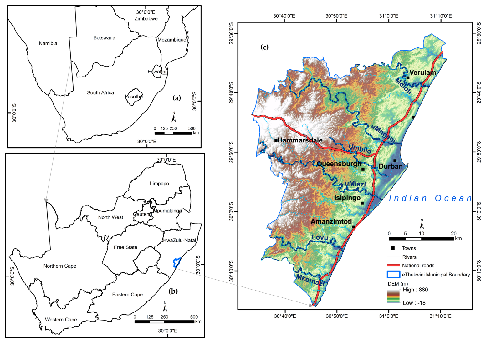
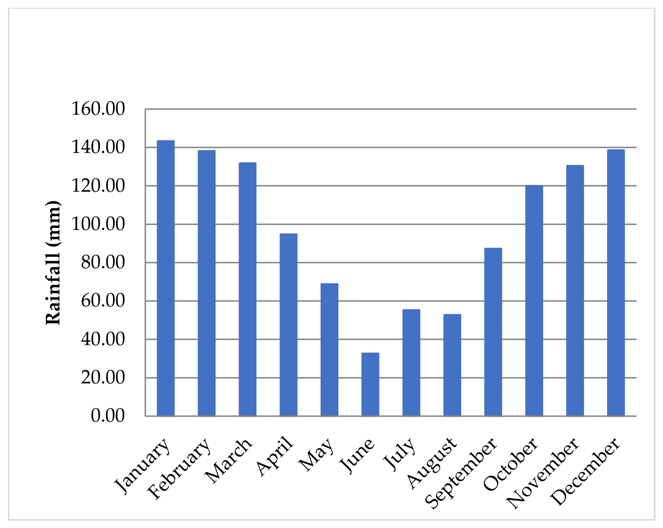
2.1. Location and Climate
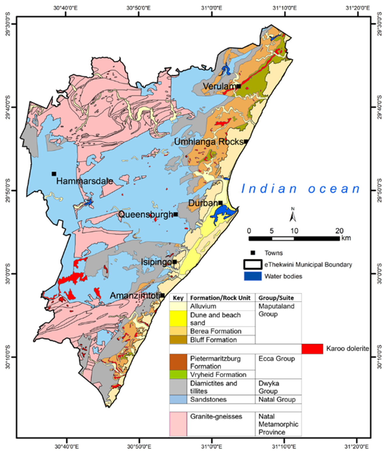
2.2. Geological and Hydrogeological Setting of the Study Area
3. Methodology
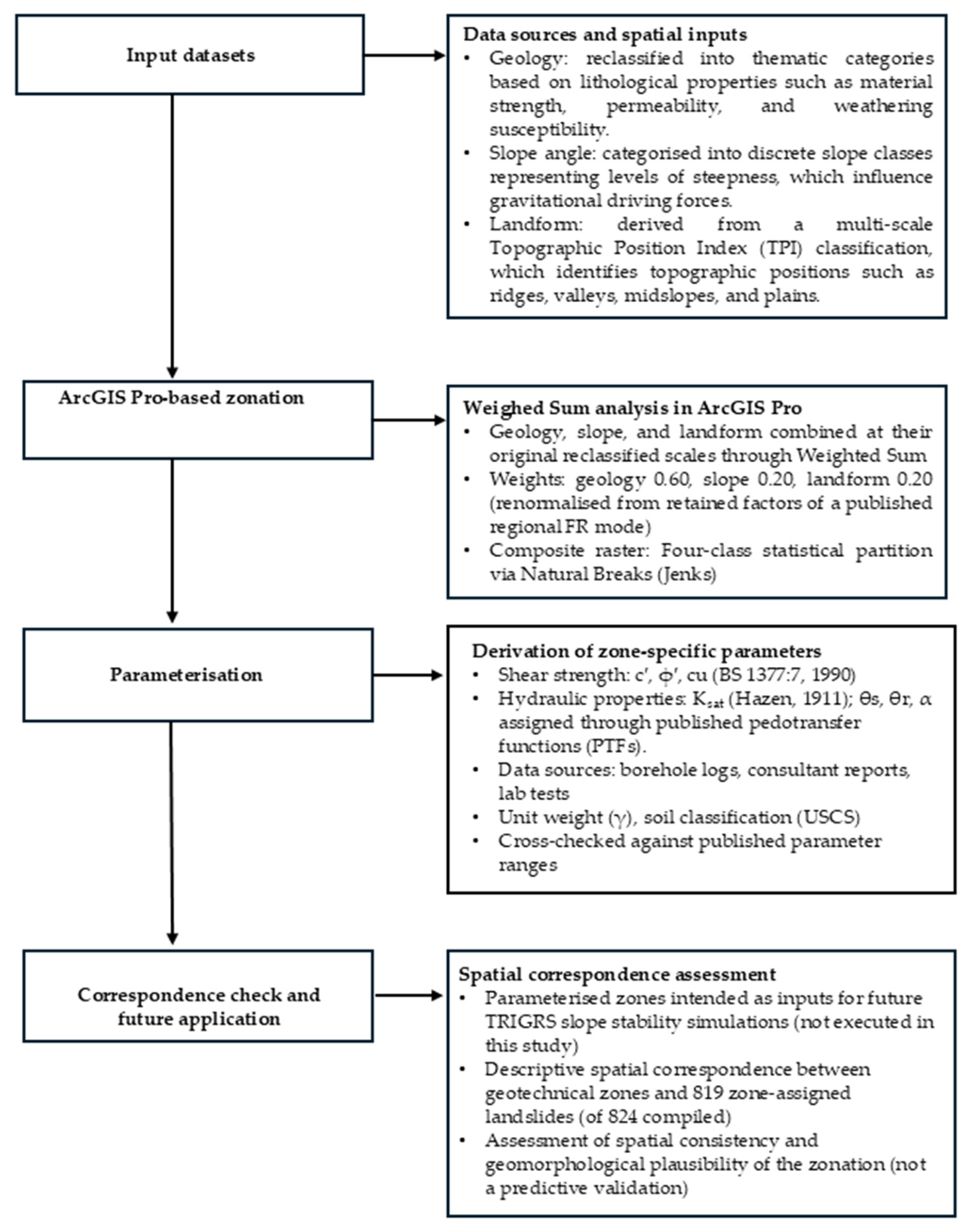
3.1. Geotechnical Zonation Approach
- ▪
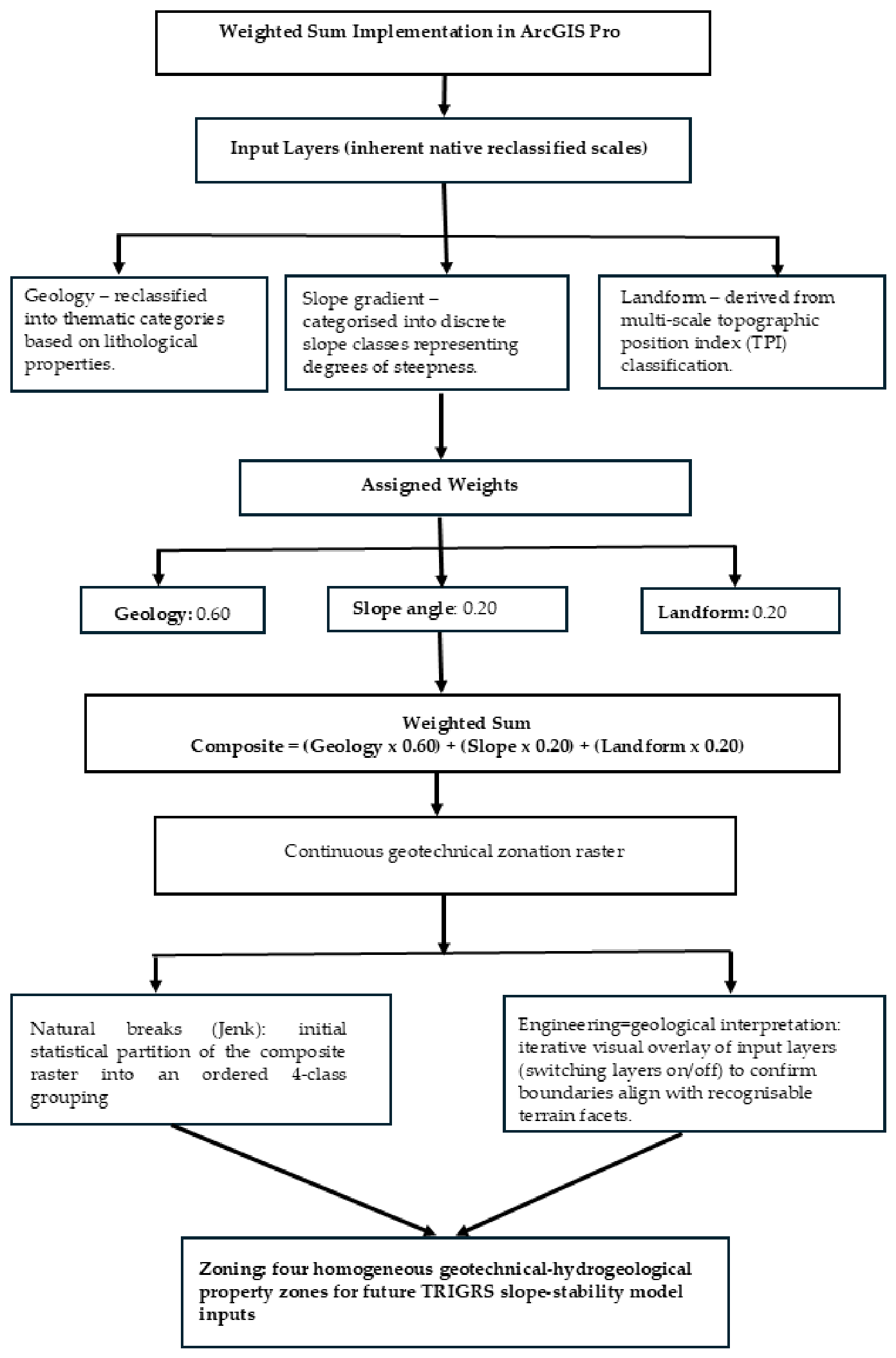
- Lithology and soil were consolidated into a single geology factor = (0.19 + 0.14)/0.55 = 0.60.
- ▪
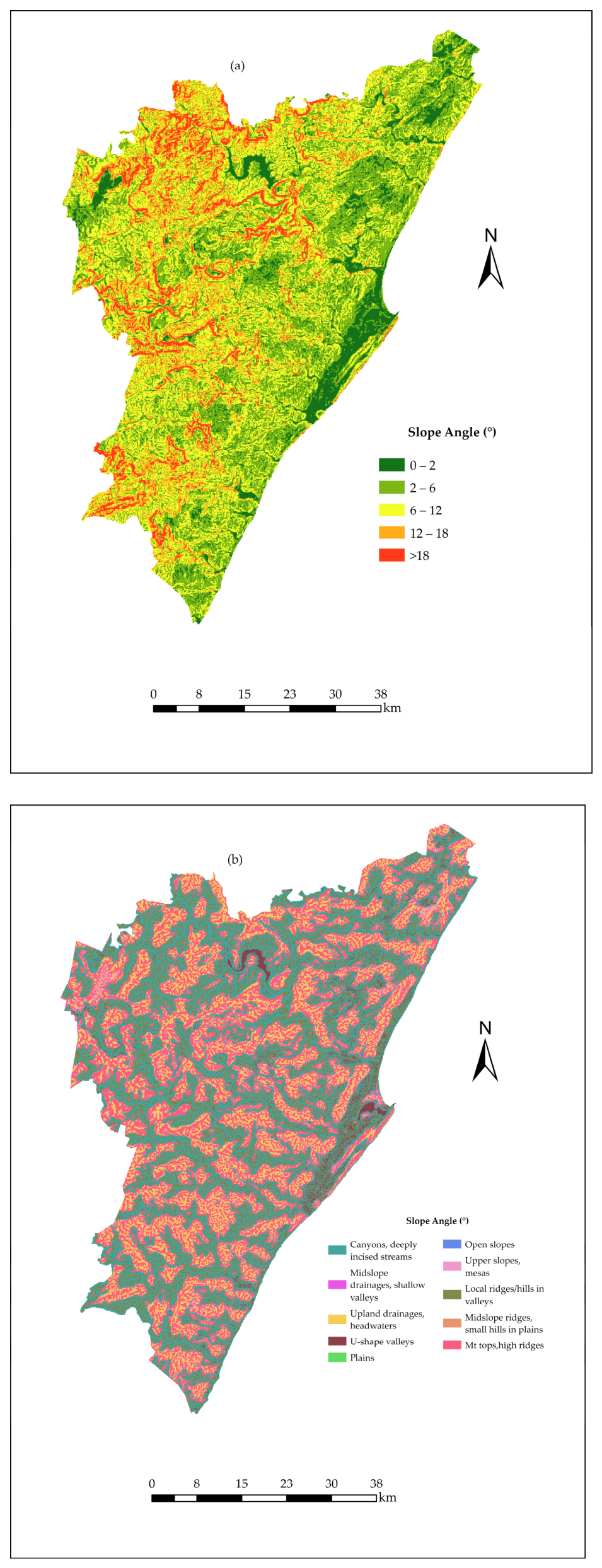
- Slope gradient = 0.11/0.55 = 0.20.
- ▪
- Profile curvature and plan curvature were consolidated into a single landform factor = (0.05 + 0.06)/0.55 = 0.20.
3.2. Determination and Derivation of Geotechnical and Hydrogeological Parameters
3.2.1. Determination of Shear Strength Parameters
3.2.2. Derivation of Hydraulic Properties


3.2.3. Derivation of Parameters for Physical-Based Infiltration Modelling
3.3. Landslide Data and Validation of Geotechnical Zones
4. Results
4.1. Geotechnical Property Zone Characterisation
4.2. Geotechnical Properties
4.3. Hydrogeological Properties
4.4. Landslide Correlation
4.5. Summary Geotechnical–Hydrogeological Zonation for Physically Based Landslide Modelling
- ▪
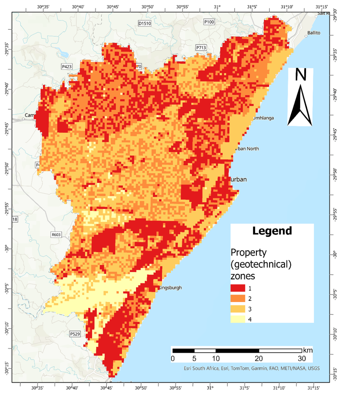
- Zone 1 (residual dolerite/diamictite–tillite) is characterised by steep, dissected ridges and upper slopes of the escarpment foothills. Representative average geotechnical parameters are: c′ = 10 kPa, ϕ′ = 30°, Ksat = 5.0 × 10⁻⁹ m/s, and θs = 0.50. These values indicate low-permeability, well-drained residual terrain.
- ▪
- Zone 2 (residual shales/alluvium) is located in mid-slopes and valley bottoms, spanning the transitional terrain between the coastal plain and escarpment foothills. Representative average geotechnical parameters values are: c′ = 5 kPa, ϕ′ = 27.5°, Ksat = 5.0 × 10⁻⁶ m/s, and θs = 0.45.
- ▪
- Zone 3 (colluvium/sandstone) occurs in lower slopes that are gentle inclines overlying the Natal Group sandstones. Representative average geotechnical parameters values are: c′ = 5 kPa, ϕ′ = 30.0°, Ksat = 1.0 × 10⁻⁶ m/s, and θs = 0.43.
- ▪
- Zone 4 (sandy granite residuals) is located on elevated plateaus and crests in the western highlands of the study area. Representative geotechnical parameter values for this zone are: c′ = 15 kPa, ϕ′ = 35.0°, Ksat = 5.0 × 10⁻⁴ m/s, and θs = 0.40.
5. Discussion
5.1. Relation of the Delineated Geotechnical Zones with Landslide Occurrences
5.2. Implications for Hazard Assessment and Land-Use Management
- ▪
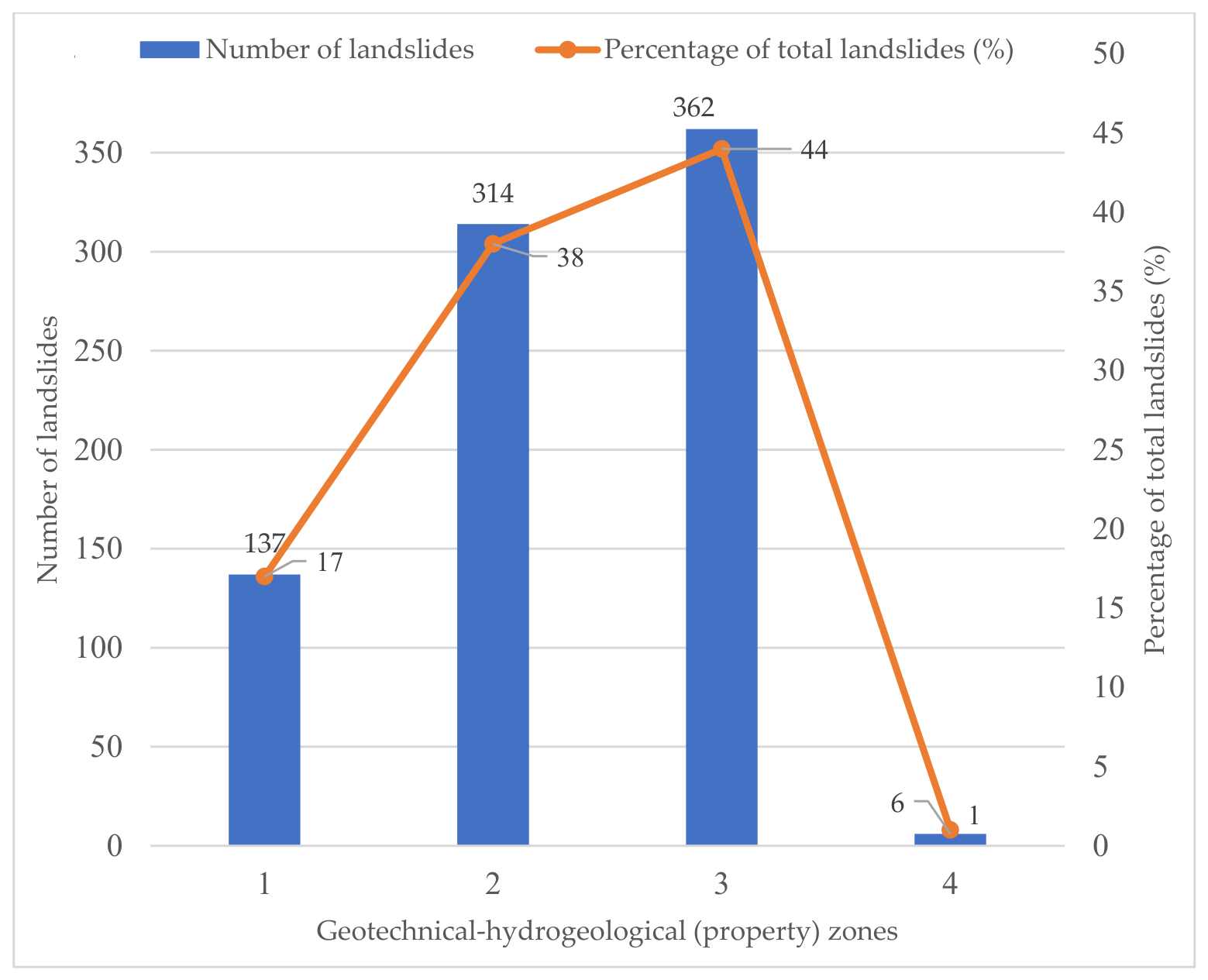
- Land-use policy: The geotechnical–hydrogeological zonation provides a scientifically defensible, qualitative and quantitative tool for municipal planners. For instance, Zones 2 and 3 of the classification of this study, which accounted for over 82% of previously documented landslides, should be immediately subjected to stricter development controls. These controls include mandatory, detailed geotechnical investigations prior to construction, restrictions on slope modifications, and the implementation of enhanced surface- and subsurface-stormwater management systems to mitigate infiltration.
- ▪
- Physically based modelling: This proposed and applied geotechnical–hydrogeological zoning significantly enhances the reliability of advanced physically based models, such as TRIGRS and Scoops3D, by supplying zone-specific, field-validated parameters (e.g., Ksat, c′, ϕ′). This reduces reliance on uniform or assumed parameter values, thereby improving the accuracy of spatially explicit rainfall-triggered landslide forecasting and establishing the quantitative foundation for an operational early-warning system.
- ▪
- Resilient infrastructure: The geotechnical–hydrogeological zonation approach facilitates the design of more resilient infrastructure, ensuring that deep drainage systems, slope stabilisation measures, and retaining structures are appropriate for the specific geotechnical and hydrogeological conditions of the terrain.
5.3. Future Research
- ▪
- Physically based model simulation: Apply the zone-specific parameter sets derived in this study within TRIGRS (or an equivalent physically based model) under representative and design-storm rainfall scenarios to generate quantitative, spatially explicit hazard maps.
- ▪
- Independent validation: Evaluate the resulting susceptibility or hazard outputs against a temporally or spatially independent landslide inventory, distinct from the FR training data and the 824-event inventory used in this study.
- ▪
- Hydraulic parameter refinement: Conduct in situ diffusivity and infiltration testing at representative locations throughout the study area to validate and refine the hydraulic and soil-water retention parameter sets (θs, θr, α) currently assigned via PTFs.
- ▪
- Sensitivity testing of zonation choices: Compare the current multi-factor (geology–slope–landform) zonation against a geology-only zonation of the kind used by Marin et al. (2020) [46], and test the sensitivity of zone boundaries and derived parameter contrasts to the chosen number of zones and to the categorical exclusion of aspect, elevation, land cover, TWI, and distance-based FR terms from the weighting.
- ▪
- Dynamic factor integration: Incorporate dynamic factors (such as land-use change, infrastructure modification, and vegetation cover) into the slope stability forecasting framework to account for evolving surface conditions and their impact on runoff and infiltration.
5.4. Limitations of the Study
6. Conclusions
Author Contributions
Funding
Institutional Review Board Statement
Informed Consent Statement
Data Availability Statement
Acknowledgments
Conflicts of Interest
Abbreviations
| AASHTO | American Association of State Highway and Transportation Officials |
| AHP | Analytic Hierarchy Process |
| ASTM | American Society for Testing and Materials |
| BS | British Standard |
| CBD | Central Business District |
| CGS | Council for Geoscience |
| FSLAM | Fast Shallow Landslide Assessment Model |
| GIS | Geographic Information System |
| GPS | Global Positioning System |
| IAEG | International Association for Engineering Geology and the Environment |
| N2/N3 | National Route 2/National Route 3 |
| NMP | Natal Metamorphic Province |
| PSD | Particle Size Distribution |
| SHALSTAB | Shallow Landslide Stability Model |
| SPT | Standard Penetration Test |
| TPI | Topographic Position Index |
| TRIGRS | Transient Rainfall Infiltration and Grid-Based Regional Slope-Stability |
| UNDRR | United Nations Office for Disaster Risk Reduction |
| USCS | Unified Soil Classification System |
| USD | United States Dollar |
| VHR | Very High Resolution |
| WoE | Weight of Evidence |
References
- Petley, D. Global Patterns of Loss of Life from Landslides. Geology 2012, 40, 927–930. [Google Scholar] [CrossRef] [Scilit]
- United Nations Office for Disaster Risk Reduction [UNDRR]. Global Assessment Report on Disaster Risk Reduction 2022: Our World at Risk: Transforming Governance for a Resilient Future; UNDRR: Geneva, Switzerland, 2022. [Google Scholar]
- Wieczorek, G.F.; Turner, A.K.; Schuster, R.L. (Eds.) Landslide Triggering Mechanisms. In Landslides: Investigation and Mitigation; Transportation Research Board Special Report; National Research Council: Washington, DC, USA, 1996; pp. 76–90. [Google Scholar]
- Duncan, J.M. Soil Strength and Slope Stability, 1st ed.; New York Academy of Sciences Series; John Wiley & Sons, Incorporated: Newark, NY, USA, 2014; ISBN 978-1-118-65165-0. [Google Scholar]
- Gariano, S.L.; Guzzetti, F. Landslides in a Changing Climate. Earth-Sci. Rev. 2016, 162, 227–252. [Google Scholar] [CrossRef] [Scilit]
- Froude, M.J.; Petley, D.N. Global Fatal Landslide Occurrence from 2004 to 2016. Nat. Hazards Earth Syst. Sci. 2018, 18, 2161–2181. [Google Scholar] [CrossRef] [Scilit]
- Mboto, S. Costs Related to KZN Floods Stand at R17 Billion. 2022. Available online: https://iol.co.za/mercury/news/2022-04-26-costs-related-to-kzn-floods-stands-at-r17-billion/ (accessed on 28 May 2025).
- Dandridge, C.; Stanley, T.A.; Kirschbaum, D.B.; Lakshmi, V. Spatial and Temporal Analysis of Global Landslide Reporting Using a Decade of the Global Landslide Catalog. Sustainability 2023, 15, 3323. [Google Scholar] [CrossRef] [Scilit]
- Reichenbach, P.; Rossi, M.; Malamud, B.D.; Mihir, M.; Guzzetti, F. A Review of Statistically-Based Landslide Susceptibility Models. Earth-Sci. Rev. 2018, 180, 60–91. [Google Scholar] [CrossRef] [Scilit]
- Toločka, A. Towards Understanding the Global Distribution of Deep-Seated Gravitational Deformations: A Study of Geological Influences and Spatial Patterns. Nat. Hazards 2025, 121, 16149–16183. [Google Scholar] [CrossRef] [Scilit]
- Broeckx, J.; Vanmaercke, M.; Duchateau, R.; Poesen, J. A Data-Based Landslide Susceptibility Map of Africa. Earth-Sci. Rev. 2018, 185, 102–121. [Google Scholar] [CrossRef] [Scilit]
- Chiliza, S.G.; Demlie, M.; Hingston, E. Predicting Shallow Rainfall-Induced Landslides in eThekwini Metropol, South Africa: Utilising the TRIGRS Model. In Proceedings of the Engineering Geology and Geotechnics: Building for the Future, Proceedings of the Conference EUROENGEO 2024; University of Zagreb Faculty of Civil Engineering: Zagreb, Croatia, 2024; pp. 177–186. [Google Scholar] [CrossRef] [Scilit]
- Montgomery, D.R.; Dietrich, W.E. A Physically Based Model for the Topographic Control on Shallow Landsliding. Water Resour. Res. 1994, 30, 1153–1171. [Google Scholar] [CrossRef] [Scilit]
- Baum, R.L.; Savage, W.Z.; Godt, J.W. TRIGRS: A Fortran Program for Transient Rainfall Infiltration and Grid-Based Regional Slope-Stability Analysis, Version 2. 2008. Available online: https://pubs.usgs.gov/of/2008/1159/ (accessed on 8 July 2024).
- Baum, R.L.; Coe, J.A.; Godt, J.W.; Harp, E.L.; Reid, M.E.; Savage, W.Z.; Schulz, W.H.; Brien, D.L.; Chleborad, A.F.; McKenna, J.P.; et al. Regional Landslide-Hazard Assessment for Seattle, Washington, USA. Landslides 2005, 2, 266–279. [Google Scholar] [CrossRef] [Scilit]
- Medina, V.; Hürlimann, M.; Guo, Z.; Lloret, A.; Vaunat, J. Fast Physically-Based Model for Rainfall-Induced Landslide Susceptibility Assessment at Regional Scale. CATENA 2021, 201, 105213. [Google Scholar] [CrossRef] [Scilit]
- Sengani, F.; Mulenga, F. Application of Limit Equilibrium Analysis and Numerical Modeling in a Case of Slope Instability. Sustainability 2020, 12, 8870. [Google Scholar] [CrossRef] [Scilit]
- Carrara, A.; Cardinali, M.; Detti, R.; Guzzetti, F.; Pasqui, V.; Reichenbach, P. GIS Techniques and Statistical Models in Evaluating Landslide Hazard. Earth Surf. Processes Landf. 1991, 16, 427–445. [Google Scholar] [CrossRef] [Scilit]
- Chacón, J.; Irigaray, C.; Fernández, T.; El Hamdouni, R. Engineering Geology Maps: Landslides and Geographical Information Systems. Bull. Eng. Geol. Environ. 2006, 65, 341–411. [Google Scholar] [CrossRef] [Scilit]
- Van Den Eeckhaut, M.; Reichenbach, P.; Guzzetti, F.; Rossi, M.; Poesen, J. Combined Landslide Inventory and Susceptibility Assessment Based on Different Mapping Units: An Example from the Flemish Ardennes, Belgium. Nat. Hazards Earth Syst. Sci. 2009, 9, 507–521. [Google Scholar] [CrossRef] [Scilit]
- Saaty, R.W. The Analytic Hierarchy Process—What It Is and How It Is Used. Math. Model. 1987, 9, 161–176. [Google Scholar] [CrossRef] [Scilit]
- Bonham-Carter, G. Geographic Information Systems for Geoscientists: Modelling with GIS. Comput. Methods Geosci. 1994, 13, 398. [Google Scholar]
- Lee, S.; Pradhan, B. Landslide Hazard Mapping at Selangor, Malaysia Using Frequency Ratio and Logistic Regression Models. Landslides 2007, 4, 33–41. [Google Scholar] [CrossRef] [Scilit]
- Ayalew, L.; Yamagishi, H. The Application of GIS-Based Logistic Regression for Landslide Susceptibility Mapping in the Kakuda-Yahiko Mountains, Central Japan. Geomorphology 2005, 65, 15–31. [Google Scholar] [CrossRef] [Scilit]
- Budimir, M.E.A.; Atkinson, P.M.; Lewis, H.G. A Systematic Review of Landslide Probability Mapping Using Logistic Regression. Landslides 2015, 12, 419–436. [Google Scholar] [CrossRef] [Scilit]
- Tien Bui, D.; Tuan, T.A.; Klempe, H.; Pradhan, B.; Revhaug, I. Spatial Prediction Models for Shallow Landslide Hazards: A Comparative Assessment of the Efficacy of Support Vector Machines, Artificial Neural Networks, Kernel Logistic Regression, and Logistic Model Tree. Landslides 2016, 13, 361–378. [Google Scholar] [CrossRef] [Scilit]
- Partridge, T.C.; Dollar, E.S.J.; Moolman, J.; Dollar, L.H. The Geomorphic Provinces of South Africa, Lesotho and Swaziland: A Physiographic Subdivision for Earth and Environmental Scientists. Trans. R. Soc. S. Afr. 2010, 65, 1–47. [Google Scholar] [CrossRef] [Scilit]
- eThekwini Municipality. Final SDF 2022–2023; eThekwini Municipality: Durban, South Africa, 2022.
- Richards, N.P. Explanation of the Engineering, Geological, and Geotechnical Conditions for the 1:50,000 Scale Map Sheet 2930 DD & 2931 CC; Council for Geoscience: Pretoria, South Africa, 2016; ISBN 978-1-920226-77-0.
- Thomas, M.A.; Van Schalkwyk, A. Geological Hazards Associated with Intense Rain and Flooding in Natal. J. Afr. Earth Sci. (Middle East) 1993, 16, 193–204. [Google Scholar] [CrossRef] [Scilit]
- McCourt, S.; Armstrong, R.A.; Grantham, G.H.; Thomas, R.J. Geology and Evolution of the Natal Belt, South Africa. J. Afr. Earth Sci. 2006, 46, 71–92. [Google Scholar] [CrossRef] [Scilit]
- Clarke, B.M.; Botha, G.A.; Kota, M.W.; Singh, R.G.; Willard, C.A.; Ngcobo, F.N. The Geology of the Durban Area: Explanation Sheets 2930DD and 2931CC; Council for Geoscience: Pretoria, South Africa, 2016; ISBN 978-1-920226-74-9.
- Bell, F.G.; Maud, R.R. Landslides Associated with the Colluvial Soils Overlying the Natal Group in the Greater Durban Region of Natal, South Africa. Environ. Geol. 2000, 39, 1029–1038. [Google Scholar] [CrossRef] [Scilit]
- Bell, F.G.; Maud, R.R. Landslides Associated with the Pietermaritzburg Formation in the Greater Durban Area, South Africa: Some Case Histories. Environ. Eng. Geosci. 1996, II, 557–573. [Google Scholar] [CrossRef] [Scilit]
- King, G.M. An Explanation of the 1:500 000 General Hydrogeological Map, Durban 2928 2002; Department of Water Affairs and Forestry (DWAF): Pretoria, South Africa, 2002.
- Ndlovu, M.S.; Demlie, M.; Butler, M. Hydrogeological Setting and Hydrogeochemical Characteristics of the Durban Metropolitan District, Eastern South Africa. S. Afr. J. Geol. 2019, 122, 299–316. [Google Scholar] [CrossRef] [Scilit]
- British Standards Institution. Methods of Test for Soils for Civil Engineering Purposes Part 7: Shear Strength Tests (Total Stress); British Standards Institution: London, UK, 1990. [Google Scholar]
- ASTM D2487-11; Standard Practice for Classification of Soils for Engineering Purposes (Unified Soil Classification System). ASTM International: West Conshohocken, PA, USA, 2011.
- American Association of State Highway and Transportation Officials. Classification of Soils and Soil-Aggregate Mixtures for Highway Construction Purposes; American Association of State Highway and Transportation Officials: Washington, DC, USA, 2012. [Google Scholar]
- Stiff, J.S. Terrain Evaluation for Urban Development. In Proceedings of the 4th Terrain Evaluation and Data Storage Symposium, Midrand, South Africa, 3–5 August 1994. [Google Scholar]
- Baynes, F.; Parry, S.; Culshaw, M.; Griffiths, J. Guidelines for the Development and Application of Engineering Geological Models on Projects. Int. Assoc. Eng. Geol. Environ. (IAEG) Comm. 2022, 25, 129. [Google Scholar]
- International Association of Engineering Geology (IAEG), Commission on Engineering Geological Maps. Engineering Geological Maps: A Guide to Their Preparation; UNESCO Press: Paris, France, 1976; Volume 15. [Google Scholar]
- Meijerink, A.M.J. Data Acquisition and Data Capture through Terrain Mapping Units. In Data Acquisition and Data Capture through Terrain Mapping Units; Meijerink, A.M.J., Ed.; ITC Publication; International Institute for Aerospace Survey and Earth Sciences (ITC): Enschede, The Netherlands, 1988; Volume 27. [Google Scholar]
- Soeters, R.; van Westen, C.J. Slope Instability Recognition, Analysis, and Zonation. In Landslides: Investigation and Mitigation; Turner, A.K., Schuster, R.L., Eds.; Transportation Research Board Special Report; National Academy Press: Washington, DC, USA, 1996; Volume 247, pp. 129–177. ISBN 0-309-06151-2. [Google Scholar]
- Singh, R.; Chiliza, G. Re-Mapping Landslide Susceptibility in the eThekwini Metropolitan Municipality, KwaZulu-Natal: Progress Report (Q4–2022/23): National Geohazards Mapping Programme; Council for Geoscience: Pretoria, South Africa, 2023.
- Marin, R.J.; Mattos, A.J.; Marín-Londoño, J. Physically-Based Definition of Rainfall Thresholds for Shallow Landslides in a Tropical Mountain Watershed of the Colombian Andes. In Proceedings of the 13th International Symposium on Landslides (ISL 2020); International Society for Soil Mechanics and Geotechnical Engineering (ISSMGE): Cartagena, Colombia, 2020. [Google Scholar]
- Jenks, G.F. The Data Model Concept in Statistical Mapping. In International Yearbook of Cartography; International Cartographic Association (ICA): Basel, Switzerland, 1976; Volume 7. [Google Scholar]
- North, M.A. A Method for Implementing a Statistically Significant Number of Data Classes in the Jenks Algorithm. In Proceedings of the 2009 Sixth International Conference on Fuzzy Systems and Knowledge Discovery; IEEE: Tianjin, China, 2009; pp. 35–38. [Google Scholar]
- Phoon, K.-K.; Kulhawy, F.H. Characterization of Geotechnical Variability. Can. Geotech. J. 1999, 36, 612–624. [Google Scholar] [CrossRef]
- Hazen, A. Some Physical Properties of Sands and Gravels, with Special Reference to Their Use in Filtration; Public Document No. 34; Massachusetts State Board of Health: Boston, MA, 1892; pp. 539–556.
- Odong, J. Evaluation of Empirical Formulae for Determination of Hydraulic Conductivity Based on Grain-Size Analysis. J. Am. Sci. 2007, 3, 54. [Google Scholar] [CrossRef]
- Hazen, A. Discussion of “Dams on Sand Foundations” by A.C. Koenig. Trans. Am. Soc. Civ. Eng. 1911, 73, 199–203. [Google Scholar]
- Das, B.M. Principles of Geotechnical Engineering, 10th ed.; Cengage: Boston, MA, USA, 2022; ISBN 978-0-357-42047-8. [Google Scholar]
- Coduto, D.P.; Yeung, M.R.; Kitch, W.A. Geotechnical Engineering: Principles and Practices, 2nd ed.; Pearson: Boston, MA, USA, 2011; ISBN 978-0-13-135425-8. [Google Scholar]
- Gardner, W.R. Some Steady-State Solutions of the Unsaturated Moisture Flow Equation with Application to Evaporation from a Water Table. Soil. Sci. 1958, 85, 228–232. [Google Scholar] [CrossRef] [Scilit]
- Carsel, R.F.; Parrish, R.S. Developing Joint Probability Distributions of Soil Water Retention Characteristics. Water Resour. Res. 1988, 24, 755–769. [Google Scholar] [CrossRef] [Scilit]
- Srivastava, R.; Yeh, T.-C.J. Analytical Solutions for One-dimensional, Transient Infiltration toward the Water Table in Homogeneous and Layered Soils. Water Resour. Res. 1991, 27, 753–762. [Google Scholar] [CrossRef] [Scilit]
- Savage, W.Z.; Godt, J.W.; Baum, R.L.; Erlich, M.; Fontoura, S.A.B.; Sayao, A.S.F. (Eds.) Modeling Time-Dependent Areal Slope Stability. In Proceedings of the 9th International Symposium on Landslides—Landslides: Evaluation and Stabilization; AA Balkema Publishers: London, UK, 2004; pp. 23–36. [Google Scholar]
- Guzzetti, F.; Carrara, A.; Cardinali, M.; Reichenbach, P. Landslide Hazard Evaluation: A Review of Current Techniques and Their Application in a Multi-Scale Study, Central Italy. Geomorphology 1999, 31, 181–216. [Google Scholar] [CrossRef] [Scilit]
- Varnes, D.J. Landslide Hazard Zonation: A Review of Principles and Practice; Natural Hazards; UNESCO: Paris, France, 1984. [Google Scholar]
- Leroueil, S.; Picarelli, L. Assessment of Slope Stability. In Proceedings of the Geotechnical Engineering State of the Art and Practice; American Society of Civil Engineers: Oakland, CA, USA, 2012; pp. 122–156. [Google Scholar]
- Iverson, R.M. Landslide Triggering by Rain Infiltration. Water Resour. Res. 2000, 36, 1897–1910. [Google Scholar] [CrossRef] [Scilit]
- Godt, J.W.; Schulz, W.H.; Baum, R.L.; Savage, W.Z. Modeling Rainfall Conditions for Shallow Landsliding in Seattle, Washington. In Landslides and Engineering Geology of the Seattle, Washington, Area; Baum, R.L., Godt, J.W., Highland, L.M., Eds.; Geological Society of America: Boulder, CO, USA, 2008; pp. 137–152. ISBN 978-0-8137-4120-8. [Google Scholar]
- Vieira, B.C.; Fernandes, N.F.; Filho, O.A. Shallow Landslide Prediction in the Serra Do Mar, São Paulo, Brazil. Nat. Hazards Earth Syst. Sci. 2010, 10, 1829–1837. [Google Scholar] [CrossRef] [Scilit]
- Dahal, R.K.; Hasegawa, S. Representative Rainfall Thresholds for Landslides in the Nepal Himalaya. Geomorphology 2008, 100, 429–443. [Google Scholar] [CrossRef] [Scilit]
- Catane, S.G.; Cabria, H.B.; Zarco, M.A.H.; Saturay, R.M.; Mirasol-Robert, A.A. The 17 February 2006 Guinsaugon Rock Slide-Debris Avalanche, Southern Leyte, Philippines: Deposit Characteristics and Failure Mechanism. Bull. Eng. Geol. Environ. 2008, 67, 305. [Google Scholar] [CrossRef] [Scilit]
- Segoni, S.; Tofani, V.; Rosi, A.; Catani, F.; Casagli, N. Combination of Rainfall Thresholds and Susceptibility Maps for Dynamic Landslide Hazard Assessment at Regional Scale. Front. Earth Sci. 2018, 6, 85. [Google Scholar] [CrossRef] [Scilit]



| Zone | Dominant Lithology/Soil | Geomorphological Setting | c′ (kPa) Mean (Range) | ϕ′ (°) Mean (Range) | γsat (kN/m3) | cu (kPa) Mean (Range) | Ksat (m/s) | θs | θr | α (m−1) | n (Lab Tests) |
|---|---|---|---|---|---|---|---|---|---|---|---|
| 1 | Residual dolerite and diamictite/tillite (CH/MH) | Steep, dissected ridges and upper slopes of the escarpment foothills | 10 (5–15) | 30 (25–35) | 19 | 45 (30–60) | 10−9–10−8 | 0.50 | 0.07 | 0.3 | 8 |
| 2 | Residual shales (CL) and alluvium/dune sands (SP/SM) | Transitional terrain spanning both the coastal plain and escarpment foothills | 5 (0–10) | 27.5 (20–35) | 19 | 25 (0–40) | 10−6–10−5 | 0.45 | 0.06 | 2.0 | 12 |
| 3 | Sandy colluvium and residual sandstone (SM) | Mid to upper slopes overlying Natal Group sandstones | 5 (0–10) | 30 (25–35) | 18.5 | 20 (15–30) | 10−8–10−5 | 0.43 | 0.05 | 1.5 | 6 |
| 4 | Residual granite gneisses and well-drained sands (SP) | Elevated plateaus and crests in the western highlands | 15 (10–20) | 35 (30–40) | 20 | 55 (40–70) | 10−4–10−3 | 0.40 | 0.04 | 4.0 | 3 |
| Parameter | n | Mean | SD | CoV (%) | Range |
|---|---|---|---|---|---|
| Plasticity Index (PI) | 12 * | 15.9 | 5.9 | 37 | 9.5–24.5 |
| Liquid Limit (LL) | 12 * | 39.3 | 8.3 | 21 | 25.8–55.5 |
| Linear Shrinkage (LS) | 18 | 4.7 | 0.0–10.6 |
| Parameter | n | Mean | SD | CoV (%) |
|---|---|---|---|---|
| Friction Angle, ϕ (°) | 10 | 30.2 | 3.2 | 10.5 |
| Cohesion, c (kPa) | 10 | 6.5 | 4.2 | 65 |
| Property Zone | Number of Landslides | Percentage of Total Landslides (%) |
|---|---|---|
| 1 | 137 | 17 |
| 2 | 314 | 38 |
| 3 | 362 | 44 |
| 4 | 6 | 1 |
Disclaimer/Publisher’s Note: The statements, opinions and data contained in all publications are solely those of the individual author(s) and contributor(s) and not of MDPI and/or the editor(s). MDPI and/or the editor(s) disclaim responsibility for any injury to people or property resulting from any ideas, methods, instructions or products referred to in the content. |
© 2026 by the authors. Licensee MDPI, Basel, Switzerland. This article is an open access article distributed under the terms and conditions of the Creative Commons Attribution (CC BY) license.
Share and Cite
Chiliza, S.G.; Hingston, E.D.C.; Demlie, M. A Geotechnical–Hydrogeological Property Zonation Approach for Landslide Hazard Modelling in the eThekwini Metropolitan Region, Eastern South Africa. GeoHazards 2026, 7, 110. https://doi.org/10.3390/geohazards7040110
Chiliza SG, Hingston EDC, Demlie M. A Geotechnical–Hydrogeological Property Zonation Approach for Landslide Hazard Modelling in the eThekwini Metropolitan Region, Eastern South Africa. GeoHazards. 2026; 7(4):110. https://doi.org/10.3390/geohazards7040110
Chicago/Turabian StyleChiliza, Sibonakaliso Goodman, Egerton D. C. Hingston, and Molla Demlie. 2026. "A Geotechnical–Hydrogeological Property Zonation Approach for Landslide Hazard Modelling in the eThekwini Metropolitan Region, Eastern South Africa" GeoHazards 7, no. 4: 110. https://doi.org/10.3390/geohazards7040110
APA StyleChiliza, S. G., Hingston, E. D. C., & Demlie, M. (2026). A Geotechnical–Hydrogeological Property Zonation Approach for Landslide Hazard Modelling in the eThekwini Metropolitan Region, Eastern South Africa. GeoHazards, 7(4), 110. https://doi.org/10.3390/geohazards7040110