Abstract
Coastal boulder deposits (CBDs) are among the most striking geomorphic signatures of extreme wave activity, recording the action of both tsunamis and severe storms. Their significance extends beyond geomorphology, providing geological archives that capture rare but high-impact events beyond the scope of instrumental or historical records. This review critically examines the origins, emplacement mechanisms, diagnostic morphology, monitoring tools, and global case studies of CBDs with the aim of clarifying the storm–tsunami debate and advancing their application in coastal hazard assessment. A systematic literature survey of 77 peer-reviewed studies published between 1991 and 2025 was conducted using Scopus and Web of Science, with inclusion criteria ensuring relevance to extreme-wave processes, geomorphic analysis, and chronological methods. Multiproxy approaches were emphasized, integrating geomatics (RTK-GPS, UAV-SfM, TLS, LiDAR), geochronology (14C, U–Th, OSL, cosmogenic nuclides, VRM), and hydrodynamic modeling. Findings show that tsunamis explain the largest and most inland megaclasts, while modern storms have proven capable of mobilizing boulders exceeding 200 t at elevations up to 30 m. Many deposits are polygenetic, shaped by successive high-energy events, complicating binary classification. CBDs emerge as multifaceted archives of extreme marine forcing, essential for refining hazard assessments in a changing climate.
1. Introduction
Coastal boulder deposits (CBDs) represent some of the most striking geomorphic signatures of extreme marine processes along rocky shorelines [1]. These megaclasts, often weighing several tons, are detached from nearshore platforms or cliff faces and transported inland, sometimes hundreds of meters landward and tens of meters above mean sea level [2]. Frequently organized as ridges, imbricated clusters, or isolated blocks, their geomorphic context often appears anomalous compared to the surrounding lithology. Because such features record events that exceed the energy of ordinary wave climates, CBDs are valuable “coarse-grained archives” of extreme coastal dynamics [3]. They complement finer-grained sedimentary records such as sand sheets, offering insights into the magnitude, recurrence, and inland penetration of high-energy waves over centennial to millennial timescales [4].
The significance of CBDs extends beyond their geomorphic interest, as they also serve as a critical source of evidence for reconstructing coastal hazards that lie outside the relatively short span of instrumental and documentary records [5,6]. Modern tsunami and storm observations cover little more than the last century, yet many rocky coasts bear the imprint of older extreme events [7,8]. Documented examples include paleotsunami-related boulder fields in the Mediterranean, Pacific, and Caribbean, as well as storm-derived ridges along the Atlantic and North Sea coasts. These records contribute to our understanding of tectonic, volcanic, and climatic hazards while challenging assumptions about the upper limits of storm-wave competence [9]. In doing so, CBD research bridges Quaternary science, geomorphology, and applied risk assessment, particularly as climate change intensifies storm regimes and amplifies sea-level rise [10,11].
The scientific understanding of CBDs has evolved considerably over the past three decades, reflecting advances in field observation, hydrodynamic modeling, and chronological techniques. Early research in the 1990s laid the foundation for differentiating between tsunami- and storm-induced boulder transports. A seminal study by Nott (1997) [12] along the Cairns coast of the Great Barrier Reef, Australia, was among the first to apply hydrodynamic principles to evaluate whether large coral boulders, some exceeding 290 t, were emplaced by cyclonic or tsunamigenic waves. The analysis demonstrated that only tsunamis could generate the required flow forces in such reef-protected environments, establishing a methodological framework for subsequent studies. Building upon this, Nott (2003) [13] further refined numerical storm-surge and wave models in northern Australia’s Gulf of Carpentaria, confirming that even the most intense tropical cyclones lacked the energy to mobilize quartzite boulders exceeding 100 t, reinforcing tsunami dominance in megaclast transport. In parallel, studies from other continental margins expanded the global scope of CBD research. For example, Goto et al. (2007) [14] analyzed over 460 boulders displaced by the 2004 Indian Ocean tsunami at Pakarang Cape, Thailand, integrating field mapping with numerical inundation modeling to link boulder orientation and distribution with oscillatory tsunami flow dynamics. Similarly, in North Africa, Mhammdi et al. (2008) [15] provided compelling evidence from the Rabat coastline (Morocco) that megaboulders up to 100 t were emplaced by the 1755 Lisbon tsunami, a finding supported by hydrodynamic calculations and post-emplacement bioerosion indicators. Together, these pioneering works marked the transition from descriptive geomorphology to process-based quantitative analysis, laying the groundwork for the modern, interdisciplinary approaches that now underpin CBD research worldwide.
For decades, large boulder displacements were attributed almost exclusively to tsunamis, whose long-period, high-magnitude flows were thought uniquely capable of mobilizing megaclasts [16,17]. However, recent field observations and experimental work have demonstrated that powerful storms, especially when combined with surge, high tides, and infragravity wave amplification, can also generate sufficient forces to transport boulders of comparable size [18,19]. Well-documented cases from the Atlantic coasts of Ireland and Portugal, where storms displaced blocks exceeding 500 tons to elevations of over 20 m, illustrate the underestimated role of storm processes [20,21]. Such findings have blurred the line between tsunami and storm signatures and fueled a longstanding debate about the diagnostic reliability of CBDs as paleotsunami indicators.
At the center of this debate lies the complexity of boulder entrainment and transport, which depends on the interplay of hydrodynamic forcing and coastal predisposition. Dislodgement often initiates along structural weaknesses such as bedding planes and joints, after which blocks may be transported by sliding, rolling, or saltation [22,23,24]. The likelihood of motion is influenced by multiple parameters, including clast geometry, density, surface roughness, slope angle, and nearshore bathymetry [22,25]. Although initiation-of-motion equations have traditionally been applied to estimate the wave heights required to mobilize boulders, their reliance on simplifying assumptions such as steady and uniform flows acting on idealized clasts significantly reduces their accuracy. Laboratory flume studies, computational simulations, and real-world monitoring have shown that transient wave groups, bore-like impacts, and turbulent three-dimensional flows can exert forces far exceeding those predicted by classical models [26,27]. As a result, interpretations based solely on motion thresholds risk overstating tsunami prevalence in the geological record.
Recent methodological advances have transformed CBD research, enabling more rigorous assessment of both past and present dynamics. High-resolution geomatics approaches, including UAV-based Structure-from-Motion, terrestrial LiDAR, and differential GPS permit precise mapping of boulder size, volume, and position, as well as the detection of incremental displacements over storm seasons [28,29,30]. Complementary dating techniques such as cosmogenic nuclide exposure, optically stimulated luminescence (OSL), and viscous remanent magnetization provide chronological resolution that was previously unattainable, allowing reconstruction of movement histories across a range of timescales [31]. Hydrodynamic modeling and physical experiments have likewise advanced, providing new insights into force regimes and transport pathways under both tsunami and storm conditions [32,33,34,35].
Despite these advances, challenges remain. Distinguishing unequivocally between storm- and tsunami-derived CBDs is still problematic, as geomorphic criteria often overlap across settings. Global inventories are also fragmented, with inconsistent data standards and varying interpretative frameworks. Addressing these limitations requires integrative approaches that combine geomorphic analysis, chronological tools, hydrodynamic modeling, and systematic monitoring within a transparent and reproducible framework. In this way, CBDs can be more effectively leveraged as archives of past extreme events and as indicators of future coastal hazard potential in an era of accelerating environmental change.
This review synthesizes current knowledge on CBD dynamics with three primary objectives (1) to evaluate the origins and forcing mechanisms behind CBDs, distinguishing the signatures of tsunami versus storm activity, (2) to discuss the mechanics of boulder dislodgement and transport in relation to coastal morphology and hydrodynamics and (3) to assess advances in measurement and assessment tools that have reshaped this field. By drawing on global case studies and methodological innovations, this review seeks to clarify the state of the art, highlight persistent uncertainties, and propose pathways for future research.
2. Literature Search and Selection Strategy
Relevant research articles and review papers were systematically identified through a comprehensive literature search using targeted keywords such as “Coastal boulder deposits”, “Extreme wave events”, “Tsunami boulders”, “Storm wave boulders”, “Boulder transport mechanisms”, “Coastal geomorphology”, “Hydrodynamic modeling”, and “Coastal hazard assessment”. To ensure that the review reflects current scientific perspectives, the search was restricted to publications from 1991 to 2025. The literature was divided into two temporal categories: (i) foundational research (1991–2014), which includes pioneering works that established the conceptual and methodological bases for CBD studies, and (ii) recent studies (2015–2025), representing current developments in monitoring technologies, modeling approaches, and hazard assessment applications. This division allows for a systematic analysis of both historical evolution and modern trends.
Literature retrieval was conducted across multiple electronic databases, including Web of Science and Scopus, which provide access to peer-reviewed and high-impact journals. To maintain quality and focus, studies were screened using predefined inclusion and exclusion criteria (Table 1).

Table 1.
Inclusion and exclusion criteria applied in the selection of literature for this review.
The inclusion criteria required that selected works be peer-reviewed, written in English, and directly address aspects of CBD dynamics, transport mechanisms, extreme forcing processes, or methodological advances in monitoring and modeling. Studies were excluded if they lacked sufficient methodological detail, fell outside the scope of coastal geomorphology and hazard assessment, or were not published in indexed scientific outlets. This structured approach ensured that the final body of literature used in the review was both credible and representative of the most recent advances in understanding CBD origins, mechanics, and implications (Figure 1).
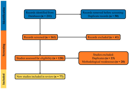
Figure 1.
PRISMA diagram of the literature identification, screening, eligibility, and inclusion process for CBD studies.
3. Sources of Extreme Forcing
The formation and reworking of CBDs are primarily associated with two categories of high-energy marine processes, including tsunamis and storms [1,15,36]. Both can generate hydrodynamic conditions capable of detaching and transporting megaclasts, yet their forcing mechanisms, temporal signatures, and geomorphic expressions differ substantially. Understanding these differences is crucial for reconstructing past events and for assessing the relative contributions of tsunami- and storm-induced transport in shaping coastal boulder assemblages.
3.1. Tsunamis
Tsunamis are among the most powerful marine phenomena capable of entraining and transporting megaclasts along coastal environments [37]. They originate from several geophysical processes, each characterized by distinct source dynamics but producing similar long-period gravity waves. Seismic activity at subduction zones is the most common mechanism, where abrupt vertical displacements of the seafloor displace large water volumes and trigger transoceanic waves, as seen in the 2004 Indian Ocean tsunami [38,39]. Submarine landslides represent another important trigger, producing tsunamis of shorter wavelength but extremely high local amplitude, capable of devastating nearby coasts within minutes of initiation [35]. Finally, volcanic activity, including pyroclastic flows entering the sea, caldera collapses, and catastrophic sector failures of volcanic islands, can also generate tsunamis with complex wave trains [40].
A defining hydrodynamic characteristic of tsunamis is their long wavelength (tens to hundreds of kilometers) and long period (hundreds of seconds), which allow waves to propagate across ocean basins with little energy loss [41]. Upon reaching shallow coastal areas, these waves undergo shoaling, amplification, and transformation into bore-like flows capable of maintaining high water levels and strong current velocities for extended durations. Unlike storm waves, which impart short-lived oscillatory impacts, tsunami flows act as quasi-steady surges that deliver sustained horizontal drag and vertical uplift forces [42]. Flow velocities can exceed 5–10 m/s, while inundation distances often reach hundreds of meters to several kilometers inland [43]. Such characteristics make tsunamis uniquely effective in mobilizing very large blocks, including clasts weighing hundreds of tons, which may be lifted, floated in turbulent bores, or dragged landward over significant distances.
The geomorphic signatures of tsunami-driven CBDs vary with coastal setting and nearshore morphology. In rocky environments with jointed platforms, tsunamis can detach large slabs that are then deposited as isolated megaclasts or arranged into linear ridges parallel to the coastline [44]. In embayed or reef-protected settings, boulders may form scattered inland fields or landward-dispersed clusters, reflecting the interaction between wave energy concentration, backwash, and topographic funneling. One key distinction is that tsunami deposits may occur well beyond the inland reach of even the most extreme storms, both in elevation and distance, offering potential diagnostic value [45,46].
Nevertheless, interpreting CBDs as unequivocal tsunami indicators remains challenging. While sustained flow duration and inland penetration are distinctive of tsunami forcing, recent studies have shown that exceptional storms, particularly when combined with infragravity amplification, can produce comparable transport patterns [47,48]. This overlap complicates the use of geomorphic criteria alone as diagnostic tools. Moreover, preservation potential is uneven, in tectonically active or high-energy coasts, tsunami boulder fields may be reworked or obscured by subsequent storm activity, while in more stable settings they can persist for millennia as reliable archives [49].
From a hazard perspective, tsunami-generated CBDs provide valuable long-term records of recurrence intervals and magnitudes, particularly in regions where instrumental records are sparse. Their presence on Mediterranean, Caribbean, and Pacific coasts has contributed to reconstructions of paleotsunami chronologies linked to subduction earthquakes, volcanic collapses, and mass-failure events. As such, CBD research plays a dual role, it enhances geological understanding of past catastrophic events while also informing present-day risk models that must account for rare but devastating tsunami impacts on coastal communities.
3.2. Storms
Storm waves, generated by tropical and extra-tropical cyclones, represent a second major source of extreme forcing capable of shaping coastal boulder deposits [2]. Unlike tsunamis, which are triggered by geophysical events, storms arise from atmospheric systems that transfer energy into the ocean through wind stress over prolonged periods [50]. Tropical cyclones (hurricanes and typhoons) form in warm ocean basins, where sustained winds exceeding 33 m/s drive large swell and storm surges, while extra-tropical cyclones dominate mid-latitude regions, producing powerful wave groups and frontal systems [51,52]. Both types are capable of producing hydrodynamic conditions sufficient to mobilize megaclasts along rocky coasts.
Historically, storms were considered less competent than tsunamis in generating CBDs, particularly for displacements involving clasts exceeding several hundred tons [53]. Early interpretations frequently attributed large inland or high-elevation boulders exclusively to paleotsunamis. However, observations from recent events have challenged this paradigm. The 2013–2014 North Atlantic storm season, among the most energetic on record, displaced boulders exceeding 500 tons on the Aran Islands (Ireland) to elevations of 20–30 m above mean sea level and over 100 m inland [18,54]. These findings demonstrate that, under favorable conditions, storm processes alone can generate boulder movements comparable to those of tsunamis [55]. The hydrodynamic traits of storm waves differ fundamentally from those of tsunamis. Storm waves have shorter periods (typically 10–20 s) and act as oscillatory flows with high variability [56]. Instead of a single, sustained surge, storms produce repeated impulsive impacts, often enhanced by wave–wave interactions and infragravity oscillations. Infragravity waves, with periods of 30–300 s, can be amplified on rocky platforms, focusing energy on jointed clasts and facilitating their detachment [57]. Furthermore, the compound effects of storm surge, high tides, and wave runup elevate the reach of storm impacts, enabling boulder movement at elevations traditionally beyond the expected competence of storm systems [58]. This synergy explains why modern storms are increasingly observed to mobilize megaclasts in high-energy Atlantic and Pacific coasts.
Climate change is expected to intensify the role of storm forcing in CBD dynamics. Sea-level rise (SLR) reduces the threshold elevation for wave overtopping and cliff interaction, increasing the likelihood of storm-driven boulder entrainment [18,59]. The quantitative synthesis presented in Table 2 highlights the growing influence of SLR on coastal boulder dynamics under future climate scenarios. Projections also indicate a shift toward stronger tropical cyclones with higher peak wind speeds, and a potential poleward expansion of storm tracks for extra-tropical systems [60]. Such changes imply that extreme storm waves may occur with greater frequency and intensity, leading to more widespread CBD activity and reworking in the coming decades. Additionally, rising sea levels increase the probability that storm waves will interact with existing boulder ridges, altering their morphology and complicating the distinction between storm- and tsunami-derived features in the geological record [61].
Table 2.
Summary of studies linking projected sea-level rise (SLR) and storm intensification to increased coastal boulder mobility and hazard potential.
From a geomorphic perspective, storm-induced CBDs often display incremental displacement patterns, with clasts being shifted seasonally or during successive events rather than in a single catastrophic pulse [67]. Boulder ridges formed by storms may therefore exhibit complex stratigraphy, reflecting multiple episodes of reworking. Nonetheless, when storms coincide with extreme astronomical tides, surges, and infragravity amplification, their transport potential can rival or exceed that of smaller-magnitude tsunamis. This overlap reinforces the interpretive challenges in distinguishing between storm- and tsunami-derived deposits, and highlights the necessity of using multi-proxy approaches, including geomorphic context, chronological data, and hydrodynamic modeling when assessing CBD origins. Ultimately, storm-driven CBDs are not only key archives of past coastal hazard regimes but also forward-looking indicators of future risk. As climate change reshapes storm climatology and elevates mean sea level, the potential for storm waves to mobilize megaclasts and alter coastal morphology will likely increase, making storm-driven processes a central focus in both geomorphological research and coastal hazard assessment.
4. Mechanics of Dislodgement and Transport
The mobilization of coastal boulders by extreme waves is governed by a combination of geological predispositions, hydrodynamic forces, and geomorphic context [68]. Understanding these mechanics is essential for reconstructing the origins of CBDs and for accurately interpreting the type and magnitude of extreme forcing events that created them. The process generally unfolds in two stages, including detachment and entrainment, followed by transport and deposition.
4.1. Detachment and Entrainment Thresholds
The first step in the mobilization of coastal boulders is detachment from the parent substrate, a process controlled by the interplay of geological structure and hydrodynamic forcing [69]. Coastal lithologies with abundant bedding planes, joints, fissures, and fault zones are particularly susceptible to block extraction, as discontinuities provide natural planes of weakness along which stresses can concentrate [70]. In carbonate platforms, dissolution features, enlarged joints, and alveolar weathering further predispose blocks to failure [71]. In volcanic and crystalline coasts, columnar jointing or cooling fractures can serve the same role [72]. Importantly, the orientation of joints relative to incoming wave direction influences susceptibility, seaward-dipping or shore-parallel joints often facilitate joint-bounded failures, whereas more massive, intact lithologies tend to resist quarrying unless subjected to repeated impacts.
Quarrying and undercutting of sea cliffs and shore platforms provide additional pathways for detachment [73]. At cliff bases, wave abrasion, air compression within joints, and hydraulic pressure during storm surges can gradually loosen large clasts until they collapse catastrophically during high-energy events. In shore platforms, uplift and drag exerted by breaking waves can lever pre-fractured blocks free, especially when amplified by buoyancy at high tide or during inundation phases of tsunamis. In some cases, biological processes (e.g., bioerosion by boring organisms or root penetration in vegetated coasts) reduce rock strength and accelerate the readiness of blocks for extraction [74].
Once detached, a clast must overcome the resisting forces of gravity, basal friction, cohesion with surrounding blocks, and interlocking to become entrained [75]. The balance between these resisting forces and the hydrodynamic loading (drag, lift, impact, and buoyancy) defines the entrainment threshold [76,77]. Early quantitative treatments were framed by Initiation-of-Motion (IoM) equations being particularly influential [53]. Table 3 provides a comparative synthesis of key IoM frameworks, including their governing equations, parameters, and limitations, along with representative case studies where they have been applied.
Table 3.
Comparative overview of IoM models developed for coastal boulder deposit (CBD) studies and their integration into a multi-proxy framework for event attribution.
These models estimated the critical wave height or flow velocity needed to mobilize blocks of specific size, assuming simple geometries (spheres, cubes, slabs) and steady, uniform flows. They provided an elegant first-order approximation and were widely applied in paleotsunami studies to infer minimum wave heights from observed clast dimensions.
However, field evidence has consistently revealed that blocks are often mobilized under conditions far below those predicted by IoM models [82]. Several factors explain this discrepancy. First, flow transience and turbulence play a critical role, boulder motion often begins during short-lived but highly energetic peaks within wave groups or bores, which are not captured by steady-flow assumptions [83]. Second, infragravity waves superimposed on storm seas can produce long-period surges that substantially enhance drag and uplift [84]. Third, preconditioning of clasts through gradual loosening, micro-fracturing, or partial displacement during previous events reduces the actual threshold for motion compared to theoretical values. Finally, irregular shapes and orientations introduce asymmetries in hydrodynamic loading, sometimes allowing rotation or leverage that initiates movement at lower forcing levels than predicted [85].
As a result, reliance on classical IoM thresholds frequently led to the overestimation of required wave heights and, by extension, the erroneous attribution of large boulder deposits to tsunamis rather than storms. This has been demonstrated in several high-energy coasts, where modern storms displaced megaclasts under wave conditions previously thought insufficient. The 2013–2014 Atlantic storms in Ireland provide a striking example, as blocks exceeding 500 tons were moved under storm wave regimes well below the heights inferred from IoM back-calculations [18,86].
Recent advances have attempted to refine entrainment threshold estimation. Laboratory experiments and computational fluid dynamics (CFD) studies further reveal that entrainment is not controlled solely by mean drag and lift, but by the stochastic interplay of impulse, duration, and turbulence acting on a given clast geometry [87]. These developments underscore the need to move beyond static models and adopt approaches that reflect the real complexity of coastal wave–boulder interactions.
In summary, the detachment and entrainment of boulders depend on a delicate balance between rock predisposition and wave forcing, with thresholds strongly modulated by structural geology, preconditioning, and transient hydrodynamics. While IoM equations provided a valuable conceptual starting point, they oversimplify reality and can mislead interpretations when used in isolation. Modern approaches stress the necessity of integrating geological context, direct monitoring, and dynamic force modeling to correctly evaluate the conditions under which boulders become mobile.
4.2. Transport Modes and Hydrodynamic Treatments
Once boulders are detached and entrained, their subsequent movement is governed by a combination of hydrodynamic forces, block morphology, substrate conditions, and coastal topography. Transport may occur through several distinct but sometimes overlapping modes, including sliding, rolling, and saltation [88]. Each mode reflects different balances between horizontal drag, vertical lift, gravitational resistance, and frictional forces, and their relative dominance varies with block size, geometry, and hydrodynamic regime.
Sliding occurs when drag and lift forces exceed static friction but remain insufficient to overcome rotational stability [89]. This mechanism is common on relatively smooth, gently sloping shore platforms, where clasts retain continuous basal contact as they are pushed landward. Rolling is favored when hydrodynamic forces act asymmetrically on elongated or angular blocks, initiating rotation around a pivot point [90]. Once initiated, rolling often reduces resistance because contact area is minimized, facilitating transport even under moderate forcing. Saltation represents the most energetic mode, in which blocks are briefly lifted or toppled into suspension before re-impacting the substrate. Although rare for very large clasts, saltation has been observed for medium-sized boulders in storm experiments and is thought to occur during extreme tsunami bores, where uplift and drag combine to loft clasts episodically [91]. The transition between these modes is influenced by block shape, density, and orientation, as well as microtopography of the underlying platform. Angular blocks with high relief tend to roll more readily, while equant blocks may slide [92]. Substrate roughness, joint infill, and surface irregularities also modulate resistance, making transport highly site-specific. This complexity underscores the difficulty of inferring forcing conditions from clast position alone.
Efforts to quantify these processes have evolved significantly from early IoM formulations, which provided only static thresholds. Nott applied simplified steady-flow equations to estimate wave heights necessary for sliding and lifting, but these models neglected the time-dependent and turbulent nature of wave action [93]. As field evidence accumulated showing that blocks could be mobilized under smaller-than-predicted wave conditions, the need for revised frameworks became clear. A major advance came from [78], who developed hydrodynamic treatments incorporating time-varying forces. Their approach recognized that real wave impacts are unsteady, comprising short-duration peaks in drag and lift during bores and wave groups.
Laboratory flume experiments and computational fluid dynamics (CFD) models have since deepened understanding of transport dynamics. Flume studies demonstrate that wave grouping, bore collapse, and run-up interactions generate episodic impulses that can initiate rolling or sliding at lower wave heights than expected [94]. CFD simulations reveal that hydrodynamic loading is highly sensitive to block geometry, with irregular shapes producing asymmetric vortices, lift enhancement, and sudden pressure differentials that facilitate rotation [87]. These insights emphasize that transport cannot be reduced to simple drag-and-lift balances acting on idealized geometries. Despite these advances, limitations remain in modeling transport. Many formulations assume uniform substrate conditions and neglect the effects of clast–clast interactions within ridges, which may either hinder or amplify movement. Similarly, friction coefficients are often treated as constants, though in reality they vary with moisture, algal cover, and microtopography. The practice of back-calculating wave heights from observed boulder dimensions remains particularly problematic, by applying IoM or even revised dynamic models in reverse, there is a risk of circular reasoning and overestimation of tsunami occurrence. Modern storms have shown that wave groups and infragravity oscillations can displace blocks previously considered “tsunami-only,” underscoring the need for caution.
5. Morphological Signatures of CBDs: Insights and Limitations
The geomorphology of CBDs has traditionally been used as a diagnostic tool to infer their origin, whether tsunami- or storm-driven. Early studies emphasized a set of morphological criteria considered indicative of extreme-wave processes. These included the elevation and inland reach of deposits, the geometry and stratigraphy of boulder ridges, the orientation and imbrication of clasts, and the pre-transport setting of boulders relative to their lithological source [22]. At first glance, these features appeared to offer straightforward markers of the type of event responsible. For example, boulders found tens of meters above mean sea level and hundreds of meters inland were frequently interpreted as tsunami-derived, under the assumption that only long-period, high-magnitude flows could mobilize megaclasts to such positions [95]. Similarly, ridges composed of imbricated blocks aligned landward were often considered diagnostic evidence of a single catastrophic tsunami surge [1].
However, subsequent research has shown that these morphological indicators are not always unequivocal. Field observations from storm-impacted coasts have documented movement of extremely large clasts to elevations and inland distances once thought possible only during tsunamis [91]. The 2013–2014 North Atlantic storms are a pivotal example, on the Aran Islands (Ireland), boulders exceeding 500 tons were displaced landward to elevations of 20–30 m, with orientations consistent with storm-wave forcing [96]. These findings challenged earlier assumptions and demonstrated that morphological signatures such as elevation and reach, long considered robust indicators of tsunami origin, can also result from highly energetic storm processes.
Similarly, ridge geometry and imbrication are not inherently diagnostic. While landward-dipping imbrication and ridge alignment parallel to the shoreline have historically been attributed to tsunami surges, storms have also been shown to produce identical configurations, particularly when enhanced by surge, infragravity waves, or wave–wave interactions [97,98]. Incremental reworking during successive storms can further complicate interpretation, producing ridge stratigraphy that mimics catastrophic single-event deposition. Distinguishing between storm- and tsunami-derived ridges therefore requires careful assessment of both morphology and depositional context.
Recent advances highlight the importance of considering reef–lagoon systems and shoreline configuration when evaluating CBD origins [10]. Wave energy dissipation and concentration are strongly influenced by coastal morphology with narrow fringing reefs or steeply sloping platforms may amplify storm wave energy and facilitate inland transport, while broad lagoons or gently sloping coasts can modulate wave impacts differently [99]. In tsunami settings, the long wavelengths and sustained flows enable overtopping of reef crests and deposition far inland, whereas storm impacts may be more localized but repeated, producing cumulative displacements [100]. Updated diagnostic guides thus stress the need to interpret CBD morphology within the framework of site-specific coastal geomorphology, rather than relying solely on universal thresholds of elevation or distance.
The limitations of morphology-based interpretation underscore the importance of multi-proxy approaches. Morphological signatures provide valuable context, but they cannot by themselves resolve the storm-versus-tsunami debate. When combined with chronological data, hydrodynamic modeling, and direct monitoring, morphology becomes part of a more robust toolkit for CBD attribution. In this sense, morphology tells us where and how boulders were deposited, but not necessarily by which type of event, highlighting the ongoing need for integrated approaches in coastal hazard reconstruction.
6. Measurement and Monitoring Approaches for CBDs
Advances in field survey techniques, chronological methods, and modeling frameworks have transformed the study of CBDs, providing new opportunities to quantify their dynamics and improve interpretations of extreme-wave events [101,102,103,104,105,106]. Traditionally reliant on descriptive geomorphology, CBD research now benefits from high-resolution geomatics, innovative dating techniques, and state-of-the-art hydrodynamic modeling. Together, these tools allow researchers to track displacement with centimeter accuracy, reconstruct the timing of movement episodes, and simulate the physical processes responsible for transport.
6.1. Geomatics and Monitoring Tools
Modern geomatics technologies have greatly improved the precision of CBD mapping and monitoring. Real-Time Kinematic GPS (RTK-GPS) and total station surveys are widely used for initial census mapping, providing accurate georeferencing of boulder positions and dimensions [107]. These methods typically achieve horizontal accuracies of ±2–3 cm, sufficient for baseline inventories. For repeated monitoring of movement, uncrewed aerial vehicles (UAVs) combined with Structure-from-Motion (SfM) photogrammetry have become the standard, enabling high-resolution 3D models that detect changes in boulder position, orientation, and volume through digital surface model (DSM) differencing [108]. UAV-SfM methods achieve sub-decimeter vertical precision and cover large areas quickly, making them ideal for post-storm surveys.
For finer-scale analysis, terrestrial laser scanning (TLS) and airborne or drone-mounted LiDAR provide centimeter-scale resolution of cliff faces, ridges, and boulder assemblages [109]. These methods not only capture displacement but also reveal subtle erosion and quarrying processes on platforms. Increasingly, geomatics surveys are integrated with wave and water-level sensors (pressure transducers, acoustic Doppler devices) to directly relate observed boulder displacements to hydrodynamic conditions during storm or tsunami events [110]. Best-practice survey design emphasizes establishing stable benchmarks, repeated monitoring across storm seasons, and careful error propagation analysis to quantify uncertainty in volumetric change detection.
Table 4 provides a comparative synthesis of the four most widely used geomatics techniques, including RTK-GPS, UAV-based SfM photogrammetry, terrestrial laser scanning (TLS), and LiDAR evaluated in terms of their precision, cost, spatial coverage, and operational feasibility. This comparison highlights the complementarity of these approaches, with UAV-SfM and TLS proving ideal for detailed local monitoring, while LiDAR and RTK-GPS offer scalability and accuracy for broader hazard assessment frameworks.
Table 4.
Comparative evaluation of geomatics tools commonly used for mapping and monitoring coastal boulder deposits (CBDs).
6.2. Chronological Frameworks for Boulder Movement
Establishing the timing of boulder displacement is critical for distinguishing storm- from tsunami-related deposits. A range of chronological techniques is available, each with distinct applications and limitations. Radiocarbon (14C) dating of attached organic material or Uranium–Thorium (U–Th) dating of corals and biogenic encrustations provide minimum ages for transport events, though they depend on the survival of suitable biological material [117]. For lithic clasts, cosmogenic nuclide exposure dating (e.g., 36Cl, 3He) measures the duration of surface exposure following deposition, with uncertainties typically ±5–15% [118]. These methods are powerful for reconstructing long-term records but may be complicated by inheritance from pre-transport exposure.
At shorter timescales, optically stimulated luminescence (OSL) applied to rock surfaces has shown promise in constraining decadal-to-centennial displacement histories, by detecting when the boulder surface was last exposed to sunlight during transport [31]. Lichenometry can be applied in temperate regions where lichen colonization rates are well-calibrated, offering decadal resolution for relatively recent movements. An emerging approach is viscous remanent magnetization (VRM) paleomagnetism, which exploits the resetting of magnetic domains during stepwise reorientations of boulders [119]. This method can reconstruct multi-stage transport histories, providing insights into whether clasts were mobilized incrementally across successive events.
Each technique carries assumptions and uncertainties, necessitating cross-validation where possible. For example, cosmogenic dating results may be compared with OSL or VRM to differentiate between single catastrophic emplacement and incremental reworking. Chronological multiproxy frameworks therefore provide a more reliable basis for linking CBDs to specific storm or tsunami episodes.
6.3. Laboratory and Numerical Modeling
Beyond field surveys and dating, controlled experiments and numerical modeling play an essential role in understanding boulder transport dynamics. Laboratory flume experiments simulate tsunami and storm-like flows under controlled conditions, allowing the systematic testing of parameters such as wave height, clast geometry, slope angle, and surface roughness [120,121]. These experiments reveal critical thresholds for detachment, transport mode transitions (sliding, rolling, saltation), and the influence of irregular geometries often neglected in simplified models.
On the numerical side, process-based models have advanced considerably. Shallow-water and Boussinesq solvers are commonly used for tsunami simulations, with extensions that include boulder transport modules [122]. Non-hydrostatic models allow detailed representation of bore formation and impact forces, capturing the unsteady and turbulent character of extreme waves [34,123]. Targeted solvers specifically developed for tsunami boulder transport have been applied to back-analyze paleoevents, providing improved estimates of flow conditions. For storm impacts, models such as XBeach-G simulate runup and overtopping processes on gravel and rocky coasts, enabling the coupling of storm hydrodynamics with boulder entrainment predictions [124,125].
Recent research emphasizes combining field-observed boulder displacements with numerical hindcasts of both storm and tsunami scenarios to compare transport envelopes. This approach helps constrain the plausibility of storm versus tsunami attribution. Furthermore, hybrid methods are emerging, including computational fluid dynamics (CFD) simulations and machine learning approaches trained on field and experimental data, which show promise in improving predictive capacity. These integrative modeling strategies highlight the importance of considering time-varying forces, clast morphology, and coastal setting when simulating CBD transport.
7. Global Case Studies and the Storm–Tsunami Debate
A total of 77 publications, including research articles and review papers published between 1991 and 2025 were collected and analyzed to examine the origin and dynamics of coastal boulder deposits (CBDs) worldwide. To provide a clearer temporal perspective and methodological context, the dataset was divided into two categories: foundational studies (1991–2014) and recent advances (2015–2025). The foundational works established the theoretical and methodological framework for CBD research, focusing on early hydrodynamic models and geomorphic documentation of tsunami- and storm-related deposits across Australia, the Mediterranean, and the North Atlantic coasts (Table 5). These studies provided critical insights into the diagnostic criteria for boulder emplacement and the first attempts at differentiating tsunami from storm signatures.
Table 5.
Foundational studies on coastal boulder deposits (1991–2014): historical and methodological significance.
In contrast, the recent studies reflect a rapid expansion in global coverage and analytical sophistication (Table 6 and Table 7). They incorporate high-resolution geomatics, chronological dating, and numerical modeling, leading to improved interpretations of mixed-origin and polygenetic deposits. Spatially, recent investigations reveal that tsunami-driven CBDs dominate in tectonically active margins such as Japan, Chile, and the Mediterranean, while storm-related deposits prevail along the Atlantic and Indo-Pacific coasts. Together, the data highlight a methodological evolution from descriptive case documentation toward integrated, process-based assessments, offering a more nuanced understanding of the storm–tsunami continuum.
Table 6.
Recent advances in coastal boulder deposit research (2015–2017).
Table 7.
Recent advances in coastal boulder deposit research (2018–2025).
7.1. Tsunami-Emplaced Boulder Deposits
Multiple case studies worldwide demonstrate that tsunamis are capable of transporting megaclasts to inland and elevated positions that exceed the competence of storm waves. One of the most compelling examples comes from the Canary Islands, where Galindo et al. [5] documented a 750 m-long ridge on Lanzarote formed of basaltic, heterometric boulders imbricated both landward and seaward, resting atop the 18th-century Timanfaya lavas. The absence of historical storm records combined with evidence for the 1755 Lisbon and 1761 tsunamis supports a tsunami origin. This study represents the first sedimentary evidence of the Lisbon tsunami preserved in the Canary archipelago, underscoring the potential of CBDs as geological markers of transoceanic tsunami impacts.
In Japan, the Sakishima Islands host the world’s largest known tsunami boulder, Obi-iwa, a 3400 t megaclast perched on a 12 m-high cliff on Shimoji Island. Nakata et al. [115] demonstrated through LiDAR mapping and transport modeling that the 1771 Meiwa tsunami was sufficient to emplace this extraordinary boulder, negating the need for hypothetical larger events. Similarly, volcanic tsunamis have left striking imprints on Yakushima and Kuchinoerabujima Islands, where boulders situated tens of meters above sea level have been directly linked to eruption-triggered waves [166]. These findings highlight the diversity of tsunami sources beyond tectonic earthquakes, extending the hazard spectrum to volcanic island arcs.
The Western Mediterranean provides another strong example of tsunami-driven CBDs. In the Balearic Islands, Roig-Munar et al. [113] showed that submarine-earthquake-induced tsunamis along the North African margin could account for cliff-top boulders distributed along the eastern and southern coasts. Historical accounts of the 1756 tsunami, with run-up heights of up to 45 m and run-in distances approaching 2 km, align closely with field evidence. Importantly, hydrodynamic analysis confirmed that even the extreme Storm Gloria (2020) lacked the capacity to mobilize these clasts, strengthening the tsunami attribution. Comparable Mediterranean evidence is found along the Egyptian coast, where Shah-Hosseini et al. [111] documented over 100 boulders, some weighing 23 t and transported up to 40 m inland. Radiocarbon ages cluster around the 1303 CE tsunami event, a correlation further supported by the rarity of storms exceeding 9–10 m significant wave height in this semi-enclosed basin.
Beyond the Mediterranean, Oman’s coastline preserves one of the densest records of late Holocene tsunamis. Using terrestrial laser scanning of 327 boulders, Schneider et al. [114] identified spatial patterns, imbrication, and inland transport indicative of at least three major tsunami events. The largest block, 7.36 m long and 120.5 t, was uplifted 1.3 m, pointing to the role of recurrent extreme waves in shaping these coasts. Similarly, Haider et al. [66] demonstrated that storm simulations, including Cyclone Gonu (2007), could not reproduce the observed displacements of mapped boulders on Diu Island, India. Numerical models indicated a minimum tsunami height of ~3.5 m, with field imbrication patterns consistent with southwest-directed flows from a submarine landslide along the Southern Owen Ridge.
On the Yucatán coast of Mexico, Shaw et al. (2015) described a 50 km-long boulder berm extending 400 m inland, with a dense pavement rising over 4 m above sea level [144]. The inland extent and lack of bedding suggest a paleotsunami around 1500 years BP, though hurricanes remain a secondary hypothesis. Further east, in southern Anatolia (Turkey), Öğretmen et al. [145] reported boulders transported inland to 2.6 m a.s.l., tentatively attributed to the 1953 Cyprus earthquake tsunami. This case illustrates the challenges of attribution in tectonically complex settings where submarine landslides may amplify tsunami magnitude.
On the Pacific margin, boulder deposits provide compelling paleotsunami evidence. In Chile, Abad et al. [159] described cliff-top boulders exceeding 40 t, found more than 280 m inland and 18 m above sea level. Hydrodynamic reconstructions indicated flow velocities exceeding 10 m/s, far beyond the capacity of storms in this region. These deposits are consistent with the 1420 CE “orphan tsunami” documented across the Pacific, which Minamidate et al. [165] linked to transoceanic propagation from Japan. Likewise, Haslett et al. [156] provided a modern analog from Penang, Malaysia, where boulder groups emplaced during the 2004 Indian Ocean tsunami were observed hundreds of meters inland. Their depositional patterns matched the backwash phase of the tsunami, although some smaller blocks appear to have been remobilized by later storms, underscoring the potential for overprinting in tropical environments.
Taken together, these case studies highlight the global consistency of tsunami-emplaced CBDs. The largest and most inland deposits, often exceeding 20–40 t and located more than 100–200 m inland or at elevations above 15–20 m, remain best explained by tsunami forcing. Tsunami boulders typically exhibit distinctive arrangements, including continuous ridges, landward-seaward imbrication, and inland-dispersed clusters, which are difficult to replicate under storm regimes. Collectively, these examples reinforce the diagnostic value of CBDs in reconstructing paleotsunamis while also illustrating the importance of multidisciplinary approaches combining geomorphological surveys, chronological constraints, hydrodynamic modeling, and historical documentation to resolve the storm–tsunami debate.
7.2. Storm-Emplaced Boulder Deposits
Recent advances in observational monitoring, numerical modeling, and experimental approaches have demonstrated that storm waves are capable of mobilizing boulders of a size, weight, and elevation once thought diagnostic of tsunamis. Perhaps the most compelling evidence comes from the Aran Islands and the western Irish mainland, where Cox et al. [18] documented the displacement of more than 1100 clasts during the extreme winter storms of 2013–2014, including blocks exceeding 200 t and transported to elevations up to 25 m above high water. Long-term GPS monitoring revealed that some megaboulders were moved in a stepwise fashion across multiple storm seasons, demonstrating that CBD fields may reflect cumulative storm impacts rather than a single catastrophic event. Comparable observations have been reported in the Philippines, where Typhoon Haiyan (2013) generated the longshore transport of blocks up to 180 t and upslope movement to elevations of 10 m. While hydrodynamic models underestimated the required velocities, infragravity wave amplification was identified as the key mechanism explaining the observed anomalies [146]. This case illustrates how storm-driven processes, particularly in tropical cyclone regimes, can exceed theoretical thresholds and rival the transport capacity of smaller tsunamis.
On the Atlantic coast of Portugal, the successive winter storms “Christina” and “Nadja” in 2013–2014 displaced boulders weighing several hundred tonnes, with some transported up to 220 m inland and elevated 20–30 m above mean sea level [68]. These observations not only confirmed the ability of storm waves to achieve extreme run-up levels but also revealed that transport magnitude and direction could vary considerably despite comparable wave power parameters. Such variability highlights the critical influence of local coastal morphology, tidal stage, and lithological context on boulder mobility.
Further support for the storm hypothesis comes from laboratory wave-tank experiments, which have successfully reproduced key features of storm-emplaced boulder deposits. Nandasena et al. [78] demonstrated that storm-like flows are capable of generating imbrication patterns and ridge geometries similar to those historically attributed to tsunamis. These experimental findings weaken the assumption that certain CBD configurations are diagnostic of tsunami emplacement, underscoring the need for multi-proxy approaches.
In the Mediterranean basin, storm emplacement has been confirmed on Pantelleria Island (Italy), where Corradino et al. [70] showed that volcanic lithology, fracture systems, and waves up to 8 m high control quarrying and transport processes. Radiocarbon dating of associated material and the presence of modern debris embedded within deposits confirm that storms have repeatedly emplaced large boulders in recent centuries. Similar findings are reported from Malta and southern Apulia (Italy), where Biolchi et al. [147] used repeated surveys and satellite imagery to document frequent and spatially heterogeneous displacements of boulders under storm forcing. These studies show that storm-induced CBD mobility is strongly modulated by tidal stage, wave direction, and platform morphology.
Collectively, these case studies illustrate a paradigm shift in CBD research. Storms, particularly those enhanced by infragravity wave amplification, high tides, and storm surges, are now recognized as capable of mobilizing megaclasts exceeding 100–200 t and transporting them inland to elevations previously reserved for tsunami interpretations. Unlike tsunami emplacement, which typically occurs as a single catastrophic episode, storm transport frequently occurs incrementally, with clasts shifting progressively across successive storm seasons. Morphologically, storm deposits often appear more scattered or clustered in topographic lows rather than forming continuous linear ridges, reflecting the spatial heterogeneity of storm-wave impacts. Chronologically, storm-emplaced deposits tend to show younger exposure ages and fresh breakage features, which, when integrated with historical records and instrumental wave data, provide strong evidence for meteorological forcing. This distinction is crucial for avoiding misattribution, particularly in regions where both storm and tsunami hazards coexist.
In conclusion, storm-emplaced CBDs challenge long-held assumptions about diagnostic criteria. They demonstrate that clasts once thought to require tsunami emplacement can, under favorable hydrodynamic and morphological conditions, be transported by storms. This recognition demands a more nuanced interpretative framework that integrates geomorphological mapping, chronological evidence, hydrodynamic modeling, and site-specific analysis before assigning the origin of boulder deposits. Importantly, the overlap in transport capacity between storms and tsunamis underscores the necessity of adopting multi-proxy approaches in coastal hazard reconstruction, ensuring that interpretations are robust and not reliant on morphology alone.
7.3. Mixed-Origin and Polygenetic Deposits
In many coastal environments, coastal boulder deposits (CBDs) do not conform neatly to a single causal mechanism but instead record the superimposed signatures of multiple high-energy events. These polygenetic assemblages emerge when storms remobilize boulders originally emplaced by tsunamis, or conversely, when tsunami waves disturb and reorient storm-derived clasts. Such overprinting generates composite fields where clasts of different ages, morphologies, and positions coexist, reflecting a cumulative history of extreme coastal inundation. The recognition of these mixed-origin deposits complicates traditional binary classifications and underscores the need for more nuanced interpretative frameworks (Figure 2).
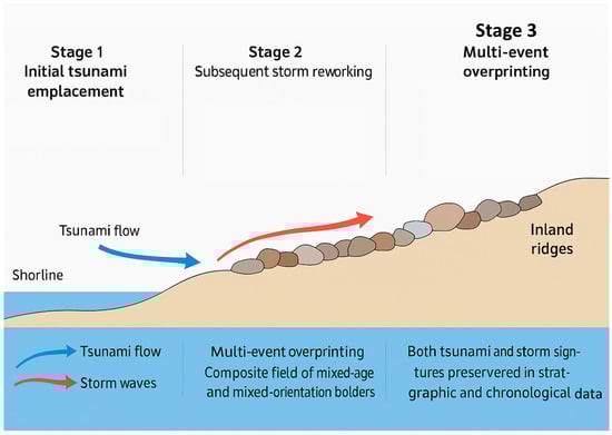
Figure 2.
Conceptual model illustrating the formation and reworking of mixed-origin (polygenetic) coastal boulder deposits (CBDs).
Field evidence from North Africa illustrates this complexity. On Mediterranean coasts, Khalfaoui et al. [173] identified boulders exhibiting contrasting degrees of weathering and imbrication: some consistent with emplacement by a single catastrophic tsunami, others showing fresher surfaces and orientations indicative of reworking by cyclone-driven waves. The result is a composite boulder field, where successive phases of transport are recorded in the spatial arrangement and surface condition of clasts. This highlights how even in relatively confined coastal settings, CBDs can encapsulate the legacy of multiple forcing mechanisms across centuries.
Nandasena et al. [180] combined morpho-topographical surveys, UAV-based photogrammetry, geochronological dating, and hydrodynamic modeling to show that both tsunamis triggered by Venezuelan earthquakes and powerful Atlantic hurricanes contributed to the formation of CBDs across these islands. The coexistence of clasts with differing weathering states, orientations, and depositional contexts points to a polygenetic origin, shaped by episodic overprinting of storm and tsunami processes. This finding challenges earlier interpretations that attributed such assemblages exclusively to either tsunamis or hurricanes, instead highlighting the interplay between the two.
Recent investigations across the Mediterranean basin have provided essential insights that refine the storm–tsunami debate and demonstrate the diversity of depositional mechanisms in semi-enclosed seas. Along the eastern coast of Malta, Biolchi et al. [147] conducted a multidisciplinary study combining geomorphological mapping, hydrodynamic modeling, and radiocarbon dating to evaluate 77 boulders detached from nearshore limestone platforms. Their results revealed that most clasts were mobilized by intense storm waves, although the presence of older encrustations suggested occasional tsunami overprinting, highlighting the coexistence of both mechanisms in the Maltese archipelago. Similarly, in the northern Adriatic, Biolchi et al. [69] documented the first large-scale boulder accumulations at Premantura Promontory (Croatia) using UAV photogrammetry, hydrodynamic modeling, and 14C dating. Their findings attribute emplacement primarily to repeated extreme storm events, facilitated by joint-controlled bedding planes and low coastal relief. Subsequent monitoring of the 2018 Vaia storm confirmed ongoing storm-driven boulder mobility in the same region revealing displacements of up to several meters under modeled wave heights of ~6 m [69,181]. More recently, Korbar et al. [167] reported coarse-clast storm deposits on Mana Island (Central Adriatic), where successive storms, including Vaia produced repeated cliff erosion and multi-event boulder fragmentation. UAV-based analysis indicated fractal fragmentation consistent with cumulative storm activity rather than single-event emplacement. Likewise, Vaccher et al. [182] applied UAV-SfM-MVS photogrammetry to map more than 590 boulders on Fenoliga Island, demonstrating the power of high-resolution geomatics to detect incremental boulder movement across a nine-year monitoring period. These results collectively confirm that recurrent storm impacts in semi-enclosed basins, modulated by local lithological and structural predispositions, can mobilize clasts previously attributed to tsunami events. Finally, outside the Mediterranean, Scardino et al. [183] provide an instructive analog from the ABC Islands (Aruba, Bonaire, Curaçao), where Holocene boulder ridges record alternating tsunami and hurricane emplacement, reinforcing the polygenetic nature of extreme-wave deposits. Together, these studies demonstrate that Mediterranean and subtropical island settings are key natural laboratories for resolving the relative roles of tsunami and storm processes in shaping coastal boulder assemblages.
Untangling the contributions of storms and tsunamis to mixed-origin CBDs requires robust multiproxy approaches. High-resolution topographic methods such as UAV photogrammetry and LiDAR can detect subtle differences in ridge morphology, clast orientation, and cumulative displacement patterns [116]. Chronological tools further refine interpretation: radiocarbon dating of biogenic encrustations and optically stimulated luminescence (OSL) dating of boulder surfaces can constrain emplacement phases across decadal-to-millennial scales [31]. When integrated with historical records of seismicity, cyclone tracks, and paleo-sea-level conditions, these datasets allow reconstruction of multi-event depositional histories and strengthen hazard attribution.
Ultimately, the recognition of polygenetic CBDs emphasizes that these deposits are not always simple, single-event archives, but rather complex stratigraphic records of repeated extreme-wave activity. They embody both the cumulative effects of recurrent storms and the catastrophic imprints of rare tsunamis. This realization calls for interpretative frameworks that move beyond rigid tsunami-versus-storm dichotomies and instead embrace the possibility of multi-event, mixed signatures. Such an approach not only improves the reliability of paleohazard reconstructions but also provides a more realistic appraisal of coastal vulnerability in regions repeatedly exposed to extreme marine forcing.
The synthesis presented in Table 8 reveals systematic contrasts between tsunami- and storm-emplaced CBDs, reflecting fundamental differences in wave dynamics, flow duration, and recurrence regimes.
Table 8.
Comparative synthesis of diagnostic parameters distinguishing tsunami- and storm-emplaced coastal boulder deposits (CBDs) based on global case studies (1991–2025).
Tsunami boulder assemblages are generally characterized by extreme mass and inland penetration, with clasts frequently exceeding 100 t and in exceptional cases reaching more than 3000 t, transported hundreds of meters landward and tens of meters above mean sea level. These features result from the long-period, bore-like nature of tsunami flows, which sustain elevated hydrodynamic pressures for several minutes and enable prolonged traction and suspension of megaclasts. In contrast, storm-related deposits are typically smaller in scale, seldom surpassing 200 t, and display more discontinuous and spatially heterogeneous distributions, consistent with short-period oscillatory waves whose energy is modulated by infragravity amplification, tidal phase, and local platform morphology.
Chronological evidence also reinforces this dichotomy: tsunami deposits commonly exhibit centennial- to millennial-scale recurrence intervals recorded through radiocarbon, optically stimulated luminescence, or cosmogenic exposure dating, whereas storm deposits often correspond to modern or historical events, showing sub-decadal emplacement ages and partial reworking over successive storm seasons. Morphological criteria such as ridge continuity, bidirectional imbrication, and the presence of paired landward–seaward orientations remain strong indicators of tsunami forcing, while irregular clustering, landward-dipping imbrication, and fragmented ridge geometries are more consistent with cumulative storm activity.
Overall, these global patterns confirm that while the two processes may overlap in transport competence, their geomorphic and chronological fingerprints remain distinguishable when assessed through a multi-proxy framework integrating morphology, chronology, hydrodynamics, and site context. The consistent trends observed across geographically diverse coastlines, from the Mediterranean to the Pacific and North Atlantic strengthen the diagnostic reliability of such integrated approaches and underscore the necessity of combining quantitative modeling with precise field documentation to discriminate between tsunami and storm origins in future CBD research.
8. Future Research Directions
The review of global CBD research between 1991 and 2025 reveals several persistent methodological and conceptual gaps that limit the precision of event attribution and the generalization of results across coastal settings. Addressing these deficiencies requires interdisciplinary strategies that combine geomorphology, hydrodynamics, geochronology, and data science. Table 9 summarizes the principal knowledge gaps identified in this synthesis, along with recommended methodological approaches designed to overcome them.
Table 9.
Identified knowledge gaps and proposed research directions for advancing CBD studies based on global literature (1991–2025).
Future work on CBDs must address existing methodological uncertainties while enhancing the temporal resolution of depositional histories. A priority is the development of global reference databases compiling morphometric, chronological, and contextual data from well-documented sites. Such repositories would enable inter-site comparisons, calibration of transport equations, and global meta-analyses. Methodological innovation is equally vital. Advances in three-dimensional numerical modeling by integrating detailed bathymetry, coastal topography, and physically based hydrodynamics offer the potential for more realistic reconstructions of run-up, flow velocity, and backwash. Sensitivity testing of such models could help constrain uncertainty and provide standardized benchmarks for storm versus tsunami attribution. Chronological refinement remains another frontier. Integrating multiple techniques such as radiocarbon, OSL, cosmogenic nuclides will help establish more precise timelines of emplacement and distinguish between single-event and cumulative storm impacts. In parallel, the development of standardized diagnostic criteria that clearly separate storm, tsunami, and mixed-origin deposits would reduce interpretive subjectivity and improve reproducibility across studies. Finally, future research should couple onshore evidence with offshore archives. Submarine landslide mapping, marine sediment coring, and paleoseismological trenching can establish causal links between CBDs and their triggering events, thereby bridging the gap between coastal geomorphology and geophysical hazard research. Such integrative efforts will advance understanding of CBD dynamics and refine models of long-term coastal evolution under both climatic and tectonic forcing.
9. Conclusions
CBDs represent some of the most striking and scientifically valuable archives of extreme-wave activity preserved along rocky shorelines. Beyond their geomorphic distinctiveness, these deposits serve as natural recorders of coastal hazards extending far beyond the timescales of instrumental and historical documentation. Their study bridges geology, oceanography, and hazard science, offering critical insights into the recurrence, magnitude, and impact of both tsunamigenic and storm-driven processes that shape coastal landscapes.
This review has synthesized current global knowledge on CBDs, addressing their origins, dynamics, diagnostic criteria, and the evolving toolbox of analytical and monitoring techniques. The discussion of extreme forcing highlighted the contrasting yet occasionally overlapping hydrodynamic signatures of tsunamis characterized by long-period, bore-like surges generated by seismic, volcanic, or landslide triggers and storm waves, which operate on shorter timescales but can be amplified through infragravity coupling, tidal surges, and rising sea levels. The mechanics of dislodgement and transport emphasized the interplay between geological predisposition, hydrodynamic forcing, and transport modes. Early IoM formulations provided baseline thresholds, yet newer dynamic, impulse-based, and time-varying models have demonstrated that short-duration, high-intensity surges can achieve transport under conditions previously deemed insufficient. These refinements caution against simplistic back-calculations of wave height from boulder size alone.
Diagnostic morphology, once the cornerstone of CBD interpretation, has been reevaluated through field evidence and laboratory experiments showing that storm waves can reproduce many features previously considered diagnostic of tsunamis, such as inland reach, ridge geometry, and coherent imbrication. Case studies from Ireland, Portugal, and the Philippines illustrate that severe storms are capable of displacing megaclasts comparable to those attributed to tsunamis, challenging conventional classification criteria. Meanwhile, tsunami-emplaced boulders from the Canary Islands, Sakishima Islands, Oman, and Chile provide unequivocal evidence of catastrophic inundations capable of mobilizing hundreds of tonnes to elevations exceeding 20 m above sea level. The recognition of polygenetic or mixed-origin deposits further underscores the complexity of CBD assemblages, where repeated storm and tsunami events leave overprinted, multi-generational signatures that record the long-term history of coastal extreme events.
Recent methodological advances, including high-resolution geomatics (RTK-GPS, UAV-SfM, TLS, LiDAR), chronological dating (radiocarbon, cosmogenic nuclides, OSL, VRM), and integrated numerical and physical modeling, have transformed the discipline. These approaches now allow for centimeter-scale monitoring of boulder movement, precise temporal reconstruction of multi-event histories, and realistic simulation of wave–boulder interactions. The incorporation of sea-level rise projections and climate-change scenarios has further elevated CBD research from a purely geomorphic inquiry to a critical component of coastal hazard and resilience assessment.
Ultimately, the study of coastal boulder deposits transcends traditional boundaries between geomorphology and hazard science. CBDs function as high-resolution geological archives capable of revealing the interplay between rare catastrophic events and long-term coastal evolution. By developing standardized, multiproxy frameworks that integrate morphology, chronology, hydrodynamic modeling, and site context, future research can refine the diagnostic reliability of CBDs and their use in probabilistic hazard modeling. In an era marked by accelerating sea-level rise, intensifying storm regimes, and continued tectonic and volcanic activity, advancing CBD research is not only essential for reconstructing the past but also for anticipating the future behavior of high-energy coastlines and improving global coastal risk preparedness.
Author Contributions
Conceptualization, A.G., H.S. and N.M.; methodology, A.G., H.S. and N.M.; validation, A.G. and N.M.; writing—original draft preparation, A.G., H.S., M.O.L. and N.M.; writing—review and editing, A.G., H.S., M.O.L. and N.M.; supervision, N.M.; funding acquisition, A.G. All authors have read and agreed to the published version of the manuscript.
Funding
This research received no external funding.
Data Availability Statement
The original contributions presented in this study are included in the article. Further inquiries can be directed to the corresponding author.
Acknowledgments
The authors would like to thank all those who collaborated in this work with the data analysis, and writing manuscript.
Conflicts of Interest
The authors declare no conflicts of interest.
References
- Causon-Deguara, J.; Gauci, R.; Inkpen, R. Coastal Boulder Deposits in the Mediterranean: A Comprehensive Review of Research and Findings. Mediterr. Geosci. Rev. 2025, 7, 255–274. [Google Scholar] [CrossRef]
- Cox, R.; Bourke, M.C.; Engel, M.; Kennedy, A.B.; Lau, A.; Suanez, S.; Boulton, S.J.; Oliveira, M.A.; Paris, R.; Salmanidou, D.; et al. Understanding Extreme-Wave Hazards on High-Energy Coasts Requires a Standardised Approach to Field Data Collection: Analysis and Recommendations. EGUsphere 2025, 2025, 1913. [Google Scholar] [CrossRef]
- Gharnate, A.; Taouali, O.; Mhammdi, N. Shoreline Change Assessment of the Moroccan Atlantic Coastline Using DSAS Techniques. J. Coast. Res. 2024, 40, 418–435. [Google Scholar] [CrossRef]
- da Costa, P.J.M. Sedimentological Signatures of Extreme Marine Inundations. Ph.D. Thesis, University of Lisbon, Lisboa, Portugal, 2012. [Google Scholar]
- Galindo, I.; Romero, C.; Martín-González, E.; Sánchez, N.; Vegas, J.; Lario, J. An Extreme Wave Event in Timanfaya National Park: Possible First Geological Evidence of the 1755 Lisbon Tsunami in Lanzarote, Canary Islands. Earth Surf. Process. Landf. 2024, 49, 4133–4153. [Google Scholar] [CrossRef]
- Donnelly, J.P. Reconstructing Tropical Cyclone Activity from Sedimentary Archives. Annu. Rev. Earth Planet. Sci. 2025, 53, 251–281. [Google Scholar] [CrossRef]
- Switzer, A.D. Coastal Hazards: Storms and Tsunamis. In Coastal Environments and Global Change; John Wiley & Sons: Hoboken, NJ, USA, 2015; pp. 104–127. [Google Scholar]
- Engel, M.; May, S.M.; Pilarczyk, J.; Brill, D.; Garrett, E. Geological Records of Tsunamis and Other Extreme Waves: Concepts, Applications and a Short History of Research. In Geological Records of Tsunamis and Other Extreme Waves; Elsevier: Amsterdam, The Netherlands, 2020; pp. 3–20. [Google Scholar]
- Elko, N.; Dietrich, C.; Cialone, M.; Stockdon, H.; Bilskie, M.W.; Boyd, B.; Charbonneau, B.; Cox, D.; Dresback, K.; Elgar, S. Advancing the Understanding of Storm Processes and Impacts. Shore Beach 2019, 87, 37–51. [Google Scholar]
- Naylor, L.A.; Spencer, T.; Lane, S.N.; Darby, S.E.; Magilligan, F.J.; Macklin, M.G.; Möller, I. Stormy Geomorphology: Geomorphic Contributions in an Age of Climate Extremes. Earth Surf. Process. Landf. 2017, 42, 166–190. [Google Scholar] [CrossRef]
- Wright, L.D.; Thom, B.G. Coastal Morphodynamics and Climate Change: A Review of Recent Advances. J. Mar. Sci. Eng. 2023, 11, 1997. [Google Scholar] [CrossRef]
- Nott, J. Extremely High-Energy Wave Deposits inside the Great Barrier Reef, Australia: Determining the Cause—Tsunami or Tropical Cyclone. Mar. Geol. 1997, 141, 193–207. [Google Scholar] [CrossRef]
- Nott, J. Tsunami or Storm Waves?—Determining the Origin of a Spectacular Field of Wave Emplaced Boulders Using Numerical Storm Surge and Wave Models and Hydrodynamic Transport Equations. J. Coast. Res. 2003, 19, 348–356. [Google Scholar]
- Goto, K.; Chavanich, S.A.; Imamura, F.; Kunthasap, P.; Matsui, T.; Minoura, K.; Sugawara, D.; Yanagisawa, H. Distribution, Origin and Transport Process of Boulders Deposited by the 2004 Indian Ocean Tsunami at Pakarang Cape, Thailand. Sediment. Geol. 2007, 202, 821–837. [Google Scholar] [CrossRef]
- Mhammdi, N.; Medina, F.; Kelletat, D.; Ahmamou, M.; Aloussi, L. Large Boulders along the Rabat Coast (Morocco); Possible Emplacement by the November, 1st, 1755 A.D. Tsunami. Sci. Tsunami Hazards 2008, 27, 17–30. [Google Scholar]
- De Martini, P.M.; Pantosti, D.; Sakellariou, D.; Camerlenghi, A. Historical and Pre-Historical Tsunamis in the Mediterranean and Its Connected Seas: Geological Signatures, Generation…. Mar. Geol. 2014, 354, 81–109. [Google Scholar] [CrossRef]
- Dewey, J.F.; Ryan, P.D. Storm, Rogue Wave, or Tsunami Origin for Megaclast Deposits in Western Ireland and North Island, New Zealand? Proc. Natl. Acad. Sci. USA 2017, 114, E10639–E10647. [Google Scholar] [CrossRef] [PubMed]
- Cox, R.; Jahn, K.L.; Watkins, O.G.; Cox, P. Extraordinary Boulder Transport by Storm Waves (West of Ireland, Winter 2013–2014), and Criteria for Analysing Coastal Boulder Deposits. Earth-Sci. Rev. 2018, 177, 623–636. [Google Scholar] [CrossRef]
- Leijnse, T.W.; van Ormondt, M.; van Dongeren, A.; Aerts, J.C.; Muis, S. Estimating Nearshore Infragravity Wave Conditions at Large Spatial Scales. Front. Mar. Sci. 2024, 11, 1355095. [Google Scholar] [CrossRef]
- Scheffers, A.; Kelletat, D.; Haslett, S.; Scheffers, S.; Browne, T. Coastal Boulder Deposits in Galway Bay and the Aran Islands, Western Ireland. Z. Für Geomorphologie. Suppl. 2010, 54, 247. [Google Scholar] [CrossRef]
- Antunes, C.; Rocha, C.; Catita, C. Coastal Flood Assessment Due to Sea Level Rise and Extreme Storm Events: A Case Study of the Atlantic Coast of Portugal’s Mainland. Geosciences 2019, 9, 239. [Google Scholar] [CrossRef]
- Dewey, J.; Goff, J.; Ryan, P. The Origins of Marine and Non-Marine Boulder Deposits: A Brief Review. Nat. Hazards 2021, 109, 1981–2002. [Google Scholar] [CrossRef]
- Lin, J.-H.; Chang, Y.-W.; Chen, G.-Y. Boulder Transportation on the Flat Bed by Dam Break. J. Earthq. Tsunami 2022, 16, 2241002. [Google Scholar] [CrossRef]
- Barrocu, G.; Eslamian, S. Geomorphology and Flooding. In Flood Handbook; CRC Press: Boca Raton, FL, USA, 2022; pp. 23–54. [Google Scholar]
- Houseago, R.; Hodge, R.; Asher, B.; Ferguson, R.; Hackney, C.; Hardy, R.; Hoey, T.; Johnson, J.; Rice, S.; Yager, E. Quantifying Bed Surface Roughness in Bedrock and Boulder-bed Rivers. J. Geophys. Res. Earth Surf. 2025, 130, e2024JF007996. [Google Scholar] [CrossRef]
- Altomare, C.; Tafuni, A.; Domínguez, J.M.; Crespo, A.J.; Gironella, X.; Sospedra, J. SPH Simulations of Real Sea Waves Impacting a Large-Scale Structure. J. Mar. Sci. Eng. 2020, 8, 826. [Google Scholar] [CrossRef]
- Torres-Freyermuth, A.; Medellin, G.; Martin, G.U.; Puleo, J.A. A Virtual Laboratory for Conducting “Hands-on” Experiments on Water Wave Mechanics. Cont. Shelf Res. 2022, 243, 104760. [Google Scholar] [CrossRef]
- Boesl, F.; Engel, M.; Eco, R.C.; Galang, J.B.; Gonzalo, L.A.; Llanes, F.; Quix, E.; Brückner, H. Digital Mapping of Coastal Boulders–High-resolution Data Acquisition to Infer Past and Recent Transport Dynamics. Sedimentology 2020, 67, 1393–1410. [Google Scholar] [CrossRef]
- Jones, L.; Hobbs, P. The Application of Terrestrial LiDAR for Geohazard Mapping, Monitoring and Modelling in the British Geological Survey. Remote Sens. 2021, 13, 395. [Google Scholar] [CrossRef]
- Ok, E. Traditional Surveying vs. UAV Drone-Based Structure-from-Motion Advancements in Topographical Mapping Accuracy and Efficiency. 2025. Available online: https://www.researchgate.net/publication/388177304_Traditional_Surveying_vs_UAV_Drone-Based_Structure-from-Motion_Advancements_in_Topographical_Mapping_Accuracy_and_Efficiency (accessed on 22 July 2025).
- Brill, D.; May, S.M.; Mhammdi, N.; King, G.; Lehmann, B.; Burow, C.; Wolf, D.; Zander, A.; Brückner, H. Evaluating Optically Stimulated Luminescence Rock Surface Exposure Dating as a Novel Approach for Reconstructing Coastal Boulder Movement on Decadal to Centennial Timescales. Earth Surf. Dyn. 2021, 9, 205–234. [Google Scholar] [CrossRef]
- Marras, S.; Mandli, K.T. Modeling and Simulation of Tsunami Impact: A Short Review of Recent Advances and Future Challenges. Geosciences 2021, 11, 5. [Google Scholar] [CrossRef]
- Lee, C.-H.; Lo, P.H.-Y.; Shi, H.; Huang, Z. Numerical Modeling of Generation of Landslide Tsunamis: A Review. J. Earthq. Tsunami 2022, 16, 2241001. [Google Scholar] [CrossRef]
- Jazaeri, S.A.; Nistor, I.; Mohammadian, A.; Liu, X. A Critical Review on the Tsunami-Induced Scour around Structures. Coast. Eng. J. 2024, 66, 563–590. [Google Scholar] [CrossRef]
- Cukur, D.; Wang, X.; Micallef, A.; Horozal, S.; Um, I.-K.; Kong, G.-S.; Kim, S.-P.; Liu, Y. Tsunami Hazard Potential of Submarine Landslides in the Southwestern East Sea (Sea of Japan). Nat. Hazards 2025, 121, 16447–16479. [Google Scholar] [CrossRef]
- Medina, F.; Mhammdi, N.; Chiguer, A.; Akil, M.; Jaaidi, E. The Rabat and Larache Boulder Fields; New Examples of High-Energy Deposits Related to Storms and Tsunami Waves in North-Western Morocco. Nat. Hazards 2011, 59, 725–747. [Google Scholar] [CrossRef]
- Köhler, M.; Lau, A.; Nakata, K.; Goto, K.; Goff, J.; Köhler, D.; Penisoni, M. Discovery of the World’s Largest Cliff-Top Boulder: Initial Insights and Numerical Simulation of Its Transport on a 30–40 m High Cliff on Tongatapu (Tonga). Mar. Geol. 2025, 487, 107567. [Google Scholar] [CrossRef]
- Song, L.; An, C. Extraction of Tsunami Signals from Coupled Seismic and Tsunami Waves. J. Mar. Sci. Eng. 2025, 13, 419. [Google Scholar] [CrossRef]
- Sarkawi, G.M.; Feng, L.; McCaughey, J.W.; Meltzner, A.J.; Susilo, S.; Muksin, U.; Socquet, A.; Oktari, R.S.; Adi, S.P.; Bürgmann, R. Insights into Tectonic Hazards since the 2004 Indian Ocean Earthquake and Tsunami. Nat. Rev. Earth Environ. 2025, 6, 17–34. [Google Scholar] [CrossRef]
- Mavroulis, S.; Mavrouli, M.; Sarantopoulou, A.; Antonarakou, A.; Lekkas, E. Increased Preparedness During the 2025 Santorini–Amorgos (Greece) Earthquake Swarm and Comparative Insights from Recent Cases for Civil Protection and Disaster Risk Reduction. GeoHazards 2025, 6, 32. [Google Scholar] [CrossRef]
- Androsov, A.; Harig, S.; Fuchs, A.; Immerz, A.; Rakowsky, N.; Hiller, W.; Danilov, S. Tsunami Wave Propagation. In Wave Propagation Theories and Applications; IntechOpen: London, UK, 2025. [Google Scholar]
- Farahmandpour, O.; Marsono, A.K.; Forouzani, P.; Tap, M.M.; Abu Bakar, S. Experimental Simulation of Tsunami Surge and Its Interaction with Coastal Structure. Int. J. Prot. Struct. 2020, 11, 258–280. [Google Scholar] [CrossRef]
- Sugawara, D.; Goto, K.; Jaffe, B.E. Numerical Models of Tsunami Sediment Transport—Current Understanding and Future Directions. Mar. Geol. 2014, 352, 295–320. [Google Scholar] [CrossRef]
- Cas, R.; Wright, J.V.; Giordano, G. Surface Sedimentary (Epiclastic) Processes and Deposits in Volcanic Environments: Response to Volcanic Events, and Reconstructing Paleo-Volcanic Settings. In Volcanology: Processes, Deposits, Geology and Resources; Springer: Berlin/Heidelberg, Germany, 2024; pp. 985–1078. [Google Scholar]
- Costa, P.J.; Andrade, C. Tsunami Deposits: Present Knowledge and Future Challenges. Sedimentology 2020, 67, 1189–1206. [Google Scholar] [CrossRef]
- Nguyen, A. Sedimentological Reconstruction of Hurricane Storm Surges from a Carbonate Reef Coastline at Anegada, British Virgin Islands. Master’s Thesis, Simon Fraser University, Burnaby, BC, Canada, 2025. [Google Scholar]
- Nesteckytė, L.; Stankūnavičius, G.; Kelpšaitė-Rimkienė, L.; Šepić, J. 2023 November Storm in the Port of Klaipeda; Why Was the Port Closed? Pure Appl. Geophys. 2024, 181, 3173–3188. [Google Scholar] [CrossRef]
- Emerson, O.D. Assessment of Dune Change Using Historical Aerial and Satellite Photos, Topographic Surveys, and Wave Data at Toro Creek Beach. Master’s Thesis, California Polytechnic State University, San Luis Obispo, CA, USA, 2024. [Google Scholar]
- Bourman, R.; Murray-Wallace, C.; Panda, D.; Buckman, S.; Banerjee, D.; Ryan, D.; White, L. Tsunami or Storm? A High-Level Coastal Boulder Field on the Southern Tip of Eyre Peninsula, South Australia. Aust. J. Earth Sci. 2024, 71, 52–66. [Google Scholar] [CrossRef]
- Karagiorgos, J.; Patlakas, P.; Vervatis, V.; Sofianos, S. The Role of Ocean Penetrative Solar Radiation in the Evolution of Mediterranean Storm Daniel. Remote Sens. 2025, 17, 2684. [Google Scholar] [CrossRef]
- May, S.M.; Engel, M.; Brill, D.; Squire, P.; Scheffers, A.; Kelletat, D. Coastal Hazards from Tropical Cyclones and Extratropical Winter Storms Based on Holocene Storm Chronologies. In Coastal Hazards; Springer: Berlin, Germany, 2012; pp. 557–585. [Google Scholar]
- Flaounas, E.; Davolio, S.; Raveh-Rubin, S.; Pantillon, F.; Miglietta, M.M.; Gaertner, M.A.; Hatzaki, M.; Homar, V.; Khodayar, S.; Korres, G. Mediterranean Cyclones: Current Knowledge and Open Questions on Dynamics, Prediction, Climatology and Impacts. Weather Clim. Dyn. 2022, 3, 173–208. [Google Scholar] [CrossRef]
- Kennedy, A.B.; Cox, R.; Dias, F. Storm Waves May Be the Source of Some “Tsunami” Coastal Boulder Deposits. Geophys. Res. Lett. 2021, 48, e2020GL090775. [Google Scholar] [CrossRef] [PubMed]
- Erdmann, W.; Kelletat, D.; Kuckuck, M. Boulder Ridges and Washover Features in Galway Bay, Western Ireland. J. Coast. Res. 2017, 33, 997–1021. [Google Scholar] [CrossRef]
- Weiss, R.; Diplas, P. Untangling Boulder Dislodgement in Storms and Tsunamis: Is It Possible with Simple Theories? Geochem. Geophys. Geosystems 2015, 16, 890–898. [Google Scholar] [CrossRef]
- Souza, J.; Dandenault, P.; Santos, A.; Riccobono, J.; Migliozzi, M.; Kapali, S.; Kerr, R.; Mesquita, R.; Batista, I.; Wu, Q. Impacts of Storm Electric Fields and Traveling Atmospheric Disturbances over the Americas during 23–24 April 2023 Geomagnetic Storm: Experimental Analysis. J. Geophys. Res. Space Phys. 2024, 129, e2024JA032698. [Google Scholar] [CrossRef]
- Oh, J.-E.; Jeong, W.-M.; Chang, Y.S.; Oh, S.-H. On the Separation Period Discriminating Gravity and Infragravity Waves off Gyeongpo Beach, Korea. J. Mar. Sci. Eng. 2020, 8, 167. [Google Scholar] [CrossRef]
- Cox, R.; Ardhuin, F.; Dias, F.; Autret, R.; Beisiegel, N.; Earlie, C.; Herterich, J.; Kennedy, A.; Paris, R.; Raby, A.; et al. Systematic Review Shows That Work Done by Storm Waves Can Be Misinterpreted as Tsunami-Related Because Commonly Used Hydrodynamic Equations Are Flawed. Front. Mar. Sci. 2020, 7, 4. [Google Scholar] [CrossRef]
- Thompson, C.; Young, A.; Dickson, M. Wave Impacts on Coastal Cliffs: Do Bigger Waves Drive Greater Ground Motion? Earth Surf. Process. Landf. 2019, 44, 2849–2860. [Google Scholar] [CrossRef]
- Priestley, M.D.; Catto, J.L. Future Changes in the Extratropical Storm Tracks and Cyclone Intensity, Wind Speed, and Structure. Weather Clim. Dyn. Discuss. 2021, 3, 337–360. [Google Scholar] [CrossRef]
- Leszczyńska, K.; Alexanderson, H.; Clemmensen, L.B.; Giza, A.; Lorenz, S.; Moskalewicz, D.; Oliński, P.; Paprotny, D.; Rosentau, A.; Rutgersson, A.; et al. A Review of Storms and Marine Coastal Flooding in the Baltic Sea–Insights from Instrumental, Historical and Sedimentary Record. Earth-Sci. Rev. 2025, 266, 105137. [Google Scholar] [CrossRef]
- Masselink, G.; Brooks, S.; Poate, T.; Stokes, C.; Scott, T. Coastal Dune Dynamics in Embayed Settings with Sea-Level Rise–Examples from the Exposed and Macrotidal North Coast of SW England. Mar. Geol. 2022, 450, 106853. [Google Scholar] [CrossRef]
- Vousdoukas, M.I.; Mentaschi, L.; Voukouvalas, E.; Verlaan, M.; Jevrejeva, S.; Jackson, L.P.; Feyen, L. Global Probabilistic Projections of Extreme Sea Levels Show Intensification of Coastal Flood Hazard. Nat. Commun. 2018, 9, 2360. [Google Scholar] [CrossRef] [PubMed]
- Knutson, T.; Camargo, S.J.; Chan, J.C.L.; Emanuel, K.; Ho, C.-H.; Kossin, J.; Mohapatra, M.; Satoh, M.; Sugi, M.; Walsh, K.; et al. Tropical Cyclones and Climate Change Assessment: Part II: Projected Response to Anthropogenic Warming. Bull. Am. Meteorol. Soc. 2020, 101, E303–E322. [Google Scholar] [CrossRef]
- Hoeke, R.K.; McInnes, K.L.; Kruger, J.C.; McNaught, R.J.; Hunter, J.R.; Smithers, S.G. Widespread Inundation of Pacific Islands Triggered by Distant-Source Wind-Waves. Glob. Planet. Change 2013, 108, 128–138. [Google Scholar] [CrossRef]
- Haider, R.; Ali, S.; Hoffmann, G.; Reicherter, K. Tsunami Inundation and Vulnerability Analysis on the Makran Coast, Pakistan. Nat. Hazards Earth Syst. Sci. 2024, 24, 3279–3290. [Google Scholar] [CrossRef]
- Han, H.; Liu, H.; Chan, A.; Mcmanus, T. Three-Dimensional Finite Element Modelling of Excavation-Induced Tunnel Wall Movement and Damage: A Case Study. Sādhanā 2019, 44, 185. [Google Scholar] [CrossRef]
- Oliveira, M.A.; Scotto, M.G.; Barbosa, S.; de Andrade, C.F.; da Conceição Freitas, M. Morphological Controls and Statistical Modelling of Boulder Transport by Extreme Storms. Mar. Geol. 2020, 426, 106216. [Google Scholar] [CrossRef]
- Biolchi, S.; Furlani, S.; Devoto, S.; Scicchitano, G.; Korbar, T.; Vilibić, I.; Šepić, J. The Origin and Dynamics of Coastal Boulders in a Semi-Enclosed Shallow Basin: A Northern Adriatic Case Study. Mar. Geol. 2019, 411, 62–77. [Google Scholar] [CrossRef]
- Corradino, M.; Faraci, C.; Monaco, C.; Pepe, F. Coastal Boulder Production Controlled by Columnar Joints of Ignimbrite and Extreme Waves: Insights from the High-Energy Coast of Pantelleria Island (Sicily Channel, Mediterranean Sea). Nat. Hazards 2025, 121, 3621–3655. [Google Scholar] [CrossRef]
- Andriani, G.F.; Loiotine, L. Multidisciplinary Approach for Assessment of the Factors Affecting Geohazard in Karst Valley: The Case Study of Gravina Di Petruscio (Apulia, South Italy). Environ. Earth Sci. 2020, 79, 458. [Google Scholar] [CrossRef]
- Cas, R.; Wright, J.V.; Giordano, G. Terminology for Volcanic Deposits and Rocks: Descriptive to Genetic Nomenclature, with Key Observations and Steps. In Volcanology: Processes, Deposits, Geology and Resources; Springer: Berlin/Heidelberg, Germany, 2024; pp. 1121–1160. [Google Scholar]
- Moses, C.A. Rock Coast Geomodel: Process–Response Dynamics, Resilience and Vulnerability. Geol. Soc. Lond. Eng. Geol. Spec. Publ. 2025, 30, 209–235. [Google Scholar] [CrossRef]
- Davidson, T.M.; Altieri, A.H.; Ruiz, G.M.; Torchin, M.E. Bioerosion in a Changing World: A Conceptual Framework. Ecol. Lett. 2018, 21, 422–438. [Google Scholar] [CrossRef] [PubMed]
- Dasgupta, P. Sediment Gravity Flow—The Conceptual Problems. Earth-Sci. Rev. 2003, 62, 265–281. [Google Scholar] [CrossRef]
- Maniatis, G.; Hoey, T.; Hodge, R.; Rickenmann, D.; Badoux, A. Inertial Drag and Lift Forces for Coarse Grains on Rough Alluvial Beds Measured Using In-Grain Accelerometers. Earth Surf. Dyn. 2020, 8, 1067–1099. [Google Scholar] [CrossRef]
- Anand, A.; Beg, M.; Kumar, N. Experimental Studies and Analysis on Mobilization of the Cohesionless Sediments through Alluvial Channel: A Review. Civ. Eng. J. 2021, 7, 915–936. [Google Scholar] [CrossRef]
- Nandasena, N.A.K.; Paris, R.; Tanaka, N. Reassessment of Hydrodynamic Equations: Minimum Flow Velocity to Initiate Boulder Transport by High Energy Events (Storms, Tsunamis). Mar. Geol. 2011, 281, 70–84. [Google Scholar] [CrossRef]
- Pérez-Alberti, A.; Trenhaile, A.S. An Initial Evaluation of Drone-based Monitoring of Boulder Beaches in Galicia, North-western Spain. Earth Surf. Process. Landf. 2015, 40, 105–111. [Google Scholar] [CrossRef]
- Weiss, R. The Mystery of Boulders Moved by Tsunamis and Storms. Mar. Geol. 2012, 295–298, 28–33. [Google Scholar] [CrossRef]
- Nandasena, N.A.K. Chapter 29—Perspective of Incipient Motion Formulas: Boulder Transport by High-Energy Waves. In Geological Records of Tsunamis and Other Extreme Waves; Engel, M., Pilarczyk, J., May, S.M., Brill, D., Garrett, E., Eds.; Elsevier: Amsterdam, The Netherlands, 2020; pp. 641–659. ISBN 978-0-12-815686-5. [Google Scholar]
- Kang, H.J. Cross-Shore Sediment Transport in Relation to Waves and Currents in a Groin Compartment; Old Dominion University: Norfolk, VA, USA, 1987; ISBN 979-8-206-27913-9. [Google Scholar]
- Sha, S.; Dyson, A.P.; Kefayati, G.; Tolooiyan, A. Modelling of Debris Flow-Boulder-Barrier Interactions Using the Coupled Eulerian Lagrangian Method. Appl. Math. Model. 2024, 127, 143–171. [Google Scholar] [CrossRef]
- van Aken, J. Earth Observation-Driven Analysis of Flood Extent in Mangrove Areas under Tropical Storms. Master’s Thesis, Delft University of Technology, Delft, The Netherlands, 2025. [Google Scholar]
- Newman, J.N. Marine Hydrodynamics; The MIT press: Cambridge, MA, USA, 2018; ISBN 0-262-53482-7. [Google Scholar]
- Cox, R. Megagravel Deposits on the West Coast of Ireland Show the Impacts of Severe Storms. Weather 2020, 75, 72–77. [Google Scholar] [CrossRef]
- Wang, F.Z.; Animasaun, I.; Muhammad, T.; Okoya, S. Recent Advancements in Fluid Dynamics: Drag Reduction, Lift Generation, Computational Fluid Dynamics, Turbulence Modelling, and Multiphase Flow. Arab. J. Sci. Eng. 2024, 49, 10237–10249. [Google Scholar] [CrossRef]
- Zhang, B.; Deng, A.; Wang, D.; Shi, Y.; Dong, X. Numerical Analysis of Motion Characteristics of Sliding or Rolling and Saltation of Sediment Particles under Turbulent Flow. Water 2022, 14, 1506. [Google Scholar] [CrossRef]
- Herterich, J.; Dias, F. Potential Flow over a Submerged Rectangular Obstacle: Consequences for Initiation of Boulder Motion. Eur. J. Appl. Math. 2020, 31, 646–681. [Google Scholar] [CrossRef]
- Stols, K. Incipient Motion of Boulders in Open Channel Flow. Ph.D. Thesis, University of the Witwatersrand, Johannesburg, South Africa, 2018. [Google Scholar]
- Cox, R.; o’Boyle, L.; Cytrynbaum, J. Imbricated Coastal Boulder Deposits Are Formed by Storm Waves, and Can Preserve a Long-Term Storminess Record. Sci. Rep. 2019, 9, 10784. [Google Scholar] [CrossRef] [PubMed]
- Liu, F.; Hu, N.; Sun, G.; Yang, B. Study on the Influence of Rock Shape on Rolling Distance. Appl. Sci. 2023, 13, 11351. [Google Scholar] [CrossRef]
- Nott, J. Waves, Coastal Boulder Deposits and the Importance of the Pre-Transport Setting. Earth Planet. Sci. Lett. 2003, 210, 269–276. [Google Scholar] [CrossRef]
- Miller, G. Impulse Waves Generated by Gravitationally-Accelerated Granular Landslides in a Large Scale Flume. Master’s Thesis, Queen’s University, Kingston, ON, Canada, 2016. [Google Scholar]
- Watanabe, M.; Goto, K.; Imamura, F.; Hongo, C. Numerical Identification of Tsunami Boulders and Estimation of Local Tsunami Size at Ibaruma Reef of Ishigaki Island, Japan. Isl. Arc 2016, 25, 316–332. [Google Scholar] [CrossRef]
- Erdmann, W.; Kelletat, D.; Scheffers, A.; Haslett, S.K. Origin and Formation of Coastal Boulder Deposits at Galway Bay and the Aran Islands, Western Ireland; Springer: Berlin/Heidelberg, Germany, 2015; ISBN 3-319-16333-7. [Google Scholar]
- Bryant, E.A.; Young, R.W.; Price, D.M. Tsunami as a Major Control on Coastal Evolution, Southeastern Australia. J. Coast. Res. 1996, 12, 831–840. [Google Scholar]
- Billson, O.; Russell, P.; Davidson, M. Storm Waves at the Shoreline: When and Where Are Infragravity Waves Important? J. Mar. Sci. Eng. 2019, 7, 139. [Google Scholar] [CrossRef]
- Cheriton, O.M.; Storlazzi, C.D.; Rosenberger, K.J. Observations of Wave Transformation over a Fringing Coral Reef and the Importance of Low-Frequency Waves and Offshore Water Levels to Runup, Overwash, and Coastal Flooding. J. Geophys. Res. Ocean. 2016, 121, 3121–3140. [Google Scholar] [CrossRef]
- McGovern, D.J.; Allsop, W.; Rossetto, T.; Chandler, I. Large-Scale Experiments on Tsunami Inundation and Overtopping Forces at Vertical Sea Walls. Coast. Eng. 2023, 179, 104222. [Google Scholar] [CrossRef]
- Sanad, H.; Oueld lhaj, M.; Zouahri, A.; Saafadi, L.; Dakak, H.; Mouhir, L. Groundwater Pollution by Nitrate and Salinization in Morocco: A Comprehensive Review. J. Water Health 2024, 22, 1756–1773. [Google Scholar] [CrossRef]
- Sanad, H.; Moussadek, R.; Mouhir, L.; Lhaj, M.O.; Dakak, H.; Manhou, K.; Zouahri, A. Monte Carlo Simulation for Evaluating Spatial Dynamics of Toxic Metals and Potential Health Hazards in Sebou Basin Surface Water. Sci. Rep. 2025, 15, 29471. [Google Scholar] [CrossRef] [PubMed]
- Manhou, K.; Taghouti, M.; Moussadek, R.; Elyacoubi, H.; Bennani, S.; Zouahri, A.; Ghanimi, A.; Sanad, H.; Oueld Lhaj, M.; Hmouni, D.; et al. Performance, Agro-Morphological, and Quality Traits of Durum Wheat (Triticum Turgidum L. Ssp. Durum Desf.) Germplasm: A Case Study in Jemâa Shaïm, Morocco. Plants 2025, 14, 1508. [Google Scholar] [CrossRef]
- Oueld Lhaj, M.; Moussadek, R.; Mouhir, L.; Sanad, H.; Manhou, K.; Iben Halima, O.; Yachou, H.; Zouahri, A.; Mdarhri Alaoui, M. Application of Compost as an Organic Amendment for Enhancing Soil Quality and Sweet Basil (Ocimum Basilicum L.) Growth: Agronomic and Ecotoxicological Evaluation. Agronomy 2025, 15, 1045. [Google Scholar] [CrossRef]
- Sanad, H.; Moussadek, R.; Mouhir, L.; Lhaj, M.O.; Zahidi, K.; Dakak, H.; Manhou, K.; Zouahri, A. Ecological and Human Health Hazards Evaluation of Toxic Metal Contamination in Agricultural Lands Using Multi-Index and Geostatistical Techniques across the Mnasra Area of Morocco’s Gharb Plain Region. J. Hazard. Mater. Adv. 2025, 18, 100724. [Google Scholar] [CrossRef]
- Sanad, H.; Moussadek, R.; Mouhir, L.; Lhaj, M.O.; Dakak, H.; Zouahri, A. Geospatial Analysis of Trace Metal Pollution and Ecological Risks in River Sediments from Agrochemical Sources in Morocco’s Sebou Basin. Sci. Rep. 2025, 15, 16701. [Google Scholar] [CrossRef]
- Hoffmeister, D. Mapping of Subaerial Coarse Clasts. In Geological Records of Tsunamis and Other Extreme Waves; Elsevier: Amsterdam, The Netherlands, 2020; pp. 169–184. [Google Scholar]
- Sedrati, M.; Morales, J.A.; El M’rini, A.; Anthony, E.J.; Bulot, G.; Le Gall, R.; Tadibaght, A. Using UAV and Structure-From-Motion Photogrammetry for the Detection of Boulder Movement by Storms on a Rocky Shore Platform in Laghdira, Northwest Morocco. Remote Sens. 2022, 14, 4102. [Google Scholar] [CrossRef]
- Goodwin, N.; Armston, J.; Muir, J.; Stiller, I. Monitoring Gully Change: A Comparison of Airborne and Terrestrial Laser Scanning Using a Case Study from Aratula, Queensland. Geomorphology 2017, 282, 195–208. [Google Scholar] [CrossRef]
- Vecchi, E. Impact of Geomatic Techniques on Topo-Bathymetric Surveys for Coastal Analysis. Ph.D. Thesis, University of Bologna, Bologna, Italy, 2023. [Google Scholar]
- Shah-Hosseini, M.; Saleem, A.; Mahmoud, A.-M.A.; Morhange, C. Coastal Boulder Deposits Attesting to Large Wave Impacts on the Mediterranean Coast of Egypt. Nat. Hazards 2016, 83, 849–865. [Google Scholar] [CrossRef]
- Roig Munar, F.X.; Martín-Prieto, J.; Rodríguez-Perea, A.; Gelabert, B. Gloria Storm Effects on the Coastal Boulders East of Minorca (Balearic Islands). Environ. Earth Sci. 2023, 82, 176. [Google Scholar] [CrossRef]
- Roig-Munar, F.X.; Gelabert, B.; Rodríguez-Perea, A.; Martín-Prieto, J.Á.; Vilaplana, J.M. Storm or Tsunamis: Boulder Deposits on the Rocky Coasts of the Balearic Islands (Spain). Mar. Geol. 2023, 463, 107112. [Google Scholar] [CrossRef]
- Schneider, B.; Hoffmann, G.; Falkenroth, M.; Grade, J. Tsunami and Storm Sediments in Oman: Characterizing Extreme Wave Deposits Using Terrestrial Laser Scanning. J. Coast. Conserv. 2019, 23, 801–815. [Google Scholar] [CrossRef]
- Nakata, K.; Watanabe, M.; Goto, K. Modelling Emplacement of the World’s Largest Tsunami Boulder. Nat. Hazards 2025, 121, 12169–12193. [Google Scholar] [CrossRef]
- Louis, K.J.; Bellanova, P.; Justen, S.; Kautz, G.; Houbertz, S.; Arianoutsou, A.; Papanikolau, I.; Reicherter, K. Coastal Hazard Assessment Through 3D Mesh Analysis of Coastal Boulder Deposits from Extreme Wave Events in Greece; Copernicus Meetings: Miltenberg, Germany, 2025. [Google Scholar]
- Lindauer, S.; Hadden, C.S.; Macario, K.; Guilderson, T.P. Marine Biogenic Carbonates and Radiocarbon—A Retrospective on Shells and Corals with an Outlook on Challenges and Opportunities. Radiocarbon 2022, 64, 689–704. [Google Scholar] [CrossRef]
- Bromley, G.R.; Thouret, J.-C.; Schimmelpfennig, I.; Mariño, J.; Valdivia, D.; Rademaker, K.; del Pilar Vivanco Lopez, S.; Team, A.; Aumaître, G.; Bourlès, D. In Situ Cosmogenic 3He and 36Cl and Radiocarbon Dating of Volcanic Deposits Refine the Pleistocene and Holocene Eruption Chronology of SW Peru. Bull. Volcanol. 2019, 81, 64. [Google Scholar] [CrossRef]
- Petronis, M.S.; Holm, D.K.; Geissman, J.W.; Hacker, D.B.; Arnold, B.J. Paleomagnetic Results from the Eastern Caliente-Enterprise Zone, Southwestern Utah: Implications for Initiation of a Major Miocene Transfer Zone. Geosphere 2014, 10, 534–563. [Google Scholar] [CrossRef]
- Demirbilek, Z.; Rosati, J. Verification and Validation of the Coastal Modeling System. Report 1: Summary Report. 2011. Available online: https://www.researchgate.net/publication/277766501_Verification_and_Validation_of_the_Coastal_Modeling_System_Report_1_Summary_Report (accessed on 1 August 2025).
- Cozzuto, G.; Saillour, T.; Lupoi, G.; Cuomo, G.; Bourban, S.E. Validation of TELEMAC for Tsunami Inundation Modelling in Compliance with the NOAA-NTHMP Benchmark Test Cases. p. 93. Available online: https://henry.baw.de/items/f064db30-2af2-46a6-9113-d1b4c0b994bd (accessed on 1 August 2025).
- Cauquis, A. Development of a Numerical Model of Dispersive Propagation of Tsunamis. Ph.D. Thesis, Université de Bordeaux, Nouvelle-Aquitaine, France, 2022. [Google Scholar]
- Statler, C.M. A Multi-Scale Numerical Analysis of Wave Propagation Through Coastal Vegetation Using Proteus & XBeach. Master’s Thesis, Louisiana State University, Baton Rouge, LA, USA, 2025. [Google Scholar]
- McCall, R.; Masselink, G.; Poate, T.; Roelvink, J.; Almeida, L.; Davidson, M.; Russell, P. Modelling Storm Hydrodynamics on Gravel Beaches with XBeach-G. Coast. Eng. 2014, 91, 231–250. [Google Scholar] [CrossRef]
- McCall, R.; Masselink, G.; Poate, T.; Roelvink, J.; Almeida, L. Modelling the Morphodynamics of Gravel Beaches during Storms with XBeach-G. Coast. Eng. 2015, 103, 52–66. [Google Scholar] [CrossRef]
- Foster, I.D.L.; Albon, A.J.; Bardell, K.M.; Fletcher, J.L.; Jardine, T.C.; Mothers, R.J.; Pritchard, M.A.; Turner, S.E. High Energy Coastal Sedimentary Deposits; an Evaluation of Depositional Processes in Southwest England. Earth Surf. Process. Landf. 1991, 16, 341–356. [Google Scholar] [CrossRef]
- Mastronuzzi, G.; Sansò, P. Boulders Transport by Catastrophic Waves along the Ionian Coast of Apulia (Southern Italy). Mar. Geol. 2000, 170, 93–103. [Google Scholar] [CrossRef]
- Scheffers, A. Paleotsunami Evidences from Boulder Deposits on Aruba, Curacao and Bonaire. Sci. Tsunami Hazards 2002, 20, 26. [Google Scholar]
- Williams, D.M.; Hall, A.M. Cliff-Top Megaclast Deposits of Ireland, a Record of Extreme Waves in the North Atlantic—Storms or Tsunamis? Mar. Geol. 2004, 206, 101–117. [Google Scholar] [CrossRef]
- Mastronuzzi, G.; Sansò, P. Large Boulder Accumulations by Extreme Waves along the Adriatic Coast of Southern Apulia (Italy). Quat. Int. 2004, 120, 173–184. [Google Scholar] [CrossRef]
- Spiske, M.; Böröcz, Z.; Bahlburg, H. The Role of Porosity in Discriminating between Tsunami and Hurricane Emplacement of Boulders—A Case Study from the Lesser Antilles, Southern Caribbean. Earth Planet. Sci. Lett. 2008, 268, 384–396. [Google Scholar] [CrossRef]
- Goto, K.; Miyagi, K.; Kawamata, H.; Imamura, F. Discrimination of Boulders Deposited by Tsunamis and Storm Waves at Ishigaki Island, Japan. Mar. Geol. 2010, 269, 34–45. [Google Scholar] [CrossRef]
- Barbano, M.; Pirrotta, C.; Gerardi, F. Large Boulders along the South-Eastern Ionian Coast of Sicily: Storm or Tsunami Deposits? Mar. Geol. 2010, 275, 140–154. [Google Scholar] [CrossRef]
- Etienne, S.; Paris, R. Boulder Accumulations Related to Storms on the South Coast of the Reykjanes Peninsula (Iceland). Geomorphology 2010, 114, 55–70. [Google Scholar] [CrossRef]
- Switzer, A.D.; Burston, J.M. Competing Mechanisms for Boulder Deposition on the Southeast Australian Coast. Geomorphology 2010, 114, 42–54. [Google Scholar] [CrossRef]
- Paris, R.; Naylor, L.A.; Stephenson, W.J. Boulders as a Signature of Storms on Rock Coasts. Mar. Geol. 2011, 283, 1–11. [Google Scholar] [CrossRef]
- Costa, P.J.M.; Andrade, C.; Freitas, M.C.; Oliveira, M.A.; da Silva, C.M.; Omira, R.; Taborda, R.; Baptista, M.A.; Dawson, A.G. Boulder Deposition during Major Tsunami Events. Earth Surf. Process. Landf. 2011, 36, 2054–2068. [Google Scholar] [CrossRef]
- Cox, R.; Zentner, D.B.; Kirchner, B.J.; Cook, M.S. Boulder Ridges on the Aran Islands (Ireland): Recent Movements Caused by Storm Waves, Not Tsunamis. J. Geol. 2012, 120, 249–272. [Google Scholar] [CrossRef]
- Scheffers, A.M.; Kinis, S. Stable Imbrication and Delicate/Unstable Settings in Coastal Boulder Deposits: Indicators for Tsunami Dislocation? Quat. Int. 2014, 332, 73–84. [Google Scholar] [CrossRef]
- Causon Deguara, J.; Gauci, R. Boulder and Megaclast Deposits on the South-East Coast of Malta: Signature of Storm or Tsunami Event? 2014. Available online: https://www.um.edu.mt/library/oar/bitstream/123456789/88216/1/Boulder_and_megaclast_deposits_on_the_south_east_coast_of_Malta_2014.pdf (accessed on 28 July 2025).
- Cox, R. RUI: Measuring the Effects of Winter Storms (2013–2014) on the Movement of Boulders in Western Ireland; NSF Award Number 1424668; Directorate for Geosciences: Alexandria, VA, USA, 2014; Volume 14, p. 24668. [Google Scholar]
- Prizomwala, S.P.; Gandhi, D.; Ukey, V.M.; Bhatt, N.; Rastogi, B.K. Coastal Boulders as Evidences of High-Energy Marine Events from Diu Island, West Coast of India: Storm or Palaeotsunami? Nat. Hazards 2015, 75, 1187–1203. [Google Scholar] [CrossRef]
- Hansom, J.D.; Switzer, A.D.; Pile, J. Chapter 11-Extreme Waves: Causes, Characteristics, and Impact on Coastal Environments and Society. In Coastal and Marine Hazards, Risks, and Disasters; Shroder, J.F., Ellis, J.T., Sherman, D.J., Eds.; Hazards and Disasters Series; Elsevier: Boston, MA, USA, 2015; pp. 307–334. ISBN 978-0-12-396483-0. [Google Scholar]
- Shaw, C.E.; Benson, L. Possible Tsunami Deposits on the Caribbean Coast of the Yucatán Peninsula. J. Coast. Res. 2015, 31, 1306–1316. [Google Scholar] [CrossRef]
- Öğretmen, N.; Cosentino, D.; Gliozzi, E.; Cipollari, P.; Iadanza, A.; Yildirim, C. Tsunami Hazard in the Eastern Mediterranean: Geological Evidence from the Anatolian Coastal Area (Silifke, Southern Turkey). Nat. Hazards 2015, 79, 1569–1589. [Google Scholar] [CrossRef]
- May, S.M.; Engel, M.; Brill, D.; Cuadra, C.; Lagmay, A.M.F.; Santiago, J.; Suarez, J.K.; Reyes, M.; Brückner, H. Block and Boulder Transport in Eastern Samar (Philippines) during Supertyphoon Haiyan. Earth Surf. Dyn. 2015, 3, 543–558. [Google Scholar] [CrossRef]
- Biolchi, S.; Furlani, S.; Antonioli, F.; Baldassini, N.; Causon Deguara, J.; Devoto, S.; Di Stefano, A.; Evans, J.; Gambin, T.; Gauci, R.; et al. Boulder Accumulations Related to Extreme Wave Events \hack\newline on the Eastern Coast of Malta. Nat. Hazards Earth Syst. Sci. 2016, 16, 737–756. [Google Scholar] [CrossRef]
- Bhatt, N.; Murari, M.K.; Ukey, V.; Prizomwala, S.P.; Singhvi, A.K. Geological Evidences of Extreme Waves along the Gujarat Coast of Western India. Nat. Hazards 2016, 84, 1685–1704. [Google Scholar] [CrossRef]
- Terry, J.P.; Oliver, G.J.H.; Friess, D.A. Ancient High-Energy Storm Boulder Deposits on Ko Samui, Thailand, and Their Significance for Identifying Coastal Hazard Risk. Palaeogeogr. Palaeoclimatol. Palaeoecol. 2016, 454, 282–293. [Google Scholar] [CrossRef]
- Kennedy, A.B.; Mori, N.; Zhang, Y.; Yasuda, T.; Chen, S.-E.; Tajima, Y.; Pecor, W.; Toride, K. Observations and Modeling of Coastal Boulder Transport and Loading During Super Typhoon Haiyan. Coast. Eng. J. 2016, 58, 1640004. [Google Scholar] [CrossRef]
- Cox, R.; Jahn, K.; Watkins, O. Movement of Boulders and Megagravel by Storm Waves. Geophys. Res. Abstr. 2016, 18, EPSC2016-10535. [Google Scholar]
- Causon Deguara, J.; Gauci, R. Evidence of Extreme Wave Events from Boulder Deposits on the South-East Coast of Malta (Central Mediterranean). Nat. Hazards 2017, 86, 543–568. [Google Scholar] [CrossRef]
- Gandhi, D.; Chavare, K.A.; Prizomwala, S.P.; Bhatt, N.; Bhatt, N.Y.; Mohan, K.; Rastogi, B.K. Testing the Numerical Models for Boulder Transport through High Energy Marine Wave Event: An Example from Southern Saurashtra, Western India. Quat. Int. 2017, 444, 209–216. [Google Scholar] [CrossRef]
- Geshi, N.; Maeno, F.; Nakagawa, S.; Naruo, H.; Kobayashi, T. Tsunami Deposits Associated with the 7.3ka Caldera-Forming Eruption of the Kikai Caldera, Insights for Tsunami Generation during Submarine Caldera-Forming Eruptions. J. Volcanol. Geotherm. Res. 2017, 347, 221–233. [Google Scholar] [CrossRef]
- Roig-Munar, F.X.; Vilaplana, J.M.; Rodríguez-Perea, A.; Martín-Prieto, J.Á.; Gelabert, B. Tsunamis Boulders on the Rocky Shores of Minorca (Balearic Islands). Nat. Hazards Earth Syst. Sci. 2018, 18, 1985–1998. [Google Scholar] [CrossRef]
- Haslett, S.K.; Wong, B.R. An Evaluation of Boulder Deposits along a Granite Coast Affected by the 2004 Indian Ocean Tsunami Using Revised Hydrodynamic Equations: Batu Ferringhi, Penang, Malaysia. J. Geol. 2019, 127, 527–541. [Google Scholar] [CrossRef]
- Watanabe, M.; Goto, K.; Imamura, F.; Kennedy, A.; Sugawara, D.; Nakamura, N.; Tonosaki, T. Modeling Boulder Transport by Coastal Waves on Cliff Topography: Case Study at Hachijo Island, Japan. Earth Surf. Process. Landf. 2019, 44, 2939–2956. [Google Scholar] [CrossRef]
- Johnson, M.E.; Guardado-France, R.; Johnson, E.M.; Ledesma-Vázquez, J. Geomorphology of a Holocene Hurricane Deposit Eroded from Rhyolite Sea Cliffs on Ensenada Almeja (Baja California Sur, Mexico). J. Mar. Sci. Eng. 2019, 7, 193. [Google Scholar] [CrossRef]
- Abad, M.; Izquierdo, T.; Cáceres, M.; Bernárdez, E.; Rodriguez-Vidal, J. Coastal Boulder Deposit as Evidence of an Ocean-Wide Prehistoric Tsunami Originated on the Atacama Desert Coast (Northern Chile). Sedimentology 2020, 67, 1505–1528. [Google Scholar] [CrossRef]
- Minamidate, K.; Goto, K.; Watanabe, M.; Roeber, V.; Toguchi, K.; Sannoh, M.; Nakashima, Y.; Kan, H. Millennial Scale Maximum Intensities of Typhoon and Storm Wave in the Northwestern Pacific Ocean Inferred from Storm Deposited Reef Boulders. Sci. Rep. 2020, 10, 7218. [Google Scholar] [CrossRef] [PubMed]
- Kelletat, D.; Engel, M.; May, S.; Erdmann, W.; Scheffers, A.; Brückner, H. Erosive Impact of Tsunami and Storm Waves on Rocky Coasts and Post-Depositional Weathering of Coarse-Clast Deposits. In Geological Records of Tsunamis and Other Extreme Waves; Elsevier: Amsterdam, The Netherlands, 2020; pp. 561–584. ISBN 978-0-12-815686-5. [Google Scholar]
- Evelpidou, N.; Zerefos, C.; Synolakis, C.; Repapis, C.; Karkani, A.; Polidorou, M.; Saitis, G. Coastal Boulders on the SE Coasts of Cyprus as Evidence of Palaeo-Tsunami Events. J. Mar. Sci. Eng. 2020, 8, 812. [Google Scholar] [CrossRef]
- Higman, B.; Bourgeois, J. Chapter 6-Deposits of the 1992 Nicaragua Tsunami. In Tsunamiites, 2nd ed.; Shiki, T., Tsuji, Y., Yamazaki, T., Nanayama, F., Eds.; Elsevier: Amsterdam, The Netherlands, 2021; pp. 85–107. ISBN 978-0-12-823939-1. [Google Scholar]
- Delle Rose, M.; Martano, P.; Orlanducci, L. Coastal Boulder Dynamics Inferred from Multi-Temporal Satellite Imagery, Geological and Meteorological Investigations in Southern Apulia, Italy. Water 2021, 13, 2426. [Google Scholar] [CrossRef]
- Minamidate, K.; Goto, K.; Kan, H. Numerical Estimation of Maximum Possible Sizes of Paleo-Earthquakes and Tsunamis from Storm-Derived Boulders. Earth Planet. Sci. Lett. 2022, 579, 117354. [Google Scholar] [CrossRef]
- Namegaya, Y.; Maemoku, H.; Shishikura, M.; Echigo, T. Evidence from Boulders for Extraordinary Tsunamis along Nankai Trough, Japan. Tectonophysics 2022, 842, 229487. [Google Scholar] [CrossRef]
- Korbar, T.; Navratil, D.; Denamiel, C.; Kordić, B.; Biolchi, S.; Vilibić, I.; Furlani, S. Coarse-Clast Storm Deposit and Solitary Boulders on the Island of Mana (NP Kornati, Central Adriatic, Croatia). Geosciences 2022, 12, 355. [Google Scholar] [CrossRef]
- Khan, A.; Singh, A.; Gadhavi, M.; Malik, J. MECHANISM OF BOULDER TRANSPORT DURING EXTREME WAVE EVENTS ALONG THE EASTERN FLANK OF THE ARABIAN SEA. ASEAN Eng. J. 2022, 12, 71–78. [Google Scholar] [CrossRef]
- Gong, S.-Y.; Liu, S.-C.; Siringan, F.; Gallentes, A.; Lin, H.-W.; Shen, C.-C. Multiple Severe Storms Revealed by Coral Boulders at Pasuquin, Northwestern Luzon, Philippines. Palaeogeogr. Palaeoclimatol. Palaeoecol. 2022, 606, 111195. [Google Scholar] [CrossRef]
- Watanabe, M.; Yoshii, T.; Roeber, V.; Goto, K.; Imamura, F. Derivation, Validation, and Numerical Implementation of a Two-Dimensional Boulder Transport Formulation by Coastal Waves. J. Earthq. Tsunami 2023, 17, 2250018. [Google Scholar] [CrossRef]
- Lario, J.; Spencer, C.; Bardají, T. Presence of Boulders Associated with an Extreme Wave Event in the Western Mediterranean (Cape Cope, Murcia, Spain): Possible Evidence of a Tsunami. J. Iber. Geol. 2023, 49, 115–132. [Google Scholar] [CrossRef]
- Fisher, S.; Goff, J.; Cundy, A.; Sear, D.; Terry, J.; LeVeque, R.J.; Adams, L.M.; Sahy, D. Hawaiian Legends of Coastal Devastation and Paleotsunami Reconstruction, Nu’u, Kaupō, Maui, Hawai’i. Mar. Geol. 2024, 477, 107408. [Google Scholar] [CrossRef]
- Khalfaoui, O.; Joudar, I.; Chahid, N.E.; Khalidi, K.E.; Minoubi, A.; Bouchkara, M.; Zourarah, B. The Safi Boulders (Morocco): Evidence of Past Extreme Wave Events. Mar. Geol. 2024, 470, 107265. [Google Scholar] [CrossRef]
- Dunán-Avila, P.; Authemayou, C.; Jaud, M.; Pedoja, K.; Jara-Muñoz, J.; Bertin, S.; Peñalver-Hernández, L.; Floc’h, F.; Nuñez-Labañino, A.; Winckler, P.; et al. Geomorphological Signatures of Known Hurricanes and Validation of Theoretical Emplacement Formulations: Coastal Boulder Deposits on Cuban Low-Lying Marine Terraces. Mar. Geol. 2025, 480, 107438. [Google Scholar] [CrossRef]
- Szczuciński, W.; Yawsangratt, S.; Soisa, T.; Kererattanasathian, V.; Saengsawang, S. Twenty Years After the Indian Ocean Tsunami-Andaman Sea Coast of Thailand Revisited; Copernicus Meetings: Miltenberg, Germany, 2025. [Google Scholar]
- Ganis, G.; Willoughby, R.; Cicimurri, D.; Whittecar, G.; Hageman, S. Evidence for Distal Bolide Impact and Tsunami Deposits in the Upper Atlantic Coastal Plain of Moore County (North Carolina, USA) Generated by the Eocene Chesapeake Bay Bolide Impact. Southeast. Geol. 2025, 55, 47–67. [Google Scholar]
- Paris, R.; Lavigne, F.; Hatté, C.; Betancort, J.F.; Flandrois, J.-P.; Vinçon-Laugier, A.; Poulallion, E.; Falvard, S.; Mutaqin, B.W.; Lécuyer, C. 14C Dating of Tsunami Deposits in Arid Environments: How Challenging Can It Be? The Example of La Graciosa, Canary Islands. Mar. Geol. 2025, 488, 107607. [Google Scholar] [CrossRef]
- Roberts, S.; Raby, A.; Boulton, S.J.; Allsop, W.; Antonini, A.; van Balen, I.; McGovern, D.; Adams, K.; Chandler, I.; Cels, J.; et al. Tsunami Boulder Transport in Coastal Environments: Insights from Physical Experiments and Dimensional Analysis. Mar. Geol. 2025, 480, 107474. [Google Scholar] [CrossRef]
- Amar, B.; Youcef, B.; Said, M.; Mourad, B. Tsunami Hazard along the Northwestern Algerian Coast: Evidence of Unusual Deposits, Boulders Accumulation and Tidal Waves Modeling. J. Seismol. 2025, 1–21. [Google Scholar] [CrossRef]
- Nandasena, N.A.K.; Scicchitano, G.; Scardino, G.; Milella, M.; Piscitelli, A.; Mastronuzzi, G. Boulder Displacements along Rocky Coasts: A New Deterministic and Theoretical Approach to Improve Incipient Motion Formulas. Geomorphology 2022, 407, 108217. [Google Scholar] [CrossRef]
- Biolchi, S.; Denamiel, C.; Devoto, S.; Korbar, T.; Macovaz, V.; Scicchitano, G.; Vilibić, I.; Furlani, S. Impact of the October 2018 Storm Vaia on Coastal Boulders in the Northern Adriatic Sea. Water 2019, 11, 2229. [Google Scholar] [CrossRef]
- Vaccher, V.; Hastewell, L.; Devoto, S.; Corradetti, A.; Mantovani, M.; Korbar, T.; Furlani, S. The Application of UAV-Derived SfM-MVS Photogrammetry for the Investigation of Storm Wave Boulder Deposits on a Small Rocky Island in the Semi-Enclosed Northern Adriatic Sea. Geomat. Nat. Hazards Risk 2024, 15, 2295817. [Google Scholar] [CrossRef]
- Scardino, G.; Rovere, A.; Barile, C.; Nandasena, N.A.K.; Chauveau, D.; Dahm, M.; Boyden, P.; Bejarano, S.; Casella, E.; Kelly, H.; et al. Coastal Boulders Emplaced by Extreme Wave Events Impacting the ABC Islands (Aruba, Bonaire, Curaçao; Leeward Antilles, Caribbean). Quat. Sci. Rev. 2025, 349, 109136. [Google Scholar] [CrossRef]


Disclaimer/Publisher’s Note: The statements, opinions and data contained in all publications are solely those of the individual author(s) and contributor(s) and not of MDPI and/or the editor(s). MDPI and/or the editor(s) disclaim responsibility for any injury to people or property resulting from any ideas, methods, instructions or products referred to in the content. |
© 2025 by the authors. Licensee MDPI, Basel, Switzerland. This article is an open access article distributed under the terms and conditions of the Creative Commons Attribution (CC BY) license (https://creativecommons.org/licenses/by/4.0/).