Review

A Bibliographic Analysis of Multi-Risk Assessment Methodologies for Natural Disaster Prevention

BRGM, F-45060 Orléans, France
GeoHazards 2025, 6(3), 41; https://doi.org/10.3390/geohazards6030041 (registering DOI)
Submission received: 17 June 2025 / Revised: 15 July 2025 / Accepted: 28 July 2025 / Published: 1 August 2025

Abstract

In light of the increasing frequency and intensity of natural phenomena, whether climatic or telluric, the relevance of multi-risk assessment approaches has become an important issue for understanding and estimating the impacts of disasters on complex socioeconomic systems. Two aspects contribute to the worsening of this situation. First, climate change has heightened the incidence and, in conjunction, the seriousness of geohazards that often occur with each other. Second, the complexity of these impacts on societies is drastically exacerbated by the interconnections between urban areas, industrial sites, power or water networks, and vulnerable ecosystems. In front of the recent research on this problem, and the necessity to figure out the best scientific positioning to address it, we propose, through this review analysis, to revisit existing literature on multi-risk assessment methodologies. By this means, we emphasize the new recent research frameworks able to produce determinant advances. Our selection corpus identifies pertinent scientific publications from various sources, including personal bibliographic databases, but also OpenAlex outputs and Web of Science contents. We evaluated these works from different criteria and key findings, using indicators inspired by the PRISMA bibliometric method. Through this comprehensive analysis of recent advances in multi-risk assessment approaches, we highlight main issues that the scientific community should address in the coming years, we identify the different kinds of geohazards concerned, the way to integrate them in a multi-risk approach, and the characteristics of the presented case studies. The results underscore the urgency of developing robust, adaptable methodologies, effectively able to capture the complexities of multi-risk scenarios. This challenge should be at the basis of the keys and solutions contributing to more resilient socioeconomic systems.

1. Introduction

For several decades, the world has been facing a resurgence of natural disasters, which affect both developed and developing countries, the latter ones being much more exposed and vulnerable. The socioeconomic pathways of these territories must therefore be called into question in the era of global change to consider their development in safe conditions. So, it becomes urgent to fully understand their future exposure to diverse kinds of risks. The increasing frequency and intensity of natural hazards, reinforced by climate change, push the scientific community to periodically evaluate risk assessment approaches [1], especially because we are living in a changing world where socioeconomic contexts become more and more complex. Indeed, recent global change situations, often associated with major tipping points due to societal evolutions, require new efforts for developing novel multi-risk assessment methodologies.
According to the Sendaï Framework, multi-hazards are defined as the selection of multiple major hazards that the country faces, and the specific contexts where hazardous events may occur simultaneously, cascadingly, or cumulatively over time, and taking into account the potential interrelated effects. These effects define the notion of multi-risk. Evaluating these effects requires specific research developments and investments.
These developments should be logically integrated in contemporary research, in order to progress in new mitigation strategies [2]. One of the emblematic starting points of this awareness is the Fukushima disaster, where the cascading effects of an offshore earthquake caused a tsunami and compromised the integrity of a coastal nuclear power plant. This disaster caused irreversible damage for decades and a socioeconomic reorganization of the entire impacted Japanese region. In front of such situations, researchers try to figure out new ways to conduct risk sciences and to develop new approaches involving a large set of competences. For example, ref. [3] demonstrate, as a new perspective, the importance of multi-actor discussions in territory recovery processes. These evolutions in risk management arise regularly, in the light of major catastrophes affecting human societies. In this context, it is essential to re-analyze new advances and to reposition some of the past approaches—or to find more suitable ones—addressing the challenge of an integrated risk management science. Recent bibliometric analyses [4,5] show the importance of these questions for the scientific community.
To draw a complete view of what science can provide to operational risk managers, we propose here a systematic literature review on the topic of multi-risk assessment methodologies for natural disaster prevention. Several authors have already produced such works with different criteria of analysis depending on their subjects of interest, but always conditioned by the increasing complexity of disasters aggravated by climate change, urbanization, and cascading effects. The scientific literature presents a wide range of frameworks, challenges, and methodologies dedicated to understanding and reducing these risks. Some authors have focused on conceptual dashboards [6] to define the notions of hazard, vulnerabilities, and risks as well as main parameters, data, and algorithms needed in the assessment processes [7]. Such studies emphasize the need for integrated approaches [8], by using multidisciplinary attributes or probabilistic indexes [9,10,11] for decision-making frameworks [12], as well as GIS-based analyses applied to multi-hazard risks [13]. In some cases, new metrics for risk standardization are also proposed.
Beyond these multi-hazard contexts, the role of social vulnerability is addressed, i.e., by [14] who explore how socioeconomic pathways can condition exposure, risks, and recovery aspects. Historic or modern urban areas are also considered [15,16]; ref. [17] highlight, for example, the transition from single to multi-risk assessments in urban areas, underscoring the importance of specific vulnerability indicators. All these approaches are sometimes deployed on various kinds of infrastructures [18,19]. The intersection of multi-hazards and climate change is a major focus, particularly in big metropolises of East Africa [16], but also in other exposed sites; ref. [20] examine volcanic islands as examples of highly interdependent risk systems, while ref. [21] discuss multi-risk assessments in mountainous regions facing climate-driven hazards. Another research topic lies in the interactions between physical processes and socioeconomic assets, i.e., cascading effects. Several papers explore how hazards interact and amplify risks. Ref. [7] review methods for defining and quantifying these effects; ref. [22] analyze cascading natural disasters in Japan.
In recent years, there has been growing interest in a large community of research in risk management and policy implementation, whether for defining new strategic frameworks [6] or operational multi-risk recovery planning [15]. Finally, ref. [23] discuss global-scale hazard assessments and future research directions for disaster resilience.
All these studies highlight the increasing complexity of multi-hazard risk assessment, the need for integrated methodologies, and the importance of considering social vulnerability and climate change impacts. Some of them considered global scales [23], specific countries such as Germany [24], USA [12], Japan [22], or more local geographic areas such as volcanic islands [20] or mountain regions [21].
The objective of our study is to actualize these previous review works, in order to identify new research trends as well as gaps in multi-risk assessment strategies. For this purpose, we first produce an inventory of recent publications on the subject, focusing on the integration of multiple geohazards and assessing related risks. This work uses published scientific materials dealing with methodological aspects of geohazards integration, vulnerability analyses, and impact assessment. The use of various input data and demonstrations over different geographical contexts is also considered. The study is based on a corpus of scientific productions coming from different sources: personal references, OpenAlex outputs, and Web of Science databases. We then analyze the corpus by using specific indicators inspired by the PRISMA bibliometric method [25] to statistically evaluate the main characteristics of the proposed approach and the pertinence of the results. This method allows for categorizing all contents according to themes such as methodological innovations, geographical considerations, scalability, and case studies that illustrate effective applications of multi-risk frameworks.
The following sections present the method used for analyzing the corpus of references, the results of the main identified points, and a discussion on new or missing developments and their application in real-world scenarios. Due to the variety of scientific questions raised by multi-risk assessment, we will limit the scope of the analysis to that given by all the themes covered in each publication analyzed.

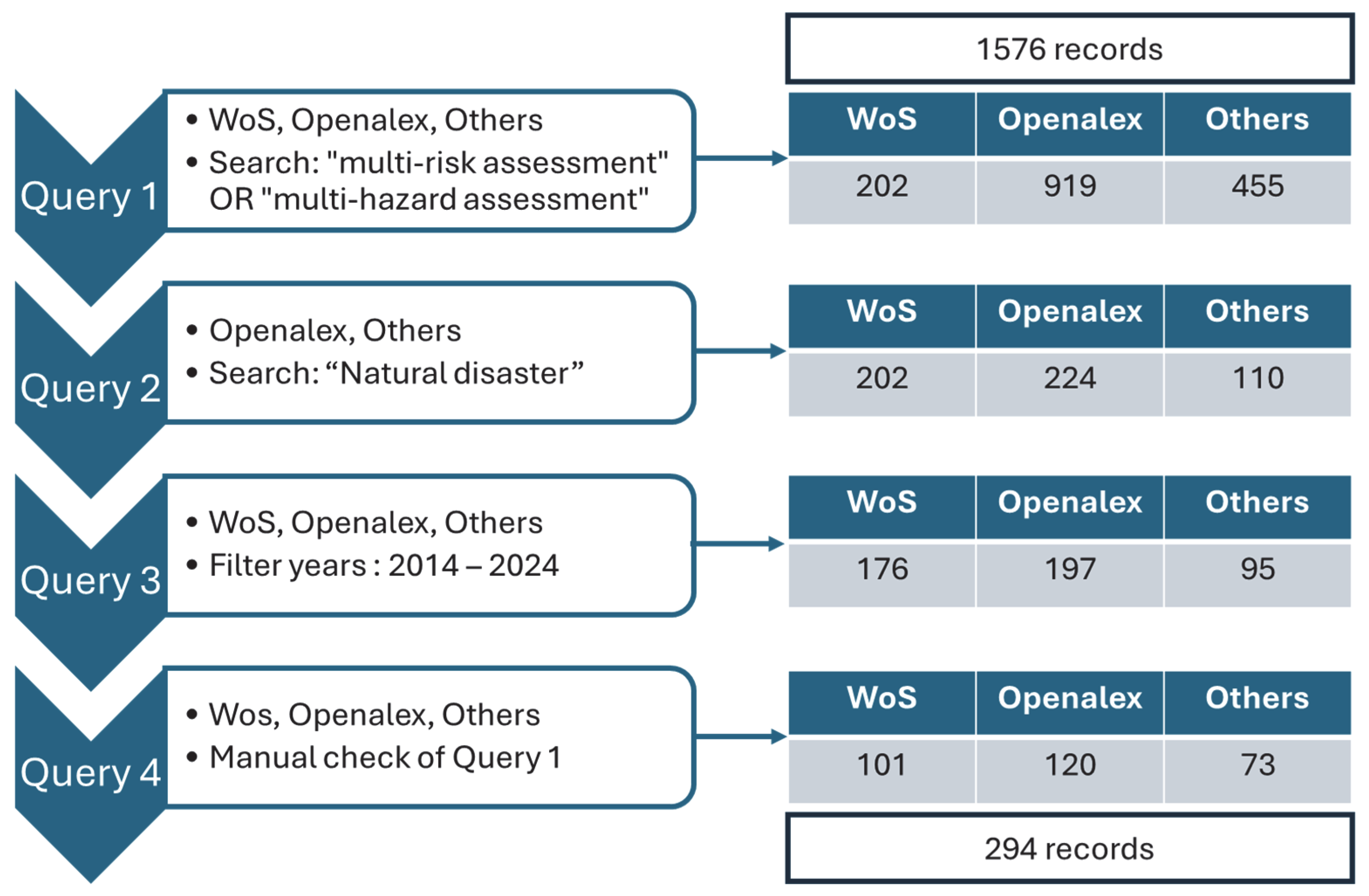
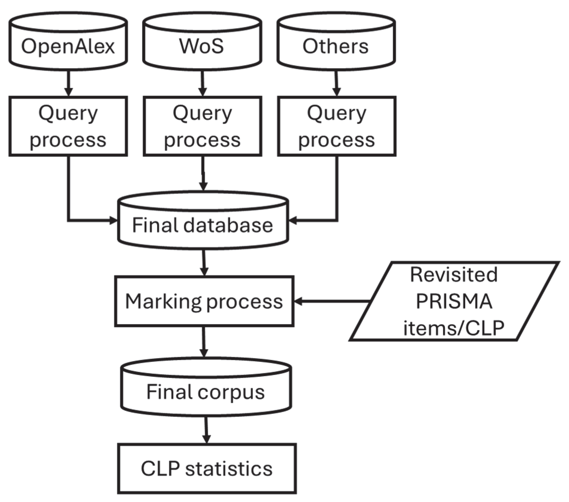
2. Materials and Methods

The review process is based on the selection of scientific publications dealing with the topic of multi-risk assessment for natural disaster prevention, and the analysis of this corpus according to multiple classification criteria.
Potential publications of interest are first extracted from different primary data sources such as “Web of Science”, “OpenAlex”, and a personal list of papers compiled in the last few years over the internet (Others). Each of these sources is harvested by applying the following search expression: (“multi-risk” OR “multi-hazard”) on title and abstract, in order to encompass many academic disseminations. Of course, in this preliminary stage, many results refer to topics far from our interest. This is particularly true for OpenAlex, which is very exhaustive and returns plenty of records dealing with side topics (i.e., health or agriculture sciences) that are too far from our target. A second query on “natural” AND “disaster” is then used to overcome this issue. For focusing our study on the more recent communications, we frame the corpus between the years 2004 and 2025. Finally, the last filtering is conducted manually to check the pertinence of the whole process. Figure 1 presents this search strategy, where a total of 1576 records are initially processed to finally select 294, including 101, 120, and 73 for “Web of Science”, “OpenAlex”, and Others, respectively.
The evaluation step consists of extracting from each of these records diverse levels of information about the conducted multi-risk research. It is inspired by the PRISMA (Preferred Reporting Items for Systematic reviews and Meta-Analyses) method [25], originally developed for reviewing health sciences publications. It proposes to consider a document through 27 items that fully characterize its content and evaluate its pertinence. This method is very interesting since it allows a systematic classification of scientific documentation in a clear and concise process. In our case, we adapt the PRISMA approach to fit with the specificities of our reviewing. In particular, some items or Checklist Points (CLP) were kept (Title, Abstract, Introduction), others were adapted to the theme of multi-risk (Methods, Results), or were ignored (Discussion, Other information) because they were not relevant in the factual analysis. For example, the ten PRISMA CLP originally related to Methods were summarized in three in our approach: Hazards, Aggregation, and Level of aggregation, which gives more clarity to the analysis in our case.
Table 1 presents the five items that were considered in our process, and the six checklist Points (CLP) used to evaluate and classify the 294 selected documents.
The first and second CLP verify that the publication is in line with the perimeter of the review, with clear objectives on multi-hazards or multi-risks assessment. The third CLP is about the hazards or risks addressed in the publication among those identified for the review. This list has been constituted to be representative of the most important natural disasters, including natural-technological (NaTech) or natural-mining ones. The fourth CLP concerns the method proposed to aggregate single to multi-hazards or risks. Again, all listed approaches compile what is most proposed in the scientific literature. The last two CLP are about the scale of the study and the potential transferability from one scale to another.
Figure 2 shows the selection, marking, and analysis processes that led to the final corpus. At the end, each publication is identified as responding favorably or unfavorably to each CLP. A simple count is then carried out to identify the papers meeting each CLP, and the related statistics.

3. Corpus Analysis and Results

A first interesting analysis of the corpus consists of counting the number of references published between 2004 and 2024 (Figure 3). On this figure, we identify an increasing number of multi-hazard and multi-risk papers over the period 2014–2024 that clearly shows a growing interest in these topics by the research community.
This increasing tendency cannot be explained only by the increasing number of reported disasters, since they remain more or less consistent at around 350 since the 2000s [26]. This motivation to undertake research on multi-risk undoubtedly comes from the awareness that followed the Fukushima disaster of 2011 and the observed cascading effects. This awareness of studying disasters in an integrated manner has allowed a large mobilization of researchers on these subjects in the following years.
Let us now analyze the types of publications in our corpus. The selected records are essentially composed of publications in peer-reviewed journals (61%), abstracts of international conferences (20%), review papers (10%), and the last 9% having no bibliometric references. This last set of records, composed essentially of technical reports, unreviewed abstracts, or writings, is discarded from the analysis.
The content of each record is then analyzed according to five categories corresponding to CLP from three to seven as defined in Table 1. The resulting statistical distribution of selected records through these CLP and their related criteria is shown in Figure 4. Note that a paper can refer to several criteria for a specific CLP.
Figure 4 indicates the percentage of publications dealing with the different components of each CLP (Figure 4a–e). For having a clear view of multi-hazard configurations, we counted the occurrence of hazard types studied jointly in Figure 4f. The resulting matrix highlights the geohazard pairs that have been considered in interaction in the multi-risk studies. Let us go deeper into each of these results:
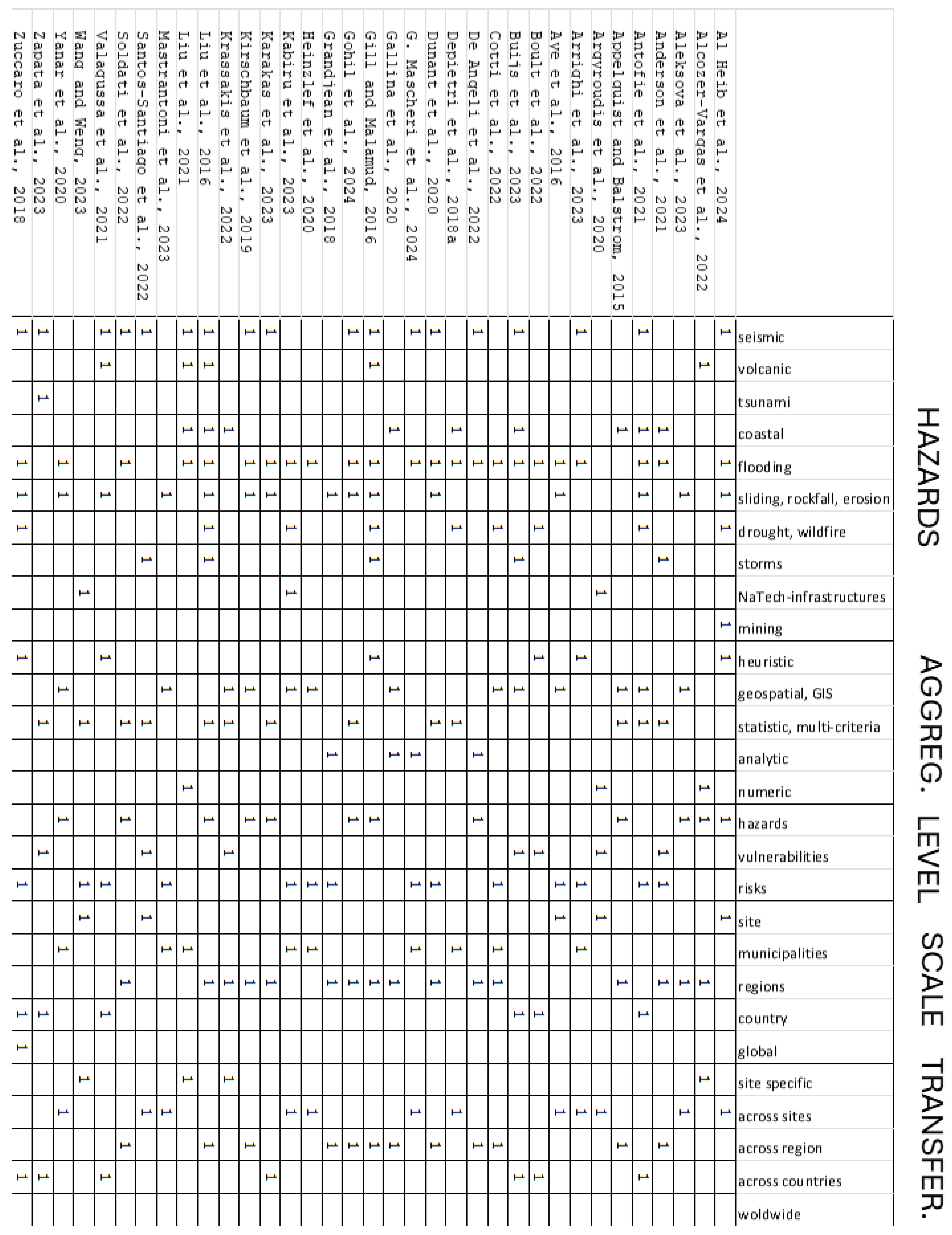
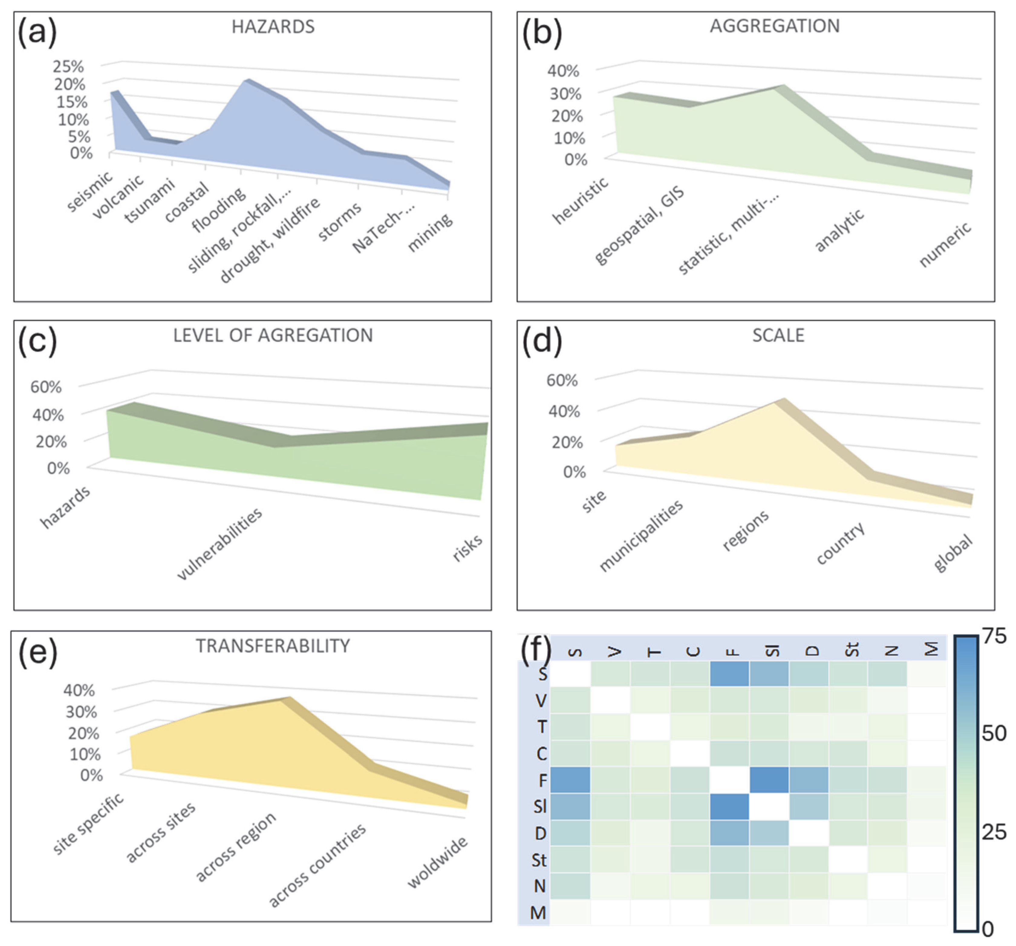
  • HAZARDS (Figure 4a): undoubtedly, natural phenomena due to climate events are the most studied, particularly those related to flooding (more than 20%). Coastal hazards (i.e., coastal submersion and erosion) as well as all landsliding ones (i.e., mudslides, landslides, rockfall, debris-flows, etc.) and droughts/wildfires are also well represented. Then, there come seismic hazards with less interest in the tsunami disasters. Topics less represented in the corpus are NaTech and mining hazards.
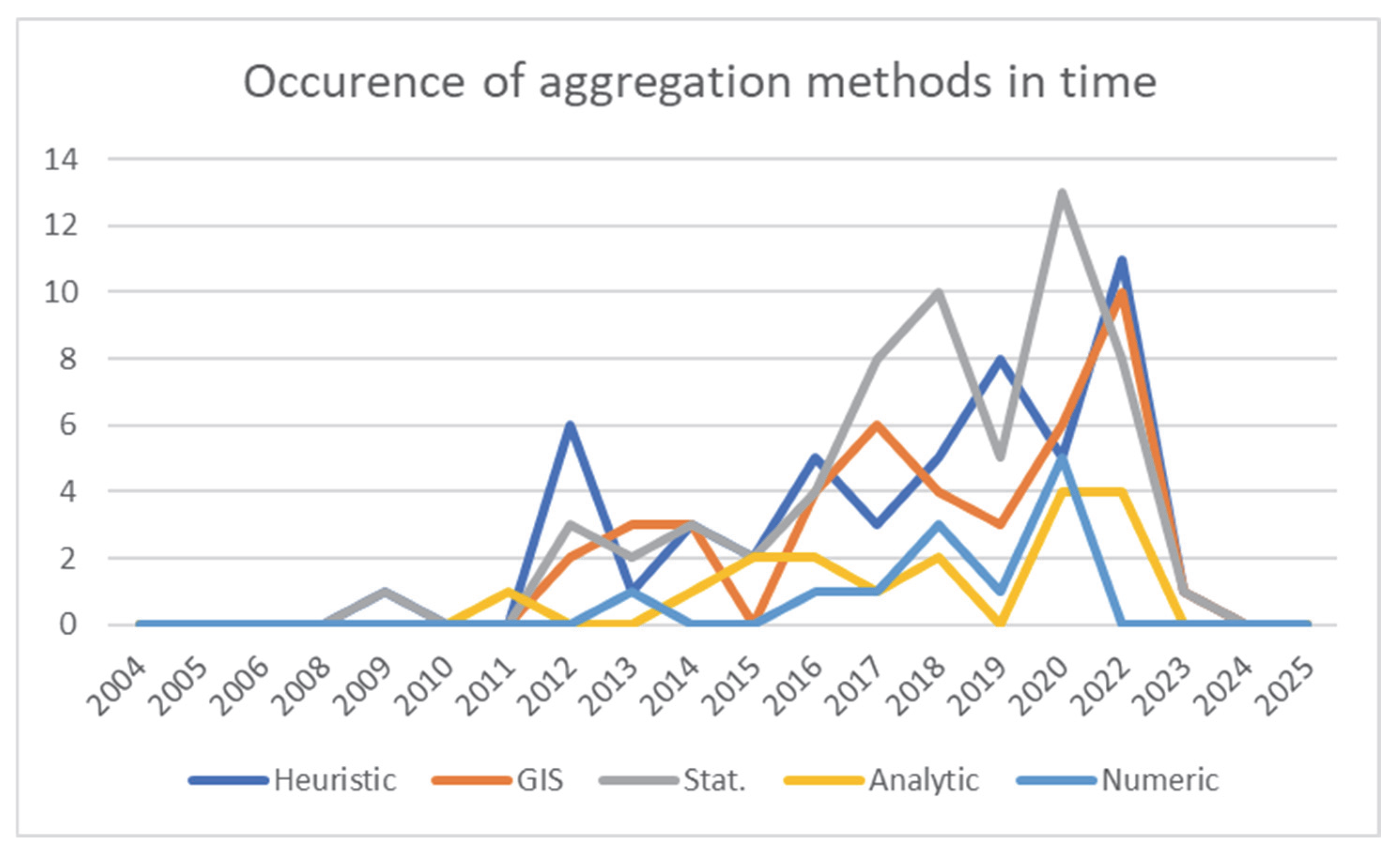
  • AGGREGATION (Figure 4b): Aggregating single-hazard information to obtain a multi-hazard diagnosis is not straightforward. Depending on the quantity and quality of input data, the desired level of uncertainties in the results, the allocated computing resources, etc., the proposed methodologies can vary with the authors’ computing capacities or test site characteristics. Figure 4b shows a quite homogeneous distribution between the different aggregation techniques, even if we can see a higher usage of statistical or GIS approaches (more than 30%) and a lower usage of high computing numerical simulations.
  • LEVEL OF AGGREGATION (Figure 4c): The way of aggregating information at the level of hazards, vulnerabilities, or risks may also depend on the context of the study. Globally, the corpus is quite homogeneous on this question, with less emphasis on multi-vulnerability issues.
  • SCALE (Figure 4d): The spatial scale of study sites also varies greatly, from small objects (house, dam, etc.) or larger spaces (slope, coastline, city, etc.), to national, continental, or global scales. It appears that municipalities or regional scales are the most represented in our corpus (more than 40%)
  • TRANSFERABILITY (Figure 4e): like for the LCP “scale”, most of the studies able to transfer the methodology from one case to another are carried out at the municipality or regional scale (more than 35%)
  • MULTIHAZARDS COMBINATION (Figure 4f): The colored cells shown on this figure are all the bluer as the hazard pairs were found in the corpus. At the top of the list, we have the combinations of floods and landslides (more than 75 cases), then floods and seismic, floods and drought, and finally seismic and landslides. Of course, other combinations are also represented, but to a lesser extent.
In conclusion to this section, we observe a predominance of studies relating to flood and landslide hazards, treated using statistical or GIS techniques, and applied to municipality or regional areas. A more detailed interpretation of these results is given in the discussion section.

4. Discussion

The general remarks formulated from Figure 4 give an overview of the scientific community’s main fields of interest in multi-risk assessment studies in the period 2014–2024. To understand why and how these authors chose to deal with such subjects, we will now go deeper into the content of their articles.

4.1. The Type of Hazard Addressed

Concerning the types of hazards or risks addressed, the growing interest in floods, landslides, coastal, and drought impacts can be explained by their meteorological origin and their increasing occurrence due to climate change. These articles address floods, droughts, storms, and other extreme weather events, keeping in mind that these events can generate several kinds of impacts and risks: ref. [27] conduct a flood and drought risk assessment in the Marrakech–Safi region (Morocco), ref. [28] propose an approach to predicting the impacts of drought in a multi-risk context. In coastal domains, ref. [29] assess the multi-hazard vulnerability of coastal areas to storms and ref. [30] assess flood risks and storms in the Mississippi Delta using a socioecological approach.
Telluric phenomena are also quite present, either because authors are studying active geological contexts like volcanoes [31], or because they are combined with other hazards, depending on the specificities of the studied areas; for example, ref. [32] assess the combined risks of earthquakes and floods at a regional scale, ref. [33] use existing vulnerability models to assess the combined impacts of earthquakes and tsunamis in Peru and ref. [34] optimize building design for earthquakes and extreme winds.
NaTech and mining topics are not so well represented, probably because of the complexity of cascading effects between natural events and technological accidents. However, some authors propose methodological frameworks for assessing the resilience of transport infrastructure to multi-hazards [35,36], with a focus on building vulnerabilities [37].
Finally, some studies propose a more integrative way to analyze multi-risk impacts by defining a conceptual approach for modelling cascading effects and their spatio-temporal description [38,39,40], focusing on areas exposed to climate-related hazards (floods, droughts, landslides), working at the city scale [41], or at the national one [42,43].
This first analysis covers a wide range of natural and technological disasters, with an emphasis on the interactions between risks. In the following, we show how the combined approaches (GIS, artificial intelligence, multi-criteria modelling) are used to assess and anticipate the impacts of such disasters.

4.2. The Methods for Aggregating Information

In terms of aggregation strategies, the effort made on statistical techniques is explained by the democratization of artificial intelligence algorithms that offer efficient methods for processing a large set of data, when available. The growth of remote sensing archives and the possibility to exploit them through web portals is the reason for the success of such approaches. Conversely, using high-performance numerical simulations requires a large level of expertise to manipulate input physical parameters and direct access to adapted computing resources, which explains a lesser use.
During the considered decade, these aggregation methods have not been developed identically. Figure 5 shows the number of occurrences for which each method considered in our analysis has been used between 2004 and 2025 (Figure 6). The general increase of each occurrence in time for all methods can be explained by the increasing number of publications on multi-risk topics shown in Figure 3. Some differences can nevertheless be observed, as follows:
  • Heuristic methods: such methods have been intensively used for decades since they do not require important numerical resources. They are thus easy to implement as soon as local experts have the capabilities to evaluate the importance of risky situations. For example, ref. [44] use a matrix method to weight each of these situations and compile at the end the total level of risk in the context of post-mining risk management. Ref. [45] also uses weighting methods to map erosion and sliding areas with a GIS; ref. [46] propose a weighting wheel to evaluate the impacts of a series of hazards in coastal domains. On the other hand, ref. [47] use a decision tree approach to identify cascading events and evaluate their impacts on exposed assets in the space and time dimensions. Graph methods are also used by ref. [43] to model the interactions and triggering of perils of different types. When exhaustive databases are available, probabilistic indicators [48] or Analytical Hierarchy Process methods [49] are widely used to conduct multi-criteria analyses in multi-risk contexts.
  • GIS and statistical methods: Statistical methods, often coupled with GIS, show the greatest progress in multi-risk assessments in recent years. Undoubtedly, the democratization of artificial intelligence algorithms has made it possible to test new avenues of research exploiting environmental databases [50] and massive Earth observations for decision making [51]. Fuzzy logic is implemented by refs. [39,52,53] or ref. [54] to take into account the uncertainties related to the definition of a hazardous criterion, allowing the quantitative mapping of multiple hazard sources. Refs. [55,56] explore the contribution of artificial intelligence for complex cases of multi-hazards and risk analysis.
  • Analytic approaches are less represented in the corpus, probably because complex and cascading phenomena are more difficult to represent by physical equations. However, ref. [37] formalize hazard occurrences and related impacts by various equations able to elaborate risk scenarios. In the same way, ref. [57] propose to implement mechanistic models in a numerical platform to assess sliding hazards and risks in mountainous areas.
  • Numeric techniques: as already mentioned, numerical methods are used in particular cases where the size of the studied zone and the complexity of physical processes can be numerically integrated into simulation solvers. Ref. [29] demonstrate the usability of such models in the Tokyo Bay to assess multi-hazards due to coastal events. Ref. [58] apply a physically based stability model to map rainfall impacts over mountainous regions.
In summary, the choice of multi-risk assessment methods depends heavily on the available data that feed the model used, the complexity of the study area, and the available human, material, and digital resources. As a consequence, heuristic or GIS methods are well adapted to large and poorly documented areas, whereas numerical methods are more suitable for areas with high exposure and high stakes and where there are sufficient data to calibrate the model. However, the development of machine learning and the availability of environmental data (remote sensing, in situ, social networks, etc.) will surely boost the use of artificial intelligence in multi-risk assessment in the short term [59].

4.3. Level of Assessment, Dimension of Studied Areas, Scale, and Transferability

Multi-risk analysis requires an assessment of multiple vulnerabilities, and therefore, knowledge of the issues exposed, dimensioned at the scale of the study. This problem is already not trivial at local scales, as shown by [60], who consider historical sites. In this case, a classic approach of probabilistic assessment of seismic and flood hazards is carried out, as well as an assessment of the vulnerability of buildings in terms of damage. Joint probabilities extended to the notion of costs then make it possible to evaluate the annual price of risks. Ref. [41] focus on New York City to evaluate the impacts of droughts and floods on socioeconomic activities by using vulnerability indicators appreciated by experts’ knowledge, while ref. [61] use the potential hazard and damage index to assess buildings’ global exposure in Rome, Italy.
More extended domains, such as river basins [62] or mountains [63], are also investigated by GIS techniques applied to remote sensing data, which have the advantage of being able to characterize the evolution of rivers as well as unstable slopes.
National multi-risk assessment is well represented in the corpus, showing the importance for regulators and policymakers to get an overview of possible future disasters [42].
Finally, continental-scale risk assessments are also proposed using GIS to spatially integrate data [64], either for citizens’ security purposes or cultural or natural heritage preservation [65]. In most of these studies, the authors guarantee that the proposed approaches are transferable to other sites. This is not the case for very local scales, where the particularities of the site make the method specific.
Figure 6. List of 35 publications [27,28,29,30,31,32,33,34,35,36,37,38,39,40,41,43,44,45,46,47,48,49,50,51,52,53,54,56,57,60,61,62,63,64,65] selected as representative in addressing the main Checklist Points (CLP) and related items. The “1” value indicates which CLP items are ticked by the publications.
Geohazards 06 00041 g006
The types of disasters taken into account together are earthquakes and floods, revealing a specific attention of research teams to geographical regions exposed to tectonic activities, but also to climatic events such as cyclones. Numerous countries are strongly concerned, such as Japan, Taiwan, India, Indonesia, and the Pacific West Indies islands. In these regions, in addition to volcanic and seismic activity, populations are exposed to intense rainy seasons in the hinterland, aggravated by the sea level rise and storms on the coasts.
One thing that can be noted in the overall corpus of publications is the lack of multidisciplinary approaches mixing multi-hazards assessment and multi-actors risk management. Indeed, too few studies are taking advantage of coupling engineering and social sciences so that stakeholders can be engaged in the processes. In the topic “Understanding disaster risks” of the Sendai framework for disaster risk reduction 2015–2030, it is mentioned “To promote and improve dialogue and cooperation among scientific and technological communities, other relevant stakeholders and policymakers in order to facilitate a science-policy interface for effective decision-making in disaster risk management”. Also promoted by international societies such as the United Nations Disaster Risk Reduction (UNDRR), the participation of policy and decision makers, first responders, and citizens in the development of a new risk management science constitutes a major challenge for the next decades.

5. Conclusions

Because climate change reinforces the frequency and intensity of natural hazards and because socioeconomic contexts make exposed territories more complex, risk management science needs to be evaluated periodically. New efforts were made in the last five years for developing novel multi-risk assessment methodologies that should be integrated in contemporary research and proposed in new mitigation strategies. In this bibliographic overview, an analysis of recent publications on multi-risk assessment methodologies for natural disaster prevention is proposed. Based on different kinds of bibliometric data sources, like Web of Science, OpenAlex, and personal bibliography, a primary selection was applied according to a revised PRISMA method offering an objective methodology for evaluating the content of publications; 294 records were analyzed according to different checklist points (CLP), i.e., criteria referring to multi-risk topics. Statistics were finally computed from this information to evaluate the most addressed CLP.
The analysis highlights an increase in multi-risk studies after 2014, showing the growing concern of the scientific community for complex and multi-factorial risk management. Floods constitute the main concern when coupled with coastal events and landslides. Methodologies for aggregating these natural events use various approaches with a preference for statistical spatialized methods. In general, vulnerability is also considered to assess the impacts on exposed assets. Scale of studied cases varies from the local to the global one, generally with a good level of scalability and transferability to similar situations.
New research trends can be identified and concern particularly the following points: (i) the data used, which are widely oriented toward massive exploitation of remote sensing and spatialized information; (ii) aggregation methodologies or decision-aid procedures that fully exploit artificial intelligence and expert systems; modelling approaches able to simulate complex cascading effects with uncertainties management.
It is also noted that too few studies are integrative and engage stakeholders at a strong level, particularly in the definition, production, and implementation of a new risk science.
These outcomes constitute interesting points of progress in the coming years. Indeed, integrated research on multi-risk management, where new technological and numerical tools are commonly put into services for the benefit of the different stakeholders, constitutes the main challenge to develop new integrated risk research.

Funding

This study has been funded by BRGM and the France 2030 program Risks (IRiMa) under the number ANR-22-EXIR-0002. The total list of the 294 selected publications used in our study is available upon request.

Data Availability Statement

No new data were created or analyzed in this study.

Conflicts of Interest

The authors declare no conflict of interest.

References

  1. Annunziato, A.; Fonio, C.; Proietti, C. Collaboration Between Disaster Managers and Scientists; Publications Office of the European Union: Brussels, Belgium, 2020. [Google Scholar] [CrossRef]
  2. Fuchs, S.; Thaler, T. Tipping Points in Natural Hazard Risk Management: How Societal Transformation can Provoke Policy Strategies in Mitigation. J. Extrem. Events 2017, 4, 1750006. [Google Scholar] [CrossRef]
  3. Schneider, T.; Lochard, J. Supporting societal and economic dynamics of recovery: Lessons from Chernobyl and Fukushima. Ann. ICRP 2021, 50, 68–73. [Google Scholar] [CrossRef]
  4. Curt, C. Multirisk: What trends in recent works?—A bibliometric analysis. Sci. Total Environ. 2021, 763, 142951. [Google Scholar] [CrossRef]
  5. Owolabi, T.A.; Sajjad, M. A global outlook on multi-hazard risk analysis: A systematic and scientometric review. Int. J. Disaster Risk Reduct. 2023, 92, 103727. [Google Scholar] [CrossRef]
  6. Schlumberger, J.; Šakić Trogrlić, R.; Aerts, J.C.J.H.; Hyun, J.-H.; Hochrainer-Stigler, S.; de Ruiter, M.; Haasnoot, M. A Pathways Analysis Dashboard prototype for multi-risk systems. EGUsphere 2024. preprint. [Google Scholar] [CrossRef]
  7. Tilloy, A.; Malamud, B.D.; Winter, H.; Joly-Laugel, A. A review of quantification methodologies for multi-hazard interrelationships. Earth-Sci. Rev. 2019, 196, 102881. [Google Scholar] [CrossRef]
  8. Gallina, V.; Torresan, S.; Critto, A.; Sperotto, A.; Glade, T.; Marcomini, A. A review of multi-risk methodologies for natural hazards: Consequences and challenges for a climate change impact assessment. J. Environ. Manag. 2016, 168, 123–132. [Google Scholar] [CrossRef]
  9. Kappes, M.S.; Keiler, M.; von Elverfeldt, K.; Glade, T. Challenges of analyzing multi-hazard risk: A review. Nat. Hazards 2012, 64, 1925–1958. [Google Scholar] [CrossRef]
  10. Arosio, M.; White, C.; Adnan, M.; Martina, M.; Kennedy, C. A framework for multi-hazard risk indicators. In Proceedings of the EGU General Assembly 2024, Vienna, Austria, 14–19 April 2024. [Google Scholar] [CrossRef]
  11. White, C.J.; Adnan, M.S.G.; Arosio, M.; Buller, S.; Cha, Y.; Ciurean, R.; Crummy, J.M.; Duncan, M.; Gill, J.; Kennedy, C.; et al. Review article: Towards multi-hazard and multi-risk indicators—A review and recommendations for development and implementation. Nat. Hazards Earth Syst. Sci. 2024. preprint. [Google Scholar] [CrossRef]
  12. Corotis, R.; Hammel, E. Multi-attribute aspects for risk assessment of natural hazards. International. J. Risk Assess. Manag. 2010, 14, 437. [Google Scholar] [CrossRef]
  13. Sopery, K.A.M.; Muhammad, N.S.; Abdullah, J.; Bin Mohd, M.S.F.; Desa, S.b.M. Emerging Trends in Flood and Landslide Research: Single Vs Multi-Hazard Disaster Analysis Using GIS. J. Kejuruter. 2022, 34, 999–1015. [Google Scholar] [CrossRef]
  14. Drakes, O.; Tate, E. Social vulnerability in a multi-hazard context: A systematic review. Environ. Res. Lett. 2022, 17, 033001. [Google Scholar] [CrossRef]
  15. Mohammadi, S.; De Angeli, S.; Boni, G.; Pirlone, F.; Cattari, S. Review article: Current approaches and critical issues in multi-risk recovery planning of urban areas exposed to natural hazards. EGUsphere 2023. preprint. [Google Scholar] [CrossRef]
  16. Fekete, A.; Subramanian, S. Multi-risks attributed to climate change and urbanization in East Africa: A bibliometric analysis of a science gap. Afr. Geogr. Rev. 2023, 43, 735–757. [Google Scholar] [CrossRef]
  17. Julia, P.B.; Ferreira, T.M. From single- to multi-hazard vulnerability and risk in Historic Urban Areas: A literature review. Nat. Hazards 2021, 108, 93–128. [Google Scholar] [CrossRef]
  18. Al Hudaib, H.T.; Ray, R.P. The Methodologies and Main Challenges of Assessment the Multi-Hazard Interaction and Risk Management Associated with Roads Infrastructures and Dam Safety: A Review. Int. J. Integr. Eng. 2023, 15, 174–188. [Google Scholar] [CrossRef]
  19. Mesa-Gómez, A.; Casal, J.; Muñoz, F. Risk analysis in Natech events: State of the art. J. Loss Prev. Process Ind. 2020, 64, 104071. [Google Scholar] [CrossRef]
  20. López-Saavedra, M.; Martí, J. Reviewing the multi-hazard concept. Application to volcanic islands. Earth-Sci. Rev. 2022, 236, 104286. [Google Scholar] [CrossRef]
  21. Terzi, S.; Torresan, S.; Schneiderbauer, S.; Critto, A.; Zebisch, M.; Marcomini, A. Multi-risk assessment in mountain regions: A review of modelling approaches for climate change adaptation. J. Environ. Manag. 2018, 232, 759–771. [Google Scholar] [CrossRef]
  22. Kumasaki, M.; King, M.; Arai, M.; Yang, L. Anatomy of cascading natural disasters in Japan: Main modes and linkages. Nat. Hazards 2015, 80, 1425–1441. [Google Scholar] [CrossRef]
  23. Ward, P.; Blauhut, V.; Bloemendaal, N.; Daniell, J.; de Ruiter, M.; Duncan, M.; Emberson, R.; Jenkins, S.; Kirschbaum, D.; Kunz, M.; et al. Review article: Natural hazard risk assessments at the global scale. Nat. Hazards Earth Syst. Sci. 2020, 20, 1069–1096. [Google Scholar] [CrossRef]
  24. Kreibich, H.; Bubeck, P.; Kunz, M.; Mahlke, H.; Parolai, S.; Khazai, B.; Daniell, J.; Lakes, T.; Schroeter, K. A review of multiple natural hazards and risks in Germany. Nat. Hazards 2014, 74, 2279–2304. [Google Scholar] [CrossRef]
  25. Page, M.J.; McKenzie, J.E.; Bossuyt, P.M.; Boutron, I.; Hoffmann, T.C.; Mulrow, C.D.; Shamseer, L.; Tetzlaff, J.M.; Akl, E.A.; Brennan, S.E.; et al. The PRISMA 2020 statement: An updated guideline for reporting systematic reviews. BMJ 2021, 372, n71. [Google Scholar] [CrossRef] [PubMed]
  26. EM-DAT; CRED/UCLouvain. With Major Processing by Our World in Data. “Number of Recorded Natural DISASTER events–EM-DAT” [Dataset]. EM-DAT, CRED/UCLouvain. Natural Disasters 2024, [Original Data]. Retrieved 19 March 2025. Available online: https://ourworldindata.org/grapher/number-of-natural-disaster-events (accessed on 24 June 2025).
  27. Cotti, D.; Harb, M.; Hadri, A.; Aboufirass, M.; Chaham, K.; Libertino, A.; Campo, L.; Trasforini, E.; Krätzschmar, E.; Bellert, F.; et al. An Integrated Multi-Risk Assessment for Floods and Drought in the Marrakech-Safi Region (Morocco). Front. Water 2022, 4, 886648. [Google Scholar] [CrossRef]
  28. Boult, V.L.L.; Black, E.; Abdillahi, H.S.; Bailey, M.; Harris, C.; Kilavi, M.; Kniveton, D.; MacLeod, D.; Mwangi, E.; Otieno, G.; et al. Towards drought impact-based forecasting in a multi-hazard context. Clim. Risk Manag. 2022, 35, 100402. [Google Scholar] [CrossRef]
  29. Liu, F.; Chen, J.; Wang, Y. Numerical Assessment of Coastal Multi-hazard Vulnerability in Tokyo Bay. Res. Sq. 2021, 114, 3597–3625. [Google Scholar] [CrossRef]
  30. Anderson, C.C.; Renaud, F.G.; Hagenlocher, M.; Day, J.W. Assessing Multi-Hazard Vulnerability and Dynamic Coastal Flood Risk in the Mississippi Delta: The Global Delta Risk Index as a Social-Ecological Systems Approach. Water 2021, 13, 577. [Google Scholar] [CrossRef]
  31. Alcozer-Vargas, N.; Reyes-Hardy, M.-P.; Esquivel, A.; Aguilera, F. A GIS-based multi-hazard assessment at the San Pedro volcano, Central Andes, northern Chile. Front. Earth Sci. 2022, 10, 897315. [Google Scholar] [CrossRef]
  32. Soldati, A.; Chiozzi, A.; Nikolić, Ž.; Vaccaro, C.; Benvenuti, E. A PROMETHEE Multiple-Criteria Approach to Combined Seismic and Flood Risk Assessment at the Regional Scale. Appl. Sci. 2022, 12, 1527. [Google Scholar] [CrossRef]
  33. Zapata, J.C.G.; Pittore, M.; Brinckmann, N.; Lizarazo-Marriaga, J.; Medina, S.; Tarque, N.; Cotton, F. Scenario-based multi-risk assessment from existing single-hazard vulnerability models. An application to consecutive earthquakes and tsunamis in Lima, Peru. Nat. Hazards Earth Syst. Sci. 2023, 23, 2203–2228. [Google Scholar] [CrossRef]
  34. Santos-Santiago, M.A.; Ruiz, S.E.; Cruz-Reyes, L. Optimal design of buildings under wind and earthquake, considering cumulative damage. J. Build. Eng. 2022, 56, 104760. [Google Scholar] [CrossRef]
  35. Argyroudis, S.; Mitoulis, S.; Hofer, L.; Zanini, M.; Tubaldi, E.; Frangopol, D. Resilience assessment framework for critical infrastructure in a multi-hazard environment: Case study on transport assets. Sci. Total Environ. 2020, 714, 136854. [Google Scholar] [CrossRef]
  36. Wang, J.; Weng, W. Methodology for Natech coupling risk assessment using correlative multi-criteria decision-making method. J. Loss Prev. Process Ind. 2023, 83, 105060. [Google Scholar] [CrossRef]
  37. Mascheri, G.; Chieffo, N.; Arrighi, C.; Del Gaudio, C.; Lourénço, P. A Framework for Multi-Hazard Assessment in a Historical Area of Lisbon. Int. J. Disaster Risk Reduct. 2024, 108, 104508. [Google Scholar] [CrossRef]
  38. Gill, J.; Malamud, B. Hazard interactions and interaction networks (cascades) within multi-hazard methodologies. Earth Syst. Dyn. 2016, 7, 659–679. [Google Scholar] [CrossRef]
  39. Gallina, V.; Torresan, S.; Zabeo, A.; Critto, A.; Glade, T.; Marcomini, A. A Multi-Risk Methodology for the Assessment of Climate Change Impacts in Coastal Zones. Sustainability 2020, 12, 3697. [Google Scholar] [CrossRef]
  40. De Angeli, S.; Malamud, B.; Rossi, L.; Taylor, F.; Trasforini, E.; Rudari, R. A multi-hazard framework for spatial-temporal impact analysis. Int. J. Disaster Risk Reduct. 2022, 73, 102829. [Google Scholar] [CrossRef]
  41. Depietri, Y.; Dahal, K.; McPhearson, T. Multi-hazard risks in New York City. Nat. Hazards Earth Syst. Sci. 2018, 18, 3363–3381. [Google Scholar] [CrossRef]
  42. Thompson, H.E.; Gill, J.C.; Šakić Trogrlić, R.; Taylor, F.E.; Malamud, B.D. A methodology to compile multi-hazard interrelationships in a data-scarce setting: An application to the Kathmandu Valley, Nepal. Nat. Hazards Earth Syst. Sci. 2025, 25, 353–381. [Google Scholar] [CrossRef]
  43. Dunant, A.; Bebbington, M.; Davies, T. Probabilistic cascading multi-hazard risk assessment methodology using graph theory, a New Zealand trial. International. J. Disaster Risk Reduct. 2020, 54, 102018. [Google Scholar] [CrossRef]
  44. Al Heib, M.; Franck, C.; Djizanne, H.; Degas, M. Post-Mining Multi-Hazard Assessment for Sustainable Development. Sustainability 2024, 15, 8139. [Google Scholar] [CrossRef]
  45. Aleksova, B.; Lukic, T.; Milevski, I.; Spalevic, V.; Markovic, S.B. Modelling Water Erosion and Mass Movements (Wet) by Using GIS-Based Multi-Hazard Susceptibility Assessment Approaches: A Case Study-Kratovska Reka Catchment (North Macedonia). Atmosphere 2023, 14, 1139. [Google Scholar] [CrossRef]
  46. Appelquist, L.R.; Balstrom, T. Application of a new methodology for coastal multi-hazard-assessment & management on the state of Karnataka, India. J. Environ. Manag. 2015, 152, 1–10. [Google Scholar] [CrossRef]
  47. Zuccaro, G.; De Gregorio, D.; Leone, M. Theoretical model for cascading effects analyses. Int. J. Disaster Risk Reduct. 2018, 30, 199–215. [Google Scholar] [CrossRef]
  48. Liu, B.; Siu, Y.L.; Mitchell, G. Hazard interaction analysis for multi-hazard risk assessment: A systematic classification based on hazard-forming environment. Nat. Hazards Earth Syst. Sci. 2016, 16, 629–642. [Google Scholar] [CrossRef]
  49. Krassakis, P.; Karavias, A.; Nomikou, P.; Karantzalos, K.; Koukouzas, N.; Athinelis, I.; Kazana, S.; Parcharidis, I. Multi-Hazard Susceptibility Assessment Using the Analytical Hierarchy Process in Coastal Regions of South Aegean Volcanic Arc Islands. Geohazards 2023, 4, 77–106. [Google Scholar] [CrossRef]
  50. Antofie, T.-E.; Stefano, L.; Marin-Ferrer, M.; Patrascu, F.; Eklund, G.; Lindl, F.; Santini, M.; Brian, D. Identifying multi-hazard potential impact at the pan-European level: The DRMKC Risk Data Hub methodology. In Proceedings of the EGU General Assembly 2021, Online, 19–30 April 2021. [Google Scholar] [CrossRef]
  51. Heinzlef, C.; Becue, V.; Serre, D. A spatial decision support system for enhancing resilience to floods: Bridging resilience modelling and geovisualization techniques. Nat. Hazards Earth Syst. Sci. 2020, 20, 1049–1068. [Google Scholar] [CrossRef]
  52. Gohil, M.; Mehta, D.; Shaikh, M. An integration of geospatial and fuzzy-logic techniques for multi-hazard mapping. Results Eng. 2024, 21, 101758. [Google Scholar] [CrossRef]
  53. Karakas, G.; Kocaman, S.; Gokceoglu, C. A Hybrid Multi-Hazard Susceptibility Assessment Model for a Basin in Elazig Province, Turkiye. Int. J. Disaster Risk Sci. 2023, 14, 326–341. [Google Scholar] [CrossRef]
  54. Yanar, T.; Kocaman, S.; Gökçeoğlu, C. Use of Mamdani Fuzzy Algorithm for Multi-Hazard Susceptibility Assessment in a Developing Urban Settlement (Mamak, Ankara, Turkey). ISPRS Int. J. Geo-Inf. 2020, 9, 114. [Google Scholar] [CrossRef]
  55. Guikema, S. Artificial Intelligence for Natural Hazards Risk Analysis: Potential, Challenges, and Research Needs. Risk Anal. 2020, 40, 1117–1123. [Google Scholar] [CrossRef] [PubMed]
  56. Kabiru, P.; Kuffer, M.; Sliuzas, R.V.; Vanhuysse, S. The relationship between multiple hazards and deprivation using open geospatial data and machine learning. Nat. Hazards 2023, 119, 907–941. [Google Scholar] [CrossRef]
  57. Grandjean, G.; Thomas, L.; Bernardie, S.; The SAMCO Team. A Novel Multi-Risk Assessment Web-Tool for Evaluating Future Impacts of Global Change in Mountainous Areas. Climate 2018, 6, 92. [Google Scholar] [CrossRef]
  58. Chen, H.; Zhang, S.; Peng, M.; Zhang, L. A physically-based multi-hazard risk assessment platform for regional rainfall-induced slope failures and debris flows. Eng. Geol. 2015, 203, 15–29. [Google Scholar] [CrossRef]
  59. Nguyen, H.D.; Dang, D.-K.; Bui, Q.-T.; Petrisor, A.-I. Multi-hazard assessment using machine learning and remote sensing in the North Central region of Vietnam. Trans. GIS 2023, 27, 1614–1640. [Google Scholar] [CrossRef]
  60. Arrighi, C.; Tanganelli, M.; Cristofaro, M.T.; Cardinali, V.; Marra, A.; Castelli, F.; De Stefano, M. Multi-risk assessment in a historical city. Nat. Hazards 2023, 119, 1041–1072. [Google Scholar] [CrossRef]
  61. Mastrantoni, G.; Masciulli, C.; Marini, R.; Esposito, C.; Mugnozza, G.; Mazzanti, P. A novel model for multi-risk ranking of buildings at city level based on open data: The test site of Rome, Italy. Geomat. Nat. Hazards Risk 2023, 14, 1. [Google Scholar] [CrossRef]
  62. Aye, Z.C.; Jaboyedoff, M.; Derron, M.H.; van Westen, C.J.; Hussin, H.Y.; Ciurean, R.L.; Frigerio, S.; Pasuto, A. An interactive web-GIS tool for risk analysis: A case study in the Fella River basin, Italy. Nat. Hazards Earth Syst. Sci. 2016, 16, 85–101. [Google Scholar] [CrossRef]
  63. Kirschbaum, D.; Watson, C.S.; Rounce, D.R.; Shugar, D.H.; Kargel, J.S.; Haritashya, U.K.; Amatya, P.; Shean, D.; Anderson, E.R.; Jo, M. The State of Remote Sensing Capabilities of Cascading Hazards Over High Mountain Asia. Front. Earth Sci. 2019, 7, 197. [Google Scholar] [CrossRef] [PubMed]
  64. Buijs, S.; de Ruiter, M.; Ward, P. A continental-scale multi-hazard analysis of economic recovery using nighttime light satellite data. In Proceedings of the EGU General Assembly 2023, Vienna, Austria, 24–28 April 2023. [Google Scholar] [CrossRef]
  65. Valagussa, A.; Frattini, P.; Crosta, G.; Spizzichino, D.; Leoni, G.; Margottini, C. Multi-risk analysis on European cultural and natural UNESCO heritage sites. Nat. Hazards 2021, 105, 2659–2676. [Google Scholar] [CrossRef]
Figure 1. Query process applied to the three primary sources: “Web of Science” (WoS), “OpenAlex”, and a personal bibliography (Others).
Geohazards 06 00041 g001
Figure 2. General process applied to the original databases to obtain a final corpus marked with revisited PRISMA items/Checklist Points (CLP) and CLP statistics.
Geohazards 06 00041 g002
Figure 3. Distribution showing the number of references published between 2004 and 2025 in the corpus.
Geohazards 06 00041 g003
Figure 4. (ae): Statistic distribution of the analyzed records according to the five identified CLP; (f): multi-hazard combinations; max values in blue indicate high occurrence of coupling between two hazards (S = seismic, V = volcanic, T = tsunami, C = coastal, F = Flood, Sl = Sliding, D = drought and wildfire, St = storms, N = NaTech and infrastructures, M = mining).
Geohazards 06 00041 g004
Figure 5. The occurrence of aggregation methods between 2004 and 2025.
Geohazards 06 00041 g005
Table 1. Items and Checklist Points (CLP) used in the evaluation of the corpus.
ItemChecklist Points (CLP)
1—Title and abstract1—Is about multi-risks, multi-hazards, natural disaster
2—Introduction2—Presents rationale and clear objectives
3—Material and method3—HAZARDS: addresses several kinds of hazards and/or risks among Seismic, Volcanic, Tsunami, Coastal, Flooding, Landsliding (incl. rockfall, erosion), Wildfire, Storms, NaTech and Mining.
4—AGGREGATION: proposes a method for aggregating several hazards and/or risks: Heuristic, Geospatial and GIS, Statistic and multi-criteria, Analytic, Numeric.
5—LEVEL OF AGGREGATION: shows if the study focuses on multi-hazards, multi-vulnerabilities or multi-risks, depending on the fusion of information is on Hazards, Vulnerabilities or Risks.
4—Results6—SCALE: tests the method on a specific scale: Sites, Municipalities, Regions, Countries and Global.
5—Discussion7—TRANSFERABILITY: discusses about the transferability of the method to other scales: Site specific, scalable across Sites, Regions, Countries.
Disclaimer/Publisher’s Note: The statements, opinions and data contained in all publications are solely those of the individual author(s) and contributor(s) and not of MDPI and/or the editor(s). MDPI and/or the editor(s) disclaim responsibility for any injury to people or property resulting from any ideas, methods, instructions or products referred to in the content.

