Article

A Multi-Temporal Knowledge Graph Framework for Landslide Monitoring and Hazard Assessment

1
Wuhan Center of Geological Survey, China Geological Survey, Wuhan 430205, China
2
Key Laboratory of Operation Safety of High Dam and Large Reservoir, China Three Gorges Corporation, Yichang 443133, China
3
School of Earth Resources, China University of Geosciences, Wuhan 430074, China
4
Qinghai Bureau of Environmental Geology Exploration, Xining 810001, China
5
School of Computer Sciences, China University of Geosciences, Wuhan 430074, China
6
School of Information Engineering, Xinjiang Institute of Technology, Akesu 843100, China
*
Author to whom correspondence should be addressed.
GeoHazards 2025, 6(3), 39; https://doi.org/10.3390/geohazards6030039
Submission received: 27 May 2025 / Revised: 9 July 2025 / Accepted: 17 July 2025 / Published: 23 July 2025
(This article belongs to the Special Issue Landslide Research: State of the Art and Innovations)

Abstract

In the landslide chain from pre-disaster conditions to landslide mitigation and recovery, time is an important factor in understanding the geological hazards process and managing landsides. Static knowledge graphs are unable to capture the temporal dynamics of landslide events. To address this limitation, we propose a systematic framework for constructing a multi-temporal knowledge graph of landslides that integrates multi-source temporal data, enabling the dynamic tracking of landslide processes. Our approach comprises three key steps. First, we summarize domain knowledge and develop a temporal ontology model based on the disaster chain management system. Second, we map heterogeneous datasets (both tabular and textual data) into triples/quadruples and represent them based on the RDF (Resource Description Framework) and quadruple approaches. Finally, we validate the utility of multi-temporal knowledge graphs through multidimensional queries and develop a web interface that allows users to input landslide names to retrieve location and time-axis information. A case study of the Zhangjiawan landslide in the Three Gorges Reservoir Area demonstrates the multi-temporal knowledge graph’s capability to track temporal updates effectively. The query results show that multi-temporal knowledge graphs effectively support multi-temporal queries. This study advances landslide research by combining static knowledge representation with the dynamic evolution of landslides, laying the foundation for hazard forecasting and intelligent early-warning systems.

1. Introduction

With the advancement of big data and artificial intelligence, landslide research previously evolved from traditional model-driven paradigms to data-driven ones, but it is now transitioning towards knowledge-guided paradigms [1,2,3,4]. Knowledge graphs (KGs) are graph structures that represent entities and their semantic relationships through triplets (subject–predicate–object). They integrate heterogeneous multi-source data to structure complex domain knowledge. By extracting potential knowledge, the knowledge graph provides specific knowledge services including knowledge retrieval, knowledge reasoning, and knowledge recommendation [5]. In landslide research, KGs integrate multi-source data to reveal the potential factors and patterns of landslide occurrence, assisting experts in risk assessment, prediction model construction, and decision support [1,4].
Currently, research on landslide KGs mainly focuses on two aspects: the construction of landslide KGs and the application of landslide KGs. The construction process includes two interdependent layers—the schema layer and the data layer [3,6]. The design of the schema layer requires a clear definition of entities within the landslide domain, such as landslide types, triggering factors, and geographic entities. It also defines their semantic relationships to ensure that the KG accurately represents the knowledge structure and underlying mechanisms of the landslide domain [4,7]. Meanwhile, the data layer focuses on annotating and extracting multi-source geographic and spatial information from geological surveys, remote sensing imagery, meteorological records, and more. After data cleaning and standardization, heterogeneous datasets are integrated to build a unified KG. This process involves the mapping of structured data, known as entity recognition, and relation extraction [8,9,10].
In the construction of the instance layer, knowledge extraction technology initially employed rule-based methods, which are advantageous in quickly identifying entities with high accuracy and strong interpretability. However, they suffer from high maintenance costs and a weak generalization ability [11]. Subsequently, statistical machine learning methods, such as HMM, CRF, and SVM, enhance the flexibility and generalization ability of models. Nevertheless, they require a large amount of labeled data for obtaining high performance in knowledge extraction [12]. The rapid development of deep learning technology is marked by word embedding, sequence models, and pre-trained language models, and has greatly enhanced feature learning and semantic understanding capabilities, improving the efficiency of multi-source data processing and the generalization process. However, training requires a massive amount of labeled data and consumes a significant amount of computing resources [13,14,15,16]. Recently, technologies based on large language models, such as prompt engineering, are convenient to use and can quickly adapt to different tasks and fields; however, these also face challenges such as high requirements for model size and quality, possible biases or errors, and insufficient stability when dealing with complex logic and high-precision tasks in specific fields [17].
The application of landslide KGs generally includes question-answering systems, recommendation systems, and knowledge discovery. Reference [18] achieves personalized recommendations of landslide disaster scene data through the KG. References [19,20] utilize logic-based reasoning to infer potential landslide risks and key triggering mechanisms, thereby supporting predictive models and early warning systems. Reference [21] employs graph analysis methods to identify potential associations between landslide occurrences and environmental factors, such as climate characteristics and seismic activity. Knowledge graphs are utilized to identify feature factors of landslides in different regions, followed by machine learning-based landslide susceptibility assessments.
However, existing landslide KGs remain predominantly static, lacking temporal dynamic representation [22,23]. This poses significant constraints, particularly when considering the inherent temporal dynamics of landslides. Landslides manifest distinct temporal evolution patterns, with the deformation process progressing through the initial phase, the constant rate phase, and the acceleration phase. In terms of space, surface cracks transform from discrete entities into interconnected networks, and these spatial alterations are intrinsically intertwined with the temporal progression of the landslides [24]. Moreover, path dependency theory highlights the importance of historical development in landslide outcomes [25]. Static KGs are unable to capture dynamic landslide evolution data, compromising their utility in complex forecasting, real-time alerting, and adaptive mitigation.
Currently, the defects in dynamic data capture and the temporal dimension representation of existing landslide knowledge graphs severely restrict their application in landslide monitoring and early warning [22,23,24,25]. To address these gaps, this paper proposes a multi-temporal knowledge graph (MTKG) of landslides capable of tracking temporal evolution and integrating dynamic data. The proposed framework enables the version control of deformation phases and event sequences, ensuring the representation of landslide historical information. We develop a systematic workflow and demonstrate its feasibility through case studies. This workflow encompasses temporal ontology design, temporal knowledge representation, KG querying, and the development of query web interfaces.

2. Materials and Methods

2.1. Dataset

The Three Gorges Reservoir Area, located at the junction of Hubei Province and Chongqing City in the upper reaches of the Yangtze River, frequently experiences landslides, resulting in significant safety risks and economic losses [26,27,28,29]. During the data collection and organization phase, the Three Gorges Reservoir Area landslides were used as the research object. Triples were constructed based on the landslide disaster domain ontology model defined by experts. The research data primarily consist of tabular data (such as historical disaster survey details of the Three Gorges, disaster risk data details, etc.) and plain text data (such as governance project investigation reports, emergency reports, etc.). Once the tabular data were standardized, they was mapped into triples. Triples are extracted from plain text data through manual annotation.

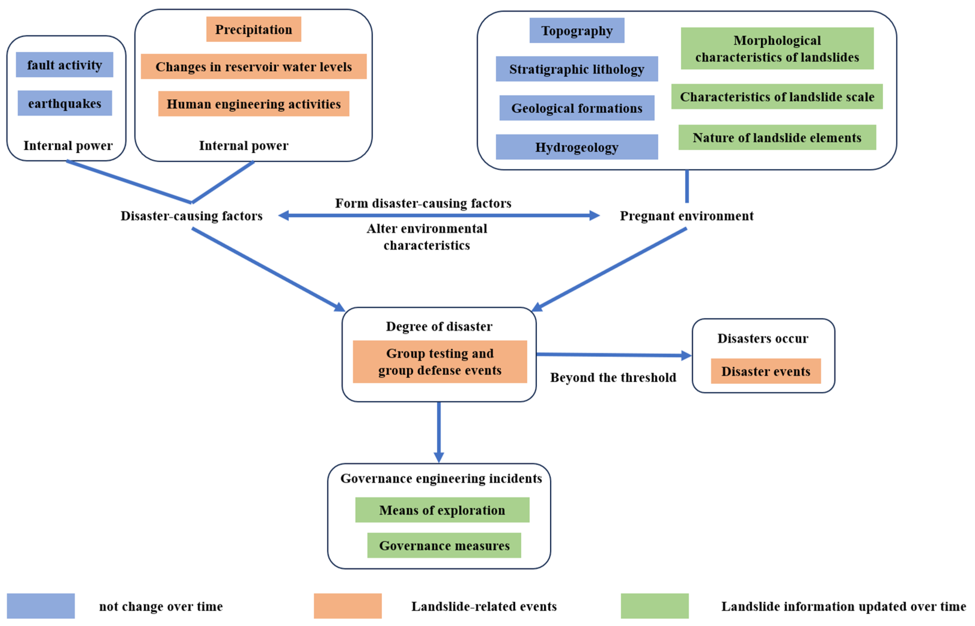
2.2. Temporal Ontology for Landslide
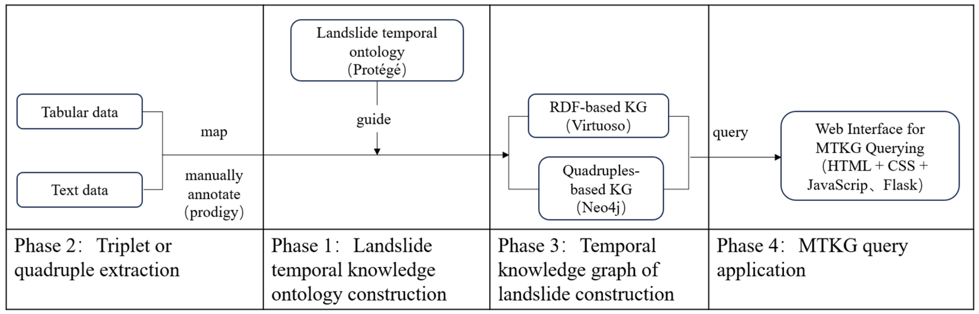
The ontology defines key concepts, entities, and relationships in the landslide disaster domain, forming a basic knowledge-representation framework. The temporal KG then adds a time dimension to capture dynamic changes, allowing it to reflect the landslide event evolution. Finally, landslide temporal knowledge is used to analyze multi-temporal data, revealing temporal features and patterns and supporting monitoring, early warning, and mitigation.
Ontology, originally rooted in philosophical studies of existence, has been widely used to formalize domain knowledge. In the construction of KGs, it plays an important role at the schema layer, ensuring data consistency and interoperability through hierarchical classification and logical constraints [5]. Its basic components include classes, instances, attributes, and relationships. Classes define categories of things. In the field of computer science, ontology helps construct standardized models that assist domains such as geology in achieving precise data interoperability, knowledge sharing, and intelligent reasoning, thereby supporting accurate analysis, decision-making, and automated diagnosis tasks [6,30].
Traditional KGs store objective facts in the form of triples but lack time-related information. With the growing focus on temporal data, researchers have extended traditional KGs by incorporating temporal information, resulting in temporal KGs. By introducing time as an explicit dimension, temporal KGs expand traditional static graphs and capture the evolution of entities and relationships over discrete or continuous time intervals. This is achieved by encoding time attributes (such as timestamps or time intervals) into triples, forming quadruples (subject–predicate–object–time) [31], which represent state changes, event sequences, or versioned information. In fields such as geology [32], temporal data are crucial for the understanding and reasoning of knowledge.
In this study, the MTKG of the landslide addresses the temporal dynamics of the landslide process by integrating the versioned updates of landslide attributes and the temporal sequences of landslide-related events. This integration enables the continuous tracking of landslide progression and triggering factors through time. By contextualizing events (e.g., rainfall episodes, mitigation actions) with their geological framework and timestamps, the framework systematically incorporates temporal information into applications such as risk forecasting and adaptive mitigation strategies.
Landslide evolution is a complex, nonlinear dynamic process that unfolds over time and space [33]. The occurrence of landslides is typically the result of the combined influence of external natural factors (e.g., rainfall, earthquakes, reservoir water levels, etc.) and anthropogenic factors (e.g., mining, construction, road building, etc.) [34]. Time not only affects the triggering conditions and environmental factors of landslides, but also determines their scale and the extent and severity of damage [35]. The dynamic of landslide knowledge can be conceptualized through two aspects: the versioned updates of landslide attributes and the temporal sequences of landslide-related events.
As exploration technologies advance and landslide information evolves, it is continuously updated. Data collected at different time points reflect the current observation and understanding of the landslides. For instance, the crest elevation of the Zhangjiawan landslide was recorded as 210 m on 18 March 2008, and was further updated to 260 m on 28 October 2021, reflecting the natural evolution of the landslide. Similarly, the geological age of the sliding surface was initially updated to the Lower Jurassic Xiangxi Formation on 18 March 2008 and was later revised to include the Middle Triassic Badong Formation on the same day, due to advancements in exploration technology. These versioned updates are critical for understanding the path-dependent nature of landslide evolution [25], where early geological conditions and external factors significantly influence future landslide behavior.
Landslide-related events refer to a series of phenomena associated with landslides that occur at specific times and locations, shaped by multiple interacting factors. Each event has distinct temporal, spatial, and influencing factors, which may include topography, geological conditions, climatic variations, and human activities. For example, community-based monitoring events involve local residents documenting the deformation characteristics of rock and soil masses, fissures, and their occurrence times. These events reflect the dynamic process of landslide evolution, being essential for hazard assessments, early warnings, and emergency responses.

2.3. Workflow

To construct the Landslide MTKG, we define a workflow in four phases: ontology construction, MTKG construction, knowledge graph query validation, and web interface for querying. The workflow diagram of this study is shown in Figure 1.
When constructing the Landslide MTKG, the first step is to organize domain knowledge related to landslides, especially knowledge involving temporal attributes. We compiled a dataset that includes semi-structured and unstructured data, integrating knowledge related to temporal attributes. Next, based on the features of the dataset and its related entities and semantic relationships, a hierarchical KG was constructed. In this process, semi-structured data were converted into triples and quadruples, extracting structured information related to time from unstructured texts. These triples and quadruples were stored in an RDF format in a Virtuoso database. For quadruples containing temporal information, they were further converted into triples with temporal attributes and stored in a Neo4j database. SPARQL and Cypher queries were then used to validate the operability of the RDF-based KG and to verify the usability of the quadruple-based KG, respectively. Finally, a web interface was integrated, allowing users to query relevant coordinates, timelines, and the latest developments of landslide-related events.
Through the above steps, a Landslide MTKG containing landslide domain knowledge was successfully constructed. This graph not only effectively stores and manages semi-structured and unstructured data related to landslides but also provides flexible querying capabilities, meeting the user’s need for real-time information on landslide-related events. With RDF storage and quadruple processing, the graph can accurately reflect the temporal attributes and sequential progression of events, enhancing the understanding of landslide-related events in terms of time series. Additionally, the integration of the web interface has made querying and displaying the graph more convenient, greatly improving the user experience. Users can easily query and visualize various data related to landslide-related events, further enhancing the efficiency and accuracy of information retrieval.

3. Results

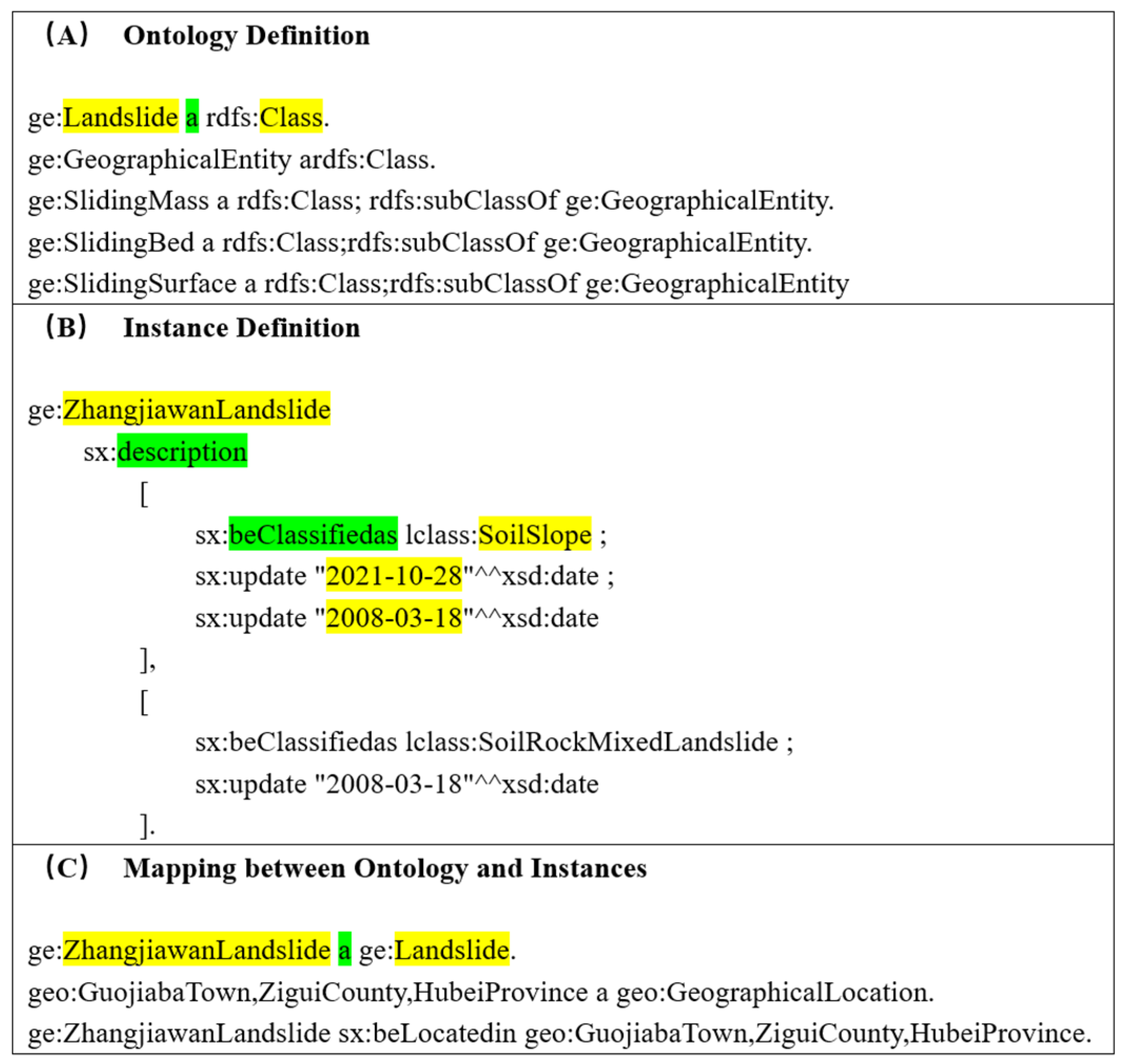
3.1. Landslide Temporal Ontology Model

In the process of constructing the landslide geological disaster domain ontology model, it is crucial to organize and thoroughly comprehend the relevant knowledge system in a systematic manner. Table 1 summarizes the key knowledge within the landslide domain based on the characteristics of the landslide data in the Three Gorges Reservoir Area. This knowledge serves as the base of ontology construction.
In the process of ontology construction, a use-case-driven approach combining the top-down and bottom-up approaches was used to design the ontology. In the top-down stage, experts systematically reviewed classical theories and expert knowledge in the field of landslides from two perspectives: the landslide disaster system and landslide temporal knowledge. Among them, the landslide disaster system systematically classified the influencing factors of landslides, such as geological structures, meteorological conditions, and human activities, as well as their hierarchical relationships through a class hierarchy, while the landslide temporal knowledge introduced temporal attributes and dynamic relationships, embedding the entire life cycle of landslides as a time series into the ontology, including induction, occurrence, development, and governance. In the bottom-up stage, according to the needs of knowledge graph applications, experts enumerated entity types based on the actual characteristics of landslide data in the Three Gorges Reservoir Area based on the geoscience literature and then organized and supplemented the details of the ontology through inductive analyses based on the theories formed in the top-down stage.
Upon the systematic organization of the knowledge framework, it becomes imperative to establish connections between the various components through the application of the disaster chain management system. The induction environment encompasses fundamental conditions, such as geological structure, topography, and hydrogeology. These factors collectively contribute to landslide predisposition. Triggering factors include intense or prolonged rainfall and anthropogenic activities (e.g., slope cutting, road construction, and mining), which directly initiate landslides by destabilizing the soil–rock equilibrium. Landslides arise from the interplay between the induction environment and triggering factors. Mitigation strategies involve implementing engineering interventions, such as anti-sliding piles, retaining walls, drainage systems, and slope reduction measures, to mitigate risks and control the progression of landslides. As shown in Figure 2, this figure comprehensively demonstrates the relationships among the disaster induction environment, triggering factors, disaster occurrence, and mitigation measures, detailing the interactions of various elements [36].

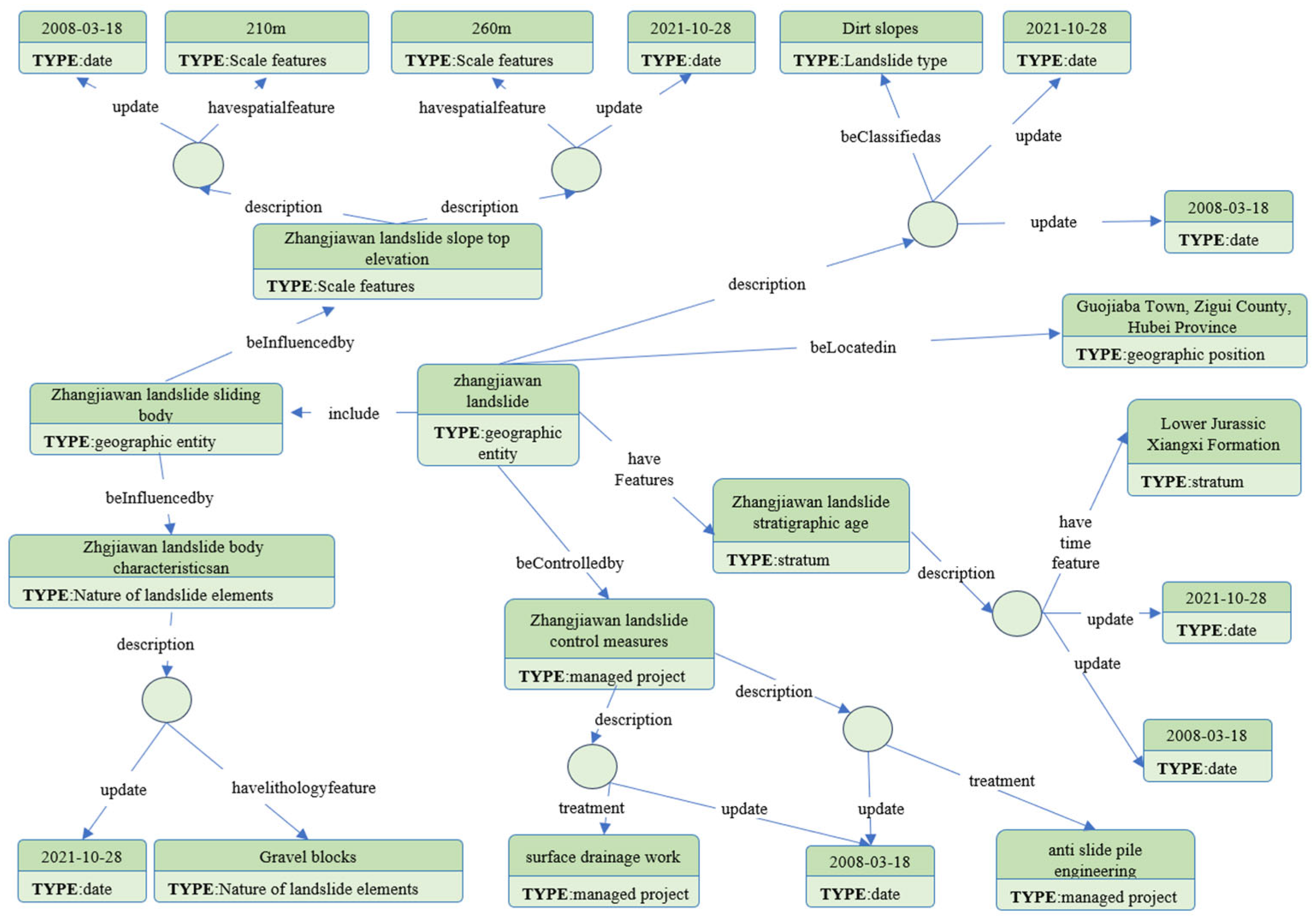
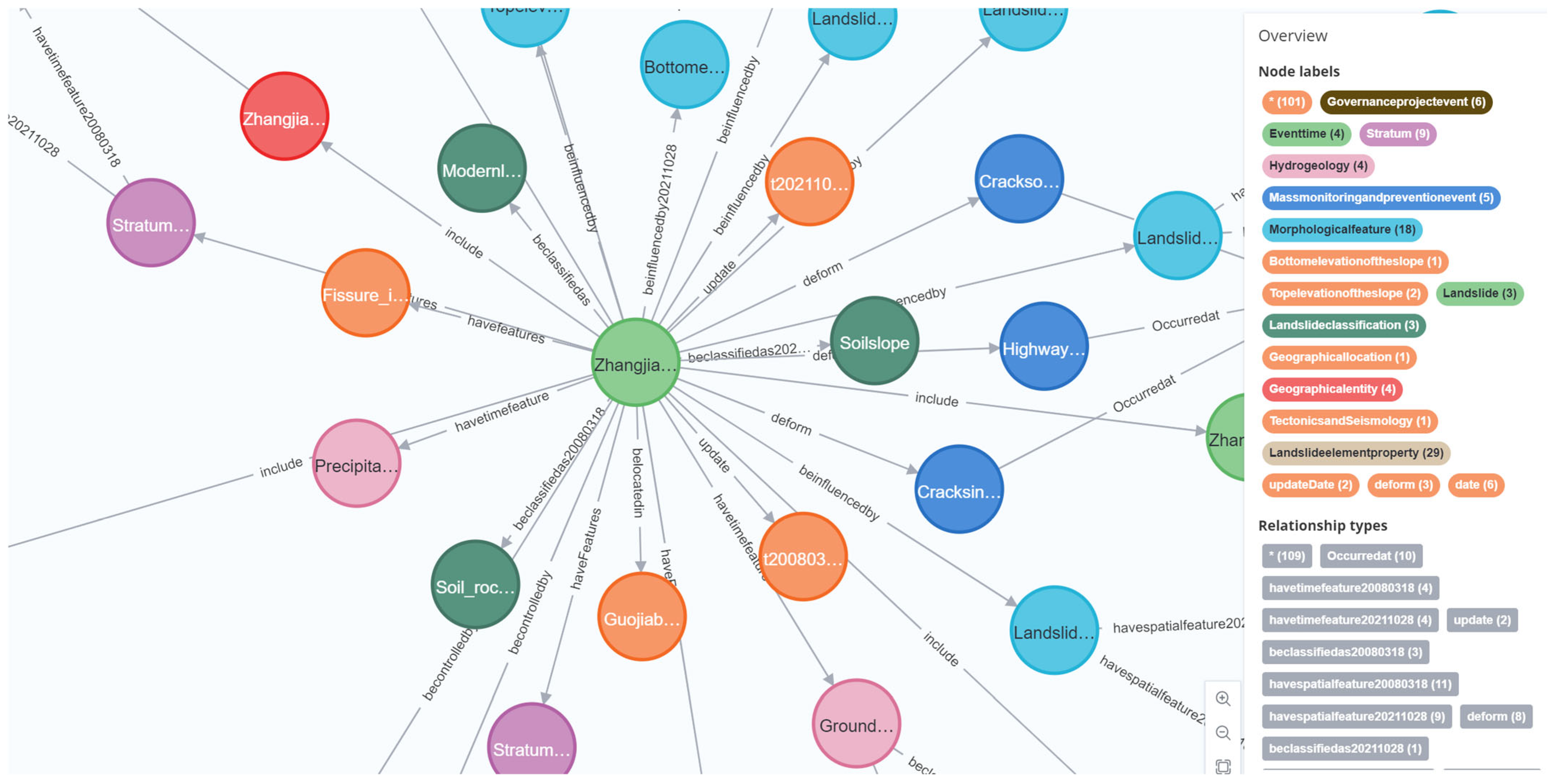
3.2. Temporal Knowledge Graph of Landslide

3.2.1. RDF-Based Construction of Temporal Knowledge Graph

The RDF serves as a standardized framework for representing data in the form of a directed graph, consisting of triples (subject–predicate–object) [19]. A key step in constructing the ontology framework is defining hierarchical classes. In detail, the primary label is designated as a superclass (e.g., GeographicalEntity), and its associated secondary labels (e.g., Landslide, SlidingBody, SlidingBed, SlidingSurface, SlidingZoneSoil, ControllingStructuralPlane) are structured as subclasses. This hierarchical classification ensures semantic clarity and facilitates reasoning across geological entities.
To track versioned updates of landslide attributes, blank nodes are employed. These blank nodes represent anonymous resources that lack global identifiers, providing flexibility in managing dynamic data while avoiding conflicts in identifiers [37]. For instance, the Zhangjiawan landslide is connected to a blank node through the description predicate. This blank node, in turn, links to additional attributes such as landslide type (using the predicate “beClassifiedAs”) and update timestamps (via the predicate “update”). This approach enables effective version control without identifier conflicts, ensuring the accurate tracking of data over time, as illustrated in Figure 3.
Instances are mapped to ontological classes through triple-based assertions. For example, the statement “ge:Zhangjiawan_landslide a ge:Landslide” indicates that the instance “Zhangjiawan landslide” belongs to the “Landslide” class, with “a” being shorthand for “rdf:type.” Similarly, the statement “geo:Hubei_Proince_Zigui_County_Guojiaba_Town a geo:GeographicalLocation” associates the administrative region with the “GeographicalLocation” class. These mappings form the semantic backbone for spatiotemporal queries, enabling efficient querying and analyses of the relationships between entities.
The MTKG (multi-temporal knowledge graph) representation of the Three Gorges Reservoir Area, exemplified by the Zhangjiawan landslide, integrates various characteristics (e.g., geometry, scale), dynamic attributes (e.g., elevation updates), and interelement relationships into a visual format. This integrated approach facilitates intuitive analyses of the evolution of landslides, offering valuable insights into their behavior and changes over time, as illustrated in Figure 4. By combining spatial, temporal, and dynamic data, the MTKG framework enhances the understanding of landslide processes, facilitating more informed decision-making in risk management and mitigation efforts.

3.2.2. Quadruples-Based Construction of Temporal Knowledge Graph

Temporal quadruple conversion extends the traditional (S–P–O) model into (S–P–O–T), where the timestamp (T) captures the time-related aspect of the event. This approach enables the representation of events in time by directly binding the temporal context into the semantic relationships. For example, consider the following two triples: (“Zhangjiawan landslide”, “beClassifiedas”, “Earth Slide”) and (“Earth Slide”, “updateTime”, “2021”). These two triples can be consolidated into a single temporal quadruple: (“Zhangjiawan landslide”, “beClassifiedas”, “Earth Slide”, “2021”). This representation clearly encapsulates the temporal context alongside the semantic relationships between the entities. To optimize the retrieval of time-aware information, the quadruple is transformed into a temporal triple as follows: (“Zhangjiawan landslide”, “beClassifiedas_2021”, “Earth Slide”). By directly appending the timestamp to the predicate, the temporal context is associated with the relationship. This streamlines the process of querying time-sensitive data. Figure 5 shows an example of the quadruples-based construction method.

3.3. Query Experiment of the MTKG

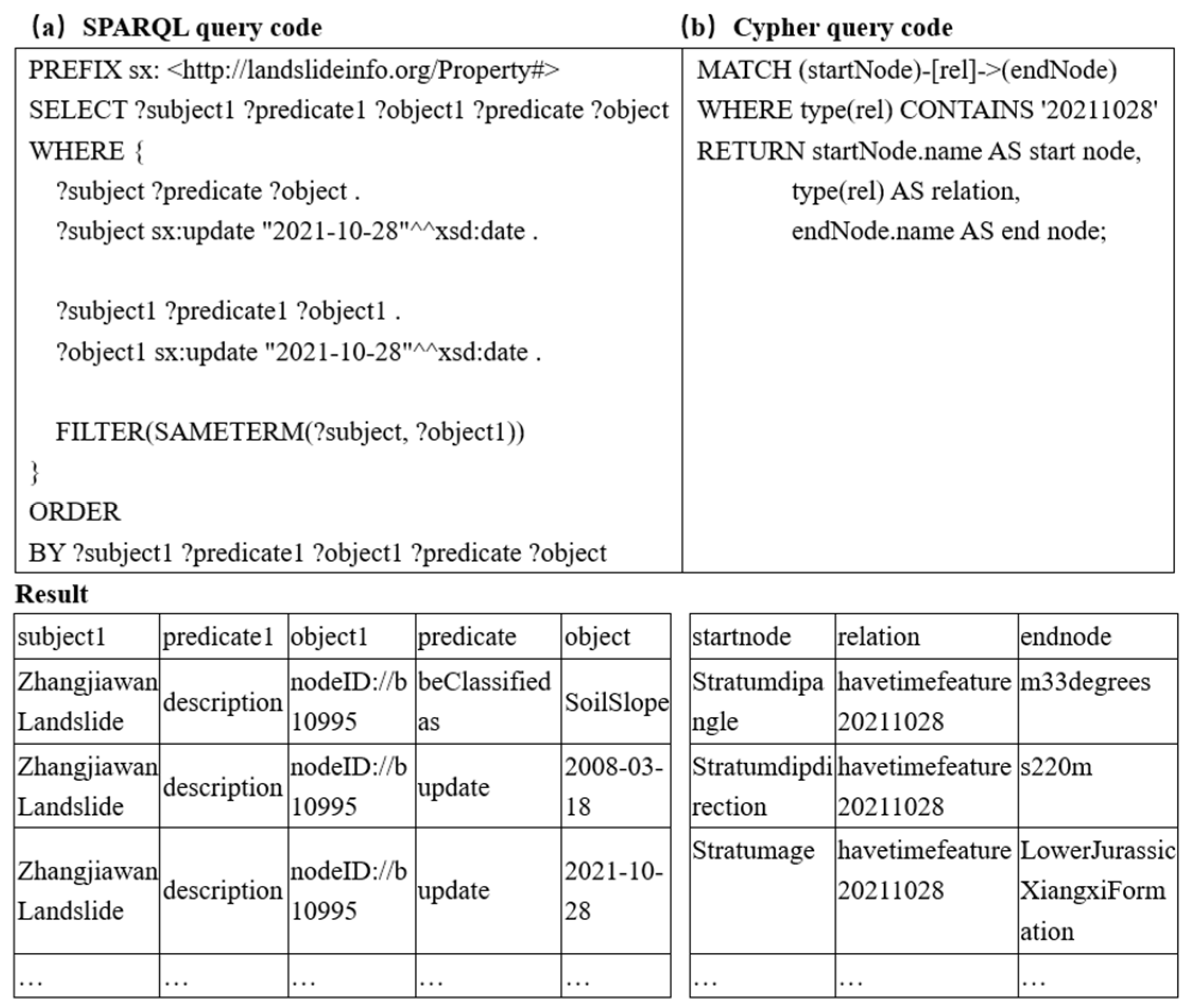
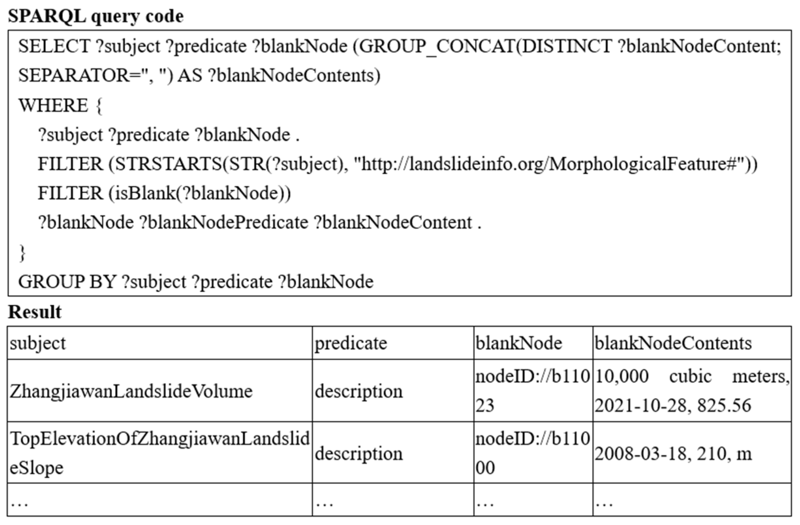
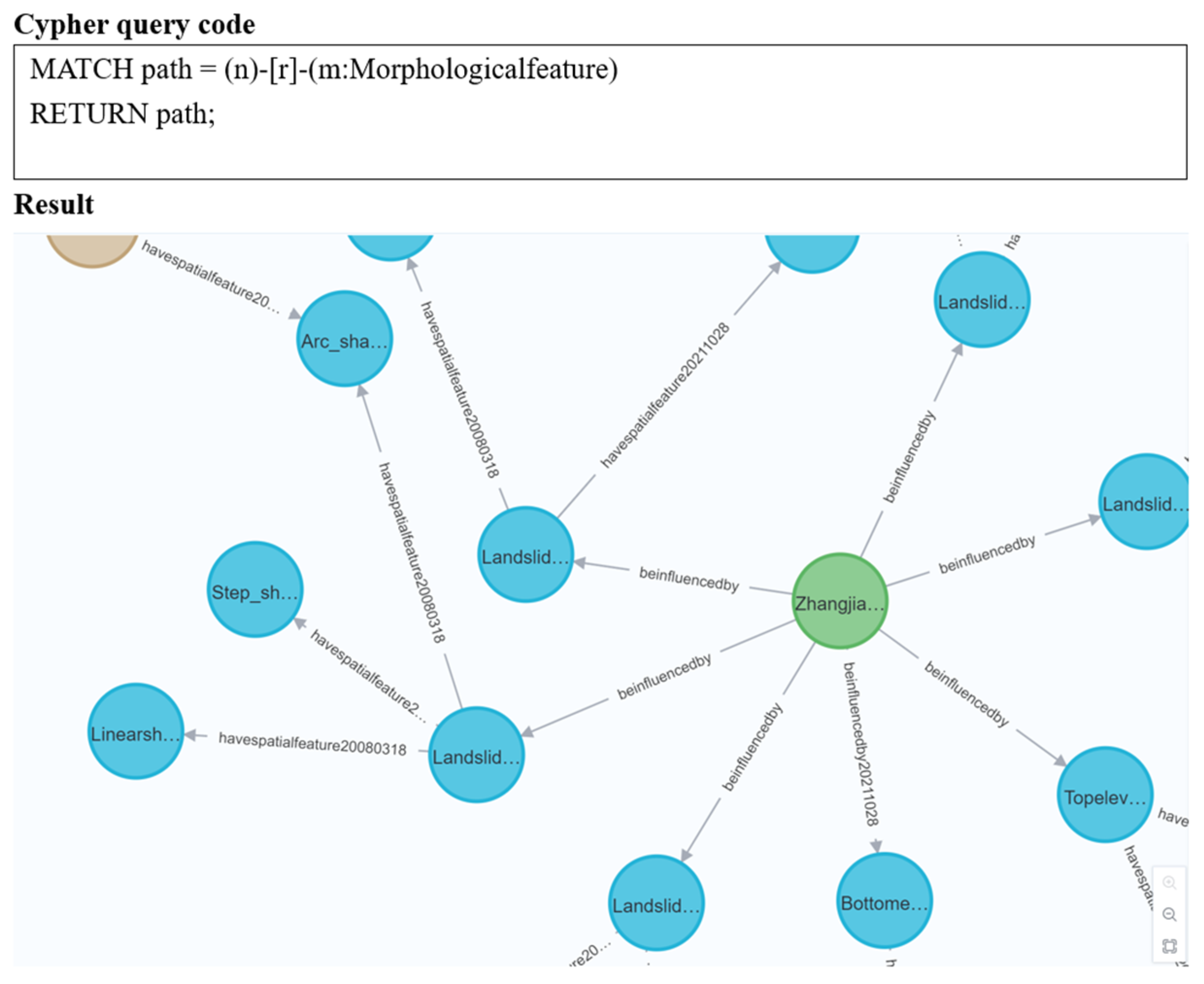
3.3.1. Query Results from the RDF-Based Knowledge Graph

The MTKG provides a comprehensive framework for querying and analyzing the dynamic aspects of landslides. To comprehend the temporal evolution of the Zhangjiawan landslide, the initial step was to query the update times associated with it. This entailed retrieving a list of updates relevant to the “Zhangjiawan landslide” and storing these update times in a list. The list thus obtained serves as a fundamental element for subsequent queries, enabling a chronological analysis of the landslide’s development. Figure 6a visualizes the temporal sequence of updates derived from the query results.
Building on the list of update times, the next query focused on extracting the basic information of the Zhangjiawan landslide for a specific update time, namely, 28 October 2021. This involved querying the blank nodes that contain the update time “28 October 2021” and then retrieving the triples where these blank nodes are involved. The result is a detailed snapshot of the landslide’s basic information as it was recorded on that date. This information is crucial for understanding the state of the landslide at a particular point in time, as shown in Figure 7a.
To gain deeper insights into the physical characteristics of the Zhangjiawan landslide, a query was performed to extract its morphological features. This involved querying the triples where the subject’s namespace is “morph,” followed by retrieving the specific information of the blank nodes in these triples. The results provide a detailed description of the landslide’s morphology, along with the update times of this information. These morphological data are essential for analyzing the landslide’s structure and behavior over time, as shown in Figure 8.
Finally, to understand the deformation situation of the Zhangjiawan landslide, a query was carried out to retrieve information about mass monitoring and mass prevention events. These events include signs and the starting and ending time of deformation. The query focused on blank nodes with the relationship “sx:deform,” extracting specific information related to deformation signs and their temporal aspects, as illustrated in Figure 9a. The above sections detail the various queries performed to extract specific information related to this landslide, demonstrating the interconnected nature of the data.

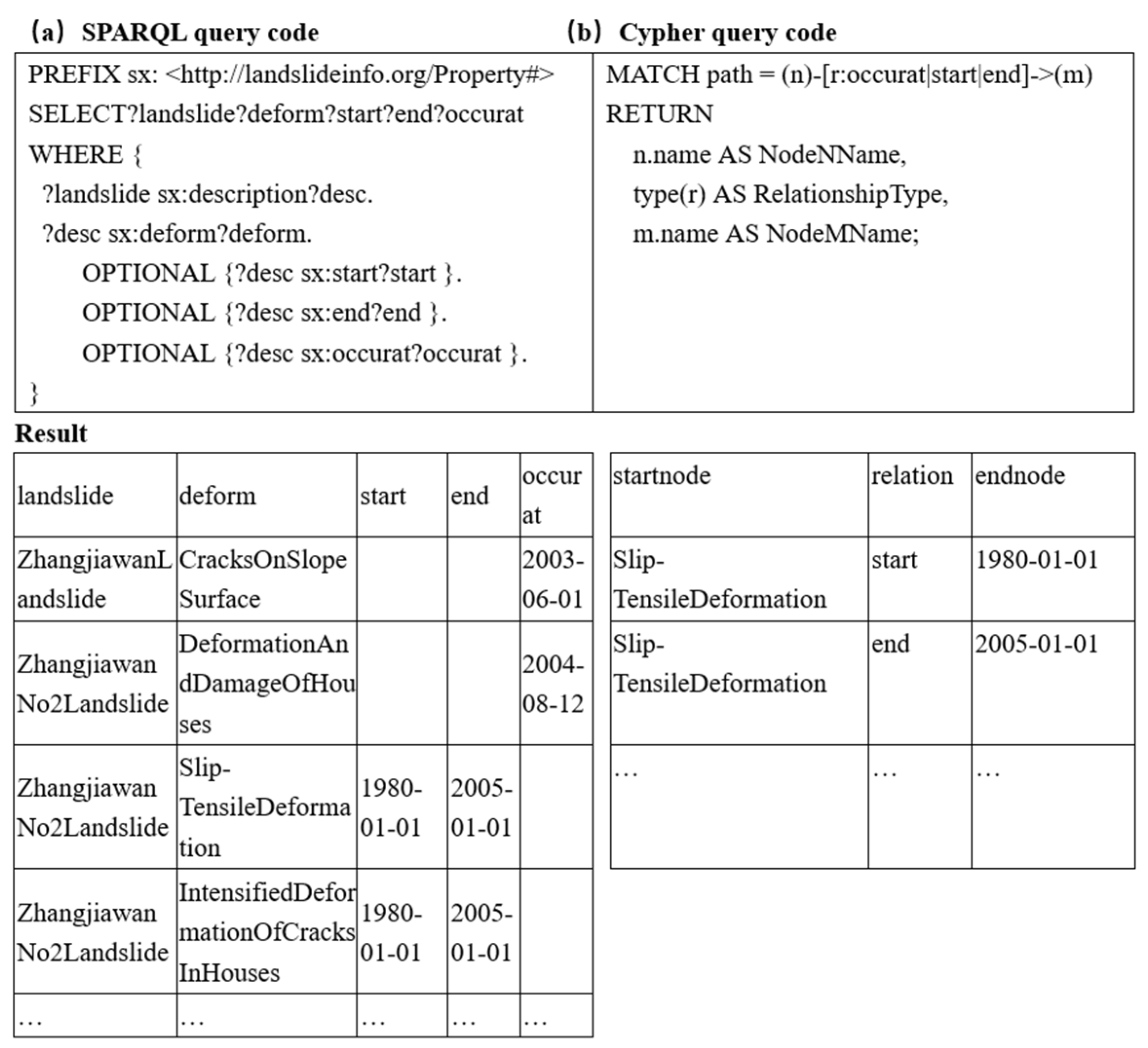
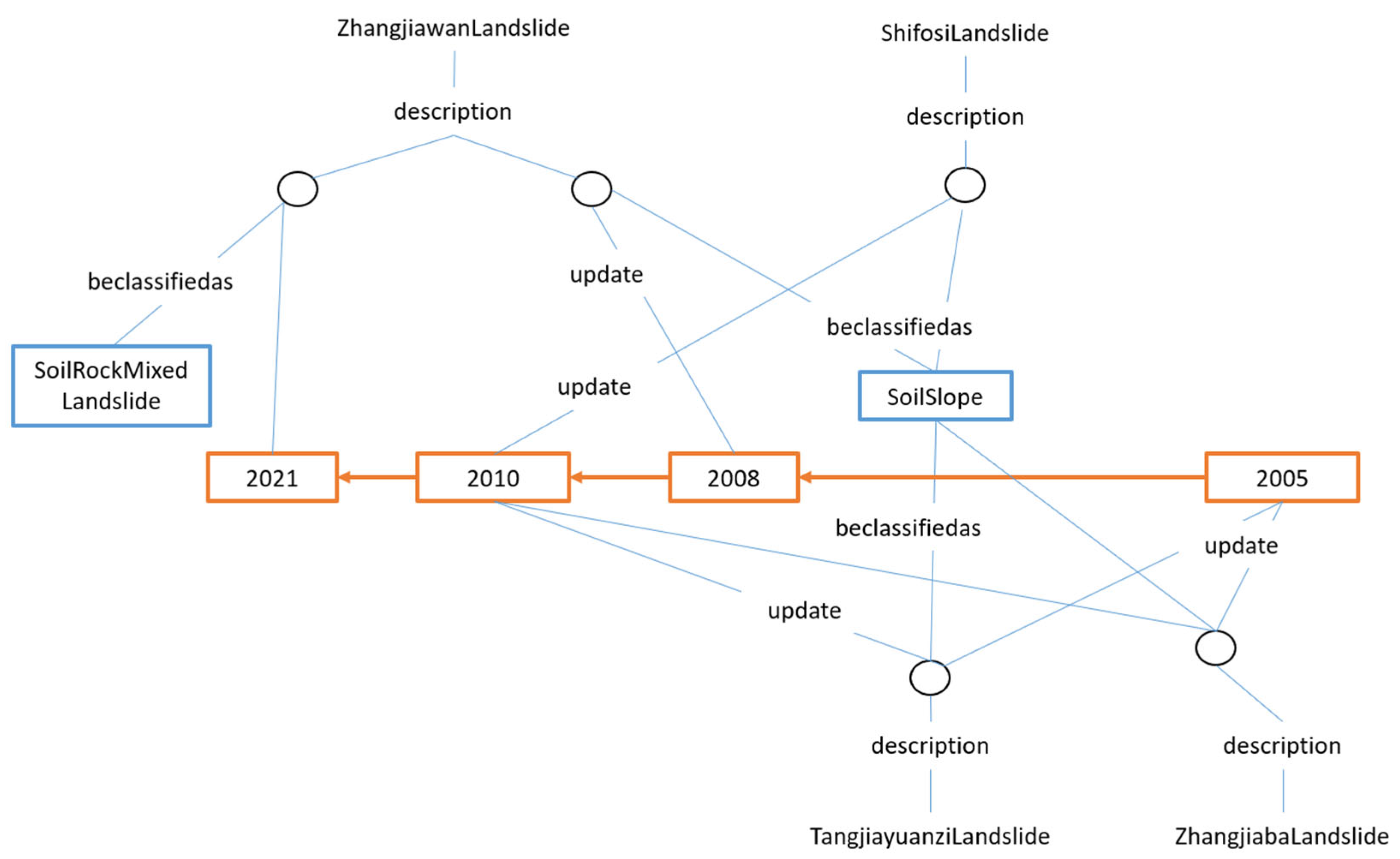
3.3.2. Query Results from the Quadruple-Based Knowledge Graph

The approach to querying the update time sequence in the context of RDF KGs is similar to that of a quadruple KG. Specifically, we focus on the update timeline of the Zhangjiawan landslide. Initially, by querying the update information related to the “Zhangjiawan landslide”, we obtain a series of update timestamps, such as 2021-10-28 and 2008-03-18. These timestamps form the temporal axis for subsequent queries, helping us organize the development trajectory of the landslide in chronological order. The query statement and results are as shown in Figure 6b.
Based on the acquired update times, we concentrate on the pivotal time point of 28 October 2021 and query the basic information of the Zhangjiawan landslide at that moment. Through querying the quadruple KG, we obtain detailed information about the landslide’s strata dip angle, strata dip direction, strata age, landslide area, landslide slope, and other factors. These data corroborate the results obtained via RDF-based KG queries at the same time point, such as the landslide classification being identified as “SoilSlope” in both query methods. The query statement and results are as shown in Figure 7a.
This detailed basic information provides a clear understanding of the static characteristics of the Zhangjiawan landslide as of 28 October 2021. To further explore the morphological characteristics of the Zhangjiawan landslide, we conduct targeted queries in the quadruple KG. By matching nodes and paths related to “Morphologicalfeature,” we acquire descriptions of the landslide’s morphology over time, such as its shape, volume, and elevation at different periods. This information, in conjunction with the previously acquired update times and basic information, allows us to illustrate the trend in the landslide’s morphological changes over time. For example, by comparing the landslide volume data at different time points, we can visually observe the evolution of the landslide’s scale. The corresponding query statement and results are as shown in Figure 10.
Finally, to investigate the community’s response to the Zhangjiawan landslide, we query the quadruple KG for information related to community monitoring and defense events concerning the landslide. By matching nodes with “occurat,” “start,” and “end” relationships, we acquire information such as the occurrence time, start time, and end time of events like surface cracks and damage to buildings caused by the landslide. When correlated with the previously obtained basic information and morphological features of the landslide, these data assist in assessing the effectiveness of community monitoring and defense strategies. The query statement and results are as shown in Figure 9b.
To deeply verify the effectiveness of the multi-temporal knowledge graph in the landslide domain, a systematic comparative analysis is conducted herein between MTKGs and traditional static knowledge graphs in terms of core knowledge processing capabilities. Table 2 compares the differences in landslide domain knowledge processing capabilities between static knowledge graphs and multi-temporal knowledge graphs. In terms of temporal query support, static knowledge graphs lack time retrieval functions, while MTKGs enable flexible temporal data queries by directly filtering temporal attributes through SPARQL. In terms of temporal reasoning capability, static knowledge graphs cannot derive the causal temporal relationships between events, whereas MTKGs can infer event precedence and evolution chains with the aid of a temporal ontology. For historical state backtracking, static knowledge graphs struggle to reproduce historical data states, while the MTKG supports “temporal slicing” queries to obtain the graph state at any historical moment. In terms of feature evolution tracking, static knowledge graphs fail to capture temporal changes in features, whereas MTKGs can query the evolution trajectories of multidimensional features (such as geomorphology and landslide events) within any time interval, enabling temporal correlation analysis between features. This comparison demonstrates that the MTKG significantly outperforms traditional static knowledge graphs in handling dynamic knowledge in the landslide domain, facilitating the analysis of landslide evolution processes.
In the initial stage of this study, the framework was validated using the Zhangjiawan landslide as a case, preliminarily demonstrating the feasibility of multi-temporal knowledge graphs in landslide risk assessment. However, due to the complexity of landslide types, geographical environments, and evolutionary processes, a single case is insufficient to fully cover the diversity of different geological conditions, climatic factors, and triggering mechanisms. To address this limitation, the multi-temporal landslide knowledge graph framework was applied to multiple typical landslide cases. Through a comparative analysis of these cases, the applicability of the framework under complex conditions was further verified, providing a reference for cross-regional and multi-type landslide disaster research. Specific application details are shown in Figure 11.

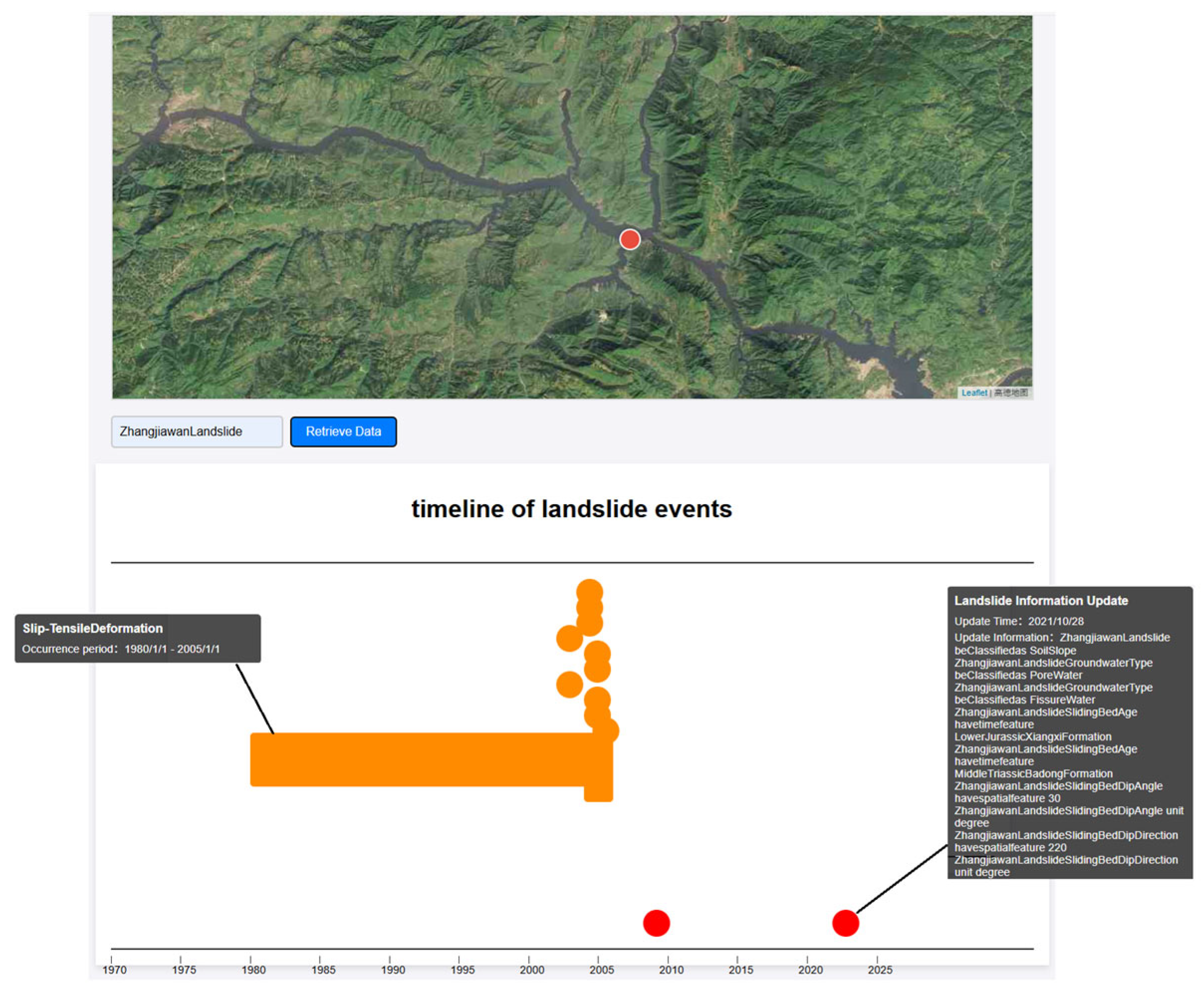
3.4. Web Interface for MTKG Querying

The web interface for MTKG querying offers an interactive framework that enables users to explore landslide information through a structured and visualized methodology. The interface integrates three core components: a query mechanism, a geographic base map, and a dynamic timeline visualization. Users input the name of a landslide, which triggers the retrieval of geographic coordinates corresponding to the landslide’s location. These coordinates are displayed on a map interface powered by the a map API (https://developer.amap.com/demo/javascript-api/example/map/map-english/, accessed on 23 March 2025). The timeline visualization presents a chronological sequence of landslide-related events and data updates, with nodes representing discrete events or updates to information. The width of each node is proportional to the temporal span of the event or update, thereby providing a visual representation of the landslide’s historical progression over time.
The system’s operational workflow commences with user input, wherein the landslide name is translated into a SPARQL query to access the MTKG. This query is executed through a dedicated endpoint, leveraging Python3.7 to process and visualize the retrieved data. The timeline dynamically arranges nodes in chronological order, distinguishing between two categories of information: versioned updates of landslide data and specific landslide-related events. This structured approach enables users to analyze both spatial and temporal dimensions of landslide occurrences, thereby facilitating a comprehensive understanding of landslide dynamics and their evolution.
By integrating frontend and backend functionalities, the system enables the real-time querying and visualization of landslide data. The combination of geographic mapping and dynamic timeline visualization provides an intuitive method for interpreting complex spatiotemporal relationships. The design of the timeline, with nodes reflecting temporal duration and event details, enhances the clarity of landslide evolution, making the interface a valuable analytical tool for researchers and practitioners in landslide risk assessment and management. This methodology not only optimizes data retrieval but also supports decision-making processes through its structured visualization of temporal and spatial information, thereby advancing the efficiency and accuracy of landslide-related analyses. Figure 12 shows the query results of the Zhangjiawan landslide.

4. Discussion

4.1. Core Innovations and Practical Value of MTKG

The necessity of constructing a multi-temporal knowledge graph for landslides is evident. The inducing factors of landslides change over time, thereby affecting the activity characteristics of landslides. For instance, factors subject to temporal variations such as permafrost degradation at high altitudes and changes in precipitation patterns due to climate change can alter the triggering conditions of landslides [38]. Moreover, unlike the static model that only updates information within the framework, the dynamic framework can systematically record the long-term evolution process of landslides. Based on the theory of landslide path dependency, historical evolution information is of value for current landslide research [25]. Static knowledge graphs and traditional databases fail to address this: Static graphs miss dynamic changes, while relational databases lack semantic relations, hindering intelligent early warning.
The MTKG framework resolves these issues by introducing a temporal dimension, integrating multi-source time-series data, and building a semantic network to track landslide evolution. It overcomes static graph limitations via dynamic evolution recording, temporal reasoning, and historical backtracking (using version control with quadruples/blank nodes and “time-slice” queries). For databases, it enhances semantic expression and multi-source integration through ontology modeling and knowledge extraction, supporting monitoring and early warning.
Compared to existing technologies, the MTKG excels in multi-source data integration (e.g., geological texts, reports, tabular/unstructured records). BIM/digital twins focus on single-object simulation, lacking regional geological/historical case integration, limiting cross-scale/scenario reuse. The MTKG’s standardized representation enables cross-regional comparison and experience transfer. Unlike BIM/digital twins (rule-driven, fixed models, restricted to known hazards, and costly), the MTKG is “knowledge–data joint-driven”, using unstructured knowledge to form a time-aware base. Compared to traditional static landslide graphs, the MTKG enables full-lifecycle modeling via versioned updates and event sequences, advancing the field from “data storage” to “intelligent early warning”.
The MTKG’s core value lies in combining the “temporal dimension” and “semantic network”, advancing from data storage to knowledge reasoning—supporting precise monitoring, dynamic early warning, and scientific prevention.

4.2. Technical Implementation and Effectiveness of Dynamic Queries

This study successfully validated the practical value of the MTKG dynamic information tracking through SPARQL and Cypher queries. For instance, querying versioned information of the Zhangjiawan landslide (Figure 4) reveals that its elevation was updated from 210 m in 2008 to 260 m in 2021. Additionally, the sliding surface stratigraphic information has been progressively refined with advancements in exploration technology, demonstrating the temporal evolution characteristics of landslides. Event-based queries further elucidate the temporal variations in deformation features (such as crack propagation intensity). The results not only validate the data integrity of the MTKG but also offer direct evidence for phased landslide risk assessment. For instance, potential hazards during accelerated deformation phases can be identified through temporal sequence analysis.
The implementation of dynamic queries relies on the structured design of RDF-based and quadruple-based architectures. By embedding temporal attributes into triples, the MTKG transforms static facts into temporal event chains. SPARQL employs temporal filtering conditions (e.g., FILTER (?time = “2021-10-28”)) to precisely extract landslide states at specific timestamps, while Cypher utilizes path matching (e.g., WHERE type(rel) CONTAINS ‘20211028’) for temporal state retrieval. Furthermore, blank nodes effectively manage versioned updates, prevent global identifier conflicts, and ensure the efficient storage/retrieval of dynamic data.
The MTKG query web interface significantly enhances user access to the KG. By allowing users to input landslide names and retrieve location/time-axis data, it provides an intuitive way to explore landslide information. The integration of a map API and the time-axis design enhances visualization, making it easier for users to understand the spatial and temporal distribution of landslides. However, challenges remain, especially regarding data updates. Ensuring the timely and accurate refresh of data in the KG is crucial for maintaining its usefulness and reliability for users.

4.3. Current Challenges and Further Works

While the MTKG demonstrates effectiveness in temporal modeling, its dynamic representation faces three critical challenges. First, the heterogeneity of multi-source data complicates temporal alignment, often requiring manual annotation or complex ETL (extract–transform–load) processes. Second, the lack of integration with real-time monitoring data (e.g., displacement measurements and rainfall records) limits its applicability in early warning systems. Third, maintaining semantic consistency is hindered by ambiguous definitions of concepts like “landslide triggers” across sources, which necessitates ontology reasoning or external knowledge bases for disambiguation.
To advance the MTKG beyond its current basic functionality and query services, several areas require further development. First, enhancing the graph’s accuracy and coverage depends on integrating more interdisciplinary expert knowledge to expand domain knowledge diversity and dataset comprehensiveness. Second, optimizing temporal data processing is critical to accurately capturing the complex evolution of landslide-related events; this includes refining the data update mechanism to improve the performance and user experience of the MTKG query web interface. Finally, the web interface itself should be upgraded to enhance user interaction, with more intuitive and effective visualization features to facilitate better understanding and analysis of dynamic changes in landslides.

5. Conclusions

This study proposed a framework for constructing an MTKG, which systematically integrates multi-source time series data (e.g., displacement, rainfall, seismic activity) and temporal attributes to provide a structured foundation for modeling the dynamic evolution of landslides. The MTKG advances landslide research by bridging the gap in static KGs, enabling time-resolved representation of critical parameters (e.g., the versioned updates of landslide attributes, event sequences). The key conclusions are as follows:
(1)
Construction: The MTKG effectively formalizes dynamic landslide knowledge through RDF-based version control and multi-time series quadruples (subject–predicate–object–timestamp), capturing updates such as elevation revisions and refinements to geological age.
(2)
Application: Through multi-dimensional queries implemented via SPARQL and Cypher, MTKGs support the extraction of dynamic knowledge from multiple dimensions, including time, entity attributes, and events.
Future work will focus on the following:
(1)
Extending the MTKG into a spatiotemporal KG by embedding spatial attributes (e.g., crack network geometries) to model coupled time–space landslide behaviors.
(2)
Developing multi-time series embedding techniques to enhance dynamic reasoning across heterogeneous temporal resolutions (hourly, daily, and event-based).
(3)
Coupling the MTKG with machine learning models to enable predictive analytics (e.g., forecasting displacement thresholds based on historical time series trends).

Author Contributions

Conceptualization, R.W. and C.W.; methodology, R.W.; software, M.H.; validation, R.W., M.H., and C.W.; formal analysis, Z.L.; investigation, J.H.; resources, R.W.; data curation, H.M. (Haishan Ma); writing—original draft preparation, R.W. and M.H.; writing—review and editing, R.W., and C.W.; visualization, H.M. (Hongbo Mei); supervision, R.W.; project administration, R.W. and J.H. All authors have read and agreed to the published version of the manuscript.

Funding

This research was funded by the Construction of a subsequent geological disaster prevention and control information system in the Three Gorges Reservoir Area (0001212012AC50001).

Data Availability Statement

No new data were created or analyzed in this study.

Conflicts of Interest

The authors declare no conflict of interest.

Abbreviations

The following abbreviations are used in this manuscript:
RDFResource Description Framework
KGKnowledge Graph
MTKGMulti-Temporal Knowledge Graph

References

  1. Chen, L.; Ge, X.; Yang, L.; Li, W.; Peng, L. An Improved Multi-Source Data-Driven Landslide Prediction Method Based on Spatio-Temporal Knowledge Graph. Remote Sens. 2023, 15, 2126. [Google Scholar] [CrossRef]
  2. Li, Y.; Wang, D.; Ma, Z.; Fan, Y.; Yang, B.; Liu, L.; Luo, C. Multi-source remote sensing landslide hazard identification method driven by knowledge graph. Bull. Surv. Mapp. 2024, 1, 12–18, (In Chinese with English Abstract). [Google Scholar] [CrossRef]
  3. Xu, Q.; Cui, S.; Huang, W.; Pei, X.; Fan, X.; Ai, Y.; Zhao, W.; Luo, Y.; Luo, J.; Liu, M.; et al. Construction of a Landslide Knowledge Graph in the Field of Engineering Geology. Geomat. Inf. Sci. Wuhan Univ. 2023, 48, 1601–1615, (In Chinese with English Abstract). [Google Scholar]
  4. Zhu, Q.; Zeng, H.W.; Ding, Y.L.; Xie, X.; Liu, F.; Zhang, L.G.; Li, H.F.; Hu, H.; Zhang, J.X.; Chen, L.; et al. Review of Analysis Methods for Major Landslide Hazards. Acta Geod. Cartogr. Sin. 2019, 48, 1551–1561. [Google Scholar]
  5. Hogan, A.; Blomqvist, E.; Cochez, M.; D’amato, C.; Melo, G.D.; Gutierrez, C.; Kirrane, S.; Gayo, J.E.L.; Navigli, R.; Neu-maier, S.; et al. Knowledge Graphs. ACM Comput. Surv. 2021, 54, 71. [Google Scholar] [CrossRef]
  6. Ma, X. Knowledge Graph Construction and Application in Geosciences: A Review. Comput. Geosci. 2022, 161, 105082. [Google Scholar] [CrossRef]
  7. Wang, C.; Li, Y.; Chen, J.; Ma, X. Named Entity Annotation Schema for Geological Literature Mining in the Domain of Porphyry Copper Deposits. Ore Geol. Rev. 2023, 152, 105243. [Google Scholar] [CrossRef]
  8. Harnoune, A.; Rhanoui, M.; Mikram, M.; Yousfi, S.; Elkaimbillah, Z.; El Asri, B. BERT Based Clinical Knowledge Extraction for Biomedical Knowledge Graph Construction and Analysis. Comput. Methods Programs Biomed. Update 2021, 1, 100042. [Google Scholar] [CrossRef]
  9. Luan, Y.; He, L.; Ostendorf, M. Multi-Task Identification of Entities, Relations, and Coreference for Scientific Knowledge Graph Construction. arXiv 2018, arXiv:1808.09602. [Google Scholar] [CrossRef]
  10. Wang, C.; Ma, X.; Chen, J.; Chen, J. Information Extraction and Knowledge Graph Construction from Geoscience Literature. Comput. Geosci. 2018, 112, 112–120. [Google Scholar] [CrossRef]
  11. Jin, Y.; von Seelen, W.; Sendhoff, B. An Approach to Rule-Based Knowledge Extraction. In Proceedings of the 1998 IEEE International Conference on Fuzzy Systems Proceedings, Anchorage, AK, USA, 4–9 May 1998; IEEE: Piscataway, NJ, USA, 1998; Volume 2, pp. 1188–1193. [Google Scholar]
  12. Sobhana, N.V.; Mitra, P.; Ghosh, S.K. Conditional Random Field Based Named Entity Recognition in Geological Text. Int. J. Comput. Appl. 2010, 1, 143–147. [Google Scholar] [CrossRef]
  13. Qiu, Q.; Xie, Z.; Wu, L.; Tao, L.; Li, W. BiLSTM-CRF for Geological Named Entity Recognition from Geoscience Literature. Earth Sci. Inform. 2019, 12, 565–579. [Google Scholar] [CrossRef]
  14. Wu, R.; Zhu, M.; Fu, X.; Mei, H.; Li, Z.; Zhang, L.; Wang, H.; Tu, Q. Construction of Geological Hazard Trend Prediction Model and Early Warning System in Three Gorges Reservoir Area. South China Geol. 2023, 39, 455–469, (In Chinese with English Abstract). [Google Scholar]
  15. Wang, B.; Wu, L.; Xie, Z.; Qiu, Q.; Zhou, Y.; Ma, K.; Tao, L. Understanding Geological Reports Based on Knowledge Graphs Using a Deep Learning Approach. Comput. Geosci. 2022, 168, 105229. [Google Scholar] [CrossRef]
  16. Fan, R.; Wang, L.; Yan, J.; Song, W.; Zhu, Y.; Chen, X. Deep Learning-Based Named Entity Recognition and Knowledge Graph Construction for Geological Hazards. ISPRS Int. J. Geo-Inf. 2020, 9, 15. [Google Scholar] [CrossRef]
  17. Dagdelen, J.; Dunn, A.; Lee, S.; Walker, N.; Rosen, A.S.; Ceder, G.; Persson, K.A.; Jain, A. Structured Information Extraction from Scientific Text with Large Language Models. Nat. Commun. 2024, 15, 1418. [Google Scholar] [CrossRef]
  18. Zhang, Y.; Zhu, J.; Zhu, Q.; Xie, Y.; Li, W.; Fu, L.; Zhang, J.; Tan, J. The Construction of Personalized Virtual Landslide Dis-aster Environments Based on Knowledge Graphs and Deep Neural Networks. Int. J. Digit. Earth 2020, 13, 1637–1655. [Google Scholar] [CrossRef]
  19. Ge, X.; Yang, Y.; Chen, J.; Li, W.; Huang, Z.; Zhang, W.; Peng, L. Disaster Prediction Knowledge Graph Based on Multi-Source Spatio-Temporal Information. Remote Sens. 2022, 14, 1214. [Google Scholar] [CrossRef]
  20. Ma, L.; Wang, J.; Cheng, J.; Wang, X.; Zhu, W. MLRP-KG: Mine Landslide Risk Prediction Based on Knowledge Graph. IEEE Trans. Artif. Intell. 2022, 3, 78–87. [Google Scholar] [CrossRef]
  21. Wu, Q.; Xie, Z.; Tian, M.; Qiu, Q.; Chen, J.; Tao, L.; Zhao, Y. Integrating Knowledge Graph and Machine Learning Methods for Landslide Susceptibility Assessment. Remote Sens. 2024, 16, 2399. [Google Scholar] [CrossRef]
  22. Liu, H.; Ding, Q.; Yang, X. A Knowledge-Guided Approach for Landslide Susceptibility Mapping Using Convolutional Neural Net-work and Graph Contrastive Learning. Sustainability 2024, 16, 4547. [Google Scholar] [CrossRef]
  23. Zhang, Y.; Zhang, J.; Dong, L. Fuzzy Logic Regional Landslide Susceptibility Multi-Field Information Map Representation Analysis Method Constrained by Spatial Characteristics of Mining Factors in Mining Areas. Processes 2023, 11, 985. [Google Scholar] [CrossRef]
  24. Xu, Q.; Tang, M.G.; Xu, K.X.; Huang, X.B. Study on the Temporal and Spatial Evolution Law and Early Warning and Forecast of Landslides. Chin. J. Rock Mech. Eng. 2008, 27, 1104–1112, (In Chinese with English Abstract). [Google Scholar]
  25. Samia, J.; Temme, A.; Bregt, A.; Wallinga, J.; Guzzetti, F.; Ardizzone, F.; Rossi, M. Do Landslides Follow Landslides? In-sights in Path Dependency from a Multi-Temporal Landslide Inventory. Landslides 2017, 14, 547–558. [Google Scholar] [CrossRef]
  26. Ma, M.; Wang, J.L.; Chen, Q.; Li, J. Regional Landslide Susceptibility Evaluation Based on Information Value Weighted by Random Forest: A Case Study from Zigui to Badong Section in the Three Gorges Reservoir Area. South China Geol. 2024, 40, 749–763, (In Chinese with English Abstract). [Google Scholar]
  27. Zhou, C.; Yin, K.; Cao, Y.; Ahmed, B.; Li, Y.; Catani, F.; Pourghasemi, H.R. Landslide Susceptibility Modeling Applying Machine Learning Methods: A Case Study from Longju in the Three Gorges Reservoir Area, China. Comput. Geosci. 2018, 112, 23–37. [Google Scholar] [CrossRef]
  28. Li, M.; Jiang, W.J.; Dong, J.H.; Jin, S.; Zhang, C.; Niu, R. Landslide Disaster Susceptibility Evaluation Based on Machine Learning: A Case Study of the Three Gorges Reservoir Area. South China Geol. 2023, 39, 413–427, (In Chinese with English Abstract). [Google Scholar]
  29. Yang, S.S.; Ye, R.Q.; Fu, X.L.; Wu, R.; Xiong, N.; Wen, T. Research on the Warning Rainfall Threshold of Rainfall–Induced Landslides in the Three Gorges Reservoir Area. South China Geol. 2023, 39, 445–454, (In Chinese with English Abstract). [Google Scholar]
  30. Tang, X.; Feng, Z.; Xiao, Y.; Wang, M.; Ye, T.; Zhou, Y.; Meng, J.; Zhang, B.; Zhang, D. Construction and Application of an Ontology-Based Domain-Specific Knowledge Graph for Petroleum Exploration and Development. Geosci. Front. 2023, 14, 101426. [Google Scholar] [CrossRef]
  31. Lacroix, T.; Obozinski, G.; Usunier, N. Tensor Decompositions for Temporal Knowledge Base Completion. arXiv 2020, arXiv:2004.04926. [Google Scholar] [CrossRef]
  32. Zhou, C.; Wang, H.; Wang, C.; Hou, Z.; Zheng, Z.; Shen, S.; Cheng, Q.; Feng, Z.; Wang, X.; Lv, H.; et al. Geoscience Knowledge Graph in the Big Data Era. Sci. China Earth Sci. 2021, 64, 1105–1114. [Google Scholar] [CrossRef]
  33. Yang, B.; Yin, K.; Lacasse, S.; Liu, Z. Time Series Analysis and Long Short-Term Memory Neural Network to Predict Land-slide Displacement. Landslides 2019, 16, 677–694. [Google Scholar] [CrossRef]
  34. Ebrahim, K.M.P.; Fares, A.; Faris, N.; Zayed, T. Exploring Time Series Models for Landslide Prediction: A Literature Review. Geoenviron. Disasters 2024, 11, 25. [Google Scholar] [CrossRef]
  35. Lombardo, L.; Opitz, T.; Ardizzone, F.; Guzzetti, F.; Huser, R. Space-Time Landslide Predictive Modelling. Earth-Sci. Rev. 2020, 209, 103318. [Google Scholar] [CrossRef]
  36. Shi, P.J. Theory and practice on disaster system research in a fourth time. J. Nat. Disasters 2005, 18, 1–9. [Google Scholar]
  37. RobatJazi, M.; Reformat, M.Z.; Pedrycz, W.; Musilek, P. Querying RDF Data with Imprecise Time Phrases. In Proceedings of the 2015 IEEE/WIC/ACM International Conference on Web Intelligence and Intelligent Agent Technology (WI-IAT), Singapore, 6–9 December 2015; IEEE: Singapore, Singapore, 2015; pp. 445–450. [Google Scholar]
  38. Crozier, M.J. Deciphering the effect of climate change on landslide activity: A review. Geomorphology 2010, 124, 260–267. [Google Scholar] [CrossRef]
Figure 1. Technique procedure in this study. This workflow centers around the construction and application of the landslide temporal knowledge graph. It begins with landslide-related data in the form of tabular and textual data. With the semantic guidance of the landslide temporal ontology, the tabular data are processed through mapping, and the text data are manually annotated. These two types of data are then converted into knowledge graphs based on the RDF and quadruples. For the RDF-based KG, storage tools such as Virtuoso are commonly used, and queries are made using SPARQL. Finally, through the web interface for MTKG querying, the query function is utilized, enabling users to conduct information retrieval and analysis related to landslide temporality based on the constructed knowledge graph.
Geohazards 06 00039 g001
Figure 2. The landslide disaster chain diagram. The disaster-forming system forms a closed loop as follows: pregnant disaster environment (long-term stable elements such as topography and stratigraphy) → disaster-causing factors (triggered by internal/external forces) → disaster-forming process (ac-cumulation of disaster degree exceeding the threshold) → disaster consequences (disaster events) → engineering response (exploration and governance measures). The temporal knowledge deepens the connotation of the time dimension through color modules: The blue module (stable basic attributes), the orange module (landslide-related events), and the green module (information version iteration) serve as a static reference benchmark, connect the dynamic temporal evolution chain, and record the cognitive upgrade process, respectively.
Geohazards 06 00039 g002
Figure 3. Blank node implementation for the versioned updates of landslide attributes. Yellow highlights represent key concepts/instances. Green highlights represent relations. (A) Ontology definition: This defines classes related to landslides. “ge:Landslide” is a class, and “ge:GeographicalEntity” is also a class. “ge:SlidingMass”, “ge:SlidingBed”, and “ge:SlidingSurface” are sub-classes of “ge:GeographicalEntity”, structuring the concept system related to landslides. (B) Instance definition: This defines the “ge:ZhangjiawanLandslide” instance. Its “sx:description” property contains two sets of classification information and update dates, recording the classification and historical situation of this instance. (C) Mapping between ontology and instances: This links the “ge:ZhangjiawanLandslide” to the “ge:Landslide” class. This also defines “geo:GuojiabaTown, ZiguiCounty, HubeiProvince” as a geographical location and specifies that this landslide is located there, inking the instance to the ontology.
Geohazards 06 00039 g003
Figure 4. The MTKG of the Zhangjiawan landslide based on RDF, illustrating morphological, scale, and relational features. The construction method of the multi-temporal knowledge graph for landslides based on RDF introduces an intermediate blank node directly between the head entity and the tail entity to resolve conflicts in temporal expression.
Geohazards 06 00039 g004
Figure 5. The MTKG of the Zhangjiawan landslide based on the quadruple structure. This time dimension represents the update time of the information characterized by the triple. During the process of storing data in the Neo4j database, the time dimension is bound and represented through semantic relationships.
Geohazards 06 00039 g005
Figure 6. (a) Query results of information update times for the Zhangjiawan landslide (RDF-based query results). This figure demonstrates the results of retrieving historical information update times for the Zhangjiawan landslide from an RDF-based knowledge graph using SPARQL queries. The query returns two timestamps, 18 March 2008 and 28 October 2021, indicating that version updates of landslide-related data occurred on these dates. (b) Query results of information update times for the Zhangjiawan landslide (quadruple-based query results). This figure shows the results of retrieving the information update times of the Zhangjiawan landslide via a Cypher query.
Geohazards 06 00039 g006
Figure 7. (a) Query results of basic attribute information of the Zhangjiawan landslide on 28 October 2021 (RDF-based query results). This figure shows the basic information of the Zhangjiawan landslide retrieved via a SPARQL query on 28 October 2021, including static attributes (e.g., topography, geological structure) and dynamic update records documented at this time point. (b) Query results of basic attribute information of the Zhangjiawan landslide on 28 October 2021 (quadruple-based query results). This figure displays the results of retrieving attribute information for the Zhangjiawan landslide on 28 October 2021, via a Cypher query. The query matches nodes and relationships in the graph, filters out data where the relationship type contains “20211028”, and returns landslide-related attributes, including the stratum dip angle, dip direction, area, slope, and other relevant information.
Geohazards 06 00039 g007
Figure 8. Query results of temporal sequence evolution of morphological characteristics of the Zhangjiawan landslide (RDF-based query results). This figure presents the temporal sequence evolution data of morphological characteristics of the Zhangjiawan landslide retrieved via a SPARQL query from an RDF knowledge graph, including morphological parameters (such as the landslide boundary, elevation, and slope gradient) recorded at different time points and their variation processes.
Geohazards 06 00039 g008
Figure 9. (a) Query results of temporal sequence evolution of mass monitoring and prevention events for the Zhangjiawan landslide (RDF-based query results). This figure illustrates the temporal sequence evolution of data from mass monitoring and prevention events for the Zhangjiawan landslide, obtained through SPARQL queries, including mass monitoring data (such as crack development and soil displacement) recorded at various time points or periods. (b) Query results of temporal sequence evolution of mass monitoring and prevention events for Zhangjiawan landslide (quadruple-based query results). This figure utilizes a Cypher query to match nodes and relationship paths related to the time sequence of mass monitoring and prevention events and obtains the time series information of such events for the Zhangjiawan landslide. It returns the names of nodes and the types of relationships associated with the events, presenting the time sequence evolution data, including the start (e.g., 1 January 1980) and end (e.g., 1 January 2005) of the events.
Geohazards 06 00039 g009
Figure 10. Query results of the temporal sequence evolution of morphological characteristics of Zhangjiawan landslide (quadruple-based query results). This figure uses Cypher queries to match nodes and relationship paths related to “Morphologicalfeature” and presents the morphological characteristics of the landslide (such as nodes like the landslide mass, terrain features, and their associated relationships) in the form of a graph.
Geohazards 06 00039 g010
Figure 11. Application of the multi-temporal landslide knowledge graph framework in multiple cases. Blue boxes represent landslide classification types. Orange boxes represent the update time points of classification information.This diagram illustrates the application of the multi-temporal knowledge graph framework to multiple landslide cases. Taking the Zhangjiawan Landslide, Shifosi Landslide, Tangjiayuanzi Landslide, and Zhangjiaba Landslide as examples, it presents the classification relationships of these landslides (indicated by “beclassifiedas”; for instance, the Shifosi Landslide is categorized as the “SoilSlope” type), the update time of the classification information (such as 2005 and 2008), and the temporal topological relationships of the update times (where earlier times point to later times).
Geohazards 06 00039 g011
Figure 12. Web interface for MTKG querying. The red node on the map indicates the geographic location of the Zhangjiawan landslide.The red nodes in the timeline indicate the time points for landslide information updates; the red nodes in the timeline represent the time points for landslide-related events.
Geohazards 06 00039 g012
Table 1. Summary of landslide domain knowledge.
Primary Label (Annotation Tag)Secondary Label
Basic Characteristics of LandslidesGeographical EntitiesLandslide, sliding mass, sliding bed, sliding surface, sliding zone soil, and controlling structural plane
Landslide Classification
Geographical Location
Morphological CharacteristicsInclination and dip of sliding bed (controlling structural plane and sliding surface)
Original slope height and gradient
Planar (profile) shape of the landslide
Scale CharacteristicsLength, width, and thickness of the landslide
Slope gradient and orientation of the landslide
Area and volume of the landslide
Elevation of the slope toe and crest
Depth and thickness of the sliding surface
Properties of Landslide ElementsType of controlling structural plane
Lithology and structure of sliding mass
Lithology and era of the sliding bed
Morphology of the sliding surface
Characteristics of sliding zone soil
Overview of Geological EnvironmentTopography and Landform
StratigraphyStratigraphic era
Stratigraphic lithology
Inclination and dip of strata
Structure and Seismic ActivityStructural position
Seismic intensity
HydrogeologyType of groundwater
Groundwater depth
Groundwater recharge type
Annual average rainfall, maximum daily (hourly) rainfall, and flood (drought) water levels
Human Engineering and ActivitiesType of activity
Time of activity
Landslide-related EventsCommunity Monitoring and Prevention EventsSigns of deformation
Deformation time
Disaster EventsLandslide time
Disaster level
Signs of deformation
Triggering factors
Adverse Reservoir Water Level Changes and Rainfall EventsWater level changes and rainfall
Change time and rainfall time
Mitigation Engineering EventsMitigation measures
Time of mitigation
Table 2. Summary of landslide domain knowledge categories.
IndicatorStatic Knowledge GraphMulti-Temporal Knowledge Graph (MTKG)
Support for temporal queriesUnable to query timeSupports temporal queries (e.g., SPARQL directly filters the sx:update temporal attribute)
Temporal reasoning capabilityUnable to infer temporal causality (e.g., cannot determine the temporal dependency of “rainfall → landslide”)Can infer “event precedence and evolution chains” through the temporal ontology (e.g., deducing “landslide deformation the day after rainfall”)
Historical temporal rewind capabilityUnable to rewind historical states (e.g., cannot query “2020 landslide evolution snapshot”)Supports “temporal slicing” queries, enabling the retrieval of the graph’s state at any historical time point
Feature evolution tracking capabilityUnable to track feature changes over timeCan query the evolution trajectories of features over any time interval, supporting multi-dimensional feature (geomorphology, landslide events, etc.) temporal correlation analysis
Disclaimer/Publisher’s Note: The statements, opinions and data contained in all publications are solely those of the individual author(s) and contributor(s) and not of MDPI and/or the editor(s). MDPI and/or the editor(s) disclaim responsibility for any injury to people or property resulting from any ideas, methods, instructions or products referred to in the content.

