Analysis and Application of the CAUSE Model in Regional Disaster Prevention Measures


Abstract
1. Introduction
2. Method
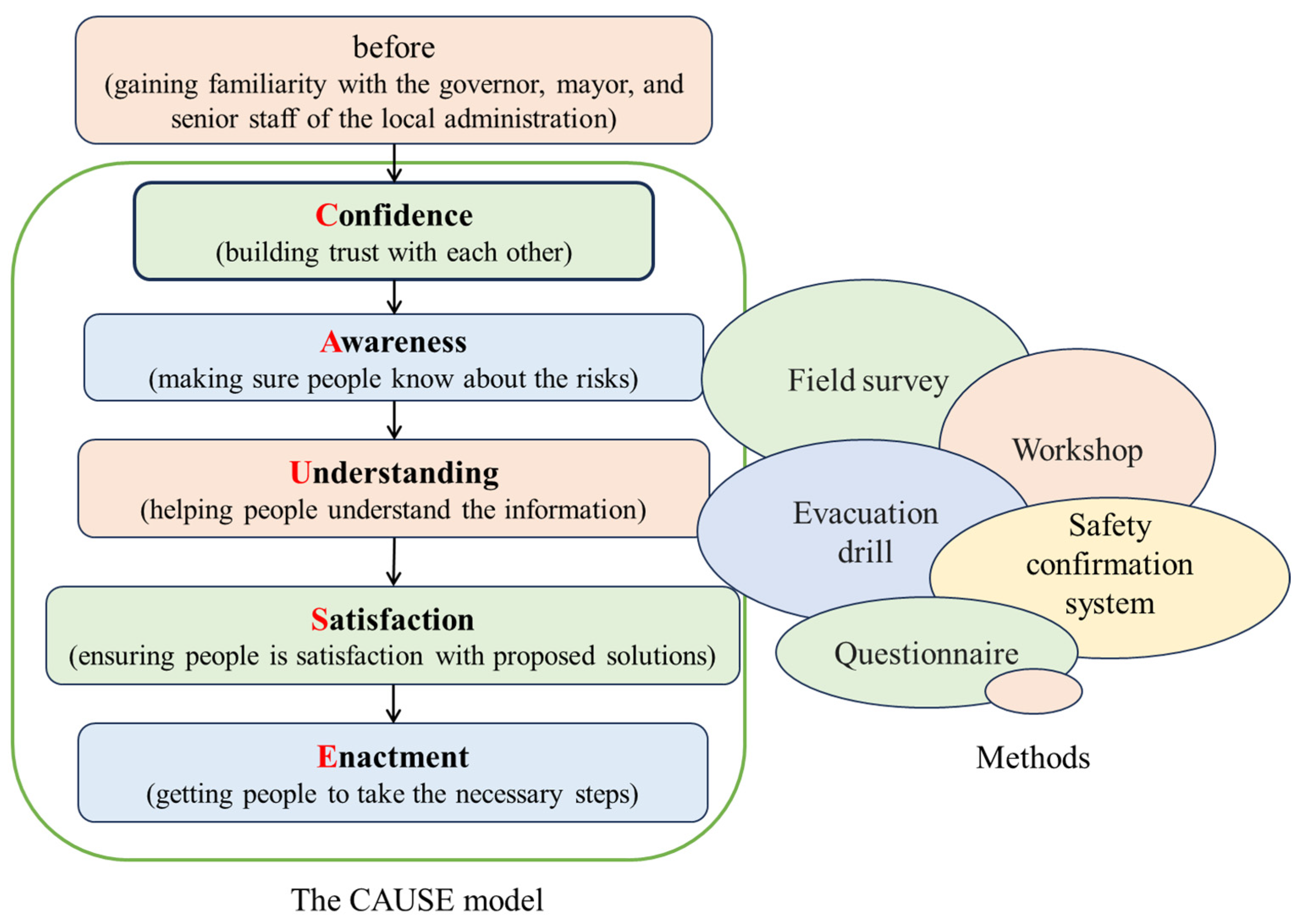
2.1. CAUSE Model
2.2. BECAUSE Model
2.3. Details of Actions in CAUSE Model
3. Results
3.1. Application of the CAUSE Model in Japan
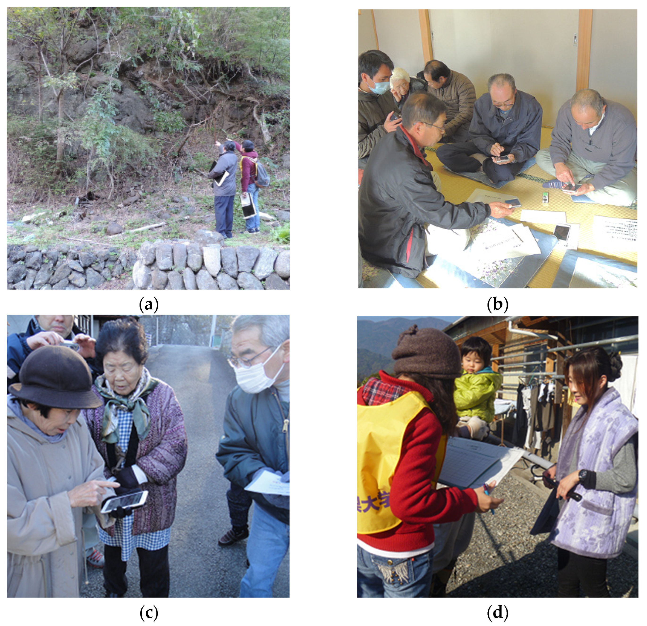
3.1.1. Field Survey
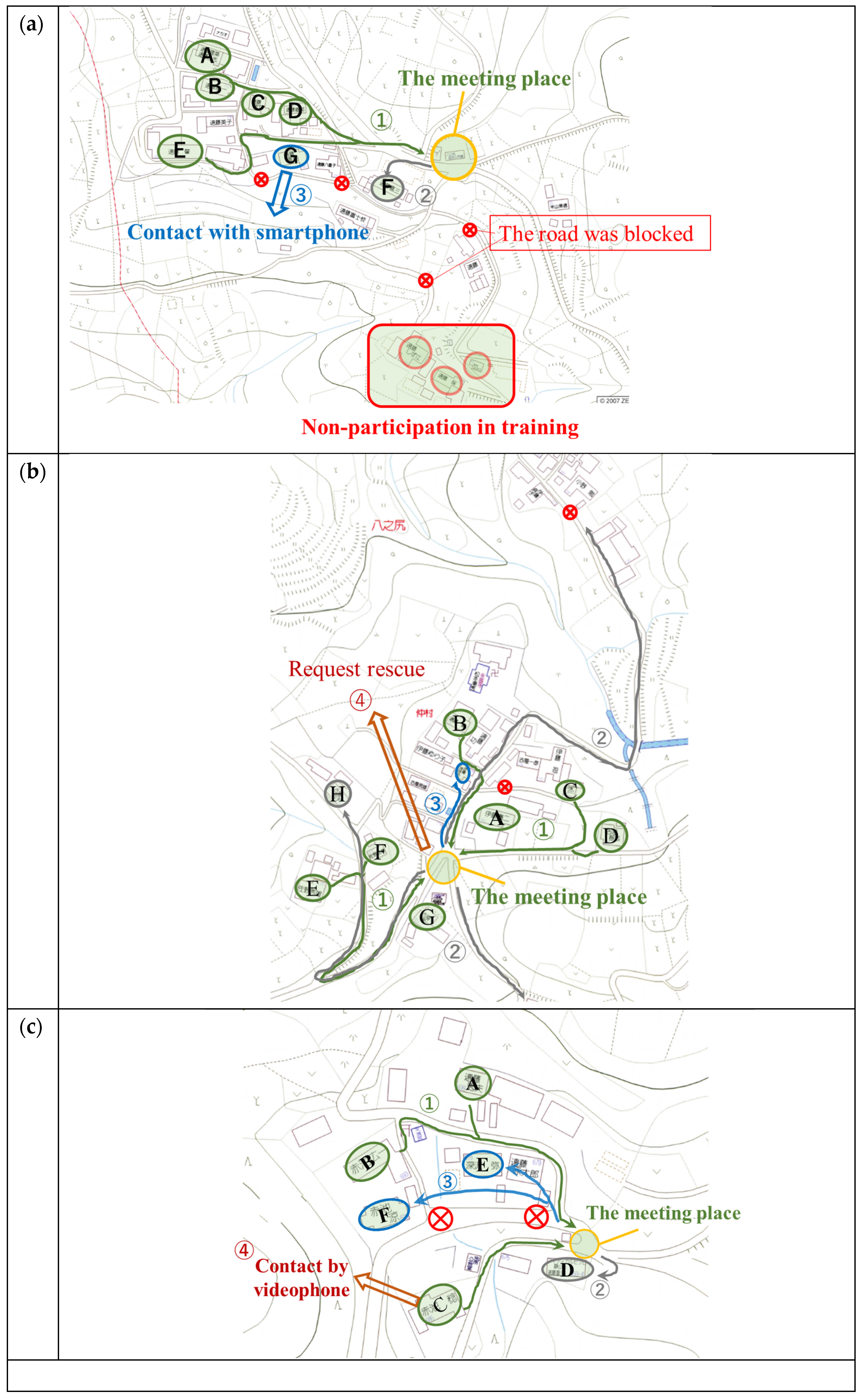
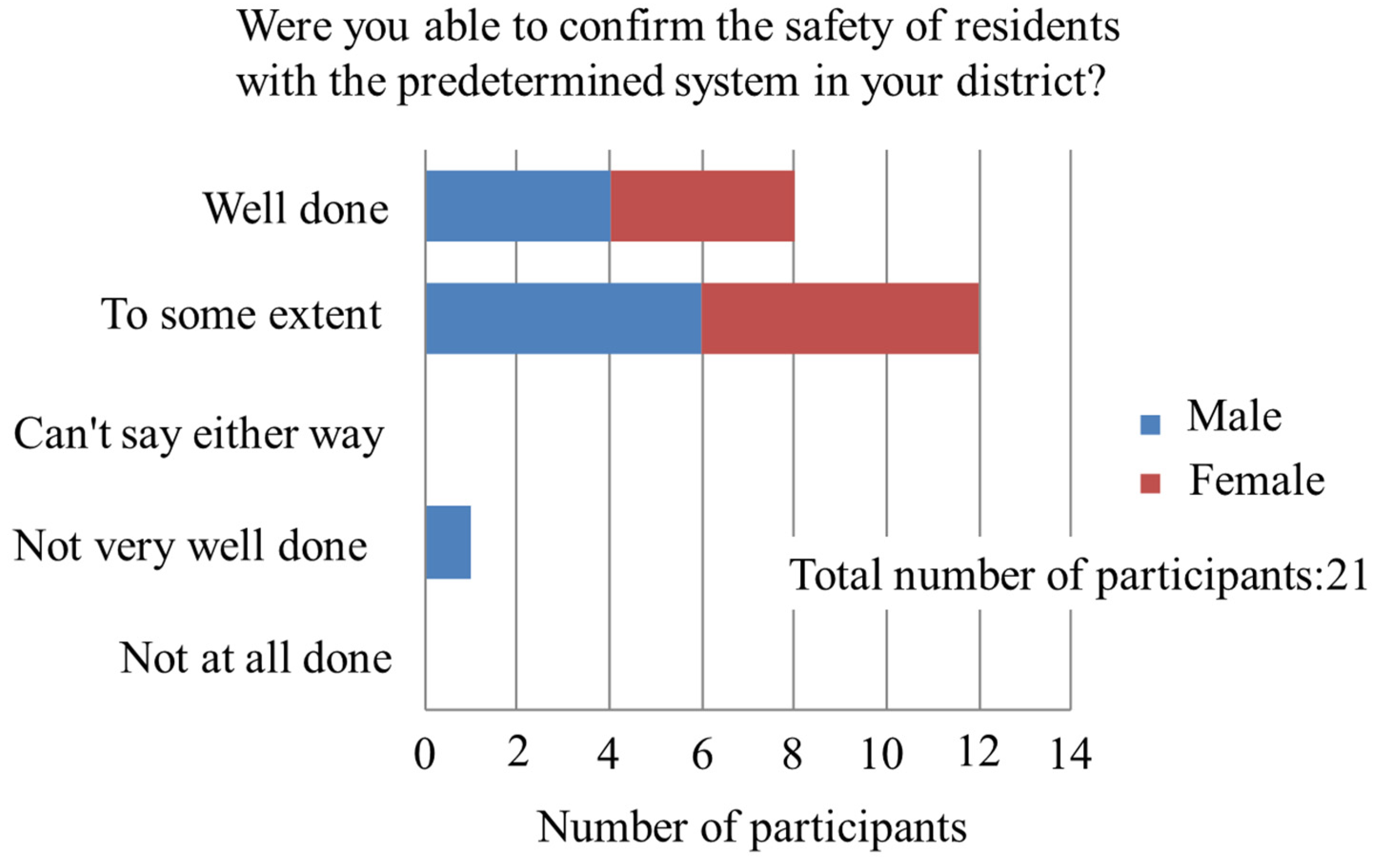
3.1.2. The Relationship Between Isolation and the CAUSE Model
- Agreement formation evaluation
- 2.
- Achievement of A, U, S by a questionnaire
- 3.
- Construction of a safety confirmation system
- 4.
- Securing information transmission means
3.2. Application of the CAUSE Model in China (Five Areas)
3.2.1. Local Geological Field Survey
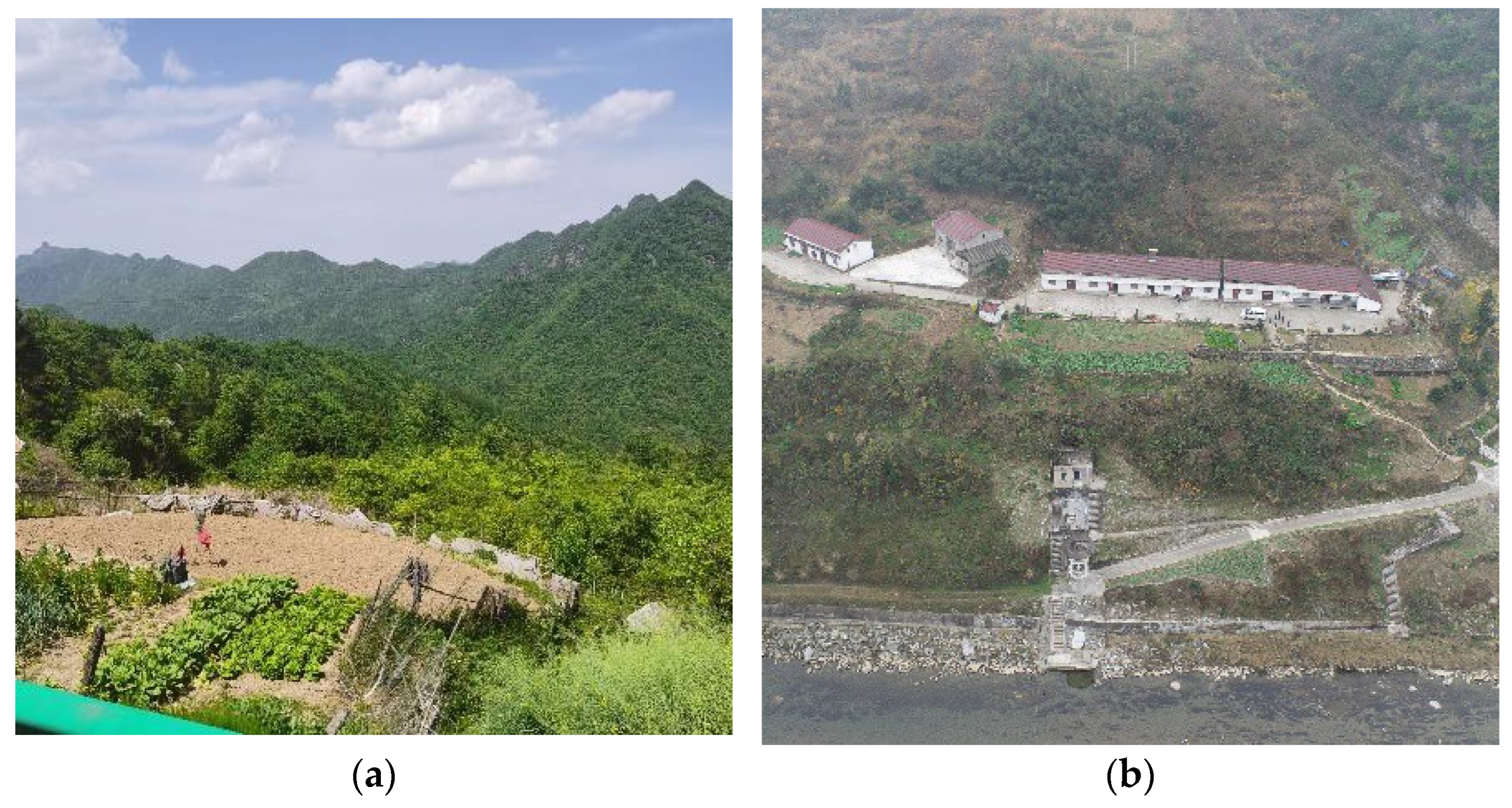
- Site A
- 2.
- Site B
- 3.
- Site C
- 4.
- Site D
- 5.
- Site E
3.2.2. CAUSE Model to Promote Regional Disaster Prevention Measures
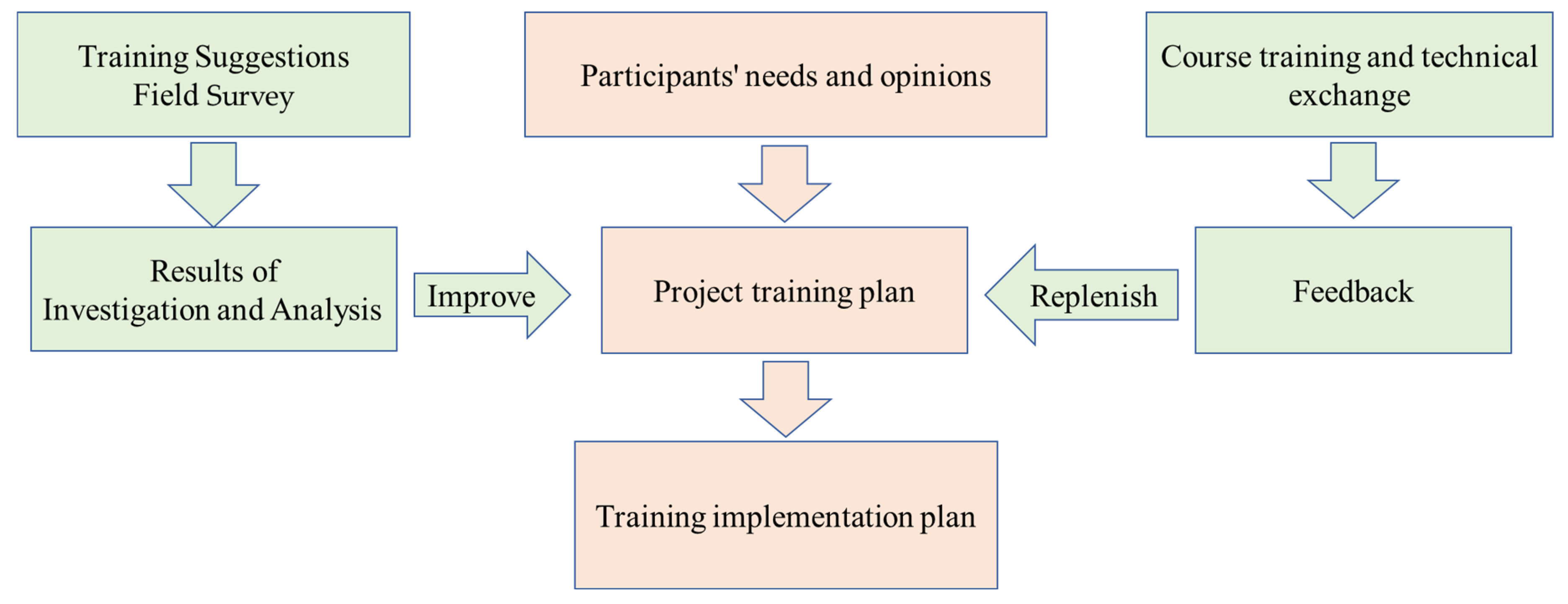
3.2.3. Study Class for Disaster Prevention Responsibilities
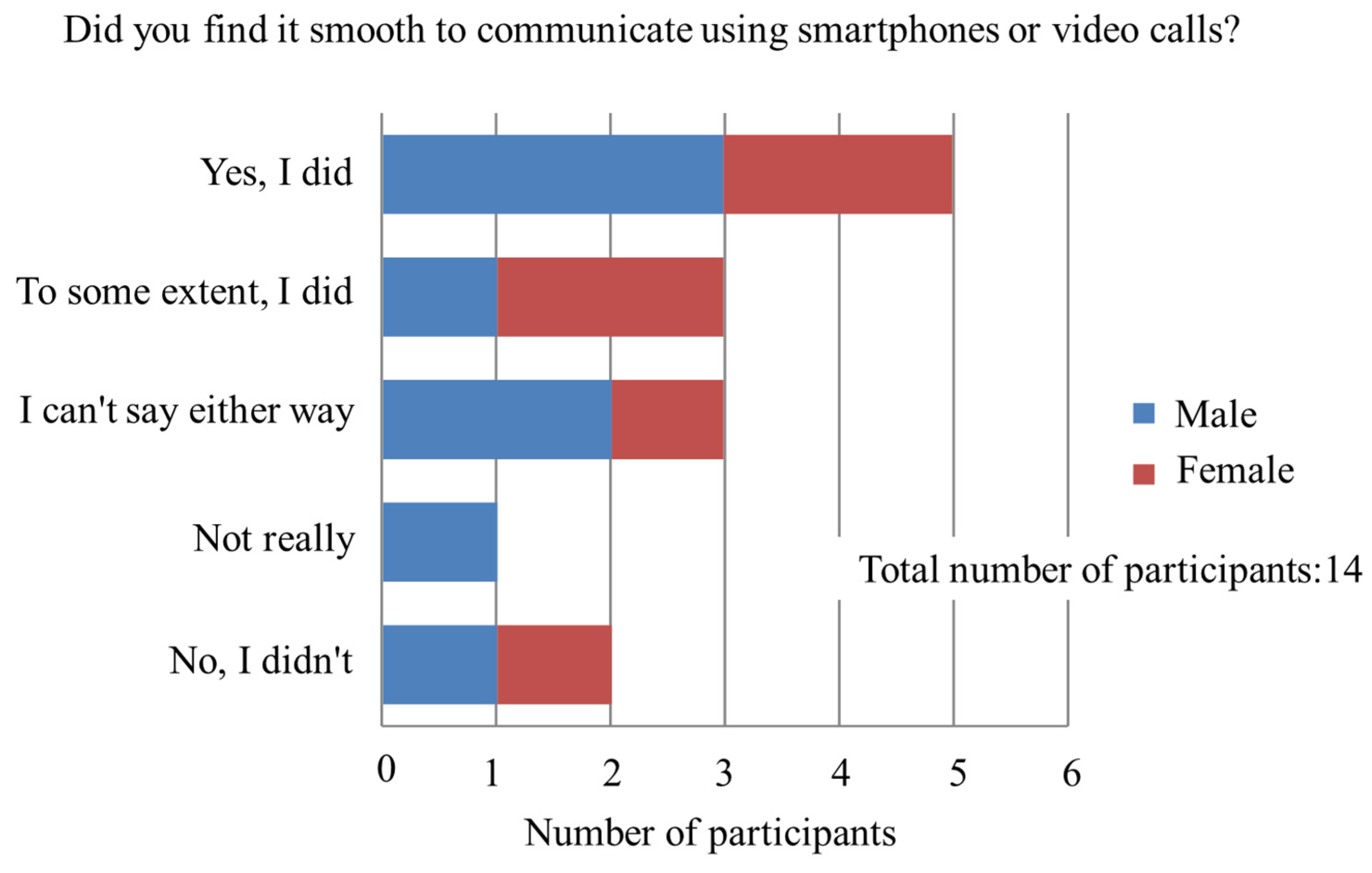
3.2.4. Questionnaire Survey
3.2.5. Evaluation and Feedback from the Training Program
4. Discussion
5. Conclusions
Author Contributions
Funding
Data Availability Statement
Conflicts of Interest
References
- Mirus, B.B.; Jones, E.S.; Baum, R.L.; Godt, J.W.; Slaughter, S.; Crawford, M.M.; Lancaster, J.; Stanley, T.; Kirschbaum, D.B.; Burns, W.J.; et al. Landslides across the USA: Occurrence, Susceptibility, and Data Limitations. Landslides 2020, 17, 2271–2285. [Google Scholar] [CrossRef]
- Cabinet Office Disaster Management in Japan; Director General for Disaster Management, Cabinet Office, Government of Japan. Available online: https://www.bousai.go.jp/1info/pdf/saigaipamphlet_je.pdf (accessed on 1 March 2025).
- Froude, M.J.; Petley, D.N. Global Fatal Landslide Occurrence from 2004 to 2016. Nat. Hazards Earth Syst. Sci. 2018, 18, 2161–2181. [Google Scholar] [CrossRef]
- Terzaghi, K. Mechanism of Landslides. In Application of Geology to Engineering Practice; Geological Society of America: New York, NY, USA, 1950; pp. 83–123. ISBN 9780813759418. [Google Scholar]
- Varnes, D.J. Landslide Types and Processes. Highw. Res. Board Spec. Rep. 1958. Available online: https://onlinepubs.trb.org/Onlinepubs/sr/sr247/sr247-003.pdf (accessed on 1 March 2025).
- Varnes, D.J. Slope Movement Types and Processes. In Landslides, Analysis and Control, Transportation Research Board, Special; National Academy of Sciences: Washington, DC, USA, 1978; pp. 11–33. [Google Scholar]
- Popescu, M.E.; Sasahara, K. Ensgineering Measures for Landslide Disaster Mitigation. In Landslides-Disaster Risk Reduction; Springer: Berlin, Germany, 2009; pp. 609–631. [Google Scholar]
- Hutchinson, J.N. Landslides in Britain and Their Countermeasures. Landslides 1984, 21, 1–25. [Google Scholar] [CrossRef]
- Conte, E.; Troncone, A. A Performance-Based Method for the Design of Drainage Trenches Used to Stabilize Slopes. Eng. Geol. 2018, 239, 158–166. [Google Scholar] [CrossRef]
- Baum, R.L.; Godt, J.W. Early Warning of Rainfall-Induced Shallow Landslides and Debris Flows in the USA. Landslides 2010, 7, 259–272. [Google Scholar] [CrossRef]
- Peruccacci, S.; Brunetti, M.T.; Gariano, S.L.; Melillo, M.; Rossi, M.; Guzzetti, F. Rainfall Thresholds for Possible Landslide Occurrence in Italy. Geomorphology 2017, 290, 39–57. [Google Scholar] [CrossRef]
- Naidu, S.; Sajinkumar, K.S.; Oommen, T.; Anuja, V.J.; Samuel, R.A.; Muraleedharan, C. Early Warning System for Shallow Landslides Using Rainfall Threshold and Slope Stability Analysis. Geosci. Front. 2018, 9, 1871–1882. [Google Scholar] [CrossRef]
- Uchimura, T.; Towhata, I.; Wang, L.; Nishie, S.; Yamaguchi, H.; Seko, I.; Qiao, J. Precaution and Early Warning of Surface Failure of Slopes Using Tilt Sensors. Soils Found. 2015, 55, 1086–1099. [Google Scholar] [CrossRef]
- Tao, S.; Uchimura, T.; Fukuhara, M.; Tang, J.; Chen, Y.; Huang, D. Evaluation of Soil Moisture and Shear Deformation Based on Compression Wave Velocities in a Shallow Slope Surface Layer. Sensors 2019, 19, 3406. [Google Scholar] [CrossRef] [PubMed]
- Hu, D.; Pai, J.-T.; Chen, Y.-Y. A Study of Flood Disaster Risk Communication Model and Adaptive Behaviours for River-Watershed Residents in Taiwan. Int. Rev. Spat. Plan. Sustain. Dev. 2018, 6, 128–147. [Google Scholar] [CrossRef] [PubMed]
- Chandra, Y.A.; Kawamura, Y.; Paudel, S.; Nishigawa, M. Value of Mutual Assistance for Disaster Risk Reduction in Japan, Indonesia, and Nepal: A Preliminary Study. Health Emerg. Disaster Nurs. 2020, 7, 9–16. [Google Scholar] [CrossRef]
- Rowan, K.E. Why Rules for Risk Communication Are Not Enough: A Problem-Solving Approach to Risk Communication. Risk Anal. 1994, 14, 365–374. [Google Scholar] [CrossRef]
- Rowan, K.E.; Botan, C.H.; Kreps, G.L.; Samoilenko, S.; Farnsworth, K. Risk Communication Education for Local Emergency Managers: Using the CAUSE Model for Research, Education, and Outreach. In Handbook of Risk and Crisis Communication; Routledge: London, UK, 2010; pp. 168–191. [Google Scholar]
- Suzuki, T.; Watanabe, T.; Okuyama, S. Facilitating Community Risk Communication for Wide-Area Evacuation during Large-Scale Floods. Int. J. Environ. Res. Public Health 2019, 16, 2466. [Google Scholar] [CrossRef] [PubMed]
- Suzuki, T.; Miyamoto, T.; Hada, Y. Application of the BECAUSE Model to Establishment of a Collaboration System with Relevant Administrative Agencies for Regional Evacuation Due to Large River Flooding. J. Disaster Inf. Stud. 2016, 14, 105–115. [Google Scholar] [CrossRef]
- Suzuki, T. Risk Communication in Order to Facilitate Community Resilience against a Large-Scale Flood. WIT Trans. Built Environ. 2019, 190, 145–155. [Google Scholar] [CrossRef]
- Uchida, T.; Nishimoto, H.; Osanai, N.; Shimizu, T. Countermeasures for Sediment-Related Disasters in Japan Using Hazard Maps. Int. J. Eros. Control Eng. 2009, 2, 46–53. [Google Scholar] [CrossRef]


| Stage | Actions | Purpose |
|---|---|---|
| Before | Meeting | Gaining familiarity with the governor, mayor, and senior staff of the local administration. |
| Confidence | Workshop Introduction | Building a relationship of mutual trust with each other. |
| Awareness | Field survey Workshop | Finding out the risk of the surrounding geological environment. Extracting measures for the isolation of mountain villages. |
| Understanding | Workshop Questionnaire | Letting the residents know that they can help each other or ask for mutual assistance by using the safety confirmation system. |
| Solution | Training Questionnaire | Becoming skilled in using safety confirmation systems. Becoming proficient in using information and messaging on SNS platforms. Gaining the ability to confirm their safety with each other. Becoming experienced in requesting support from government offices. |
| Enactment | Evacuation drill Reflection meeting Questionnaire | Implementation and feasible solutions to sediment disasters. |
| No | Geological Characteristics | Disaster Subject | Countermeasure |
|---|---|---|---|
| Site A | There is a thick accumulation of gravel and soil on the slope, and the surface water mainly comes from rainfall. During the investigation, water was found to be flowing out, indicating that the groundwater was abundant. The retaining wall at the front edge was damaged, the rear edge had obvious cracks, and the trees at the rear edge were crooked. | 5 households; highway | Meteorological observation; Channel runoff observation; Flood level observation; Soil moisture observation; Groundwater level observation; Slope deformation observation. |
| Site B | The slope is primarily composed of weathered rock and gravelly soil. The area is flanked by gullies with streams flowing through it, featuring lush vegetation and extensive farmland, with an overall gentle gradient. Current signs of potential landslides include displacement cracks on the roads within the investigation area, cracked houses along the roadside that are nearly collapsing, displaced drainage pipes behind the walls of nearby residential buildings, and tension cracks in houses on the hillside. Based on these indicators, it can be concluded that the area is highly likely to experience a landslide disaster under heavy rainfall conditions. | 8 households; highway | Meteorological observation; Channel runoff observation; Flood level observation; Soil moisture observation; Groundwater level observation; Slope deformation observation. |
| Site C | The area is a scenic spot and, according to residents, rainfall frequently triggers rockfall events. Investigations revealed that the slope structure is incomplete, with tensile cracks aligned with the slope’s inclination. If a rock collapse occurs, it could disrupt road traffic, severely impacting transportation. | highway | Meteorological observation; Rockfall observation. |
| Site D | This area consists of an ancient landslide deposit composed of soil and rock, with a structurally deformed slope. The vegetation is predominantly artificially planted peach trees. The region has a large catchment area, with the valley surrounded by mountains on three sides and a narrow outlet, giving it an overall leaf-like planar shape. | 5 households; highway | Meteorological observation; Channel runoff observation; Flood level observation; Soil moisture observation; Groundwater level observation; Slope deformation observation. |
| Site E | The area features high mountainous terrain with a large catchment area. The gullies are narrow, elongated, and steeply sloped, containing two main streams that flow year-round. The gully outlets are drained through culverts. | 5 households; highway | Meteorological observation; Channel runoff observation; Flood level observation; Soil moisture observation; Groundwater level observation; Slope deformation observation. |
| Evaluation Items | Site A | Site B | Site C | Site D | Site E |
|---|---|---|---|---|---|
| (1) Slopes with no exposed base rock and collapsible surface soil | △ | ◎ | - | ◎ | ◎ |
| (2) Evidence of past collapse or cracks | - | ◎ | - | 〇 | - |
| (3) Relatively tight slope | ◎ | ◎ | ◎ | ◎ | 〇 |
| (4) Possibility of collapsed sediment reaching houses, etc. | 〇 | ◎ | △ | ◎ | ◎ |
| (5) Facing a public building | ◎ | - | - | - | ◎ |
| (6) The degree of damage is assumed to be above a certain scale | ○ | ◎ | △ | ◎ | ◎ |
| No | Contents | Excellent | Good | Acceptable |
|---|---|---|---|---|
| 1 | Integrated watershed management (09:45–11:45, day 1) | |||
| 2 | The water hazard alleviation in Site 1 (14:30–16:30, day 1) | |||
| 3 | Practice and strategies of mountain torrent disaster prevention (09:00–11:00, day 2) | |||
| 4 | Non-engineering prevention measures of mountain torrent disasters in Site 2 (14:30–16:30, day 2) | |||
| 5 | Establishment and effectiveness of the non-engineering defense system for mountain torrent disasters in Site 3 (09:00–11:00, day 3) | |||
| 6 | Progress of national quantitative precipitation forecast (14:30–16:30, day 3) | |||
| 7 | Water resources cooperation in Site 4 (09:00–10:00, day 4) | |||
| 8 | Mountain torrent disaster prevention in Site 5 (10:00–11:00, day 4) | |||
| 9 | River Flood Protection Moder in Site 6 (08:30–11:30; day 5) | |||
| 10 | Changjiang Civilization Museum (14:00–16:30; day 5) | |||
| 11 | On-site Visit: Three Gorges Dam (14:00–17:30, day 6) | |||
| 12 | On-site Visit: Jinsha Site Museum (09:00–12:00 day 7) | |||
| 13 | On-site Visit: Flood Control Projects in Site1 (13:30–16:30, day 7) | |||
| 14 | On-site Visit: Water Conservancy Project in site 4 (09:00–16:30, day 8) |
Disclaimer/Publisher’s Note: The statements, opinions and data contained in all publications are solely those of the individual author(s) and contributor(s) and not of MDPI and/or the editor(s). MDPI and/or the editor(s) disclaim responsibility for any injury to people or property resulting from any ideas, methods, instructions or products referred to in the content. |
© 2025 by the authors. Licensee MDPI, Basel, Switzerland. This article is an open access article distributed under the terms and conditions of the Creative Commons Attribution (CC BY) license (https://creativecommons.org/licenses/by/4.0/).
Share and Cite
Tang, Z.; Suzuki, T.; Tao, S.; Dong, L.; Fan, Z. Analysis and Application of the CAUSE Model in Regional Disaster Prevention Measures. GeoHazards 2025, 6, 17. https://doi.org/10.3390/geohazards6020017
Tang Z, Suzuki T, Tao S, Dong L, Fan Z. Analysis and Application of the CAUSE Model in Regional Disaster Prevention Measures. GeoHazards. 2025; 6(2):17. https://doi.org/10.3390/geohazards6020017
Chicago/Turabian StyleTang, Zhijun, Takeyasu Suzuki, Shangning Tao, Linyao Dong, and Zhongjie Fan. 2025. "Analysis and Application of the CAUSE Model in Regional Disaster Prevention Measures" GeoHazards 6, no. 2: 17. https://doi.org/10.3390/geohazards6020017
APA StyleTang, Z., Suzuki, T., Tao, S., Dong, L., & Fan, Z. (2025). Analysis and Application of the CAUSE Model in Regional Disaster Prevention Measures. GeoHazards, 6(2), 17. https://doi.org/10.3390/geohazards6020017