Abstract
To reduce the significant losses caused by slope failures and landslides, it is of great significance to detect and predict these disasters scientifically. This study focused on Huangdao District of Qingdao City in Shandong Province, using the improved Faster R-CNN network to detect slope failures and landslides. This study introduced a multi-scale feature enhancement module into the Faster R-CNN model. The module enhances the network’s perception of different scales of slope failures and landslides by deeply fusing high-resolution weak semantic features with low-resolution strong semantic features. Our experiments show that the improved Faster R-CNN model outperformed the traditional version, and that ResNet50 performed better than VGG16 with an AP value of 90.68%, F1 value of 0.94, recall value of 90.68%, and precision value of 98.17%. While the targets predicted by VGG16 were more dispersed and the false detection rate was higher than that of ResNet50, VGG16 was shown to have an advantage in predicting small-scale slope failures and landslides. The trained Faster R-CNN network model detected geological hazards of slope failure and landslide in Huangdao District, missing only two landslides, thereby demonstrating high detection accuracy. This method can provide an effective technical means for slope failures and landslides target detection and has practical implications.
1. Introduction
Slope failures and landslides are recurring and devastating geological disasters that result in substantial economic losses globally and pose a severe threat to people’s safety [1,2]. Therefore, it is vital to precisely detect and predict the location and damage range of these disasters. Geographical location and morphological attributes of slope failure and landslide are monitored through remote sensing image detection, which can be classified into two types: traditional detection methods [3,4,5,6,7] and deep learning detection methods [8,9,10,11]. The traditional detection method utilizes prior knowledge of artificially designed slope failures and landslides combined with image processing technology. Ohnishi et al. [12] used digital images to measure slope displacement and achieve slope monitoring; however, this method requires expert knowledge. In recent years, deep learning technology has made breakthroughs, and deep Convolutional Neural Networks (CNNs) have gradually been applied to high-resolution remote sensing image classification [13,14,15,16], semantic segmentation [17,18,19], target detection [20,21,22,23], and so on. Therefore, the development of deep learning-based techniques for detecting slope failure and landslide is gradually emerging.
The task of detecting slope failure and landslide using deep learning can be divided into one-stage and two-stage target detection algorithms. In the one-stage detection algorithm, classic frameworks include YOLO series and SSD algorithm. The first-generation YOLO algorithm based on overfeat was proposed in 2015 and became the leading algorithm due to its speed advantage. However, this algorithm is prone to miss detections. In 2016, SSD improved the positioning problem of YOLO, and Joseph proposed YOLOv2 and YOLO9000. YOLOv3 in 2018 changed the single label category to a multi-label category and combined multi-scale feature mapping to improve prediction accuracy [24]. YOLOv4 and YOLOv5 appeared in 2020, with YOLOv4 having good accuracy, but still having some missing detection [25,26], and YOLOv5 having a more flexible network structure. Two-stage target detection algorithms encompass a range of methods, including R-CNN, SPP-Net, Fast R-CNN, and Faster R-CNN. Among them, R-CNN is considered a classic algorithm [27]. R-CNN selects candidate frames of regions of interest in images of slope failure and landslide as input for CNNs [28]. The overall accuracy of R-CNN is 50% higher than existing algorithms, but its calculation speed is slow. The SPP-Net algorithm solves the problem of repeated CNN operations by using the pool of spatial pyramids to control the consistency of candidate frame size, thus saving calculation costs [29]. However, both SPP-Net and R-CNN have inconsistent image sizes of slope failure and landslide after training, leading to problems updating weights using the backpropagation algorithm and slowing speed [30]. Fast R-CNN adopts ROI pooling structure to solve this issue, but still uses the selective search algorithm for candidate frame calculations, leading to slow calculation speeds. Faster R-CNN utilizes the RPN algorithm to address this issue, which involves two key components. Firstly, the RPN identifies potential regions of interest in the landslide images. Subsequently, it classifies the identified regions to determine the types of slope failures and landslides. This approach prevents a decrease in accuracy caused by an overly extensive extraction of candidate areas [31].
Among the above methods, the one-stage detection algorithm achieves end-to-end transmission, having faster detection speeds than the two-stage detection algorithm. However, its regression algorithm causes the one-stage detection model to miss some detections, while the two-stage detection algorithm excels in detection accuracy. The practical application of target detection algorithms in engineering can significantly improve detection efficiency and provide timely warnings for slope failure and landslide risks, thereby enhancing the overall security of practical engineering projects. Although the two-stage Faster R-CNN algorithm boasts high detection accuracy, its complexity poses challenges to its practical implementation. Consequently, there have been limited studies on the utilization of this network for landslide identification. To achieve more precise identification of slope failure and landslide disasters in high-resolution remote sensing images, this paper proposes a novel multi-scale feature enhancement module based on the traditional Faster R-CNN framework. This module effectively integrates high-resolution weak semantic features with low-resolution strong semantic features, thereby augmenting the overall perception capability of the Faster R-CNN network for slope failures and landslides of varying scales. Furthermore, this paper conducts a comparative analysis among the widely used traditional Faster R-CNN, YOLOv5, and SSD target detection algorithms. By comparing and analyzing the experimental results, more effective detection results of slope failure and landslide disasters can be obtained.
2. Materials and Methods
2.1. Study Area
Huangdao District, also known as Qingdao West Coast New District, is a municipal district of Qingdao, Shandong Province, with a total area of about 2128 km2. Huangdao District is considered China’s ninth national new district and a national land and sea comprehensive development experimental zone. The district is situated in the southwestern corner of the Shandong Peninsula and borders the Jiaozhou Bay, ranging from 35°35′ to 36°08′ N and 119°30′ to 120°11′ E, with a diagonal length of 79.25 km from northeast to southwest and a width of 62.36 km from east to west. Huangdao District features a hilly terrain in eastern Shandong, characterized by undulating mountains and ravines. The Pearl Mountains are located to the west, with the highest peak reaching 724.9 m above sea level. Meanwhile, Laojun Mountain, Longque Mountain, and Qiangma Mountain are situated to the north. The eastern part of the district borders the sea and features a curved coastline with numerous islands. Xuejia Island is located in the southeast, separating Jiaozhou Bay from the Yellow Sea. The middle section comprises a marine plain, and the overall terrain is high in the west and low in the east.
According to the report on geological disaster investigation results of the national comprehensive risk survey of natural disasters in Huangdao District, Qingdao, Shandong Province, there are 31 natural slope failure and di in the region. Figure 1 illustrates the distribution of slope failure and landslide points in the area.
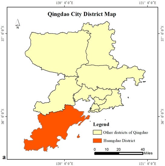
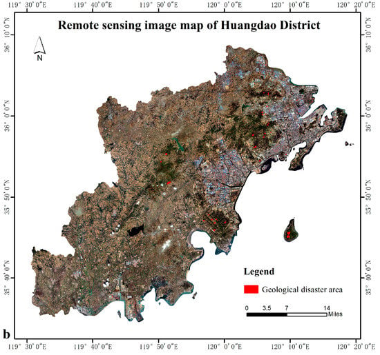
Figure 1.
Distribution map of slope failure and landslide in the study area: (a) the administrative boundary map of each district in Qingdao and the location of Huangdao District in Qingdao; (b) location map of slope failure and landslide disaster in Huangdao District.
2.2. Methods
The application of deep learning in detecting slope failure and landslide aims to address the issue of locating these disasters in images. Optically sensing and detecting slope failures and landslides involves determining if an image contains one or multiple targets while precisely locating each predicted target. Figure 2 showcases the improved Faster R-CNN network structure employed in this study, composed of five primary components: backbone feature extraction network, multi-scale feature enhancement module, candidate region extraction, region of interest pooling, and classification and regression prediction.
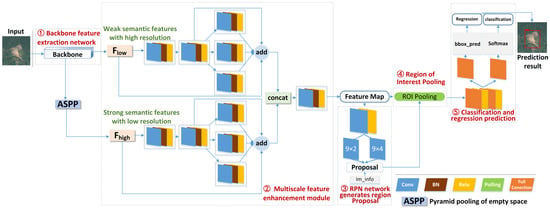
Figure 2.
Improved Faster R-CNN target detection network structure.
2.2.1. Backbone Feature Extraction Network
The backbone feature extraction network of Faster R-CNN is composed of a group of fundamental convolution layers, ReLU, and pooling layers designed to extract slope failure and landslide features in images. The Faster R-CNN backbone feature extraction network aims to capture both high-resolution weak semantic features and low-resolution strong semantic features from input images. It has the capability to leverage multiple backbone feature extraction networks, such as VGG and ResNet, to achieve this goal. This study mainly employs VGG16 and ResNet50 as backbone feature extraction networks.
- Backbone feature extraction network based on VGG16.
VGG Net is a model proposed by the Visual Geometry Group of Oxford University. Its significant contribution is demonstrating that an increase in network depth can improve performance by utilizing very small convolutions. The VGGNet model comprises five structural networks labeled as A through E, with VGG16 and VGG19 being the typical network structures. Figure 3a showcases the network structure of VGG16 utilized by Faster R-CNN in this study. The VGG16 network structure comprises 13 layers, including parameter network layers consisting of an input module, an output module, and five module layers, with the five module layers combining convolutional and pooling layers.
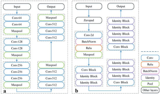
Figure 3.
Backbone network structure diagram: (a) VGG16; (b) ResNet50.
- 2.
- Backbone feature extraction network based on ResNet50.
ResNet (Residual Neural Network) was proposed by He Kaiming and others at Microsoft Research Institute and successfully trained 152 layers of deep neural network using residual units [29]. ResNet is an improvement on the VGG19 network that utilizes short circuit mechanisms to add residual units. Despite having more layers than VGG19, ResNet uses fewer parameters, reducing false detection rates and significantly improving detection accuracy. The network structure of ResNet50 adopted in this study is shown in Figure 3b and enables faster neural network training speeds and improved model accuracy. ResNet50 consists of two basic blocks, the Conv Block and Identity Block, which can be seen on the structural diagram of Faster R-CNN. The Conv Block’s input and output dimensions differ, preventing the residual edge from being continuously connected in series due to convolution. Its function is to alter the network’s dimensions, as shown in Figure 4a. Conversely, the Identity Block has equal input and output dimensions, and the residual edge does not include any convolutions, enabling the network to be deepened through series connection, as shown in Figure 4b. Both blocks utilize the residual network structure.
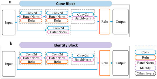
Figure 4.
Basic residual network structure of ResNet50: (a) Conv Block; (b) Identity Block.
2.2.2. Multi-Scale Feature Enhancement Module
To further enhance the network’s capability of extracting features of different scale landslides and slope failures, this paper presents a multi-scale feature enhancement module. The module augments the network’s ability to perceive slope failures and landslides at varying scales by deeply fusing high-resolution weak semantic features and low-resolution strong semantic features. The high-resolution weak semantic features refer to shallow slope failure and landslide features obtained from the backbone feature extraction network, while the low-resolution strong semantic features are derived from both the backbone feature extraction network and the hollow space pyramid pool, capturing deep slope failure and landslide features.
The multi-scale feature enhancement module is mainly composed of three parallel composite convolution blocks based on the residual module. Each block includes a convolution layer, BN layer, and ReLu. The three parallel composite convolution blocks have different convolution kernel sizes of 3 × 3, 5 × 5, and 7 × 7, respectively. These convolution kernel sizes extract the slope failure and landslide features of varying scales. The module employs three branches to extract features of varying scales. It utilizes both high-resolution weak semantic features and low-resolution strong semantic features. These features are then merged through parallel connections and composite convolution blocks. The result is a shared feature layer consisting of high-resolution strong semantic features.
2.2.3. Candidate Region Extraction
RPN (Region Proposal Networks) is a regional candidate network and the core component of the algorithm. It is constructed using a full convolutional network and can directly generate detection frames, significantly improving the algorithm’s speed and quickly detecting candidate regions of frames [30]. The output feature map of CNN is the feature map input by RPN, and the shared feature layer has two applications, where one is combined with ROI Pooling, and the other is a convolution of 9 × 2 channels and a convolution of 9×4 channels, which are used to judge the change of each prior frame and whether each prediction frame contains objects. In order to screen redundant candidate frames, non-maximum suppression is introduced. First, the object with the highest score is found, and then the IoU values of this object and other objects are calculated, and all the objects larger than the set threshold are deleted.
2.2.4. Pooling of Areas of Interest
The region of interest pooling layer can accelerate training and improve testing speed and accuracy. The effective ROI output from the RPN layer and the output from the shared feature layer are the inputs of the region of interest pooling layer. The effective ROI is mapped to the corresponding feature layer region, and the classification of the corresponding feature layer location range is used to divide the output blocks into the same number and size. Finally, the feature map with the same size can be obtained from blocks with different sizes by the operation of maximum pooling.
2.2.5. Classification and Regression Prediction
After obtaining the fixed-sized feature map through the ROI pooling technique, the feature map is passed to the subsequent network to filter the candidate boxes after non-maximum suppression. Then, the network primarily conducts classification and regression prediction. Classification prediction computes the specific category of each candidate box using the obtained feature map through the fully connected layer and softmax. Meanwhile, regression prediction determines the position offset of each candidate frame and generates a more accurate prediction frame, that is, the boundary frame with the highest score, through the boundary frame regressor.
2.2.6. Evaluation Indicators
In this study, various indices were employed to assess the experiment’s accuracy, including Intersection-over-Union (IoU), Average Precision (AP), F1 score (F1), recall rate, and precision.
IoU measures the overlap between the predicted candidate frames and manually marked candidate frames, represented as the ratio of their intersection and union. The formula is shown in Equation (1).
where S1 represents the area of the prediction frame, S2 represents the area of the actual marker frame, S1∩S2 represents the intersection area of the prediction frame and the real frame, and S1∪S2 represents the union area of the prediction frame and the real frame. According to the IoU formula, its value range is 0~1. This value was set to 0.5 in this experiment.
AP is the integral of the PR curve drawn by the accuracy and recall, which represents the overall classification ability of the model, and its formula is shown in Equation (2).
Recall reflects the ability of the model to find positive samples, and its calculation formula is shown in Equation (3).
where FP represents the number of negative samples wrongly identified as positive samples, TP represents the number of positive samples correctly identified, and FN represents the number of positive samples wrongly identified as negative samples.
Precision refers to the proportion of actual positive samples in the predicted positive samples, which reflects the classification ability of the model for positive samples, as shown in Equation (4).
It is a comprehensive evaluation of recall and accuracy. In the case of higher accuracy and recall, the higher the value, the higher the accuracy of the detection result, as shown in Equation (5).
3. Results
3.1. Experimental Data Set Creation
This study utilized orthographic remote sensing images of Huangdao District with a resolution of 1 m. To generate the dataset, the remote sensing image was cropped to 300 × 300 pixels, with an overlapping area of 100 × 100 pixels. Due to the different areas and shapes of slope failures and landslides in Huangdao District, the hazards must be located in the central area of the image while preserving a certain area surrounding them to form an enclosing rectangle. This makes it easier for the target detection network to extract geological hazards. As depicted in the training sample of Figure 5, the red box indicates the range of slope failures and landslides, and the blue box represents the outermost boundary of slope failures and landslides. Given the scarcity of slope failure and landslide points within the study area, the samples were enhanced to prevent over-fitting. These enhancements entail random scaling; aspect ratio alteration; and hue, saturation, and lightness adjustment. Following data enhancement, 1500 samples were obtained and classified into training samples, validation samples, and test samples in the ratio of 6:2:2.
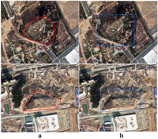
Figure 5.
Training sample preparation: (a) the scope of slope failure and landslide points is marked in red on the map; (b) the range of the label is indicated in blue on the diagram.
3.2. Experimental Configuration
All experiments in this study were based on Windows10 system, which is configured with Intel (R) Core (TM) i5-10400 @ 2.90 GHz CPU and Nvidia GeForce GTX3090 GPU. The Pytorch deep learning network framework was employed to implement the network model in this study. The batch size was set at 2, the number of training rounds was set at 200, and the learning rate was 0.0001. The optimizer was Adam, a stochastic optimization method with adaptive momentum.
3.3. Model Evaluation Results
To validate the improved Faster R-CNN model’s efficacy in detecting slope failure and landslide targets, comparative experiments were conducted with YOLOv5, SSD, and traditional Faster R-CNN algorithms. YOLOv5 and SSD are representative models of the one-stage algorithm. Table 1 illustrates the accuracy of different algorithm models in detecting slope failure and landslide in Huangdao District.

Table 1.
Slope failure and landslide detection accuracy of different networks.
Table 1 demonstrates that the improved Faster R-CNN network has enhanced AP, F1, recall rate, and precision when compared to YOLOv5, SSD, and traditional Faster R-CNN networks. The improved Faster R-CNN model was applied to slope failure and landslide points in Huangdao District. For the VGG16 backbone network, the AP value was 88.04%, the F1 value was 0.92, the recall rate was 88.98%, and the precision rate was 94.59%. For the ResNet50 backbone network, the AP value was 90.68%, the F1 value was 0.94, the recall rate was 90.68%, and the precision rate was 98.17%, indicating that it had the most accurate model result in the experiment.
YOLOv5, SSD, and traditional Faster R-CNN networks exhibit different limitations. Firstly, with regards to YOLOv5, its AP and precision were impressive at 88.26% and 92.34%, respectively. However, it performed relatively poorer in terms of F1 score and recall rate compared to other models. In particular, the recall rate of YOLOv5 was only 82.48%, indicating that it predicts a smaller number of actual landslides correctly. The recall rate, in turn, influences the F1 score. Compared with other models, the overall accuracy of the SSD algorithm was found to be lower, which shows that this model has poor detection effect on the experimental samples in this study. Conversely, the traditional Faster R-CNN network surpassed both YOLOv5 and the SSD algorithm in terms of precision, but still fell short in terms of AP, F1, recall, and precision when compared to the improved Faster R-CNN network.
In conclusion, the Faster R-CNN model with a multi-scale enhancement module exhibited better detection and identification precision of hidden slope failure and landslide hazards than the traditional Faster R-CNN network.
3.4. Detection Results of Slope Failure and Landslide in Huangdao
The improved Faster R-CNN network was applied to the slope failure and landslide points in Huangdao District for an application demonstration in the geological disaster target detection area. In order to display the model’s effect more intuitively, the image of Huangdao District was cropped to a size of 300 × 300 pixels. An overlapping degree of 100 × 100 pixels was utilized to prevent the network from encountering recognition obstacles due to the incomplete slope failure and landslide points in the cropped image. After cropping, all images were input into the improved Faster R-CNN network for prediction, then the prediction results were spliced, and the scope was restored to Huangdao District. As the ResNet50 model exhibited better prediction outcomes, the target detection of slope failure and landslide geological disasters in Huangdao District was predicted with ResNet50. Figure 6 displays the detection results of slope failures and landslides in Huangdao District. The red boxes represent the correctly detected slope failures and landslides, while the purple boxes indicate missed detection results. The results demonstrate that the model has a high detection accuracy for slope failures and landslide geological disasters. Most of the slope failures and landslides are correctly identified, with only two points remaining undetected.
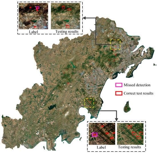
Figure 6.
Application results of the target detection network in Huangdao District.
4. Discussion
4.1. Comparison of Experimental Results between VGG-16 and ResNet50
We further explored the changes in F1, recall rate, and precision values under different confidence levels for the improved Faster R-CNN network, as shown in Figure 7. It can be observed that the F1 and recall of VGG16 and ResNet50 displayed similar trends when the confidence level was between 0.5 and 1. Both of them exhibited a steady decline initially, with a sharp drop when the confidence level was close to 1. Furthermore, when the confidence level was between 0.5 and 1, the F1 and recall values of ResNet50 were marginally higher than those of VGG16. Regarding precision value, both ResNet50 and VGG16 showed gradual increases when the confidence level was between 0.5 and 1, with both of them reaching 100% when the confidence level was 1.
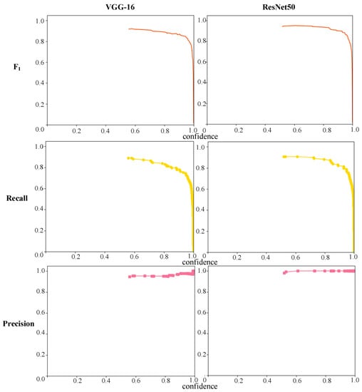
Figure 7.
Changes of F1, recall, and precision under different confidence levels.
The experimental evaluation indices illustrate that the improved Faster R-CNN network demonstrated outstanding performance, and the detection results of slope failure and landslide disasters are reliable, with ResNet50 demonstrating superior detection security. By inputting an image for testing into the trained model, the geological disasters of slope failure and landslide on the image were able to be predicted directly, as depicted in Figure 8. The blue box in Figure 8 indicates the rectangular boundary of slope failure and landslide, and the red box indicates the predicted range of slope failure and landslide.Figure 8c illustrates the predicted outcomes of VGG16, while Figure 8d shows the predicted results of ResNet50. Based on the sample’s detection results, VGG16 demonstrated higher accuracy in detecting small-scale slope failures and landslides compared to ResNet50. The predicted slope failures and landslides from VGG16 were more dispersed, which can result in a higher false detection rate compared to ResNet50.
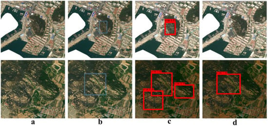
Figure 8.
Examples of VGG16 and ResNet50 test results: (a) original image; (b) label; (c) VGG16; (d) ResNet50.
However, both networks tended to miss some detections, as shown in Figure 9. The blue box in Figure 9 indicates the rectangular boundary of slope failure and landslide, and the red box indicates the predicted range of slope failure and landslide. Figure 9c represents the outcome of VGG16 prediction, and Figure 9d displays the outcome of ResNet50 prediction, both of which had some missed detections. Nonetheless, the missed detection ratio of both networks was relatively low, as the recall rate demonstrated an accuracy rate of approximately 90%, which is still considered a good level of accuracy.
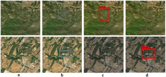
Figure 9.
Examples of missed detection results of VGG16 and ResNet50: (a) original image; (b) label; (c) VGG16; (d) ResNet50.
4.2. Experimental Parameters of Improved Faster R-CNN Network
During the experiments, the choice of parameter settings significantly impacts the results. In this study, a trial-and-error approach was employed to select the optimal parameters. Different combinations of parameter values were tested to find the best configuration. The Adam optimizer was chosen over SGD after careful comparison. SGD was found to be time consuming with slow convergence, while Adam demonstrated good convergence in a shorter time frame.
Considering the number of training iterations, the improved Faster R-CNN network consists of two stages: freezing and thawing. In the freezing stage, the feature extraction network of Faster R-CNN remains unchanged, while fine-tuning is performed. The thawing stage involves modifying the feature extraction network. In this experiment, 50 epochs were allocated for the freezing stage, with a total of 200 epochs. It was observed that, beyond 200 epochs, there was no significant improvement in experimental accuracy.
Regarding the confidence setting, it is essential to note its impact on the experiment. Confidence refers to the threshold used to determine whether the network’s detection sample corresponds to a landslide, and it directly influences the F1, recall rate, and precision of the network. In this study, the confidence threshold of 0.5 was set, which yielded more favorable results in terms of F1, recall rate, and precision.
4.3. Significance and Challenges of the Model
Compared to traditional methods, the Faster R-CNN network with a multi-scale feature enhancement module exhibits improved accuracy in locating and identifying slope failures and landslides. This advancement is crucial for identifying potential slope failure and landslide risks, establishing early warning systems, implementing appropriate prevention and control measures, and mitigating the impact of slope failures and landslides on people and property. Moreover, the improved Faster R-CNN network can serve as a foundation for identifying and detecting other similar geological disasters, such as mudslides. However, for the network to effectively detect mudslide, it is imperative to collect relevant datasets and optimize model parameters.
Nevertheless, the improved Faster R-CNN network still encounters challenges and limitations. Firstly, acquiring large-scale slope failure and landslide training data presents a formidable task, particularly in regions with harsh environments. Secondly, the model’s recognition capabilities during the training and testing stages may prove insufficient for certain slope failure and landslide samples. Consequently, there is a possibility of high false alarm rates and missed detections. Both backbone feature extraction networks suffer from missing detection issues. Additionally, the VGG16 network has a higher false-positive rate, with some of the predicted targets being smaller and scattered. Therefore, a comprehensive approach should be adopted in practical applications to strike a balance between accuracy and reliability. Lastly, the complex nature of the slope failure and landslide environment and its susceptibility to external factors, such as weather and seasonal changes, can cause variations in the appearance and characteristics of slope failure and landslide areas. These variations, in turn, can impact the accuracy and stability of the slope failure and landslide detection model.
5. Conclusions
The two-stage detection algorithm has distinct advantages over other detection algorithms in terms of target detection accuracy. In this study, the improved Faster R-CNN network was utilized to detect slope failure and landslide occurrences in Huangdao District, Qingdao, Shandong Province, and the following conclusions were drawn:
- Based on the experimental results, it is evident that the enhanced Faster R-CNN networks equipped with VGG-16 and ResNet-50 backbone networks demonstrate exceptional performance in detecting slope failure and landslide. Both models achieved an impressive overall accuracy of approximately 90%, indicating reliable and dependable detection outcomes. The ResNet50 model with the better detection performance is the superior backbone network in this regard, exhibiting an AP value of 90.68%, an F1 value of 0.94, a recall rate of 90.68%, and a precision value as high as 98.17%. Although VGG16 has more dispersed prediction targets and a higher false detection rate than ResNet50, it is more effective in predicting small-scale slope failure and landslide disasters.
- In the case of Huangdao District, the images were divided with overlapping sections and fed into the enhanced Faster R-CNN network for prediction. The prediction results from each section were then stitched together. The detection outcomes revealed that the vast majority of slope failure and landslide points were accurately identified, with only two points going undetected. This showcases the network’s ability to achieve high accuracy in detecting slope failure and landslide geological disasters.
It is important to acknowledge that the method proposed in this study may not possess universal or consistent ability to detect slope failures and landslides with similar spectral characteristics to bare land. This limitation arises from the complexity and diversity of such geological disasters. Furthermore, the two-stage target detection algorithm may experience slow speed, thereby presenting potential issues. Therefore, the future research goal is to overcome these challenges and build a more efficient deep learning geological disaster detection network.
Author Contributions
Conceptualization, Y.G. and L.Y.; data curation, L.Y.; formal analysis, Y.G. and L.Y.; funding acquisition, M.H.; investigation, L.L.; methodology, Y.G., L.Y. and M.H.; project administration, Y.G.; resources, S.H. and L.L.; supervision, M.H.; validation, S.H. and X.Z.; visualization, X.Z.; writing—original draft, Y.G.; writing—review and editing, L.Y. All authors have read and agreed to the published version of the manuscript.
Funding
This research was funded by National Natural Science Foundation of China, grant number 42271368.
Institutional Review Board Statement
Not applicable.
Informed Consent Statement
Not applicable.
Data Availability Statement
The data used to support the findings of this study are available from the corresponding authors upon request.
Conflicts of Interest
The authors declare that they have no conflicts of interest regarding the publication of this paper.
References
- Ji, S.; Yu, D.; Shen, C.; Li, W.; Xu, Q. Landslide detection from an open satellite imagery and digital elevation model dataset using attention boosted convolutional neural networks. Landslides 2020, 17, 1337–1352. [Google Scholar] [CrossRef]
- Ghorbanzadeh, O.; Blaschke, T.; Gholamnia, K.; Meena, S.R.; Tiede, D.; Aryal, J. Evaluation of Different Machine Learning Methods and Deep-Learning Convolutional Neural Networks for Landslide Detection. Remote Sens. 2019, 11, 196. [Google Scholar] [CrossRef]
- Lin, R.F.; Liu, J.P.; Xu, S.H.; Liu, M.M.; Zhang, M.; Liang, E.J. Evaluation method of landslide susceptibility based on random forest weighted information. Sci. Surv. Mapp. 2020, 45, 131–138. [Google Scholar] [CrossRef]
- Xu, J.H.; Sun, D.L.; Wang, Y.; Wen, H.J.; Wang, Z.Z. Landslide Susceptibility Mapping of Fengjie County Based on GIS and Improved Analytic Hierarchy Process. J. Chongqing Norm. Univ. 2020, 37, 36–44. [Google Scholar] [CrossRef]
- Chen, S.J.; Kang, Q.; Shen, Z.Q.; Zhou, R.C. Landslide Detection Based on Color Feature Model and SVM in Remote Sensing Imagery. Spacecr. Recovery Remote Sens. 2019, 40, 89–98. [Google Scholar]
- Guo, Z.Z.; Yin, K.L.; Fu, S.; Huang, F.M.; Gui, L.; Xia, H. Evaluation of Landslide Susceptibility Based on GIS and WOE-BP Model. Earth Sci. 2019, 44, 4299–4312. [Google Scholar] [CrossRef]
- Yang, G.H.; Jian, W.X.; Zhang, S.P.; Fu, Z.Y. Discrimination step points of step-landslides based on ensemble learning. Chin. J. Geol. Hazard Control. 2019, 30, 1–8. [Google Scholar] [CrossRef]
- Zhang, X.; Li, S.S.; Wei, G.F.; Zhang, X.N.; Gao, J.W. Fine-grained Object Detection in Remote Sensing Images Based on Multi-scale Features. J. Remote Sens. 2022, 26, 2616–2628. [Google Scholar] [CrossRef]
- Chen, X.; Wan, M.J.; Ma, C.; Chen, Q.; Gu, G.H. Small Object Detection in Remote Sensing Images using Multi-scale Feature Fusion SSD. Opt. Precis. Eng. 2021, 29, 2672–2682. [Google Scholar] [CrossRef]
- Liu, B.J.; Xing, X.D.; Wu, H.; Shao, S.H.; Zan, J. Remote Sensing Recognition Method for Tailings Dam based on Deep Learning Support. Sci. Surv. Mapp. 2021, 46, 129–139. [Google Scholar] [CrossRef]
- He, X.; He, Z.Y. A Preliminary Discussion on the Application of Deep Learning Technology to the Automatic Identification of Landslide. Acta Geol. Sichuan 2021, 41, 508–511. [Google Scholar] [CrossRef]
- Ohnishi, Y.; Nishiyama, S.; Yano, T. A study of the application of digital photogrammetry to slope monitoring systems. Int. J. Rock Mech. Min. 2006, 43, 756–766. [Google Scholar] [CrossRef]
- Bhatt, J.; Gangwar, A.; Nijhawan, R.; Gangodkar, D. A Research on Deep Learning Advance for Landslide Classification using Convolutional Neural Networks. Int. J. Innov. Technol. Explor. Eng. 2019, 8, 2278–3075. [Google Scholar] [CrossRef]
- Ma, H.R.; Feng, T.J.; Ji, R. High-Resolution Remote Sensing Image Land Cover Classification Based on FCN and Object-Oriented Method. Hubei Agric. Sci. 2022, 61, 163–168. [Google Scholar] [CrossRef]
- Xu, Z.Y.; Shen, Z.F.; Li, Y.; Zhao, L.F.; Ke, Y.M.; Li, L.L.; Wen, Q. High-Resolution Remote Sensing Image Classification with Enhanced DeepLab Algorithm and Adaptive Loss Function. J. Remote Sens. 2022, 26, 406–415. [Google Scholar] [CrossRef]
- Zhang, P.Q.; Liu, B.; Zuo, X.B.; Y, X.C. Spatial-spectral Feature Classification of Hyperspectral Image Using Deep Convolutional—Recurrent Neural Network. J. Geomat. Sci. Technol. 2021, 38, 368–373. [Google Scholar]
- Cui, W.; He, X.; Yao, M.; Wang, Z.; Li, J.; Hao, Y.; Wu, W.; Zhao, H.; Chen, X.; Cui, W. Landslide Image Captioning Method Based on Semantic Gate and Bi-Temporal LSTM. ISPRS Int. J. Geo-Inf. 2020, 9, 194. [Google Scholar] [CrossRef]
- He, J.F.; Chen, H.W.; Luo, D.H. Overview of Real-time Semantic Segmentation Algorithms Based on Deep Learning. Comput. Eng. Appl. 2023, 59, 13–27. [Google Scholar] [CrossRef]
- Yang, H.J.; Li, L.Q.; Wang, D. Deep Learning Image Restoration Combining Semantic Segmentation and Edge Reconstruction. J. Image Graph. 2022, 27, 3553–3565. [Google Scholar]
- Wang, Y.X.; Wu, Y.G.; Xu, C.G. Infrared Warship Target Detection Algorithm Based on Deep Transfer Learning. Aerosp. Def. 2021, 4, 61–66. [Google Scholar] [CrossRef]
- Biswajit, J.; Krishna, N.G.; Sanjay, S. Convolutional neural network and its pretrained models for image classification and object detection: A survey. Concurr. Comput. Pract. Exp. 2021, 34, 6767. [Google Scholar] [CrossRef]
- Ju, Y.Z.; Xu, Q.; Jin, S.C.; Li, W.L.; Dong, X.J.; Guo, Q.H. Automatic Object Detection of Loess Landslide Based on Deep Learning. Geomat. Inf. Sci. Wuhan Univ. 2020, 45, 1747–1755. [Google Scholar] [CrossRef]
- Yang, X.; Wang, F.; Bai, Z.; Xun, F.; Zhang, Y.; Zhao, X. Deep Learning-Based Congestion Detection at Urban Intersections. Sensors 2021, 21, 2052. [Google Scholar] [CrossRef] [PubMed]
- Zhang, X.; Yang, W.; Tang, X.; Liu, J. A Fast Learning Method for Accurate and Robust Lane Detection Using Two-Stage Feature Extraction with YOLO v3. Sensors 2018, 18, 4308. [Google Scholar] [CrossRef]
- Li, S.; Gu, X.; Xu, X.; Xu, D.; Zhang, T.; Liu, Z.; Dong, Q. Detection of concealed cracks from ground penetrating radar images based on deep learning algorithm. Constr. Build. Mater. 2021, 273, 121949. [Google Scholar] [CrossRef]
- Lai, W.; Zhou, M.; Hu, F.; Kai, B.; Song, H. Coal Gangue Detection Based on Multi-Spectral Imaging and Improved YOLO v4. Acta Opt. Sin. 2020, 40, 2411001. [Google Scholar] [CrossRef]
- Girshick, R.B.; Donahue, J.; Darrell, T.; Malik, J. Rich feature hierarchies for accurate object detection and semantic segmentation. In Proceedings of the 2014 IEEE Conference on Computer Vision and Pattern Recognition, Columbus, OH, USA, 23–28 June 2014; pp. 580–587. [Google Scholar] [CrossRef]
- Jena, R.; Pradhan, B.; Alamri, A.M. Susceptibility to Seismic Amplification and Earthquake Probability Estimation Using Recurrent Neural Network (RNN) Model in Odisha, India. Appl. Sci. 2020, 10, 5355. [Google Scholar] [CrossRef]
- He, K.; Zhang, X.; Ren, S.; Sun, J. Spatial Pyramid Pooling in Deep Convolutional Networks for Visual Recognition. IEEE T. Pattern Anal. 2015, 37, 1904–1916. [Google Scholar] [CrossRef]
- Girshick, R.B. Fast R-CNN. In Proceedings of the 2015 IEEE International Conference on Computer Vision (ICCV), Santiago, Chile, 7–13 December 2015; Institute of Electrical and Electronics Engineers Inc.: Piscataway, NJ, USA; pp. 1440–1448. [Google Scholar] [CrossRef]
- Shaoqing, R.; Kaiming, H.; Ross, G.; Jian, S. Faster R-CNN: Towards Real-Time Object Detection with Region Proposal Networks. IEEE T. Pattern Anal. 2017, 39, 1137–1149. [Google Scholar] [CrossRef]
Disclaimer/Publisher’s Note: The statements, opinions and data contained in all publications are solely those of the individual author(s) and contributor(s) and not of MDPI and/or the editor(s). MDPI and/or the editor(s) disclaim responsibility for any injury to people or property resulting from any ideas, methods, instructions or products referred to in the content. |
© 2023 by the authors. Licensee MDPI, Basel, Switzerland. This article is an open access article distributed under the terms and conditions of the Creative Commons Attribution (CC BY) license (https://creativecommons.org/licenses/by/4.0/).