1. Introduction
Climate extremes have massive impacts on society and are becoming more severe and frequent [
1,
2]. The associated risks of droughts are evolving in response to climate variations superimposed on forced climate changes. Droughts are among the most severe hazards for rural areas, and their cascading impacts affect, among other things, agricultural harvest production and water availability [
3]. Furthermore, these direct impacts of changing weather can affect human health through exposure of the agricultural workforce to hazards.
Several studies have indicated that climate extremes such as drought are likely to increase in the future, which poses a greater threat to those in rural areas [
4]. Climate change can exacerbate land degradation processes, including increases in drought frequency and severity [
5]. Increases in the frequency of droughts are projected to negatively affect local crop production, especially in subsistence sectors at low latitudes [
6]. Most of the recent research related to drought in rural areas has focused on agricultural productivity, without integrating the rural context [
7]. Agricultural production is shaped by many interrelated factors that are affected by climate variations. One of the most prominent challenges crops face related to climate is drought, identified as the main natural hazard recognized by farmers in the Chapada Diamantina region, where this research was conducted [
8].
According to a report by the United Nations Office for Disaster Risk Reduction (UNDRR), in the period 2000–2019, there were 338 (5%) drought-related disasters, while between 1980 and 1999, 263 (6%) were registered, and 1.43 billion (35%) people were affected by drought during 2000–2019 [
9]. In the specific case of Brazil, according to the Brazilian Atlas of Natural Disasters, the country is exposed to a variety of natural disasters that are increasingly frequent and intense, and droughts accounted for 48% of disasters between 1991 and 2012. The Northeast region concentrates approximately 56% of the country’s drought cases, and this type of disaster most affects the population due to its recurrence, with 51% of the population affected [
10].
The Food and Agriculture Organization (FAO) of the United Nations indicates that the agriculture sector is vulnerable and exposed to weather and climate extremes. In developing countries such as Brazil, losses attributed to climate-related disasters (e.g., floods, droughts, storms) that impacted agriculture increased 26% between 2006 and 2016. Agriculture absorbed 82% of all damage and losses caused by drought between 2008 and 2018, with 49% of the damage and losses affecting crops [
11,
12].
The literature, concepts, and notions regarding drought can be defined in different ways. The term drought used in this article refers to environmental drought, according to the IPCC definition. According to the glossary concept by the 2018 Intergovernmental Panel on Climate Change (IPCC), drought is defined as a period of abnormally dry weather long enough to cause a severe hydrological imbalance [
13]. Drought is a relative term; therefore, any discussion in terms of precipitation deficit must refer to the particular precipitation-related activity under discussion. A period with an abnormal precipitation deficit is defined as a meteorological drought [
13]. Drought can also be defined as a sustained and regionally extensive occurrence of below-average natural water availability as a deviation from the long-term conditions of variables such as precipitation [
14]. The IPCC also indicates that the term drought may refer to meteorological drought (precipitation well below average), hydrological drought (low river flows and water levels in rivers, lakes, and groundwater), agricultural drought (low soil moisture), and environmental drought (a combination of the above). The socioeconomic impacts of droughts may arise from the interaction between natural conditions and human factors, such as changes in land use and land cover and water demand and use. The concept of risk thus characterizes a peculiar, intermediate state between security and destruction, where the perception of threatening risks determines thought and action [
15].
Recent data from the International Emergency Disasters Database (EM-DAT) [
16], a worldwide disaster database maintained by the Centre for Research on the Epidemiology of Disasters (CRED), indicate the severe effects of drought in Brazil from 1970 to 2020. EM-DAT estimates that 25 disasters related to drought events occurred in this period in the country, resulting in approximately 78.8 million people affected and 21 deaths. The main disaster types for the period in Brazil are floods (60%), followed by landslides (10%) and droughts (9%). Regarding economic losses due to episodes of drought in this period, in Brazil, losses were approximately 14.2 million dollars. Brazil has a continental size, and not all regions suffer these extreme events; approximately 42% of these events are located in the Northeast. The Northeast region of Brazil is one of the five official and political regions of the country, according to the Brazilian Institute of Geography and Statistics (IBGE). It comprises nine states: Maranhão, Piauí, Ceará, Rio Grande do Norte, Paraíba, Pernambuco, Alagoas, Sergipe, and Bahia. To give an idea of how large this area is, the Brazilian Northeast region area is equivalent to approximately four times the size of Germany.
Climate model projection indicates that an increase in droughts over semiarid low latitudes in the summer is likely towards the end of the 21st century [
17]. For the agriculture and forest sector, it also shows a likely scenario of increased future trends of drought hazards related to the increased risk of wildfire, according to a report by the IPCC [
17]. In Brazil, large rural populations in the Northeast region are exposed to drought. There are significant impacts on the production and yields of maize and soybean crops and livestock production. While economic losses due to the reduction in agricultural and livestock production affect the region, especially the most vulnerable people, these losses include an increase in unemployment, diseases, and migration [
14].
The objective of this study is to examine the drought impacts in rural territories. In addition to data and technical information on climate and rising temperatures and the lack of rain, this study also seeks to understand: What is the perspective of family farmers in this context? What are the material and non-material impacts they experience? What are the individual perceptions of changes in the way of life, in social relationships, and at work?
2. Study Area
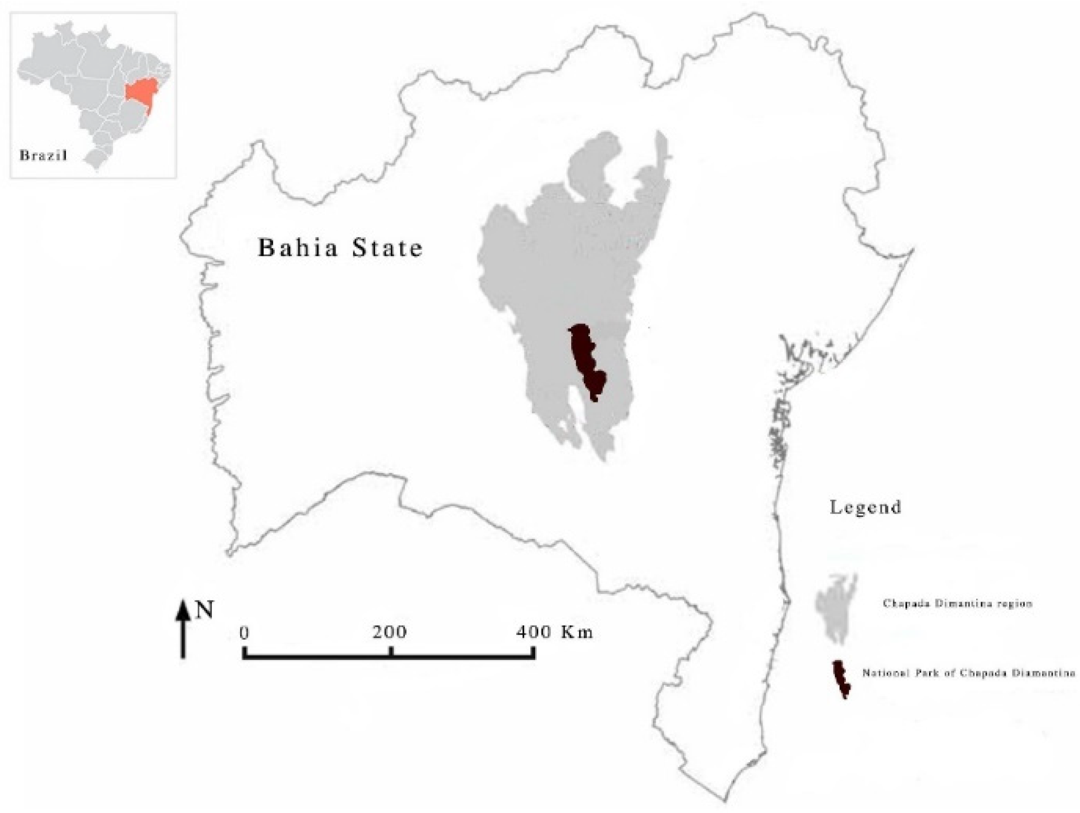
The study area is the Chapada Diamantina region located in the state of Bahia in Northeast Brazil. The Chapada Diamantina region has the caatinga biome and contains its highest elevations, most above 500 m. The 25 municipalities from the Chapada Diamantina region are: Abaíra, Andaraí, Barra da Estiva, Boninal, Bonito, Ibicoara, Ibitiara, Iramaia, Iraquara, Itaeté, Jussiape, Lençóis, Marcionílio Souza, Morro do Chapéu, Mucugê, Nova Redenção, Novo Horizonte, Palmeiras, Piatã, Rio de Contas, Seabra, Souto Soares, Tapiramutá, Utinga, and Wagner. This region is home to Chapada Diamantina National Park [
18], an integral protection unit, with an area of 1521 km
2. The basis of economic activity is family farming, mainly with the production of coffee and cassava, the breeding of small animals (including goats, pigs, and donkeys), and the production of fruits and vegetables. This region has tropical humidity, a rainy tropical climate, and a hot semiarid climate, with an average annual temperature of 27.8 °C and an average annual rainfall of 846 mm. This area is also a hotspot of extremely high temperatures, with a high risk of fire occurrence in Brazil, especially the region of the Chapada Diamantina located in the center of the state (see
Figure 1).
The area of the Chapada Diamantina region has approximately 31,381 km
2 and a population of approximately 376,000 inhabitants, of which 50% are rural populations [
19,
20]. The area of this region is equivalent to the size of the Brandenburg state in Germany. For this study area’s territory, drought is classified as a very severe hazard (2000–2019), with moderate projection [
21]. The study area region has a long history of managing and living among these challenging conditions related to drought [
22].
2.1. Meteorological Data
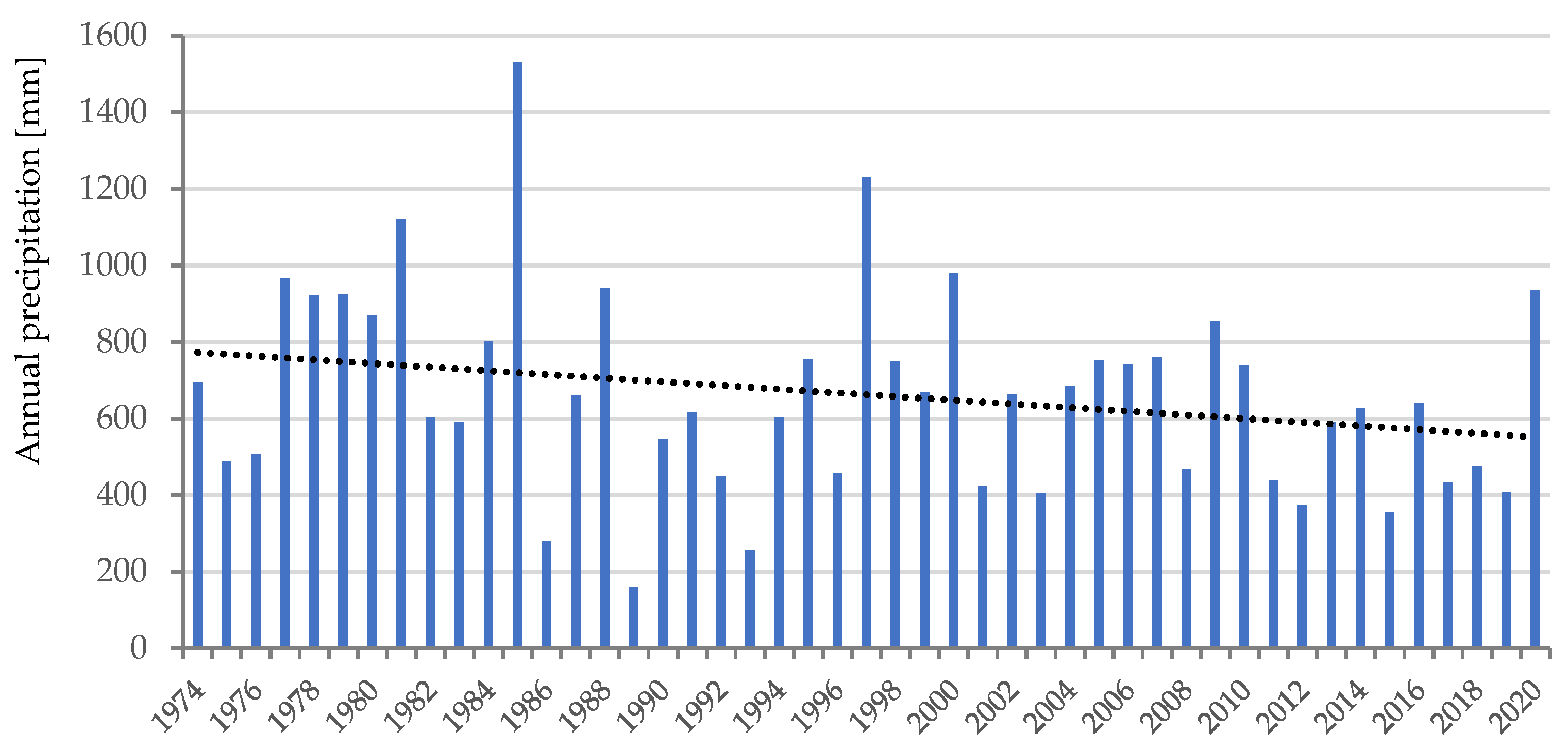
The analysis was performed using a database comprising data from the National Water Agency (ANA) [
23], from seven meteorological stations in the region to calculate the median value. The meteorological stations with data from 1974 to 2020 are: Lençóis (station code 83242; latitude: −12.557854; longitude: −41.388808), Morro do Chapéu (station code 83184; latitude: −11.547494; longitude: −41.151165), and Ibotirama (station code A439; latitude: −12.19305555; longitude: −43.21333333). The meteorological complementary stations with data from 2008–2020 are: Brumado (station code A433; latitude: −14.18194443; longitude: −41.67222221), Irece, Itaberaba (station code A408; latitude: −12.52416666; longitude: −40.29972221), and Vitória da Conquista (station code A414; latitude: −14.88638888; longitude: 40.80138888). The individual analysis of these stations indicates certain data variability that might result from the topography in the area. The meteorological data in the Chapara Diamantina region indicate a high volume of rainfall in the region but also a significant number of days without rain. These data show the climatic variability of the concentration of rain in a few periods compared to long periods of drought, which heavily impacts local agriculture. The annual precipitation has a decreasing tendency. The year 1989 stands out as a year of low rainfall, with 160 mm of rain (see
Figure 2).
Calculating the standardized precipitation index (SPI; the analysis of drought through the SPI does not take evapotranspiration into account) of the time series with 47 observations reveals a classification between moderately dry (average SVI = −1.22) and severely dry (SVI = −1.92) observations during 2009 in the region. The region of Lençóis registered the lowest drought values in the period (average SVI = +1.06). According to the index classification, the drought in the region has had a decreasing tendency since 2008. According to data from satellite-based indices regarding droughts in the study area from the Brazilian drought monitor [
24], in general, during 2020, the Bahia region presented, based on the short- and long-term SPI indicators, a significant reduction in the severe drought area in the central range of the state, which now presents as moderate drought. More specifically, in the Chapada Diamantina region during the months of September to November, when the questionnaires were answered, the region varied between no drought and mild drought conditions.
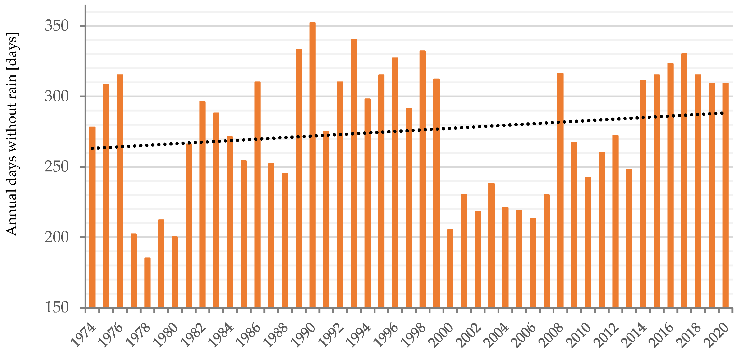
The hazards related to extreme natural phenomena on Chapada Diamantina include drought, high temperatures, and fire occurrence. The days without rain had an increasing tendency between 1974 and 2020 for the region. The analysis of drought was performed by calculating the annual days without rain in the region and indicated 352 days without rain in 1990 (see
Figure 3).
2.2. Rural Production
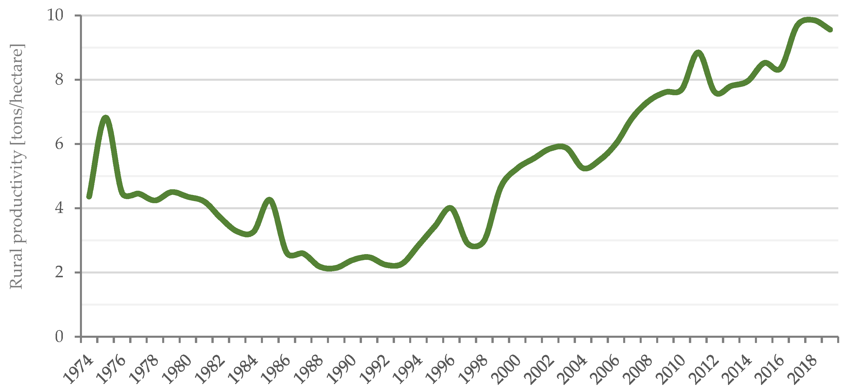
Increasing agricultural productivity was observed in temporary and permanent crops, mainly since 2000 (see
Figure 4), according with database from the Brazilian Institute of Geography and Statistics (IBGE) [
25]. However, it must be considered that the IBGE data for total group production in the region may not reflect the reality of an agricultural family subject to a lack of water. According to the IBGE Agricultural Census from 2017, in Brazil, approximately 77% of establishments are family agriculture, occupying approximately 22% of the country’s area. In the state of Bahia, around 78% of the establishments are family agriculture, occupying near 32% of the state’s area; family agriculture contributes 22.8% to national production and 25% to production in the state of Bahia. Chapada Diamantina is estimated to use 40% of its area for family agriculture [
26].
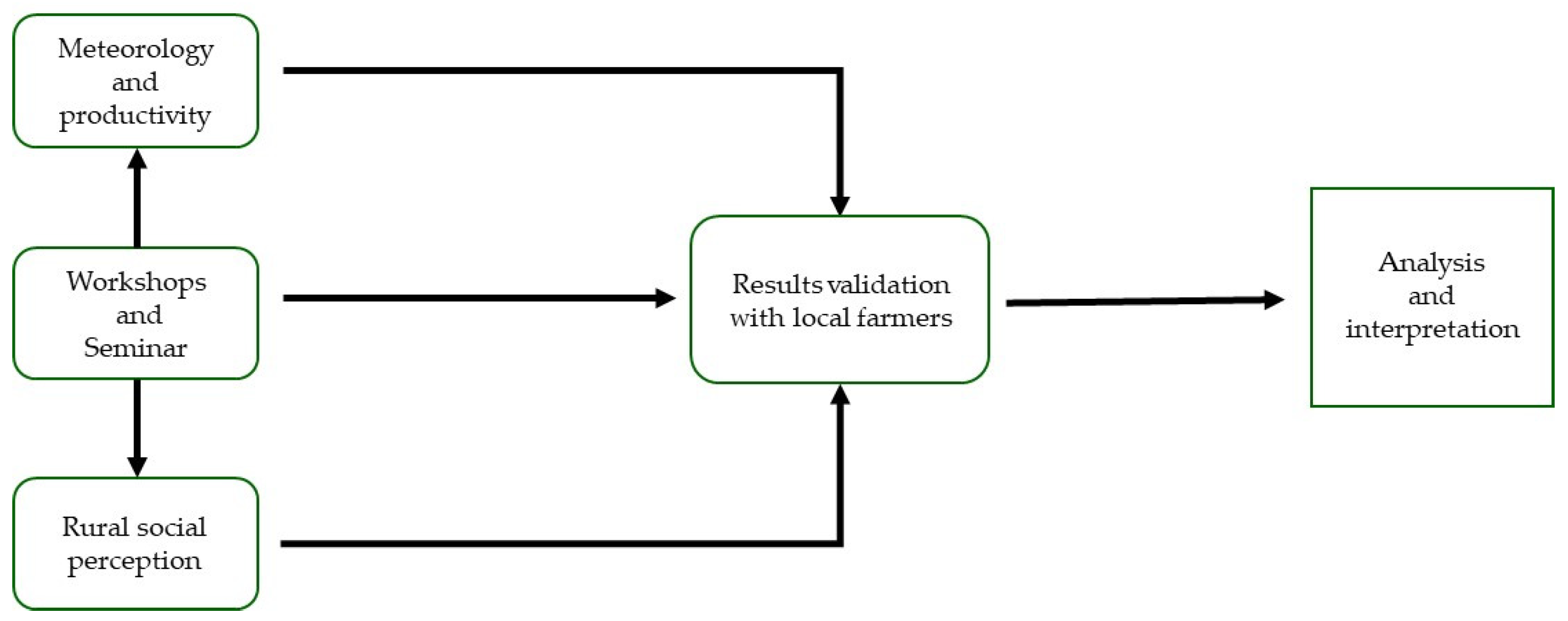
3. Materials and Methods
The method used in this study to collect social perceptions of drought-related impacts on small rural producers was based on a participatory process. To better understand the individual perceptions of rural producers in the Chapada Diamantina region for diagnosing the material and nonmaterial impacts of drought, two approaches were used to collect data: meeting discussions and questionnaire surveys. This research followed four main stages: (
Section 3.1) collection of historical meteorological and agricultural productivity data; (
Section 3.2) participatory diagnosis containing dialogue meetings, questionnaire preparation, and application; (
Section 3.3) perception surveys carried out with rural producers in the region; and (
Section 3.4) results validation (see
Figure 5). The following subsections describe each of these stages in detail.
3.1. Meteorological and Agricultural Data
The historical meteorological data between 1974 and 2020 from Chapada Diamantina were obtained from the National Water Agency (ANA) database. The climatic aspects were obtained from ANA in seven meteorological stations in the region. The historical rural productivity data between 1974 and 2019 were obtained from the Brazilian Institute of Geography and Statistics (IBGE). The data were obtained by consolidating statistics on the quantity produced and the area used in the 25 municipalities in the region.
3.2. Participatory Diagnosis
The participatory diagnosis was conducted, on a local level, regarding the impacts of drought between August and December 2020 from the perspective of family farming in the areas of health, income, social relations, and the environment. It was a collective construction on individual and collective perceptions of rural community agents (ACRs) and rural producers. Rural producers are beneficiaries of the Bahia Productive Project, a project of the Government of the State of Bahia, carried out by the Regional Action and Development Company (CAR), a public company linked to the Secretariat for Rural Development (SDR). The participatory diagnosis consisted of dialogue meetings and survey questionnaires. The dialogue meetings were organized with rural community agents to understand how drought events affected rural producers as a participatory dynamic activity during 2020. Two online activities were organized, each with 18 rural community agents and four facilitators.
3.3. Perception Surveys
Questionnaires are a popular and fundamental tool for acquiring information on public knowledge and the perception of natural hazards [
27,
28]. The surveys were based on closed- and open-ended questions applied to rural producers in the region in 2020 and were answered during the months of September, October, and November. The surveys were prepared and discussed with local rural agents, and changes were made according to suggestions for their local reality. The quantitative data used online questionnaires administered by local agents. For the analysis of the primary data sample size in a population of 753 small farmers, 280 questionnaires were answered, and 276 were considered valid for analyses. The exclusion criteria for the four questionnaires were based on the refusal of the participants to allow the use of the data in the research analysis. Considering the confidence level of 95%, the margin of error of the study was 4.7%. Among the municipalities, a varying number of survey respondents was observed, which was the result of the low availability of internet access for the farmers during the survey. The surveys used online questionnaires administered in situ by rural community agents (ACRs). The questionnaires were anonymous. It is important to emphasize that during the survey collection, the region was suffering a fire that occurred due to extreme temperatures.
3.4. Results Validation
The results were validated with rural agents and rural producers. With rural agents, the results were validated during dialogue meetings, and the results of the questionnaires answered by local rural producers were discussed and validated. The validation criteria consisted first of a discussion on whether the methodology and research material were suitable for the context, followed by a dialogue where the results were presented in graphic form, including the meteorological and agricultural characterization of the study area, followed by the survey results, where space for discussion was opened if the data reflected the context of the study area. The local agents also made comments regarding the experience of developing this kind of activity of social perception of the drought impacts. With rural producers, the results were validated at a seminar that was organized after the dialogue meetings, and the surveys were collected and analyzed. The seminar was participated in by 21 rural producers and 15 ACRs. During the seminar, the results were validated and pointed to agroecology as a possibility of living with drought.
4. Results
The results in this section present the social perception data collected in the region. The data show the results from each stage of the integrated assessment of social perception described in detail in the subsection regarding natural hazards, health, social, income, and other impacts.
During meeting discussions to understand the drought impacts, rural community agents (ACRs) outlined their perceptions and experiences about the effects of drought on local rural producers. Thus, an integrated diagnosis of the impacts related to drought was built. The results of the discussions indicated several kinds of impacts in different sectors related to health, income, the environment, and social relations.
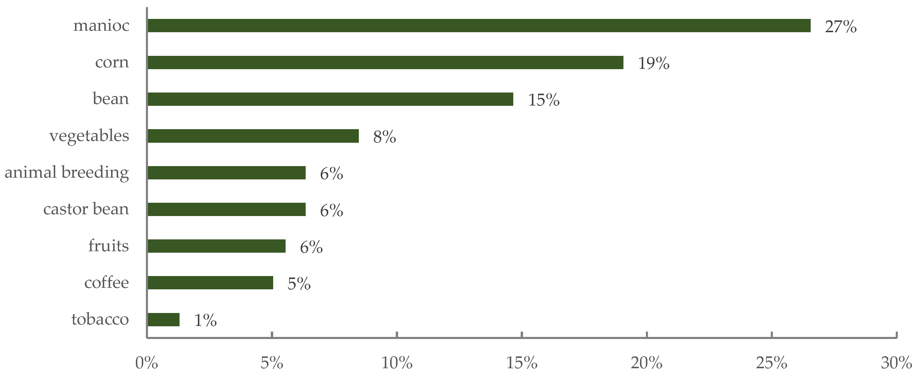
The survey results are divided into five subjects: (i) natural hazards, (ii) health, (iii) social, (iv) income, and (v) other impacts. The survey respondents were typically (51%) 31–50 years of age, followed by 27% who were 51 years or older, and 20% between 18 and 30 years. Most of the respondents were female (70%). Concerning the residence location, meaning urban or rural, 98% lived in a rural area. Manioc took first place regarding the main cultivated products, followed by corn and bean (see
Figure 6).
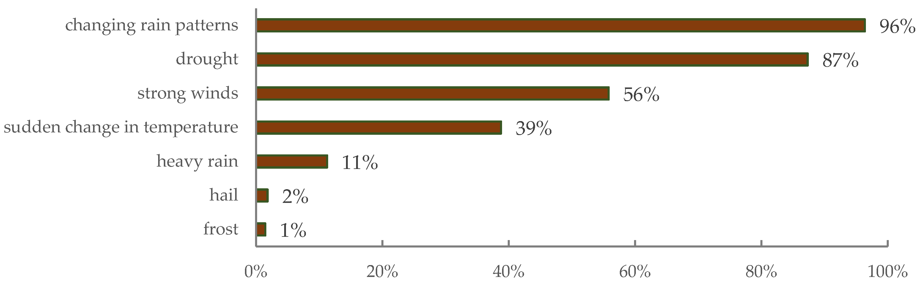
4.1. Perception of Drought Impacts Associated with Natural Hazards
Regarding the phenomenon that most impacts rural activity, changing precipitation patterns (96%) and drought (87%) were the most common extreme natural events that rural producers worry about (see
Figure 7). The impacts of drought on the environment are expressed in reducing water and, therefore, production.
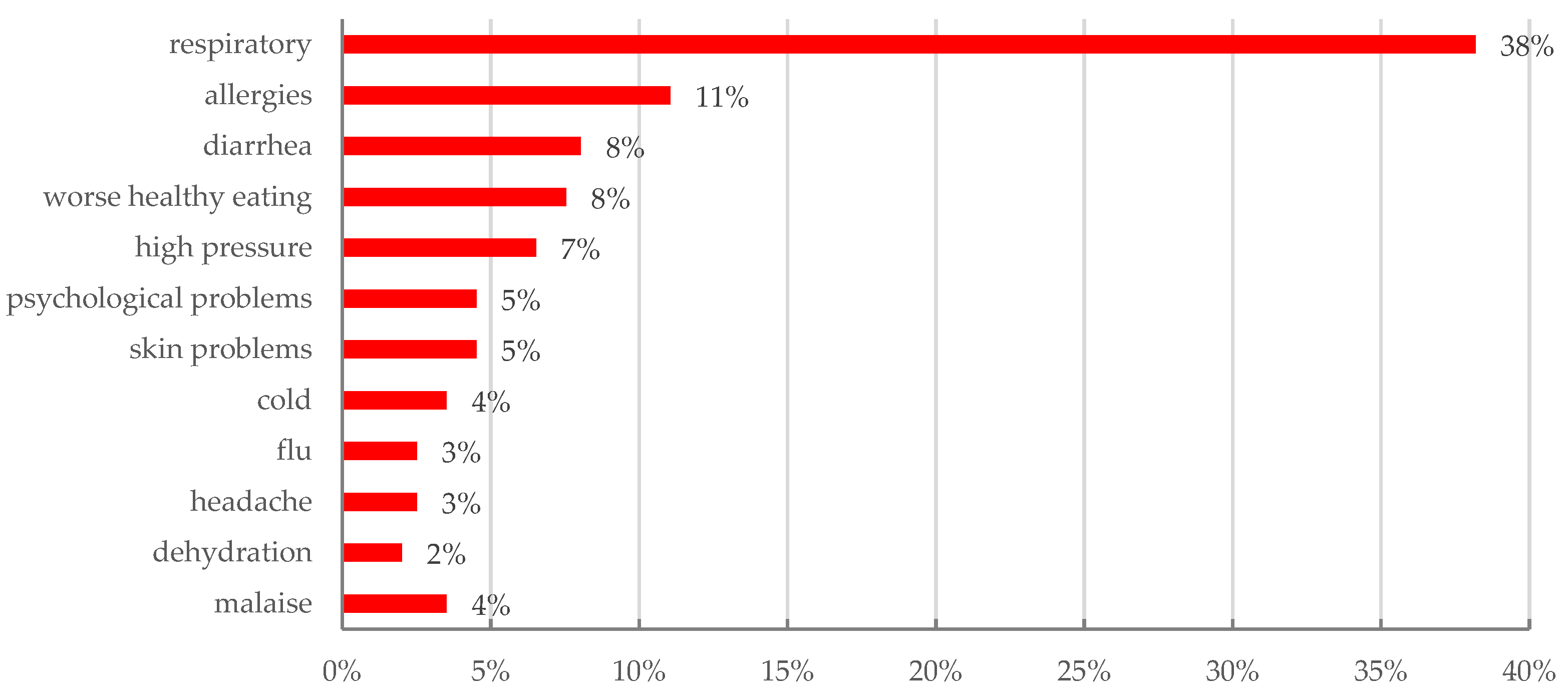
4.2. Perception of Drought Impacts Associated with Health
Regarding the drought impacts associated with health, respiratory problems were perceived to be impactful by the most respondents of all different age groups: 20% among those between 19 and 30 years old, 52% between 31 and 50 years old, and 28% for those 51 years or older. Most of the impacts related to drought are respiratory symptoms, diarrhea problems, or allergies resulting from skin irritation as a result of the dry, high temperatures and the number of particles suspended in the air (see
Figure 8). This period is also commonly associated with fire occurrence in the region.
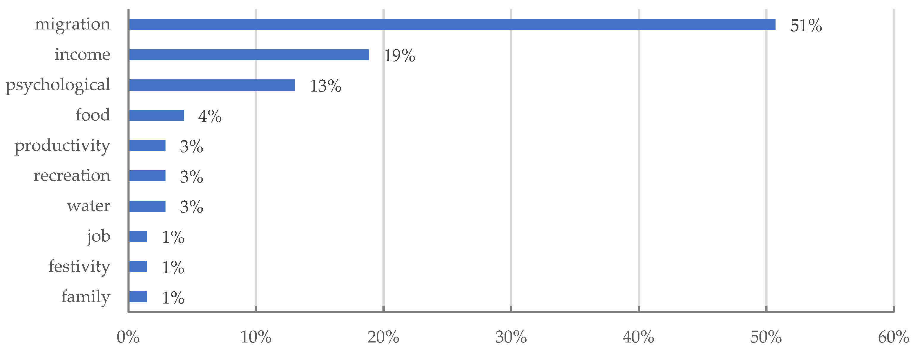
4.3. Perception of Drought Impacts Associated with Social Activities and Behaviors
Regarding the drought impacts associated with social activities and behaviors, migration aspects are perceived to be impactful for most respondents (51%). The other main impacts are related to income and psychology (see
Figure 9). This domestic migration in Brazil is characterized by a flux population caused by low rural incomes, for example to big cities in the Southeast and South of the country or new agricultural frontiers.
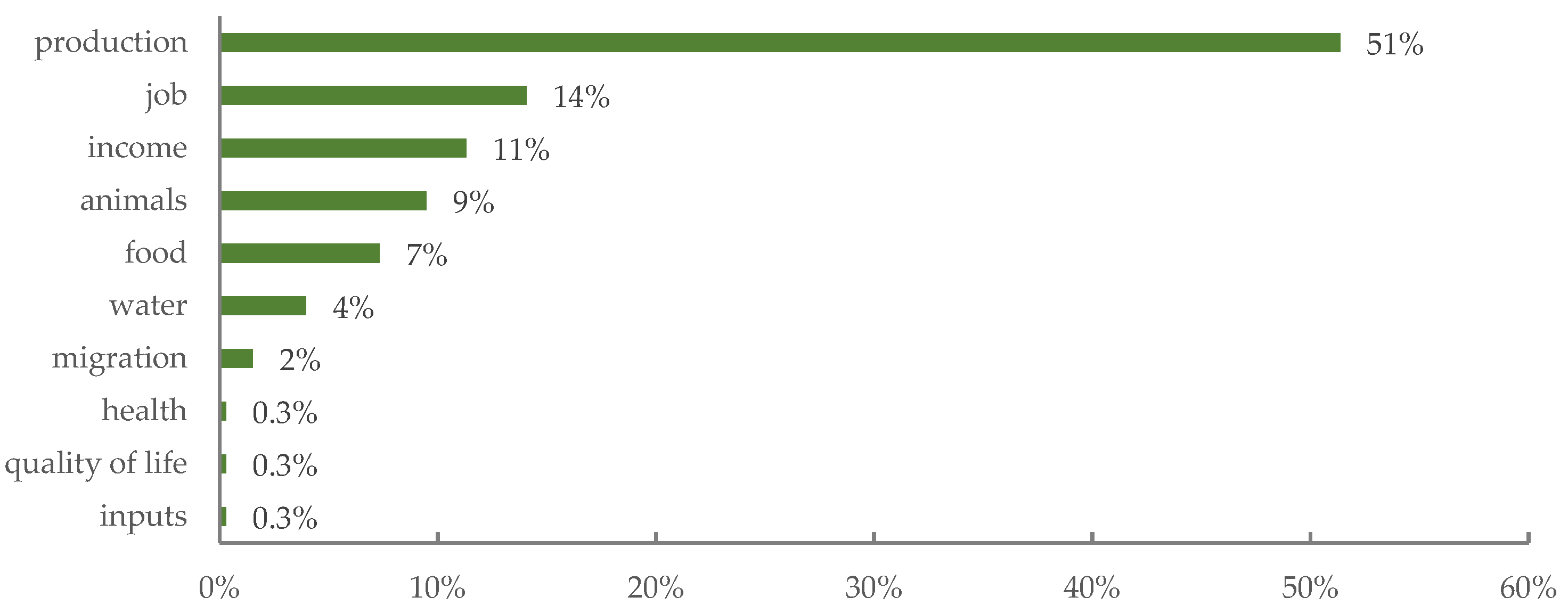
4.4. Perception of Drought Impacts Associated with Income
The drought impacts associated with income result from losses in cultivation that also affect social relationships, especially with migration (see
Figure 10).
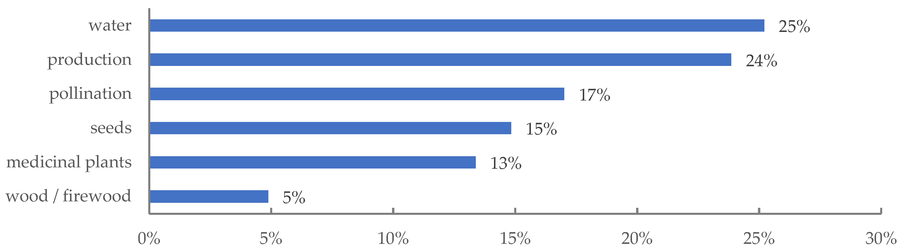
4.5. Perception of Drought Impacts Associated with Other Impacts
The other impacts resulting from drought which had not been indicated before include pollination, seeds, access to medicinal plants, and wood related to environmental services from the region (see
Figure 11).
5. Discussion
This study presents two typologies of data: quantitative historical data on the meteorological and agricultural production of rain, temperature, and rural productivity, and qualitative data on social perceptions from surveys collected by the authors. The proposal is not to compare these data but to understand the relationships between these two sets of parameters for the context in this region [
29].
The historical analysis of drought disasters indicated that according to the EM-DAT data of Brazil’s deaths, just 0.22% of natural disaster deaths were due to drought between 1970 and 2020. This number underestimates the impacts, as it often excludes indirect deaths from malnutrition, disease, and displacement, which are among the primary outcomes of droughts. Droughts take a high human toll in terms of agricultural income production, migration, and respiratory health problems. Drought is a normal part of climate variations, and climate scenarios suggest an increase in droughts in the future.
By observing the meteorological data and analyzing the most recent data from between 2011 and 2020, two extremes appear, the first in 2015 with the lowest precipitation (356 mm) and the second in 2020 with the highest precipitation (935 mm) [
23].
Regarding agricultural productivity, it was observed that between 2010 and 2019, there was stabilization, with an average production of 8.6 tons/hectare. The region had a productivity of 9.6 tons/hectare in 2019, while in 1988 this productivity was 2.2 tons/hectare, with a productivity increase rate for the period of 336%. Brazil had a productivity of 13.3 tons/hectare in 2019, whereas this rate was 5.6 tons/hectare in 1988, with a productivity increase rate for the period of 136% [
26]. Rural productivity appears to be affected by drought in the study area, which is reflected in the loss of income. Agriculture already has adapted to long periods of drought, as social technologies for water production are part of the landscape of the Chapada Diamantina region, such as the cultivation of shaded coffee. The historical data in the region show an increasing trend (although later stable) for agricultural production in ‘contrast’ with the responses from the interviews, which might not reflect the reality of family agriculture in the region.
We observed with the results from the social perceptions that changing rain patterns and drought are the main perceived hazards. Rain and drought are indicated as the greatest hazards for most farmers in rural areas, which is consistent with the FAO study indicating that in developing countries, 82% of all damage and loss caused by drought is absorbed by agriculture [
11,
12]. During 2020 when social perception data were collected, a record volume of rain was recorded, showing that there is a social memory of this society that understands drought as an extremely serious event in the region. This is consistent with the analysis of other types of data, such as meteorological data. These social perception results indicated how an extreme event such as drought influenced other aspects, such as health with respiratory problems and social relations with migration. These social perceptions of drought impacts confirm the literature [
5], indicating that drought impacts develop slowly, sometimes indirectly, and may last long after the drought itself ends.
6. Conclusions
We conclude that our study provides evidence that supports the understanding of social perception of natural hazards in rural areas considering more than the direct impacts of drought. The perceptions of rural producers depend on what their society has experienced. The methodology adopted in this research allowed the authors to conduct an integrated assessment of the drought impacts.
The information obtained with the social perception instruments indicated aspects related to emotional values from an integrated perspective, such as access for their local organic food, migration, and health changes. The drought event provoked many changes, not just in crop plants but also in rural society. For the regional context studied, the social perception of drought-caused impacts was observed across different areas. Family farming has a considerable representation in the defined region. It is a social segment of significant socioeconomic importance in the context of the territory. Although historically marginalized, it is in smallholdings and polyculture that the production of essential foods is concentrated and occupies the local fairs of the municipalities in the region. However, climatic conditions hinder production and limit productive results. It is observed that the use of cisterns, resulting from public support and financing policies, associated with the use of social technologies is among the considerable solutions presented. During the results validation seminar with rural producers, it was possible to observe interculturality as a central element when considering regional knowledge.
In the study, the agricultural productivity variable was not included in the applied questionnaire. The reason was to keep the survey short, which is a recommendation to consider in the future. An analysis regarding the SVI drought index with monthly resolution is required for a better evaluation. The authors also recommend including aspects of the characteristics of drought, e.g., severity or dry area, for further surveys.
Finally, due to the adopted participatory method, it is worth highlighting the democratic nature of this study′s construction and dissemination of knowledge. In proposing a collective mobilization, this research prioritized the collaborative perspective to recognize the impacts of drought in the local scenario. In this sense, researchers, technicians, local community agents, and family farmers were able to identify, analyze, and appropriate the findings.


 and
and 