1. Introduction
Agriculture is undergoing a rapid digital transformation driven by remote sensing, geospatial technologies, artificial intelligence (AI), machine learning (ML), deep learning (DL), Internet of Things (IoT), and cloud computing [
1,
2,
3,
4]. The emergence of Agriculture 4.0 and Agriculture 5.0 has accelerated the development of data-driven systems for crop monitoring, yield forecasting, disease detection, irrigation optimization, and climate adaptation [
5,
6]. Remote sensing platforms such as Sentinel, Landsat, MODIS, hyperspectral sensors, and unmanned aerial vehicles (UAVs) now generate massive volumes of spatial and temporal agricultural data [
7,
8,
9].
DL approaches, especially convolutional neural networks (CNNs), recurrent neural networks (RNNs), transformers, and hybrid AI architectures, have significantly improved prediction accuracy in agricultural analytics [
10,
11,
12]. Despite their superior performance, many AI models operate as black-box systems with limited interpretability [
13]. This lack of transparency limits trust among farmers, agronomists, policymakers, and agricultural engineers, particularly in high-stakes applications such as food security assessment, water management, fertilizer recommendations, and climate-risk analysis [
14].
Explainable Artificial Intelligence (XAI) has emerged as a promising paradigm for addressing these limitations by enabling human-understandable explanations of AI predictions and decisions [
15]. XAI methods provide insight into feature importance, decision pathways, uncertainty, spatial attention, and model reliability [
16,
17]. In agriculture, XAI can help determine why a model classifies a crop as stressed, predicts disease outbreaks, or estimates soil salinity using spectral signatures [
18]. The increasing need for transparency in AI-driven agricultural systems has encouraged the integration of explainability into remote sensing analytics [
19]. Recent studies have demonstrated that interpretable AI frameworks improve decision confidence, reduce bias, and support sustainable agricultural management [
20,
21,
22]. Furthermore, explainability aligns with emerging ethical AI regulations and supports responsible innovation in precision agriculture [
23].
The growing dependence on AI-based agricultural decision-support systems has also intensified concerns regarding reproducibility, uncertainty quantification, and operational reliability. Many advanced DL models can achieve very high predictive performance while simultaneously masking the internal reasoning process behind predictions. This issue becomes particularly problematic in agriculture because agronomic decisions are strongly influenced by environmental variability, local management practices, and socioeconomic conditions. Consequently, agricultural stakeholders increasingly demand AI systems capable of generating transparent recommendations supported by scientifically interpretable evidence. Another important challenge involves the integration of heterogeneous geospatial datasets.
Agricultural monitoring frequently relies on multi-source observations collected from optical sensors, SAR imagery, hyperspectral platforms, UAV systems, weather stations, and IoT networks. Although these datasets improve analytical performance, they also increase model complexity and reduce interpretability. XAI frameworks therefore play a critical role in identifying the relative importance of spectral, temporal, climatic, and environmental variables within integrated agricultural models.
Recent developments in explainable remote sensing have expanded beyond simple feature importance analysis toward causal reasoning, uncertainty-aware learning, and human-centered AI systems. Attention mechanisms and visualization-based techniques are now being integrated into operational agricultural workflows to facilitate communication between AI systems and end users. This transition reflects a broader movement toward trustworthy agricultural intelligence capable of supporting sustainable food systems, climate adaptation, and precision resource management.
The scientific importance of XAI in agriculture extends beyond technical model interpretation. Explainability contributes directly to sustainable development goals by improving resource-use efficiency, reducing environmental risks, and supporting evidence-based agricultural policies. Transparent AI systems may also facilitate technology adoption among smallholder farmers by increasing user confidence and reducing skepticism toward automated decision-support tools.
Although several review studies have examined explainable artificial intelligence (XAI) in remote sensing, ecology, machine learning, or agricultural applications, a comprehensive synthesis integrating explainable AI, remote sensing technologies, and sustainable smart agriculture remains limited. Existing reviews typically focus on specific methodological developments, particular agricultural applications, or general explainability concepts. In contrast, the present review provides an integrated framework linking XAI methods with remote sensing-based agricultural monitoring across crop management, soil assessment, water resources, yield prediction, climate adaptation, carbon monitoring, and multimodal geospatial analytics. Particular emphasis is placed on the role of interpretable AI in supporting sustainable agricultural decision-making and operational deployment. To highlight the distinct contribution of the present review and identify existing research gaps, a comparative summary of recent review studies is provided in
Table 1.
This review aims to provide a comprehensive synthesis of XAI applications in smart agriculture, with particular emphasis on interpretable remote sensing for sustainable decision-making. The review discusses the evolution of AI and remote sensing technologies in agriculture and examines the major XAI techniques and their agricultural applications. It further evaluates explainability approaches used in crop, soil, water, and climate monitoring while interpreting the findings and reported results from recent studies. In addition, the review identifies current challenges, limitations, and future research opportunities associated with the integration of explainable AI into agricultural remote sensing and precision agriculture systems.
2. Review Methodology
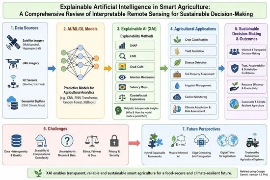
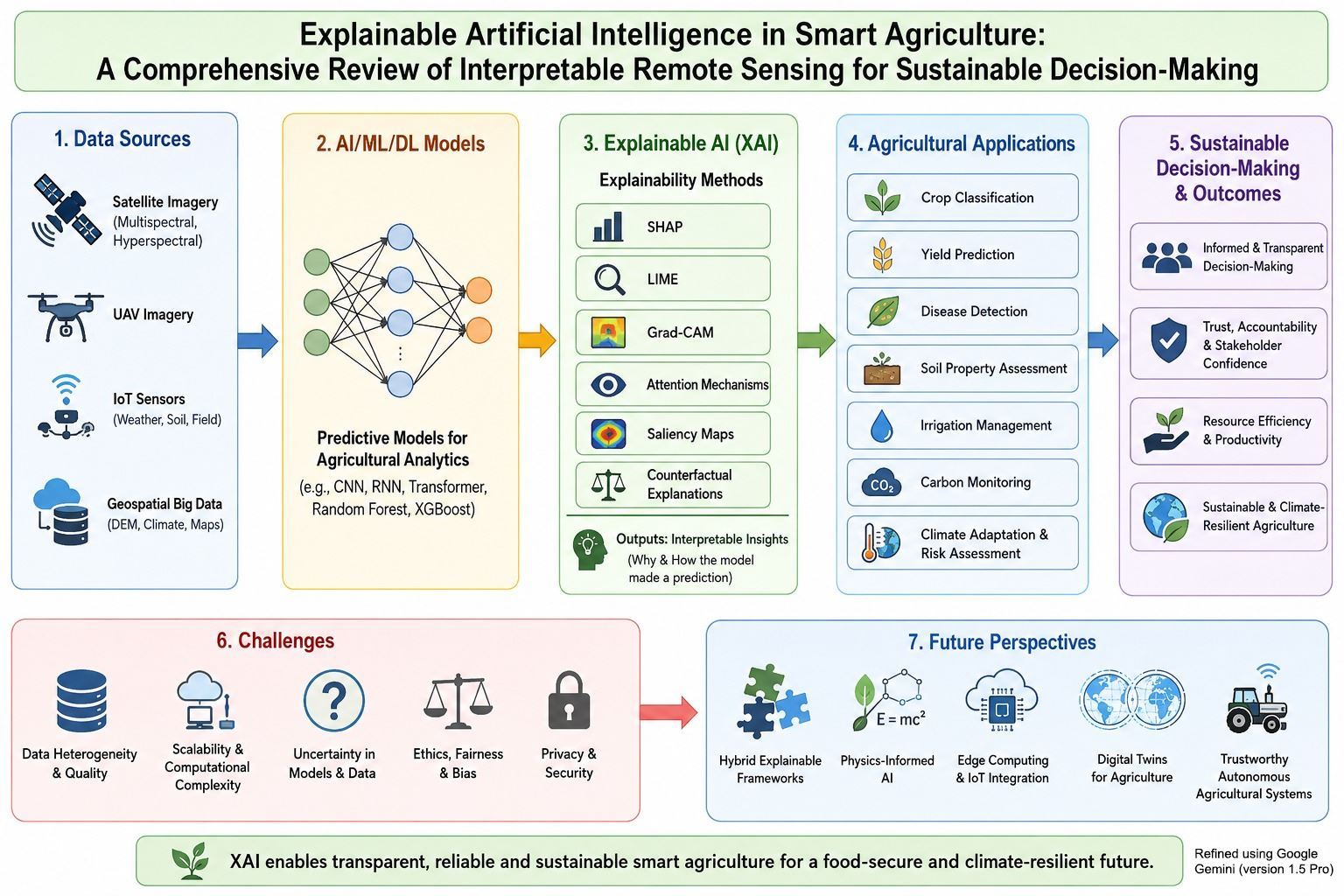
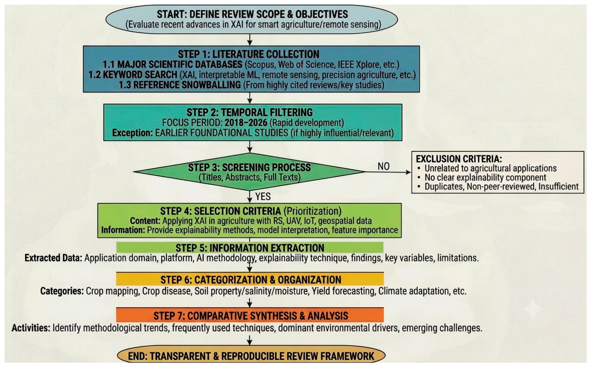
This review was conducted through a structured literature survey designed to identify and synthesize recent advances in Explainable Artificial Intelligence (XAI) for smart agriculture and remote sensing applications (
Figure 1). Relevant publications were collected from major scientific databases, including Scopus, Web of Science, ScienceDirect, IEEE Xplore, SpringerLink, and MDPI journals. The literature search focused on studies published primarily between 2018 and 2026, reflecting the period during which explainable artificial intelligence experienced rapid development and increasing adoption within agricultural and environmental research. Earlier studies were also considered when they introduced foundational concepts, methodologies, or explainability frameworks that remain highly influential in current research. The search process employed combinations of keywords related to explainable artificial intelligence, interpretable machine learning, remote sensing, precision agriculture, smart agriculture, crop classification, crop monitoring, crop disease detection, soil mapping, soil salinity assessment, soil moisture prediction, irrigation management, yield forecasting, climate adaptation, carbon monitoring, and geospatial analytics. Additional relevant publications were identified through the examination of reference lists from highly cited review papers and key methodological studies. Following the initial search, titles, abstracts, and full texts were screened to evaluate their relevance to the objectives of this review. The selection process prioritized peer-reviewed journal articles and conference papers that addressed the application of explainable artificial intelligence techniques within agricultural systems supported by remote sensing, unmanned aerial vehicles, Internet of Things technologies, geospatial data, or environmental monitoring platforms. Studies were included when they provided information regarding explainability methods, model interpretation, feature importance analysis, transparency assessment, or decision-support applications in agriculture. Publications unrelated to agricultural applications, studies lacking a clear explainability component, duplicate records, non-peer-reviewed documents, and articles with insufficient methodological information were excluded from further consideration. Information extracted from the selected studies included the agricultural application domain, remote sensing platform, data source, artificial intelligence methodology, explainability technique, major findings, dominant explanatory variables, and reported limitations. The reviewed literature was subsequently organized into thematic categories including crop mapping and classification, crop disease monitoring, soil property assessment, soil salinity mapping, soil moisture prediction, irrigation management, yield forecasting, climate adaptation, carbon monitoring, and multi-source data fusion. A comparative synthesis approach was adopted to identify common methodological trends, frequently used explainability techniques, dominant environmental drivers, emerging challenges, and future research directions across the different agricultural application domains. This structured review framework improves the transparency of the literature selection process and provides a reproducible basis for evaluating the current state of explainable artificial intelligence in smart agriculture and remote sensing.
3. Evolution of Smart Agriculture and Remote Sensing
3.1. Digital Transformation in Agriculture
Smart agriculture integrates sensing technologies, AI, robotics, cloud computing, and automation to optimize agricultural productivity and sustainability [
24]. Precision agriculture initially focused on site-specific management using GPS and GIS technologies; however, recent developments have expanded toward autonomous decision-support systems and predictive analytics [
25].
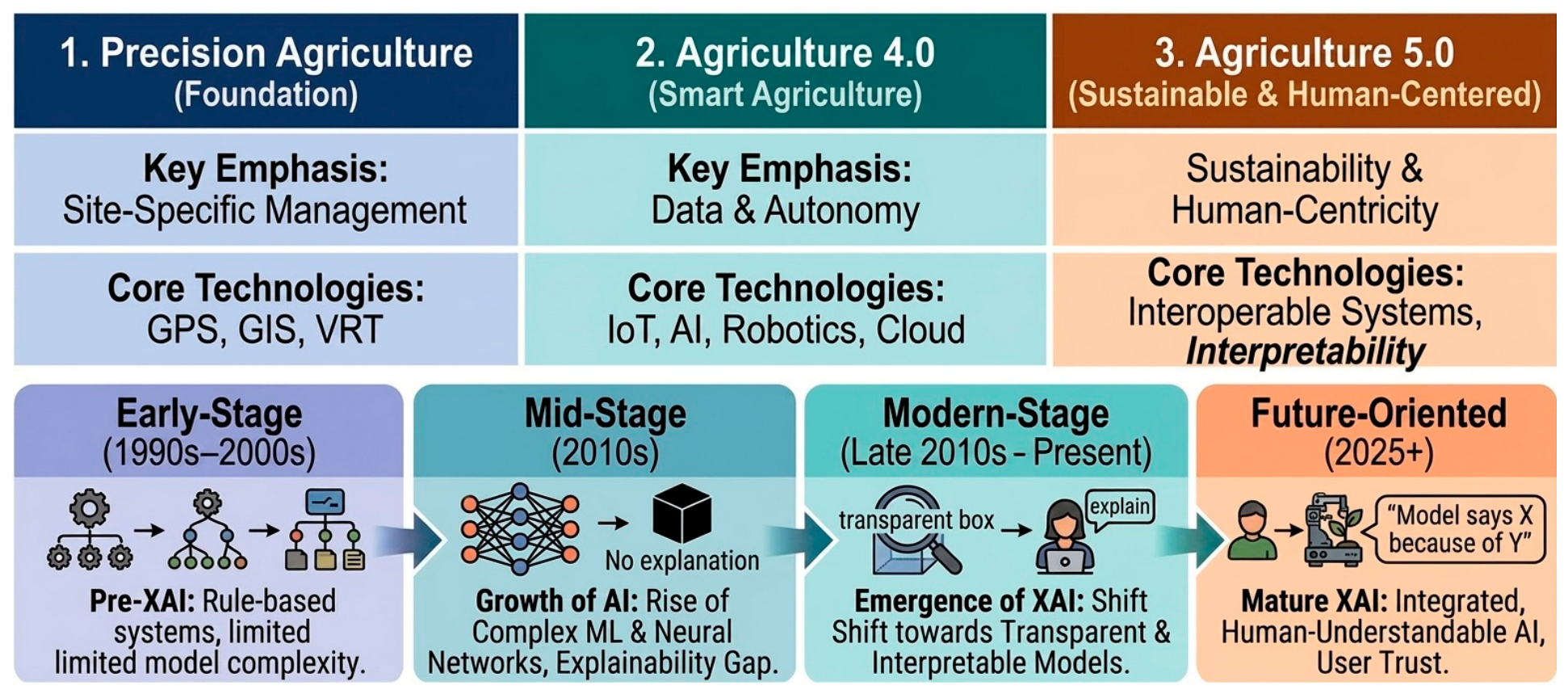
The transition from Agriculture 4.0 to Agriculture 5.0 (
Figure 2) emphasizes sustainability, climate resilience, resource efficiency, and human-centered AI systems [
26]. Agricultural management increasingly relies on near-real-time monitoring of crops, soil moisture, evapotranspiration, nutrient dynamics, and disease spread [
27].
Digital agriculture has fundamentally transformed the scale and speed at which agricultural decisions are made. Traditional field scouting methods are increasingly being replaced or complemented by automated sensing systems capable of monitoring crops continuously across large spatial areas. The availability of cloud-based geospatial platforms and open satellite archives has further accelerated data accessibility and analytical efficiency.
The rapid expansion of agricultural big data has created both opportunities and challenges. Large-scale datasets allow AI systems to identify hidden patterns and nonlinear relationships among environmental variables, crop growth dynamics, and management practices. However, this increasing complexity often results in reduced model transparency. Consequently, the development of interpretable AI systems has become essential for ensuring that agricultural recommendations remain scientifically understandable and operationally reliable.
Digital transformation has also facilitated the emergence of integrated agricultural ecosystems in which remote sensing, IoT sensors, farm machinery, and predictive analytics operate collaboratively. Such systems can support variable-rate fertilization, precision irrigation, disease forecasting, and carbon accounting. Nevertheless, these technologies require explainable frameworks capable of translating complex predictions into actionable recommendations that can be interpreted by farmers and agricultural advisors.
3.2. Remote Sensing Platforms in Agriculture
Remote sensing technologies provide spatially continuous information for agricultural analysis [
28]. Satellite platforms such as Landsat, Sentinel-1, Sentinel-2, MODIS, PlanetScope, and WorldView are widely used for crop classification and vegetation monitoring [
29]. UAVs enable ultra-high-resolution monitoring for precision agriculture applications [
30]. Hyperspectral sensors provide detailed spectral signatures useful for disease detection, nutrient estimation, and stress analysis [
31]. Microwave and SAR sensors improve agricultural monitoring under cloudy conditions and provide valuable information on soil moisture and crop structure [
32]. Studies have shown that multi-sensor fusion improves prediction performance compared with single-source imagery [
33]. For example, integrating Sentinel-1 SAR and Sentinel-2 optical data increased crop classification accuracy by 8–15% in several agricultural regions [
34]. This improvement demonstrates the complementary nature of structural and spectral information. Remote sensing systems differ substantially in spatial, temporal, radiometric, and spectral resolution, which directly influences their suitability for agricultural applications. High-resolution commercial satellites are useful for detailed crop assessment at field scale, whereas moderate-resolution systems such as MODIS are more appropriate for regional and global monitoring. UAVs provide exceptional spatial detail but may face limitations related to coverage area, flight regulations, and operational costs.
The integration of optical, thermal, hyperspectral, and microwave sensors has expanded the analytical capabilities of precision agriculture. Thermal imagery can reveal crop water stress through canopy temperature variations, while hyperspectral data capture subtle biochemical changes associated with nutrient deficiency and disease development. SAR systems contribute additional structural information and enable monitoring under cloudy conditions where optical systems fail. Interpretation of remote sensing results increasingly requires explainable frameworks because spectral responses are often influenced by multiple interacting factors. For instance, reduced NDVI values may result from drought stress, disease infestation, nutrient deficiency, or soil background effects. XAI techniques help disentangle these relationships by identifying the dominant explanatory variables influencing model predictions.
Another important development involves near-real-time agricultural monitoring through cloud computing platforms such as Google Earth Engine and AI-enabled geospatial infrastructures. These systems allow continuous processing of massive Earth observation datasets, thereby supporting early warning systems, crop insurance applications, and climate-risk monitoring.
3.3. AI and Deep Learning in Agricultural Remote Sensing
ML algorithms including Random Forest (RF), Support Vector Machines (SVMs), XGBoost, and Artificial Neural Networks (ANNs) have been widely used in agricultural remote sensing [
35]. DL methods have further improved image classification and temporal prediction tasks [
36]. CNN-based models have achieved classification accuracies exceeding 95% for crop-type mapping using high-resolution imagery [
37]. Transformer architectures and attention-based models are increasingly used for spatiotemporal analysis and phenological monitoring [
38]. Nevertheless, the complexity of these models creates significant interpretability challenges.
The integration of AI into agricultural remote sensing (
Figure 3) has revolutionized the ability to process large and complex geospatial datasets. Traditional statistical approaches often struggled to capture nonlinear relationships among environmental variables, vegetation dynamics, and management practices. DL architectures now enable automated extraction of spatial, spectral, and temporal features directly from raw imagery. CNNs have become particularly important in image-based agricultural applications because they can identify hierarchical visual patterns associated with crop stress, disease symptoms, canopy structure, and land-cover characteristics. Recurrent neural networks and long short-term memory (LSTM) models have additionally improved temporal prediction tasks by capturing seasonal and phenological variations in agricultural systems.
Transformer architectures represent another major advancement in agricultural AI because they can model long-range dependencies within large spatiotemporal datasets. Attention mechanisms embedded within transformers help identify the most relevant spatial regions or temporal periods influencing predictions. Such capabilities are especially valuable for crop growth monitoring and yield prediction. Despite these advantages, the increasing complexity of AI architectures often reduces interpretability. High predictive accuracy alone may not guarantee scientific reliability because AI systems can occasionally learn spurious correlations or environmentally unrealistic relationships. Explainable AI therefore becomes essential for validating whether models focus on agronomically meaningful variables. Recent studies have demonstrated that explainability analyses can reveal important environmental drivers influencing model behavior. For example, vegetation indices, temperature anomalies, rainfall patterns, and soil moisture frequently emerge as dominant predictive variables in agricultural AI systems. Such interpretations improve scientific understanding and increase stakeholder confidence in AI-driven recommendations.
AI models are also increasingly integrated with cloud computing and edge intelligence systems to support real-time agricultural monitoring. Autonomous drones, smart irrigation systems, and robotic platforms now rely on AI-driven image analysis for rapid field assessment. The future of agricultural remote sensing will therefore depend heavily on the development of interpretable, efficient, and scalable AI frameworks capable of operating under diverse environmental conditions.
Table 2 summarizes the major remote sensing platforms, typical AI approaches, and their agricultural applications used in smart agriculture systems.
4. Explainable Artificial Intelligence: Concepts and Frameworks
4.1. Definition and Importance of Xai
XAI refers to methods and frameworks that make AI decisions understandable to humans [
44]. XAI aims to improve transparency, accountability, fairness, and trust while preserving predictive performance [
45].
In agriculture, explainability is critical because decisions affect food production, water resources, environmental sustainability, and economic stability [
46]. Farmers and decision-makers require interpretable outputs rather than opaque predictions.
The importance of XAI in agriculture has increased substantially with the rapid expansion of deep learning and autonomous decision-support systems. Traditional statistical models generally provide interpretable relationships between variables and outputs; however, modern deep neural networks often involve millions of parameters and highly nonlinear interactions that are difficult to understand. Although these models achieve excellent predictive performance, the inability to explain predictions creates operational uncertainty.
Agricultural systems are inherently complex because crop growth, soil dynamics, climate variability, irrigation practices, and pest interactions are strongly interconnected. As a result, agricultural stakeholders need AI systems capable of explaining why particular decisions are generated. For example, a farmer receiving irrigation recommendations may need to understand whether the recommendation was driven primarily by canopy temperature, precipitation deficits, soil moisture conditions, or evapotranspiration patterns.
Explainability is also important for scientific validation. Agronomic experts frequently evaluate whether AI-generated explanations are biologically meaningful and consistent with established agricultural knowledge. If an AI model highlights irrelevant image regions or unrealistic environmental relationships, researchers may question model reliability despite high predictive accuracy.
Furthermore, explainable AI contributes to sustainable agriculture by improving transparency in environmental monitoring and resource management. Transparent AI systems may reduce excessive fertilizer application, improve irrigation efficiency, and support environmentally responsible agricultural practices. Consequently, XAI is increasingly recognized not only as a technical requirement but also as a fundamental component of trustworthy and sustainable agricultural intelligence.
4.2. Categories of XAI Methods
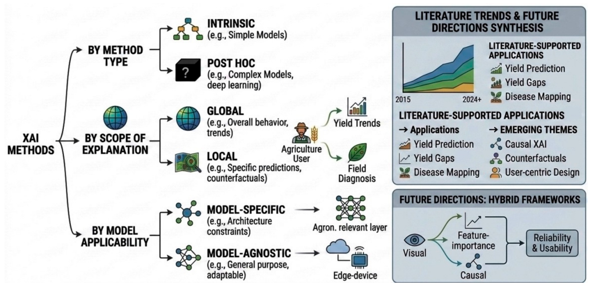
XAI approaches can generally be classified into several categories, including intrinsic explainability methods, post hoc explainability methods, global explanation techniques, local explanation techniques, model-specific methods, and model-agnostic methods (
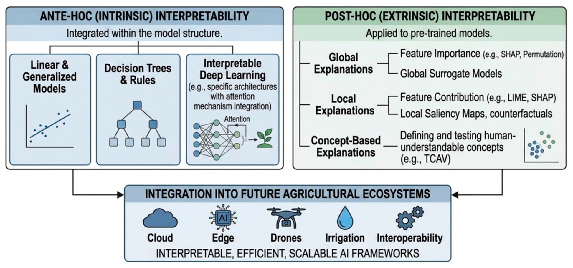
Figure 4). Intrinsic explainability methods involve inherently interpretable models, whereas post hoc approaches are designed to explain complex black-box models after training. Global explanation techniques aim to describe the overall behavior of a model, while local explanation techniques focus on interpreting individual predictions. In addition, model-specific methods are developed for particular AI architectures, whereas model-agnostic methods can be applied across different types of ML and DL models. Intrinsic explainability involves inherently interpretable models such as decision trees and linear regression [
47]. Post hoc methods interpret black-box models after training [
48].
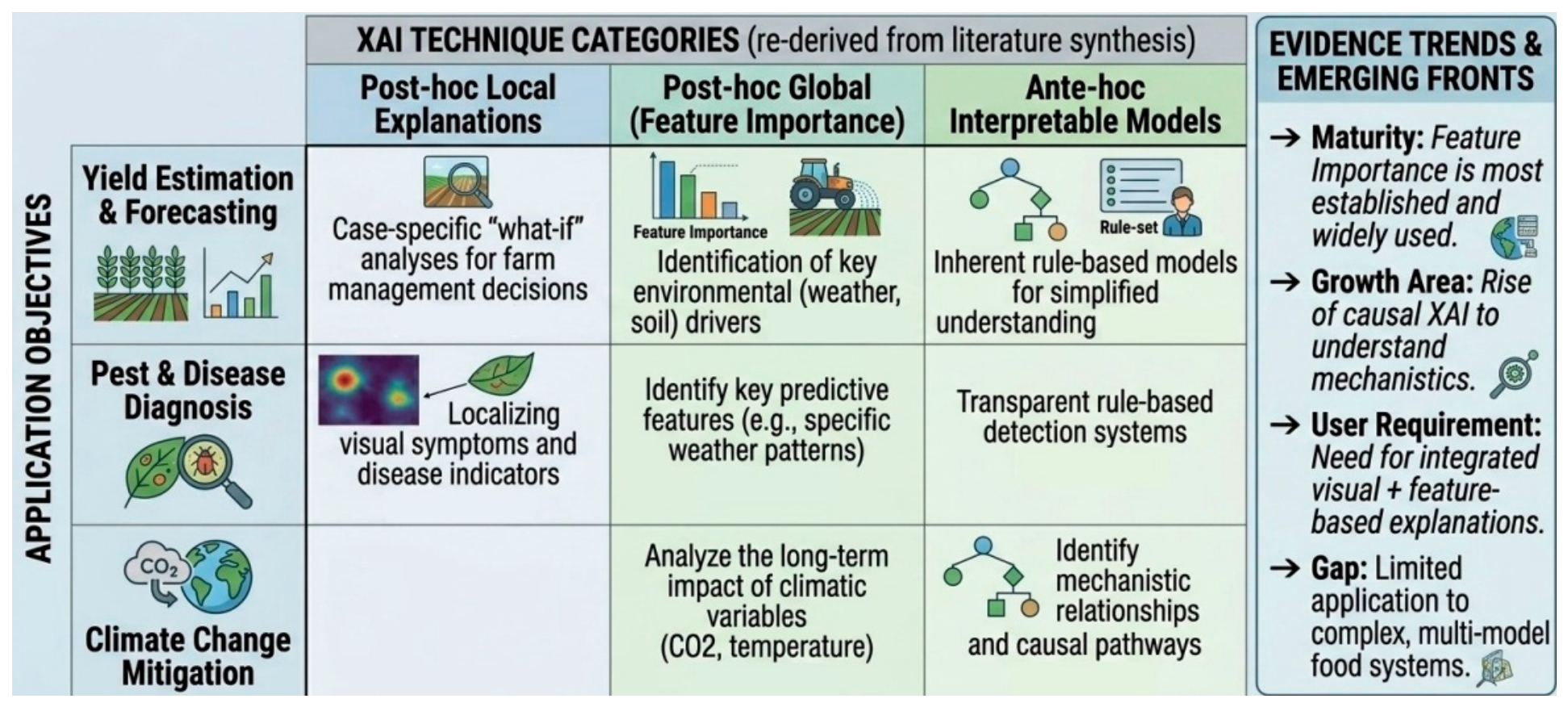
Global explainability methods attempt to describe the overall behavior of AI systems across complete datasets. These approaches are useful for understanding general feature importance, model sensitivity, and decision trends in agricultural monitoring systems. For example, global explainability can identify which climatic variables most strongly influence crop yield prediction models over multiple growing seasons.
In contrast, local explainability methods focus on individual predictions. These methods are particularly valuable in precision agriculture because agricultural conditions vary substantially across fields and time periods. Local explanations can help determine why a specific field was classified as drought stressed or why a disease outbreak was detected in a particular crop region.
Model-specific explainability approaches are designed for particular AI architectures such as CNNs, tree-based ensembles, or transformers. These methods often provide highly detailed interpretations but may lack flexibility across different model types. Conversely, model-agnostic methods can be applied to various AI systems regardless of architecture, thereby improving adaptability in heterogeneous agricultural applications.
Another important classification distinguishes between visual, feature-based, and causal explainability methods. Visual methods such as saliency maps and Gradient-weighted Class Activation Mapping (Grad-CAM) provide spatial interpretation of image-based predictions, whereas feature-based methods quantify the relative importance of environmental variables. Causal explainability attempts to identify mechanistic relationships among variables and outcomes.
The selection of an appropriate explainability framework depends on several factors including data type, spatial scale, model complexity, computational cost, and user requirements. Agronomists may prefer visually interpretable heatmaps, whereas policymakers may require quantitative feature rankings and uncertainty estimates. Consequently, explainability should be viewed as a multidimensional process rather than a single analytical technique.
Explainability categories are also closely linked to operational agricultural objectives. For instance, disease monitoring systems often require local visual explanations for rapid field diagnosis, whereas climate adaptation studies may rely more heavily on global explainability approaches capable of identifying long-term environmental drivers.
Future explainability frameworks are expected to integrate multiple categories simultaneously through hybrid architectures combining visual interpretation, feature importance analysis, uncertainty quantification, and causal reasoning. Such integrated approaches may substantially improve the reliability and usability of agricultural AI systems.
4.3. Major Explainability Techniques
4.3.1. Shapley Additive Explanations (SHAP)
SHAP is a game-theoretic explainability framework that quantifies the contribution of individual features to model predictions based on Shapley values from cooperative game theory. SHAP quantifies the contribution of each feature to model predictions [
49]. In agricultural remote sensing, SHAP has been used to identify the importance of vegetation indices, temperature, rainfall, and soil moisture in crop yield models.
Several studies reported that NDVI, EVI, and soil moisture consistently exhibited the highest SHAP values for yield prediction models [
50]. This finding suggests that vegetation vigor and water availability remain dominant drivers of agricultural productivity.
One of the major advantages of SHAP is its strong theoretical foundation derived from cooperative game theory. SHAP values provide consistent and additive feature attribution, allowing researchers to compare the relative importance of variables across different models and datasets. This capability is particularly useful in agricultural systems characterized by highly nonlinear interactions among climatic, soil, and vegetation variables.
In remote sensing applications, SHAP has been extensively applied to interpret spectral indices, thermal information, and radar backscatter responses. Feature attribution analyses frequently reveal that red-edge vegetation indices and canopy temperature play dominant roles in stress detection and productivity estimation. Such findings align closely with established agronomic knowledge regarding crop physiological responses.
SHAP analysis additionally facilitates the identification of threshold effects and nonlinear environmental relationships. For example, increasing soil moisture may positively influence yield predictions up to an optimal range, after which additional moisture may produce diminishing or negative effects. These interpretations help researchers better understand environmental constraints affecting agricultural productivity.
Another important advantage of SHAP involves transparency in operational decision-support systems. Farmers and policymakers can evaluate whether AI recommendations are supported by scientifically meaningful variables rather than arbitrary correlations. Consequently, SHAP contributes significantly to trust, accountability, and stakeholder acceptance in smart agriculture.
4.3.2. Local Interpretable Model-Agnostic Explanations (LIME)
LIME generates local surrogate models to explain individual predictions by approximating the behavior of complex machine learning models around a specific observation. LIME provides local approximations of model decisions and particularly useful for understanding individual predictions such as crop disease detection or weed classification [
51].
In disease classification studies, LIME highlighted symptomatic leaf regions that contributed most strongly to disease predictions [
52]. This interpretation increased confidence among agronomists regarding model validity.
LIME operates by generating simplified surrogate models around specific predictions, thereby approximating local decision boundaries of complex AI systems. This localized interpretation strategy is especially valuable in agriculture because environmental conditions vary significantly across fields and management zones.
Agricultural applications frequently require explanation of individual cases rather than global model behavior alone. For example, a farmer may wish to understand why a particular field was classified as nutrient deficient while neighboring fields were not. LIME can provide localized explanations identifying the spectral or environmental variables responsible for the prediction.
In remote sensing imagery, LIME can identify image segments or superpixels contributing most strongly to classification outcomes. Such visual explanations help researchers verify whether models focus on agronomically meaningful regions including stressed canopy zones, lesion areas, or weed clusters.
Despite its advantages, LIME may exhibit instability under certain conditions because explanations depend on local perturbation strategies and sampling procedures. Consequently, interpretation results may vary across repeated analyses. Researchers therefore increasingly combine LIME with complementary explainability methods to improve robustness and reliability.
4.3.3. Grad-CAM and Saliency Maps
Grad-CAM generates visual heatmaps indicating important image regions [
53]. In agricultural remote sensing, Grad-CAM has been extensively applied to CNN-based disease detection and crop classification.
Interpretation results demonstrated that CNN models mainly focused on chlorotic lesions, canopy texture, and spectral anomalies associated with plant stress [
54]. Such visual explanations improve understanding of spatial decision patterns.
Saliency-based explainability approaches are particularly useful in image-driven agricultural applications because they provide intuitive visual interpretation of model behavior. Heatmaps generated through Grad-CAM help determine whether AI systems focus on biologically meaningful crop regions or irrelevant environmental artifacts.
In plant disease monitoring, Grad-CAM analyses frequently reveal concentration of model attention around lesion boundaries, necrotic tissues, discoloration patterns, and canopy deformation. Such interpretations indicate that AI models are capable of learning physiologically relevant disease characteristics.
Saliency maps are also increasingly used in UAV-based crop monitoring systems. High-resolution drone imagery enables detailed visualization of spatial variability within agricultural fields, including localized stress zones, weed infestations, and nutrient deficiencies. Explainable visualization techniques therefore facilitate precision management and targeted intervention.
Another important application involves validation of remote sensing models under variable environmental conditions. Changes in illumination, soil background, atmospheric conditions, and viewing geometry may influence model predictions. Saliency analysis helps determine whether AI systems remain robust under these challenging operational conditions.
Although visualization-based explainability methods are highly intuitive, they may occasionally generate noisy or unstable explanations. Consequently, combining Grad-CAM with quantitative feature attribution methods often provides more comprehensive interpretation of agricultural AI systems.
4.3.4. Attention Mechanisms
Attention-based explainability methods identify the temporal or spatial regions emphasized by AI models [
55]. Transformer architectures frequently employ attention maps for crop phenology analysis.
Recent findings showed that attention layers concentrated on critical growth stages such as flowering and grain filling when predicting crop yield [
56]. This indicates that AI systems can implicitly learn agronomically meaningful temporal patterns.
Attention mechanisms have become increasingly important in agricultural remote sensing because they improve both predictive performance and interpretability. Unlike traditional CNNs that primarily capture local spatial features, transformers and attention-based architectures can model long-range temporal and spatial dependencies across large datasets.
In crop monitoring applications, attention mechanisms often focus on phenological periods characterized by rapid physiological change. These include flowering, grain filling, senescence, and peak vegetative growth stages. Such findings demonstrate that AI systems can automatically identify biologically significant developmental periods without explicit agronomic programming.
Spatial attention mechanisms additionally help identify heterogeneous stress patterns within agricultural landscapes. Models may allocate stronger attention to drought-affected regions, disease hotspots, or areas exhibiting abnormal spectral responses. These interpretations support precision agriculture by facilitating targeted field management.
Attention-based explainability is also useful in multimodal data fusion systems integrating satellite imagery, climatic observations, and IoT sensor data. Attention weights can reveal how different information sources contribute to agricultural predictions under varying environmental conditions.
Despite these advantages, attention weights do not always provide complete causal explanations. Researchers therefore continue to investigate how attention-based interpretation can be integrated with feature attribution and uncertainty-aware learning to improve transparency and scientific reliability.
4.3.5. Counterfactual Explanations
Counterfactual explanations describe how minimal changes in input variables alter predictions [
57]. In agriculture, counterfactual analysis can support fertilizer management and irrigation optimization. For example, models demonstrated that moderate increases in soil moisture and nitrogen availability could substantially improve predicted crop productivity under drought conditions [
58]. Counterfactual explanations are particularly valuable because they provide actionable recommendations rather than descriptive interpretations alone. These methods help users understand how modifications in environmental or management conditions may influence agricultural outcomes.
In precision irrigation systems, counterfactual analysis can identify the minimum increase in irrigation required to reduce drought stress or improve yield predictions. Similarly, nutrient management systems may estimate how adjustments in fertilizer application affect productivity and environmental sustainability.
Counterfactual frameworks are also useful in climate adaptation studies because they can simulate alternative environmental scenarios. Researchers may evaluate how changing precipitation patterns, temperature conditions, or management practices influence future agricultural productivity under climate change. Another important application involves agricultural risk assessment. Counterfactual analysis can identify the environmental thresholds associated with crop failure, disease outbreaks, or soil degradation. Such insights support proactive management strategies and early warning systems. Although counterfactual explanations provide intuitive decision-support information, generating realistic agricultural scenarios remains challenging because environmental systems involve highly complex interactions among climatic, biological, and management variables. Future research should therefore focus on integrating agronomic knowledge and physical constraints into counterfactual explainability frameworks.
4.4. Comparative Assessment of Explainable AI Methods
Although each explainability technique provides valuable insights into model behavior, their applicability varies according to the underlying AI architecture, data characteristics, computational requirements, and interpretation objectives. In agricultural remote sensing applications, no single XAI method is universally optimal. Instead, the selection of an appropriate explainability approach depends on whether the objective is local or global interpretation, image-based or tabular analysis, operational deployment, or decision-support applications. A comparative summary of the major XAI methods, including their strengths, limitations, computational considerations, and suitability for different agricultural datasets, is presented in
Table 3. SHAP provides comprehensive local and global explanations but may become computationally demanding for large datasets. LIME offers model-agnostic local interpretation with lower implementation complexity, although explanation stability may vary across runs. Grad-CAM and saliency-based approaches are particularly suitable for image-based agricultural applications such as crop mapping, weed detection, and disease monitoring, whereas attention mechanisms are increasingly important for transformer architectures and time-series analysis. Counterfactual explanations provide actionable decision-support information but often require additional computational resources. Consequently, the choice of an XAI method should be guided by the characteristics of the agricultural problem, data modality, and decision-making requirements.
5. Explainable AI in Crop Mapping and Classification
5.1. Crop Type Mapping
Crop type mapping is among the most established applications of remote sensing in agriculture and serves as a critical component of agricultural monitoring, food security assessment, yield forecasting, and land-use management [
59]. The increasing availability of multispectral and synthetic aperture radar (SAR) observations, coupled with advances in artificial intelligence (AI), has substantially improved the ability to identify and monitor crop distributions over large geographic areas (
Table 4).
Recent studies integrating Sentinel-1 and Sentinel-2 data with deep learning (DL) models have reported overall classification accuracies exceeding 90%, demonstrating the value of combining complementary sources of information for agricultural mapping [
60]. Beyond predictive performance, explainable artificial intelligence (XAI) provides insights into the environmental and biological factors that drive classification decisions. Analyses of feature importance consistently show that optical and SAR observations contribute differently but synergistically to crop discrimination. Optical imagery captures vegetation physiology through spectral responses associated with chlorophyll concentration, canopy vigor, and photosynthetic activity, whereas SAR observations provide information on crop structure, biomass accumulation, and moisture conditions. The integration of these datasets enables models to distinguish crops that may exhibit similar spectral characteristics but differ in their structural development throughout the growing season.
The reviewed literature further highlights the importance of crop phenology as a dominant source of discriminatory information. Explainability analyses frequently identify flowering periods and peak vegetative growth stages as the most informative phases for crop classification because crop-specific physiological and structural characteristics become most pronounced during these periods. Similarly, red-edge spectral bands repeatedly emerge as highly influential variables because of their sensitivity to variations in chlorophyll content and vegetation condition. These findings indicate that successful classification depends not only on spectral separability but also on the ability of models to capture temporal changes associated with crop development.
5.2. Weed and Pest Detection
Weed and pest detection represents an important application of precision agriculture because both factors can substantially reduce crop productivity through competition, crop damage, and increased management costs. Advances in computer vision and deep learning have enabled the development of automated monitoring systems capable of identifying weeds and pests from high-resolution imagery, supporting more efficient and site-specific management practices. Explainable convolutional neural network (CNN) models have demonstrated considerable potential in this domain, with Grad-CAM analyses showing that model predictions are primarily influenced by weed morphology, canopy texture, and other biologically relevant characteristics rather than background soil features [
61].
The reviewed studies indicate that explainability plays a critical role in understanding how AI systems distinguish weeds from crops under complex field conditions. Weed detection models frequently rely on structural characteristics such as leaf shape, canopy architecture, texture patterns, and spatial arrangement within crop rows. These features provide biologically meaningful information that remains relatively stable across varying environmental conditions and contribute to more reliable classification outcomes. By visualizing the regions that influence model decisions, explainability methods facilitate the assessment of whether predictions are based on actual weed characteristics or confounded by surrounding background elements. Environmental variability remains a major challenge for operational weed monitoring systems.
Factors such as illumination conditions, soil reflectance, crop density, plant growth stage, and image acquisition geometry can influence detection performance. Explainability analyses have proven valuable for identifying how these factors affect model behavior and for determining the conditions under which predictions remain reliable. Such information contributes to the development of more robust monitoring systems capable of operating across diverse agricultural environments. Similar benefits have been reported in pest monitoring applications, where AI models often rely on subtle visual, spectral, or textural characteristics associated with insect presence and crop damage. Explainability techniques provide insight into the features driving pest identification and help distinguish meaningful biological signals from unrelated environmental artifacts. This capability is particularly important for integrated pest management strategies, where accurate identification of infestation patterns supports timely and targeted interventions. Weeds and pests can be distinguished from crops through a combination of morphological, textural, spectral, and spatial indicators [
61].
Features related to leaf structure, canopy texture, plant architecture, localized stress responses, and spatial distribution patterns consistently emerge as influential explanatory variables. These indicators reflect the biological differences between crops, weeds, and pest-affected vegetation and form the basis of reliable detection systems. The principal explainable AI approaches applied to weed and pest monitoring, together with their contributions to agricultural decision support, are summarized in
Table 5.
5.3. Crop Disease Monitoring
Crop disease monitoring has emerged as one of the most active application areas of artificial intelligence in agriculture because plant diseases continue to pose significant threats to crop productivity, food security, and agricultural sustainability [
40,
60]. Recent advances in deep learning have enabled highly accurate detection of fungal, bacterial, and viral diseases from image-based observations, with several studies reporting classification accuracies exceeding 95% [
62].
The growing availability of UAV imagery, hyperspectral data, thermal observations, and other remote sensing technologies has further expanded the capability of disease surveillance systems, enabling the detection of subtle physiological disturbances before visible symptoms become fully developed. Beyond prediction accuracy, explainable AI provides important insights into the biological basis of disease identification. Analyses based on saliency maps, Grad-CAM, and related interpretation methods consistently show that disease classification models focus on lesion boundaries, discoloration patterns, necrotic tissues, chlorosis, and canopy deformation, all of which represent established indicators of plant stress and disease progression. These findings suggest that well-designed AI models capture biologically meaningful information rather than relying on irrelevant image characteristics, thereby strengthening the connection between computational predictions and agronomic understanding.
The reviewed literature also highlights the importance of explainability for evaluating model performance under heterogeneous field conditions. Disease monitoring systems are frequently exposed to variations in illumination, crop genotype, growth stage, background complexity, and environmental conditions that may influence prediction outcomes. Explainability analyses help identify the factors driving model decisions under these circumstances and reveal situations where predictions may be affected by environmental artifacts or data limitations. Such information is valuable for improving model robustness and supporting reliable deployment across diverse agricultural systems. Another significant contribution of explainable disease monitoring is its role in supporting precision crop protection. By identifying the specific plant regions and symptoms responsible for disease detection, explainable models facilitate the delineation of infected areas and enable more targeted intervention strategies. This approach can contribute to reducing unnecessary pesticide applications, lowering production costs, and minimizing environmental impacts while maintaining effective disease control.
The major explainable AI approaches, sensing technologies, and disease-monitoring applications discussed in this section are summarized in
Table 6. The available evidence demonstrates that chlorosis, necrosis, lesion development, canopy deformation, thermal anomalies, and changes in pigment- and moisture-related spectral responses are among the most influential indicators [
62]. These signals reflect fundamental physiological responses to infection and stress, providing a biologically meaningful foundation for disease detection. Consequently, explainable AI contributes not only to accurate disease classification but also to a deeper understanding of the physiological mechanisms underlying plant health and disease progression.
6. Explainable AI for Soil Property Mapping and Health Assessment
6.1. Digital Soil Mapping
Soils exhibit substantial spatial variability as a result of complex interactions among climate, topography, parent material, vegetation, and land management practices. Understanding this variability is fundamental for agricultural planning because soil properties directly influence nutrient availability, water retention, crop productivity, and ecosystem functioning. Digital soil mapping has emerged as a powerful approach for characterizing soil conditions over large areas by integrating remote sensing observations, environmental covariates, and machine learning techniques [
63]. Rather than treating soil properties as isolated variables, recent studies increasingly view soil distribution as the outcome of interconnected landscape processes.
Machine learning models therefore combine information from multiple sources, including topographic attributes, climatic conditions, geological factors, vegetation indices, and spectral reflectance measurements, to estimate soil characteristics at high spatial resolution. This multidimensional approach allows the representation of environmental gradients that are often difficult to capture through conventional field surveys alone. Explainability analyses have provided valuable evidence regarding the environmental mechanisms underlying these predictions. SHAP-based assessments revealed that elevation, topographic wetness index, organic matter content, and spectral reflectance consistently exert strong influence on estimates of soil salinity and soil organic carbon [
64]. The prominence of these variables reflects the fundamental role of landscape position in controlling water movement, sediment redistribution, and organic matter accumulation. Areas located in depressions or poorly drained environments often experience different soil development trajectories than elevated and well-drained locations, leading to distinct spatial patterns in soil properties.
Spectral information contributes an additional dimension to soil characterization by capturing variations in mineral composition, surface moisture, texture, and organic matter. Explainability methods have shown that models frequently rely on specific spectral regions associated with these soil attributes, providing evidence that prediction outcomes are linked to measurable physical properties rather than arbitrary statistical relationships. Such findings strengthen the scientific interpretability of digital soil products and facilitate their use in operational applications. The practical implications of these developments extend beyond soil mapping itself. High-quality and interpretable soil information supports precision fertilization, salinity management, carbon accounting, land suitability evaluation, and sustainable resource planning.
By linking environmental drivers to predicted soil properties, explainable AI enables users to move beyond map generation toward a deeper understanding of the processes shaping agricultural landscapes. Hydrological conditions, organic matter content, vegetation characteristics, and spectral reflectance consistently are the dominant controls on soil variability. These factors influence the movement of water, sediments, nutrients, and carbon across landscapes and therefore govern the spatial distribution of many soil properties. The studies summarized in
Table 7 collectively demonstrate that explainable AI not only improves soil prediction but also helps reveal the environmental processes responsible for observed soil patterns.
6.2. Soil Salinity Assessment
Soil salinization represents one of the most significant challenges to agricultural sustainability, particularly in arid and semi-arid environments where evapotranspiration exceeds precipitation and irrigation is essential for crop production [
41]. The accumulation of soluble salts in the root zone adversely affects soil structure, nutrient availability, water uptake, and plant growth, ultimately reducing agricultural productivity and threatening long-term land viability. As pressures from climate change, groundwater fluctuations, and unsustainable irrigation practices increase, reliable methods for monitoring salinity have become increasingly important. Remote sensing has transformed salinity assessment by enabling the detection of soil conditions over large geographic areas.
Saline soils exhibit characteristic spectral responses across visible, near-infrared, and shortwave infrared regions, allowing satellite observations to capture signatures associated with salt accumulation. Recent advances in artificial intelligence have further enhanced the ability to exploit these spectral patterns by integrating remotely sensed observations with climatic, hydrological, and terrain-related information. As a result, modern salinity mapping frameworks can represent the complex interactions among environmental variables that influence salinization processes. Explainability analyses have provided important insights into how these models characterize saline environments. Studies employing explainable machine learning techniques consistently identify shortwave infrared (SWIR) bands and salinity-related spectral indices as dominant contributors to prediction outcomes [
65]. Their importance reflects the sensitivity of SWIR wavelengths to mineral composition, soil moisture conditions, and surface salt concentrations. At the same time, terrain characteristics and groundwater-related variables frequently emerge as influential factors because they regulate water movement, evaporation, drainage conditions, and the redistribution of dissolved salts across the landscape. Rather than viewing salinity as a purely spectral phenomenon, explainable models reveal that salinization is driven by the interaction of multiple environmental processes operating simultaneously.
Spectral responses provide evidence of existing salt accumulation, while hydrological variables help explain why salts concentrate in specific locations. This combination of information enables a more comprehensive understanding of salinity dynamics and improves the interpretation of spatial prediction results. Such knowledge is particularly valuable for irrigation planning, reclamation programs, and the identification of areas vulnerable to future degradation. Soil salinity prediction is governed by the combined influence of spectral, hydrological, and geomorphological processes [
41,
65]. SWIR reflectance and salinity indices capture the direct effects of salt accumulation, whereas groundwater conditions, soil moisture status, and terrain attributes explain the movement, concentration, and persistence of salts within agricultural landscapes. The representative applications summarized in
Table 8 demonstrate that successful salinity assessment depends not on a single variable but on the interaction of environmental factors that collectively control the development and distribution of saline soils.
6.3. Soil Moisture Prediction
Unlike relatively static soil properties, soil moisture is a highly dynamic variable that responds continuously to weather conditions, vegetation activity, soil characteristics, and management practices. Its spatial and temporal variability directly influences crop growth, irrigation requirements, nutrient transport, and drought vulnerability, making accurate soil moisture information essential for sustainable agricultural management. Consequently, considerable research has focused on developing AI-based approaches capable of estimating soil moisture over large areas using remotely sensed observations and environmental data [
39].
Among available remote sensing technologies, synthetic aperture radar (SAR) has emerged as one of the most valuable sources of information because microwave signals are sensitive to changes in the dielectric properties of soils and can acquire data regardless of cloud cover or illumination conditions. Recent AI-driven approaches have successfully combined SAR observations with meteorological and environmental variables to improve soil moisture estimation across diverse agricultural landscapes. The integration of explainability methods into these frameworks has provided additional insight into the factors governing prediction outcomes and the physical processes represented by the models.
Evidence from explainability analyses consistently shows that SAR backscatter is among the most influential predictors of soil moisture because radar responses are directly affected by water-induced changes in soil dielectric properties. However, soil moisture estimation is not controlled by radar observations alone. Temporal precipitation patterns frequently emerge as important explanatory variables because rainfall provides the primary source of water input to agricultural systems. Vegetation cover and surface roughness also contribute significantly to prediction performance, reflecting the influence of plant water use, canopy interception, evaporation, and soil surface conditions on moisture dynamics. These findings indicate that successful soil moisture estimation requires the integration of both hydrological drivers and land-surface characteristics.
The practical value of explainability extends beyond model interpretation. By revealing how environmental variables contribute to moisture predictions, explainable frameworks provide decision-makers with information that can support irrigation scheduling, drought preparedness, and water allocation strategies. Such insights help bridge the gap between predictive modeling and operational water management, allowing users to better understand the environmental factors influencing crop water availability and soil moisture variability. The soil moisture estimation is governed by the interaction of hydrological inputs, land-surface conditions, and vegetation processes [
39]. SAR backscatter captures direct responses to changes in soil water content, while precipitation patterns, vegetation characteristics, and surface roughness explain how water is stored, redistributed, and consumed within agricultural systems. The applications summarized in
Table 9 demonstrate that explainable AI not only improves predictive performance but also provides a clearer understanding of the environmental processes controlling soil moisture dynamics across space and time.
7. Explainable AI for Water and Irrigation Management
Water management has evolved from a scheduling problem to a decision-support challenge that requires balancing crop water requirements, climatic variability, resource availability, and environmental sustainability. This challenge has become increasingly important in regions experiencing water scarcity, where agricultural production must be maintained under growing pressure from climate change, population growth, and competing water demands [
42]. In this context, artificial intelligence has emerged as a valuable tool for supporting irrigation planning, evapotranspiration estimation, and drought monitoring through the analysis of large and diverse environmental datasets. Remote sensing observations provide much of the information required for these applications by capturing indicators of crop condition, water availability, and environmental stress.
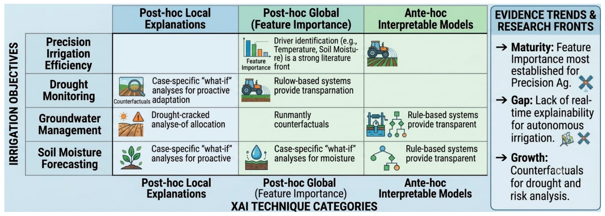
Variables such as land surface temperature, vegetation indices, and soil moisture have proven particularly valuable because they reflect different aspects of plant-water interactions. As illustrated in
Figure 5, explainable AI analyses consistently identify these variables as major contributors to irrigation recommendations, revealing the environmental factors that influence model decisions [
43]. Rather than functioning as isolated predictors, these variables collectively describe crop water status and the balance between water supply and atmospheric demand. A notable contribution of explainable AI is its ability to translate complex model outputs into information that can support operational decision-making. Feature attribution analyses reveal how irrigation recommendations change in response to environmental conditions such as crop growth stage, rainfall variability, atmospheric demand, and soil moisture availability. This information allows users to evaluate whether recommendations are consistent with agronomic expectations and to identify situations in which predictions may be associated with greater uncertainty. Such capabilities are particularly important for irrigation systems operating under highly variable climatic conditions.
Explainability has also strengthened the role of AI in drought monitoring and early warning applications. Several studies have shown that precipitation anomalies, vegetation stress indicators, and temperature-related variables consistently emerge as dominant predictors of drought conditions [
66]. By identifying the relative influence of these factors, explainable models provide insight into the progression of water stress and help distinguish short-term fluctuations from developing drought events. This information can support proactive management responses and improve preparedness for climate-related agricultural risks. Beyond field-scale irrigation decisions, explainable AI contributes to broader water resource management objectives. Improved understanding of the environmental drivers of water demand can support optimized allocation strategies, reduce unnecessary groundwater extraction, and enhance the sustainability of agricultural production systems. Consequently, explainability serves not only as a model interpretation tool but also as a mechanism for linking predictive analytics with practical water management decisions. Effective irrigation management depends not only on accurate predictions but also on understanding the factors that drive those predictions. Explainability methods reveal how land surface temperature, vegetation condition, soil moisture status, and precipitation variability contribute to irrigation recommendations [
42,
43,
66].
By quantifying the influence of these variables, decision-makers can distinguish between water stress caused by environmental conditions and that resulting from management practices. This information supports the evaluation of alternative irrigation strategies, helps identify situations associated with higher uncertainty, and improves the practical usability of AI-driven recommendations.
8. Explainable AI for Yield Prediction and Food Security
Crop yield forecasting is a cornerstone of agricultural planning because it links field-level production processes with broader food security, economic, and policy outcomes. Accurate estimates of crop productivity support decisions related to food supply management, market stabilization, crop insurance, trade planning, and climate adaptation [
67]. While conventional yield estimation approaches have traditionally relied on field measurements and statistical surveys, advances in remote sensing and artificial intelligence have enabled continuous monitoring of crop performance across large geographic areas.
The combination of deep learning with multitemporal satellite observations, climatic records, and soil information has substantially enhanced the ability to capture the complex interactions that influence agricultural productivity. Rather than relying on a single indicator, modern forecasting systems integrate information describing crop growth, environmental conditions, and resource availability throughout the growing season. This integrated perspective is particularly important because yield outcomes emerge from the cumulative effects of multiple processes operating over time. Explainability methods provide an opportunity to examine how these processes contribute to prediction outcomes. SHAP-based analyses have shown that cumulative rainfall, vegetation condition represented by NDVI, and growing degree days frequently exert strong influence on yield forecasts [
68]. These variables reflect fundamental controls on crop development, including water availability, photosynthetic activity, and thermal accumulation. Their consistent importance across different studies suggests that explainable models are capturing biologically meaningful relationships associated with biomass production and grain formation rather than relying solely on statistical correlations. The value of interpretability extends beyond prediction accuracy. By revealing the relative contribution of climatic, soil, and vegetation variables, explainable models help identify the factors limiting productivity in different agricultural environments. In some regions, water availability may dominate yield variability, whereas in others, temperature stress, soil constraints, or management practices may exert greater influence. Such distinctions are particularly important for designing targeted interventions and evaluating adaptation strategies under changing environmental conditions. Food security assessments also benefit from this capability because understanding the drivers of production variability is often as important as predicting production itself.
Explainable frameworks support the identification of vulnerable agricultural regions, improve the transparency of risk assessments, and provide evidence that can guide resource allocation and policy responses. Interpretable AI systems help connect environmental conditions, agricultural productivity, and food security outcomes within a coherent analytical framework [
69]. Agricultural productivity is shaped by the interaction of climatic conditions, vegetation development, soil resources, and management practices rather than by any single environmental variable. Rainfall availability, vegetation vigor, thermal accumulation, soil moisture, and soil fertility repeatedly emerge as dominant influences on yield performance because they directly regulate crop growth and resource use efficiency. The evidence summarized in
Figure 6 highlights how explainable AI can identify the relative importance of these factors, providing a clearer understanding of the environmental and management conditions that drive agricultural production and food security outcomes.
9. Explainable AI for Climate Change Adaptation and Carbon Monitoring
Climate change is reshaping agricultural systems through its effects on temperature regimes, precipitation patterns, water availability, soil conditions, and ecosystem processes [
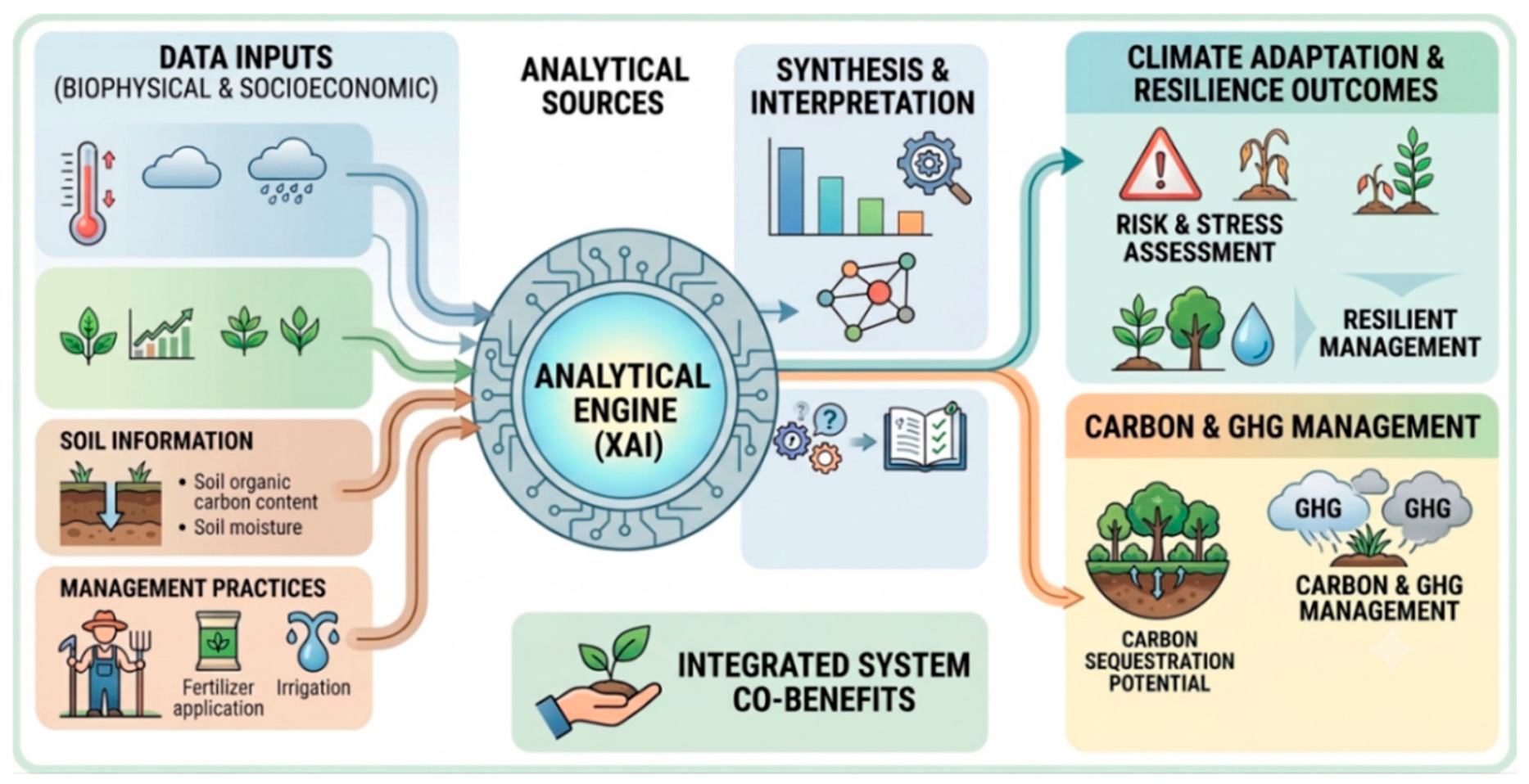
70]. These changes influence not only crop productivity but also the long-term sustainability and resilience of agricultural landscapes. Consequently, remote sensing and artificial intelligence have become increasingly important tools for monitoring environmental change, assessing climate-related risks, and supporting adaptation planning. As illustrated in
Figure 7, AI-driven monitoring frameworks can integrate information from satellite observations, weather records, soil datasets, and vegetation indicators to evaluate the vulnerability of agricultural systems under changing climatic conditions. A major advantage of these approaches lies in their ability to analyze multiple interacting environmental factors simultaneously.
Agricultural responses to climate change rarely result from a single stressor; instead, they emerge from the combined effects of temperature fluctuations, water availability, soil conditions, and ecosystem functioning. Explainable AI helps disentangle these interactions by identifying the variables that contribute most strongly to climate-related predictions. Temperature anomalies, precipitation variability, vegetation indices, and soil organic carbon frequently emerge as dominant explanatory factors because they collectively characterize both environmental stress and the capacity of agricultural systems to withstand that stress [
71].
The importance of vegetation indicators extends beyond crop monitoring alone. Indices such as NDVI and EVI provide information about the canopy condition, photosynthetic activity, and ecosystem response to climatic disturbances. Similarly, soil organic carbon serves as an indicator of soil health and ecological resilience because carbon-rich soils generally exhibit greater water-holding capacity, improved structure, and enhanced resistance to environmental stress. The repeated identification of these variables across different applications suggests that climate resilience depends on both current environmental conditions and the long-term capacity of ecosystems to buffer external disturbances. Explainable AI has also expanded the scope of agricultural carbon monitoring. Machine learning models are increasingly applied to estimate carbon sequestration, methane emissions from rice systems, and nitrous oxide emissions associated with agricultural management practices.
Interpretation methods help identify the environmental and management variables responsible for emission variability, providing insight into how land-use practices influence carbon dynamics. Such information is valuable for evaluating mitigation strategies including conservation agriculture, agroforestry, regenerative farming, and soil carbon enhancement programs. Droughts, heatwaves, and prolonged precipitation deficits represent some of the most significant threats to agricultural production. By identifying the factors that contribute most strongly to vulnerability assessments, explainable models support the development of early-warning systems and help prioritize adaptation measures in regions facing elevated climate risks. These capabilities strengthen the connection between environmental monitoring and practical decision-making in climate-smart agriculture.
10. Multi-Source Data Fusion and Interpretable Analytics
Modern agricultural monitoring increasingly depends on the ability to combine information from multiple sensing platforms operating at different spatial, temporal, and observational scales. No single data source can fully characterize the complexity of agricultural systems. Satellite imagery provides broad geographic coverage and long-term temporal records, UAV platforms offer detailed field-scale observations, IoT sensors capture continuous environmental measurements, and weather datasets provide essential climatic context. The integration of these complementary datasets has therefore become a central component of advanced agricultural intelligence systems designed to support monitoring, forecasting, and decision-making [
72,
73].
The primary challenge associated with multi-source data fusion is not the availability of information but the effective integration of heterogeneous data streams. Differences in spatial resolution, temporal frequency, sensor characteristics, and data quality can complicate model development and interpretation. As multimodal AI architectures become more sophisticated, understanding how individual data sources contribute to prediction outcomes becomes increasingly important. Explainable AI addresses this challenge by revealing the relative influence of different datasets and identifying the interactions that drive model behavior. Evidence from recent applications demonstrates that individual sensing modalities contribute distinct forms of information to agricultural monitoring systems [
74].
UAV imagery often provides the detailed spatial information needed to identify within-field variability, while satellite time series contribute consistent temporal observations that support seasonal monitoring and trend analysis. Weather datasets supply information on environmental forcing factors, whereas IoT networks capture localized measurements related to soil, crop, and atmospheric conditions. Rather than competing with one another, these data sources frequently provide complementary perspectives on the same agricultural processes. A further advantage of explainable data-fusion frameworks lies in their ability to address scale-related challenges. Agricultural phenomena often develop simultaneously at field, farm, regional, and seasonal scales. Explainability analyses help determine which observations are most informative at each scale and whether prediction outcomes are driven primarily by local conditions, broader environmental influences, or interactions between the two. This capability is particularly valuable for applications such as yield forecasting, drought assessment, disease monitoring, and precision management, where decisions depend on understanding both spatial variability and temporal dynamics.
The integration of temporal information represents another important dimension of multimodal analytics. Agricultural systems evolve continuously throughout the growing season, requiring models capable of combining historical observations with near-real-time monitoring data. Explainability methods can identify the periods that contribute most strongly to prediction outcomes and reveal whether models are responding to meaningful phenological transitions, environmental disturbances, or management interventions. Such insights improve both scientific interpretation and operational usability. Multi-source data fusion has also expanded opportunities for monitoring complex agricultural stresses. Thermal imagery may capture physiological responses to water stress, hyperspectral observations can reveal biochemical changes, SAR measurements provide structural information independent of cloud cover, and meteorological data describe the environmental conditions influencing crop development. Explainability methods help clarify how these diverse sources interact and determine the extent to which each sensing modality contributes to final predictions.
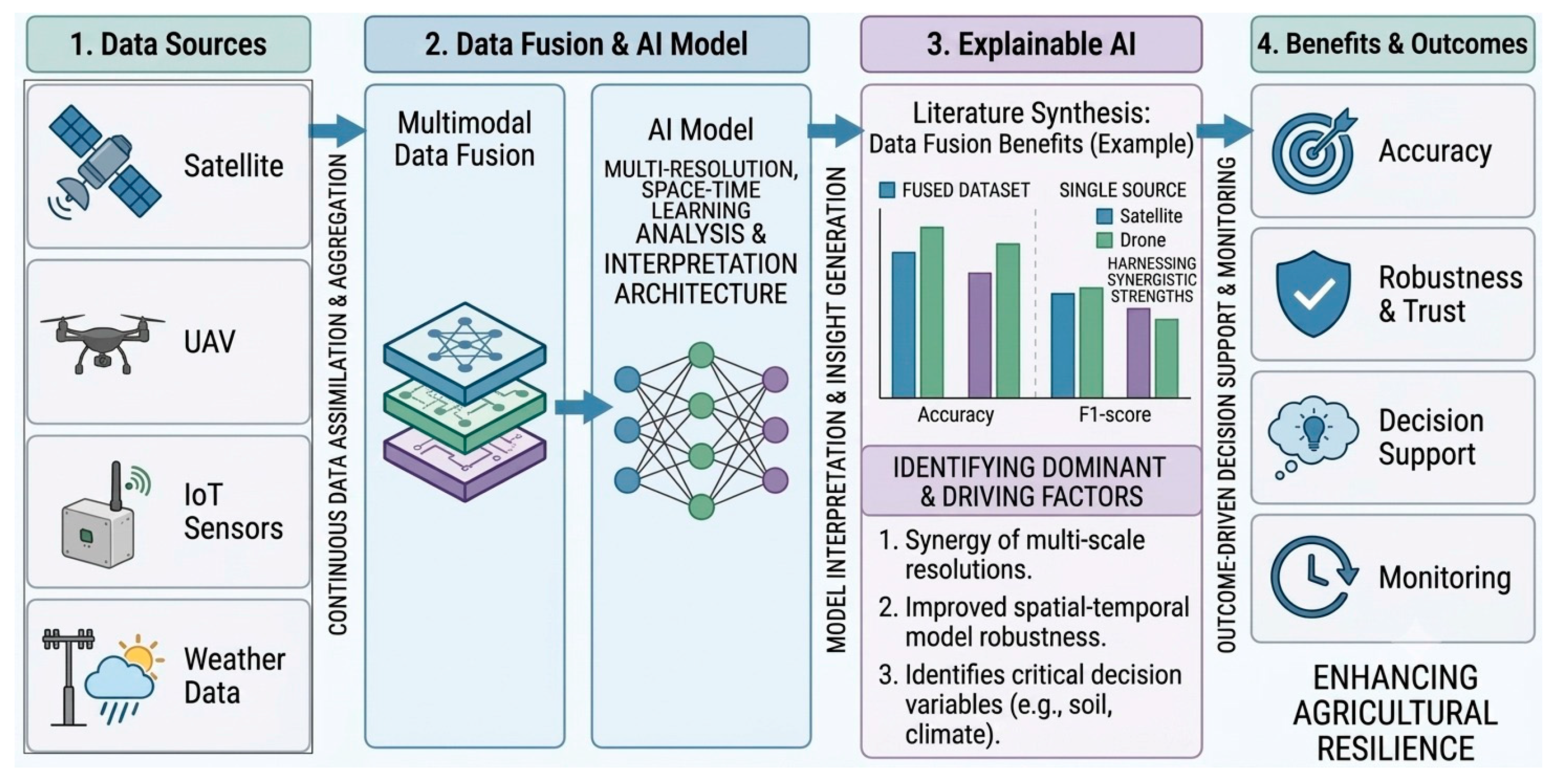
The value of multi-source data fusion arises from the complementary information provided by different sensing technologies rather than from any single dataset alone. Satellite imagery contributes regional coverage and temporal continuity, UAV observations provide high-resolution spatial detail, IoT sensors supply real-time environmental measurements, and weather datasets characterize climatic drivers of agricultural processes [
74]. The relationships among these data sources and their integration within agricultural intelligence systems are illustrated in
Figure 8. By quantifying the contribution of each information source, explainable AI enables more transparent, robust, and operationally effective decision-support systems for precision agriculture.
11. Ethical, Technical, and Operational Challenges
11.1. Data Heterogeneity
Agricultural datasets vary significantly in spatial resolution, temporal frequency, and quality [
75]. The increasing availability of multimodal remote sensing data, including satellite imagery, UAV observations, IoT measurements, and weather information, provides new opportunities for comprehensive agricultural monitoring. However, the integration of these heterogeneous data sources presents substantial challenges for explainability and model reproducibility. Agricultural remote sensing commonly integrates datasets acquired from multiple platforms with different acquisition times, spectral properties, and preprocessing requirements. Such variability may introduce inconsistencies that influence both predictive accuracy and explainability outcomes. For example, feature importance rankings obtained from optical imagery may differ considerably from those derived from SAR or hyperspectral data.
Temporal heterogeneity represents another major challenge because agricultural systems are highly dynamic. Crop growth stages, seasonal climatic variability, irrigation practices, and management interventions continuously modify spectral and environmental conditions. Consequently, explainable AI models trained for one season or region may not generalize effectively to other agroecological conditions. Differences in data quality and labeling also affect interpretability. In many agricultural applications, ground truth data are limited, imbalanced, or inconsistently collected. Such issues may introduce uncertainty into AI explanations and reduce confidence in operational recommendations. Forthcoming research should therefore prioritize standardized agricultural datasets, harmonized preprocessing frameworks, multimodal data-fusion strategies, and uncertainty-aware explainability approaches.
11.2. Computational Complexity
Advanced XAI methods may increase computational costs, particularly for large-scale remote sensing applications [
76]. Real-time explainability remains challenging for edge computing systems. As smart agriculture increasingly adopts IoT networks, autonomous machinery, and UAV-based monitoring platforms, there is growing demand for explainable AI systems that can operate efficiently under edge-computing constraints. Modern agricultural AI systems frequently process extremely large datasets composed of multitemporal satellite imagery, hyperspectral cubes, and high-resolution UAV observations. Deep learning architectures capable of handling such datasets often require substantial computational resources during both training and inference stages. The addition of explainability algorithms further increases processing complexity.
Methods such as SHAP and counterfactual analysis can become computationally expensive when applied to large geospatial datasets or transformer-based architectures. This limitation is particularly problematic for operational agricultural systems requiring near-real-time predictions, such as irrigation scheduling, pest outbreak forecasting, and drought early warning. Computational complexity also affects the accessibility of explainable AI technologies in developing regions where high-performance computing infrastructure may be limited. Lightweight and energy-efficient XAI frameworks are therefore needed to support practical deployment in resource-constrained agricultural environments.
Current advances in edge computing and model compression may partially address these challenges by enabling localized processing on UAVs, IoT devices, and autonomous agricultural machinery. However, balancing interpretability, computational efficiency, and predictive performance remains an active area of research.
11.3. Bias and Fairness
AI models may exhibit bias due to imbalanced datasets or regional variability [
77]. Explainability can help identify hidden biases and improve fairness. At the same time, uncertainty quantification is becoming increasingly important because agricultural predictions are often affected by environmental variability, measurement errors, and incomplete observations. Bias in agricultural AI systems may arise from multiple sources including unequal geographic representation, inconsistent field observations, sensor limitations, and socioeconomic disparities among farming systems. Models trained primarily on data from highly mechanized agricultural regions may perform poorly in smallholder farming environments or under different climatic conditions.
Explainable AI methods provide important tools for detecting such biases by revealing which variables dominate predictions and whether models rely on unrealistic correlations. For example, if a crop classification model consistently associates particular soil backgrounds with specific crop types regardless of vegetation characteristics, explainability analyses may expose this spurious relationship. Fairness is particularly important in agricultural decision-support systems linked to insurance, credit allocation, food security programs, and resource distribution. Biased AI recommendations could disproportionately affect vulnerable farming communities. Consequently, transparent explainability frameworks contribute not only to technical reliability but also to ethical and equitable agricultural management. In addition to bias detection, uncertainty-aware explainability can help distinguish between confident and uncertain model predictions. Such information is particularly valuable under extreme climatic conditions, rare events, and data-sparse agricultural environments where prediction reliability may be reduced.
Another concern involves algorithmic bias associated with temporal environmental variability. Extreme climatic events, droughts, and unusual growing conditions may produce data distributions different from historical training datasets. Explainable AI can help researchers identify situations where model predictions become unreliable or uncertain.
11.4. Human–AI Interaction
Effective agricultural AI systems require interpretable communication between humans and machines [
78]. Farmers and stakeholders may prefer visual explanations over mathematical representations. Consequently, future agricultural AI systems should increasingly adopt human-centered design principles that place user needs, transparency, and decision-support requirements at the core of system development. Human-centered AI has become increasingly important in precision agriculture because successful technology adoption depends not only on predictive accuracy but also on usability, transparency, and user trust. Agricultural stakeholders possess diverse educational backgrounds and technological experience; therefore, explainability interfaces must be adapted to different user groups.
Visual explainability approaches such as saliency maps, heatmaps, and interactive dashboards are often more intuitive for farmers than complex statistical metrics. These visualization tools allow users to identify stressed crop regions, disease hotspots, or irrigation deficiencies directly within spatial imagery. Such intuitive representations facilitate practical decision-making in real agricultural environments. Agronomists and agricultural engineers may require more advanced analytical explanations including uncertainty estimates, feature importance rankings, and causal interpretations. Consequently, explainable agricultural systems should support multiple levels of interpretability depending on user expertise and operational requirements. The importance of human–AI interaction becomes particularly evident in practical agricultural decision-making scenarios. For example, explainable yield forecasts may support crop insurance assessments and regional food security monitoring, while transparent drought predictions can improve irrigation allocation and water resource planning. Similarly, interpretable disease detection systems allow farmers to verify whether treatment recommendations are based on meaningful crop symptoms before implementing management actions. These considerations are especially important for smallholder farming systems, where limited access to alternative information sources may increase reliance on AI-generated recommendations. By providing understandable explanations of prediction outcomes, XAI can facilitate informed decision-making, strengthen user confidence, and encourage the integration of local agronomic knowledge into agricultural management practices.
Human–AI collaboration also involves feedback mechanisms in which users validate or correct AI predictions. Explainable frameworks improve this collaborative process by enabling stakeholders to understand why errors occur and how models can be improved. In the future, adaptive explainable systems may dynamically adjust explanations based on user preferences, cognitive load, and operational context, thereby supporting more effective human-centered agricultural decision-support systems.
11.5. Scalability and Generalization
Many explainable models are trained for specific crops or regions [
79]. Generalizing models across climates and agroecosystems remains difficult. Future progress in agricultural explainability will likely require closer integration between data-driven learning and established scientific knowledge. Physics-informed and process-aware AI approaches have the potential to incorporate agronomic, hydrological, ecological, and climatic mechanisms directly into model architectures, thereby improving both interpretability and generalization across diverse agricultural environments.
Agricultural environments vary substantially in terms of climate, soil properties, crop management, irrigation practices, and socioeconomic conditions. Consequently, AI systems trained under one set of environmental conditions may not perform reliably in different agroecological regions. This limitation affects both predictive performance and interpretability.
Scalability challenges become particularly important when applying explainable AI to continental or global agricultural monitoring systems. Models capable of interpreting field-scale imagery may encounter difficulties when extended to regional datasets characterized by lower spatial resolution and greater environmental variability. Likewise, models developed using controlled experimental conditions may lose reliability under real-world farming environments where noise, uncertainty, and management variability are substantially higher.
Generalization is further complicated by differences in crop phenology and seasonal dynamics. The spectral response associated with healthy vegetation in one climatic region may differ significantly from that observed under different environmental conditions. Explainable AI frameworks therefore need to account for spatial and temporal variability to ensure robust interpretation. Another important issue involves transferability across sensor platforms. Agricultural AI models are often optimized for specific satellite systems, UAV sensors, or imaging conditions. Variations in spectral bands, radiometric calibration, viewing geometry, and atmospheric effects may alter model behavior and influence explainability outcomes. Consequently, feature importance rankings and attention maps generated for one sensor system may not remain consistent when models are transferred to other platforms.
Scalability is also constrained by computational limitations associated with large-scale remote sensing analysis. Processing global or national agricultural datasets requires substantial storage capacity, cloud computing resources, and efficient model architectures. Explainability algorithms such as SHAP and saliency mapping may become computationally intensive when applied to high-dimensional geospatial datasets or transformer-based DL systems. The challenge of scalability extends beyond computational performance to operational usability. Farmers, agricultural engineers, and policymakers often require rapid and interpretable outputs that can support timely management decisions. Delays associated with complex explainability calculations may reduce the practical utility of AI systems in real-time agricultural operations.
Transfer learning, domain adaptation, and foundation models may improve scalability by enabling AI systems to adapt across regions and crop types. However, future research must also focus on developing explainability methods capable of maintaining transparency under highly diverse agricultural conditions. Emerging geospatial foundation models trained on massive Earth observation datasets may significantly improve the transferability of agricultural AI systems. These models can potentially capture generalized environmental patterns across multiple climatic regions and crop systems. Nevertheless, ensuring interpretability within large-scale foundation models remains a major scientific challenge because increasing model complexity often reduces transparency.
Federated learning approaches may also contribute to scalability by enabling collaborative agricultural AI training without centralized data sharing. Such approaches are particularly important in agriculture where data privacy, ownership, and regional restrictions may limit data accessibility. Integrating explainability within federated systems could improve trust and facilitate broader adoption of collaborative agricultural intelligence platforms. A distinction should be made between model interpretability and agronomic interpretability. A variable identified as important by an XAI method may not necessarily correspond to a meaningful agronomic process. Therefore, explanation outputs should be validated against established agronomic knowledge, field observations, experimental measurements, and expert assessments. Such validation is essential to ensure that model explanations represent genuine biological or environmental mechanisms rather than statistical artifacts. Integrating domain expertise with explainable AI can substantially improve the reliability and practical utility of agricultural decision-support systems.
Future research should prioritize the development of standardized evaluation protocols for explainability across different agroecosystems and sensor platforms. Benchmark datasets representing diverse climates, crop types, and management systems are needed to evaluate the robustness and transferability of explainable agricultural AI frameworks. The development of globally transferable explainable agricultural AI systems will likely require collaborative international datasets, standardized evaluation protocols, and integration of agronomic domain knowledge into model architectures, and physics-informed learning frameworks capable of combining mechanistic understanding with data-driven prediction.
12. Future Perspectives
Figure 9 illustrate that future research should focus on integrating XAI with geospatial foundation models, edge computing, digital twins, and autonomous agricultural robotics [
80]. Explainable multimodal AI systems may improve transparency in next-generation precision agriculture. Prospect research priorities can be broadly categorized into geospatial foundation models and physics-informed AI, multimodal remote sensing fusion, edge computing and autonomous systems, uncertainty-aware explainability, and human-centered agricultural decision-support systems [
81]. These emerging directions are expected to define the next generation of explainable agricultural intelligence. The future of explainable agricultural intelligence will likely depend on the convergence of remote sensing, AI, robotics, cloud computing, and environmental modeling within integrated digital ecosystems. Agricultural decision-support systems are expected to evolve from isolated predictive models toward continuously adaptive intelligent platforms capable of real-time environmental interpretation.
Geospatial foundation models trained on massive Earth observation datasets represent one of the most promising future directions. These large-scale AI architectures can capture generalized environmental patterns across diverse climates and agricultural systems. However, ensuring explainability within highly complex foundation models remains a major scientific challenge. Future research should therefore prioritize interpretable architectures capable of balancing predictive performance with transparency. In addition, integrating explainable AI with physics-informed and process-based modeling frameworks may improve scientific consistency by embedding agronomic, hydrological, and ecological knowledge directly into AI architectures. Such approaches have the potential to enhance both interpretability and model transferability across diverse agricultural environments. Digital twins are also expected to transform agricultural monitoring and management. A digital twin integrates real-time sensor observations, remote sensing imagery, simulation models, and AI analytics into a dynamic virtual representation of agricultural systems. Explainable AI within digital twins may enable transparent simulation of crop growth, irrigation responses, disease spread, and climate adaptation scenarios. The integration of multimodal remote sensing data, including satellite imagery, UAV observations, IoT measurements, weather information, and simulation outputs, represents another important research priority. Explainable multimodal frameworks may provide more comprehensive environmental understanding while maintaining transparency regarding the contribution of individual data sources. Autonomous agricultural robotics and edge AI systems are another rapidly emerging field. Smart tractors, robotic harvesters, autonomous drones, and sensor networks increasingly rely on AI-driven perception systems for navigation, crop monitoring, and targeted intervention. Explainability is essential in these applications because operational decisions must remain transparent, reliable, and safe under dynamic field conditions. Achieving real-time explainability on resource-constrained devices remains a major challenge. Future developments should focus on computationally efficient XAI methods suitable for edge deployment within autonomous agricultural systems and smart sensing networks. Future explainable AI systems are also expected to incorporate uncertainty quantification and probabilistic reasoning. Agricultural environments are inherently uncertain due to climatic variability, sensor noise, and biological complexity. Integrating uncertainty-aware explainability may improve confidence in AI predictions and support risk-informed decision-making. Uncertainty-aware explainability is expected to become increasingly important as agricultural AI systems are deployed under highly variable environmental conditions. Providing users with information regarding prediction confidence and uncertainty may improve trust and facilitate more robust decision-making. Another promising direction involves hybrid physics-informed AI models. These systems combine mechanistic agronomic knowledge with data-driven learning approaches. Explainable hybrid frameworks may improve scientific consistency while reducing dependence on purely empirical correlations. Human-centered explainability will become increasingly important as AI adoption expands among farmers, agricultural engineers, policymakers, and environmental agencies. Upcoming systems should provide adaptive explanation interfaces tailored to different user expertise levels and operational contexts. Human-centered explainability should remain a central design principle for future agricultural AI systems. Adaptive explanation interfaces that address the needs of farmers, agronomists, policymakers, and environmental managers may significantly improve technology adoption and operational effectiveness. Ethical and regulatory considerations are also expected to play a greater role in agricultural AI deployment. Transparent explainability frameworks may become necessary for compliance with emerging AI governance standards, environmental policies, and sustainable agriculture regulations. Collaborative international datasets and standardized benchmarking protocols are needed to improve the reproducibility and comparability of explainable agricultural AI research. Current studies often rely on region-specific datasets and inconsistent evaluation strategies, limiting scalability and operational transferability.
Future advances in explainable remote sensing may additionally support global sustainability initiatives including climate adaptation, carbon neutrality, biodiversity conservation, and food security assessment. Transparent AI systems could improve evidence-based policymaking and strengthen resilience within agricultural production systems. Interdisciplinary collaboration among agronomists, remote sensing scientists, AI researchers, soil scientists, hydrologists, and policymakers will be essential for developing robust and operational explainable agricultural intelligence systems. Such collaboration may significantly accelerate the transition toward sustainable and climate-resilient smart agriculture.
13. Conclusions
Explainable Artificial Intelligence is rapidly emerging as a transformative paradigm for smart agriculture and remote sensing analytics. While AI and deep learning models have achieved remarkable predictive performance in crop monitoring, soil assessment, irrigation management, climate adaptation, and yield forecasting, their black-box nature has limited transparency and stakeholder trust. XAI addresses these challenges by enabling interpretable, transparent, and accountable agricultural intelligence systems. This review demonstrated that explainability methods such as SHAP, LIME, Grad-CAM, saliency maps, attention mechanisms, and counterfactual analysis provide valuable insight into model behavior and feature importance. Interpretation of recent studies revealed that vegetation indices, thermal variables, precipitation, topography, and soil moisture consistently play dominant roles in agricultural predictions. The reviewed evidence further indicates that explainable AI improves decision reliability, facilitates stakeholder acceptance, and supports sustainable agricultural management. The integration of multi-source remote sensing data, UAV imagery, IoT sensing, and advanced AI architectures has significantly expanded the capabilities of precision agriculture. However, challenges related to scalability, computational complexity, uncertainty, fairness, ethics, and data heterogeneity remain major obstacles.
Future research should focus on hybrid explainability frameworks, human-centered AI, digital twins, edge intelligence, and climate-resilient agricultural systems. The combination of explainability and remote sensing will become increasingly important for sustainable food production, environmental conservation, and climate adaptation under rapidly changing global conditions.