Article

Photogrammetric Documentation of the Hittite ‘Spring of Nerik’, Oymaağaç Höyük (Türkiye)—How Different Data Products Can Be Derived from Image Series

1
Labor für Photogrammetrie, Fachbereich III, Berliner Hochschule für Technik (BHT), Luxemburger Str. 10, 13353 Berlin, Germany
2
Arkeoloji Bölümü, Fen-Edebiyat Fakültesi, Uşak Üniversitesi, Bir Eylül Kampüsü, 64200 Uşak, Türkiye
3
Abteilung für Ur- und Frühgeschichtliche Archäologie, Historisches Seminar, Universität Münster, Domplatz 20–22, 48149 Münster, Germany
*
Author to whom correspondence should be addressed.
Heritage 2025, 8(8), 322; https://doi.org/10.3390/heritage8080322
Submission received: 22 May 2025 / Revised: 4 August 2025 / Accepted: 6 August 2025 / Published: 12 August 2025

Abstract

The Oymaağaç Höyük Project (2005–today) investigates a 6,500-year-oldmulti-period settlement in the district of Vezirköprü at the southern edge of the Black Sea province of Samsun in northern Türkiye. According to cuneiform texts, the site can be associated with the Hittite cult city of Nerik (17th–12th century BC). Automatic multi-image photogrammetry, also known as Structure from Motion (SfM), has proven to be a powerful and flexible means for the three-dimensional documentation of objects and finds of different shapes and sizes. Data products were created in the form of 3D point clouds, textured surface models, orthophotos, sections, and 3D prints (physical 3D models). Visualization of 3D data was realized via an internet browser (Potree Viewer, Babylon.js) and virtual reality (VR) techniques. Photogrammetry is very flexible in its application because the accuracy depends essentially on the scale of the images. On the other hand, the constantly growing volume of data as a result of the evolving technical possibilities requires sustainable data management, which is difficult to realize in practice due to limited financial resources. The article provides an overview of the use of photogrammetry in the project.

1. Introduction

The Oymaağaç Höyük Project (2005–today) investigates a 6,500-year-oldmulti-period settlement in the district of Vezirköprü at the southern edge of the Black Sea province of Samsun in northern Türkiye. The modern city of Samsun is located ≈100 km east of Oymaağaç on the coast, while Oymaağaç lies inland ≈200 km north-east of the Hittite capital Hattuša (Figure 1). ‘Höyük’ means mound in Turkish, and spectacular archaeological finds came to light on this 2,5-hectare mound near the village of Oymaağaç. According to a number of cuneiform texts, the site can be associated with the Hittite cult city of Nerik (17th–12th century BC) on the northern periphery of the Hittite Empire. It is assumed that the Hittite kings were crowned here. One of the main tasks was the uncovering of a temple complex measuring 2,500 m2 on the top of Oymaağaç Höyük. The excavations revealed a city gate flanked by two big towers—the Temple of the Weather god, and his ‘beloved’ or ‘deep’ Spring of Nerik, which is associated with an underground spring chamber nearby the end of an underground staircase. This underground structure was carefully excavated between 2009 and 2019 and represents an exceptional masterpiece of Hittite engineering and architecture. In 2017 very well preserved waterlogged wood was discovered inside the spring chamber, which is an exceptional archaeological discovery, too. Photogrammetric documentation of these very different items was carried out by staff and students of the Photogrammetry Laboratory at Berlin University of Applied Sciences BHT, Germany (formerly Beuth University of Applied Sciences Berlin) in cooperation with FU Berlin, Germany (Institute of Ancient Near Eastern Studies) and Uşak Üniversitesi, Türkiye.

2. Materials and Methods

Although different methodologies such as hand-drawing, stereo-photogrammetry and terrestrial laserscanning were tested, automatic multi-image photogrammetry, also known as Structure from Motion (SfM), has proven to be the most powerful and flexible means for the three-dimensional documentation of objects of different shapes and sizes throughout the long course of the excavation. SfM means that the structure of an object is derived from images taken with a moving camera. Commercial (e.g., 3DF Zephyr, Agisoft Metashape, and RealityCapture) and non-commercial (e.g., Bundler with CMVS, COLMAP, and MicMac) software products are available for this purpose. The results presented in this paper were mainly generated using Metashape from Agisoft. There were also attempts at stereophotogrammetric recording and terrestrial laser scanning, which turned out to be less suitable due to the difficult working environment inside the underground structure. Furthermore, photogrammetry proved to be a fast and time-efficient method for recording the waterlogged wood. Additionally, the software ERDAS IMAGINE from Hexagon and Metashape from Agisoft were used in comparison to calculate an elevation model for the excavation site and its surroundings from stereoscopic Pléiades satellite data. The realization of a temporally stable and uniform local coordinate system was of great importance in order to be able to correctly classify the individual finds geometrically in their archaeological context. This had been realized in advance using geodetic methods. All data were related to this and could be assembled via post processing in the Photogrammetry Laboratory at BHT. A multitude of 3D models was combined and resulted in a comprehensive, three-dimensional documentation of the individual stages of the excavation at Oymaağaç Höyük. The underground structure and the finds of waterlogged wood to be documented are presented next before the photogrammetric process is discussed in more detail.

2.1. The Underground Structure

The Turkish archaeologist U. B. Alkım discovered the site of Oymaağaç Höyük. He was the first to report the existence of an underground structure. He suspected that there was a passageway, a so called ‘Poterne’ [1] (p. 7). The picture published by J. Yakar in 1980 was captured during an archaeological survey in the summer of 1975 [2] (p. 79). It shows the top of the corbelled vault near the collapsed entrance to the underground structure (Figure 2a). In the years that followed, the entrance was buried and was no longer visible. However, when it was rediscovered and completely cleared of sediment, it turned out that there was no passageway (Figure 2b). Instead, it is the entrance to a 29 m-long underground staircase that leads to a spring chamber 9 m below present surface, which archaeologists call the ‘Spring of Nerik’. At certain times, the sun shines directly into the underground, which might indicate the sacred character of the place (Figure 2c).

2.2. Finds of Waterlogged Wood

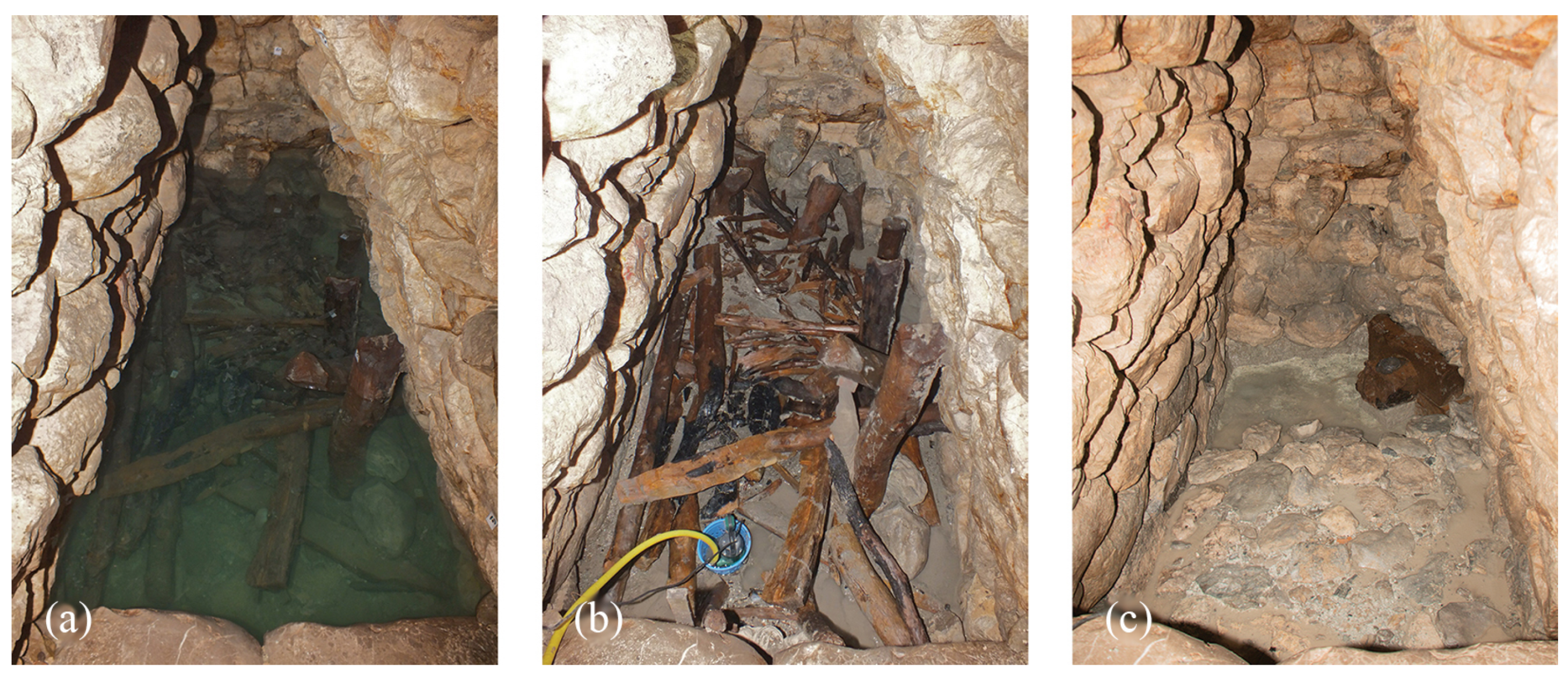
The excavation of the spring chamber began in 2017 and brought to light some spectacular finds. One of them was a wooden ladder, which was found in situ standing at the last step of the staircase and the beginning of the chamber (Figure 3). It has survived over 3,000 years thanks to the absence of oxygen [4]. In addition to the ladder, a large quantity of worked and unworked waterlogged wood (≈ 1,300 single pieces) was found in the chamber. Some pieces were burnt (Figure 4b). It is assumed that during the Iron Age in the 9th century BC, people set fire to the chamber in order to destroy it. The excavation was completed in 2019 [5]. That the complete construction, which dates back to the Hittite period, functioned as an artificial spring chamber is evidenced by an inlet in the form of a triangular gutter stone on the rear vertical wall and a wooden chest-sized installation for the controlled outlet in the rear right corner (Figure 4c). The complexity of some finds was challenging. Multi-image photogrammetry turned out to be the best suited method to document the exceptional underground structure and the waterlogged wood [6].

2.3. Photogrammetric Documentation

When the excavation of the underground staircase began in 2009, documentation was at first carried out using tape measures and hand drawings. This approach delivered good results [8] (Abb. 39, p. 53), but it proved to be inefficient due to the dimensions of the 29-meter-long, man-high structure and did not appear to be suitable for mapping the entire building. It was replaced by geodetic and photogrammetric methods in 2011. Different experiments led to the best solution for image capture. Normal and convergent stereo image configurations [9] (p. 155) were evaluated, including terrestrial laser scanning [10]. However, multi-image acquisition turned out to be more flexible and better suited for capturing the irregular surface of the underground staircase than any other approach. Photogrammetry was also used for the documentation of other finds, like the aforementioned ladder [11,12].

2.3.1. Multi-Image Acquisition

A typical configuration for image acquisition when the images are processed using the SfM method consists of images taken from different positions in space in different viewing directions. By doing so, each image yields a bundle of rays where a single ray connects an object point in space with its corresponding image point after it has passed the projection center. Rays of all images intersect at object points. The entirety of all beam bundles is referred to as a block of images or simply as a bundle block. Depending on the size of the object, hundreds of images may be taken in practice. The procedure is mathematically well described by collinearity equations that relate the three dimensional coordinates of a point in space (X, Y, Z) to its two dimensional coordinates in the sensor’s plane (x′, y′) [9] (p. 280). Today, all image processing is carried out using sophisticated algorithms. Using powerful hardware, a 3D model of the captured object can be created in a time span of a few hours. The accuracy is limited mainly by the size of a pixel at the object’s surface. So it is possible to reach millimeter accuracy.

2.3.2. SfM Workflow

A typical SfM workflow consists of the following steps:
  • Alignment (bundle adjustment and sparse point cloud);
  • Multi-View Stereo (dense point cloud);
  • 3D Meshing (surface model and texture).
During the first step, identical features are determined over all images by finding corresponding points. Solutions to this problem reference the SIFT-algorithm (scale invariant feature transform) published by D. G. Lowe in 1999 [13]. Here, descriptors of feature points are calculated from analyzing the local contrast of a feature point’s neighborhood in a way that image points of identical object features yield similar values. Hence, the descriptors are able to find identical points over a large series of images. Coded point signals are used to establish control points. These are points with given coordinates. They should be evenly distributed over the extent of the covered object to assure homogeneous accuracy. The SfM-Software automatically recognizes them, together with their identification numbers, provided that the diameter of the signal’s center point is covered by at least ten pixels. The control points are necessary to establish a well-defined relationship between the bundle block and the local coordinate system. Coordinates of control points are determined in the excavation’s geodetic coordinate reference system (object coordinate system). This was established by using total station measurements and GNSS. Bundle adjustment calculates the camera parameters (interior orientation), the position and facing direction of all of the images (exterior orientation), and the object coordinates of the feature points (sparse point cloud) [9] (p. 349). During the second step a dense point cloud is calculated using multi-view stereo algorithms. Such algorithms make use of the special properties of epipolar geometry of overlapping image pairs [9] (p. 411). As the third step, 3D meshing is applied on the points of the dense point cloud to model and texture the object’s surface [9] (p. 88). Figure 5 shows from left to right the series of images; the sparse point cloud; the dense point cloud; the 3D mesh; and the textured 3D mesh, which is the final 3D model.

2.3.3. Image Acquisition of the Underground Structure

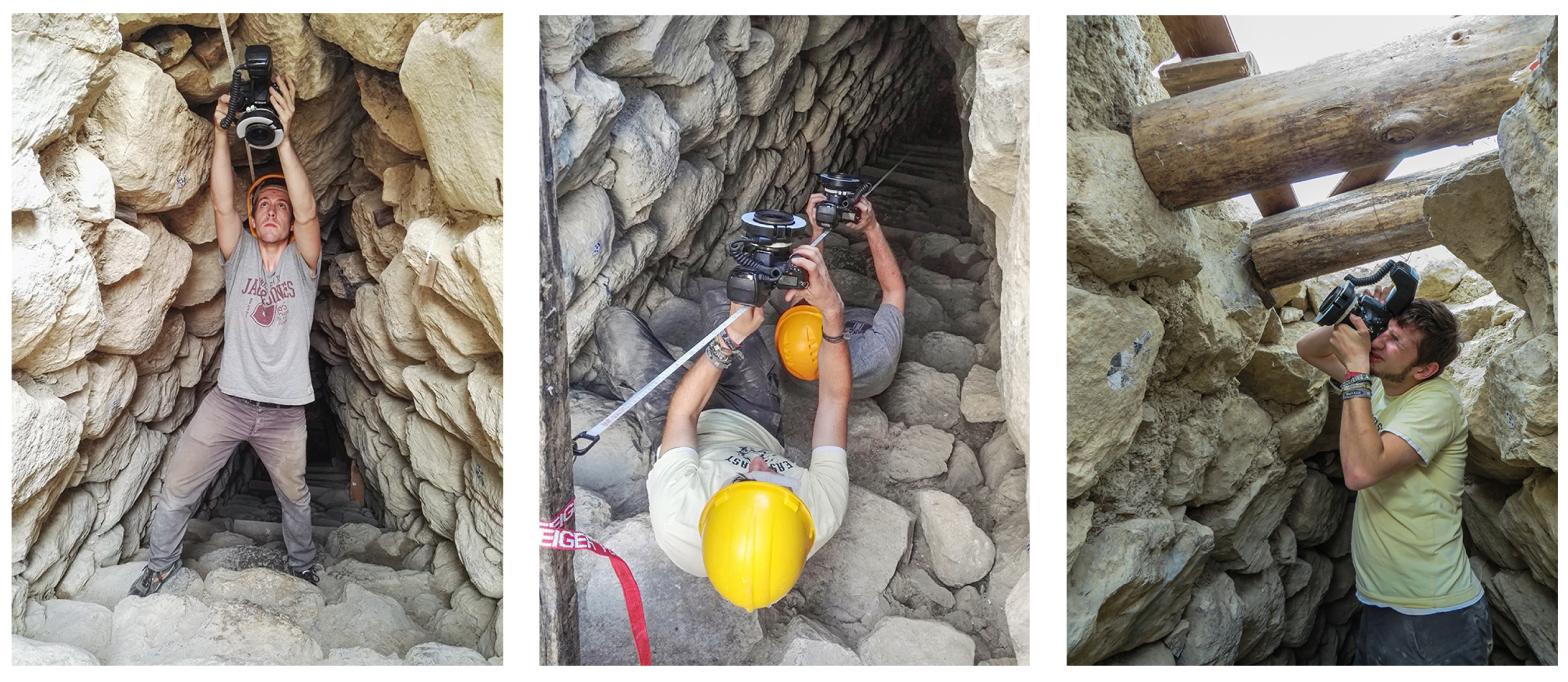
The recording of the underground structure had to be carried out in two stages. In 2016, the staircase, the cave, and the sondage were recorded (Figure 6). In preparation, a network of control points was established across the entire structure. The recordings, measurements, and analyses were carried out by BHT students, who were supervised by BHT staff members [14]. After the final excavation of the spring chamber in 2019, the documentation of the underground structure was finally completed. The results of the two phases were then combined in the laboratory to build an overall 3D model. In total, 7,977 images were taken and processed with the SfM software to generate the resulting 3D data set. Nikon D810 and D850 Full Frame DSLR cameras were used for image capturing.

2.3.4. Image Acquisition of the Waterlogged Wood

The exceptional find of the large amount of waterlogged wood in the spring chamber (Figure 4b) was a particular challenge not only for the excavation but also for the documentation. The wood was saturated by water and therefore very heavy (Figure 7a). At the same time, it was extremely fragile. It took more than a year to discover the most efficient approach to capture the waterlogged wood.
One idea was using a turntable to capture an object with three cameras from different positions. This was tried in 2018 (Figure 7b). However, most of the wood with lengths of up to 3 m was too large to be placed on it. Time efficiency was of particular importance as around 100 finds from the majority of the waterlogged wood had to be documented using photogrammetry due to their unique scientific significance. Based on the experiences made in 2018 and 2019, a movable trolley was designed for the 2022 campaign. The trolley holding three cameras (Figure 7c,d) was manually moved on rails, which resulted in a more expeditious capturing process. Thus, the waterlogged wood objects of special interest were first captured from one side and then turned around to be captured from the other side. To picture the two parts at the end, a special hold was used. The development and construction of the trolley and the hold are described in detail in a bachelor thesis written by H. Lux [15].

3. Results

3.1. Data Products

Numerous geodata products were created as part of the project, the most important of which are presented below. Beyond a topographic map and a elevation model, data products are available in the form of 3D point clouds, textured surface models, orthophotos, sections, and 3D prints (physical 3D models). With the aid of the Laboratory of Geomedia at BHT, visualization of 3D data was realized via an internet browser (Potree Viewer for large point clouds and Babylon.js for surface models). The data were also visualized, offering an immersive experience using recent virtual reality (VR) techniques. Hence, the excavation can also be virtually explored using VR glasses.

3.1.1. Topographic Map and Elevation Model

P. Breuer and T. Johannsen from the former Hochschule für Technik in Stuttgart completed a conventional topographic mapping campaign between 2005 and 2009 that resulted in a detailed topographic map of Oymaağaç Höyük with a scale of 1:500 [8] (p. 16). In addition, stereoscopic satellite imagery was used to map the topography of this site.

3.1.2. RGB Satellite Image of Oymaağaç-Vezirköprü, 2021

To map Oymaağaç Höyük and its surrounding area, a tri-stereo satellite scene from the Pléiades satellite system [16] (p. 133/134) was captured on 12 May 2021 with a resolution of 0.7 m and resampled to a ground sampling distance (GSD) of 0.5 m. The captured area had a size of 100 km2. Oymaağaç Höyük is located in the center of the satellite images surrounded by the mountainous landscape in the north of the administrative district of Vezirköprü. The data were purchased from GAF AG, Neustrelitz, Germany (www.gaf.de, accessed on 1 August 2025). The Pléiades satellite system was manufactured by Airbus Defence and Space (DS), Traufkirchen, Germany in cooperation with Centre National d’Études Spaciales (CNES), Paris, France and Thales Alenia Space (TAS), Cannes, France (https://cnes.fr/en/projects/pleiades, accessed on 1 August 2025).

3.1.3. Elevation Model of Oymaağaç-Vezirköprü, 2021

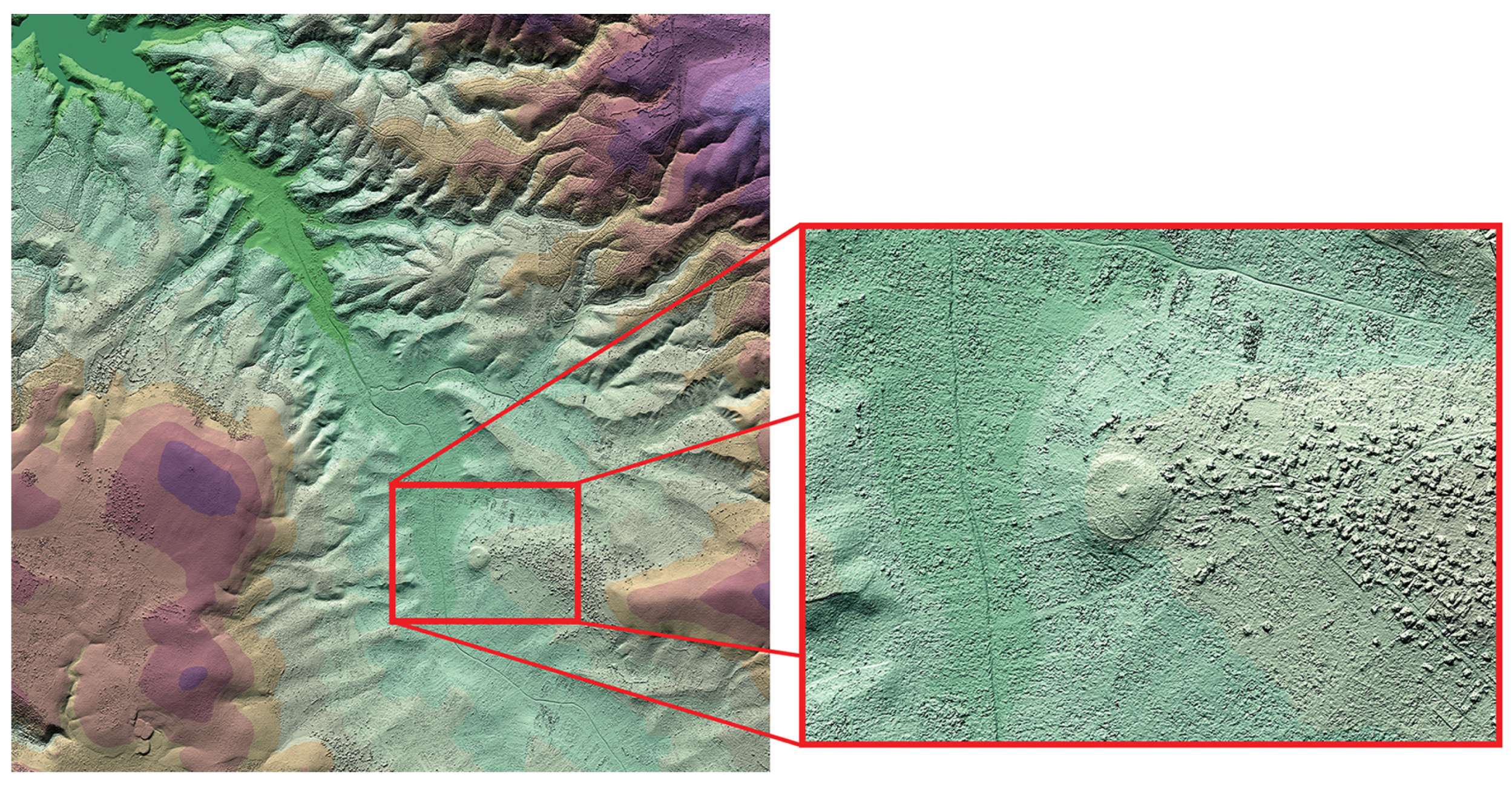
Additional to the RGB satellite image, an elevation model was calculated from the tri-stereo Pléiades satellite imagery using Agisoft Metashape. The result was artificially colored and visualized as a painted relief using ERDAS IMAGINE. The magnification in Figure 8 shows the shape of the mound with its neigbourhood. The village of Oymaağaç is visible east of the mound. Furthermore, Figure 8 shows a wider area that gives a good impression of the surrounding topography of Oymaağaç Höyük. The Kızılırmak reservoir is located in the top left-hand corner.

3.1.4. Photographic vs. Photogrammetric Documentation

Photography is widely used in archaeology as a fast means of documentation. But photographs have approximate scale only. In contrast, photogrammetry can provide complete 3D geometry on an accurate scale. A single photo is two-dimensional and less precise to scale than a photogrammetric product.

3.1.5. Synopsis of Excavations at Oymaağaç Höyük 2009–2019

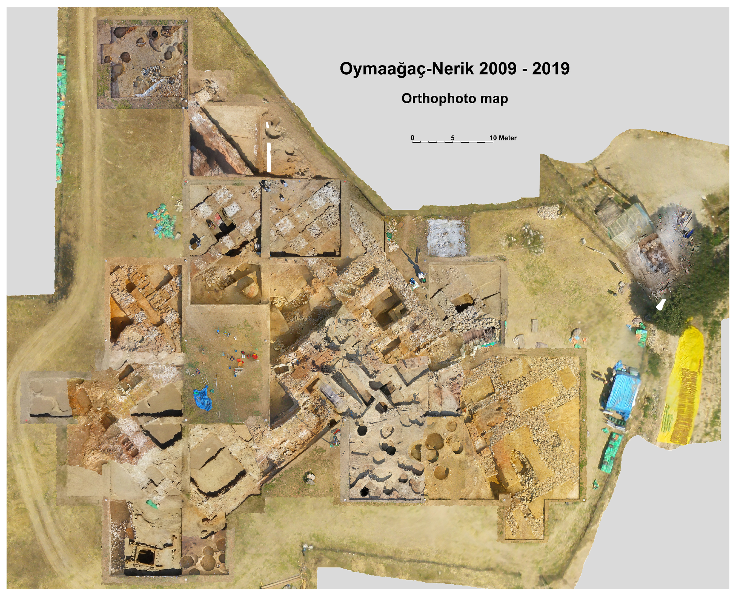
Different stages of the excavation process were consistently documented by photogrammetry. As a result, 3D models exist for each stratum. Based on the excavation’s coordinate system, they can be precisely combined to a synopsis. Figure 9 shows an orthophoto map of all open trenches as an example.

3.1.6. Visualization of 3D Content as VR

A virtual reality environment offers another possibility to visualize 3D data. In VR, one can safely explore the underground structure without being in Oymaağaç. This was realized using the software Unreal Engine. VR glasses from Meta (Oculus product line—Oculus Quest 2, 3) or HTC (Vive) can be used. Follow the link for an immersive experience:

3.1.7. Visualization of 3D Content via 3D PDF Using Adobe Acrobat

Adobe Acrobat Readers can display 3D data. A 3D PDF file is required for this. Download a file and save it on a computer’s hard drive. Then, open it with Acrobat Reader. Files can be downloaded via the following links (accessed on 1 August 2025):

3.1.8. Visualization of 3D Content via Web Browser Using Potree

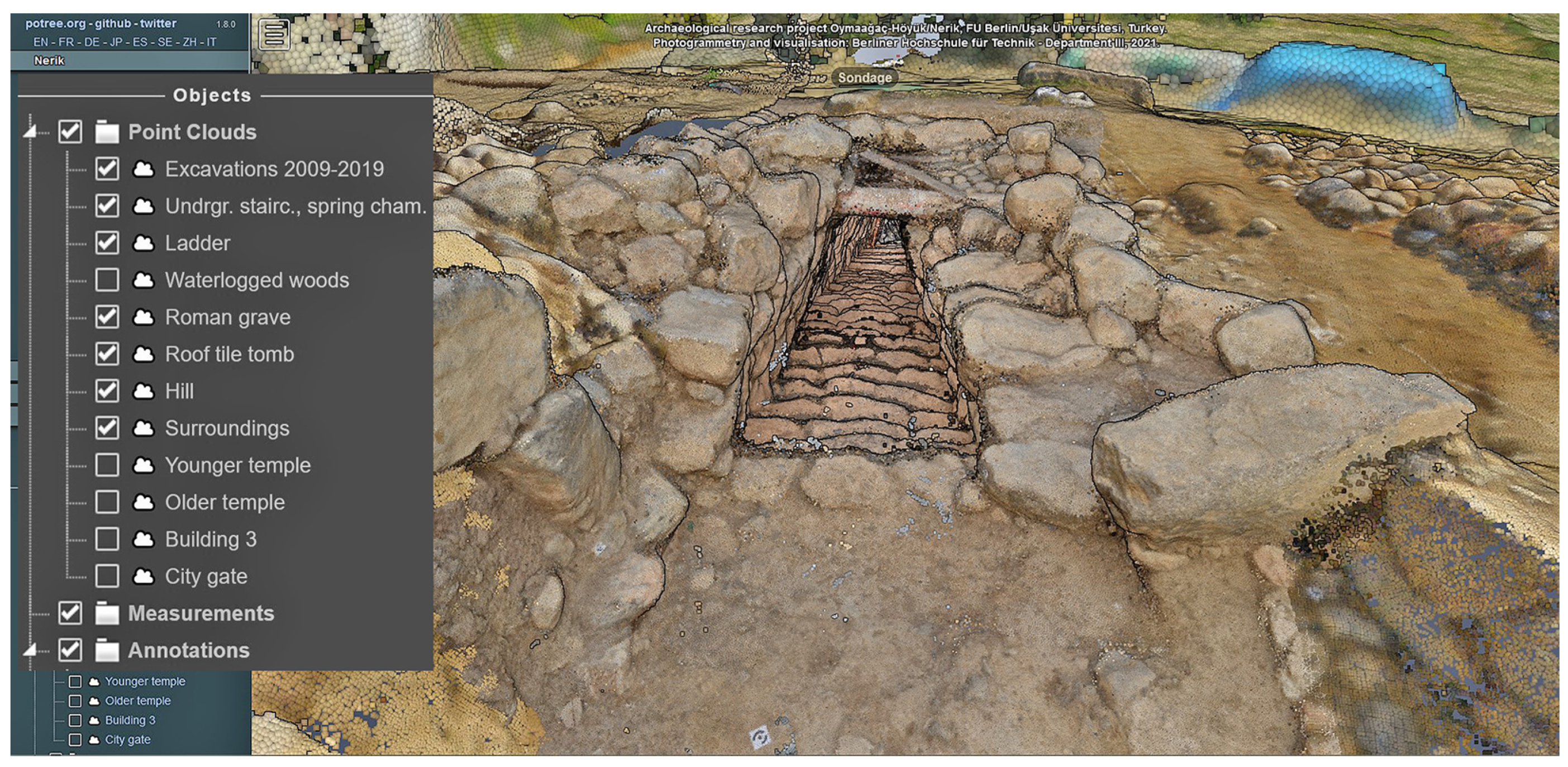
Potree is an open-source point cloud renderer (https://github.com/potree) based on WebGL (accessed on 1 August 2025). It was developed at TU Wien (Technical University Vienna, Austria) to display large 3D point clouds. The application proved to be very powerful in the visualization of very large amounts of data. Therefore, it was used in the Oymaağaç Höyük Project to offer a virtual guided tour. Users can select different layers and move around a 3D model of the excavation (Figure 10).

3.1.9. Visualization of 3D Content via Web Browser Using YouTube

Another possibility to explore the excavation is to watch a YouTube video (with explanations in German). The video can be accessed by the following link:

3.1.10. Visualization of 3D Content via Web Browser Using Babylon.js Viewer

The last tested option for publishing 3D data via a web browser is the Babylon.js viewer. In contrast to a 3D point cloud, the viewer shows a meshed and textured model. Although the model is already simplified, the performance is not satisfactory. The model can be displayed in two different resolutions. The quality of the display heavily depends on the performance of the computer used (both links accessed on 1 August 2025).

3.1.11. Section of the Underground Structure at Oymaağaç Höyük

Figure 11a shows a section of a textured 3D model of the underground structure. The staircase and the spring chamber are visible. The exploratory cut above the spring chamber was made primarily for safety reasons.

3.1.12. Visualization of 3D Content as Physical 3D Print

Digital 3D data of an object can be transformed into a physical 3D print using a 3D printer. Figure 11b shows a photo of a 3D print of the underground structure.

4. Discussion

The archaeological excavations at Oymaağaç Höyük provided an excellent opportunity to evaluate modern geodetic and photogrammetric surveying processes for the documentation of archaeological cultural heritage. However, the exceptional nature of the finds and findings from the underground spring of Nerik posed a major challenge, as it went far beyond the usual conditions of documenting archaeological structures and objects. The work benefited from continued technological progress over the years, which was particularly evident in software and hardware development and enabled ever smarter workflows and shorter processing times. It also showed the importance of good image capture planning. This includes geometric and logistical aspects. The accuracy that can be achieved with photogrammetry is dependent only on the image scale, meaning that it can be considered as a very flexible method. On the other hand, the ever-increasing amount of data resulting from the evolving technical possibilities require sustainable data management, which is difficult to realize in practice—often due to limited financial resources. Nevertheless, this is a very important point for the sustainable utilization of research results for which solutions must be found.

5. Conclusions

Shortly after the excavation of the underground structure had started in 2009, it became clear that the documentation of such a large and complex building structure was hardly practicable using conventional techniques (e.g., manual surveying). Photogrammetry has emerged to be a very good substitute for dealing with the documentation tasks. Furthermore, the unexpected discovery of the waterlogged wood posed additional challenges. This task was also successfully solved by using photogrammetry.

Author Contributions

Conceptualization, all; methodology, all; software, M.K., M.L.; validation, M.L., D.P.M.; formal analysis, D.P.M.; investigation, all; resources, all; data curation, all; writing original draft preparation, M.R.B.; writing review and editing, all; visualization, M.L., M.K.; supervision. R.M.C.; project administration, R.M.C., D.P.M.; funding acquisition, R.M.C., D.P.M. All authors have read and agreed to the published version of the manuscript.

Funding

This research was funded by the German Research Foundation (DFG), Gerda Henkel Foundation, Turkish Ministry of Culture and Tourism, Türk Tarih Kurumu, and Freie Universität Berlin.

Data Availability Statement

In addition to the information and links already mentioned in the text, further information and data on the Oymaağaç Höyük project are available on the following websites: the official website of the Oymaağaç Höyük Project https://www.nerik.de/; Berliner Hochschule für Technik (BHT), Labor für Photogrammetrie https://labor.bht-berlin.de/photogrammetrie/projekteaktivitaeten; Berliner Hochschule für Technik (BHT), Labor für Geomedien https://labor.bht-berlin.de/gem; and Deutsche Orient-Gesellschaft https://www.orient-gesellschaft.de/index.php (all links accessed on 1 August 2025).

Acknowledgments

Above all, the authors would like to thank the Turkish Ministry of Culture and Tourism, T. C. Kültür ve Turizm Bakanlığı, whose officials have continuously supported the project from the very beginning. Without this, the research results presented here could never have been realized. The authors also like to thank the following people for their contributions and help in completing the various tasks during the project. These are Mehmet Ali Yılmaz from Samsun Ondokuzmayıs Üniversitesi (Türkiye) and Jörg Klinger and Pavol Hnila from Freie Universität Berlin (Germany). At BHT, the project was initially led by Martin Kähler from the Laboratory of Photogrammetry and supported by the Laboratory for Geomedia. Further support came from the Laboratory for Geodetic Measurement. We thank all other people not mentioned here by name who made the project possible.

Conflicts of Interest

The authors declare no conflicts of interest.

Abbreviations

The following abbreviations are used in this manuscript:
BHTBerliner Hochschule für Technik
DSLRDigital Single Lens Reflex (Camera)
FU BerlinFreie Universität Berlin
GNSSGlobal Navigation Satellite System
SfMStructure from Motion
SIFTScale Invariant Feature Transform

References

  1. Arbeitsbericht der Kampagne 2006 (Rainer M. Czichon). Available online: www.nerik.de/downloads/Oymaagac%20-%20Kampagne%202006%20-%20Arbeitsbericht.pdf (accessed on 10 January 2025).
  2. Yakar, J. Recent Contributions to the Historical Geography of the Hittite Empire; Mitteilungen der Deutschen Orient Gesellschaft: Berlin, Germany, 1980; Volume 112, pp. 75–94. [Google Scholar]
  3. Mielke, D.P. Unterirdischer Treppengang und Quellkammer. In Archäologische Forschungen am Oymaağaç Höyük/Nerik 2016–2018; Mitteilungen der Deutschen Orient Gesellschaft: Berlin, Germany, 2019; Volume 151, pp. 135–155. [Google Scholar]
  4. Czichon, R.M.; Mielke, D.P. Nassholzfunde aus der unterirdischen Quellkammer. In Archäologische Forschungen am Oymaağaç Höyük/Nerik 2016–2018; Mitteilungen der Deutschen Orient Gesellschaft: Berlin, Germany, 2019; Volume 151, pp. 155–160. [Google Scholar]
  5. Mielke, D.P. Ausgrabungen in der unterirdischen Quellkammer. In Archäologische Forschungen am Oymaağaç Höyük/Nerik 2019; Czichon, R.M., Mielke, D.P., Eds.; Mitteilungen der Deutschen Orient Gesellschaft: Berlin, Germany, 2020; Volume 152, pp. 157–189. [Google Scholar]
  6. Czichon, R.M.; Mielke, D.P. Bearbeitung der Nassholzfunde aus der unterirdischen Quellkammer. In Czichon and Mielke; Archäologische Forschungen am Oymaağaç Höyük/Nerik 2019; Mitteilungen der Deutschen Orient Gesellschaft: Berlin, Germany, 2020; Volume 152, pp. 179–187. [Google Scholar]
  7. Breuer, M.; Czichon, R.M.; Koch, M.; Lehmann, M.; Mielke, D.P. Photogrammetrische 3D-Dokumentation von Nassholzfunden aus Oymaağaç Höyük/Nerik (Provinz Samsun/TR). Restaur. Archäol. 2017, 10, 47–62. [Google Scholar]
  8. Czichon, R.M.; Klinger, J.; Breuer, P.; Eerbeek, J.; Fox, S.; Marinowva-Wolff, E.; Marquardt, H.; von der Osten-Woldenburg, H.; Reichmuth, S.; Riehl, S.; et al. Archäologische Forschungen am Oymaağaç Höyük/Nerik (?) in den Jahren 2007–2010; Mitteilungen der Deutschen Orient Gesellschaft: Berlin, Germany, 2011; Volume 143, pp. 169–250. [Google Scholar]
  9. Luhmann, T.; Robson, S.; Kyle, S.; Boehm, J. Close-Range Photogrammetry and 3D Imaging, 3rd ed.; De Gruyter: Berlin, Germany; Boston, MA, USA, 2020; 822p. [Google Scholar]
  10. Kähler, M.; Lehmann, M. Photogrammetrie. In Archäologische Forschungen am Oymaağaç Höyük/Nerik 2011–2015; Mitteilungen der Deutschen Orient Gesellschaft: Berlin, Germany, 2016; Volume 148, pp. 121–127. [Google Scholar]
  11. Pergande, M. Dokumentation von Holzfunden am Oymaağaç Höyük durch 3D-Modellierung. Bachelor’s Thesis, Beuth Hochschule für Technik Berlin-University of Applied Sciences, Berlin, Germany, 8 August 2019. [Google Scholar]
  12. Breuer, M.; Lehmann, M.; Koch, M. Photogrammetrie. In Archäologische Forschungen am Oymaağaç Höyük/Nerik 2016–2018; Mitteilungen der Deutschen Orient Gesellschaft: Berlin, Germany, 2019; Volume 151, pp. 178–186. [Google Scholar]
  13. Lowe, D.G. Object Recognition from Local Scale-Invariant Features. In Proceedings of the Seventh IEEE International Conference on Computer Vision, Kerkyra, Greece, 20–27 September 1999; Volume 2, pp. 1150–1157. [Google Scholar]
  14. Schütze, M. Photogrammetrische Aufnahme eines Unterirdischen Ganges auf der Archäologischen Ausgrabung in Oymaağaç (Türkei). Bachelor’s Thesis, Beuth Hochschule für Technik Berlin-University of Applied Sciences, Berlin, Germany, 17 September 2017. [Google Scholar]
  15. Lux, H.F. Auswertung von Erfahrungen bei Entwicklung und Praktischem Einsatz eines Messwagens zur Photogrammetrischen Aufnahme von Nasshölzern. Bachelor’s Thesis, Berliner Hochschule für Technik-University of Applied Sciences, Berlin, Germany, 22 August 2024. [Google Scholar]
  16. Dowman, I.; Jacobsen, K.; Konecny, G.; Sandau, R. High Resolution Optical Satellite Imagery, 2nd ed.; Whittles Publishing: Dunbeath, UK, 2022; p. 271. [Google Scholar]
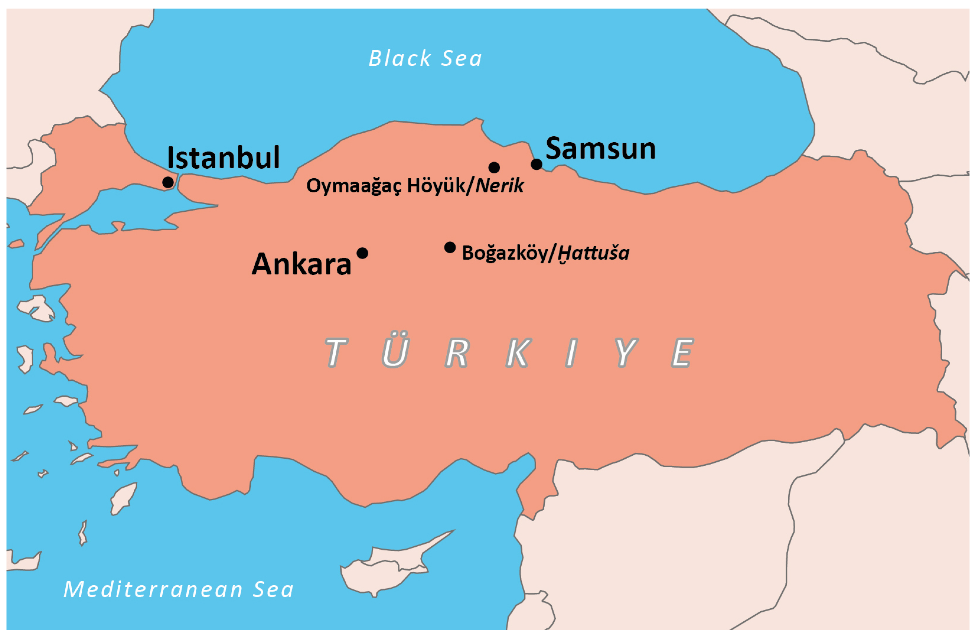
Figure 1. Republic of Türkiye. Graphic: N. Spiske-Salamanek and M. Lehmann.
Heritage 08 00322 g001
Figure 2. Underground structure. (a) ‘Oymaağaç-architectural remains from the second millenium BC.’ Photo from 1975 published by J. Yakar [2] (Figure 6, p. 82). (b) View towards the exit of the staircase 2016 [3] (Abb. 49). Photo: D. P. Mielke (c) Sunbeam lighting the entrance of the spring chamber, still filled with sediment 2016 [3] (Abb. 48). Photo: M. Lehmann.
Heritage 08 00322 g002
Figure 3. (a) Spring chamber with ladder in situ, 2017 [3] (Abb. 54). Photo: D. P. Mielke. (b) Image of the arrangement of the individual ladder fragments, 2017. [4] (Abb. 60). Photo: M. Koch.
Heritage 08 00322 g003
Figure 4. Spring chamber. (a) Wood finds covered with water, 2017 [3] (Abb. 58). (b) Wood finds after pumping out the water, 2017 [7] (Abb. 4). (c) Cleared out, with an approximate one-meter-wide wooden outlet at the rear end, 2019 [7] (Abb. 5). Photos: D. P. Mielke.
Heritage 08 00322 g004
Figure 5. SfM procedure. (a) Image series. (b) Sparse point cloud. (c) Dense point cloud. (d) 3D mesh. (e) Textured 3D model. Graphics: M. Lehmann.
Heritage 08 00322 g005
Figure 6. BHT students capturing images 2016. Photos: M. Koch.
Heritage 08 00322 g006
Figure 7. (a) Photogrammetric documentation of waterlogged wood, 2018 [7] (Abb. 8). Photo: M. Lehmann. (b) Geometric configuration of image capture using a turntable, 2018. Graphic: M. Koch. (c) Piece of wood on a table with control points and the movable trolley, 2022. Photo: H. Lux. (d) Top view of the center camera, 2018. Photo: A. Augustyn.
Heritage 08 00322 g007
Figure 8. Oymaağaç Höyük from space. Two sections of the digital elevation model calculated from Pléiades Tri-Stereo Satellite Imagery © CNES (2021), Distribution Airbus DS. Visualized as painted relief. Image data processing: H. Lux and M. Koch.
Heritage 08 00322 g008
Figure 9. Orthophoto map of excavations at Oymaağaç Höyük. Compilation: M. Lehmann.
Heritage 08 00322 g009
Figure 10. Entrance to the underground structure in Potree. Graphic: M. Lehmann.
Heritage 08 00322 g010
Figure 11. Underground structure at Oymaağaç Höyük. (a) Section of a textured 3D model, excavation status 2019. (b) Physical 3D print, excavation status 2017. Graphic and photo: M. Lehmann.
Heritage 08 00322 g011
Disclaimer/Publisher’s Note: The statements, opinions and data contained in all publications are solely those of the individual author(s) and contributor(s) and not of MDPI and/or the editor(s). MDPI and/or the editor(s) disclaim responsibility for any injury to people or property resulting from any ideas, methods, instructions or products referred to in the content.