Abstract
Beijing’s royal gardens represent the highest artistry in the artificial modification and utilization of natural hill and lake landforms. They also encompass the most concentrated ancient Chinese royal architectural heritage complexes. Their sustainable development has drawn significant attention, particularly in detecting and identifying areas of land subsidence and analyzing its influencing factors, which are crucial for preserving Beijing’s royal architectural heritage. This study employed time-series interferometric synthetic aperture radar (InSAR) technology to collect 148 SAR datasets from 2019 to 2023. It compares the persistent scatterer (PS)–InSAR and small baseline subset (SBAS)–InSAR techniques for cross-validation analyses to systematically assess the spatial characteristics of land subsidence of the most valuable architectural heritage complexes in the four most representative Beijing’s royal gardens. The study identified several areas with concentrated subsidence. Further analysis of the types of ancient building locations reveals that buildings situated in hilly areas (Type C), waterside buildings (Type A1), and near-water buildings (Type A2) are more significantly affected by land subsidence. Through an analysis of the causes of subsidence, it was found that, affected by the “excavating lakes and piling hills” landscape modification method and the utilization of natural hilled terrain approach, the subsidence observed in most Type C architectural heritage complexes within the study area may be associated with the Holocene sediments in the underlying soils beneath the shallow foundations of architectural heritage, localized bedrock instability caused by exposure and weathering, and slope instability. Type A building complexes’ subsidence and localized uplift may be associated with Holocene sediments beneath their foundations. The cross-comparison between SBAS-InSAR and PS-InSAR provides a reference framework for exploring land deformation research in architectural heritage sites where detection methods are constrained.
1. Introduction
Chinese gardens represent the artificial creation of a “second nature” within a defined area by utilizing and modifying natural hill and water forms combined with the arrangement of architectural complexes and other elements [1]. Beijing’s royal gardens represent the pinnacle of garden construction artistry in northern China and serve as the most well-preserved and concentrated area of ancient Chinese royal architectural heritage complexes, holding significant historical and cultural value [2]. The architectural heritage complex in Chinese gardens refers to a spatial system unit within the garden, centered around one or several main buildings, integrated with surrounding platforms, corridors, and other elements. Beijing’s royal gardens are mainly categorized into artificial hill–water gardens and natural hilly landscape gardens. The construction of artificial hill–water gardens often utilizes the “excavating lakes and piling hills” technique, where excavated lake sediment and other earth materials are used to build hills, creating a harmonious integration of water and landforms landscape. And the construction of natural hilly landscape gardens emphasizes adapting to the characteristics of the natural hilly area, utilizing the unique fundamental structures of hills—the shapes of rocks or the landform—for landscape creation. This garden construction approach has created unique and exquisite landscapes [1,2]. However, due to the foundations of architectural heritage complexes potentially being composed of excavated lake sediments or steep slopes [3,4], along with the influences of historical changes [5] and climatic environmental variations [6,7], the architectural heritage complexes within the gardens may face land stability issues. As a Beijing royal architectural heritage complex with a history of approximately 900 years, the spatial characteristics of land subsidence at its sites remain unclear [8,9,10,11].
In traditional survey methods for architectural heritage sites, subsidence detection is often conducted using sensors, 3D digital scanning technology, and other approaches, which have proven to be flexible [12,13]. However, manual inspections are labor-intensive, time-consuming, and prone to omissions [14]. Due to the lag in manual detection, protective measures are often implemented only after visible cracks have already appeared in the buildings, thereby increasing the difficulty and cost of restoration [15]. In contrast, interferometric synthetic aperture radar (InSAR) technology is a State-of-the-Art, non-invasive observation tool. InSAR enables precise measurement of land deformation by transmitting and receiving radar waves and calculating the phase differences between radar images acquired at different times or angles [16]. The monitoring accuracy of SAR images can reach a millimeter level in the vertical direction. Previous studies indicate a strong correlation between InSAR measurements and leveling values, with a root mean square error of approximately 1 mm/year [17,18,19]. The potential of remote sensing in cultural heritage has recently been highlighted, enabling near-real-time monitoring and assessment using quantitative indicators [20]. Regions with large architectural, cultural heritage complexes, such as Myanmar, Italy, and Sydney, have already utilized MTInSAR measurement technology to detect areas of long-term, slow land deformation [21,22,23,24].
In this study, we introduced the multi-temporal InSAR (MTInSAR) detection method into Chinese gardens for the first time to monitor subsidence sites within the architectural heritage complexes. The derived InSAR products (annual deformation rates and displacement time series) identified subsidence areas within the architectural heritage complexes of Beijing’s royal gardens. This paper explains the spatial distribution of subsidence areas, having found that while the artificial modification or utilization of hill and water environments creates unique landscapes, it may also lead to land deformation under environmental factors, such as intense rainfall and freeze–thaw phenomenon. The results demonstrate that remote sensing methods can detect the distribution and deformation trends of subsidence areas in heritage sites, particularly in situations where traditional methods, such as field accessibility and monitoring, are limited.
2. Study Area and Collected Data
2.1. Target Area of Research
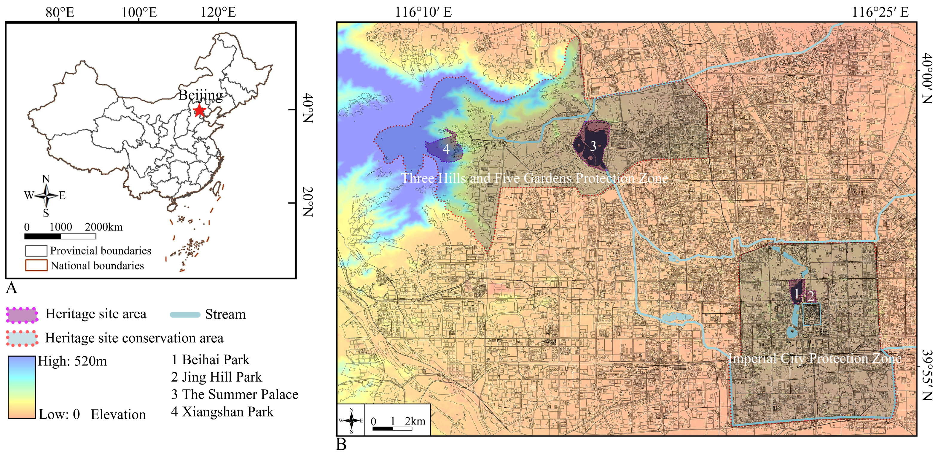
This study focuses on the architectural heritage complexes within four of the most representative royal gardens in Beijing. These include Beihai Park (0.71 km2), which is an artificial hill–water garden; Jing Hill Park (0.23 km2), which is an artificial hilly landscape garden within the “Imperial City Protection Zone” of Xicheng District; Summer Palace (2.97 km2), which is natural hill–water garden; and Xiangshan Park (1.60 km2), which is natural hilly landscape garden within the “Three Hills and Five Gardens Protection Zone” in Haidian District (Figure 1).
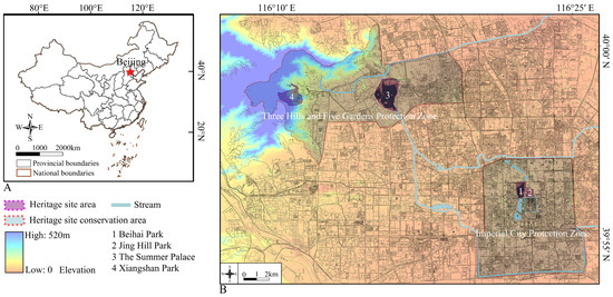
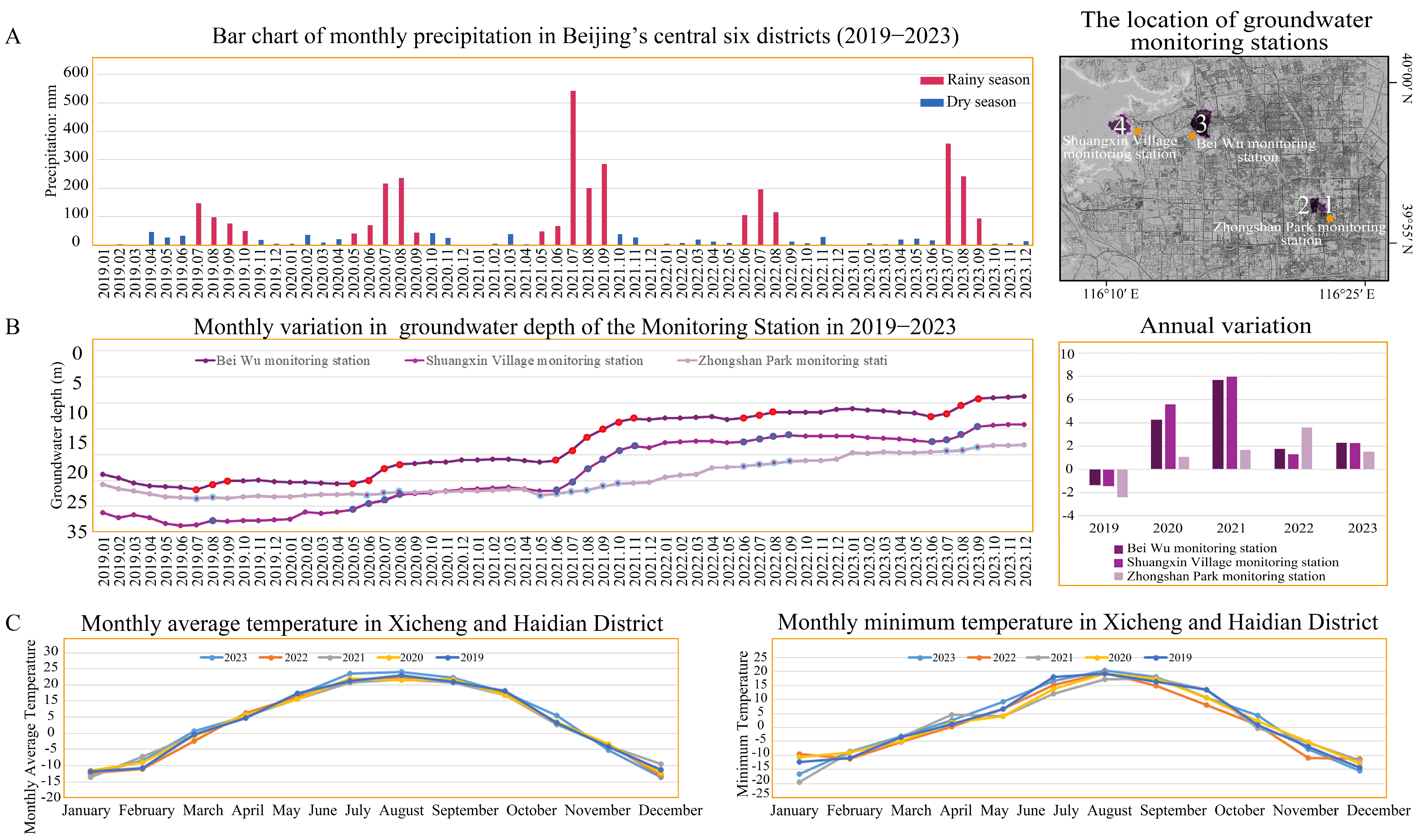
Figure 1.
(A) The location of Beijing in China. (B) Geographical distribution of 4 royal gardens in Beijing.
These four gardens, established around 1159, are among Beijing’s best-preserved architectural heritage sites. The areas where the traditional gardens are located are predominantly composed of sandy loam, sand, and gravel [25]. Beijing has a temperate monsoon climate characterized by hot and rainy summers [26]. Precipitation is concentrated between June and September, with summer rainfall accounting for approximately 70% to 80% of the annual total, leading to high humidity during this period. In contrast, the rest of the year experiences relatively low precipitation, with winter being particularly cold and dry, exhibiting distinct arid conditions (Figure 2A). During the rainy season, groundwater levels rise significantly. In other seasons, they either decline slowly, remain stable, or slightly increase (Figure 2B). Beijing’s extreme minimum winter temperature can reach −20 °C, with a seasonal frozen soil period of approximately 100 days. The typical frost depth ranges from 0.5 to 1.0 m [27], and the thawing period occurs between March and April each year (Figure 2C).
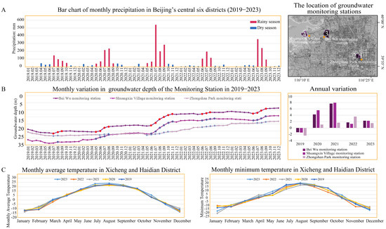
Figure 2.
(A) Monthly precipitation in Beijing’s central six central districts in 2019–2023. (B) Groundwater depth changes of the monitoring stations in 2019–2023. (C) Monthly average temperature and minimum temperature in Xicheng and Haidian Districts.
The ancient building complexes within Beijing’s royal gardens are regarded as the highest exemplars of Chinese royal architectural artistry, showcasing the exceptional design and craftsmanship of ancient Chinese royal architecture [28]. The main buildings within these traditional building complexes primarily adopt a timber-framed structural system, utilizing earth, wood, bricks, tiles, and stone as the main construction materials. The overall foundation of the building complexes is relatively shallow [29]. Influenced by traditional Chinese feng shui principles, hills and water are essential garden elements. The gardens contain natural or artificially constructed hills, with artificial hills often formed by piling up dredged sediment from lake excavation. Natural hills are either steep and rugged or integrated with rock formations to create scenic landscapes. Most garden water bodies are shaped by modifying natural swamps and lakes. Thus, the naming of ancient buildings is often closely associated with these hill and water features, such as “Xie by the water”, “boat Fang”, and “hillside Pavilion” [30]. Based on the location distribution types within the gardens, this paper categorizes ancient buildings in Beihai Park, Jing Hill Park, the Summer Palace, and Xiangshan Park into four types:
- Waterside buildings: Defined as buildings adjacent to water, with parts of the structure, such as platforms and walls, in contact with the water (Figure 3a);
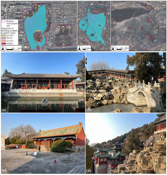 Figure 3. Classification of the surveyed buildings according to distribution location: (a) waterside building complex; (b) near-water building complex; (c) building complex on gentle slopes; and (d) building complex in hilly areas.
 - Near-water buildings: Defined as buildings within the protected area of a lake. According to Beijing’s standards for the management and protection of small rivers and lakes, to ensure water and ecological safety, the water environment protection range for the banks of Kunming Lake at the Summer Palace extends 20 m from the 20-year flood line; in Beihai Park, it extends 20 m from the regular water level line and 5 m from the island perimeter (Figure 3b);
- Buildings on gentle slopes: Defined as buildings situated on terrain with a slope below 6°. According to terrain slope grading standards, the layout of buildings in areas with a slope value below 6° is not restricted by topography (Figure 3c);
- Buildings in hilly areas: Defined as buildings situated on terrain with a slope value above 6°. The topography constrains buildings in the layout of these areas (Figure 3d).
2.2. Data Acquisition
To investigate surface subsidence phenomena at Beijing’s royal architectural heritage sites, 148 SAR Sentinel-1A interferometric wide swath (IW) Single Look Complex (SLC) data with HH polarization were acquired by the European Space Agency satellite along the ascending orbit from January 2019 to December 2023 (Table S1). Shuttle Radar Topography Mission (SRTM)1 data were used to simulate the topography phase, which was primarily measured jointly by NASA and the Department of Defense’s National Imagery and Mapping Agency (NIMA) at a spatial resolution of 30 m. Furthermore, precise orbit ephemeris (POE) was employed to correct Sentinel-1A satellite orbital altitude information.
3. Methods
3.1. PS-InSAR Technique
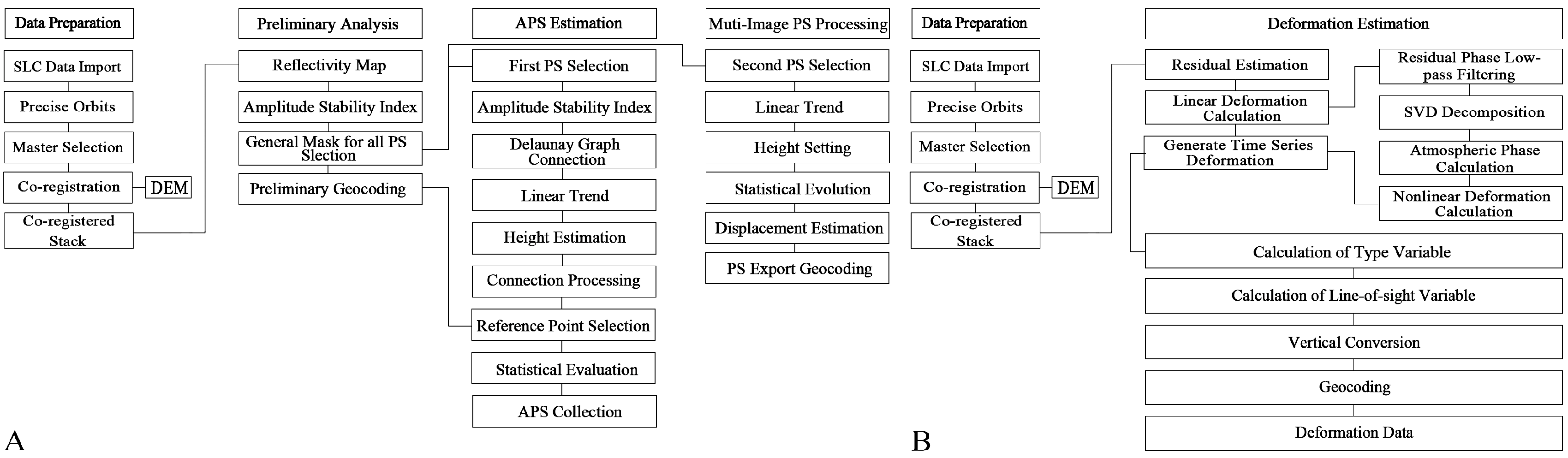
The InSAR technique acquires land deformation information using phase data from SAR [31]. The PS-InSAR technique automatically selects a single master image from multiple SAR images covering the same area, establishes master–slave relationships for all images based on a baseline threshold, and registers the data along this master image. The primary factors influencing interferogram coherence include temporal baseline, spatial perpendicular baseline, and Doppler centroid frequency baseline data. The acquisition time of the common master image should ideally be near the midpoint of the entire time series to minimize the effects of temporal decorrelation. The distribution of acquisition times across the image set should be as uniform as possible to avoid temporal gaps. Although PS-InSAR technology can handle interferometric pairs with long spatial baselines, even exceeding the critical baseline, smaller spatial baselines should still be prioritized to improve precision. For the generated interferogram set, keeping most spatial baselines within 300 m is recommended. When the Doppler centroid frequency baseline between two SAR images exceeds the azimuthal bandwidth, interferograms cannot be formed, as the radar bandwidth is fixed. Therefore, the Doppler centroid frequencies of the two SAR images should be as similar as possible. The optimized selection method is based on three baselines, and the minimum criteria involve calculating the sum of the temporal baseline, spatial perpendicular baseline, and Doppler centroid frequency baseline for all interferograms generated with each image as the common master. The image with the smallest baseline sum is then selected as the standard master image [32].
This study utilized GAMMA software (version 20241201) and selected data from 4 October as the master image. Figure 4A presents the spatial and temporal baseline plots of SAR images obtained from PS-InSAR. The horizontal axis represents the temporal baseline; the vertical axis represents the perpendicular baseline. Specifically, the perpendicular baseline refers to the component of the SAR spatial baseline, which is the distance between the two antennas in the SAR system. The perpendicular baseline is the projection of the actual baseline onto a plane perpendicular to the radar line of sight within the flight track plane; each point represents an individual SAR image (Table S1). The time baseline value indicates the time interval between two images, and the spatial baseline value indicates the distance difference between images acquired by the same satellite over the same area at different times [32].
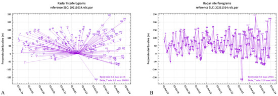
Figure 4.
The spatial and temporal baseline plots of SAR images from (A) PS-InSAR data and (B) SBAS-InSAR data.
Subsequently, interferometric processing was performed on each image pair according to the connection relationship of the image pairs to obtain time-series difference interference maps. By screening PS, whose phase and amplitude values remain stable over a consecutive period, excluding atmospheric effects, the phase characteristics of PSs were determined through modeling and calculations to inversely determine subsidence patterns at a certain period [33].
Considering the effects of atmospheric insulation correlation and elevation errors, the differential interference phase of each PS can be expressed as
where Δφ is the differential phase, Δφdef is the surface deformation phase, Δφtopo is the topography phase formed by DEM errors, Δφatm is the error phase driven by atmospheric delays, and Δφnoise contains error phases caused by thermal noise and decorrelation [34].
Δφ = Δφdef + Δφtopo + Δφatm + Δφnoise
The solution of land deformation phases must remove the topography, atmospheric delay, and noise phases to ensure computational accuracy. The topographic phase can be removed using DEM data [35]. Therefore, Equation (1) can be expanded as
where λ is the radar wavelength, T is the time baseline, Δv is the linear parameter to be determined, B is the perpendicular baseline, R is the slant distance, θ is the angle of incidence and Δh residual terrain height to be acquired, and ΔDnon-linear represents the phase due to non-linear deformation [33]. After removing the topographic phase, the remaining phase can be expressed as follows:
The commonly used target PS selection methods include the amplitude difference index threshold method and phase analysis. To utilize the high signal-to-noise ratio of PSs and improve the reliability of PS selection, this study used the amplitude difference index threshold method. This equation is expressed as follows:
where DA is the amplitude difference index, σA is the standard deviation of the amplitude, and mA is the mean amplitude [30]. The SAR data were registered, after which the amplitude value of each pixel element in the image set was calculated. Then, the amplitude mean value mA and standard deviation σA of each pixel were calculated according to the amplitude difference index values, thus calculating the amplitude–difference index value DA, which was compared to the given threshold DA, excluding the image point values higher than the threshold. The image point value that was lower than the threshold was thus selected as the PS point. Since the study focuses on Beijing’s royal architectural heritage complex, including ancient buildings, interconnected courtyards, and the surrounding rock formations, an amplitude dispersion value threshold of 0.25 was set to ensure the selection of a sufficient number of high-quality PS points within the study area. The temporal coherence of the selected PS points was then calculated:
where γt represents temporal coherence, N is the total number of SAR images, φi is the phase value of a pixel in the ith interferogram, and represents the unit complex form of the phase. This formula essentially accumulates the phase information of the point across all interferograms and takes its modulus, reflecting the phase consistency of the PS point in the time series. Higher coherence values (closer to 1) indicate more stable phase variations, signifying better data quality [36]. This study selected high-coherence PS points with a temporal coherence greater than 0.7 for the final deformation analysis. Figure 5A illustrates the overall data processing workflow based on PS-InSAR technology.
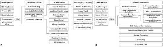
Figure 5.
The data processing workflow of (A) PS-InSAR and (B) SBAS-InSAR.
3.2. SBAS-InSAR Technique
The SBAS-InSAR technique integrates SAR data into a compact baseline set according to spatial and temporal thresholds to shorten the baselines of the data within each subset [37]. It automatically selects multiple master images as reference, with all pairs registered to the super master image to remove low-coherence pairs. The SBAS method compensates for the incoherence of the PS-InSAR technique using a single super master image [38]. This study set a maximum temporal baseline of 60 days and a maximum perpendicular baseline of 300 m, generating 614 interference pairs. Figure 4B presents the spatial and temporal baseline plots of SAR images obtained from SBAS-InSAR. The least-squares method was used to compute each subset, and singular value decomposition (SVD) was used to process the data between each subset.
This study assumes that the total number of SAR images is N + 1, with imaging times (t0, t1, …, tn), where j is a certain unwrapped differential map. Expressing the unwrapping phase of an image (x, r) is calculated as:
where (x,r) is the topography phase, (x,r) is the surface deformation phase, (x,r) is the error phase generated by atmospheric delays, and (x,r) contains error phases triggered by thermal noise or decorrelation [39].
In chronological order, one image was selected as the super master image while registering the rest. The short-baseline interferometric combination was satisfied to generate M-amplitude difference interference maps:
and the least-squares method or singular value decomposition for the M unwrapping phases is:
where A is a coefficient matrix of M × N; and φ(x, r) is the matrix consisting of the unknown deformation phases corresponding to the (x, r) point at N moments [40].
δφ(x,r) = Aφ(x,r)
When M ≥ N, it follows the least-squares methods that
when M < N, the equation has an infinite number of solutions, and cumulative deformations corresponding to different moments can be obtained by jointly solving multiple small baselines using the SVD method [37,39]. Figure 5B illustrates the overall data processing workflow based on SBAS-InSAR technology.
φ(x,r) = (ATA)−1ATδφ(x,r)
To ensure the reliability of the deformation inversion, this study employed the average coherence threshold and the temporal coherence threshold as selection criteria for coherent targets (CTs). Average coherence is one of the key indicators in the small baseline subset (SBAS) method for identifying coherent targets (CTs). It measures the overall coherence level of a pixel across multiple interferograms:
where represents the average coherence of a pixel over the entire time series, K is the total number of interferograms in which the pixel participates, and is the coherence of the pixel in the kth interferogram [37]. This study removed pixels with an average coherence below the threshold of 0.3 to eliminate low-coherence areas significantly affected by noise, such as densely vegetated regions and water bodies. This ensures that the selected targets maintain high spatial coherence across multiple interferograms. For further filtering, a temporal coherence threshold of 0.3 was applied as the selection criterion for coherent targets (CTs). This step removes pixels with unstable phase variations in the time series while ensuring enough coherent targets across a large spatial extent.
4. Results and Discussion
4.1. Comparison of the Land Subsidence Monitoring Results of PS-InSAR and SBAS-InSAR
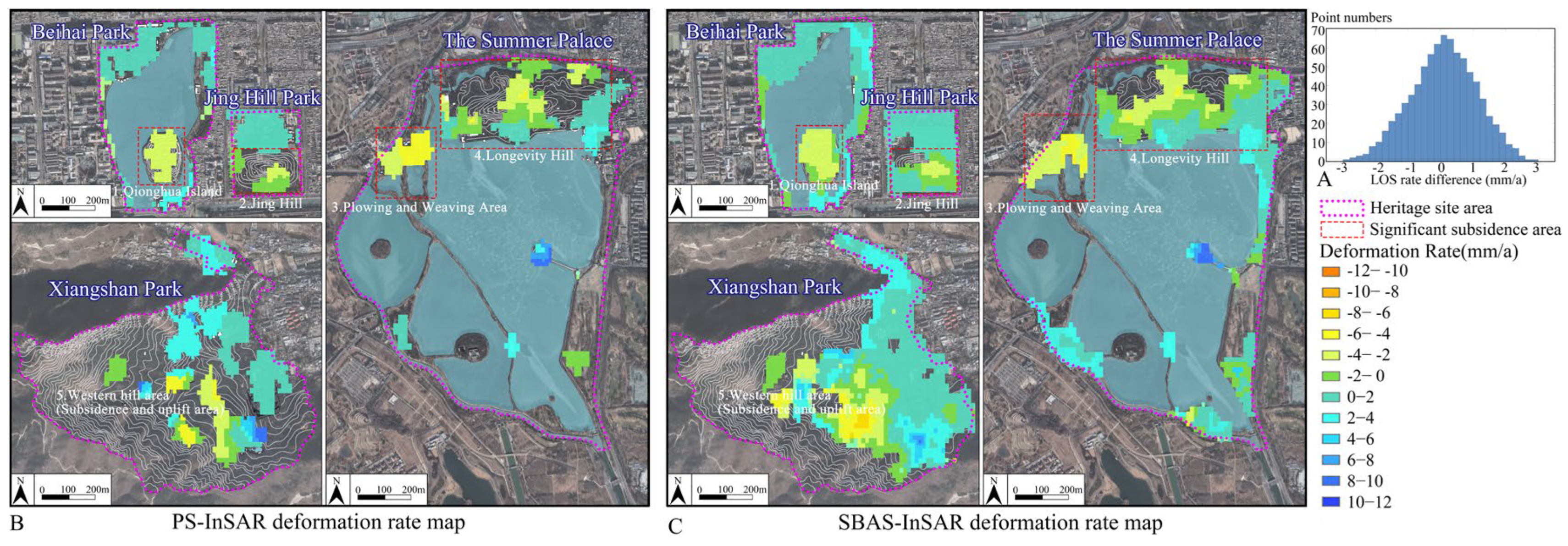
PS-InSAR obtains the subsidence results of the stable reflection points (persistent scatterers), while SBAS-InSAR procures the subsidence results of the continuous plane domain. Across the four gardens, the PS-InSAR technique identified 832 PS measurements, effectively capturing the buildings. In comparison, the SBAS-InSAR technique detected 1158 CT measurements, covering a broader deformation detection range than PS-InSAR. Coherent targets (CTs) and persistent scatterers (PSs) that exhibit spatial overlap were selected for quantitative analysis. A histogram was plotted based on the differences in annual velocity measurements obtained from the two methods (Figure 6A). The results follow a Gaussian normal distribution, with a mean difference of 0.21 mm/yr and a standard deviation of 0.98 mm/yr. The statistical measurement accuracy of the two MTInSAR methods is approximately 1.96 mm/yr (double the standard deviation), corresponding to a confidence interval of approximately 95%. This result is generally consistent with the accuracy range of previous studies [17,18,19]. Considering the uncertainties in InSAR-based land motion measurements, this study defines significant deformation pixels as regions where both PS-InSAR and SBAS-InSAR detect an absolute rate greater than 2 mm/yr. This threshold is the nearest higher integer within the 1.96 mm/yr uncertainty range, aiming to enhance the assessment standard as much as possible. Figure 6B shows the monitoring results of PS-InSAR for ancient buildings and their surroundings within the Beijing royal architectural heritage sites, and Figure 6C presents the results of SBAS-InSAR monitoring. The significant land subsidence areas identified by both methods are consistent, including Qionghua Island in Beihai Park, Jing Hill in Jing Hill Park, Longevity Hill and the Plowing and Weaving Area in the Summer Palace, and the western area of Xiangshan Park. The next step is to consider their location types to further analyze the spatial characteristics of the subsiding building heritage.
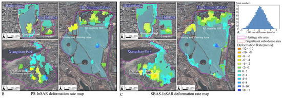
Figure 6.
Quantitative cross-comparison of PSs and SBAS-InSAR results. (A) Histogram of the differential annual velocity values between PSs and SBAS-InSAR. Subsidence monitoring results from 2019 to 2023 of (B) PS-InSAR and (C) SBAS−InSAR.
4.2. Spatial Characteristics of Land Subsidence in Building Heritage Sites
During the study period from 10 January 2019 to 27 December 2023, land deformation value in the heritage sites ranged from −49.79 mm to 45.63 mm, with positive values indicating uplift and negative values indicating subsidence.
Beihai Park has 239 ancient buildings covering an area of 25,000 m2. Over the five years from 2019 to 2023, 10 ancient building complexes within Beihai Park experienced subsidence, covering an area of approximately 8330 m2 (Figure 7A,B). The subsiding ancient buildings are primarily on Qionghua Island (Figure 6 and Figure 7A). According to the building location distribution map of Beihai Park (Figure 7B), the distribution of building locations is as follows: waterside and near-water buildings (Type A) account for 31%, buildings on gentle slopes (Type B) account for 36%, and buildings on hilly areas (Type C) constitute 33%. During the five-year monitoring period, subsiding building complexes were most prevalent among those in hilly areas, accounting for 79%. This was followed by waterfront and near-water buildings at 28% (Figure 7B).
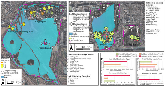
Figure 7.
The spatial distribution of building complexes experiencing land subsidence in Beihai Park, Jing Hill Park (A), and The Summer Palace (C). The proportion of building location types and percentage of subsidence area of different building types in Beihai Park (B) and The Summer Palace (D).
Adjacent to Beihai Park, Jing Hill Park has a smaller total area of gardens and ancient buildings and is a relatively small artificial hilly landscape garden. The park’s central feature is Jing Hill. During the monitoring period, three building complexes within Jing Hill Park experienced subsidence, all located on Jing Hill and covering an area of approximately 876 m2 (Figure 7A).
The Summer Palace, located in the western suburbs of Beijing, comprises Longevity Hill and Kunming Lake, with water bodies occupying approximately three-quarters of the total area. The Summer Palace is home to 881 ancient buildings, primarily built during the Qianlong period (1736–1795) and the Guangxu period (1875–1908) of the Qing Dynasty, with a total building area of nearly 80,502 m2. During the monitoring period, 13 ancient building complexes in the Summer Palace experienced subsidence, covering an area of approximately 18,628 m2, representing 13% of the total building area in the park (Figure 7C,D). Significant subsidence was observed in Longevity Hill and the Plowing and Weaving Area (Figure 6 and Figure 7C). According to the building location distribution map of the Summer Palace (Figure 7D), the distribution of building locations is as follows: waterside and near-water buildings (Type A) account for 36%, buildings on gentle slopes (Type B) make up 28%, and buildings in hilly areas (Type C) constitute 36%. From 2019 to 2023, the subsiding buildings are most concentrated in those in hilly areas, at 37%, covering an area of approximately 3895 m2, followed by 16% of waterside and near-water buildings and 6% of buildings on gentle slopes.
In the western part of the Summer Palace area and within the “Three Hills and Five Gardens” protection zone, Xiangshan Park is a hilly landscape garden with a steep western section and a relatively gentler eastern section (Figure 1B). During the monitoring period, the building complexes in the eastern part of the park exhibited minimal deformation, and noticeable subsidence and uplift areas were detected on the slopes supporting the ancient building complexes in the western part (Figure 6).
4.3. Analysis of Driving Factors of Land Subsidence
4.3.1. “Excavating Lakes and Piling Hills” Landscape and Environmental Influence
Based on the construction history of the heritage sites and borehole reports, combined with building construction methods, this part further investigates the causes of subsidence of Type C and Type A buildings concentrated in Qionghua Island of Beihai Park and Jing Hill of Jing Hill Park, as well as the Type A buildings in the Plowing and Weaving Area.
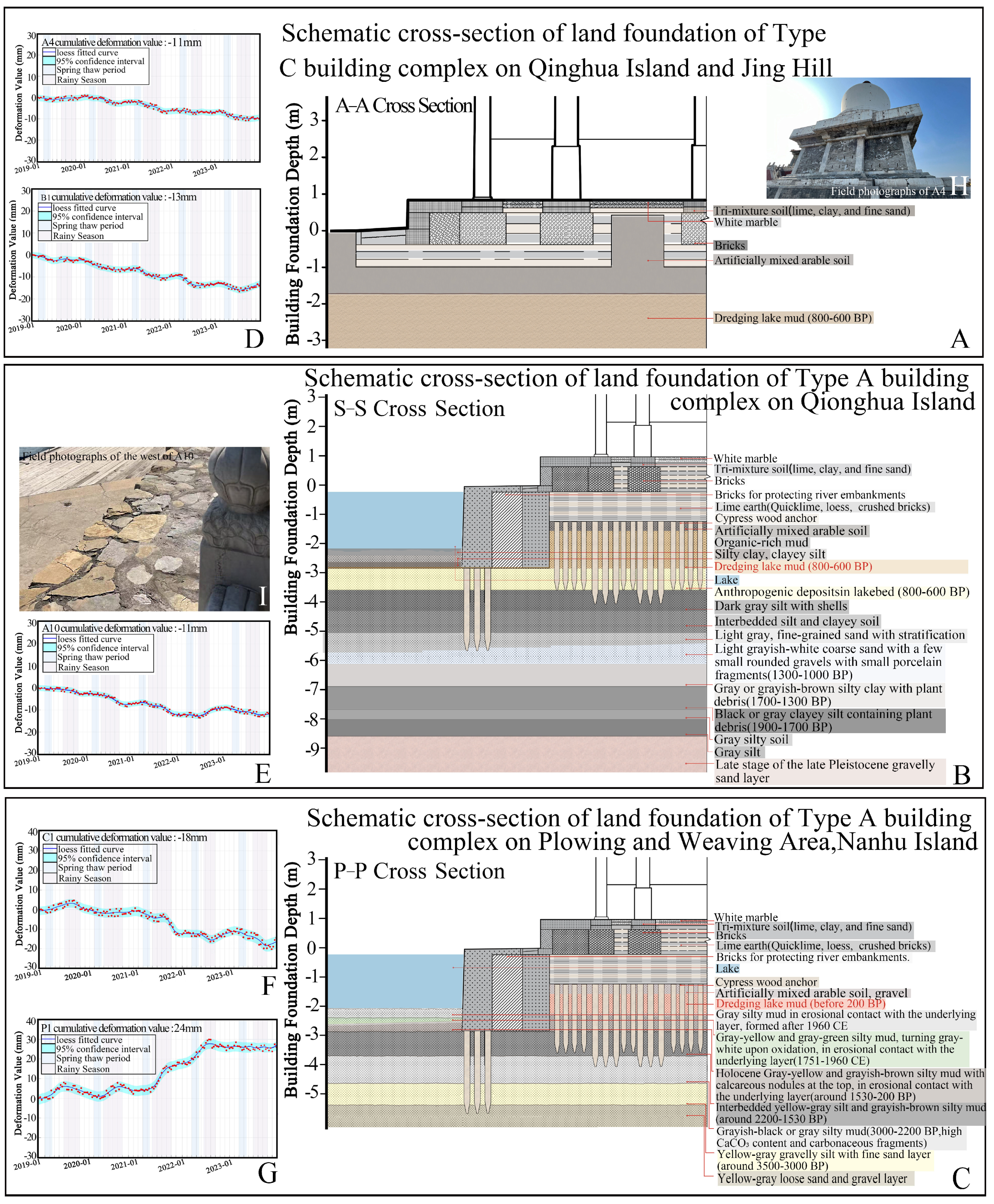
The area where the Beihai water body in Beihai Park and the Jing Hill in Jing Hill Park are located is part of the downstream section of the ancient Yongding River paleo-channel, formed approximately 45 ka BP to 25 ka BP. Historically, this area predates the formation of the lake at the Summer Palace. Around 1820 to 1295 BP, parts of the river began to shift southward, and after this river course change, Jing Hill gradually formed into a small earthen hill [1]. During the Jin and Yuan dynasties (approximately 800–600 BP), the emperor ordered the construction of the Xiyuan Imperial Palace, including the Beihai Area. Dredging and modifying the river channel’s contour shaped the Beihai water body’s outline. The dredged sediment from the lake excavation was used to pile up Qionghua Island with a relative height of approximately 32 m in the Beihai water body. The remaining dredged sediment was deposited on Jing Hill, shaping its current contour and height of 47 m. Subsequent emperors conducted several demolitions and reconstructions of buildings here and piled up Taihu stones to create artificial rock formations and caves on the mountain. Based on the Xiyuan drilling report by the Beijing Municipal Bureau of Cultural Heritage [40] and the construction methods and regulations of the Qing Ministry of Works [41], schematic cross-sections of the foundation were drawn for the typical Type C building Yongan Temple (Figure 8A) and the typical Type A building Yilan Hall (Figure 8B). These foundation cross-sections reveal that beneath the buildings’ adobe foundations, there is a thick layer of clay, silt, and dredged silt from the lake, rich in organic material, which is considered sediment from Holocene Lake or marsh environments. In the western part of Beihai Park, the Summer Palace has also been significantly influenced by human activities throughout its historical development. During the Jin and Yuan dynasties (approximately 800–600 BP), the eastern and southern areas of the lake at the Summer Palace were marshlands used for rice cultivation [40]. In 1749 (201 BP), during the Qing Dynasty, Emperor Qianlong constructed an imperial palace in this area. The Kunming Lake was formed by excavating the marshland and introducing water outside the garden. The excavated soil was used to pile up Nanhu Island (approximately one-sixth the size of Qionghua Island, featuring small mounds in the northern part with a generally gentle slope) and modify the Plowing and Weaving Area (which has a relatively flat terrain overall). Based on the construction methods and regulations of the Qing Ministry of Works [41] and core drilling studies of the sediment at the bottom of Kunming Lake at the Summer Palace [42], a P-P profile diagram was drawn to represent the typical foundation construction methods and composition of the underlying soil in the Plowing and Weaving Area and Nanhu Island (Figure 8C). It was found that beneath the building foundations and artificial soil, the ground primarily comprises a thick layer of Holocene Lake deposits.
Combined with the land deformation time series, the deformation trends in the time series obtained using SBAS-InSAR and PS-InSAR technologies are generally consistent. Since the deformation trend derived from SBAS-InSAR is relatively smooth and continuous in detail, a result that many other studies have corroborated [43,44,45], in this paper, we chose to present the deformation time series from SBAS-InSAR to avoid redundancy and found that the land deformation curves of Type C and Type A buildings, represented by A4 White Tower, A10 Yilan Hall, B1 Wanchun Pavilion, and C1 Yanshang Zhai, exhibited an accelerated subsidence trend during most thawing periods from March to April and concentrated rainfall periods from June to September (Figure 8D–F). According to on-site photographs, vertical cracks are visible on the walls and platform of the White Tower (A4) (Figure 8H). Cracks have also appeared on the railing and land surface at the waterside area west of Yilan Hall (A10) (Figure 8I). Significant cracks and noticeable peeling have also been observed on the wooden column bases of Yanshang Zhai (C1) and nearby buildings.
Many studies have shown that in low-energy, organic-rich depositional environments, such as lakes, wetlands, deltas, or alluvial plains, subsidence is likely to occur due to the presence of thick Late Pleistocene to Holocene sediments in the underlying soil [46,47,48]. The subsidence trend is influenced by the inherent characteristics of these sediments and further compression under static loads from buildings or rocks [49,50,51] and by the annual freeze–thaw phenomenon, concentrated rainfall, and fluctuations in groundwater levels [52,53,54,55,56]. Specifically, during the spring thaw from March to April, as temperatures gradually rise, lakes and soil begin to thaw, as well as during the concentrated rainfall period from June to September in summer; these climatic conditions may promote the decomposition of organic matter in the sediments [57], the swelling and shrinkage of montmorillonite [58,59,60], and the formation or dissolution of calcareous nodules [61]. Additionally, according to borehole reports [62], variations in the clay mineral montmorillonite content within sediments across different areas of the Summer Palace may influence land deformation. In some regions, the montmorillonite content reaches up to 40% in the stratigraphy [40]. As a result, areas such as Nanhu Island may also experience land uplift, as indicated by the Jianyuan Hall (P1) time series on Nanhu Island (Figure 8G). Additionally, the presence of non-swelling minerals (such as quartz and carbonates) dilutes the swelling and shrinkage of montmorillonite [58], which may introduce uncertainty to the land deformation trend.
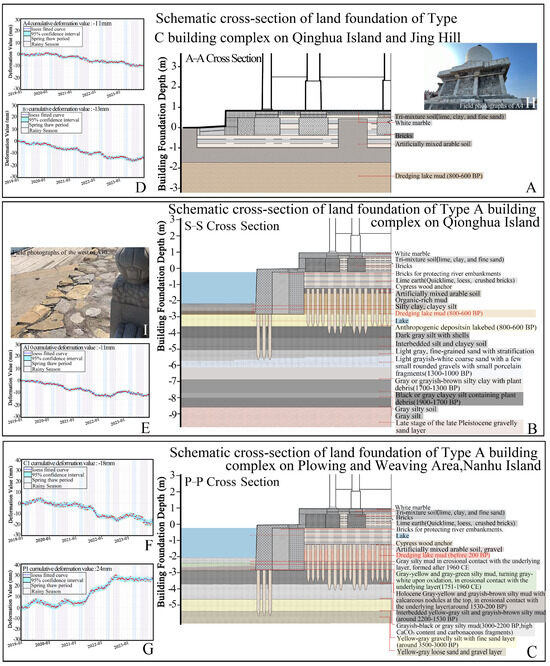
Figure 8.
Schematic cross-section of the land foundation of (A) Type C building complex at Qinghua Island and Jing Hill, (B) Type A building complex at Qionghua Island, (C) Type C building complex at Plowing and Weaving Area, Nanhu Island in The Summer Palace. Deformation over time of points for (D) Type C building complex at Qinghua Island and Jing Hill, (E) Type A building complex at Qionghua Island, Type C building complex at (F) Plowing and Weaving Area, and (G) Nanhu Island at The Summer Palace. The x-shaped data points indicate every single measurement, and the corresponding line represents their locally estimated scatterplot smoothing (LOESS) regression. The 95% line represents the confidence interval [63,64]. Field photographs of surface subsidence of (H) Type C building complex at Qinghua Island and (I) Type A building complex at Qinghua Island.
4.3.2. Rock Landscape and Rock Weathering
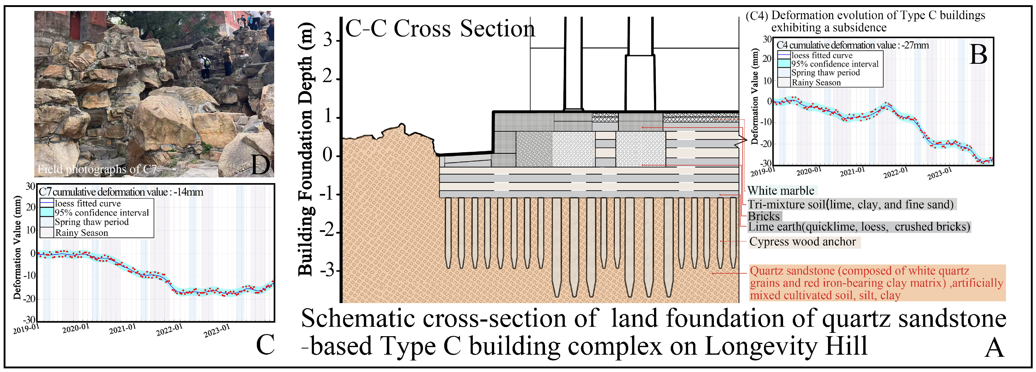
The causes of subsidence in hilly buildings (Type C) concentrated on Longevity Hill were studied based on the geological background of Longevity Hill and the construction methods of hilly buildings. Longevity Hill stands at a height of 58.59 m and has a surface area of approximately 36 × 104 m2 and a monocline structure. The formation and evolution of Longevity Hill can be traced back to at least 250 million years ago during the Permian period. Samples collected from Longevity Hill indicate that most of the hill, where the hill buildings are located, comprises rocks and brown soil. The hill rocks are mostly light red, with relatively large grains composed of white quartz grains and red iron-rich clays, forming a hard feldspar–quartz sandstone. The white quartz veins interspersed within the rock layers were formed by magmatic activity [65]. Around 1750, under Emperor Qianlong’s leadership, many hill-based buildings were constructed on Longevity Hill, and it was officially named Longevity Hill. According to the construction methods and regulations of the Qing Ministry of Works [41], during the Qianlong period, when constructing hill-based buildings, rectangular grooves were first excavated in the sandstone of Longevity Hill. Cypress wood piles were then driven into the bottom of the grooves. Following this, a layered construction method was applied within the grooves, alternating between lime, yellow earth, and broken bricks from bottom to top. Finally, stone slabs and floor tiles were laid on the topmost layer to serve as the foundation for the ancient buildings. For scenic purposes, parts of the quartz sandstone around the building’s platform were left exposed at the surface and sculpted into small rockeries, steps, and other features (Figure 9A).
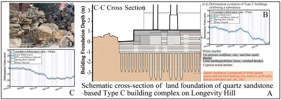
Figure 9.
Schematic cross-section of the land foundation of (A) Type C building complex at Longevity Hill. Deformation over time of points for (B,C) Type C building complex at Longevity Hill. The x-shaped data points indicate every single measurement, and the corresponding line represents their locally estimated scatterplot smoothing (LOESS) regression. The 95% line represents the confidence interval [63,64]. Field photographs of surface subsidence of (D) Type C building complex at Longevity Hill.
Recent research has found that Longevity Hill’s architectural heritage, including complexes such as Picture Travel (C4), Baoyun Ge (C6), and Four Great Continents (C7), exhibits varying degrees of weathering and rock detachment around its complexes’ exposed surfaces, accompanied by the risk of rock instability [66]. Weathering of rocks refers to the mechanical breakdown and chemical alteration processes that occur at or near the Earth’s surface due to temperature, water, and atmosphere. And weathering-induced detachment typically occurs after the gradual intensification of weathering processes, where the rocks’ surfaces lose their connection with the bedrock, causing some material to detach from the rocks [67]. Weathering is influenced by various external natural factors and is controlled by the rocks’ inherent properties and geological structure [68]. In a dry state, Longevity Hill rocks’ compressive strength ranges from 40 to 70 MPa, while their tensile strength ranges from 1.87 to 4.74 MPa, exhibiting brittle failure under low confining pressure [66]. After repeated freeze–thaw cycles, the compressive strength of the rock decreases, which may lead to land subsidence in hill-based buildings during the freeze–thaw alternation period in March and April. During the 2019–2023 monitoring period, the land deformation time series of the most hill-based building heritage complex, represented by the Four Great Continents (C7) and the Picture Travel complex (C4), showed relatively significant land subsidence trends in March and April of 2020, 2022, and 2023 (Figure 9B,C). The impact of freeze–thaw cycles on the weathering of sandstone architectural heritage has been widely documented in studies conducted in northern China [69,70]. The deformation time series also indicates that hilly buildings on Longevity Hill tend to experience accelerated subsidence during the rainy season, particularly in 2021, when rainfall was relatively high. It may be affected by the dry–wet cyclical climate, concentrated rainfall patterns, and rainwater scouring (Figure 2), which reduce the sandstone’s compressive and tensile strength, causing the loosening of weathered rock particles. In conditions of higher rainfall in 2021, the sandstone’s tensile strength significantly decreased when subjected to water immersion. The rock fragments, once cracked, were further affected by the water’s wedging action due to surface tension, causing severe cracking and even exfoliation [71]. This phenomenon has also been observed in experimental observations on sandstone cultural heritage at other Qing Dynasty imperial palaces and in other regions of northern China [72,73]. Field investigations revealed that the sandstone on the outdoor ground surfaces of Four Great Continents (C7) and Huafang Zhai (C4) had already developed long cracks along both vertical and horizontal directions (Figure 9D). Weathering may continue to expand these cracks, making the sandstone more vulnerable to damage and threatening the structural stability of the buildings. It is essential to promptly protect and restore the sandstone heritage elements in the outdoor areas of subsiding buildings on Longevity Hill.
4.3.3. Terrain-Based Landscape and Slope Instability
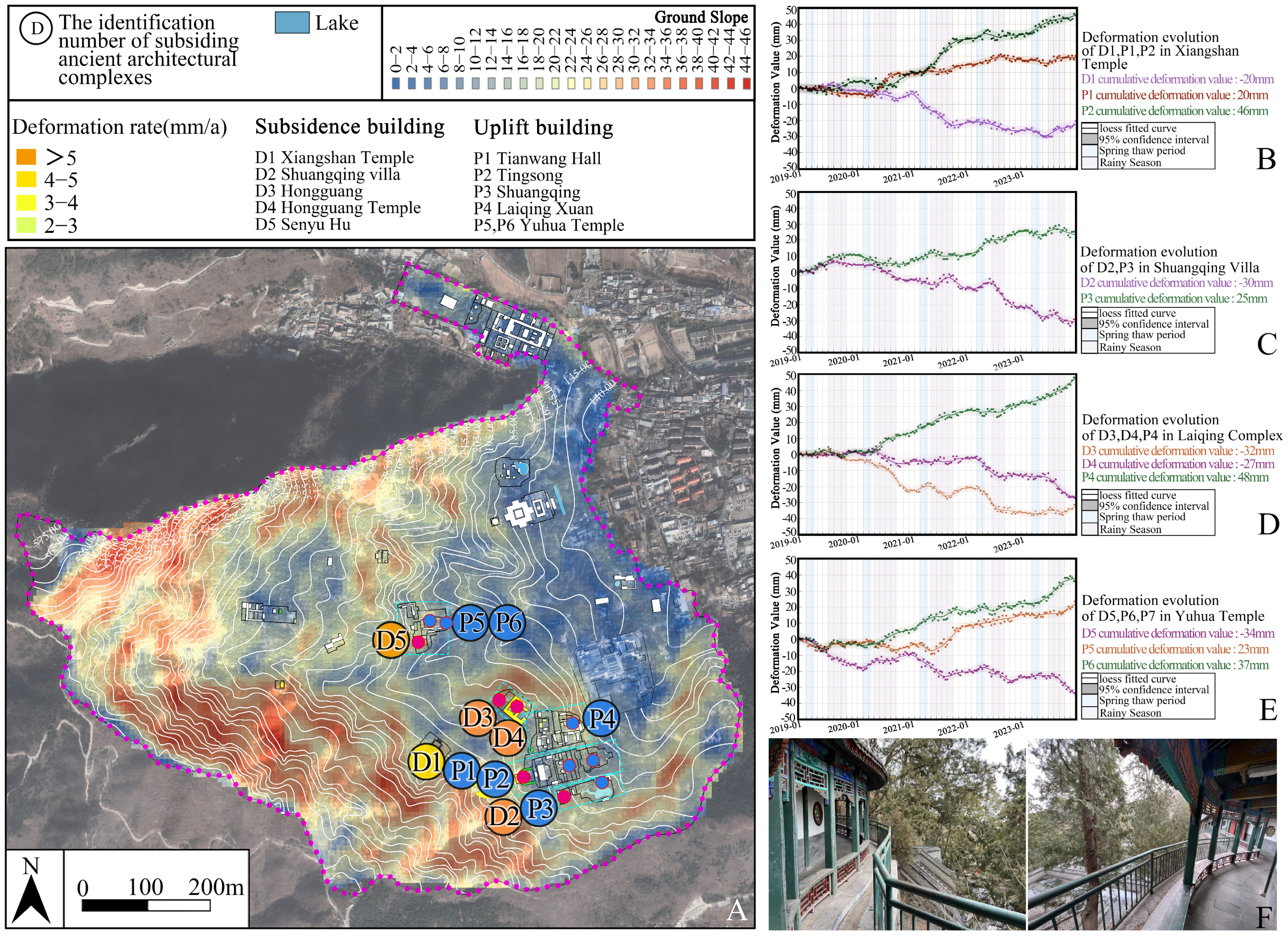
Xiangshan Park is located on the eastern foothills of the Western Hills in Beijing, with the terrain sloping from northeast to southwest (Figure 1). The average slope within Xiangshan Park is approximately 15° [74]. The eastern part of the park features relatively gentle terrain compared to the west, with an average slope of less than 10°, while the western part is steeper, with the steepest areas exceeding 45° (Figure 10A). The combination of steep terrain in the east and gentler areas in the west provides a topographical foundation for constructing architectural landscapes such as platforms. This makes Xiangshan Park a significant example of utilizing rugged terrain for landscape design in classical Chinese gardens.
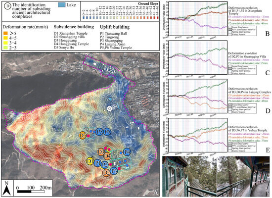
Figure 10.
(A) The spatial distribution of building complexes experiencing land subsidence in Xiangshan Park. Deformation over time of points for (B–E) Type C building complex in the western area of Xiangshan. The x-shaped data points indicate every single measurement, and the corresponding line represents their locally estimated scatterplot smoothing (LOESS) regression. The 95% line represents the confidence interval [63,64]. Field photographs of surface subsidence of (F) Type C building complex at Xiangshan Park.
During the monitoring period, building complexes located in the eastern part of the park, where the average slope is less than 10°, exhibited minimal subsidence. In contrast, significant subsidence areas were detected on the steep slopes supporting the ancient building complexes in the western mountainous region (Figure 6 and Figure 10A). Plotting the time series of different monitoring measurements within several building heritage complexes in areas with significant land deformation, it was found that during most rainy seasons, the deformation rate increases rapidly, and nearby monitoring measurements exhibit opposite deformation trends (Figure 10B–E). Sometimes, the impact of rainfall on the land deformation trend may change 1–2 months after the onset of rainfall, as observed in points such as D2 Shuangqing Villa, D3 Hongguang Temple, and D5 Senyu Hu (Figure 10C–E). This is related to the time required for groundwater infiltration and pressure transmission [75,76]. After the rainy season, some land may also experience rapid uplift, such as D3 Hongguang Temple in 2020 and D1 Xiangshan Temple in 2021 (Figure 10B,D). This is an adaptive process and has been observed in other studies [77]. Additionally, soil thawing from March to April and the rise in groundwater levels caused by rainfall can change ground deformation trends before and after the rainy season (Figure 10B–E). According to on-site investigations, multiple columns within the climbing hilled corridor in the subsiding area at D5 have developed vertical cracks, and some floor tiles show loosening (Figure 10F).
It is speculated that the land deformation characteristics in this area may be related to slope instability. According to data provided by the Xiangshan Park Management Office, the unstable slopes in Xiangshan have an average gradient of approximately 34–46°. The Xiangshan area has a complex structure, with extensive jointing and fissuring, strong rock weathering, and thick residual slope accumulation layers. The rocks are brittle, often forming unstable slopes along joints and fissures. Under extreme weather conditions, such as heavy rainfall, these areas are prone to natural disasters like landslides and debris flows [78]. The surface layer of land in the hilly region is approximately 15–30 m thick with yellow-brown clay, and the soil parent material is mostly weathered rock or colluvium. Previous studies have found that the yellow-brown clay in this area has low permeability, making it prone to soil erosion during concentrated summer rainfall, which can lead to ground subsidence [79]. During periods of concentrated rainfall and with the rise in moisture content, the bulk density of the slope increases, and the mechanical strength of the soil and rock mass decreases. The slopes in the Xiangshan area have low permeability, and during heavy rainfall, the rainwater cannot infiltrate quickly and is lost. In such conditions, land subsidence may occur [80,81,82]. In addition to rainfall, the soil freeze–thaw cycles caused by temperature changes may influence the development of land deformation [83,84].
5. Conclusions
- This study employs remote sensing technology to monitor the subsidence of landscape heritage sites and analyze influencing factors. By integrating PS-InSAR and SBAS-InSAR techniques, the land subsidence of ancient buildings in four royal gardens in Beijing from 2019 to 2023 was analyzed. The significant subsidence areas identified by both methods are consistent;
- By further analyzing the subsiding areas to the location types of buildings within the heritage sites, it was found that hilly buildings (Type C), waterside buildings (Type A1), and near-water buildings (Type A2) are relatively more prone to subsidence;
- The subsidence of Type C and Type A buildings on islands in Beihai Park, the hills in Jing Hill Park, and the northeastern scenic area in the Summer Palace may be attributed to “excavating lakes and piling hills” construction methods, which led to the presence of thick Holocene sediments in the subsoil of these heritage sites. The land subsidence trends in these areas are influenced by their intrinsic characteristics and environmental factors, such as temperature and rainfall;
- Since the Summer Palace utilizes the rock of Longevity Hill as the foundation for landscape design, Xiangshan Park relies on its steep terrain for scenic construction. The subsidence of hilly building complexes on Longevity Hill may be related to the exposure and weathering-induced detachment of local rock formations. The subsidence of hilly building complexes in the western region of Xiangshan Park may be associated with slope instability;
- While Beijing’s royal gardens represent unique cultural heritage sites created through the modification and utilization of natural landscapes, these activities may lead to land deformation, affecting building complexes under environmental influences such as concentrated rainfall and freeze–thaw phenomenon. Current protective measures for ancient buildings are relatively traditional and lagging. Adopting long-term monitoring using InSAR technology to enhance management is recommended, particularly strengthening observations during the critical periods of March–April thawing and June–September concentrated rainfall;
- In the future, it is hoped that higher-resolution InSAR data can be utilized to enhance the accuracy of long-term deformation monitoring. Additionally, incorporating GNSS data from modern garden sites could further validate InSAR results. It is also recommended to expand the research scope by including contemporary landscape gardens with GNSS measurements to better quantify the uncertainties associated with the detected deformation trends.
Supplementary Materials
The following supporting information can be downloaded at: https://www.mdpi.com/article/10.3390/heritage8040113/s1, Table S1: Acquisition SAR dates (yyyymmdd).
Author Contributions
Conceptualization, J.C.; methodology, J.C.; software, J.C.; validation, J.C., S.C. and F.S.; formal analysis, J.C.; investigation, J.C. and S.C.; resources, J.C.; data curation, J.Z. and J.C.; writing—original draft preparation, J.C.; writing—review and editing, J.C.; visualization, J.C., F.S.; supervision, J.Z. and S.C. All authors have read and agreed to the published version of the manuscript.
Funding
This research was funded by the All Directional Innovation Creator Ph.D. Project of Japan (grant number 240PT18040), Japan Science and Technology Agency.
Data Availability Statement
Data will be made available upon request.
Conflicts of Interest
The authors declare no conflicts of interest. The authors declare that they have no known competing financial interests or personal relationships that could have appeared to influence the work reported in this paper.
References
- Zhou, W. The History of Chinese Classical Gardens; Tsinghua University Press: Beijing, China, 2008. (In Chinese) [Google Scholar]
- Zu, Z. Ying Cheng Jushen Jianggong; Beijing Press: Beijing, China, 2021. (In Chinese) [Google Scholar]
- Pugh, R.S. Briefing: Some observations on the influence of recent climate change on the subsidence of shallow foundations. J. Geotech. Geoenviron. Eng. 2002, 155, 23–25. [Google Scholar] [CrossRef]
- Costa, A.L.; Kok, S.; Korff, M. Systematic assessment of damage to buildings due to groundwater lowering-induced subsidence: Methodology for large scale application in the Netherlands. Proc. IAHS 2020, 382, 577–582. [Google Scholar] [CrossRef]
- Ao, Z.; Hu, X.; Tao, S.; Hu, X.; Wang, G.; Li, M.; Wang, F.; Hu, L.; Liang, X.; Xiao, J.; et al. A national-scale assessment of land subsidence in China’s major cities. Science 2024, 384, 301–306. [Google Scholar] [CrossRef] [PubMed]
- Pei, F.M.; Wei, X.W.; Bowen, Z. Remotely sensing large- and small-scale ground subsidence: A case study of the Guangdong–Hong Kong–Macao Greater Bay Area of China. Remote Sens. Environ. 2019, 232, 111282. [Google Scholar] [CrossRef]
- Chen, B.; Gong, H.; Li, X.; Lei, K.; Ke, Y.; Duan, G.; Zhou, C. Spatial correlation between land subsidence and urbanization in Beijing, China. Nat. Hazards 2015, 75, 2637–2652. [Google Scholar] [CrossRef]
- Si, Y.; Chen, B.; Gong, H.; Gao, M. Temporal and spatial evolution of land subsidence induced by groundwater exploitation and construction in the eastern Chaoyang District, Beijing, China. J. Indian Soc. Remote Sens. 2018, 46, 1657–1665. [Google Scholar] [CrossRef]
- Zhou, C.; Gong, H.; Zhang, Y.; Warner, T.; Wang, C. Spatiotemporal evolution of land subsidence in the Beijing plain 2003–2015 using persistent scatterer interferometry (PSI) with multi-source SAR data. Remote Sens. 2018, 10, 552. [Google Scholar] [CrossRef]
- Du, Z.; Ge, L.; Ng, A.H.M.; Xiaojing, L.; Li, L. Mapping land subsidence over the eastern Beijing city using satellite radar interferometry. Int. J. Digit. Earth 2018, 11, 504–519. [Google Scholar] [CrossRef]
- Chen, B.; Gong, H.; Chen, Y.; Li, X.; Zhou, C.; Lei, K.; Zhu, L.; Duan, L.; Zhao, X. Land subsidence and its relation with groundwater aquifers in Beijing Plain of China. Sci. Total Environ. 2020, 735, 139111. [Google Scholar] [CrossRef]
- Zhang, J.; Liu, H.; Sun, X.; Liu, S. Processing of building subsidence monitoring data based on fusion Kalman filtering algorithm. Alex. Eng. J. 2021, 60, 3353–3360. [Google Scholar] [CrossRef]
- Sui, L.; Zhu, H.; Fang, C.; Zhai, S. Ground fissure monitoring based on 3D terrestrial laser scanning techniques. In Proceedings of the 2017 7th International Conference on Manufacturing Science and Engineering (ICMSE 2017); Atlantis Press: Dordrecht, The Netherlands, 2017; pp. 67–71. [Google Scholar] [CrossRef]
- Pesci, A.; Casula, G.; Boschi, E. Laser scanning the Garisenda and Asinelli towers in Bologna (Italy): Detailed deformation patterns of two ancient leaning buildings. J. Cult. Herit. 2011, 12, 117–127. [Google Scholar] [CrossRef]
- Bonali, E.; Pesci, A.; Casula, G.; Boschi, E. Deformation of ancient buildings inferred by terrestrial laser scanning methodology: The Cantalovo church case study (Northern Italy). Archaeometry 2014, 56, 703–716. [Google Scholar] [CrossRef]
- Dzurisin, D.; Lu, Z. Interferometric synthetic-aperture radar (InSAR). In Volcanol Deformation: Geodetic Monitoring Techniques; Dzurisin, D., Ed.; Springer: Berlin/Heidelberg, Germany, 2007; pp. 153–194. [Google Scholar] [CrossRef]
- Yang, K.; Yan, L.; Huang, G.; Chen, C.; Wu, Z. Monitoring building deformation with InSAR: Experiments and validation. Sensors 2016, 16, 2182. [Google Scholar] [CrossRef]
- Yan, H.; Dai, W.; Xu, W.; Shi, Q.; Sun, K.; Lu, Z.; Wang, R. A method for correcting InSAR interferogram errors using GNSS data and the K-means algorithm. Earth Planets Space 2024, 76, 51. [Google Scholar] [CrossRef]
- Luo, K.; Zhang, Z.; He, Y. Improved registration algorithm for SAR image based on stable point of PS-InSAR. In Proceedings of the International Conference on Electronic Information Engineering and Computer Communication (EIECC 2021), Nanchang, China, 17–19 December 2021; SPIE: Bellingham, WA, USA, 2022; Volume 12172. [Google Scholar]
- Lu, Z. Interferometric synthetic aperture radar: Building tomorrow’s tools today. Alsk. Satell. Facil. News Notes 2006, 15, 12–14. [Google Scholar]
- Ng, A.H.M.; Liu, Z.; Du, Z.; Huang, H.; Wang, H.; Ge, L. A novel framework for combining polarimetric Sentinel-1 InSAR time series in subsidence monitoring—A case study of Sydney. Remote Sens. Environ. 2023, 295, 113694. [Google Scholar] [CrossRef]
- Tapete, D.; Cigna, F. InSAR data for geohazard assessment in UNESCO World Heritage sites: State-of-the-art and perspectives in the Copernicus era. Int. J. Appl. Earth Obs. Geoinf. 2017, 63, 24–32. [Google Scholar] [CrossRef]
- Chen, F.; Zhou, W.; Tang, Y.; Li, R.; Lin, H.; Balz, T.; Luo, J.; Shi, P.; Zhu, M.; Fang, C. Remote sensing-based deformation monitoring of pagodas at the Bagan cultural heritage site, Myanmar. Int. J. Digit. Earth 2022, 15, 770–788. [Google Scholar] [CrossRef]
- Sousa, J.J.; Lin, J.; Wang, Q.; Liu, G.; Fan, J.; Bai, S.; Zhao, H.; Pan, H.; Wei, W.; Rittlinger, V.; et al. Using machine learning and satellite data from multiple sources to analyze mining, water management, and preservation of cultural heritage. Geo-Spat. Inf. Sci. 2024, 27, 552–571. [Google Scholar] [CrossRef]
- Ge, Y.; Liu, Y.; Cong, Y.; Hu, Z.; Feng, J. Surface soil fertility quality evaluation of green land in the Summer Palace. J. Nanjing For. Univ. 2023, 47, 182. [Google Scholar]
- Chen, R.; Lu, R. Dry Tropical Nights and Wet Extreme Heat in Beijing: Atypical Configurations Between High Temperature and Humidity. Mon. Weather Rev. 2014, 142, 1792–1802. [Google Scholar] [CrossRef]
- Wang, X.; Chen, R. Freezing and thawing characteristics of seasonally frozen ground across China. Geoderma 2024, 448, 116966. [Google Scholar] [CrossRef]
- Zhang, B. Architectural Family Yangshi Lei; Beijing Press: Beijing, China, 2018. [Google Scholar]
- Lou, Q. Twenty Lectures on Ancient Chinese Architecture; Sanlian Publishing Press: Hong Kong, China, 2004. [Google Scholar]
- Li, Y.; Yang, K.; Hou, Z.; Zhang, J.; Hou, Z.; Wang, S.; Ding, X. Research on Time Series InSAR Monitoring Method for Multiple Types of Surface Deformation in Mining Area. Nat. Hazards 2022, 114, 2479–2508. [Google Scholar]
- Osmanoğlu, B.; Sunar, F.; Wdowinski, S.; Cabral-Cano, E. Time series analysis of InSAR data: Methods and trends. ISPRS J. Photogramm. 2016, 115, 90–102. [Google Scholar] [CrossRef]
- Ferretti, A.; Monti-Guarnieri, A.; Prati, C.; Rocca, F.; Massonnet, D. InSAR Principles: Guidelines for SAR Interferometry Processing and Interpretation; European Space Agency: Noordwijk, The Netherlands, 2007; Volume 19, ISBN 92-9092-233-8. Available online: https://ui.adsabs.harvard.edu/abs/2007ESATM..19.....F/abstract (accessed on 1 February 2025).
- Xia, Y. Synthetic aperture radar interferometry. In Sciences of Geodesy-I: Advances and Future Directions; Xu, G., Ed.; Springer: Berlin/Heidelberg, Germany, 2010; pp. 415–474. [Google Scholar] [CrossRef]
- Ferretti, A.; Prati, C.; Rocca, F. Permanent scatterers in SAR interferometry. IEEE Trans. Geosci. Remote Sens. 2001, 39, 8–20. [Google Scholar] [CrossRef]
- Mao, W.; Zhang, J.; Li, C.; Gao, J.Z.; Xie, W.; Xu, Y. Quality inspection of surface deformation monitoring results based on PS-Insar Technology. ISPRS Ann. Photogramm. Remote Sens. Spat. Inf. Sci. 2022, 3, 597–602. [Google Scholar] [CrossRef]
- Ferretti, A.; Prati, C.; Rocca, F. Nonlinear subsidence rate estimation using permanent scatters in differential SAR interferometry. IEEE Trans. Geosci. Remote Sens. 2000, 38, 2202–2212. [Google Scholar] [CrossRef]
- Berardino, P.; Fornaro, G.; Lanari, R. A new algorithm for surface deformation monitoring based on small baseline differential SAR interferograms. IEEE Trans. Geosci. Remote Sens. 2002, 40, 2375–2383.10. [Google Scholar]
- Li, S.; Xu, W.; Li, Z. Review of the SBAS InSAR time-series algorithms, applications, and challenges. Geod. Geodyn. 2022, 13, 114–126. [Google Scholar] [CrossRef]
- Tao, Q.; Wang, F.; Guo, Z.; Hu, L.; Yang, C.; Liu, T. Accuracy verification and evaluation of small baseline subset (SBAS) interferometric synthetic aperture radar (InSAR) for monitoring mining subsidence. Eur. J. Remote Sens. 2021, 54, 642–663. [Google Scholar] [CrossRef]
- Ma, Y.; Yue, S.; Xu, H.; Zhang, P. Evidence in Stratum for Shichahai Becoming Lake from Han-Dynasty to Yuan-Dynasty: A Case of the Southern Section at the Western Side of Building Site in Xiaoshibei Hutong. Acta Sci. Nat. Univ. Pekin. 2015, 51, 451. [Google Scholar]
- Liang, S.C. The Construction Methods and Regulations of the Qing Ministry of Works; Qing Dynasty Ministry of Works; Commercial Press: Beijing, China, 1982. [Google Scholar]
- Huang, C.; Pu, Q.; Ji, C.; Pang, Q.; Liu, Y.; Kong, Z.; Min, L.; Shen, G.; Liu, C.; Zhai, X. Research on the Sediments of Kunming Lake in the Summer Palace over the Past 3500 Years; Ocean Press: Beijing, China, 1996. [Google Scholar]
- Yao, J.; Yao, X.; Liu, X. Landslide Detection and Mapping Based on SBAS-InSAR and PS-InSAR: A Case Study in Gongjue County, Tibet, China. Remote Sens. 2022, 14, 4728. [Google Scholar] [CrossRef]
- Zhang, Z.; Hu, C.; Wu, Z.; Zhang, Z.; Yang, S.; Yang, W. Monitoring and analysis of ground subsidence in Shanghai based on PS-InSAR and SBAS-InSAR technologies. Sci. Rep. 2023, 13, 8031. [Google Scholar] [CrossRef]
- Li, Y.; Zuo, X.; Yang, F.; Bu, J.; Wu, W.; Liu, X. Effectiveness Evaluation of DS-InSAR Method Fused PS Points in Surface Deformation Monitoring: A Case Study of Hongta District, Yuxi City, China. Geomat. Nat. Hazards Risk 2023, 14, 2176011. [Google Scholar] [CrossRef]
- Nappo, N.; Peduto, D.; Polcari, M.; Livio, F.; Ferrario, M.F.; Comerci, V.; Stramondo, S.; Michetti, A.M. Subsidence in Como historic centre (northern Italy): Assessment of building vulnerability combining hydrogeological and stratigraphic features, Cosmo-SkyMed InSAR and damage data. Int. J. Disaster Risk Reduc. 2021, 56, 102115. [Google Scholar] [CrossRef]
- Ferrario, M.F.; Bonadeo, L.; Brunamonte, F.; Livio, F.; Martinelli, E.; Michetti, A.M.; Censi Neri, P.; Chiessi, V.; Comerci, V.; Höbig, N. Late Quaternary environmental evolution of the Como urban area (Northern Italy): A multidisciplinary tool for risk management and urban planning. Eng. Geol. 2015, 193, 384–401. [Google Scholar]
- Meckel, T.A.; ten Brink, U.S.; Williams, S.J. Current Subsidence Rates Due to Compaction of Holocene Sediments in Southern Louisiana. Geophys. Res. Lett. 2006, 33. [Google Scholar] [CrossRef]
- Liu, Y.; Liu, J.; Xia, X.; Bi, H.; Huang, H.; Ding, R.; Zhao, L. Land Subsidence of the Yellow River Delta in China Driven by River Sediment Compaction. Sci. Total Environ. 2021, 750, 142165. [Google Scholar] [CrossRef]
- Amorosi, A.; Pacifico, A.; Rossi, V.; Ruberti, D. Late Quaternary Incision and Deposition in an Active Volcanic Setting: The Volturno Valley Fill, Southern Italy. Sediment. Geol. 2012, 282, 307–320. [Google Scholar] [CrossRef]
- Gruber, S. Ground Subsidence and Heave Over Permafrost: Hourly Time Series Reveal Interannual, Seasonal, and Shorter-Term Movement Caused by Freezing, Thawing, and Water Movement. Cryosphere 2020, 14, 1437–1447. [Google Scholar] [CrossRef]
- Cao, Q.; Zhang, Y.; Yang, L.; Chen, J.; Hou, C. Unveiling the Driving Factors of Urban Land Subsidence in Beijing, China. Sci. Total Environ. 2024, 916, 170134. [Google Scholar] [CrossRef]
- Dai, K.; Shi, X.; Gou, J.; Hu, L.; Chen, M.; Zhao, L.; Dong, X.; Li, Z. Diagnosing Subsidence Geohazard at Beijing Capital International Airport, from High-Resolution SAR Interferometry. Sustainability 2020, 12, 2269. [Google Scholar] [CrossRef]
- Raspini, F.; Loupasakis, C.; Rozos, D.; Adam, N.; Moretti, S. Ground subsidence phenomena in the Delta municipality region (Northern Greece): Geotechnical modeling and validation with Persistent Scatterer Interferometry. Int. J. Appl. Earth Obs. Geoinf. 2014, 28, 78–89. [Google Scholar] [CrossRef]
- Guo, H.; Zhang, Z.; Cheng, G.; Li, W.; Li, T.; Jiao, J.J. Groundwater-derived land subsidence in the North China Plain. Environ. Earth Sci. 2015, 74, 1415–1427. [Google Scholar] [CrossRef]
- Kasai, M.; Ikeda, M.; Asahina, T.; Fujisawa, K. LiDAR-Derived DEM Evaluation of Deep-Seated Landslides in a Steep and Rocky Region of Japan. Geomorphology 2009, 113, 57–69. [Google Scholar] [CrossRef]
- Liu, Y.; Wang, X.; Wen, Q.; Zhu, N. Identifying Sources and Variations of Organic Matter in an Urban River in Beijing, China Using Stable Isotope Analysis. Ecol. Indic. 2019, 102, 783–790. [Google Scholar] [CrossRef]
- Fakhri, F.; Kalliola, R. Monitoring ground deformation in the settlement of Larissa in Central Greece by implementing SAR interferometry. Nat. Hazards 2015, 78, 1429–1445. [Google Scholar] [CrossRef]
- Burnol, A.; Foumelis, M.; Gourdier, S.; Deparis, J.; Raucoules, D. Monitoring of Expansive Clays Over Drought-Rewetting Cycles Using Satellite Remote Sensing. Atmosphere 2021, 12, 1262. [Google Scholar] [CrossRef]
- Hazirbaba, K. Effects of freeze-thaw on settlement of fine grained soil subjected to cyclic loading. Cold Reg. Sci. Technol. 2019, 160, 222–229. [Google Scholar] [CrossRef]
- Wang, Z.; Cao, C.; Yu, Q.; Wang, Q.; Niu, C.; Shen, J.; Zhu, K.; Liu, J.; Han, M.; Fu, H.; et al. Multi-Scale Failure Mechanisms of Hydraulic Engineering Exposed to Seasonally Frozen Salinization Environment: Integrating SBAS-InSAR and Mechanical Experiments. Sci. Total Environ. 2024, 912, 169210. [Google Scholar] [CrossRef]
- Matano, F.; Sacchi, M.; Vigliotti, M.; Ruberti, D. Subsidence Trends of Volturno River Coastal Plain (Northern Campania, Southern Italy) Inferred by SAR Interferometry Data. Geosciences 2018, 8, 8. [Google Scholar] [CrossRef]
- Cleveland, W.S. Robust locally weighted regression and smoothing scatterplots. J. Am. Stat. Assoc. 1979, 74, 829–836. [Google Scholar] [CrossRef]
- Zambanini, C.; Reinprecht, V.; Kieffer, D.S. InSARTrac Field Tests—Combining Computer Vision and Terrestrial InSAR for 3D Displacement Monitoring. Remote Sens. 2023, 15, 2031. [Google Scholar] [CrossRef]
- Bai, J. The Study of Planting Design of Longevity Hill of the Summer Palace; Chinese Academy of Sciences, The Forestry Summer Palace Management Office: Beijing, China, 2014. [Google Scholar]
- Yang, J.; Qin, J.; Ba, Z.; Zhang, L.; Liu, Y. Physical-mechanical test and mineral analysis of rock forming longevity hill of Summer Palace, Beijing. J. Eng. Geol. 2016, 24, 292–298. [Google Scholar]
- Kun, H.; Xiong, X. (Eds.) Civil Engineering Geology; Beijing Institute of Technology Press: Beijing, China, 2017. [Google Scholar]
- Hong, S. Engineering Geology; Shanghai Jiao Tong University Press: Shanghai, China, 2023. [Google Scholar]
- Chen, W.; Liao, R.; Wang, N.; Zhang, J. Effects of experimental frost–thaw cycles on sandstones with different weathering degrees: A case from the Bingling Temple Grottoes, China. Bull. Eng. Geol. Environ. 2019, 78, 5311–5326. [Google Scholar] [CrossRef]
- Li, L.; Shao, M.; Wang, S.; Li, Z. Preservation of earthen heritage sites on the Silk Road, northwest China from the impact of the environment. Environ. Earth Sci. 2011, 64, 1625–1639. [Google Scholar] [CrossRef]
- Shao, M.; Zhang, Z.; Li, L. Properties and Deterioration Mechanism of Sandstone Blocks in Chengde Royal Buildings Between 1703 and 1792. J. Eng. Geol. 2015, 23, 533–538. [Google Scholar] [CrossRef]
- Sun, B.; Li, X.; Cui, K.; Hong, J.; Chen, R.; Jia, C.; Peng, N. Experimental Study on the Effects of Hydrochemistry and Periodic Changes in Temperature and Humidity on Sandstone Weathering in the Longshan Grottoes. Heritage Sci. 2023, 11, 173. [Google Scholar] [CrossRef]
- Guo, F.; Jiang, G. Investigation into rock moisture and salinity regimes: Implications of sandstone weathering in Yungang Grottoes, China. Carbonates Evaporites 2015, 30, 1–11. [Google Scholar] [CrossRef]
- Gao, B.; Zhang, J.; Liao, X.; Zhang, H.; Ye, C. Stability analysis and prevention measures of rock slope in mountain scenic area. J. Eng. Geol. 2022, 30, 1316–1324. [Google Scholar] [CrossRef]
- Xia, C.-A.; Zhang, J.-Q.; Wang, H.; Jian, W.-B. Global Sensitivity Analysis of Slope Stability Considering Effective Rainfall with Analytical Solutions. Water 2025, 17, 141. [Google Scholar] [CrossRef]
- Tian, W.; Peiffer, H.; Malengier, B.; Liu, G.; Cheng, Q. Numerical Investigation of Rainfall Infiltration-Induced Slope Stability Considering Water-Air Two-Phase Flow; IntechOpen: London, UK, 2024. [Google Scholar] [CrossRef]
- Makabayi, B.; Musinguzi, M.; Otukei, J.R. Estimation of Ground Vertical Displacement in Landslide Prone Areas Using PS-InSAR: A Case Study of Bududa, Uganda. Int. J. Geosci. 2021, 12, 108701. [Google Scholar] [CrossRef]
- Zhang, Z.; Yang, X.; Ye, F.; Zhou, H.; Zhang, T. Microscopic Characteristics of Petrography and Discussion on Weathering Mechanism of Fangshan Marble in Beijing. J. Eng. Geol. 2015, 23, 279–286. [Google Scholar] [CrossRef]
- Wang, X.; Meng, Q.; Liu, X.; Allam, M.; Zhang, L.; Hu, X.; Bi, Y.; Jancsó, T. Evaluation of Fairness of Urban Park Green Space Based on an Improved Supply Model of Green Space: A Case Study of Beijing Central City. Remote Sens. 2022, 15, 244. [Google Scholar] [CrossRef]
- Singh, H.; Huat, B.B.K.; Jamaludin, S. Slope Assessment Systems: A Review and Evaluation of Current Techniques Used for Cut Slopes in the Mountainous Terrain of West Malaysia. Electron. J. Geotech. Eng. 2008, 13, 1–24. [Google Scholar]
- Migoń, P.; Jancewicz, K.; Różycka, M.; Duszyński, F.; Kasprzak, M. Large-Scale Slope Remodelling by Landslides–Geomorphic Diversity and Geological Controls, Kamienne Mts., Central Europe. Geomorphology 2017, 289, 134–151. [Google Scholar] [CrossRef]
- Ren, P. Analysis of Geothermal Conditions in the Xiangshan Area of Beijing and the Study of the Relationship Between Drilling Speed and Stratigraphy. Master’s Thesis, China University of Geosciences, Beijing, China, 2006. [Google Scholar]
- Harris, C.; Smith, J.S.; Davies, M.C.R.; Rea, B. An Investigation of Periglacial Slope Stability in Relation to Soil Properties Based on Physical Modelling in the Geotechnical Centrifuge. Geomorphology 2008, 93, 437–459. [Google Scholar] [CrossRef]
- Liu, H.; Yang, Y.; Zhang, K.; Sun, C. Soil Erosion as Affected by Freeze-Thaw Regime and Initial Soil Moisture Content. Soil Sci. Soc. Am. J. 2017, 81, 859–869. [Google Scholar] [CrossRef]


Disclaimer/Publisher’s Note: The statements, opinions and data contained in all publications are solely those of the individual author(s) and contributor(s) and not of MDPI and/or the editor(s). MDPI and/or the editor(s) disclaim responsibility for any injury to people or property resulting from any ideas, methods, instructions or products referred to in the content. |
© 2025 by the authors. Licensee MDPI, Basel, Switzerland. This article is an open access article distributed under the terms and conditions of the Creative Commons Attribution (CC BY) license (https://creativecommons.org/licenses/by/4.0/).