
Spatial Characteristics of Land Subsidence in Architectural Heritage Sites of Beijing’s Royal Gardens Based on Remote Sensing


Abstract
1. Introduction
2. Study Area and Collected Data
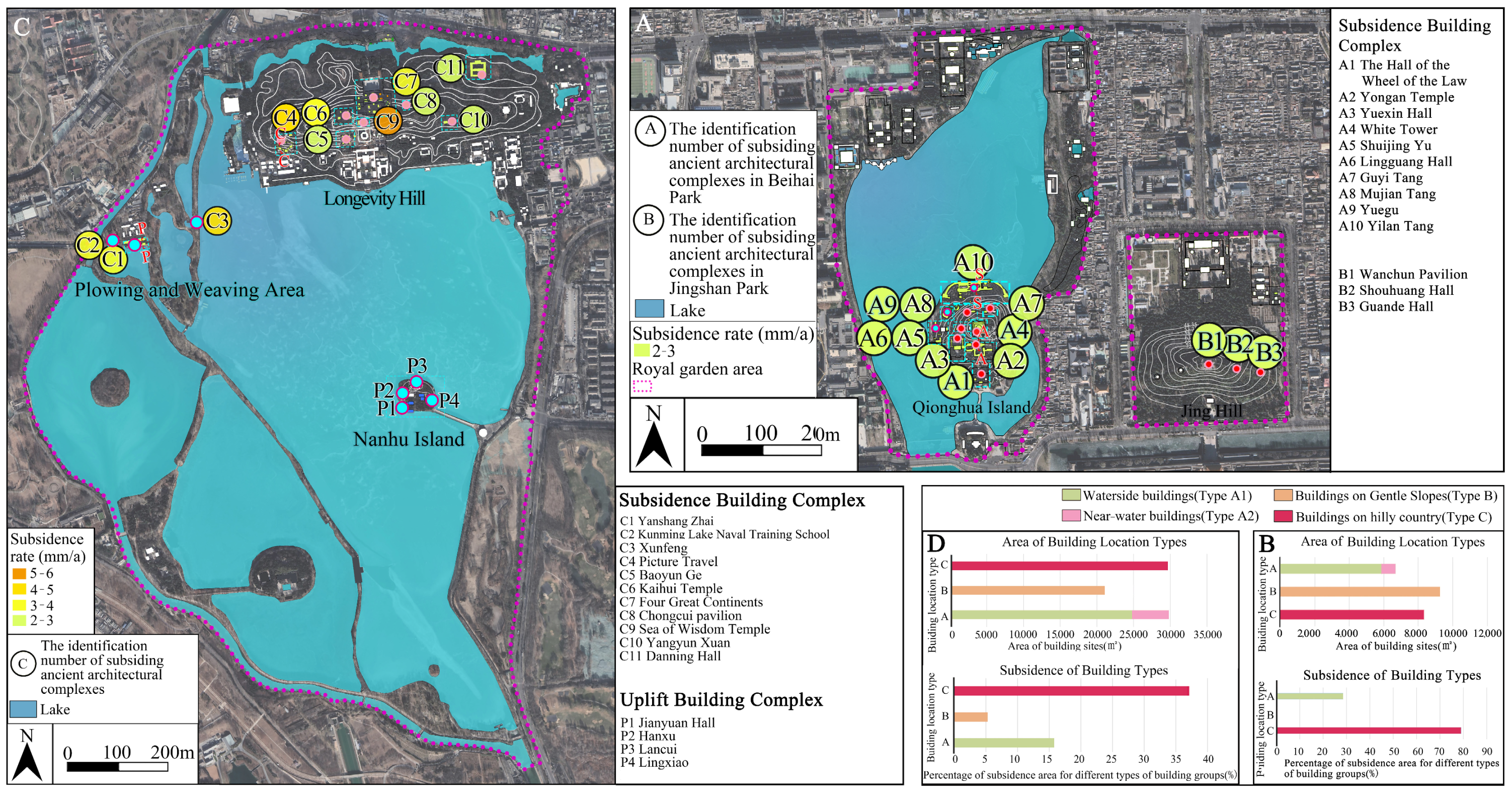
2.1. Target Area of Research
- Waterside buildings: Defined as buildings adjacent to water, with parts of the structure, such as platforms and walls, in contact with the water (Figure 3a);
- Near-water buildings: Defined as buildings within the protected area of a lake. According to Beijing’s standards for the management and protection of small rivers and lakes, to ensure water and ecological safety, the water environment protection range for the banks of Kunming Lake at the Summer Palace extends 20 m from the 20-year flood line; in Beihai Park, it extends 20 m from the regular water level line and 5 m from the island perimeter (Figure 3b);
- Buildings on gentle slopes: Defined as buildings situated on terrain with a slope below 6°. According to terrain slope grading standards, the layout of buildings in areas with a slope value below 6° is not restricted by topography (Figure 3c);
- Buildings in hilly areas: Defined as buildings situated on terrain with a slope value above 6°. The topography constrains buildings in the layout of these areas (Figure 3d).
2.2. Data Acquisition
3. Methods
3.1. PS-InSAR Technique
3.2. SBAS-InSAR Technique
4. Results and Discussion
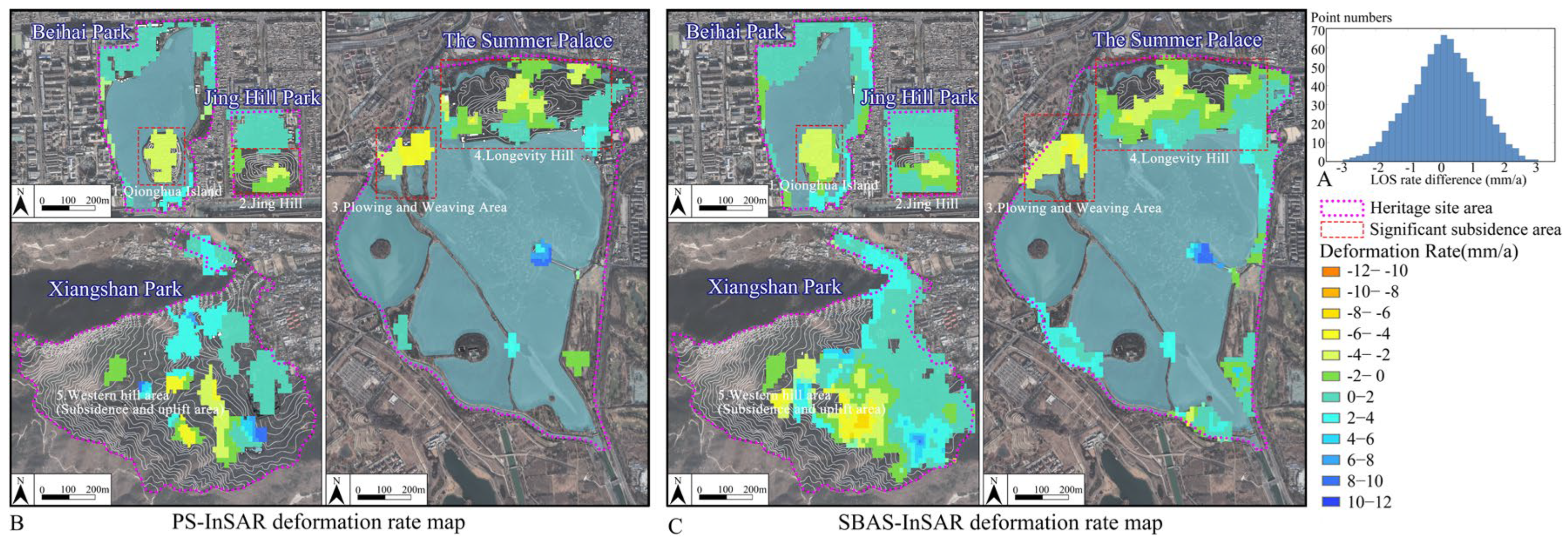
4.1. Comparison of the Land Subsidence Monitoring Results of PS-InSAR and SBAS-InSAR
4.2. Spatial Characteristics of Land Subsidence in Building Heritage Sites
4.3. Analysis of Driving Factors of Land Subsidence
4.3.1. “Excavating Lakes and Piling Hills” Landscape and Environmental Influence

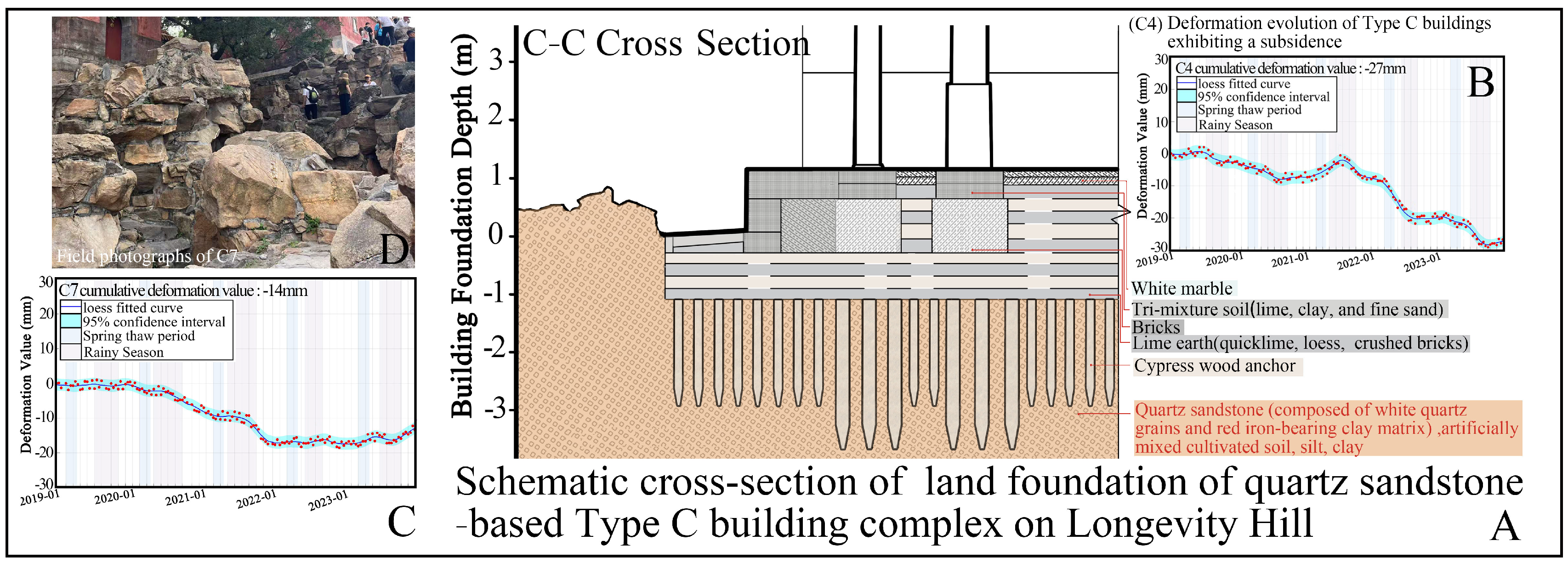
4.3.2. Rock Landscape and Rock Weathering
4.3.3. Terrain-Based Landscape and Slope Instability
5. Conclusions
- This study employs remote sensing technology to monitor the subsidence of landscape heritage sites and analyze influencing factors. By integrating PS-InSAR and SBAS-InSAR techniques, the land subsidence of ancient buildings in four royal gardens in Beijing from 2019 to 2023 was analyzed. The significant subsidence areas identified by both methods are consistent;
- By further analyzing the subsiding areas to the location types of buildings within the heritage sites, it was found that hilly buildings (Type C), waterside buildings (Type A1), and near-water buildings (Type A2) are relatively more prone to subsidence;
- The subsidence of Type C and Type A buildings on islands in Beihai Park, the hills in Jing Hill Park, and the northeastern scenic area in the Summer Palace may be attributed to “excavating lakes and piling hills” construction methods, which led to the presence of thick Holocene sediments in the subsoil of these heritage sites. The land subsidence trends in these areas are influenced by their intrinsic characteristics and environmental factors, such as temperature and rainfall;
- Since the Summer Palace utilizes the rock of Longevity Hill as the foundation for landscape design, Xiangshan Park relies on its steep terrain for scenic construction. The subsidence of hilly building complexes on Longevity Hill may be related to the exposure and weathering-induced detachment of local rock formations. The subsidence of hilly building complexes in the western region of Xiangshan Park may be associated with slope instability;
- While Beijing’s royal gardens represent unique cultural heritage sites created through the modification and utilization of natural landscapes, these activities may lead to land deformation, affecting building complexes under environmental influences such as concentrated rainfall and freeze–thaw phenomenon. Current protective measures for ancient buildings are relatively traditional and lagging. Adopting long-term monitoring using InSAR technology to enhance management is recommended, particularly strengthening observations during the critical periods of March–April thawing and June–September concentrated rainfall;
- In the future, it is hoped that higher-resolution InSAR data can be utilized to enhance the accuracy of long-term deformation monitoring. Additionally, incorporating GNSS data from modern garden sites could further validate InSAR results. It is also recommended to expand the research scope by including contemporary landscape gardens with GNSS measurements to better quantify the uncertainties associated with the detected deformation trends.
Supplementary Materials
Author Contributions
Funding
Data Availability Statement
Conflicts of Interest
References
- Zhou, W. The History of Chinese Classical Gardens; Tsinghua University Press: Beijing, China, 2008. (In Chinese) [Google Scholar]
- Zu, Z. Ying Cheng Jushen Jianggong; Beijing Press: Beijing, China, 2021. (In Chinese) [Google Scholar]
- Pugh, R.S. Briefing: Some observations on the influence of recent climate change on the subsidence of shallow foundations. J. Geotech. Geoenviron. Eng. 2002, 155, 23–25. [Google Scholar] [CrossRef]
- Costa, A.L.; Kok, S.; Korff, M. Systematic assessment of damage to buildings due to groundwater lowering-induced subsidence: Methodology for large scale application in the Netherlands. Proc. IAHS 2020, 382, 577–582. [Google Scholar] [CrossRef]
- Ao, Z.; Hu, X.; Tao, S.; Hu, X.; Wang, G.; Li, M.; Wang, F.; Hu, L.; Liang, X.; Xiao, J.; et al. A national-scale assessment of land subsidence in China’s major cities. Science 2024, 384, 301–306. [Google Scholar] [CrossRef] [PubMed]
- Pei, F.M.; Wei, X.W.; Bowen, Z. Remotely sensing large- and small-scale ground subsidence: A case study of the Guangdong–Hong Kong–Macao Greater Bay Area of China. Remote Sens. Environ. 2019, 232, 111282. [Google Scholar] [CrossRef]
- Chen, B.; Gong, H.; Li, X.; Lei, K.; Ke, Y.; Duan, G.; Zhou, C. Spatial correlation between land subsidence and urbanization in Beijing, China. Nat. Hazards 2015, 75, 2637–2652. [Google Scholar] [CrossRef]
- Si, Y.; Chen, B.; Gong, H.; Gao, M. Temporal and spatial evolution of land subsidence induced by groundwater exploitation and construction in the eastern Chaoyang District, Beijing, China. J. Indian Soc. Remote Sens. 2018, 46, 1657–1665. [Google Scholar] [CrossRef]
- Zhou, C.; Gong, H.; Zhang, Y.; Warner, T.; Wang, C. Spatiotemporal evolution of land subsidence in the Beijing plain 2003–2015 using persistent scatterer interferometry (PSI) with multi-source SAR data. Remote Sens. 2018, 10, 552. [Google Scholar] [CrossRef]
- Du, Z.; Ge, L.; Ng, A.H.M.; Xiaojing, L.; Li, L. Mapping land subsidence over the eastern Beijing city using satellite radar interferometry. Int. J. Digit. Earth 2018, 11, 504–519. [Google Scholar] [CrossRef]
- Chen, B.; Gong, H.; Chen, Y.; Li, X.; Zhou, C.; Lei, K.; Zhu, L.; Duan, L.; Zhao, X. Land subsidence and its relation with groundwater aquifers in Beijing Plain of China. Sci. Total Environ. 2020, 735, 139111. [Google Scholar] [CrossRef]
- Zhang, J.; Liu, H.; Sun, X.; Liu, S. Processing of building subsidence monitoring data based on fusion Kalman filtering algorithm. Alex. Eng. J. 2021, 60, 3353–3360. [Google Scholar] [CrossRef]
- Sui, L.; Zhu, H.; Fang, C.; Zhai, S. Ground fissure monitoring based on 3D terrestrial laser scanning techniques. In Proceedings of the 2017 7th International Conference on Manufacturing Science and Engineering (ICMSE 2017); Atlantis Press: Dordrecht, The Netherlands, 2017; pp. 67–71. [Google Scholar] [CrossRef]
- Pesci, A.; Casula, G.; Boschi, E. Laser scanning the Garisenda and Asinelli towers in Bologna (Italy): Detailed deformation patterns of two ancient leaning buildings. J. Cult. Herit. 2011, 12, 117–127. [Google Scholar] [CrossRef]
- Bonali, E.; Pesci, A.; Casula, G.; Boschi, E. Deformation of ancient buildings inferred by terrestrial laser scanning methodology: The Cantalovo church case study (Northern Italy). Archaeometry 2014, 56, 703–716. [Google Scholar] [CrossRef]
- Dzurisin, D.; Lu, Z. Interferometric synthetic-aperture radar (InSAR). In Volcanol Deformation: Geodetic Monitoring Techniques; Dzurisin, D., Ed.; Springer: Berlin/Heidelberg, Germany, 2007; pp. 153–194. [Google Scholar] [CrossRef]
- Yang, K.; Yan, L.; Huang, G.; Chen, C.; Wu, Z. Monitoring building deformation with InSAR: Experiments and validation. Sensors 2016, 16, 2182. [Google Scholar] [CrossRef]
- Yan, H.; Dai, W.; Xu, W.; Shi, Q.; Sun, K.; Lu, Z.; Wang, R. A method for correcting InSAR interferogram errors using GNSS data and the K-means algorithm. Earth Planets Space 2024, 76, 51. [Google Scholar] [CrossRef]
- Luo, K.; Zhang, Z.; He, Y. Improved registration algorithm for SAR image based on stable point of PS-InSAR. In Proceedings of the International Conference on Electronic Information Engineering and Computer Communication (EIECC 2021), Nanchang, China, 17–19 December 2021; SPIE: Bellingham, WA, USA, 2022; Volume 12172. [Google Scholar]
- Lu, Z. Interferometric synthetic aperture radar: Building tomorrow’s tools today. Alsk. Satell. Facil. News Notes 2006, 15, 12–14. [Google Scholar]
- Ng, A.H.M.; Liu, Z.; Du, Z.; Huang, H.; Wang, H.; Ge, L. A novel framework for combining polarimetric Sentinel-1 InSAR time series in subsidence monitoring—A case study of Sydney. Remote Sens. Environ. 2023, 295, 113694. [Google Scholar] [CrossRef]
- Tapete, D.; Cigna, F. InSAR data for geohazard assessment in UNESCO World Heritage sites: State-of-the-art and perspectives in the Copernicus era. Int. J. Appl. Earth Obs. Geoinf. 2017, 63, 24–32. [Google Scholar] [CrossRef]
- Chen, F.; Zhou, W.; Tang, Y.; Li, R.; Lin, H.; Balz, T.; Luo, J.; Shi, P.; Zhu, M.; Fang, C. Remote sensing-based deformation monitoring of pagodas at the Bagan cultural heritage site, Myanmar. Int. J. Digit. Earth 2022, 15, 770–788. [Google Scholar] [CrossRef]
- Sousa, J.J.; Lin, J.; Wang, Q.; Liu, G.; Fan, J.; Bai, S.; Zhao, H.; Pan, H.; Wei, W.; Rittlinger, V.; et al. Using machine learning and satellite data from multiple sources to analyze mining, water management, and preservation of cultural heritage. Geo-Spat. Inf. Sci. 2024, 27, 552–571. [Google Scholar] [CrossRef]
- Ge, Y.; Liu, Y.; Cong, Y.; Hu, Z.; Feng, J. Surface soil fertility quality evaluation of green land in the Summer Palace. J. Nanjing For. Univ. 2023, 47, 182. [Google Scholar]
- Chen, R.; Lu, R. Dry Tropical Nights and Wet Extreme Heat in Beijing: Atypical Configurations Between High Temperature and Humidity. Mon. Weather Rev. 2014, 142, 1792–1802. [Google Scholar] [CrossRef]
- Wang, X.; Chen, R. Freezing and thawing characteristics of seasonally frozen ground across China. Geoderma 2024, 448, 116966. [Google Scholar] [CrossRef]
- Zhang, B. Architectural Family Yangshi Lei; Beijing Press: Beijing, China, 2018. [Google Scholar]
- Lou, Q. Twenty Lectures on Ancient Chinese Architecture; Sanlian Publishing Press: Hong Kong, China, 2004. [Google Scholar]
- Li, Y.; Yang, K.; Hou, Z.; Zhang, J.; Hou, Z.; Wang, S.; Ding, X. Research on Time Series InSAR Monitoring Method for Multiple Types of Surface Deformation in Mining Area. Nat. Hazards 2022, 114, 2479–2508. [Google Scholar]
- Osmanoğlu, B.; Sunar, F.; Wdowinski, S.; Cabral-Cano, E. Time series analysis of InSAR data: Methods and trends. ISPRS J. Photogramm. 2016, 115, 90–102. [Google Scholar] [CrossRef]
- Ferretti, A.; Monti-Guarnieri, A.; Prati, C.; Rocca, F.; Massonnet, D. InSAR Principles: Guidelines for SAR Interferometry Processing and Interpretation; European Space Agency: Noordwijk, The Netherlands, 2007; Volume 19, ISBN 92-9092-233-8. Available online: https://ui.adsabs.harvard.edu/abs/2007ESATM..19.....F/abstract (accessed on 1 February 2025).
- Xia, Y. Synthetic aperture radar interferometry. In Sciences of Geodesy-I: Advances and Future Directions; Xu, G., Ed.; Springer: Berlin/Heidelberg, Germany, 2010; pp. 415–474. [Google Scholar] [CrossRef]
- Ferretti, A.; Prati, C.; Rocca, F. Permanent scatterers in SAR interferometry. IEEE Trans. Geosci. Remote Sens. 2001, 39, 8–20. [Google Scholar] [CrossRef]
- Mao, W.; Zhang, J.; Li, C.; Gao, J.Z.; Xie, W.; Xu, Y. Quality inspection of surface deformation monitoring results based on PS-Insar Technology. ISPRS Ann. Photogramm. Remote Sens. Spat. Inf. Sci. 2022, 3, 597–602. [Google Scholar] [CrossRef]
- Ferretti, A.; Prati, C.; Rocca, F. Nonlinear subsidence rate estimation using permanent scatters in differential SAR interferometry. IEEE Trans. Geosci. Remote Sens. 2000, 38, 2202–2212. [Google Scholar] [CrossRef]
- Berardino, P.; Fornaro, G.; Lanari, R. A new algorithm for surface deformation monitoring based on small baseline differential SAR interferograms. IEEE Trans. Geosci. Remote Sens. 2002, 40, 2375–2383.10. [Google Scholar]
- Li, S.; Xu, W.; Li, Z. Review of the SBAS InSAR time-series algorithms, applications, and challenges. Geod. Geodyn. 2022, 13, 114–126. [Google Scholar] [CrossRef]
- Tao, Q.; Wang, F.; Guo, Z.; Hu, L.; Yang, C.; Liu, T. Accuracy verification and evaluation of small baseline subset (SBAS) interferometric synthetic aperture radar (InSAR) for monitoring mining subsidence. Eur. J. Remote Sens. 2021, 54, 642–663. [Google Scholar] [CrossRef]
- Ma, Y.; Yue, S.; Xu, H.; Zhang, P. Evidence in Stratum for Shichahai Becoming Lake from Han-Dynasty to Yuan-Dynasty: A Case of the Southern Section at the Western Side of Building Site in Xiaoshibei Hutong. Acta Sci. Nat. Univ. Pekin. 2015, 51, 451. [Google Scholar]
- Liang, S.C. The Construction Methods and Regulations of the Qing Ministry of Works; Qing Dynasty Ministry of Works; Commercial Press: Beijing, China, 1982. [Google Scholar]
- Huang, C.; Pu, Q.; Ji, C.; Pang, Q.; Liu, Y.; Kong, Z.; Min, L.; Shen, G.; Liu, C.; Zhai, X. Research on the Sediments of Kunming Lake in the Summer Palace over the Past 3500 Years; Ocean Press: Beijing, China, 1996. [Google Scholar]
- Yao, J.; Yao, X.; Liu, X. Landslide Detection and Mapping Based on SBAS-InSAR and PS-InSAR: A Case Study in Gongjue County, Tibet, China. Remote Sens. 2022, 14, 4728. [Google Scholar] [CrossRef]
- Zhang, Z.; Hu, C.; Wu, Z.; Zhang, Z.; Yang, S.; Yang, W. Monitoring and analysis of ground subsidence in Shanghai based on PS-InSAR and SBAS-InSAR technologies. Sci. Rep. 2023, 13, 8031. [Google Scholar] [CrossRef]
- Li, Y.; Zuo, X.; Yang, F.; Bu, J.; Wu, W.; Liu, X. Effectiveness Evaluation of DS-InSAR Method Fused PS Points in Surface Deformation Monitoring: A Case Study of Hongta District, Yuxi City, China. Geomat. Nat. Hazards Risk 2023, 14, 2176011. [Google Scholar] [CrossRef]
- Nappo, N.; Peduto, D.; Polcari, M.; Livio, F.; Ferrario, M.F.; Comerci, V.; Stramondo, S.; Michetti, A.M. Subsidence in Como historic centre (northern Italy): Assessment of building vulnerability combining hydrogeological and stratigraphic features, Cosmo-SkyMed InSAR and damage data. Int. J. Disaster Risk Reduc. 2021, 56, 102115. [Google Scholar] [CrossRef]
- Ferrario, M.F.; Bonadeo, L.; Brunamonte, F.; Livio, F.; Martinelli, E.; Michetti, A.M.; Censi Neri, P.; Chiessi, V.; Comerci, V.; Höbig, N. Late Quaternary environmental evolution of the Como urban area (Northern Italy): A multidisciplinary tool for risk management and urban planning. Eng. Geol. 2015, 193, 384–401. [Google Scholar]
- Meckel, T.A.; ten Brink, U.S.; Williams, S.J. Current Subsidence Rates Due to Compaction of Holocene Sediments in Southern Louisiana. Geophys. Res. Lett. 2006, 33. [Google Scholar] [CrossRef]
- Liu, Y.; Liu, J.; Xia, X.; Bi, H.; Huang, H.; Ding, R.; Zhao, L. Land Subsidence of the Yellow River Delta in China Driven by River Sediment Compaction. Sci. Total Environ. 2021, 750, 142165. [Google Scholar] [CrossRef]
- Amorosi, A.; Pacifico, A.; Rossi, V.; Ruberti, D. Late Quaternary Incision and Deposition in an Active Volcanic Setting: The Volturno Valley Fill, Southern Italy. Sediment. Geol. 2012, 282, 307–320. [Google Scholar] [CrossRef]
- Gruber, S. Ground Subsidence and Heave Over Permafrost: Hourly Time Series Reveal Interannual, Seasonal, and Shorter-Term Movement Caused by Freezing, Thawing, and Water Movement. Cryosphere 2020, 14, 1437–1447. [Google Scholar] [CrossRef]
- Cao, Q.; Zhang, Y.; Yang, L.; Chen, J.; Hou, C. Unveiling the Driving Factors of Urban Land Subsidence in Beijing, China. Sci. Total Environ. 2024, 916, 170134. [Google Scholar] [CrossRef]
- Dai, K.; Shi, X.; Gou, J.; Hu, L.; Chen, M.; Zhao, L.; Dong, X.; Li, Z. Diagnosing Subsidence Geohazard at Beijing Capital International Airport, from High-Resolution SAR Interferometry. Sustainability 2020, 12, 2269. [Google Scholar] [CrossRef]
- Raspini, F.; Loupasakis, C.; Rozos, D.; Adam, N.; Moretti, S. Ground subsidence phenomena in the Delta municipality region (Northern Greece): Geotechnical modeling and validation with Persistent Scatterer Interferometry. Int. J. Appl. Earth Obs. Geoinf. 2014, 28, 78–89. [Google Scholar] [CrossRef]
- Guo, H.; Zhang, Z.; Cheng, G.; Li, W.; Li, T.; Jiao, J.J. Groundwater-derived land subsidence in the North China Plain. Environ. Earth Sci. 2015, 74, 1415–1427. [Google Scholar] [CrossRef]
- Kasai, M.; Ikeda, M.; Asahina, T.; Fujisawa, K. LiDAR-Derived DEM Evaluation of Deep-Seated Landslides in a Steep and Rocky Region of Japan. Geomorphology 2009, 113, 57–69. [Google Scholar] [CrossRef]
- Liu, Y.; Wang, X.; Wen, Q.; Zhu, N. Identifying Sources and Variations of Organic Matter in an Urban River in Beijing, China Using Stable Isotope Analysis. Ecol. Indic. 2019, 102, 783–790. [Google Scholar] [CrossRef]
- Fakhri, F.; Kalliola, R. Monitoring ground deformation in the settlement of Larissa in Central Greece by implementing SAR interferometry. Nat. Hazards 2015, 78, 1429–1445. [Google Scholar] [CrossRef]
- Burnol, A.; Foumelis, M.; Gourdier, S.; Deparis, J.; Raucoules, D. Monitoring of Expansive Clays Over Drought-Rewetting Cycles Using Satellite Remote Sensing. Atmosphere 2021, 12, 1262. [Google Scholar] [CrossRef]
- Hazirbaba, K. Effects of freeze-thaw on settlement of fine grained soil subjected to cyclic loading. Cold Reg. Sci. Technol. 2019, 160, 222–229. [Google Scholar] [CrossRef]
- Wang, Z.; Cao, C.; Yu, Q.; Wang, Q.; Niu, C.; Shen, J.; Zhu, K.; Liu, J.; Han, M.; Fu, H.; et al. Multi-Scale Failure Mechanisms of Hydraulic Engineering Exposed to Seasonally Frozen Salinization Environment: Integrating SBAS-InSAR and Mechanical Experiments. Sci. Total Environ. 2024, 912, 169210. [Google Scholar] [CrossRef]
- Matano, F.; Sacchi, M.; Vigliotti, M.; Ruberti, D. Subsidence Trends of Volturno River Coastal Plain (Northern Campania, Southern Italy) Inferred by SAR Interferometry Data. Geosciences 2018, 8, 8. [Google Scholar] [CrossRef]
- Cleveland, W.S. Robust locally weighted regression and smoothing scatterplots. J. Am. Stat. Assoc. 1979, 74, 829–836. [Google Scholar] [CrossRef]
- Zambanini, C.; Reinprecht, V.; Kieffer, D.S. InSARTrac Field Tests—Combining Computer Vision and Terrestrial InSAR for 3D Displacement Monitoring. Remote Sens. 2023, 15, 2031. [Google Scholar] [CrossRef]
- Bai, J. The Study of Planting Design of Longevity Hill of the Summer Palace; Chinese Academy of Sciences, The Forestry Summer Palace Management Office: Beijing, China, 2014. [Google Scholar]
- Yang, J.; Qin, J.; Ba, Z.; Zhang, L.; Liu, Y. Physical-mechanical test and mineral analysis of rock forming longevity hill of Summer Palace, Beijing. J. Eng. Geol. 2016, 24, 292–298. [Google Scholar]
- Kun, H.; Xiong, X. (Eds.) Civil Engineering Geology; Beijing Institute of Technology Press: Beijing, China, 2017. [Google Scholar]
- Hong, S. Engineering Geology; Shanghai Jiao Tong University Press: Shanghai, China, 2023. [Google Scholar]
- Chen, W.; Liao, R.; Wang, N.; Zhang, J. Effects of experimental frost–thaw cycles on sandstones with different weathering degrees: A case from the Bingling Temple Grottoes, China. Bull. Eng. Geol. Environ. 2019, 78, 5311–5326. [Google Scholar] [CrossRef]
- Li, L.; Shao, M.; Wang, S.; Li, Z. Preservation of earthen heritage sites on the Silk Road, northwest China from the impact of the environment. Environ. Earth Sci. 2011, 64, 1625–1639. [Google Scholar] [CrossRef]
- Shao, M.; Zhang, Z.; Li, L. Properties and Deterioration Mechanism of Sandstone Blocks in Chengde Royal Buildings Between 1703 and 1792. J. Eng. Geol. 2015, 23, 533–538. [Google Scholar] [CrossRef]
- Sun, B.; Li, X.; Cui, K.; Hong, J.; Chen, R.; Jia, C.; Peng, N. Experimental Study on the Effects of Hydrochemistry and Periodic Changes in Temperature and Humidity on Sandstone Weathering in the Longshan Grottoes. Heritage Sci. 2023, 11, 173. [Google Scholar] [CrossRef]
- Guo, F.; Jiang, G. Investigation into rock moisture and salinity regimes: Implications of sandstone weathering in Yungang Grottoes, China. Carbonates Evaporites 2015, 30, 1–11. [Google Scholar] [CrossRef]
- Gao, B.; Zhang, J.; Liao, X.; Zhang, H.; Ye, C. Stability analysis and prevention measures of rock slope in mountain scenic area. J. Eng. Geol. 2022, 30, 1316–1324. [Google Scholar] [CrossRef]
- Xia, C.-A.; Zhang, J.-Q.; Wang, H.; Jian, W.-B. Global Sensitivity Analysis of Slope Stability Considering Effective Rainfall with Analytical Solutions. Water 2025, 17, 141. [Google Scholar] [CrossRef]
- Tian, W.; Peiffer, H.; Malengier, B.; Liu, G.; Cheng, Q. Numerical Investigation of Rainfall Infiltration-Induced Slope Stability Considering Water-Air Two-Phase Flow; IntechOpen: London, UK, 2024. [Google Scholar] [CrossRef]
- Makabayi, B.; Musinguzi, M.; Otukei, J.R. Estimation of Ground Vertical Displacement in Landslide Prone Areas Using PS-InSAR: A Case Study of Bududa, Uganda. Int. J. Geosci. 2021, 12, 108701. [Google Scholar] [CrossRef]
- Zhang, Z.; Yang, X.; Ye, F.; Zhou, H.; Zhang, T. Microscopic Characteristics of Petrography and Discussion on Weathering Mechanism of Fangshan Marble in Beijing. J. Eng. Geol. 2015, 23, 279–286. [Google Scholar] [CrossRef]
- Wang, X.; Meng, Q.; Liu, X.; Allam, M.; Zhang, L.; Hu, X.; Bi, Y.; Jancsó, T. Evaluation of Fairness of Urban Park Green Space Based on an Improved Supply Model of Green Space: A Case Study of Beijing Central City. Remote Sens. 2022, 15, 244. [Google Scholar] [CrossRef]
- Singh, H.; Huat, B.B.K.; Jamaludin, S. Slope Assessment Systems: A Review and Evaluation of Current Techniques Used for Cut Slopes in the Mountainous Terrain of West Malaysia. Electron. J. Geotech. Eng. 2008, 13, 1–24. [Google Scholar]
- Migoń, P.; Jancewicz, K.; Różycka, M.; Duszyński, F.; Kasprzak, M. Large-Scale Slope Remodelling by Landslides–Geomorphic Diversity and Geological Controls, Kamienne Mts., Central Europe. Geomorphology 2017, 289, 134–151. [Google Scholar] [CrossRef]
- Ren, P. Analysis of Geothermal Conditions in the Xiangshan Area of Beijing and the Study of the Relationship Between Drilling Speed and Stratigraphy. Master’s Thesis, China University of Geosciences, Beijing, China, 2006. [Google Scholar]
- Harris, C.; Smith, J.S.; Davies, M.C.R.; Rea, B. An Investigation of Periglacial Slope Stability in Relation to Soil Properties Based on Physical Modelling in the Geotechnical Centrifuge. Geomorphology 2008, 93, 437–459. [Google Scholar] [CrossRef]
- Liu, H.; Yang, Y.; Zhang, K.; Sun, C. Soil Erosion as Affected by Freeze-Thaw Regime and Initial Soil Moisture Content. Soil Sci. Soc. Am. J. 2017, 81, 859–869. [Google Scholar] [CrossRef]


Disclaimer/Publisher’s Note: The statements, opinions and data contained in all publications are solely those of the individual author(s) and contributor(s) and not of MDPI and/or the editor(s). MDPI and/or the editor(s) disclaim responsibility for any injury to people or property resulting from any ideas, methods, instructions or products referred to in the content. |
© 2025 by the authors. Licensee MDPI, Basel, Switzerland. This article is an open access article distributed under the terms and conditions of the Creative Commons Attribution (CC BY) license (https://creativecommons.org/licenses/by/4.0/).
Share and Cite
Cui, J.; Cui, S.; Zhang, J.; Sun, F. Spatial Characteristics of Land Subsidence in Architectural Heritage Sites of Beijing’s Royal Gardens Based on Remote Sensing. Heritage 2025, 8, 113. https://doi.org/10.3390/heritage8040113
Cui J, Cui S, Zhang J, Sun F. Spatial Characteristics of Land Subsidence in Architectural Heritage Sites of Beijing’s Royal Gardens Based on Remote Sensing. Heritage. 2025; 8(4):113. https://doi.org/10.3390/heritage8040113
Chicago/Turabian StyleCui, Jingshu, Shan Cui, Junhua Zhang, and Fuhao Sun. 2025. "Spatial Characteristics of Land Subsidence in Architectural Heritage Sites of Beijing’s Royal Gardens Based on Remote Sensing" Heritage 8, no. 4: 113. https://doi.org/10.3390/heritage8040113
APA StyleCui, J., Cui, S., Zhang, J., & Sun, F. (2025). Spatial Characteristics of Land Subsidence in Architectural Heritage Sites of Beijing’s Royal Gardens Based on Remote Sensing. Heritage, 8(4), 113. https://doi.org/10.3390/heritage8040113