

Databases and Information Models for Semantic and Evolutionary Analysis in Fortified Cultural Heritage

Abstract
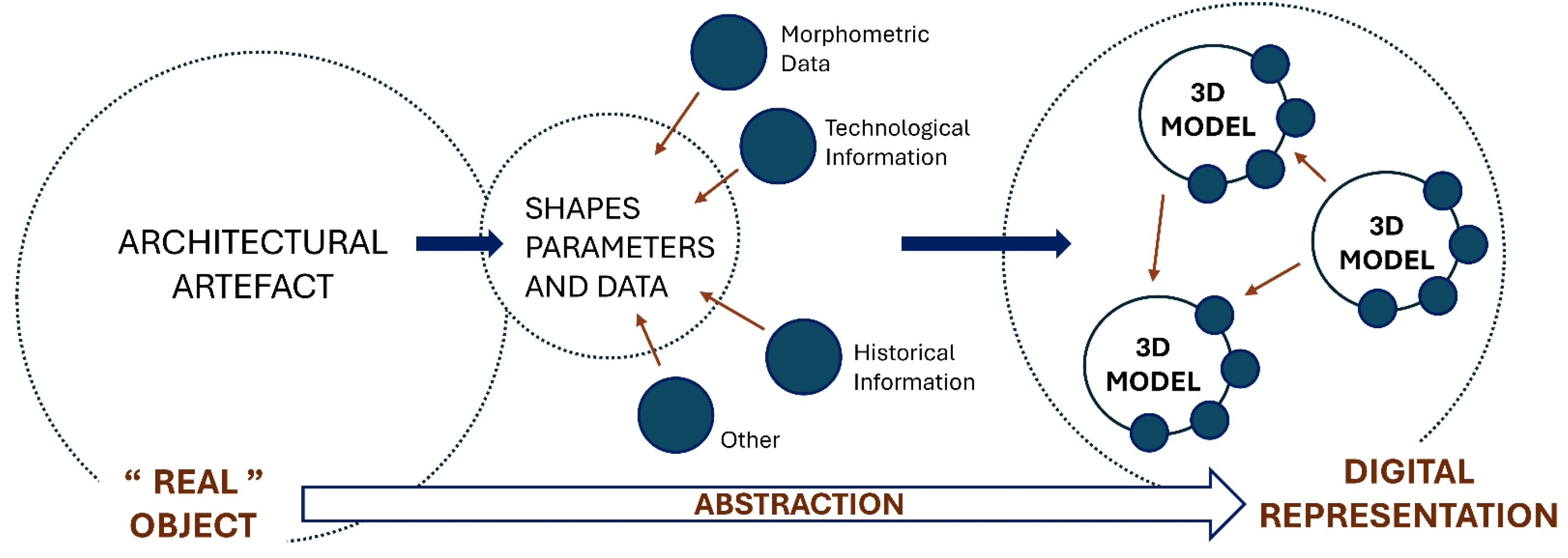
1. Introduction
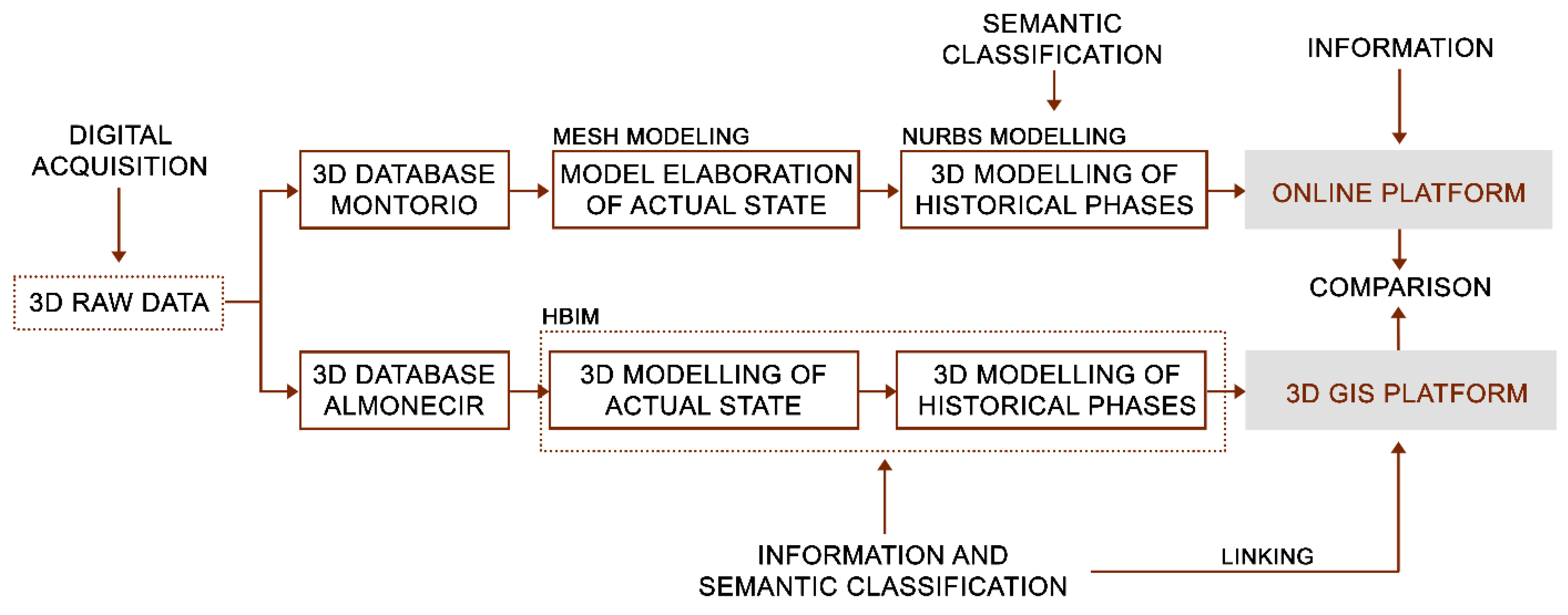
2. Materials and Methods
2.1. Acquisition Methodologies Through Integrated Fast-Survey Techniques
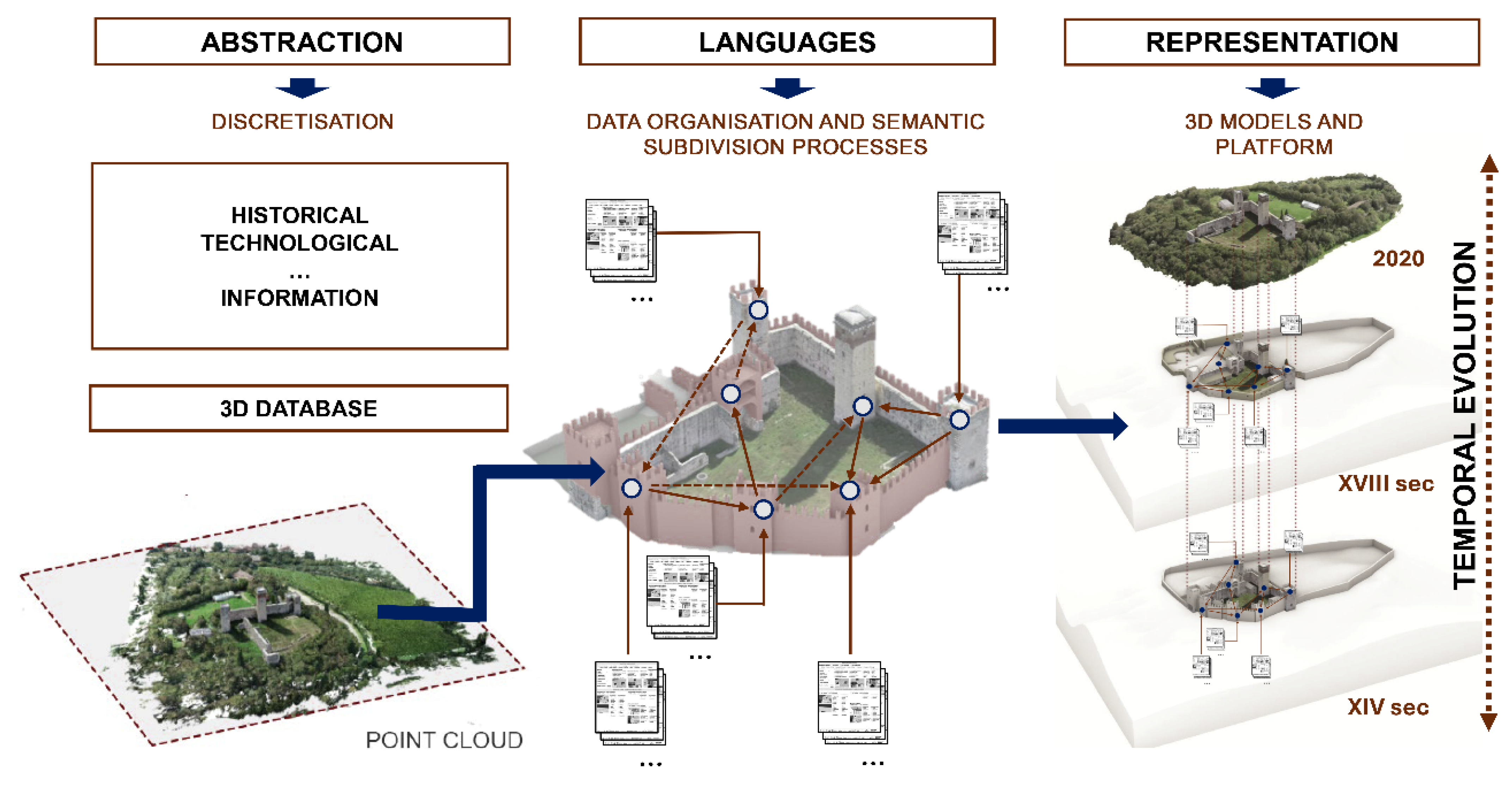
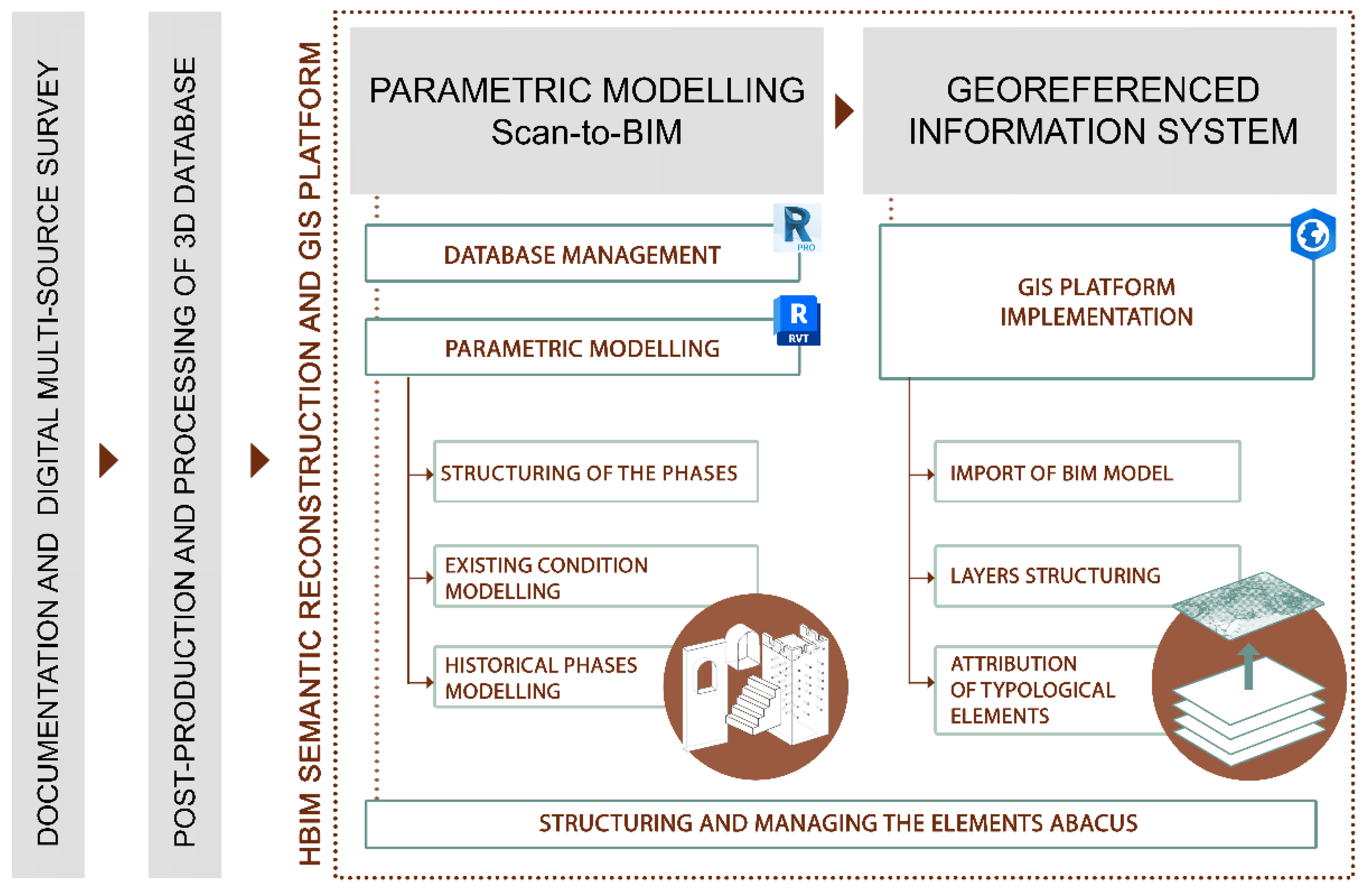
2.2. Three-Dimensional Modelling Processes and Structuring of Evolutionary Stages
- -
- The hybrid modelling of evolutionary phases (mesh-nurbs), in which a macro-semantic subdivision was structured.
- -
- The parametric modelling of evolutionary hypotheses (HBIM), where a micro-semantic breakdown was developed.
- -
- The shapes, geometries, and relative level of detail of the corresponding architectural component.
- -
- The building type to which the element belongs and its function.
- -
- The identification of each element’s position within the overall architectural complex.
- -
- The historical phase of construction and/or affiliation.
- -
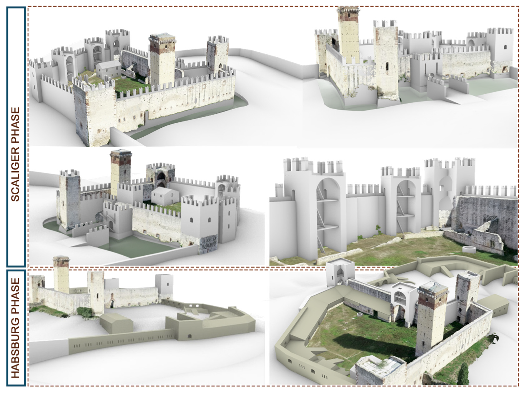
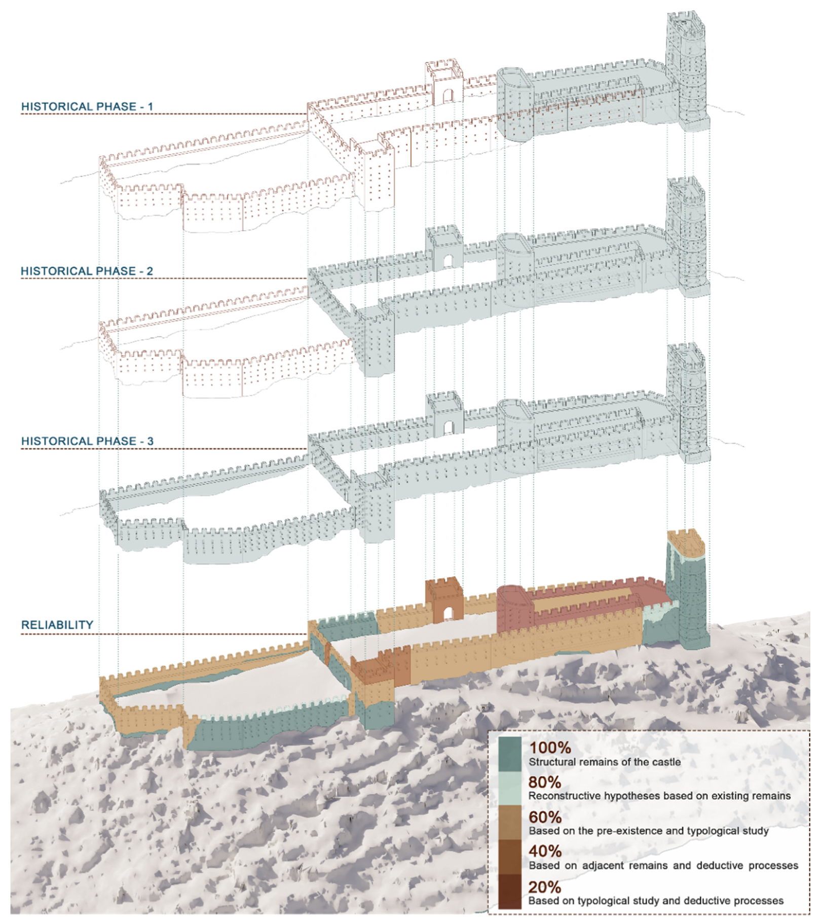
- In the first case study, reconstruction is addressed on a macroscopic level, divided by structures (towers, ramparts, ravelin, etc.) and starting from historical source analysis, which provides a certain level of reliability. The systematised information and documentary apparatus were associated only after the model was structured.
- -
- In the second case, reconstruction is treated more in detail, requiring the structuring of thematic layers to highlight, through colour scales, aspects related to reliability. In this instance, data were associated during the modelling phase.
2.3. Montorio Castle: Macro-Reconstruction of Evolutionary Phases Through Historical Sources
- -
- Collecting and analysing documentary sources and iconographic material for extracting information on artefact consistency (geometric form, surface appearance, and physical characteristics) and the interpretation of remains;
- -
- Correlation between the data used in the reconstruction process and the level of uncertainty in each constituent element;
- -
- Automated 3D model reconstruction of the castle’s actual state;
- -
- Freeform modelling for historical phases, adapting basic geometric primitives to represent architectural features for the semantic enrichment of models;
- -
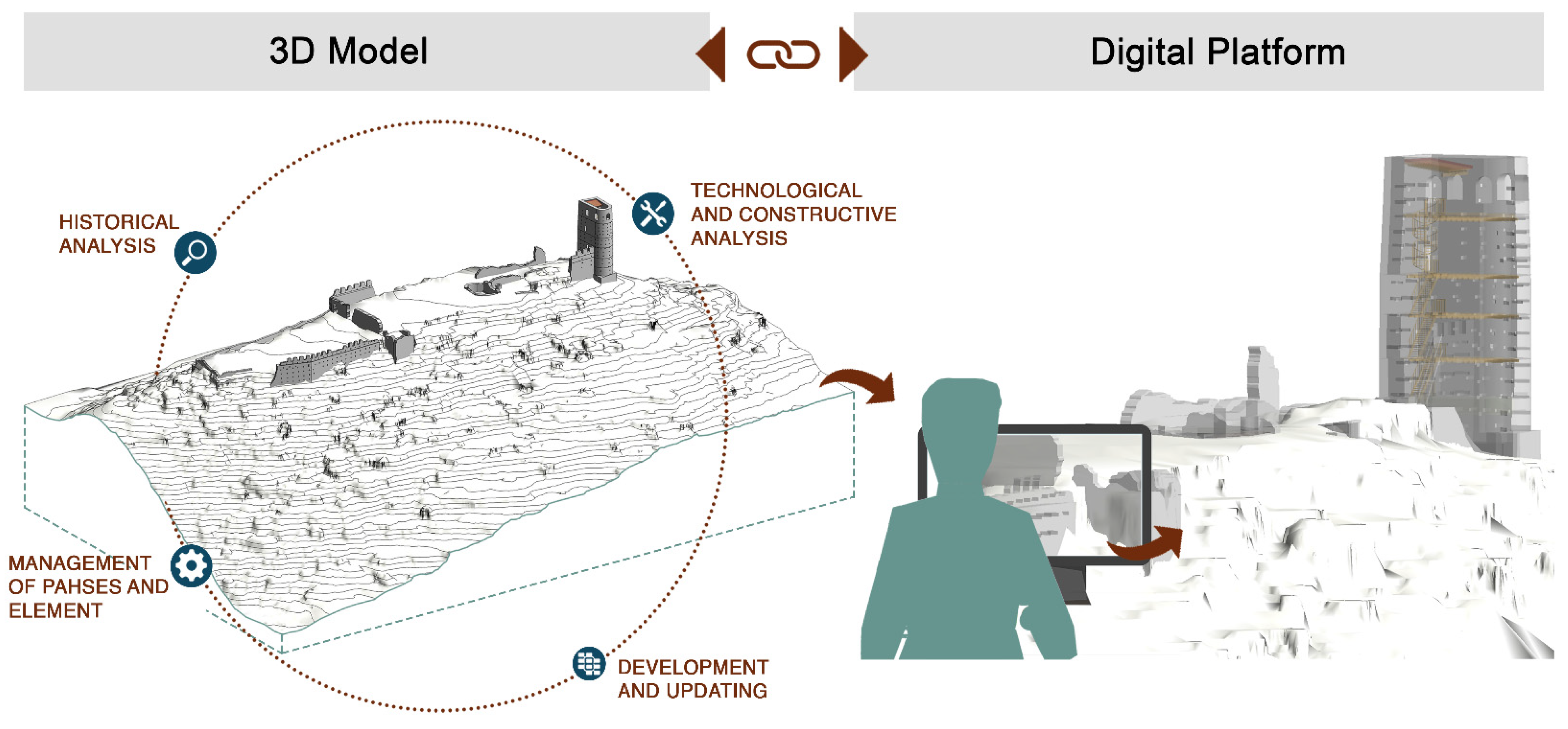
- The validation of evolutionary reconstructions and the subsequent development and design of a platform for its visualisation.
- -
- Definition: modelling of the entities that exist in the examined temporal state but are absent in the current or past states;
- -
- Editing: the geometric entities already present within an evolutionary state were adapted to the state under examination through splitting, merging, or deforming the geometric entities based on the visual appearance in the analysed source;
- -
- Removal: in the transition from modelling one phase to another, all entities not present in the examined temporal state were deleted.
2.3.1. Macro-Reconstruction of the Scaliger Phases
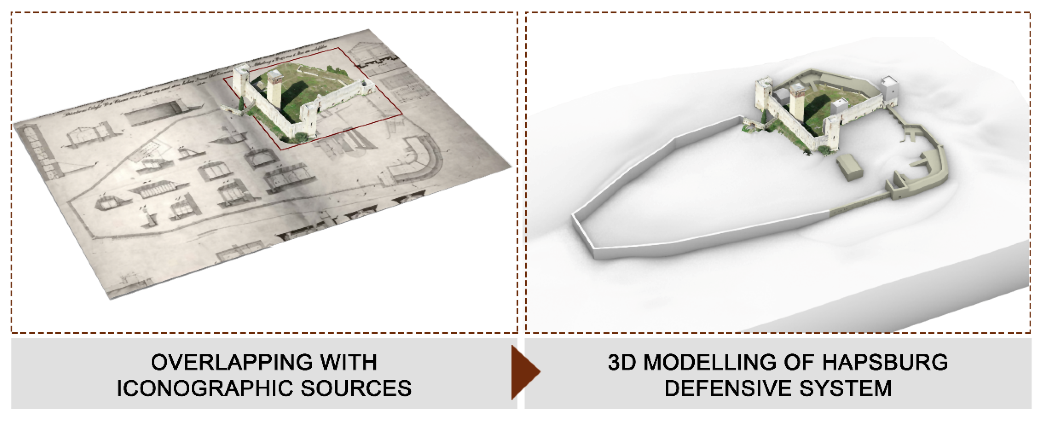
2.3.2. Macro-Reconstruction of the Habsburg Phases
2.4. The Castle of Almonecir: Micro-Level Reconstruction Hypotheses Based on Evidence
- -
- Analysis of archaeological evidence and interpretation processes;
- -
- Analysing contemporary case studies and interpretative processes to define the main characteristics of the structure (geometric shape, surface appearance, and physical characteristics);
- -
- Correlation between the data used in the reconstruction process and the level of uncertainty characterising each constitutive element;
- -
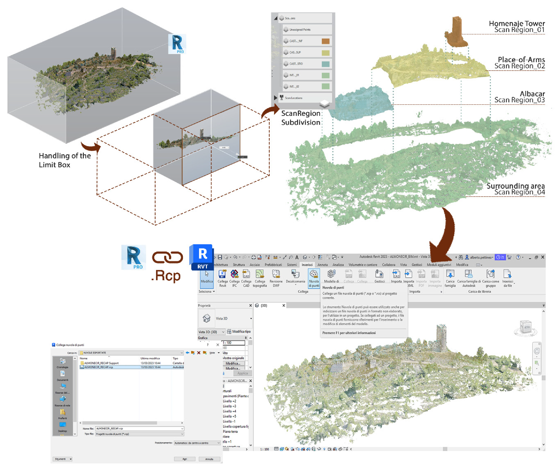
- 3D reconstruction of the phases (including the current state) through scan-to-BIM;
- -
- Validation of evolutionary hypotheses and subsequent design of a platform for visualisation.
- -
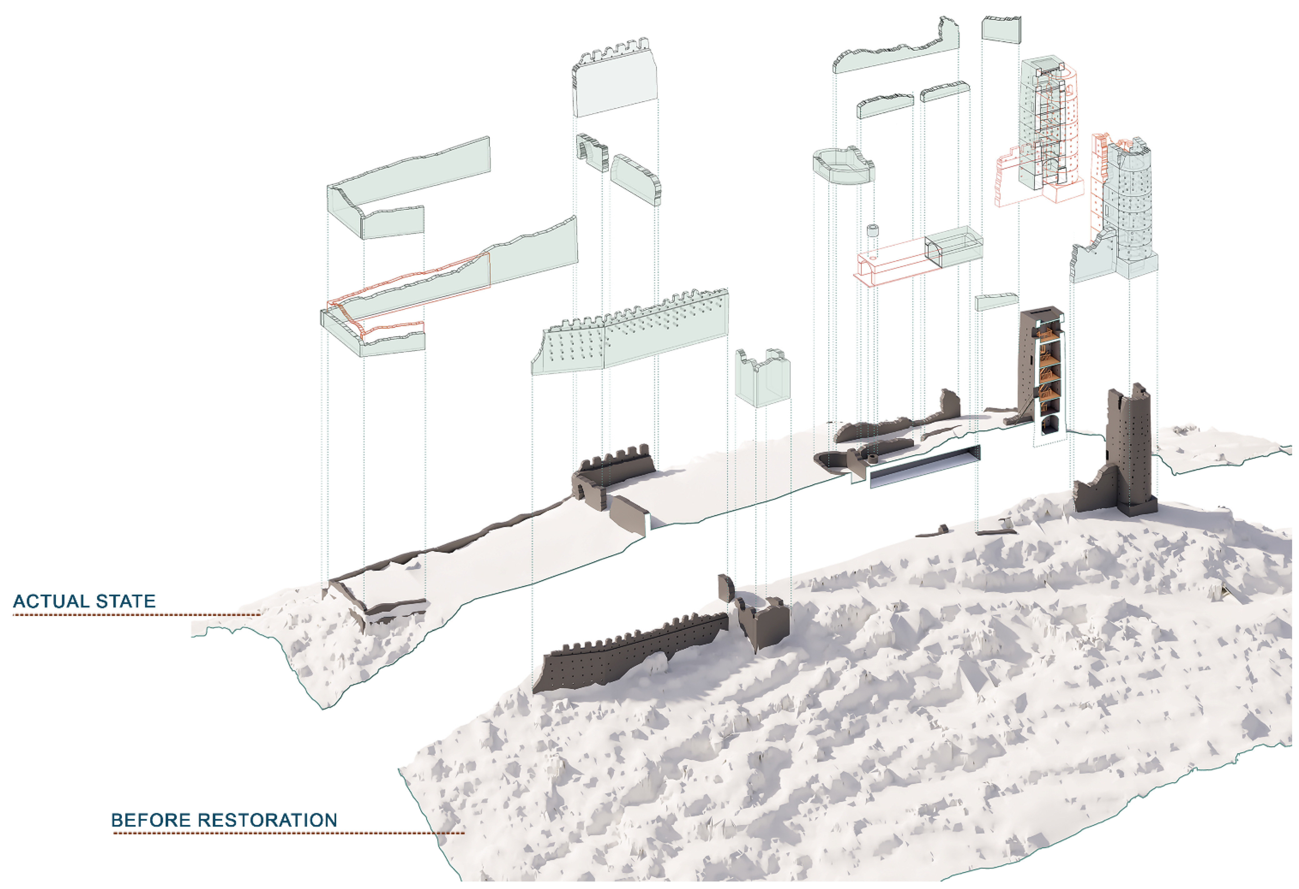
- The current state of the castle;
- -
- The castle before restoration and consolidation interventions;
- -
- The expansions of the castle and the Albacar (14th–15th century);
- -
- The castle during the time of Jaime I (12th–13th century);
- -
- The first fortified structure: the Arab ribat (9th–11th century).
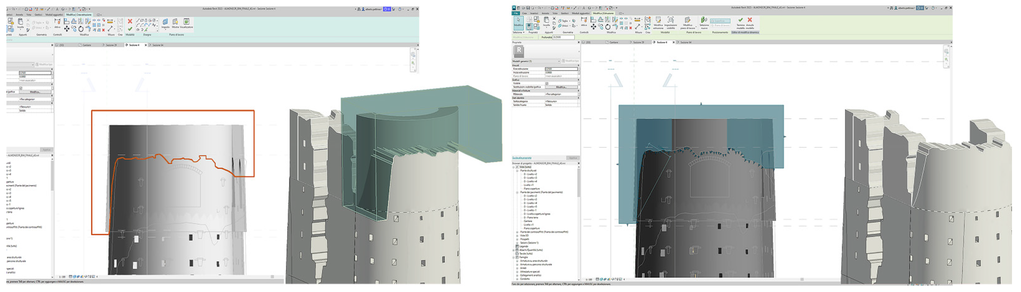
2.4.1. Micro-Reconstruction of the Actual State of the Castle
- -
- Definition and positioning of walls using the tracing tools available in the software;
- -
- Using the “Modify Wall” command, the irregular profile characteristics of the castle walls were traced in place;
- -
- The walls are equipped with accessory elements, such as putlog holes or openings, which are added by creating and positioning specially parameterised components.
- -
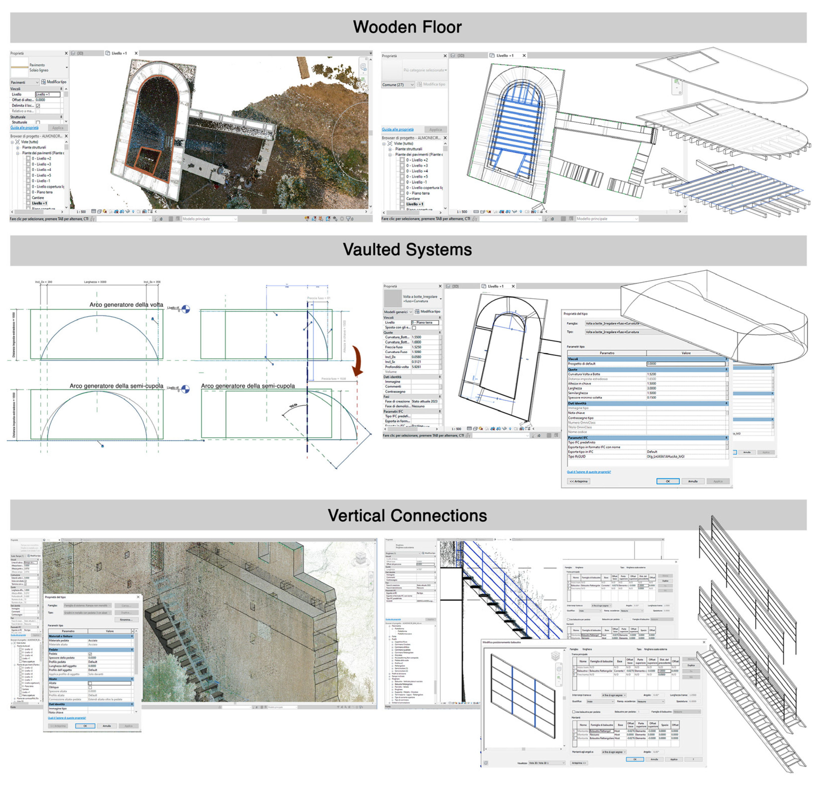
- Definition of properties and creation of in-place profiles for the slabs using the available tracing tools in the software;
- -
- Definition of properties and creation of in-place profiles for areas with continuity solutions in the floors meant to host vertical connections, given that they had diverse and challenging shapes to standardise;
- -
- Definition of the supporting structure of the timber floor through a beam system.
- -
- Using the same method as wooden floors, properties were defined for each slab, followed by in-place modification of the extrusion profile using available tracing tools;
- -
- Creation of vaults as components through the definition of a local model. After studying the vault type, its shape and profiles were parameterised to allow model adaptation;
- -
- Placement of components within the slab. The model modification parameters were adjusted by controlling adherence to the point cloud data in place.
- -
- Placement process follows the same approach used for walls and floors. The definition and positioning were carried out from a parametric system family, adapting the object to the point cloud by controlling the ramp’s direction and length parameters;
- -
- Editing and defining accessory parameters such as the number and height of the treads, adapting the modelled stairs to those present on site;
- -
- Addition of the parametric components of the railing and handrail already available in the Revit library. Based on the point cloud data, parameters were set to define the overall dimensions of the balustrade components, such as the number and spacing of vertical elements and total height.
2.4.2. The Reconstruction of the Castle Phase Before the Consolidation Works
2.4.3. The Reconstruction of Historical Phases and the Development of Reliability Scales
- -
- Highlight inconsistencies in the documentation or its interpretation;
- -
- Display the level of incompleteness in the study;
- -
- Providing insights based on knowledge gained about a predefined object.
3. Results
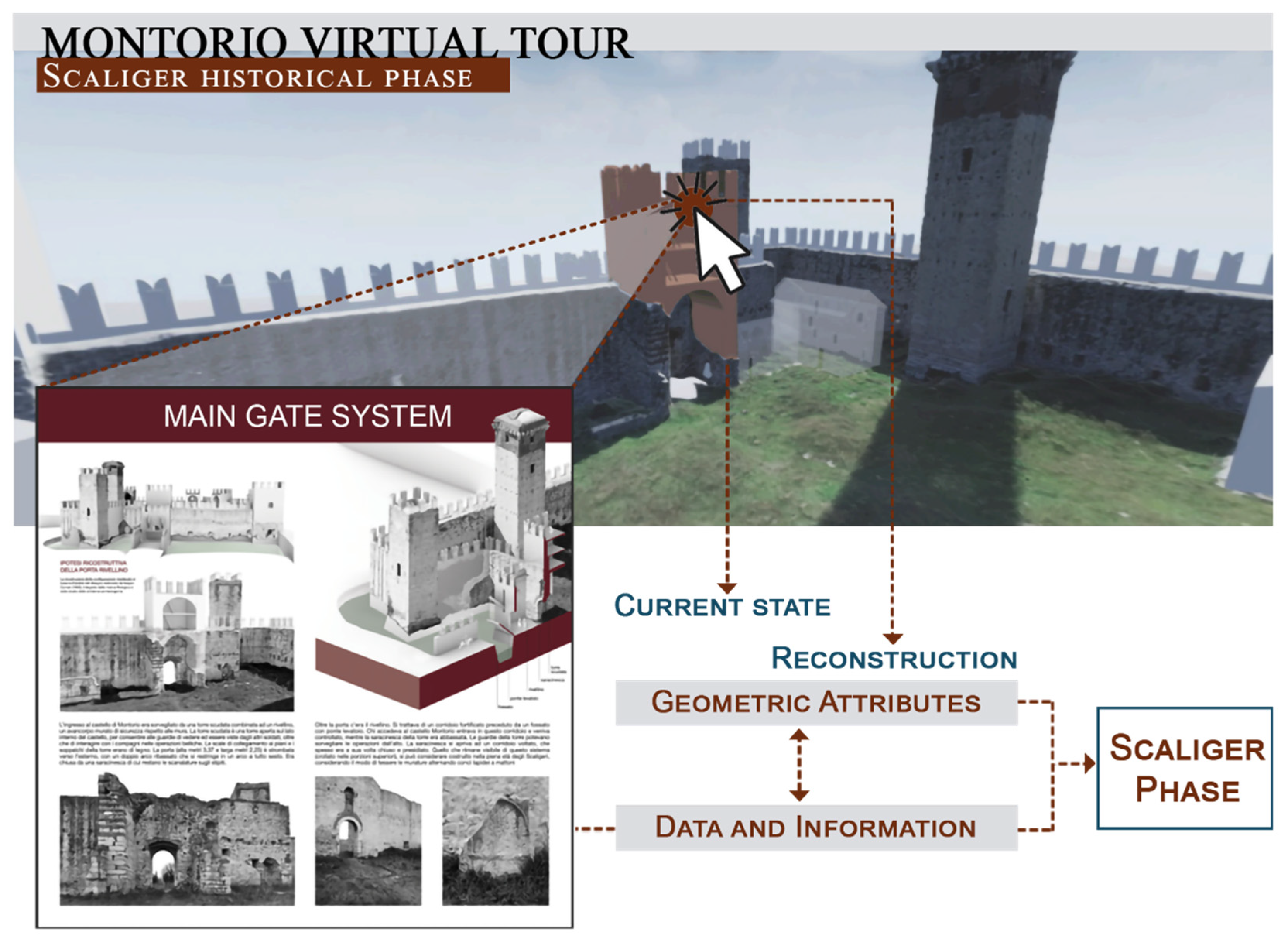
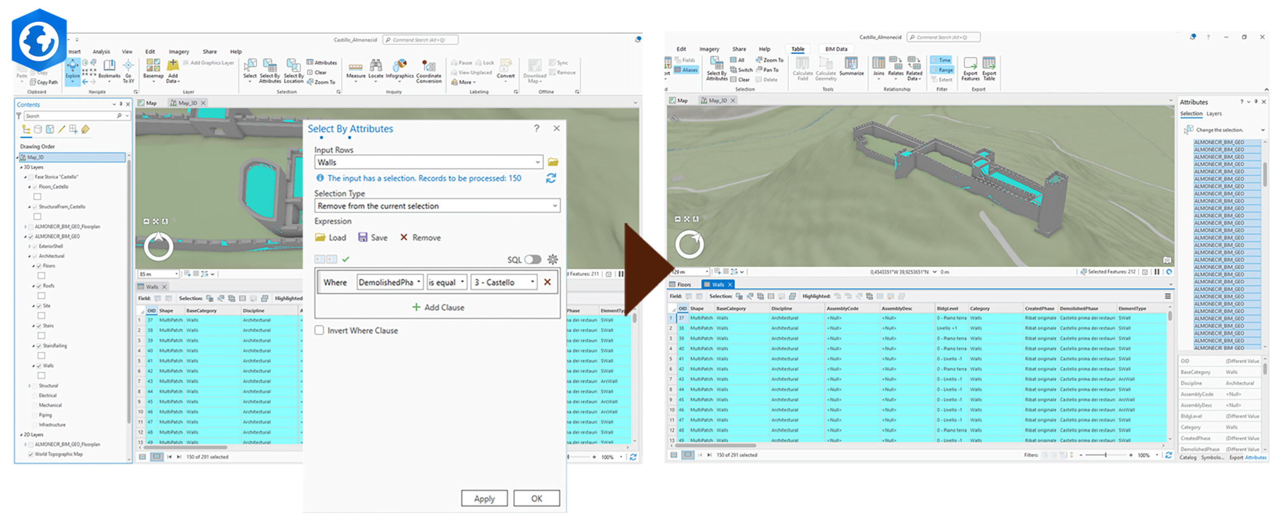
3.1. An Interrogable Platform for Online Information Retrieval
3.2. A Territorial-Scale Information Platform Integrating BIM-GIS Systems
4. Discussion
5. Conclusions
Author Contributions
Funding
Data Availability Statement
Acknowledgments
Conflicts of Interest
References
- De Luca, L.; Veron, P.; Florenzano, M. A semantic-based platform for the digital analysis of architectural heritage. Comput. Graph. 2011, 35, 227–241. [Google Scholar] [CrossRef]
- Stefani, C.; De Luca, L.; Pizzo, A. Time indeterminacy and spatio-temporal building transformations: An approach for architectural heritage understanding. Int. J. Interact. Des. Manuf. (IJIDeM) 2010, 4, 61–74. [Google Scholar] [CrossRef]
- Salonia, P.; Negri, A. ARKIS: An information system as a tool for analysis and representation of heterogeneous data on an architectural scale. In Proceedings of the WSCG 2000, Plzen, Czech Republic, 7–11 February 2000. [Google Scholar]
- De Luca, L.; Lo Buglio, D. Geometry vs Semantics: Open Issues on 3D Reconstruction of Architectural Elements. In 3D Research Challenges in Cultural Heritage; Lecture Notes in Computer Science; Ioannides, M., Quak, E., Eds.; Springer: Berlin/Heidelberg, Germany, 2014; Volume 8355. [Google Scholar]
- Beraldin, J.-A. Integration of laser scanning and close-range photogrammetry-the last decade and beyond. In Proceedings of the XXth ISPRS Congress, Commission VII, Istanbul, Turkey, 12–23 July 2004; pp. 972–983. [Google Scholar]
- Kadobayashi, R.; Kochi, N.; Otani, H.; Furukawa, R. Comparison and evaluation of laser scanning and photogrammetry and their combined use for digital recording of cultural heritage. Int. Arch. Photogr. Remote Sens. Spat. Inf. Sci. 2004, 35, 401–406. [Google Scholar]
- Mulahusić, A.; Tuno, N.; Gajski, D.; Topoljak, J. Comparison and analysis of results of 3D modelling of complex cultural and historical objects using different types of terrestrial laser scanner. Surv. Rev. 2018, 52, 107–114. [Google Scholar] [CrossRef]
- Grussenmeyer, P.; Alby, E.; Landes, T.; Koehl, M.; Guillemin, S.; Hullo, J.-F.; Assali, P.; Smigiel, E. Recording approach of heritage sites based on merging point clouds from high resolution photogrammetry and terrestrial laser scanning. ISPRS Int. Arch. Photogramm. Remote Sens. Spat. Inf. Sci. 2012, 39, 553–558. [Google Scholar] [CrossRef]
- Pritchard, D.; Rigauts, T.; Ripanti, F.; Ioannides, M.; Brumana, R.; Davies, R.; Avouri, E.; Cliffen, H.; Joncic, N.; Osti, G.; et al. Study on Quality in 3D Digitisation of Tangible Cultural Heritage. In Proceedings of the Joint International Event 9th ARQUEOLÓGICA 2.0 & 3rd GEORES, Valencia, Spain, 26–28 April 2021. [Google Scholar]
- Brumana, R.; Banfi, F.; Cantini, L.; Previtali, M.; Della Torre, S. HBIM Level of Detail-Geometry-Accuracy and Survey Analysis for Architectural Preservation. In Proceedings of the ISPRS Annals of the Photogrammetry, Remote Sensing and Spatial Information Sciences, Milan, Italy, 8–10 May 2019; Volume 42. [Google Scholar]
- De Luca, L. Methods, formalisms and tools for the semantic-based surveying and representation of architectural heritage. Appl. Geomat. 2011, 6, 115–139. [Google Scholar] [CrossRef]
- Montes Serrano, C. El dibujo como arte de la memoria: Breves notas sobre los fundamentos de la Representación. Tribelon J. Draw. Represent. Archit. Landsc. Environ. 2024, 1, 50–59. [Google Scholar] [CrossRef]
- Cortés Meseguer, L.; Picchio, F.; Porcheddu, G. Disegnare un sistema informativo 3D per la promozione della rotta culturale di Jaime I a Valencia. In Transizioni = Transitions; FrancoAngeli: Milano, Italia, 2023; pp. 1832–1857. [Google Scholar]
- Bolognesi, C.; Garagnani, S. From a Point Cloud Survey to a mass 3D modelling: Renaissande HBIM in Poggio a Caiano. Int. Arch. Photogramm. Remote Sens. Spat. Inf. Sci. 2018, 42, 117–123. [Google Scholar] [CrossRef]
- Havemann, S.; Settgast, V.; Berndt, R.; Eide, Ø.; Fellner, D. The Arrigo showcase reloaded—Towards a sustainable link between 3D and semantics. In Proceedings of the VAST 2008, Columbus, OH, USA, 19–24 October 2008; pp. 125–132. [Google Scholar]
- Acierno, M.; Cursi, S.; Simeone, D.; Fiorani, D. Architectural heritage knowledge modelling: An ontology-based framework for conservation process. J. Cult. Herit. 2017, 24, 124–133. [Google Scholar] [CrossRef]
- Dudek, I.; Blaise, J.-Y.; Beninstant, P. Exploiting the architectural heritage’s documentation: A case study on data analysis and visualisation. In Proceedings of the I-KNOW ‘03, Graz, Austria, 2–4 July 2003. [Google Scholar]
- Barazzetti, L.; Banfi, F.; Brumana, R.; Oreni, D.; Previtali, M.; Roncoroni, F. HBIM and augmented information: Towards a wider user community of image and range-based reconstructions. In Proceedings of the 25th International CIPA Symposium 2015 on the International Archives of the Photogrammetry, Remote Sensing and Spatial Information Sciences, Taipei, Taiwan, 31 August–4 September 2015; Volume 40, pp. 35–42. [Google Scholar]
- Apollonio, F.I.; Gaiani, M.; Sun, Z. 3D Modeling and Data Enrichment in Digital Reconstruction of Architectural Heritage. Int. Arch. Photogramm. Remote Sens. Spat. Inf. Sci. 2013, 40, 43–48. [Google Scholar] [CrossRef]
- Attene, M.; Robbiano, F.; Spagnuolo, M.; Falcidieno, B. Characterization of 3D shape parts for semantic annotation. Comput. Aided Des. 2009, 41, 756–763. [Google Scholar] [CrossRef]
- Quattrini, R.; Baleani, E. Theoretical background and historical analysis for 3D reconstruction model. Villa Thiene at Cicogna. J. Cult. Herit. 2015, 16, 119–125. [Google Scholar] [CrossRef]
- Pierdicca, R.; Frontoni, E.; Malinverni, E.S.; Colosi, F.; Orazi, R. Virtual reconstruction of archaeological heritage using a combination of photogrammetric techniques: Huaca Arco Iris, Chan Chan, Peru. Digit. Appl. Archaeol. Cult. Herit. 2016, 3, 80–90. [Google Scholar] [CrossRef]
- Guidi, G.; Remondino, F.; Russo, M.; Menna, F.; Rizzi, A.; Ercoli, S. A multi-resolution methodology for the 3D modelling of large and complex archaeological areas. Int. J. Architect. Comput. 2009, 7, 40–55. [Google Scholar] [CrossRef]
- Ulvi, A. Documentation, Three-Dimensional (3D) Modelling and visualization of cultural heritage by using Unmanned Aerial Vehicle (UAV) photogrammetry and terrestrial laser scanners. Int. J. Remote Sens. 2021, 42, 1994–2021. [Google Scholar] [CrossRef]
- Guidi, G.; Russo, M.; Angheleddu, D. 3D Survey and virtual reconstruction of archaeological sites. Digit. Appl. Archaeol. Cult. Herit. 2014, 1, 55–69. [Google Scholar]
- De Luca, L.; Véron, P.; Florenzano, M. A generic formalism for the semantic modelling and representation of architectural elements. Vis. Comput. 2007, 23, 181–205. [Google Scholar] [CrossRef]
- Pfarr-Harfst, M. Typical Workflows, Documentation Approaches and Principles of 3D Digital Reconstruction of Cultural Heritage. In 3D Research Challenges in Cultural Heritage II; Münster, S., Pfarr-Harfst, M., Kuroczyński, P., Ioannides, M., Eds.; Springer LNCS: Cham, Switzerland, 2016. [Google Scholar]
- De Luca, L.; Véron, P.; Thibault, G.; Florenzano, M. An iconography-based modelling approach for the spatio-temporal analysis of architectural heritage. In Proceedings of the 2010 Shape Modeling International Conference, Aix-en-Provence, France, 21–23 June 2010; IEEE: Piscataway Township, NJ, USA; pp. 78–89. [Google Scholar]
- De Luca, L.; Driscu, T.; Peyrols, E.; Labrosse, D.; Berthelot, M. A complete methodology for the virtual assembling of dismounted historic buildings. Int. J. Interact. Des. Manuf. 2014, 8, 265–276. [Google Scholar] [CrossRef]
- Parrinello, S.; Pettineo, A. Traditional Architectures Along the Cultural Route of James I of Aragon in the Province of Valencia: Leveraging Laser Scanning and BIM for Heritage Management. Mater. Res. Proc. 2024, 40, 350–357. [Google Scholar]
- Picchio, F.; Pettineo, A. Digitalizzare, ricostruire e fruire il Castello di Montorio. Un tassello nella definizione della rotta culturale dei castelli scaligeri. In Defensive Architecture of the Mediterranean; Pisa University Press: Pisa, Italy, 2023; Volome XV; pp. 1123–1130. [Google Scholar]
- Parrinello, S.; Picchio, F.; La Placa, S. The Construction of an Informative 3D Model for the Monitoring of City Heritage Risk. In Reviving Aleppo: Urban, Legal and Digital Approaches for Post-War Recovery; Springer International Publishing: Cham, Switzerland, 2024; pp. 243–274. [Google Scholar]
- Attenni, M. Informative Models for Architectural Heritage. Heritage 2019, 2, 2067–2089. [Google Scholar] [CrossRef]
- Parrinello, S.; Porcheddu, G. Documentation procedures for rescue archaeology through information systems and 3D databases. In Beyond Digital Representation: Digital Innovations in Architecture, Engineering and Construction; Giordano, A., Russo, M., Spallone, R., Eds.; Springer: Cham, Switzerland, 2024; pp. 1–12. [Google Scholar]
- De Marco, R.; Dell’Amico, A. Documentation and Digital Representation Systems from the Monument to the Territory: The H2020 PROMETHEUS project. Prosp. Mult. Stud. Ing. Archit. Arte 2023, 3, 138–155. [Google Scholar]
- Parrinello, S.; Cioli, F. Establishment of a Complex Database for the Study of Cultural Heritage Through the Reading and Analysis of the Traditional Architecture of Upper Kama. In Digital Cultural Heritage; Kremers, H., Ed.; Springer: Cham, Switzerland, 2020; pp. 55–70. [Google Scholar]
- Meyer, D.; Fraijo, E.; Lo, E.; Rissolo, D.; Kuester, F. Optimizing UAV systems for rapid survey and reconstruction of large scale cultural heritage sites. In Proceedings of the Digital Heritage, Granada, Spain, 28 September–2 October 2015. [Google Scholar]
- Dell’Amico, A. Mobile laser scanner mapping systems for the efficiency of the survey and representation processes. Int. Arch. Photogramm. Remote Sens. Spat. Inf. Sci. 2021, 46, 199–205. [Google Scholar] [CrossRef]
- Deliry, S.I.; Avdan, U. Accuracy of unmanned aerial systems photogrammetry and structure from motion in surveying and mapping: A review. J. Indian Soc. Remote Sens. 2021, 49, 1997–2017. [Google Scholar] [CrossRef]
- Barba, S.; Barbarella, M.; Di Benedetto, A.; Fiani, M.; Gujski, L.; Limongiello, M. Accuracy assessment of 3D photogrammetric models from an unmanned aerial vehicle. Drones 2019, 3, 79. [Google Scholar] [CrossRef]
- Di Stefano, F.; Chiappini, S.; Gorreja, A.; Balestra, M.; Pierdicca, R. Mobile 3D scan LiDAR: A literature review. Geomat. Nat. Hazards Risk 2021, 12, 2387–2429. [Google Scholar] [CrossRef]
- Parrinello, S.; Picchio, F. Integration and comparison of close-range SfM methodologies for the analysis and the development of the historical city center of Bethlehem. Int. Arch. Photogramm. Remote Sens. Spat. Inf. Sci. 2019, 42, 589–595. [Google Scholar] [CrossRef]
- Doria, E.; La Placa, S.; Picchio, F. From reality-based model to GIS platform. Multi-scalar modeling for irrigated landscape management in the Pavia plain. Int. Arch. Photogramm. Remote Sens. Spat. Inf. Sci. 2022, 48, 73–80. [Google Scholar] [CrossRef]
- Costamagna, E.; Spanò, A. Semantic Models for Architectural Heritage Documentation. In Progress in Cultural Heritage Preservation. EuroMed 2012; Lecture Notes in Computer Science; Springer: Berlin/Heidelberg, Germany, 2012; Volume 7616. [Google Scholar]
- Apollonio, F.I. Classification Schemes for Visualization of Uncertainty in Digital Hypothetical Reconstruction. In 3D Research Challenges in Cultural Heritage II: How to Manage Data and Knowledge Related to Interpretative Digital 3D Reconstructions of Cultural Heritage; Münster, S., Pfarr-Harfst, M., Kuroczyński, P., Ioannides, M., Eds.; Springer International Publishing: Cham, Switzerland, 2016; pp. 173–197. [Google Scholar]
- Buglio, D.L.; Luca, L.D. Representation of architectural artifacts definition of an approach combining the complexity of the 3D digital instance with the intelligibility of the theoretical model. Sci. Res. Inf. Technol. 2012, 2, 63–76. [Google Scholar]
- Stefani, C.; Busayarat, C.; Renaudin, N.; De Luca, L.; Véron, P.; Florenzano, M. An Image-Based approach for the Architectural Modelling of past states. Int. Arch. Photogr. Remote Sens. Spat. Inf. Sci. 2012, 38, 397–404. [Google Scholar]
- Kowalski, S.; La Placa, S.; Pettineo, A. From archives sources to virtual 3D reconstruction of military heritage—The case study of Port Battery, Gdańsk. Int. Arch. Photogramm. Remote Sens. Spat. Inf. Sci. 2023, 48, 885–893. [Google Scholar] [CrossRef]
- Pettineo, A. Videogrammetry for the virtual philological reconstruction of the Scaliger fortifications in the territory of Verona: The case study of Montorio Castle. In D-SITE Drones-Systems of Information on Cultural Heritage for a Spatial and Social Investigation; Pavia University Press: Pavia, Italia, 2022; Volume 2, pp. 104–111. [Google Scholar]
- Croce, V.; Caroti, G.; Piemonte, A.; Bevilacqua, M.G. From Survey to Semantic Representation for Cultural Heritage: The 3D Modeling of Recurring Architectural Elements. Acta IMEKO 2021, 10, 98. [Google Scholar] [CrossRef]
- Di Stefano, F.; Gorreja, A.; Malinverni, E.S.; Mariotti, C. Knowledge modelling for heritage conservation process: From survey to HBIM implementation. Int. Arch. Photogramm. Remote Sens. Spat. Inf. Sci. 2020, 44, 19–26. [Google Scholar] [CrossRef]
- Rocha, G.; Mateus, L.; Fernández, J.; Ferreira, V. A Scan-to-BIM Methodology Applied to Heritage Buildings. Heritage 2020, 3, 47–67. [Google Scholar] [CrossRef]
- Quattrini, R.; Malinverni, E.S.; Clini, P.; Nespeca, R.; Orlietti, E. From TLS to HBIM. High quality semantically-aware 3D modeling of complex architecture. Int. Arch. Photogramm. Remote Sens. Spat. Inf. Sci. 2015, 40, 367. [Google Scholar] [CrossRef]
- Parrinello, S.; Sanseverino, A.; Fu, H. HBIM Modelling for the architectural valorisation via a maintenance digital eco-system. Int. Arch. Photogramm. Remote Sens. Spat. Inf. Sci. 2023, 48, 1157–1164. [Google Scholar] [CrossRef]
- Martinelli, L.; Calcerano, F.; Gigliarelli, E. Methodology for an HBIM Workflow Focused on the Representation of Construction Systems of Built Heritage. J. Cult. Herit. 2022, 55, 277–289. [Google Scholar] [CrossRef]
- Lombardi, M.; Rizzi, D. Semantic modelling and HBIM: A new multidisciplinary workflow for archaeological heritage. Digit. Appl. Archaeol. Cult. Herit. 2024, 32, e00322. [Google Scholar] [CrossRef]
- Sampaio, A.Z.; Tomé, J.; Gomes, A.M. Heritage Building Information Modelling Implementation First Steps Applied in a Castle Building: Historic Evolution Identity, Data Collection and Stratigraphic Modelling. Heritage 2023, 6, 6472–6493. [Google Scholar] [CrossRef]
- Khalil, A.; Stravoravdis, S.; Backes, D. Categorisation of Building Data in the Digital Documentation of Heritage Buildings. Appl. Geomat. 2021, 13, 29–54. [Google Scholar] [CrossRef]
- Adami, A.; Fregonese, L.; Rosignoli, O.; Scala, B.; Taffurelli, L.; Treccani, D. Geometric survey data and historical sources interpretation for HBIM process: The case of Mantua Cathedral façade. Int. Arch. Photogramm. Remote Sens. Spat. Inf. Sci. 2019, 42, 29–35. [Google Scholar] [CrossRef]
- Foschi, R.; Fallavollita, F.; Apollonio, F.I. Quantifying Uncertainty in Hypothetical 3D Reconstruction—A User-Independent Methodology for the Calculation of Average Uncertainty. Heritage 2024, 7, 4440–4454. [Google Scholar] [CrossRef]
- Oreni, D.; Brumana, R.; Banfi, F.; Bertola, L.; Barazzetti, L.; Cuca, B.; Roncoroni, F. Beyond Crude 3D Models: From Point Clouds to Historical Building Information Modeling via NURBS. In Proceedings of the Cultural Heritage, Documentation, Preservation, and Protection 5th International Conference, EuroMed 2014, Limassol, Cyprus, 3–8 November 2014; pp. 166–175. [Google Scholar]
- Roman, O.; Avena, M.; Farella, E.M.; Remondino, F.; Spano, A. A Semi-Automated Approach to Model Architectural Elements in Scan-To-Bim Processes. In Proceedings of the International Archives of the Photogrammetry, Remote Sensing and Spatial Information Sciences, Florence, Italy, 25–30 June 2023. [Google Scholar]
- Picchio, F.; Meseguer, L.C.; González, M.C.L.; Valldecabres, J.G.; Pettineo, A.; dell′Amico, A.; Fu, H.; Galasso, F. Repositorio 3D para la puesta en valor de la Ruta Cultural de Jaime I en Valencia. In Pensar Dibujando; APEGA, edUPV (Universitat Politècnica de València): Valencia, Spain, 2024; pp. 299–309. [Google Scholar]
- Parrinello, S.; Picchio, F. Digital Strategies to Enhance Cultural Heritage Routes: From Integrated Survey to Digital Twins of Different European Architectural Scenarios. Drones 2023, 7, 576. [Google Scholar] [CrossRef]
- Yang, X.; Grussenmeyer, P.; Koehl, M.; Macher, H.; Murtiyoso, A.; Landes, T. Review of built heritage modelling: Integration of HBIM and other information techniques. J. Cult. Herit. 2020, 46, 350–360. [Google Scholar] [CrossRef]
- Jordàn Palomar, I.; Garcìa Valldecabres, J.; Tzortzopoulos, P.; Pellicer, E. An online platform to unify and synchronise heritage architecture information. Autom. Constr. 2020, 110, 103008. [Google Scholar] [CrossRef]
- Shirowzhan, S.; Sepasgozar, S.M.E.; Edwards, D.J.; Li, H.; Wang, C. BIM compatibility and its differentiation with interoperability challenges as an innovation factor. Autom. Constr. 2020, 112, 103086. [Google Scholar] [CrossRef]
- Matrone, F.; Colucci, E.; De Ruvo, V.; Lingua, A.; Spanò, A. HBIM in a semantic 3D GIS database. ISPRS Int. Arch. Photogramm. Remote Sens. Spat. Inf. Sci. 2019, 42, 857–865. [Google Scholar] [CrossRef]
- Galeazzo, L. Analysing Urban Dynamics in Historic Settlements Using a Geo-Spatial Infrastructure. J. Art Historiogr. 2022, 27, 4202. [Google Scholar]
- Galeazzo, L.; Parrinello, S. Historical and 3D Survey Analyses for an Informative Database on the Venetian fort of Sant’Andrea. In Proceedings of the FORTMED2024—Defensive Architecture of the Mediterranean, Tirana, Albania, 18–20 April 2024; Volume 17, pp. 619–626. [Google Scholar]
- Song, Y.; Wang, X.; Tan, Y.; Wu, P.; Sutrisna, M.; Cheng, J.C.P.; Hampson, K. Trends and Opportunities of BIM-GIS Integration in the Architecture, Engineering and Construction Industry: A Review from a Spatio-Temporal Statistical Perspective. ISPRS Int. J. Geo. Inf. 2017, 6, 397. [Google Scholar] [CrossRef]
- Deng, Y.; Cheng, J.C.P.; Anumba, C. Mapping between BIM and 3D GIS in different levels of detail using schema mediation and instance comparison. Autom. Constr. 2016, 67, 1–21. [Google Scholar] [CrossRef]
- Andriasyan, M.; Moyano, J.; Nieto-Julián, J.E.; Antón, D. From Point Cloud Data to Building Information Modelling: An Automatic Parametric Workflow for Heritage. Remote Sens. 2020, 12, 1094. [Google Scholar] [CrossRef]
- De Marco, R.; Pettineo, A. The recognition of Heritage qualities from feature-based digital procedures in the analysis of historical urban contexts. Int. Arch. Photogramm. Remote Sens. Spat. Inf. Sci. 2022, 46, 175–182. [Google Scholar] [CrossRef]
- Croce, V.; Caroti, G.; Piemonte, A.; De Luca, L.; Véron, P. H-BIM and Artificial Intelligence: Classification of Architectural Heritage for Semi-Automatic Scan-to-BIM Reconstruction. Sensors 2023, 23, 2497. [Google Scholar] [CrossRef] [PubMed]
- Cotella, V.A. From 3D Point Clouds to HBIM: Application of Artificial Intelligence in Cultural Heritage. Autom. Constr. 2023, 152, 104936. [Google Scholar] [CrossRef]


Disclaimer/Publisher’s Note: The statements, opinions and data contained in all publications are solely those of the individual author(s) and contributor(s) and not of MDPI and/or the editor(s). MDPI and/or the editor(s) disclaim responsibility for any injury to people or property resulting from any ideas, methods, instructions or products referred to in the content. |
© 2025 by the authors. Licensee MDPI, Basel, Switzerland. This article is an open access article distributed under the terms and conditions of the Creative Commons Attribution (CC BY) license (https://creativecommons.org/licenses/by/4.0/).
Share and Cite
Parrinello, S.; Pettineo, A. Databases and Information Models for Semantic and Evolutionary Analysis in Fortified Cultural Heritage. Heritage 2025, 8, 29. https://doi.org/10.3390/heritage8010029
Parrinello S, Pettineo A. Databases and Information Models for Semantic and Evolutionary Analysis in Fortified Cultural Heritage. Heritage. 2025; 8(1):29. https://doi.org/10.3390/heritage8010029
Chicago/Turabian StyleParrinello, Sandro, and Alberto Pettineo. 2025. "Databases and Information Models for Semantic and Evolutionary Analysis in Fortified Cultural Heritage" Heritage 8, no. 1: 29. https://doi.org/10.3390/heritage8010029
APA StyleParrinello, S., & Pettineo, A. (2025). Databases and Information Models for Semantic and Evolutionary Analysis in Fortified Cultural Heritage. Heritage, 8(1), 29. https://doi.org/10.3390/heritage8010029