

Unraveling the Seismic Source in Archaeoseismology: A Combined Approach on Local Site Effects and Geochemical Data Integration


Abstract
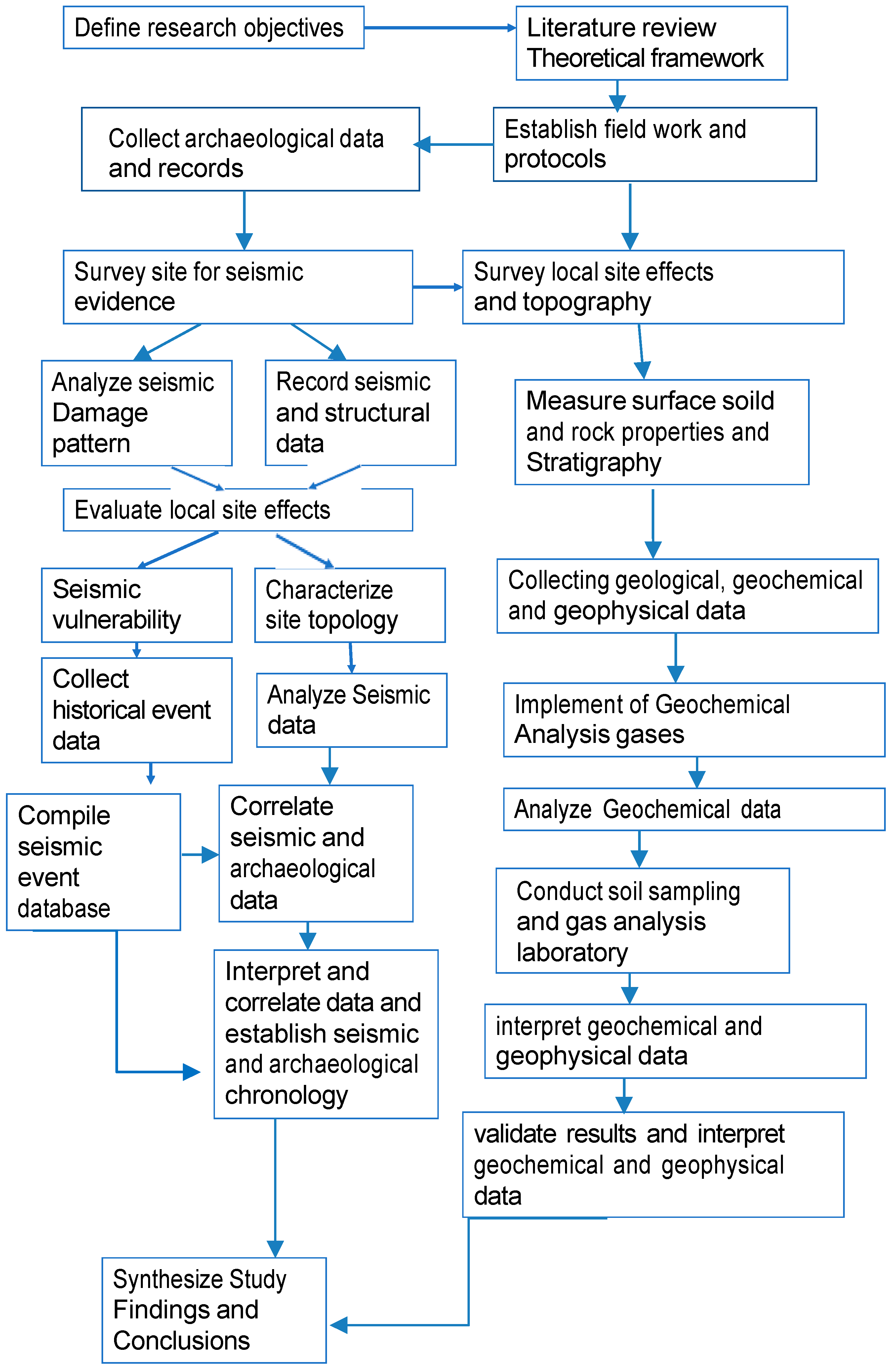
1. Introduction
2. Local Site Effects in Archaeoseismology
2.1. Introduction
2.2. Site Characterization
2.3. Geophysical Techniques
2.4. Site Amplification
- Selection of a seismic input spectrum compatible with the site’s rigid soil category.
- Definition of the seismo-stratigraphic model and determination of the physical-mechanical characteristics of the materials.
- Calculation of the seismic response at the surface.
2.5. Topographic Effects
2.6. Ground Motion
2.7. Selinunte’s Case Study of the Local Site Effect
3. Geochemistry: A Tool for Archaeoseismology
3.1. Geochemical Tecniques
3.2. Santa Venera al Pozzo Case Study
4. Discussion
5. Conclusions and Future Perspective
Author Contributions
Funding
Data Availability Statement
Acknowledgments
Conflicts of Interest
References
- Karcz, I.; Kafri, U. Evaluation of supposed archaeoseismic damage in Israel. J. Archaeol. Sci. 1978, 5, 237–253. [Google Scholar] [CrossRef]
- Rapp, G. Assessing archaeological evidence for seismic catastrophes. Geoarchaeology 1986, 1, 365–379. [Google Scholar] [CrossRef]
- Nikonov, A.A. Reconstruction of the main parameters of old large earthquakes in Soviet Central Asia using the palaeoseismological method. Tectonophysics 1988, 147, 297–312. [Google Scholar] [CrossRef]
- Stiros, S.C. Archaeology—A tool to study active tectonics. EOS 1988, 69, 1633–1639. [Google Scholar] [CrossRef]
- Guidoboni, E. (Ed.) I Terremoti Prima del Mille in Italia e Nell’area Mediterranea; Storia: Archeologia, Sismologia; ING-SGA: Bologna, Italy, 1989; p. 765. [Google Scholar]
- Rucker, J.D.; Niemi, T.N. Historical earthquake catalogues and archaeological data: Achieving synthesis without circular reasoning. In Ancient Earthquakes; Sintubin, M., Stewart, I.S., Niemi, T.N., Altunel, E., Eds.; Geological Society of America Special Paper; Geological Society of America: Boulder, CO, USA, 2011; Volume 471, pp. 97–106. [Google Scholar]
- Stiros, S.C. Identification of earthquakes from archaeological data: Methodology, criteria and limitations. In Archaeoseismology; Stiros, S., Jones, R.E., Eds.; Fitch Laboratory Occasional Paper 7; British School at Athens, Short Run Press: Oxford, UK, 1996; pp. 129–152. [Google Scholar]
- Galadini, F.; Hinzen, K.G.; Stiros, S. Archaeoseismology: Methodological issues and procedure. J. Seismol. 2006, 10, 395–414. [Google Scholar] [CrossRef]
- Marco, S. Recognition of earthquake-related damage in archaeological sites: Examples from the Dead Sea fault zone. Tectonophysics 2008, 453, 148–156. [Google Scholar] [CrossRef]
- Rodríguez-Pascua, M.A.; Pérez-López, R.; Giner-Robles, J.L.; Silva, P.G.; Garduño-Monroy, V.H.; Reicherter, K. A comprehensive classification of earthquake archaeological effects (EAE) in archaeoseismology: Application to ancient remains of Roman and Mesoamerican cultures. Quat. Int. 2011, 242, 20–30. [Google Scholar] [CrossRef]
- Hinzen, K.G.; Fleischer, C.; Reamer, S.K.; Schreiber, S.; Schütte, S.; Yeril, B. Quantitative methods in archaeoseismology. Quat. Int. 2011, 242, 31–41. [Google Scholar] [CrossRef]
- Ambraseys, N.N. Archaeoseismology and neocatastrophism. Seismol. Res. Lett. 2005, 76, 560–564. [Google Scholar] [CrossRef]
- Sintubin, M. Archaeoseismology: Past, present and future. Quat. Int. 2011, 242, 4–10. [Google Scholar] [CrossRef]
- Guidoboni, E. Historical seismology: The Long Memory of the Inhabited World. In International Handbook of Earthquake and Engineering Seismology; Lee, W., Kanamori, H., Jennings, P.C., Klissinger, C., Eds.; International Geophysics Series 81; Academic Press: Amsterdam, The Netherlands, 2002; pp. 775–790. [Google Scholar]
- Hinojosa-Prieto, H.R. The Importance of Assessing the Geological Site Effects of Ancient Earthquakes from the Archaeoseismological Point of View. ENG 2023, 4, 719–737. [Google Scholar] [CrossRef]
- Hinojosa-Prieto, H.R. Estimation of the moment magnitude and local site effects of a postulated Late Bronze Age earthquake: Mycenaean citadels of Tiryns and Midea, Greece. Ann. Geophys. 2020, 63, SE331. [Google Scholar] [CrossRef]
- Boschi, E.; Caserta, A.; Conti, C.; Di Bona, M.; Funiciello, R.; Malagnini, L.; Marra, F.; Martines, G.; Rovelli, A.; Salvi, S. Resonance of subsurface sediments: An unforeseen complication for designers of Roman Columns . Bull. Seismol. Soc. Am. 1995, 85, 320–324. [Google Scholar]
- Ganalopoulos, A. The seismic risk at Athens. Prakt. Akad. Athin. 1956, 31, 462–472. [Google Scholar]
- Stiros, S.C. Archaeological evidence of antiseismic constructions in antiquity. Ann. Geofis. 1995, 35, 725–736. [Google Scholar]
- Bottari, C. Ancient constructions as markers of tectonic deformation and of strong seismic motions. Pure Appl. Geophys. 2005, 162, 761–765. [Google Scholar] [CrossRef]
- Bottari, C.; Bottari, A.; Carveni, P.; Saccà, C.; Spigo, U.; Teramo, A. Evidence of seismic deformation of the paved floor of the decumanus at Tindari (NE, Sicily). Geophys. J. Int. 2008, 174, 213–222. [Google Scholar] [CrossRef]
- Bottari, C.; Albano, M.; Capizzi, P.; D’Alessandro, A.; Doumaz, F.; Martorana, R.; Moro, M.; Saroli, M. Recognition of earthquake-induced damage in the Abakainon necropolis (NE Sicily): Results from geomorphological, geophysical and numerical analyses. Pure Appl. Geophys. 2018, 175, 133–148. [Google Scholar] [CrossRef]
- Schwellenbach, I.; Hinzen, K.G.; Petersen, G.; Bottari, C. Combined Use of Refraction Seismic, MASW and Ambient Noise Array Measurements to Determine the Near Surface Velocity Structure in the Archaeological Park of Selinunte, SW Sicily. J. Seism. 2020, 24, 753–776. [Google Scholar] [CrossRef]
- Bottari, C.; Giammanco, S.; Cavallaro, D.; Sortino, F.; Scudero, S.; Amari, S.; Bonfanti, P.; Daolio, M.; Groppelli, G. How to reveal “forgotten” historical earthquakes applying multidisciplinary methods in archaeological sites: The case of 251 AD Mt. Etna earthquake (Eastern Sicily, Italy). Tectonophysics 2020, 790, 228544. [Google Scholar] [CrossRef]
- Sortino, F.; Giammanco, S.; Bonfanti, P.; Bottari, C. Stress-induced changes in hydrothermal gas discharges along active faults near Mt. Etna volcano (Sicily, Italy). Tectonophysics 2022, 883, 229338. [Google Scholar] [CrossRef]
- Hulot, J.; Fougères, G.; Sélinonte. La Ville, L’acropole et Les Temples. Librairie generale de l’architecture et das arts decoratifs: Paris, France, 1910. [Google Scholar]
- Bottari, C. Unknown Earthquakes in Sicily and Calabria before AD 1000. Ph.D Thesis, University of Messina, Messina, Italy, 2003. [Google Scholar]
- Hinzen, K.G.; Hinojosa-Prieto, H.R.; Kalytta, T. Site Effects in Archaeoseismic Studies at Mycenaean Tiryns and Midea. Seismol. Res. Lett. 2016, 87, 1060–1074. [Google Scholar] [CrossRef]
- Cornou, C.; Bard, P.Y. Site-to-bedrock over 1D transfer function ratio: An indicator of the proportion of edge-generated surface waves? Geophys. Res. Lett. 2003, 30, 1453. [Google Scholar] [CrossRef]
- Meng, J. Earthquake ground motion simulation with frequency-dependent soil properties. Soil Dyn. Earthq. Eng. 2007, 27, 234–241. [Google Scholar] [CrossRef]
- Hinzen, K.G.; Maran, J.; Hinojosa-Prieto, H.; Damm-Meinhardt, U.; Reamer, S.K.; Tzislakis, J.; Kemna, K.; Schweppe, G.; Fleischer, C.; Demakopoulou, K. Reassessing the Mycenaean Earthquake Hypothesis: Results of the HERACLES Project from Tiryns and Midea, Greece Reassessing the Mycenaean Earthquake Hypothesis. Bull. Seismol. Soc. Am. 2018, 108, 1046–1070. [Google Scholar] [CrossRef]
- Bensalem, R.; Chatelain, J.L.; Mechane, D.; Oubaiche, E.H.; Hellel, M.; Guiller, B.; Djeddi, M.; Djadia, L. Ambient vibration techniques applied to explain heavy damages caused in Corso (Algeria) by the 2003 Boumerdes earthquake: Understanding seismic amplification due to gentle slopes. Seismol. Res. Lett. 2010, 81, 928–940. [Google Scholar] [CrossRef]
- Hinzen, K.G. The use of engineering seismological models to interpret archaeoseismological findings in Tolbiacum, Germany: A case study. Bull. Seismol. Soc. Am. 2005, 95, 521–539. [Google Scholar] [CrossRef]
- Berilgen, M.M. Evaluation of local site effects on earthquake damages of Fatih mosque. Eng. Geol. 2007, 91, 240–253. [Google Scholar] [CrossRef]
- Karastathis, V.K.; Papadopoulos, G.A.; Novikova, T.; Roumelioti, Z.; Karmis, P.; Tsombos, P. Prediction and evaluation of nonlinear site response with potentially liquefiable layers in the area of Nafplion (Peloponnesus, Greece) for a repeat of historical earthquakes. Nat. Hazards Earth Syst. Sci. 2010, 10, 2281–2304. [Google Scholar] [CrossRef]
- Şafak, E. Local site effects and dynamic soil behavior. Soil Dyn. Earthq. Eng. 2001, 21, 453–458. [Google Scholar] [CrossRef]
- Azzaro, R.; D’Amico, S.; Mostaccio, A.; Scarfì, L.; Tuvè, T. Terremoti con effetti macrosismici in Sicilia Orientale nel periodo gennaio 2002–dicembre 2005. Quad. Geofis. 2006, 41, 1–62. [Google Scholar]
- Foti, S.; Parolai, S.; Albarello, D.; Picozzi, M. Application of surface wave methods for seismic site characterization. Surv. Geophys. 2011, 32, 777–825. [Google Scholar] [CrossRef]
- Panzera, F.; Lombardo, G.; D’Amico, S.; Galea, P. Speedy techniques to evaluate seismic site effects in particular geomorphologic conditions: Faults, cavities, landslides and topographic irregularities. In Engineering Seismology, Geotechnical and Structural Earthquake Engineering; D’Amico, S., Ed.; IntechOpen: London, UK, 2013. [Google Scholar]
- Rodriguez-Marek, A.; Bray, J.D.; Abrahamson, N.A. An empirical geotechnical seismic site response procedure. Earthq. Spectra 2001, 17, 65–87. [Google Scholar] [CrossRef]
- Akkaya, I.; Özvan, A. Site characterization in the Van settlement (Eastern Turkey) using surface waves and HVSR microtremor methods. J. Appl. Geophys. 2019, 160, 157–170. [Google Scholar] [CrossRef]
- Imposa, S.; Motta, E.; Capilleri, P.; Imposa, G. HVSR and MASW seismic survey for characterizing the local seismic response: A case study in Catania area (Italy). In Proceedings of the 1st IMEKO TC-4 International Workshop on Metrology for Geotechnics, Benevento, Italy, 17–18 March 2016. [Google Scholar]
- Capizzi, P.; Martorana, R. Geophysical Subsoil Characterization and Modeling Using Cluster Analysis for Seismic Microzonation Purposes. Geosciences 2023, 13, 246. [Google Scholar] [CrossRef]
- Pamuk, E.; Özdağ, Ö.C.; Tunçel, A.; Özyalın, Ş.; Akgün, M. Local site effects evaluation for Aliağa/İzmir using HVSR (Nakamura technique) and MASW methods. Nat. Hazards 2018, 90, 887–899. [Google Scholar] [CrossRef]
- Mahajan, A.K.; Mundepi, A.K.; Chauhan, N.; Jasrotia, A.S.; Rai, N.; Gachhayat, T.K. Active seismic and passive microtremor HVSR for assessing site effects in Jammu city, NW Himalaya, India—A case study. J. Appl. Geophys. 2012, 77, 51–62. [Google Scholar] [CrossRef]
- Mohamed, E.K.; Shokry, M.M.F.; Hassoup, A.; Helal, A.M.A. Evaluation of local site effect in the western side of the Suez Canal area by applying H/V and MASW techniques. J. Afr. Earth. Sci. 2016, 123, 403–419. [Google Scholar] [CrossRef]
- Nakamura, Y. A Method for Dynamic Characteristics Estimation of Subsurface Using Microtremor on the Ground Surface; Quarterly Report; Railway Technical Research Institute: Tokyo, Japan, 1989; Volume 30, Available online: https://www.rtri.or.jp/eng/ (accessed on 10 May 2023).
- Lermo, J.; Chavez-Garcia, F.J. Site effect evaluation using spectral ratios with only one station. Bull. Seismol. Soc. Am. 1993, 83, 1574–1594. [Google Scholar] [CrossRef]
- Mucciarelli, M. Reliability and Applicability of Nakamura’s Technique using Microtremors: An Experimental Approach. J. Earthq. Eng. 1998, 4, 625–638. [Google Scholar] [CrossRef]
- Fah, D.; Kind, F.; Giardini, D. A theoretical investigation of average H/V ratios. Geophys. J. Int. 2001, 145, 535–549. [Google Scholar] [CrossRef]
- Bonnefoy-Claudet, S.; Cotton, F.; Bard, P.Y. The nature of noise wavefield and its applications for site effects studies: A literature review. Earth-Sci. Rev. 2006, 79, 205–227. [Google Scholar] [CrossRef]
- Park, C.; Miller, D.; Xia, J. Multichannel analysis of surface waves (MASW). Geophysics 1999, 64, 3. [Google Scholar] [CrossRef]
- Martorana, R.; Capizzi, P.; Avellone, G.; D’Alessandro, A.; Siragusa, R.; Luzio, D. Assessment of a geological model by surface wave analyses. J. Geophys. Eng. 2017, 14, 159–172. [Google Scholar] [CrossRef]
- Martorana, R.; Capizzi, P.; D’Alessandro, A.; Luzio, D.; Di Stefano, P.; Renda, P.; Zarcone, G. Contribution of HVSR measures for seismic microzonation studies. Ann. Geophys. 2018, 61, SE225. [Google Scholar] [CrossRef]
- Stewart, J.P.; Afshari, K.; Hashash, Y.M.A. Guidelines for Performing Hazard-Consistent One-Dimensional Ground Response Analysis for Ground Motion Prediction; PEER Report No 2014/16; Pacific Earthquake Engineering Research Center, University of California: Berkeley, CA, USA, 2014. [Google Scholar]
- Stewart, J.P.; Afshari, K.; Goulet, C. Non-ergodic site response in seismic hazard analysis. Earthq. Spectra 2017, 33, 1385–1414. [Google Scholar] [CrossRef]
- Panzera, F.; D’Amico, S.; Lotteri, A.; Galea, P.; Lombardo, G. Seismic site response of unstable steep slope using noise measurements: The case study of Xemxija Bay area, Malta. Nat. Hazards Earth Syst. Sci. 2012, 12, 3421–3431. [Google Scholar] [CrossRef]
- Wald, D.J.; Allen, T.I. Topographic slope as a proxy for seismic site conditions and amplification. Bull. Seismol. Soc. Am. 2007, 97, 1379–1395. [Google Scholar] [CrossRef]
- Hassan, H.M.; Fosan, M.; Sayed, M.A.; Romanelli, F.; ElGabry, M.N.; Vaccari, F.; Hamed, A. Site specific ground motion modeling for a Historical Cairo site as s step towards computation of seismic input at cultural heritage sites. Eng. Geol. 2020, 268, 105524. [Google Scholar] [CrossRef]
- Aki, K. Local site effects on weak and strong ground motion. Tectonophysics 1993, 218, 93–111. [Google Scholar] [CrossRef]
- Boore, D.M. Can site response be predicted? J. Earthq. Eng. 2004, 8, 1–41. [Google Scholar] [CrossRef]
- Guidoboni, E.; Muggia, A.; Marconi, C.; Boschi, E. A case study in archaeoseismology. The collapses of the Selinunte temples (southwestern Sicily): Two earthquakes identified. Bull. Seismol. Soc. Am. 2002, 92, 2961–2982. [Google Scholar] [CrossRef]
- Bottari, C.; Stiros, S.C.; Teramo, A. Archaeological evidence for destructive earthquakes in Sicily between 400 BC and AD 600. Geoarchaeology 2009, 24, 147–175. [Google Scholar] [CrossRef]
- Rollinson, H.; Pease, V. Using Geochemical Data to Understand Geological Process; Cambridge University Press: Cambridge, UK, 2021. [Google Scholar]
- Cohen, D.R.; Bowell, R.J. Exploration Geochemistry. In Treatise on Geochemistry, 2nd ed.; Scott, S.D., Ed.; Elsevier: Oxford, UK, 2014; Volume 13, pp. 624–649. [Google Scholar]
- Martinelli, G.; Ciolini, R.; Facca, G.; Fazio, F.; Cherardu, F.; Heinicke, J.; Pierotti, L. Tectonic-Related Geochemical and Hydrological Anomalies in Italy during the Last Fifty Years. Minerals 2021, 11, 11107. [Google Scholar] [CrossRef]
- Oppenheimer, C. Volcanic Degassing, in Treatise on Geochemistry; Pergamon: Oxford, UK, 2003; pp. 123–166. [Google Scholar] [CrossRef]
- Ishikawa, T.; Hirono, T.; Matsuta, N.; Kawamoto, K.; Fujimoto, K.; Kameda, J.; Nishio, Y.; Maekawa, Y.; Honda, G. Geochemical and mineralogical characteristics of fault gouge in the Median Tectonic Line, Japan: Evidence for earthquake slip. Earth Planet Sp. 2014, 66, 1–20. [Google Scholar] [CrossRef]
- Akanda, W.G. A review of experimental procedures of gas chromatography-mass spectrometry (gc-ms) and possible sources of analytical errors. Earth Sci. 2012, 1, 1–9. [Google Scholar] [CrossRef][Green Version]
- Branciforti, M.G. L’area Archeologica di Santa Venera al Pozzo-Acium; Antiquarium: Palermo, Italy, 2006. [Google Scholar]
- Bottari, C.; Capizzi, P.; Martorana, R.; Scudero, S.; Capizzi, P.; Cavallaro, D.; Pisciotta, A.; d’Alessandro, A.; Coltelli, M.; Lodato, L. Coseismic damage at an archaeological site in Sicily, Italy: Evidence of Roman age earthquake surface faulting. Surv. Geophys. 2018, 39, 1263–1284. [Google Scholar] [CrossRef]
- Ferrara, V. Le acque termominerali di S. Venera al pozzo, studi e indagini idrogeologiche. Mem. Rend. Acc. Degli Zelanti E Dei Dafnici 2010, IX, 25–41. [Google Scholar]
- Grassa, F.; Capasso, G.; Favara, R.; Inguaggiato, S. Chemical and isotopic composition of waters and dissolved gases in some thermal springs of sicily and adjacent Volcanic Islands, Italy. Pageoph 2006, 163, 781–807. [Google Scholar] [CrossRef]
- Parello, F.; D’Alessandro, W.; Aiuppa, A.; Federico, C. Cartografia Geochimica Degli Acquiferi Etnei CNR; Gruppo Nazionale per la Difesa dalle Catastrofi Idrogeologiche pubblicazione n.2190; Officine Grafiche Riunite: Palermo, Italy, 2001; 102p. [Google Scholar]
- Liotta, M.; D’Alessandro, W.; Arienzo, I.; Longo, M. Tracing the circulation of groundwater in volcanic systems using the 87Sr/86Sr ratio: Application to Mt Etna. J. Volcanol. Geotherm. Res. 2017, 331, 102–107. [Google Scholar] [CrossRef]
- Chiodini, G.; D’Alessandro, W.; Parello, F. Geochemistry of gases and waters discharged by the mud volcanoes at Paternò Mt. Etna (Italy). Bull. Volcanol. 1996, 58, 51–58. [Google Scholar] [CrossRef]
- Dongarra, G.; Hauser, S. Isotopic composition of dissolved sulphate and hydrogen sulphide from some thermal springs of Sicily. Geothermics 1982, 11, 193–200. [Google Scholar] [CrossRef]
- Bernard, B.; Brooks, J.M.; Sackett, W.M. A geochemical model for characterization of hydrocarbon gas sources in marine sediments. In Proceedings of the Offshore Technology Conference, Houston, TX, USA, 2–5 May 1977; pp. 435–438. [Google Scholar]
- Alaimo, R.; Carapezza, M.; Dongarra, G.; Hauser, S. Geochimica delle sorgenti termali siciliane. Rend. Soc. Ital. Mineral. Petrol. 1978, 34, 577–590. [Google Scholar]
- Bonforte, A.; Guglielmino, F.; Puglisi, G. Large dyke intrusion and small eruption: The December 24, 2018 Mt. Etna eruption imaged by Sentinel-1 data. Terra Nova 2019, 31, 405–412. [Google Scholar] [CrossRef]
- De Novellis, V.; Atzori, S.; De Luca, C.; Manzo, M.; Valerio, E.; Bonano, M.; Cardaci, C.; Castaldo, R.; Di Bucci, D.; Manunta, M.; et al. DInSAR analysis and analytical modeling of Mount Etna displacements: The December 2018 volcano-tectonic crisis. Geophys. Res. Lett. 2019, 46, 5817–5827. [Google Scholar] [CrossRef]
- Calvari, S.; Bilotta, G.; Bonaccorso, A.; Caltabiano, T.; Cappello, A.; Corradino, C.; Del Negro, C.; Ganci, G.; Neri, M.; Pecora, E.; et al. The VEI 2 Christmas 2018 Etna eruption: A small but intense eruptive event or the starting phase of a larger one? Remote Sens. 2020, 12, 905. [Google Scholar] [CrossRef]


Disclaimer/Publisher’s Note: The statements, opinions and data contained in all publications are solely those of the individual author(s) and contributor(s) and not of MDPI and/or the editor(s). MDPI and/or the editor(s) disclaim responsibility for any injury to people or property resulting from any ideas, methods, instructions or products referred to in the content. |
© 2024 by the authors. Licensee MDPI, Basel, Switzerland. This article is an open access article distributed under the terms and conditions of the Creative Commons Attribution (CC BY) license (https://creativecommons.org/licenses/by/4.0/).
Share and Cite
Bottari, C.; Capizzi, P.; Sortino, F. Unraveling the Seismic Source in Archaeoseismology: A Combined Approach on Local Site Effects and Geochemical Data Integration. Heritage 2024, 7, 427-447. https://doi.org/10.3390/heritage7010021
Bottari C, Capizzi P, Sortino F. Unraveling the Seismic Source in Archaeoseismology: A Combined Approach on Local Site Effects and Geochemical Data Integration. Heritage. 2024; 7(1):427-447. https://doi.org/10.3390/heritage7010021
Chicago/Turabian StyleBottari, Carla, Patrizia Capizzi, and Francesco Sortino. 2024. "Unraveling the Seismic Source in Archaeoseismology: A Combined Approach on Local Site Effects and Geochemical Data Integration" Heritage 7, no. 1: 427-447. https://doi.org/10.3390/heritage7010021
APA StyleBottari, C., Capizzi, P., & Sortino, F. (2024). Unraveling the Seismic Source in Archaeoseismology: A Combined Approach on Local Site Effects and Geochemical Data Integration. Heritage, 7(1), 427-447. https://doi.org/10.3390/heritage7010021