
Ancient Deep Sea Bottom in Modern Mountains: New Aspects of Geoheritage from Guzeripl in Southwestern Russia


Abstract
1. Introduction
2. Study Area
3. Materials and Methods

| ID (as on Figure 1B) | Location | Geological Features | Geosite (According to [15]) | Image | ||
|---|---|---|---|---|---|---|
| Affinity to Geosite | Rank of Geosite | Part of Geosite | ||||
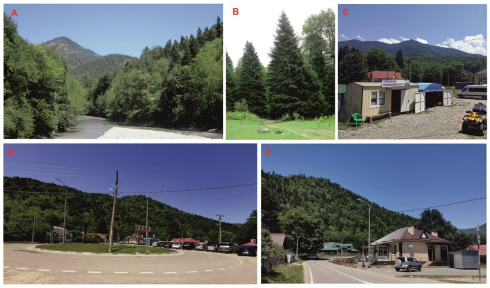
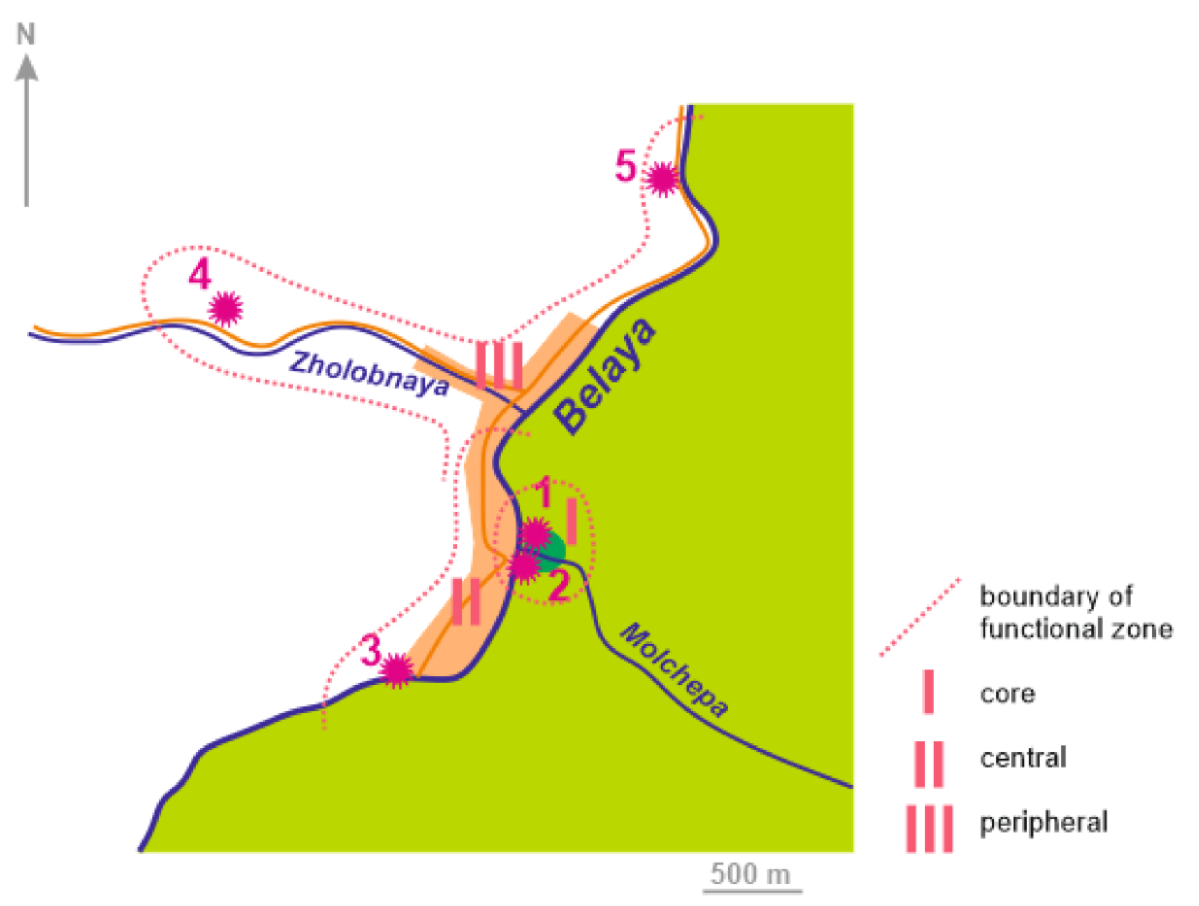
| 1 | Near the mouth of Molchepa River | Lower-Middle Jurassic shales and siltstones, trace fossils, oxygen depletion in palaeosea, tectonic distortion | Molchepa section (this geosite is fully represented in the study area) | Regional | Northern edge, principal fragment | Figure 4A,B |
| 2 | Beach of Belaya River near entrance to nature reserve | Lower-Middle Jurassic shales and siltstones, oxygen depletion in palaeosea, tectonic distortion | Central part, supplementary locality | Figure 4C | ||
| 3 | Left bank of Belaya River at town’s edge | Lower-Middle Jurassic shales, siltstones, and sandstones, oxygen depletion in palaeosea, trace fossils, tectonic distortion | Southern edge, important fragment | Figure 4D | ||
| 4 | Cutting of paved road to Partisan Glade | Lower-Middle Jurassic shales and sandstones, oxygen depletion in palaeosea, tectonic distortion | Khamyshki section (the only southern fragments of this geosite are represented in the study area) | National | Southwestern edge, supplementary locality | Figure 4E |
| 5 | Cutting of road to Maykop, Belaya River gorge | Lower-Middle Permian red molassic rocks, Lower-Middle Jurassic shales and sandstones, oxygen depletion in palaeosea, tectonic distortion, major fault | Southern part, important fragment | Figure 4F,G | ||

4. Results
5. Discussion and Conclusions
Author Contributions
Funding
Institutional Review Board Statement
Informed Consent Statement
Data Availability Statement
Acknowledgments
Conflicts of Interest
References
- Dowling, R.; Newsome, D. (Eds.) Handbook of Geotourism; Edward Elgar: Cheltenham, UK, 2018. [Google Scholar]
- Prosser, C.; Murphy, M.; Larwood, J. Geological Conservation: A Guide to Good Practice; English Nature: Peterborough, UK, 2006. [Google Scholar]
- Reynard, E.; Brilha, J. (Eds.) Geoheritage: Assessment, Protection, and Management; Elsevier: Amsterdam, The Netherlands, 2018. [Google Scholar]
- Herrera-Franco, G.; Carrión-Mero, P.; Montalván-Burbano, N.; Caicedo-Potosí, J.; Berrezueta, E. Geoheritage and Geosites: A Bibliometric Analysis and Literature Review. Geosciences 2022, 12, 169. [Google Scholar] [CrossRef]
- Carrión-Mero, P.; Dueñas-Tovar, J.; Jaya-Montalvo, M.; Berrezueta, E.; Jiménez-Orellana, N. Geodiversity assessment to regional scale: Ecuador as a case study. Environ. Sci. Policy 2022, 136, 167–186. [Google Scholar] [CrossRef]
- Coratza, P.; Vandelli, V.; Ghinoi, A. Increasing Geoheritage Awareness through Non-Formal Learning. Sustainability 2023, 15, 868. [Google Scholar] [CrossRef]
- Diniz, M.T.M.; de Araújo, I.G.D. Proposal of a Quantitative Assessment Method for Viewpoint Geosites. Resources 2022, 11, 115. [Google Scholar] [CrossRef]
- El Hassi, M.F.; Muftah, A.M. An Inventory Study of the Geosites in the Area From Susa to Darnah in Al Jabal al Akhdar, Libya: A Proposed Geopark. Geoheritage 2022, 14, 122. [Google Scholar] [CrossRef]
- Guerra, V.; Lazzari, M. Geoheritage Assessment and Potential Geotouristic Enhancement in Mountain Environments: A Test-Site in the Northern Apennines (Italy). Geoheritage 2022, 14, 97. [Google Scholar] [CrossRef]
- Hernández, W.; Dóniz-Páez, J.; Pérez, N.M. Urban Geotourism in La Palma, Canary Islands, Spain. Land 2022, 11, 1337. [Google Scholar] [CrossRef]
- Kubalíková, L.; Balková, M. Two-level assessment of threats to geodiversity and geoheritage: A case study from Hády quarries (Brno, Czech Republic). Environ. Impact Assess. Rev. 2023, 99, 107024. [Google Scholar] [CrossRef]
- Matshusa, K.; Leonard, L. Proposed Governance Model for Geotourism and Geoheritage in South Africa and the Implications for Africa. Geoheritage 2023, 15, 19. [Google Scholar] [CrossRef]
- Neto, K.; Henriques, M.H. Geoconservation in Africa: State of the art and future challenges. Gondwana Res. 2022, 110, 107–113. [Google Scholar] [CrossRef]
- Zafeiropoulos, G.; Drinia, H. Comparative Analysis of Two Assessment Methods for the Geoeducational Values of Geosites. A Case Study from the Volcanic Island of Nisyros, SE Aegean Sea, Greece. Geosciences 2022, 12, 82. [Google Scholar] [CrossRef]
- Ruban, D.A.; Mikhailenko, A.V.; Yashalova, N.N. Valuable geoheritage resources: Potential versus exploitation. Resour. Policy 2022, 77, 102665. [Google Scholar] [CrossRef]
- Ruban, D.A. Jurassic trace fossil localities of Adygeya (Russia): New geoheritage under anthropogenic pressure. J. Geogr. Inst. Jovan Cvijic SASA 2019, 69, 83–89. [Google Scholar] [CrossRef]
- Bedanokov, M.K.; Chich, S.K.; Chetyz, D.Y.; Trepet, S.A.; Lebedev, S.A.; Kostianoy, A.G. Physicogeographical characteristics of the Republic of Adygea. In Handbook of Environmental Chemistry; Springer: Cham, Switzerland, 2020; Volume 106, pp. 19–55. [Google Scholar]
- Lozovoy, S.P. Lagonaki Highland; Krasnodarskoe Knizhnoe Izdatel’stvo: Krasnodar, Russia, 1984; 160p. (In Russian) [Google Scholar]
- Nazarenko, O.V.; Mikhailenko, A.V.; Smagina, T.A.; Kutilin, V.S. Natural Conditions of Mountainous Adygeya; SFU: Rostov-on-Don, Russia, 2020. (In Russian) [Google Scholar]
- Alekseeva, A.E.; Ershov, A.V.; Linev, D.N. Numerical modeling of uplift and erosion at the Western Caucasus orogen in the Neogene-Quaternary. Mosc. Univ. Geol. Bull. 2014, 69, 213–218. [Google Scholar] [CrossRef]
- Bewick, S.; Parkinson, I.J.; Harris, N.; Adamia, S.; Sadradze, N.; Allen, M.B.; Hammond, S. Quaternary Collision-Zone Magmatism of the Greater Caucasus. J. Petrol. 2022, 63, egac037. [Google Scholar] [CrossRef]
- Forte, A.M.; Gutterman, K.R.; van Soest, M.C.; Gallagher, K. Building a Young Mountain Range: Insight Into the Growth of the Greater Caucasus Mountains From Detrital Zircon (U-Th)/He Thermochronology and 10Be Erosion Rates. Tectonics 2022, 41, e2021TC006900. [Google Scholar] [CrossRef]
- Mosar, J.; Mauvilly, J.; Koiava, K.; Gamkrelidze, I.; Enna, N.; Lavrishev, V.; Kalberguenova, V. Tectonics in the Greater Caucasus (Georgia—Russia): From an intracontinental rifted basin to a doubly verging fold-and-thrust belt. Mar. Pet. Geol. 2022, 140, 105630. [Google Scholar] [CrossRef]
- Van Hinsbergen, D.J.J.; Torsvik, T.H.; Schmid, S.M.; Matenco, L.C.; Maffione, M.; Vissers, R.L.M.; Gürer, D.; Spakman, W. Orogenic architecture of the Mediterranean region and kinematic reconstruction of its tectonic evolution since the Triassic. Gondwana Res. 2020, 81, 79–229. [Google Scholar] [CrossRef]
- Adamia, S.; Alania, V.; Chabukiani, A.; Kutelia, Z.; Sadradze, N. Great Caucasus (Cavcasioni): A long-lived North-Tethyan back-arc basin. Turk. J. Earth Sci. 2011, 20, 611–628. [Google Scholar] [CrossRef]
- Gazeev, V.M.; Gurbanov, A.G.; Kondrashov, I.A. Middle-Jurassic volcanites of the Goitkhsko-Achishkinsk folded zone of the North-Western Caucasus: Geochemistry, geodynamical typification and minerageny. Geol. I Geofiz. Yuga Ross. 2021, 11, 17–32. [Google Scholar]
- Kazmin, V.G.; Tikhonova, N.F. Early Mesozoic marginal seas in Black Sea-Caucasus region: Paleotectonic reconstructions. Geotectonics 2005, 39, 349–363. [Google Scholar]
- McCann, T.; Chalot-Prat, F.; Saintot, A. The Early Mesozoic evolution of the Western Greater Caucasus (Russia): Triassic-Jurassic sedimentary and magmatic history. Geol. Soc. Spec. Publ. 2010, 340, 181–238. [Google Scholar] [CrossRef]
- Trifonov, V.G.; Sokolov, S.Y.; Sokolov, S.A.; Hessami, K. Mesozoic–Cenozoic Structure of the Black Sea–Caucasus–Caspian Region and Its Relationships with the Upper Mantle Structure. Geotectonics 2020, 54, 331–355. [Google Scholar] [CrossRef]
- Ruban, D.A. The palaeogeographic outlines of the Caucasus in the Jurassic: The Caucasian Sea and the Neotethys Ocean. Geol. Anal. Balk. Poluostrva 2006, 67, 1–11. [Google Scholar] [CrossRef]
- Ruban, D.A. Jurassic maximum flooding surfaces in the Greater Caucasus Basin (Northern Neo-Tethys). Cent. Eur. Geol. 2008, 51, 99–112. [Google Scholar] [CrossRef]
- Latysheva, I.V.; Kirmasov, A.B. Estimation of the Deformation Value in Terrigenous Rocks by the Random Cross-Section Method (Belaya River, Northern Slope of the Greater Caucasus). Mosc. Univ. Geol. Bull. 2018, 73, 229–237. [Google Scholar] [CrossRef]
- Rostovtsev, K.O.; Agaev, V.B.; Azarian, N.R.; Babaev, R.G.; Besnosov, N.V.; Hassanov, N.A.; Zesashvili, V.I.; Lomize, M.G.; Paitschadze, T.A.; Panov, D.I.; et al. Jurassic of the Caucasus; Nauka: St. Petersburg, Russia, 1992. (In Russian) [Google Scholar]
- Teodorovich, G.I.; Pokhvisneva, E.A. Lithology and Diagenesis of Jurassic Deposits of the North-Western Caucasus; Nauka: Moscow, USSR, 1964. (In Russian) [Google Scholar]
- Ruban, D.A.; Nielsen, J.K.; Mikhailenko, A.V.; Nazarenko, O.V.; Zayats, P.P. Ichnogeneric diversity in the Jurassic deposits of the Western Caucasus: A brief summary. Stratigr. Sedimentol. Oil-Gas Basins 2017, 1, 3–10. [Google Scholar]
- Akatov, V.V.; Akatova, T.V.; Chefranov, S.G.; Eskina, T.G. Impact of dominants on the species richness and compositional dissimilarity of high mountain plant communities of the western Caucasus (Caucasian state nature reserve, Russia). Nat. Conserv. Res. 2021, 6, 52–61. [Google Scholar] [CrossRef]
- Colwell, M.A.; Dubynin, A.V.; Koroliuk, A.Y.; Sobolev, N.A. Russian nature reserves and conservation of biological diversity. Nat. Areas J. 1997, 17, 56–68. [Google Scholar]
- Kovalev, V. The nature preserves of Caucasia and their contribution to biodiversity. Arch. Nat. Conserv. Landsc. Res. 2001, 40, 155–182. [Google Scholar]
- Trepet, S.A.; Eskina, T.G.; Pkhitikov, A.B.; Kudaktin, A.N.; Bibina, K.V. Modern Condition and Population Dynamics of the Brown Bear (Ursus arctos meridionalis) in the Western Caucasus. Biol. Bull. 2020, 47, 1022–1031. [Google Scholar] [CrossRef]
- Brilha, J. Inventory and Quantitative Assessment of Geosites and Geodiversity Sites: A Review. Geoheritage 2016, 8, 119–134. [Google Scholar] [CrossRef]
- Bruschi, V.M.; Cendrero, A. Geosite evaluation; can we measure intangible values? Alp. Mediterr. Quat. 2005, 18, 293–306. [Google Scholar]
- Dede, V.; Zorlu, K. Geoheritage Assessment with Entropy-Based WASPAS Approach: An Analysis on Karçal Mountains (Turkey). Geoheritage 2023, 15, 5. [Google Scholar] [CrossRef]
- Fassoulas, C.; Mouriki, D.; Dimitriou-Nikolakis, P.; Iliopoulos, G. Quantitative Assessment of Geotopes as an Effective Tool for Geoheritage Management. Geoheritage 2012, 4, 177–193. [Google Scholar] [CrossRef]
- Mucivuna, V.C.; Motta Garcia, M.D.G.; Reynard, E. Comparing quantitative methods on the evaluation of scientific value in geosites: Analysis from the Itatiaia National Park, Brazil. Geomorphology 2022, 396, 107988. [Google Scholar] [CrossRef]
- White, S.; Wakelin-King, G.A. Earth sciences comparative matrix: A comparative method for geoheritage assessment. Geogr. Res. 2014, 52, 168–181. [Google Scholar] [CrossRef]
- Carvalho, I.S.; Leonardi, G. The Invisibles of Science and the Paleontological Heritage: The Brazilian Study Case. Geoheritage 2022, 14, 107. [Google Scholar] [CrossRef]
- Kubalíková, L.; Bajer, A.; Balková, M. Brief notes on geodiversity and geoheritage perception by the lay public. Geosciences 2021, 11, 54. [Google Scholar] [CrossRef]
- Somma, R. The Inventory and Quantitative Assessment of Geodiversity as Strategic Tools for Promoting Sustainable Geoconservation and Geo-Education in the Peloritani Mountains (Italy). Educ. Sci. 2022, 12, 580. [Google Scholar] [CrossRef]
- Tessema, G.A.; van der Borg, J.; Van Rompaey, A.; Van Passel, S.; Adgo, E.; Minale, A.S.; Asrese, K.; Frankl, A.; Poesen, J. Benefit Segmentation of Tourists to Geosites and Its Implications for Sustainable Development of Geotourism in the Southern Lake Tana Region, Ethiopia. Sustainability 2022, 14, 3411. [Google Scholar] [CrossRef]
- Tormey, D. New approaches to communication and education through geoheritage. Int. J. Geoherit. Park. 2019, 7, 192–198. [Google Scholar] [CrossRef]
- Bollati, I.; Fossati, M.; Zanoletti, E.; Zucali, M.; Magagna, A.; Pelfini, M. A methodological proposal for the assessment of cliffs equipped for climbing as a component of geoheritage and tools for earth science education: The case of the Verbano-Cusio-Ossola (Western Italian Alps). J. Virtual Explor. 2016, 49, 1–23. [Google Scholar]
- Henriques, M.H.; Canales, M.L.; García-Frank, A.; Gomez-Heras, M. Accessible Geoparks in Iberia: A Challenge to Promote Geotourism and Education for Sustainable Development. Geoheritage 2019, 11, 471–484. [Google Scholar] [CrossRef]
- Kim, C.; Ma, J.; Kang, N.; Jong, H.; Paek, C.; Kim, P. Ranking Mountainous Geoheritages with the 3A Approach (Attraction, Accessibility, and Amenity). Geoheritage 2023, 15, 12. [Google Scholar] [CrossRef]
- Krawiec, A.; Wysocki, W.; Jamorska, I.; Belzyt, S. Geoturist Evaluation of Geosites in the Tuchola Forest Biosphere Reserve (N Poland). Resources 2022, 11, 13. [Google Scholar] [CrossRef]
- Mikhailenko, A.V.; Ruban, D.A.; Ermolaev, V.A. Accessibility of geoheritage sites—A methodological proposal. Heritage 2021, 4, 1080–1091. [Google Scholar] [CrossRef]
- Herrera-Franco, G.; Caicedo-Potosí, J.; Carrión-Mero, P. Geodiversity and biodiversity for conceptual synthesis. WIT Trans. Ecol. Environ. 2022, 258, 383–392. [Google Scholar]
- Penn-Clarke, C.R.; Deacon, J.; Wiltshire, N.; Browning, C.; du Plessis, R. Geoheritage in the Matjiesrivier Nature Reserve, a World Heritage Site in the Cederberg, South Africa. J. Afr. Earth Sci. 2020, 166, 103818. [Google Scholar] [CrossRef]
- Szakács, A.; Chiriță, V. Protected Natural Values of Geoheritage Interest in the Călimani National Park, Eastern Carpathians, Romania. Geoheritage 2017, 9, 421–434. [Google Scholar] [CrossRef]
- Gordon, J.E. Geoheritage, geotourism and the cultural landscape: Enhancing the visitor experience and promoting geoconservation. Geosciences 2018, 8, 136. [Google Scholar] [CrossRef]
- Pijet-Migoń, E.; Migoń, P. Geoheritage and Cultural Heritage—A Review of Recurrent and Interlinked Themes. Geosciences 2022, 12, 98. [Google Scholar] [CrossRef]
- Szepesi, J.; Ésik, Z.; Soós, I.; Nemeth, B.; Suto, L.; Novak, T.J.; Harangi, S.; Lukács, R. Identification of Geoheritage Elements in a Cultural Landscape: A Case Study from Tokaj Mts, Hungary. Geoheritage 2020, 12, 89. [Google Scholar] [CrossRef]
- Kirillova, K.; Fu, X.; Lehto, X.; Cai, L. What makes a destination beautiful? Dimensions of tourist aesthetic judgment. Tour. Manag. 2014, 42, 282–293. [Google Scholar] [CrossRef]
- Coratza, P.; Gauci, R.; Schembri, J.; Soldati, M.; Tonelli, C. Bridging Natural and Cultural Values of Sites with Outstanding Scenery: Evidence from Gozo, Maltese Islands. Geoheritage 2016, 8, 91–103. [Google Scholar] [CrossRef]
- Panizza, M. Outstanding Intrinsic and Extrinsic Values of the Geological Heritage of the Dolomites (Italy). Geoheritage 2018, 10, 607–612. [Google Scholar] [CrossRef]
- Tessema, G.A.; Poesen, J.; Verstraeten, G.; Van Rompaey, A.; Van Der Borg, J. The scenic beauty of geosites and its relation to their scientific value and geoscience knowledge of tourists: A case study from southeastern Spain. Land 2021, 10, 460. [Google Scholar] [CrossRef]
- Unjah, T.; Leman, M.S.; Komoo, I. Geological landscape and public perception: A case for Dataran Lang viewpoint, Langkawi. Bull. Geol. Soc. Malays. 2013, 59, 101–107. [Google Scholar] [CrossRef]
- Zhang, M.; Xiong, K.; Wang, X.; Zhao, X. Natural Beauty and Esthetic Value of Natural World Heritage Sites: A Literature Review and Implications for Karst Geoheritage Sites. Geoheritage 2022, 14, 84. [Google Scholar] [CrossRef]
- De Wever, P.; Baudin, F.; Pereira, D.; Carnee, A.; Egoroff, G.; Page, K. The Importance of Geosites and Heritage Stones in Cities—A Review. Geoheritage 2017, 9, 561–575. [Google Scholar] [CrossRef]
- Pelfini, M.; Brandolini, F.; D’Archi, S.; Pellegrini, L.; Bollati, I. Papia civitas gloriosa: Urban geomorphology for a thematic itinerary on geocultural heritage in Pavia (Central Po Plain, N Italy). J. Maps 2021, 17, 42–50. [Google Scholar] [CrossRef]
- Schlee, M.B. The role of buffer zones in Rio de Janeiro urban landscape protection. J. Cult. Herit. Manag. Sustain. Dev. 2017, 7, 381–406. [Google Scholar] [CrossRef]
- AlRayyan, K.; Hamarneh, C.; Sukkar, H.; Ghaith, A.; Abu-Jaber, N. From Abandoned Mines to a Labyrinth of Knowledge: A Conceptual Design for a Geoheritage Park Museum in Jordan. Geoheritage 2019, 11, 257–270. [Google Scholar] [CrossRef]
- Escorihuela, J.; Dowling, R.K. Analysis of the Geotouristic Activity in the Geologic Park of Aliaga, Spain: Progress, Threats and Challenges for the Future. Geoheritage 2015, 7, 299–306. [Google Scholar] [CrossRef]
- Karadeniz, E.; Er, S.; Boyraz, Z.; Coşkun, S. Evaluation of Potential Geotourism of Levent Valley and Its Surroundings Using GIS Route Analysis. Geoheritage 2022, 14, 77. [Google Scholar] [CrossRef]
- Štrba, Ľ. Analysis of Criteria Affecting Geosite Visits by General Public: A Case of Slovak (Geo)Tourists. Geoheritage 2019, 11, 291–300. [Google Scholar] [CrossRef]
- Alberico, I.; Alessio, G.; Fagnano, M.; Petrosino, P. The Effectiveness of Geotrails to Support Sustainable Development in the Campi Flegrei Active Volcanic Area. Geoheritage 2023, 15, 15. [Google Scholar] [CrossRef]
- Ballesteros, D.; Caldevilla, P.; Vila, R.; Barros, X.C.; Alemparte, M. Linking Geoheritage and Traditional Architecture for Mitigating Depopulation in Rural Areas: The Palaeozoic Villages Route (Courel Mountains UNESCO Global Geopark, Spain). Geoheritage 2021, 13, 63. [Google Scholar] [CrossRef]
- Gordon, J.E.; Wignall, R.M.L.; Brazier, V.; Crofts, R.; Tormey, D. Planning for Climate Change Impacts on Geoheritage Interests in Protected and Conserved Areas. Geoheritage 2022, 14, 126. [Google Scholar] [CrossRef]
- Hueso-Kortekaas, K.; Iranzo-García, E. Salinas and “Saltscape” as a Geological Heritage with a Strong Potential for Tourism and Geoeducation. Geosciences 2022, 12, 141. [Google Scholar] [CrossRef]
- Kubalíková, L.; Kirchner, K.; Kuda, F.; Bajer, A. Assessment of Urban Geotourism Resources: An Example of Two Geocultural Sites in Brno, Czech Republic. Geoheritage 2020, 12, 7. [Google Scholar] [CrossRef]
- Varriale, R.; Genovese, L.; Aldighieri, B. “Diffused Geoparks”: Territorial Integration as Solution for a Shared Sustainable Growth Based on Geotourism in Italy, Japan and Tunisia. Heritage 2022, 5, 2083–2105. [Google Scholar] [CrossRef]


| Criteria | Grades | Scores |
|---|---|---|
| Target audience (main types of visitors) | Only scientists | 10 |
| Only guided student groups | 15 | |
| Scientists and guided student groups | 20 | |
| Guided student groups and tourists | 35 | |
| Scientists, guided student groups, and tourists | 50 | |
| Accessibility (from settlement) | Hiking (difficult) | 5 |
| Car/bus | 15 | |
| Public transport | 25 | |
| Hiking (easy) | 35 | |
| Heritage diversity | Only geoheritage | 10 |
| Geoheritage and other natural heritage | 20 | |
| Geoheritage and cultural heritage | 25 | |
| Geoheritage, other natural heritage, and cultural heritage | 35 | |
| Aesthetics | None | 0 |
| Only landscape | 15 | |
| Only geological features | 25 | |
| Geological features and landscape | 35 | |
| Position (relative) | Outside of settlement | 10 |
| Settlement’s periphery | 20 | |
| Settlement’s center | 35 | |
| Visibility (relative) | Limited to locality | 10 |
| Distant, outside of settlement | 25 | |
| Distant from settlement | 35 | |
| Use (activities) | Only general observation | 10 |
| General observation and close examination | 25 | |
| Active exploration (for instance, “hunting” for fossils or minerals—if permitted and not dangerous to geoheritage) | 35 | |
| Combination with non-geological activities adds 15 scores to each grade | ||
| Total value | Relatively low | <100 |
| Moderate | 100–200 | |
| Relatively high | >200 | |
| Criteria | Localities (See Figure 1 and Table 1 for IDs) | ||||
|---|---|---|---|---|---|
| 1 | 2 | 3 | 4 | 5 | |
| Target audience | 50 | 35 | 50 | 20 | 50 |
| Accessibility | 35 | 35 | 35 | 15 | 25 |
| Heritage diversity | 35 | 20 | 20 | 10 | 20 |
| Aesthetics | 15 | 15 | 35 | 15 | 35 |
| Position | 35 | 35 | 20 | 10 | 10 |
| Visibility | 10 | 10 | 10 | 10 | 10 |
| Use | 50 | 25 | 50 | 25 | 40 |
| Total value | 230 | 175 | 220 | 105 | 190 |
| Relatively high | Moderate | Relatively high | Moderate | Moderate | |
Disclaimer/Publisher’s Note: The statements, opinions and data contained in all publications are solely those of the individual author(s) and contributor(s) and not of MDPI and/or the editor(s). MDPI and/or the editor(s) disclaim responsibility for any injury to people or property resulting from any ideas, methods, instructions or products referred to in the content. |
© 2023 by the authors. Licensee MDPI, Basel, Switzerland. This article is an open access article distributed under the terms and conditions of the Creative Commons Attribution (CC BY) license (https://creativecommons.org/licenses/by/4.0/).
Share and Cite
Mikhailenko, A.V.; Ruban, D.A. Ancient Deep Sea Bottom in Modern Mountains: New Aspects of Geoheritage from Guzeripl in Southwestern Russia. Heritage 2023, 6, 2767-2782. https://doi.org/10.3390/heritage6030147
Mikhailenko AV, Ruban DA. Ancient Deep Sea Bottom in Modern Mountains: New Aspects of Geoheritage from Guzeripl in Southwestern Russia. Heritage. 2023; 6(3):2767-2782. https://doi.org/10.3390/heritage6030147
Chicago/Turabian StyleMikhailenko, Anna V., and Dmitry A. Ruban. 2023. "Ancient Deep Sea Bottom in Modern Mountains: New Aspects of Geoheritage from Guzeripl in Southwestern Russia" Heritage 6, no. 3: 2767-2782. https://doi.org/10.3390/heritage6030147
APA StyleMikhailenko, A. V., & Ruban, D. A. (2023). Ancient Deep Sea Bottom in Modern Mountains: New Aspects of Geoheritage from Guzeripl in Southwestern Russia. Heritage, 6(3), 2767-2782. https://doi.org/10.3390/heritage6030147