Article

Fire Risk in Traditional Villages of Sumba, Indonesia

by
Setya Tantra
1 and
Peter Brimblecombe
2,3,*
1
WMF Sumba Watch Site, Sumba 970, Indonesia
2
School of Environmental Sciences, University of East Anglia, Norwich NR4 7TJ, UK
3
Department of Marine Environment and Engineering, National Sun Yat-sen University, Kaohsiung 80424, Taiwan
*
Author to whom correspondence should be addressed.
Heritage 2022, 5(4), 3605-3615; https://doi.org/10.3390/heritage5040187
Submission received: 11 October 2022 / Revised: 13 November 2022 / Accepted: 17 November 2022 / Published: 21 November 2022
(This article belongs to the Section Cultural Heritage)

Abstract

:
Fire is a global problem for traditional villages, especially those dominated by the use of wood and thatch. These places are often crowded, which leads to the rapid spread of fire. The traditional villages on the island of Sumba are architecturally striking, with their tall houses interspersed with ancestral tombs. They are set on an island of grassland landscapes managed using fire. There is little local ability to suppress village fires as they are remote from firefighting services and access to the dwellings is poor. Documentary evidence along with satellite imagery of hotspots have been used to trace the fires on Sumba since 2001. Little meteorological data are accessible for Sumba, so we have used global homogenized records, reassessments and projections of climate to examine long-term change in Sumba. There is a dry season in July–September, which corresponds with the period of most frequent fires. The number of dry-season fires correlates with the number of consecutive dry days, which has been used to establish a likely increase in the potential for fires in the future. There is increased effort to reduce the impact of village fires. Approaches could include reducing the flammability of traditional materials, detection systems and enhanced support of village firefighting capabilities. These may be difficult to introduce given the importance of the architectural heritage and the religious context of village layout, design and governance.

1. Introduction

1.1. Background

Fire poses great risks for historic wooden structures. This is also true for clusters of traditional thatched buildings in remote areas. However, fires have also occurred in some very well-known monuments in recent decades. Although not entirely of wood, notable were: the Library of the USSR Academy of Sciences, Leningrad—now St. Petersburg (1988) [1], Windsor Castle (1992) [2], La Fenice (Venice, 1996) [3] and the Notre Dame de Paris (2019) [4], but also important traditional villages with vernacular structures [5]. These tragedies have heightened the awareness of this threat to heritage. Given the frequency of fires, plans are often developed to provide protection and establish protocols to limit the amount of damage caused. At some sites, such as the shrines and temples of Nikkō, Japan, the dangers were well-recognized historically, such that the Tokugawa government provided firemen (Hachioji Sen-nin Doshin) to protect the shrines and temples from 1652 until the Meiji Restoration (1868). Despite this, fires still occurred in Nikkō, notably causing the destruction of the Gojunoto Pagoda after it was struck by lightning in 1815 [6]. Temples in the Orient are also protected by digging channels to supply water from nearby rivers for firefighting [7]. Modern protection in heritage buildings, often focusing on fire detection and suppression, is increasingly important, but has to recognize that the nature of the heritage does not always easily accommodate modern protection methods. Guidance for protecting heritage from fires can be found in manuals from UNESCO [8] and ICOMOS [9], with improving fire-risk preparedness through planning and preparation being a key issue. However, protecting heritage structures in Southeast Asia faces particular challenges, with fire services more concerned with issues of flammability than historic character, which can lead to tensions in attaining better protection [10]. There are traditional approaches to protection that can be lost over time as buildings are altered [11]. Today, passive measures (e.g., sprinkler systems) frequently involve alterations of the building’s structure, so are not necessarily in keeping with the historic nature of the building. Ease of access can be hard to remedy as it requires roads to be wide enough to accept modern firefighting vehicles [11]. Water supply or water reserves may be insufficient to extinguish fires. Issues such as accidents in cooking and faulty electrical wiring are often a cause of fires in historic wooden buildings [12,13].

1.2. Local Context

Our study examines Sumba (Figure 1), an island with a population of 0.8 million that forms part of the Lesser Sumba Island (or Nusa Tenggara Island) chain, which stretches almost 2000 km from Bali to the Tanimbar Islands (Timur Laut). Sumba belongs to the East Nusa Tenggara (Nusa Tenggara Timur) province. The island is just over 200 km long and some 40–70 km wide. The landscape, though particularly mountainous, is dominated by limestone hills. It was originally covered in deciduous monsoon forest; south-facing slopes remain moist during the dry season, so were evergreen rainforests. However, the original forest has been cleared for the planting of maize, cassava and other crops, so vegetation cover is now typically a savannah. Water is in short supply [14]. The island can be split into eastern and western parts, with the east being climatologically drier compared with the more populated western areas.
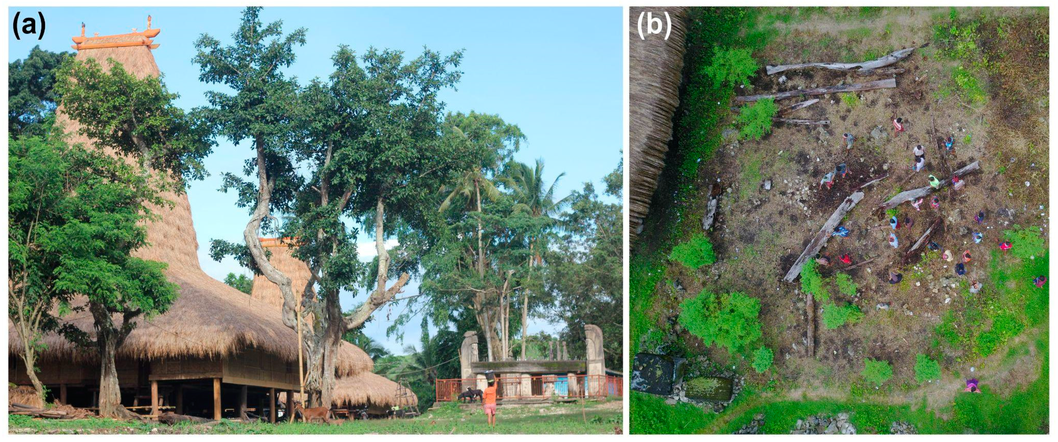
The traditional villages are well known for their striking indigenous houses with extremely tall roofs (Figure 2a). These have taken on a special importance in recent years, and have seen interest in making Sumba a key tourist destination, which parallels some of the success of Bali [16], so their protection assumes greater priority. The ancestors, whose spirits are said to occupy the upper levels of the roof space, are entombed in megalithic monuments that are typically built in a central plaza, aligned in a north–south direction. The island of Sumba is one of the few places where neolithic/bronze-age burials in megaliths still take place. The buildings are constructed of timber frames with a roof thatched with alang-alang grass (Imperata cylindrica). Walls are made from panels of plaited bamboo or woven coconut leaf, and the roof from a thick layer of thatch bound to sapling battens with coconut leaves. Houses may be family dwellings or larger communal facilities for wedding ceremonies, funerals and the residence of the village elder. Their design and the steep high pitch reflect the close association of the Sumbanese people with the Marapu religion of the island [17]. The houses are constructed in consultation with the ancestors, through haruspication and other ceremonies, as witnessed on field visits. Thus, fire protection is not a primary concern in a situation where effort is needed to maintain the traditional design as there is a fear that knowledge of construction techniques is being lost as part of the general difficulties in preserving Sumbanese culture [18]. This has led to the creation of centers such as the Sumba Cultural Research and Conservation Institute (Rumah Budaya Sumba; Jl. Rumah Budaya No. 212, Kalembu Nga, bangga Weetebula, Kabupaten Sumba Barat Daya, Nusa Tenggara Timur).
Indonesia has been developing regulations that adopt international standards for fire protection of buildings under the Ministry of Public Works Regulation No. 26/PRT/M/2008. Regulation has improved, but even in cities [19] there have been struggles with corruption [20] and limited awareness of the complexity of the issue [21]. The situation is more difficult in remote areas, such that recent years have seen a number of catastrophic fires in traditional Indonesian villages (Figure 2b) where fire represents a notable threat [22]. Such fires typically lead to the total collapse of buildings, with just a few supports remaining. The villages have only a few dozen houses and, as seen in Table 1, ~80% of the structures are lost. The records of village fires in Indonesia are far from complete, but those available provide some examples of some accounts of notable fires from Indonesian villages over the last five years (Table 1) [23,24]. The traditional buildings in Sumbanese villages crowd close together, which allows for the rapid crossover of fire between one building and another, as found at other sites, such as densely packed (tette trehusmiljø) Norwegian villages [13] or informal settlements in Africa [25]. These Sumbanese houses have become part of the Watch 2022 list of the World Monuments Fund. More recently, the fires have promoted special concern that has justified their inclusion in their crisis response program, which supports sites physically affected by disruptive events. This effort serves as inspiration for the current research. Traditional Sumbanese villages are poorly protected from fire, given that they are constructed from combustible materials, so fires spread rapidly. The villages have no standardized system of alarm and there is little local firefighting capability, and they are often remote from contemporary infrastructure. Additionally, there are often difficulties in obtaining the large amount of water needed to fight the fires.
Ratenggaro village in the west of the island lost all but two of its thirty-two houses to fire in 2004 [18] and Tarung Village caught fire in October 2017, which increased the public interest in the village [23]. The origin of the fires is uncertain. Locals believe that these may derive from the spirits being angry. Given the height of the roof and a ridge pole with decorative pointed ends, there is a possibility of lightning strikes, which can be a problem with thatched roofs [26]. In the Nusa Tenggara islands, cooking takes place in the open plan interior that is regarded as the women’s room, which is treated as a kitchen and is also used for rice storage [17], but there are additional concerns about smoking being the cause of the fires. However, as many of the fires start in the roof, lightning remains a possible cause (as mentioned by villagers during field visits). Lightning frequency and climate change were also a problem for the environment around the shrines of Nikkō [6,27]. Finney et al. [28] suggested a decrease in lightning frequency with climate change, but Veraverbeke et al. [29] noted the role of lightning as a main factor driving major fire years in North American boreal forests.
In Sumba, there is concern that fires in the grasslands may be increasing in frequency. Fisher et al. [30] used remote sensing (LANDSAT advanced very-high-resolution radiometer and moderate-resolution imaging spectroradiometer sensors) to investigate the fire regimes of the semiarid Nusa Tenggara islands and found that fires burnt ~29% of the area of eastern Sumba in a year. Although the great majority of individual fires were less than 5 ha, some late dry-season fires were hundreds of hectares in extent. Yulianti et al. [31] examined the trends in Indonesian forest fires and suggested that the period of the most frequent fire occurrence in the Indonesian Archipelago are the three dry months: August, September and October.
The Indonesian government has tried to reduce the amount of biomass burning to reduce transnational air-pollutant haze and lower carbon emissions [31]. However, Tacconi et al. [32] pointed out that fire “is widely used in swidden agricultural activities and in grassland management in both Flores and Sumba”. Such use of fire is common in the tropics, but an increasing population and intensified agriculture have led to a decrease that is associated with shifting cultivation [33]. Annual fires on grasslands are mostly now used to improve visibility for hunting and to encourage regrowth for grazing. Sutomo and van Etten [34] mapped the fires across Indonesia and have shown the significance of the grasslands, especially those of Sumba, in contributing to the number of MODIS hotspots.

1.3. Current Study

Most studies of heritage fires are for historic urban areas [35], so they are not directly applicable to remote villages, although some studies of fire and heritage in remote areas are available [36]. It can be difficult to develop a fire-risk assessment for isolated heritage sites where data can be limited or inaccessible and architecture poorly studied. The timber heritage in places such as Sumba may be further at risk as parts of the tropics are likely to become less humid [37,38]. This paper examines the fires with a particular interest in the potential climate effects on fire risk on Sumba, along with an examination of the changing climate in the Nusa Tenggara Timur. It hopes to establish a relationship between climate and fires, and so aid the development of plans to reduce the outbreaks and encourage more effective control of fires.

2. Materials and Methods

The paper uses field observations from the island along with some internet collections relating to village fires. The latter are neither comprehensive nor definitive, but they provide accessible records of village fires in Indonesia, e.g., Kompas.com [24] regional news. In addition, we used a range of meteorological data. (i) Regular observations of climate are available at hourly intervals from Maumere/Wai Oti [39], some 200 km to the north of Sumba on the island of Flores. There is limited availability of observations from Sumba, although some 30-year summary data for Waingapu were available at the World Climate Guide [40]. (ii) The regional climate for Nusa Tenggara Timur was found as part of the homogenized historical series from 1901–2021 from the Climate Research Unit (CRU) [41]. (iii) The reanalysis product, ERA5, is a fifth-generation product that provides 70 years of monthly global meteorological data (1950–2020) and there are historic projections (1985–1915) and (iv) forward projections (2015–2100) from CMIP6 (coupled model intercomparison project). These CRU, ERA5 and CMIP6 date sets have been accessed through the World Bank Climate Change Knowledge Portal [42]. The key parameters in our analysis were temperature (though not much used), precipitation, relative humidity and the number of consecutive dry days (CDD), which is the largest number of consecutive days with daily precipitation less than 1 mm, i.e., consecutive days without rain.
Satellite observations have been used to study Sumba and its architecture and, more broadly, to assess the risk imposed by the surrounding landscape [43]. In this work, we used imagery available from the MODIS (moderate-resolution imaging spectroradiometer) on the Terra satellite launched in 1999 as it provides a long and continuous series. Fires and thermal anomalies, day and night, provide a record of fires on Sumba since 2001. Although a few days seem missing, overall, the observations provide a long record. The hotspots were counted from images available on the NASA Worldview website for the dry-season months of July to September [44]. Although the number of hotspots is reasonably reliable, the estimated area burnt is more difficult to establish [45], so it has not been attempted here. A shorter record (2019–2021) that included all the months was used to examine the seasonal variation of fires.
Statistical analysis had to consider the skewed nature of some of the meteorological parameters, most notably the dry-season rainfall. We often adopted the median to represent central tendency and lower and upper quartiles as dispersion because the data did not necessarily follow a normal distribution. Trends used the Theil–Sen slope [46] or median slope, along with the Kendall τ statistic as a nonparametric measure association between two sets of measurements. The application of statistics to problems in the remote sensing of heritage is given in Agapiou et al. [47].

3. Results

The records of village fires in Indonesia are far from complete, but those available provide some examples of some accounts of notable fires from Indonesian villages over the last five years, as listed in Table 1 [23,24]. These fires occurred between July and September, thus typically taking place in the April-to-September dry season that is linked to the monsoons. Very recently, a fire occurred in a notable village in the Southwest Sumba Regency, Kampung Wainyapu, with the loss of 30 houses—a loss estimated at more than a quarter million U.S. dollars.
Although the records of house fires on Sumba are limited, satellite observations provide a fairly continuous picture of the overall number of fires, most of which are on grasslands [34]. Figure 3a shows the average monthly number of hotspots from the Terra satellite (MODIS night and day) imagery for the 2019–2021 period. The seasonal pattern of grassland fires on Sumba could be a function of the seasonal activities to village life, but it is notable that most of the fires occur in June–November. This shows that fires are most frequent during the dry season and indicates a seasonal pattern that agrees with rainfall amounts for Waingapu for 1991–2020 (Figure 3b) and relative humidity for Maumere/Wai Oti for 2005–2015 (Figure 3c). Over the 1901–2021 period, there was little change in rainfall and, although there was a positive Theil–Sen slope of about a millimeter per year, the significance from a Kendall τ test was low (p~0.25). Relative humidity shows a distinct cycle, with the lowest values in August. The ERA5 reanalysis for Nusa Tenggara Timur shows a very slight decrease in relative humidity over the 1970–2020 time period (Theil–Sen slope of −1.02% per century, but Kendall τ: p~0.25).
The change in the number of hotspot anomalies for July–September as detected by MODIS day and night imagery (Figure 4a) suggest that fires in Sumba showed no particular trend over two decades (Theil–Sen slope −0.8 per year, Kendall τ = 0.1, p2 = 0.5). However, there is evidence of an inverse relationship with the July–September rainfall for Nusa Tenggara Timur from the CRU monthly data. Figure 4b shows that the number of fires in July–September to be well correlated (Kendall τ = 0.5, p2 < 0.0025) with consecutive dry days (rainfall < 1 mm). These correlations suggest that there is a strong association between the total number of fires observed from MODIS during the dry season and periods of low rainfall.
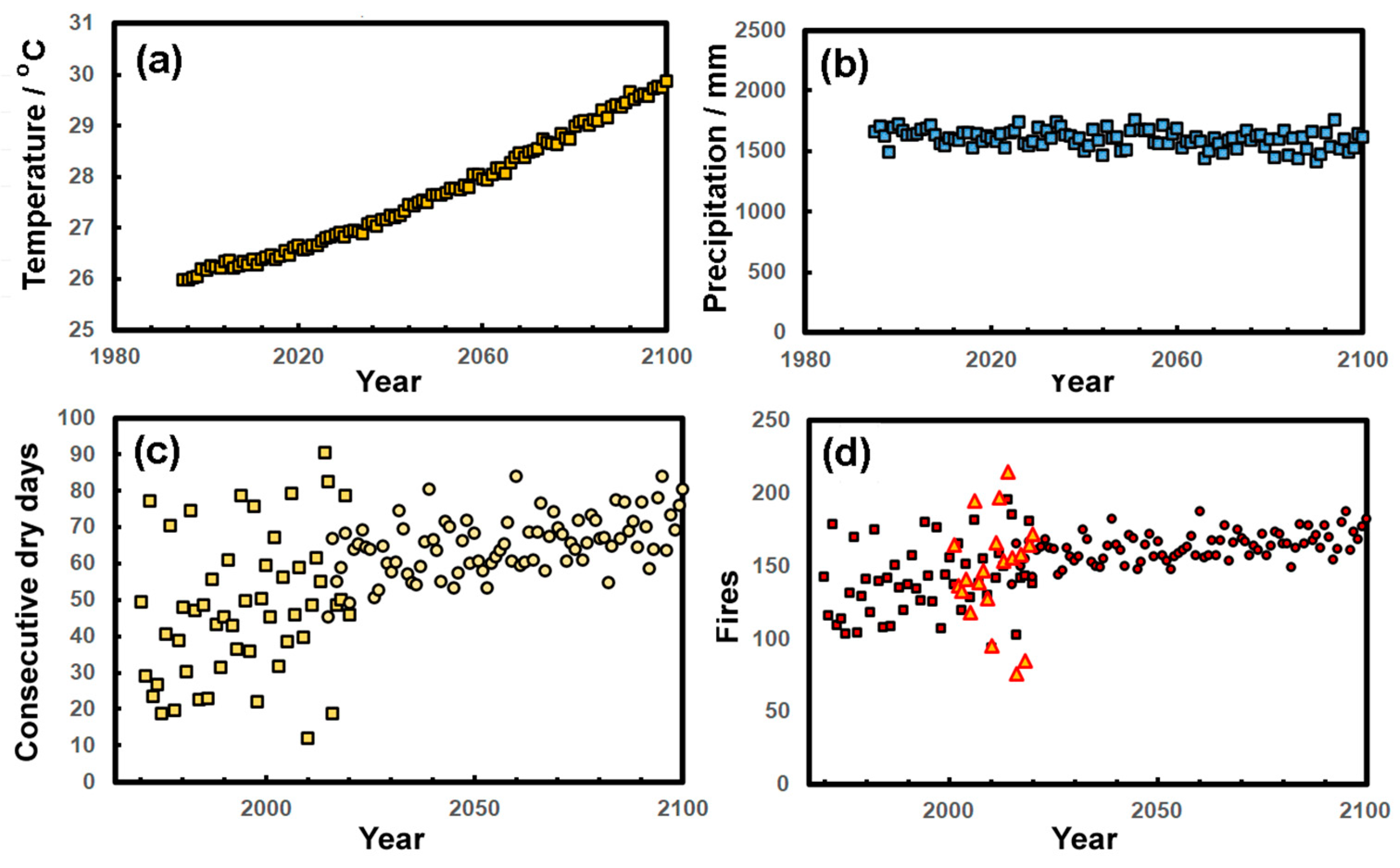
The change in essential climate parameters, temperature and precipitation for Nusa Tenggara Timur from the CMIP6 ensemble models are shown in Figure 5a,b. Although there is a noticeable change in the projected temperatures over the coming century, there is little change in projected precipitation in the region. However, the precipitation is distributed differently in terms of rainfall amounts, as revealed in the number of consecutive dry days, which increases across 170 years in the ERA5 and CMIP6 projections. Correlation between fires (nF) and the annual number of consecutive dry days (nCDD) using the parametric Pearson statistic suggested a relationship: nF = 1.292 nCDD + 78.8 (R² = 0.54), using the data plotted in Figure 4b. This relationship allowed us to estimate the number of dry-season fires over more extended periods (Figure 5d) and suggested a gradual increase over time in line with the increasing length of dry spells.

4. Discussion

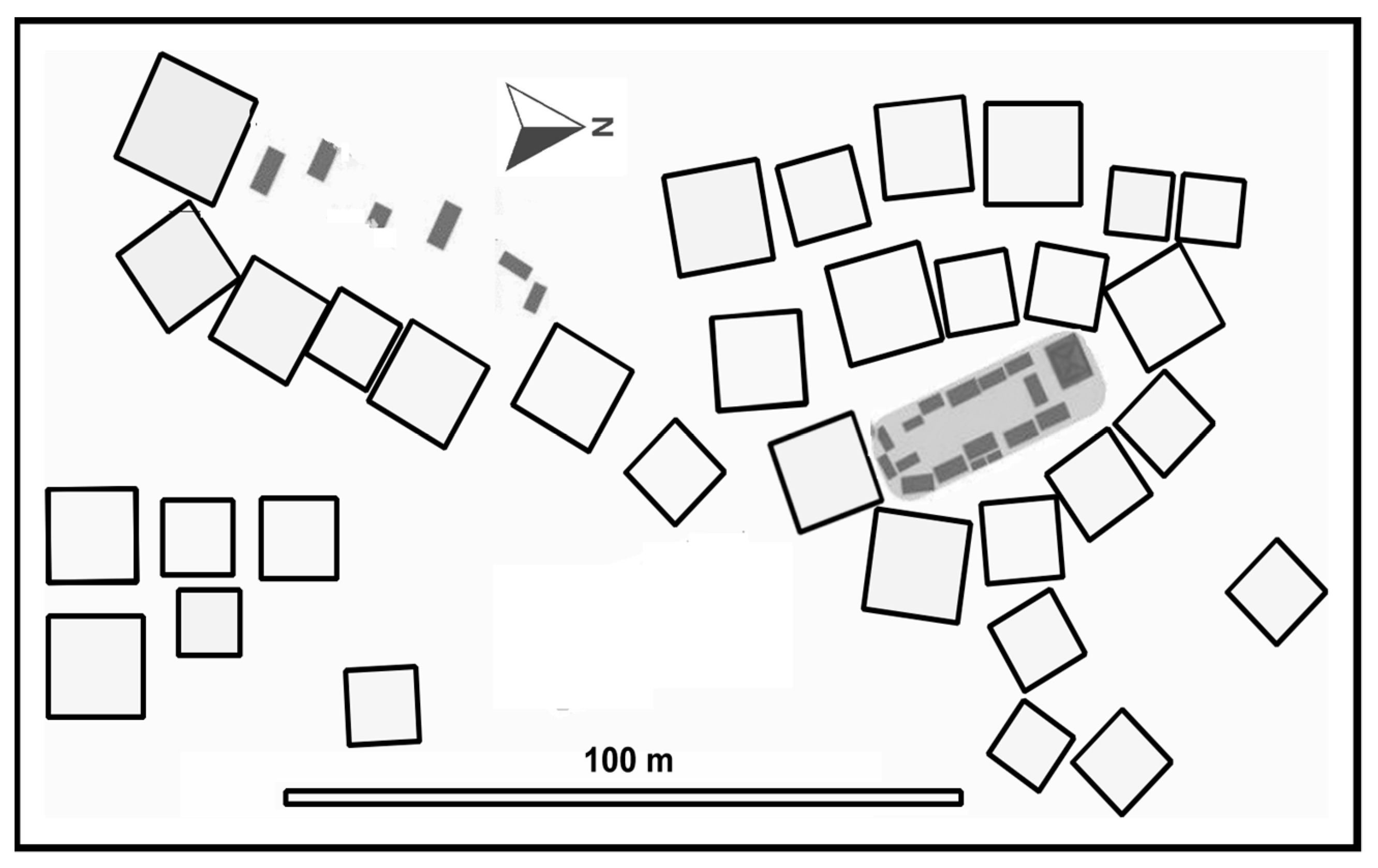
The increase in likely occurrence of fires suggested by Figure 5d suggests that changing climate may lead to an increased fire frequency. However, care is needed in interpreting this as many other issues are likely to alter the occurrence of fires in the future, most notably changing social and agricultural practices. Nevertheless, the increasing length of dry spells in the future suggests an enhanced number of fires. Given the serious loss in recent fires, as listed in Table 1, there is a clear need to investigate approaches for lowering the number of fires in the traditional Sumbanese villages. Improved access is difficult because the close integration of the architecture with the Marapu religion means that any changes will require a broad approval of key figures in village life. The villages are crowded, the roofs are high and access is difficult, with some houses often abutting each other (Figure 6), so fires are able to spread rapidly. The village layout is difficult to change given the large stone tombs of ancestors that are interspersed with buildings.
As the houses are built from materials that are extremely flammable, and while it is important to retain these materials, it might be possible to treat them with fire retardants. Such solutions for historic buildings have been a little difficult because these treatments are most effective when the original building materials are treated before construction [48]. However, as the thatch is replaced fairly often, the retardants might be effective as they could be used to treat the grasses prior to placement as thatch. Alum (potassium aluminum sulfate) has been used as a fire retardant for wood and other additives, such as copper sulfate [49], are useful in reducing biological damage in thatch. Thatched roofs can also be made more fire-resistant by incorporating roofing materials that are plastered with a mud, which also makes it more durable [49,50], but this might not be locally acceptable. Computational fluid dynamics (CFD) has proved a valuable tool in understanding the spread of fire in historic buildings [12], so it would be useful to use such techniques or test burns [51] to assess whether some arrangements of the vertical spaces in Sumbanese interiors are less prone to a rapid spread of fire than others.
The key sources of fire in many historic dwellings are cooking activities and lightning strikes [13]. Care in the layout of the cooking space might reduce risk, although this might face opposition from the community. Lightning protection would be possible by way of a conducting mesh in the thatched roof or a tall mast [26]; the latter would have some advantages when positioned centrally in the village or around the perimeter as it could offer protection to a large number of buildings.
Early discovery of the fires is important given the rapidity of spread within the villages. Infrared hotspot and smoke detection have both been successful [13]. While smoke detection is inexpensive, it may be that remote infrared scans of the village would be more suitable for outdoor fires [13] but requires a source of funding. Once fires have started, it is important to have large quantities of water available to extinguish them. Some villages (e.g., in Bodo Indigenous Village Ede near Tarung) already have tanks on tall frames for domestic water; these could be enlarged, but water is in short supply on Sumba, which is one of the driest parts of Indonesia. A problem with extinguishing fires is that the tall roofs are ~20 m high, so powerful pumps might be necessary to reach such heights. Kristoffersen and Log [13] argued that “Fire safety plans for wooden towns often emphasize early fire detection and fire service intervention. This is, however, dependent on the fire service response time”. This latter aspect is hardly relevant to Sumba as the intervention of a fire service, even if it exists locally, would be difficult given access problems. This means that the response needs to be local, so giving courses on practical firefighting could be effective.
There are current plans to consult the local villagers and explore the possibilities of future fire protection. This might involve the detection of fires, enhancing fire-resistance of building materials and improving methods to combat any fires that occur. It will be necessary to consider the methods that are likely to be effective in these remote communities, yet do not offend their traditional practices. Consultation with village elders is important [52], but fire protection will require the entire village to be engaged as it would be best seen as a community responsibility. Such consultations with the community have even gone beyond conventional approaches and used a medium to contact the spirits integrated within the heritage objects [53].

5. Conclusions

Fires in traditional Sumbanese villages have proved catastrophic in the past, often meaning the loss of almost all of the dwellings. Future climate with increasingly long spells of dry weather would enhance the potential for fires. Remoteness and difficult access make fire suppression by fire services a problem. Solutions may require making the building materials more fire-resistant (fire-retardant chemicals), improving knowledge of how fires spread in the tall structures and the early detection of fires. There is a need for further research on the suitability and acceptability of technical interventions, but we also plan consultations with villagers from across the island. Such work would align with Sustainable Development Goal 11 and aim to make the settlements more inclusive, safer, more resilient and sustainable. Training village residents in firefighting techniques and the provision of pumps and stores of water would help bring any fires under control more rapidly.

Author Contributions

Initial investigation, S.T.; methodology, P.B.; formal analysis, P.B.; investigation and fieldwork, S.T.; writing, P.B.; visualization, P.B. All authors have read and agreed to the published version of the manuscript.

Funding

This research received no external funding.

Data Availability Statement

Data supporting the analysis made in the study can be found in the publicly archived datasets at the URLs given in the reference list.

Acknowledgments

We would like to acknowledge the role of Jeff Allen of the World Monuments Fund in bringing the authors together to discuss this problem.

Conflicts of Interest

The authors declare no conflict of interest.

References

  1. Sung, C.; Leonov, V.; Waters, P. Fire Recovery at the Library of the Academy of Sciences of the USSR. Am. Arch. 1990, 53, 298–312. [Google Scholar] [CrossRef] [Green Version]
  2. Dallas, R.W.A.; Kerr, J.B.; Lunnon, S.; Bryan, P.G. Windsor Castle: Photogrammetric and archaeological recording after the fire. Photogramm. Rec. 1995, 15, 225–240. [Google Scholar] [CrossRef]
  3. Restelli, A.B.; Tornaghi, R.; Pettinaroli, A.; Rovetto, E. Reconstruction of La Fenice theatre in Venice. Foundation problems. In Proceedings of the XIII European Conference on Soil Mechanics and Geotechnical Engineering, Prague, Czech Republic, 25 August 2003; Volume 2, pp. 29–34, ISBN 80-86769-01-1. [Google Scholar]
  4. Ferreira, T.M. Notre Dame Cathedral: Another case in a growing list of heritage landmarks destroyed by fire. Fire 2019, 24, 20. [Google Scholar] [CrossRef] [Green Version]
  5. Fire in China’s Last Remaining Primitive Tribe under Control, Only 4 Straw Huts Remain Intact. Available online: https://www.globaltimes.cn/page/202102/1215635.shtml (accessed on 10 November 2022).
  6. Brimblecombe, P.; Hayashi, M. Pressures from long term environmental change at the shrines and temples of Nikkō. Herit. Sci. 2018, 6, 27. [Google Scholar] [CrossRef] [Green Version]
  7. Okubo, T. Traditional wisdom for disaster mitigation in history of Japanese architectures and historic cities. J. Cult. Herit. 2016, 20, 715–724. [Google Scholar] [CrossRef]
  8. Resource Manuals. Available online: https://whc.unesco.org/en/resourcemanuals/ (accessed on 10 November 2022).
  9. Stovel, H. Risk Preparedness: A Management Manual for World Cultural Heritage; ICCROM: Rome, Italy, 1998. [Google Scholar]
  10. Ibrahim, M.N.; Ibrahim, M.S.; Mohd-Din, A.; Abdul-Hamid, K.; Yunus, R.M.; Yahya, M.R. Fire risk assessment of heritage building–perspectives of regulatory authority, restorer and building stakeholder. Procedia Eng. 2011, 20, 325–328. [Google Scholar] [CrossRef] [Green Version]
  11. Yuan, C.; He, Y.; Feng, Y.; Wangn, P. Fire hazards in heritage villages: A case study on Dangjia Village in China. Int. J. Disaster Risk Reduct. 2018, 28, 748–757. [Google Scholar] [CrossRef]
  12. Huang, Y.H. The use of parallel computing to accelerate fire simulations for cultural heritage buildings. Sustainability 2020, 12, 10005. [Google Scholar] [CrossRef]
  13. Kristoffersen, M.; Log, T. Experience gained from 15 years of fire protection plans for Nordic wooden towns in Norway. Saf. Sci. 2022, 146, 105535. [Google Scholar] [CrossRef]
  14. Sumba Fundation Water. Available online: https://sumbafoundation.org/projects/water/ (accessed on 7 October 2022).
  15. Wikipedia Sumba. Available online: https://en.wikipedia.org/wiki/Sumba (accessed on 11 October 2022).
  16. The Next Bali, Sumba, Is Becoming a Social Model for Other Indonesian Islands. Available online: https://www.indosurfcrew.com/the-next-bali-sumba/ (accessed on 7 October 2022).
  17. Solikhah, N.; Bere, A.F. Vernacular Architecture as a Representation of Nature, Self, Culture, and Society: Insights from Sumba-Timor-Flores. In Proceedings of the International Conference on Economics, Business, Social, and Humanities (ICEBSH 2021), Jakarta, Indonesia, Jakarta, Indonesia, 17–18 February 2021; Atlantis Press: Paris, France, 2021; pp. 1502–1509. [Google Scholar]
  18. Yusran, Y.A. The Ebb Tide in Conserving Nusantara Architecture. Procedia Eng. 2016, 161, 1343–1352. [Google Scholar] [CrossRef]
  19. Amin, M.; Alisjahbana, S.W.; Simanjuntak, M.R. Analysis model of master plan fire protection system in building and environment in DKI Jakarta-Indonesia. Int. J. Civ. Eng. Technol. 2018, 9, 60–69. [Google Scholar]
  20. Kuncoro, A. Corruption and business uncertainty in Indonesia. ASEAN Economic Bulletin 2006, 11–30. [Google Scholar] [CrossRef]
  21. Suryoputro, M.R.; Buana, F.A.; Sari, A.D.; Rahmillah, F.I. Active and passive fire protection system in academic building KH. Mas Mansur, Islamic University of Indonesia. In MATEC Web of Conferences 2018; EDP Sciences: Les Ulis, France, 2018; Volume 154, p. 01094. [Google Scholar]
  22. Poerwoningsih, D.; Tutut Subadyo, A.; Wahjutami, E.L.; Santoso, I.; Winansihm, E. Bioregion Concept for the Landscape of Traditional Village in West Sumba, East Nusa Tenggara, Indonesia. In Conserving Biocultural Landscapes in Malaysia and Indonesia for Sustainable Development; Springer: Singapore, 2022; pp. 33–50. [Google Scholar]
  23. Solikhah, N.; Tunjungsari, H.K.; Mulyawan, B. Exploration of Tarung Village, West Sumba as a Part of the Road Map for the Development of Cultural Tourism Based on Sustainable Tourism Approach. In Proceedings of the 2nd Tarumanagara International Conference on the Applications of Social Sciences and Humanities (TICASH 2020), Jakarta, Indonesia, 3–4 August 2020; Atlantis Press: Paris, France, 2020; pp. 1066–1073. [Google Scholar]
  24. Kompas.com. Available online: https://regional.kompas.com (accessed on 7 October 2022).
  25. Walls, R.; Olivier, G.; Eksteen, R. Informal settlement fires in South Africa: Fire engineering overview and full-scale tests on “shacks”. Fire Saf. J. 2017, 91, 997–1006. [Google Scholar] [CrossRef]
  26. Chachaia, F.H. Lightning Protection of Thatched Roofed Structures. Ph.D. Thesis, Faculty of Engineering and the Built Environment, University of the Witwatersrand, Johannesburg, Johannesburg, South Africa, 2006. [Google Scholar]
  27. FDMA. Fire: White Paper; Tokyo, Shobi, Fire and Disaster Management Agency of the Ministry of Internal Affairs and Communications: Tokyo, Japan, 2015. [Google Scholar]
  28. Finney, D.L.; Doherty, R.M.; Wild, O.; Stevenson, D.S.; MacKenzie, I.A.; Blyth, A.M. A projected decrease in lightning under climate change. Nat. Clim. Chang. 2018, 8, 210–213. [Google Scholar] [CrossRef] [Green Version]
  29. Veraverbeke, S.; Rogers, B.M.; Goulden, M.L.; Jandt, R.R.; Miller, C.E.; Wiggins, E.B.; Randerson, J.T. Lightning as a major driver of recent large fire years in North American boreal forests. Nat. Clim. Chang. 2017, 7, 529–534. [Google Scholar] [CrossRef]
  30. Fisher, R.; Bobanuba, W.E.; Rawambaku, A.; Hill, G.J.; Russell-Smith, J. Remote sensing of fire regimes in semi-arid Nusa Tenggara Timur, eastern Indonesia: Current patterns, future prospects. Int. J. Wildland Fire 2006, 15, 307–317. [Google Scholar] [CrossRef]
  31. Yulianti, N.; Hayasaka, H.; Usup, A. Recent forest and peat fire trends in Indonesia the latest decade by MODIS hotspot data. Glob. Environ. Res. 2012, 16, 105–116. [Google Scholar]
  32. Tacconi, L.; Ruchiat, Y. Livelihoods, fire and policy in eastern Indonesia. Singap. J. Trop. Geogr. 2006, 27, 67–81. [Google Scholar] [CrossRef]
  33. McWilliam, A. Historical reflections on customary land rights in Indonesia. Asia Pac. J. Anthropol. 2006, 7, 45–64. [Google Scholar] [CrossRef]
  34. Sutomo; van Etten, E. Spatial and temporal patterns of fires in tropical savannas of Indonesia. Singap. J. Trop. Geogr. 2018, 39, 281–299. [Google Scholar] [CrossRef]
  35. Ferreira, T.M.; Vicente, R.; da Silva, J.A.; Varum, H.; Costa, A.; Maio, R. Urban fire risk: Evaluation and emergency planning. J. Cult. Herit. 2016, 20, 739–745. [Google Scholar] [CrossRef] [Green Version]
  36. Mallinis, G.; Mitsopoulos, I.; Beltran, E.; Goldammer, J.G. Assessing wildfire risk in cultural heritage properties using high spatial and temporal resolution satellite imagery and spatially explicit fire simulations: The case of Holy Mount Athos, Greece. Forests 2016, 7, 46. [Google Scholar] [CrossRef]
  37. Richards, J.; Brimblecombe, P. Moisture as a Driver of Long-Term Threats to Timber Heritage. Part I: Changing Heritage Climatology. Heritage 2022, 5, 1929–1946. [Google Scholar] [CrossRef]
  38. Brimblecombe, P.; Richards, J. Moisture as a Driver of Long-Term Threats to Timber Heritage. Part II: Risks Imposed on Structures at Local Sites. Heritage 2022, 5, 2966–2986. [Google Scholar] [CrossRef]
  39. Timeanddate. Available online: https://www.timeanddate.com (accessed on 9 October 2022).
  40. Climate-Sumba (Indonesia). Available online: https://www.climatestotravel.com/climate/indonesia/sumba (accessed on 7 October 2022).
  41. High-Resolution Gridded Datasets (and Derived Products). Available online: https://crudata.uea.ac.uk/cru/data/hrg/ (accessed on 5 October 2022).
  42. Climate Change Knowledge Portal. Available online: https://climateknowledgeportal.worldbank.org (accessed on 11 October 2022).
  43. Monna, F.; Rolland, T.; Denaire, A.; Navarro, N.; Granjon, L.; Barbé, R.; Chateau-Smith, C. Deep learning to detect built cultural heritage from satellite imagery.-Spatial distribution and size of vernacular houses in Sumba, Indonesia. J. Cult. Herit. 2021, 52, 171–183. [Google Scholar] [CrossRef]
  44. NASA Worldview. Available online: https://worldview.earthdata.nasa.gov (accessed on 11 October 2022).
  45. Hantson, S.; Padilla, M.; Corti, D.; Chuvieco, E. Strengths and weaknesses of MODIS hotspots to characterize global fire occurrence. Remote Sens. Environ. 2013, 131, 152–159. [Google Scholar] [CrossRef]
  46. Vannest, K.J.; Parker, R.I.; Gonen, O.; Adiguzel, T. Single Case Research: Web Based Calculators for SCR Analysis. (Version 2.0) [*Web-Based Application]; Texas A&M University: College Station, TX, USA, 2016; Available online: http://singlecaseresearch.org/calculators/theil-sen (accessed on 3 October 2022).
  47. Agapiou, A.; Lysandrou, V.; Themistocleous, K.; Hadjimitsis, D.G. Risk assessment of cultural heritage sites clusters using satellite imagery and GIS: The case study of Paphos District, Cyprus. Nat. Hazards 2016, 83 (Suppl. 1), 5–20. [Google Scholar] [CrossRef]
  48. Laranjeira, J.P.; Cruz, H.; Pinto, A.P.; Pina dos Santos, C.; Pereira, J.F. Reaction to fire of existing timber elements protected with fire retardant treatments: Experimental assessment. Int. J. Archit. Herit. 2015, 9, 866–882. [Google Scholar] [CrossRef]
  49. Chowdhury, S.; Roy, S. Prospects of low cost housing in India. Geomaterials 2013, 3, 60–65. [Google Scholar] [CrossRef] [Green Version]
  50. Sambare, P.; Bongirwar, R.; Sinhal, S.; Tiwari, M. Post earthquake housing construction using low cost building materials. In Proceedings of the International Conference on Advances in Architecture and Civil Engineering (AARCV 2012), Bangalore, India, 21–23 June 2012; Volume 21, p. 848. [Google Scholar]
  51. Friede, H.M.; Steel, R.H. Experimental burning of traditional Nguni huts. Afr Stud. 1980, 39, 175–181. [Google Scholar] [CrossRef]
  52. Warrack, S. Learning from local leaders: Working together toward the conservation of living heritage at Angkor Wat, Cambodia. Chang. Over Time 2011, 1, 34–51. [Google Scholar]
  53. Warrack, S. Involving The Local Community in the Decision Making Process: The German APSARA Project at Angkor Wat (2007). Archaeological Sites: Conservation and Management; Mackay, S.S., Ed.; Getty Conservation Institute: Los Angeles, CA, USA, 2012; pp. 626–634. [Google Scholar]
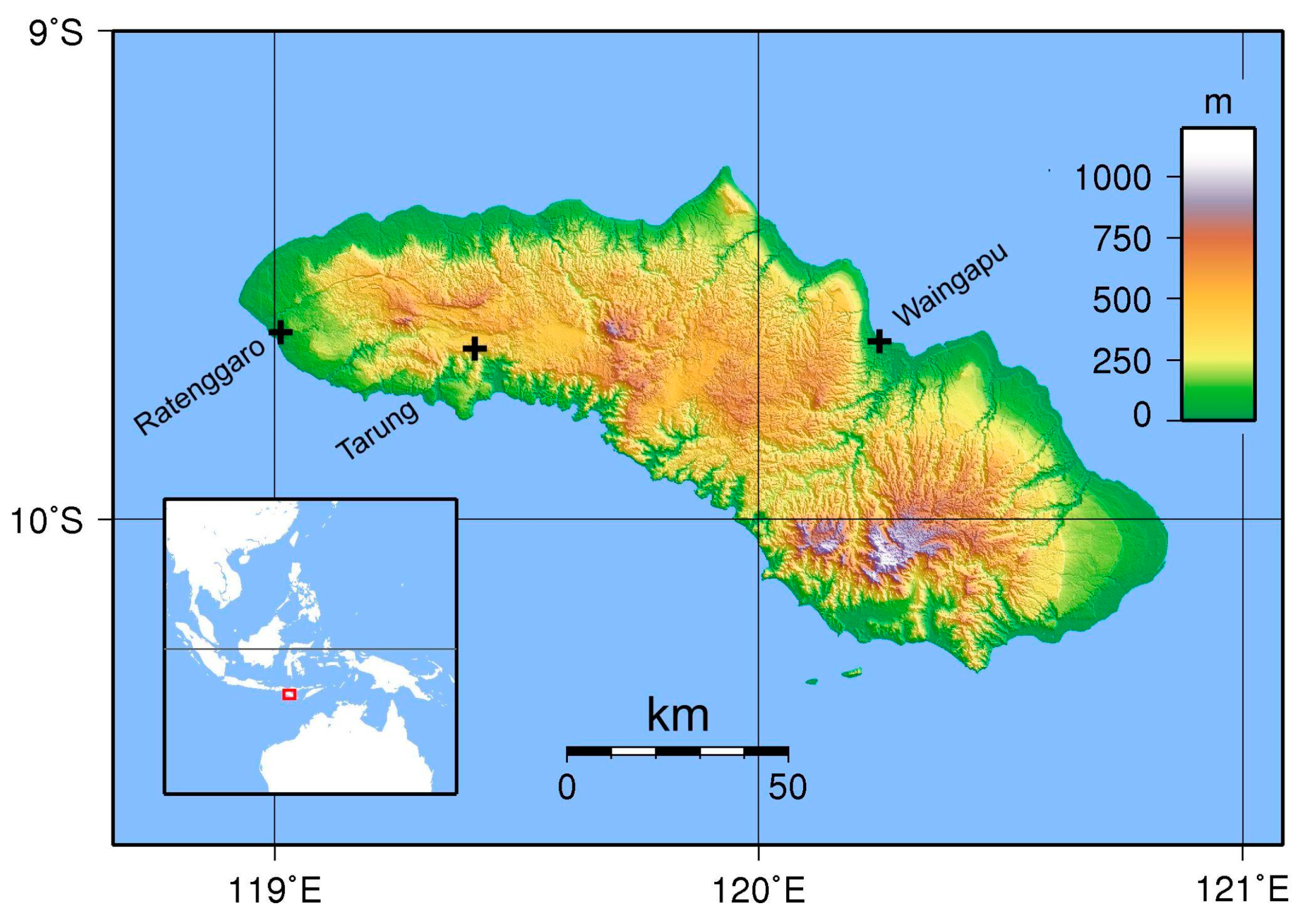
Figure 1. Map of Sumba showing locations relevant to this study. Base map created with GMT from SRTM (shuttle radar topography mission) data by Sadalmelik [15].
Heritage 05 00187 g001
Figure 2. (a) Sumba village scene and (b) aerial view of complete destruction after the fire at Kampung Waikaninyu. Photographs by author S.T.
Heritage 05 00187 g002
Figure 3. (a) Average number of fires in Sumba detected by satellite from 2019 to 2021 from MODIS data. (b) Monthly precipitation from the observed averages from Waingapu on Sumba for 1991–2020. (c) Monthly average RH from Maumere/Wai Oti for 2005–2015.
Heritage 05 00187 g003
Figure 4. (a) Number of fires each year (red squares) in Sumba detected during the July–September fire season from MODIS on the Terra satellite and rainfall (blue diamonds) from the CRU dataset for Nusa Tenggara Timur (2001–2020). (b) Number of fires each year in Sumba detected during the July–September fire season as a function of the annual number of consecutive days without rain from the ERA5 data for Nusa Tenggara Timur (2001–2020).
Heritage 05 00187 g004
Figure 5. (a) Mean annual temperature from CMIP6 for Nusa Tenggara Timur. (b) Annual precipitation from CMIP6 for Nusa Tenggara Timur. (c) Number of consecutive days each year in Nusa Tenggara Timur, estimated from 1970 to 2100, with squares from the ERA5 data and the circular symbols for CMIP6 projections for 2015–2100. (d) Number of fires each year during the July–September fire season predicted for Sumba (1970–2100), with squares from the ERA5 and circular symbols for the CMIP6 projections. Observed numbers of fires detected from satellites are marked with red and yellow triangles for the 2001–2020 period.
Heritage 05 00187 g005
Figure 6. Layout of Kampung Tarung in Waikaboebak, West Sumba Regency, Nusa Tenggara Timur. Adapted from satellite imagery and Solikhah et al. [23], with buildings as squares and darker grey marking denoting the areas of megalithic tombs.
Heritage 05 00187 g006
Table 1. Recent fires in traditional villages of Indonesia. Note K. = Kampung.
Date of FireImpact
1 October 201728 houses
13 August 201827 houses and 6 huts
25 July 201912 houses
10 August 202022 houses
30 August 202028 of 36 houses
27 September 202025 houses
Publisher’s Note: MDPI stays neutral with regard to jurisdictional claims in published maps and institutional affiliations.