Abstract
Previous research has highlighted the correlation between the design of the built environment and sustainable development, underscoring how buildings have the potential to accelerate the realization of the SDGs. However, the specific contribution of built heritage to the SDGs have been seldom studied, and little research has attempted to link built heritage architectural features with sustainable development. This research examines how heritage façades, and the street-level activities they instigate, contribute to local sustainable development. The researchers build on existing knowledge to develop a framework that links façade features with the SDGs. The framework is used to re-examine several case studies in El Korba, located in Heliopolis, Cairo (Egypt). Many researchers have studied this area architecturally, historically, and socially, but no research has studied its possible contribution to local sustainable development. The findings highlight how those heritage façades serve as a means for sustainable development on the social, economic, and environmental levels. The paper also underscores how the deterioration of this built heritage location risks diluting the architectural features that drive their contribution to the SDGs. The findings also substantiate several of the connections in the framework, which enables future researchers to link the design features of heritage building façades and the SDGs and document how different built heritage locations support sustainable development.
1. Introduction
Initially, the notion of cultural heritage only considered “objects of culture” [1], which included historical monuments, groups of buildings, or sites of “outstanding universal value from the point of view of history, art or science” [2]. However, since the 1960s, researchers have been working to institutionalize a more holistic definition of heritage, which combines intangible inheritances [1]. These types of intangible assets are non-physical by definition and comprise “oral traditions and expressions, including language as a vehicle of the intangible cultural heritage; performing arts; social practices, rituals, and festive events; knowledge and practices concerning nature and the universe; [and] traditional craftsmanship” [2]. “This broader interpretation of heritage marks a shift in the understanding of heritage space” [1]. In this holistic definition, things such as “the everyday” of the people who live in or visit a historical site become part and parcel of the location’s heritage. The expanded definition thus combines both the tangible and intangible, rather than separating them into two different categories of heritage.
The developments in the definition and understanding of heritage are critical for studying how built heritage contributes to sustainable development. Understanding that built heritage represents tangible and intangible physical value, and it is through its tangible and visible layers that the built space physically hosts and facilitates the opportunities for maintaining its intangible values. This cyclical understanding is more fit for locations where heritage and traditions are very closely knit in the communities and everyday actions, especially those living in historical residential areas [3]. The daily activities of inhabitants and users of spaces can be considered critical to a location’s heritage, which are facilitated by the material component of the space [4]. More importantly, the physical space that enables and facilitates such activities becomes a prerequisite for maintaining and supporting the living heritage of a site [3,5,6,7,8,9,10].
Researchers have studied the correlation between building design and street social activity. Theorists have also stressed the importance of place-making and social interaction between people in the design of cities. For instance, in the “5 Rules for Designing Great Cities”, Jan Gehl points to the need to design for multisensory experiences, making public life the driver of urban design [8]. Moreover, in “Eyes on the Street”, Jane Jacobs [10] argues that buildings promoting social activities on the street yield better surveillance. In The Production of Space, Henri Lefebvre [11] urged designers and architects to focus on the actual “production of space” rather than the “things in a space”. Lefebvre’s seminal work proves that human interactions with a building and with one another are more important than the objects a space holds.
Building façades have a key role in promoting social activity on the street, acting as the membrane that mediates between open and enclosed spaces and as an enabler for many activities and interactions. Lefebvre highlights that “[in] designing a façade and its ornamentation, the architect helps animate the street and contributes to the creation of urban space” [11]. That is because it is at the building façade threshold that people are either entering, exiting, window-shopping, talking on the phone, or interacting in many other ways [7]. These interactions make for a healthy community, as was proven by theorists [8,9,10,11] and by research [7]. Thus, if we are to consider that the material dimension of built heritage is the enabler of intangible heritage continuation and development, it logically follows that building façades are an influential parameter in this cycle since they are visibly recognizable and permanent, and thus able to influence communities directly and immediately [4]. Specifically, for the majority of people who do not occupy heritage buildings, façades are the most present and visible feature for these buildings, which can transfer and encourage sustainability practices indirectly [4].
The contribution of the built environment to sustainability and the Sustainable Development Goals (SDGs) has been a topic of interest for many researchers [12,13], including how different qualities of buildings and how various building components can help accelerate the realization of specific SDGs [14,15]. However, less research has focused on how existing buildings, especially built heritage, have continued, and could continue to contribute to local development that is both sustainable and culturally adapted. Specifically, heritage sites could contribute to the 2030 Agenda’s five key themes: people, planet, prosperity, peace, and partnership, commonly known as the 5Ps [16], since sites of lived heritage are usually strongly connected to the social, economic, cultural, and environmental dimensions of a location.
Aim and Scope
This study explores the realization of these forms of thriving street and building design theories while drawing connections between heritage buildings and the SDGs. The research focuses on the ability of façade features to activate social, economic, and cultural activities on the streets, enabling types of social interactions that can support local development. To achieve this, the research develops and tests a framework that links the SDGs with the historic built environment.
The paper starts with a brief review of previously published street activity analysis methods and works linking SDGs with the built environment. The paper then develops its theoretical and methodological frameworks, which apply to El Korba’s case in Heliopolis, Cairo (Egypt). Two sets of analyses are presented. The first studies the area’s current condition, highlighting the heritage façade’s contribution to the SDGs. The second compares the original design of the area to the current state, underscoring the deterioration in the character and features of the façades, which is threatening their continued contribution to local sustainable development. Finally, the paper synthesizes in the conclusion the findings and recommendations for using the proposed frameworks.
Therefore, the paper ultimately aims to propose and validate, by means of a case study, that building facades could be a good indicator of the local sustainability potential of built heritage, in terms of their direct and indirect contributions to the SDGs. Specifically, we draw on previous work that links visible façade features to street activity and on research that validates the contribution of heritage spaces to the SDGs. The outcome is a framework that fosters links between façade features and the SDGs by means of the type of environmental, cultural, social, and economic opportunities they afford to a location. We utilize this framework to examine a case study in Cairo.
2. Literature Review
2.1. The Link between Physical Building and Street Attributes and Human Activities
Several researchers have markedly studied the relationship between activity levels and the built environment. Vikas Mehta’s research on the characteristics of lively streets [16] examines 11 physical attributes of streets that can contribute to lively communities. These 11 physical attributes are [17]:
- Variety of goods and services on the block segment;
- Number of independent businesses on the block segment;
- Degree of permeability of the street front on the block segment;
- Degree of personalization of storefront on the block segment;
- Number of community places on the block segment;
- Percentage of articulation of street front on the block segment;
- Number of public seating (noncommercial) on the block segment;
- Number of commercial seating (chairs) on the block segment;
- Average sidewalk width on the block segment;
- Percentage shade and shelter from trees and canopies on the block segment;
- Amount of other street furniture and physical artefacts on the block segment.
Mehta’s findings show that street users are concerned to an equal extent with the street’s land use, social levels, and physical aspects. The analysis also showed that diversity in seating contributes significantly to the occurrence of stationary and social activities in the street [17]. Furthermore, Mehta and Bosson [17,18] confirmed that street liveliness is correlated with its physical characteristics. Mehta et al.’s results [17,18] revealed that commercial seating, public seating, variety in block functions, independent businesses, and places for community gathering increased the level of social interaction. Hassan et al. [7] also studied the correlation between ground-floor design and activity patterns. They specifically examined the patterns of ground-floor façade design and the occurrence of what is labeled as “staying activities”; these are sitting and standing activities such as “socializing, eating, watching, window-shopping, buying and selling, or talking on the phone” [7]. They extracted several parameters that have an impact on the occurrence of these activities. These parameters are:
- Complexity and architectural character: Referring to the “façade articulation, scale, and rhythm, and human-scale…this includes texture, size, color, façade irregularity [niches, recesses, etc.] and shape” [7]. This parameter can also relate to one of the 11 physical attributes mentioned in Mehta’s research, “Percentage of articulation of street front on the block segment” [17].
- Permeability: This refers to physical and visual permeability. Physical permeability allows people to get into and out of the façade threshold. Visual permeability enables people to see the activities beyond the façade threshold. This parameter relates directly to physical attribute number 3 in Mehta’s research, which is the “Degree of permeability of street front on the block segment” [17].
- Territoriality and personalization: Referring to the residents and shopkeepers marking their territory and how that causes better surveillance and, therefore, a sense of security in the area, as proven by Jane Jacobs’ theory [10]. This can be through personalization where people, for example, put signs, decorative elements, seats, shades and canopies, flower boxes or landscape areas, and fences or shrubs that define territories [7]. This relates directly to physical attribute number 4 mentioned in Mehta’s research, “Degree of personalization of storefront on the block segment” [17].
- Enclosure: This refers to the degree to which streets and public places are defined visually by buildings, walls, trees, and other elements, as was put forward by Voltolini [19]. The enclosure is another factor that creates a sense of security among the area’s users. Majdi M. Alkhresheh mentions in his research on enclosure that researchers seem to agree that an ideal enclosure ratio (i.e., between building height and street width) lies anywhere between 1:1 and 1:3 [20] and that the minimum is an enclosure ratio of 1:6 [20].
- Building ground-floor use: This parameter refers to the ground-floor spaces that overlook the street and have a huge role in promoting sidewalk activity. Examples of such spaces can be restaurants, cafes, and stores. Moreover, this parameter relates directly to physical attribute number 1, “Variety of goods and services on the block” [17], physical attribute number 2, “Number of independent businesses on the block segment” [17], and physical attribute number 5, “Number of community places on the block segment” [17].
- Physical comfort: The user’s physical comfort encourages the user to participate in staying activities on the sidewalk. Physical comfort includes options for seating such as benches, chairs, stools, ledges, and short walls, etc. [7]. It also provides protection from the weather, including shading from the sun and heat. Furthermore, this parameter relates directly to several of the 11 physical attributes mentioned in Mehta’s research, namely “Number of public (noncommercial) seating on the block segment” [17], “Number of commercial seating (chairs) on the block segment”, [17], and finally, “Percentage shade and shelter from trees and canopies on the block segment” [17].
Hassan et al. [7] applied their analysis methodology to a series of streets in Cairo, Egypt. They found that areas of the streets that were highly active and featured more pronounced social activities successfully addressed the six parameters they extracted and highlighted that the less active portions of the streets had one or more of these parameters lacking. Their findings proved the connection between the built environment and the activity levels of a given street and provided a verified framework that can be used to extrapolate potential social interaction levels by analyzing building façade design. Said otherwise, the parameters proposed by Hassan et al. [7] can be used as a framework for understanding how built environment features enable activities on the street and how the presence or absence of the six parameters could result in expected changes to a street’s liveliness. Lotfata et al. [19] also shed light on the impact social activity has on urban social sustainability in their study of Bagdat Street in Turkey, where social activities on the street—specifically socio-cultural activities—increase the sense of belonging and, therefore, the level of urban social sustainability in the street.
2.2. The SDGs, Built Heritage, and Human Activity
The introduction of the 2030 Agenda and the SDGs in 2015 marked a new era for sustainable development practices and research. The goals established a clear direction for action [21], provided a balanced focus on human, environmental, economic, and governance issues [16], and offered a stable definition supported by global, national, and local commitments [22,23,24,25]. Much of the research that utilizes the SDGs analyzes the links between the goals and the different economic sectors or fields of economic activity [14,15,26,27,28]. For the built environment, this meant that issues that usually fell beyond the focus of “green” architecture became increasingly relevant for designers to consider and address.
Lynch and Mosbah specifically identify connections to SDG 1 targets that are focused on reducing the exposure to climate-related events, SDG 9 targets that are focused on building infrastructure that is supportive of economic development and human wellbeing, and the different targets of SDG 11 that emphasize the role of cities to be directly related to the construction work in the built environment [29]. Goubran et al. also point to the role of buildings and the construction sector in achieving the renewable energy goals within SDG 7, ensuring sustainable consumption and production targets in SDG 12, and attaining the climate adaptation target of SDG 13 [30]. Di Foggia relates energy efficiency in buildings and construction to SDGs 11 and 13 [28]. Many published reviews highlight that most of the available research focuses on analyzing the relationship between existing practices and the SDGs, rather than exploring the means of integrating the agenda into new standards and methods or using the goals and targets for informing planning decisions [23,31,32,33]. A smaller group of published works suggested that construction and the building sector can contribute to an array of targets across all the SDGs, with recent works suggesting that creative and interdisciplinary architecture can contribute extensively to all 17 SDGs [12,34].
By studying published work, we draw clear connections between built heritage and the SDGs and highlight appropriate individual links between built heritage and the targets of the 2030 Agenda. Stemming the review of published work on the topic, we extract the following themes linking historical built environments to the SDGs (Table 1 outlines these connections and the relevant sources that justify their linkage):

Table 1.
Links between built heritage and the SDGs from published literature.
- Heritage and human wellbeing: by controlling urban density, maintaining heritage sites’ culturally rich architectural experiences, and reducing the need for new buildings;
- Heritage education: by using heritage locations to help individuals gain practical and space-adapted sustainable education, as it links to culture, sustainable economic models, and environmental design techniques;
- Heritage and gender: in terms of built environment safety factors as well as the translation of intangible heritage practices into productive economic activities;
- Heritage and tourism: the interplay of factors in the built environment with the economic prosperity of the site resulting in a thriving touristic destination;
- Heritage and the creation of sustainable communities: The preservation of the historical buildings’ architectural value ensures the continuation of locally adapted economic and social models and reduces the demand for new buildings;
- Heritage and combating climate change: sustaining local economic activities, preserving green public spaces, and curbing the demand for new buildings (i.e., reducing development and resource consumption).
Further established research studied the built heritage contribution extent in comparison to the 17 SDGs [4]. This study further corroborated the connection between built heritage and the SDGs we drew on in our framework. SDGs 3, 4, 8, and 11 show up in the study as having a “Very High” contribution level. SDGs 5 and 13 were extracted as having a “High” contribution level. The scale of the contribution levels ranges from “Very High” to “Medium”.
2.3. Research Gaps
While previous research focused on the links between a street’s physical and social attributes, less focus has been given to studying how these tangible and intangible features of heritage sites contribute to and support the realization of the SDGs. To the best of the authors’ knowledge, no published works have attempted to connect built heritage’s physical, social, and sustainability attributes in a unified framework. Such a framework would help researchers and practitioners in the heritage conservation and renewal field align their efforts with global sustainability goals.
3. Methodology
To address the highlighted gap, this research aims to connect the physical attributes of heritage buildings’ facades with the SDGs, mainly drawing on the social, economic, and environmental impact these attributes had on the streets. This is going to be through a series of key steps: using tools available in the literature to analyze the physical features of the built heritage, and the links heritage spaces have with the SDGs. By connecting these two components, the research proposes a new framework that directly links built heritage, social life on the streets, and the SDGs. Figure 1 illustrates the overarching approach of the article in a summarized and visual way.
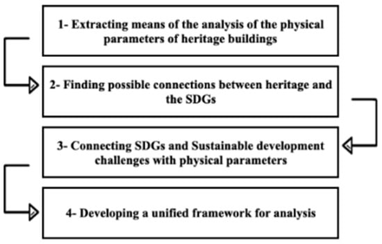
Figure 1.
Summary of research methodology.
3.1. Framework Proposed
This research builds on Hassan et al.’s [6] by using the six physical parameters they proposed as proxies for the potential social, economic, and cultural activities on the street. The authors further break down the six parameters into elements to systematize the analysis further. The proposed breakdown is as follows:
- Complexity and architectural character are studied in terms of (1) ornamentation (types and frequency of occurrence) and (2) shapes (diversity and frequency of occurrence);
- Permeability is studied in terms of opening (types and number, and the existence of depth behind openings or lack thereof);
- Territoriality and personalization are studied in terms of the interventions made (i.e., technique diversity, compatibility with the façade, and discretion);
- Enclosure is studied in terms of (1) the enclosure ratio (between buildings and the street width) and (2) the occurrence of trees (as soft barriers to enhance the enclosure ratio);
- Ground-floor use is studied in terms of the occurrence of the most popular functions;
- Physical comfort is studied in terms of (1) environmental comfort (shading and greenery) and (2) seating options (with regards to diversity, safety, and quality).
Beyond the simple study of existing connections and links between the SDGs and the built environment, such as those presented in Table 1, it is essential to integrate the 2030 Agenda into new analytical frameworks that can be used to analyze the built environment more holistically, with the intent to utilize the full transformative potential of the SDGs [45]. While contradictions and trade-offs between the agenda’s targets and goals have been reported [21,23,46,47,48,49,50], analysis frameworks for buildings and the built environment should consider the connections between observable parameters and the SDGs while leaving the direction of these connections to the specific case of application. In applying the analysis frameworks, critical judgment becomes key in determining the strength and direction of connection between different parameters and the SDGs [51].
The synergetic versus trade-off analogy is taken from a previously studied framework that established a way to study the correlations between energy and the SDGs [52]. After cross-examining the SDG links and the built heritage with the physical parameters identified above, it was noted that all the relationships found were synergetic. Thus, the proposed framework draws connections between the six physical parameters of heritage façades and the SDGs based on available research. Table 2 presents the relation between the SDGs and their targets, with the physical parameters identified above, and includes brief reasoning of synergy based on sources shown in Table 1.
Table 2.
Relations between SDGs and the physical parameters of heritage sites.
Through the links drawn and presented in Table 2, we produce a general framework and analysis process, illustrated in Figure 2. In this framework, the six proposed parameters, which tie activity levels to the built environment and heritage attributes, are directly connected with sustainable development challenges. The outcome is a new analytical framework that can be used to now study the contribution of built heritage to the SDGs.
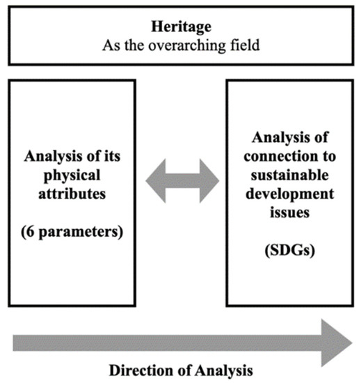
Figure 2.
Analysis framework and process proposed.
3.2. Analysis Procedure
The research focuses on the area of El Korba, Heliopolis, in Cairo. As illustrated in Figure 2, and following the proposed analysis process, the physical parameters of the façades are assessed to extract their effects on their correlated SDGs, based on the connections presented in Table 2. Two analyses are conducted:
- (1)
- In the first analysis, we evaluate the current condition of the area based on site visits conducted in the years 2021 and 2022 (documented in photos).
- (2)
- In the second, we compare the current state to the area’s original condition based on images taken in the early 1900s. This second analysis aims to extract the patterns of deterioration and their consequences on the continued contribution of El Korba to SDGs.
In the analysis, which is mainly presented visually in the article, specific locations in case study figures have been enlarged and labeled separately with a numbering system based on the relevant parameter (referring to the list presented in Section 3.1). For example, P1.1 indicates that this is the first relevant enlargement for parameter 1, P1.2 indicates the second relevant enlargement for parameter 1, and so on. These enlarged points in the diagram are then referred to in the analysis text and tables as evidence of the presence of the respective parameters.
3.3. Case Study Description: El Korba, Heliopolis, Cairo (Egypt)
As Figure 3 shows, Heliopolis was initially designed in 1906 as two “oases” that were to be connected by a big avenue. The first oasis (where El Korba is now) was a residential area for high-income residents, including foreigners, while the second oasis, much farther from Cairo, was designed to house lower-income groups [53]. Later, during the 1950s and 1960s, the old part of Heliopolis became its center, which is now known as El Korba. El Korba has continuously been recognized for its distinctive social life, stimulated by its unique architectural character, which is apparent in Figure 4. This is because El Korba has several exceptional urban design features and elaborate building façade designs that are not present in other locations in Cairo.
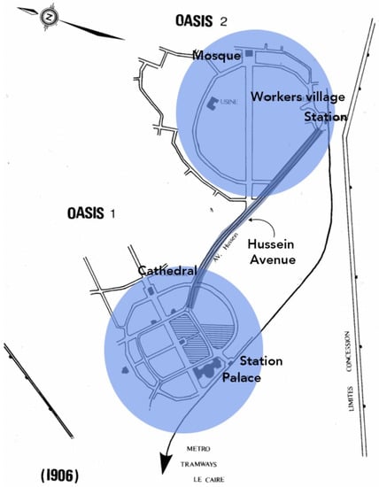
Figure 3.
Original Heliopolis Design in 1920 [54].
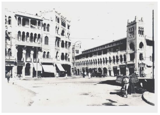
Figure 4.
Boulevard Ibrahim El-Lakkani. Top: 1920′s [55].
Later, specifically during the Infitah (globalization) era of the 1970s and 1980s, Heliopolis went through uncontrollable changes and expansions that resulted in shifts, and even deterioration, in the area’s urban character and façade designs [53], as could be seen from Figure 5. While El Korba continued to include many commercial and mixed-use functions, the newly developed buildings in the area were mainly residential [53]. As Figure 6 shows, despite losing some of its appeal, nowadays El Korba remains one of Cairo’s most popular social gathering places [55,56]. In her study [56], Caroline Nassif asked people about the public spaces they enjoyed being in the most, and among the first listings was El Korba. Another study by Muhammed Eldaidamony et al. [56] confirms this success in stimulating social activity by noting that the locations of commercial activities were mainly intense, either close to or inside Heliopolis’s maintained buildings as opposed to the newer buildings. With this, researchers agree that while the El Korba district is still one of the most diverse districts commercially and socially, it is in danger of actual deterioration due to the lack of consideration for the users’ needs in a planned and regulated way [55,56].
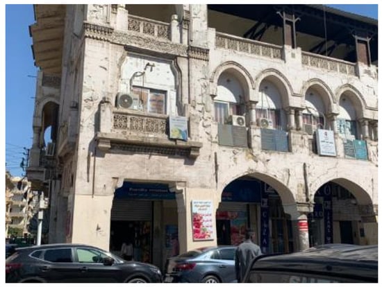
Figure 5.
Ibrahim Street (taken by authors, 2020).
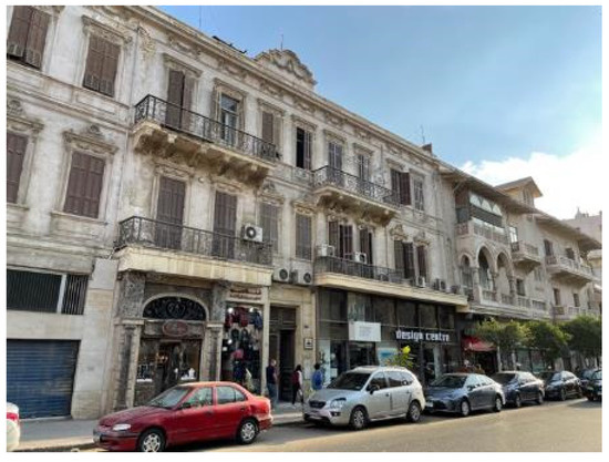
Figure 6.
Baghdad Street (taken by authors, 2021).
El Korba’s historical background is key to conducting a successful case study for testing the framework proposed in this study. Depending on the original images taken from El Korba after its construction in the early 1900s, the study can highlight how alterations and deterioration in the building façades have impacted its potential continued contribution to local sustainable development and the SDGs. Therefore, we will be stressing the effects of these façade alterations in the analysis and discussion. The changes include, but are not limited to: the addition of outdoor air-conditioning units following the proliferation of HVAC; the prominence of billboards, advertisements, and signs because of the infitah; and finally, the inclusion of diverse modern materials and eclectic colors that do not respect the local identity of the El Korba area [53].
To analyze the case studies, the researchers have conducted a series of site visits. The intent of these visits was to document façade features, street activities, study the relationship between the building features and the street activities (i.e., documenting how people interact with the building façades on the ground floor and upper floors), and to study the environmental characteristics of the façades (i.e., by visiting the locations at different times during the day). The research team recorded these observations using pictures, maps, and sketches, complemented with written notes. The research team also recorded visible deterioration in the façades and their features, as well as alterations or changes made to the façade which were visible from the street. To transfer the knowledge gained by this site visit to the reader, the researchers selected some images and annotated them with the different features and information recorded. This approach helped condense information in a format that is easy to read. A series of photos from these visits is shown in Figure 7, Figure 8, Figure 9, Figure 10, Figure 11, Figure 12, Figure 13 and Figure 14 to give the reader a better understanding of the architectural character of the El Korba area.
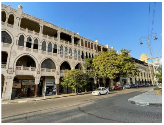
Figure 7.
Baghdad Street (taken by authors, 2021).
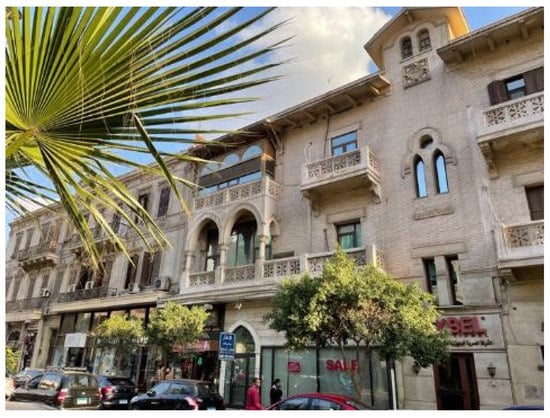
Figure 8.
Baghdad Street (taken by authors, 2021).

Figure 9.
Baghdad Street (taken by authors, 2021).
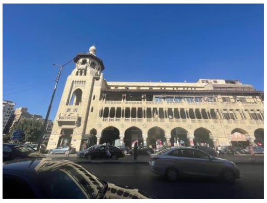
Figure 10.
Ibrahim El-Lakkani Street (taken by authors, 2021).
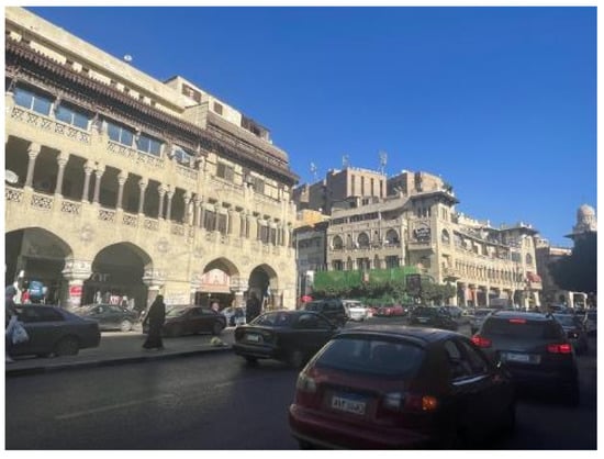
Figure 11.
Ibrahim El-Lakkani Street (taken by authors, 2021).
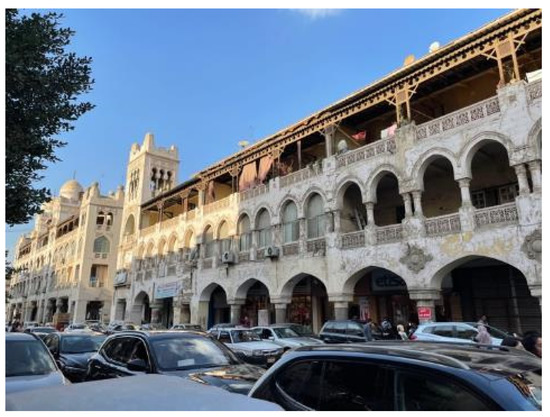
Figure 12.
Ibrahim Street (taken by authors, 2021).
Figure 13.
Al-Ahram Street (taken by authors, 2021).
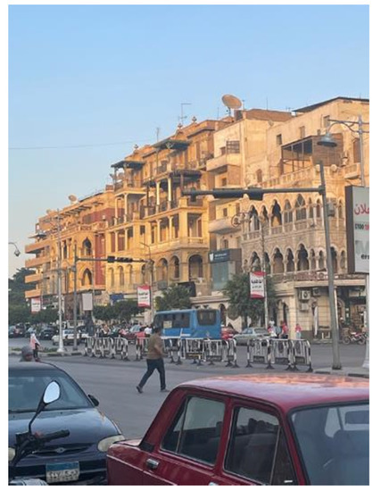
Figure 14.
Al-Ahram Street (taken by authors, 2021).
Depending primarily on visible inspection and observations posed some limitations. These include only recording the range of activities that happened during the visits, limiting the observations of façade features and their deterioration to those only visible from the street level, and only recording environmental characteristics that could be seen or sensed by the common space user. The researchers are aware that some of these limitations could have been avoided if more advanced sensing technologies were used. However, given that the aim of the article is studying how the building façades, a tangible dimension of heritage, facilitates intangible components of heritage, including sustainable development, the interest was to capture the user experience and perception of the façades. Thus, while a more advanced analysis could have revealed more features or insights, they would have exceeded the general user’s experience of the space. Furthermore, and while the images used in the paper do not capture the full details, they serve as a communication tool for the manuscript.
The analysis of the case studies from El Korba is broken down into three levels. The first is the street level analysis, which analyzes three streets in the El Korba area (Baghdad, Ibrahim El-Lakkani, and Al-Ahram Streets) with regards to the parameters present in each street. The second level is the building level analysis, where certain buildings were chosen from each of the streets to be examined further. Lastly, the third level is the comparison analysis between the original design of Baghdad Street and its current state. For this, we depend on available images retrieved from archives.
The images of each of the streets, buildings, as well as the comparison images, are annotated by marking (in the reference images) the certain elements that highlight the presence of each parameter, respectively. Then, after each reference image in each of the levels, the elements for each parameter in that level is zoomed in for a closer analysis. This analysis is presented in a table that summarizes the details of each of the marked elements and the SDGs that are consequently present, based on the framework. Afterwards, a written summary discusses the reasoning for the presence of each element. At the end of each level (street, building, and comparison) there is a brief discussion of the most prominent SDGs that are present in each of the levels. Figure 15 presents this structure more clearly.
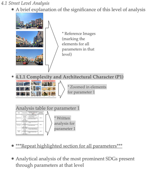
Figure 15.
Clarification diagram of the structure for the case studies section. (* description, ***__*** process).
4. Case Studies from El Korba
4.1. Street Level Analysis
Firstly, an analysis is provided for three prominent streets in the area: Baghdad, Ibrahim El-Lakkani, and Al-Ahram Streets. The analysis is presented visually in Figure 16, Figure 17, Figure 18, Figure 19, Figure 20, Figure 21, Figure 22, Figure 23 and Figure 24, which highlight the occurrence of the six parameters, and Table 3, Table 4, Table 5, Table 6, Table 7 and Table 8, which discuss the elements for each parameter marked and the SDGs present according to the methodological framework presented earlier in this research.
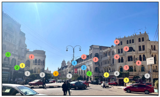
Figure 16.
Reference image for the elements present in each parameter on Baghdad Street in El Korba area. The photos were taken and annotated by the authors. (Annotation Explanation: numbers in the following-colored bubbles indicate the number of the element detected for each of the respective parameters: pink bubbles = P1 Complexity and Architectural Character; blue bubbles = P2 Permeability; green bubbles = P3 Territoriality and Personalization; orange bubbles = P4 Enclosure; yellow bubbles = P5 Ground Floor Use; and gray = P6 Physical Comfort).
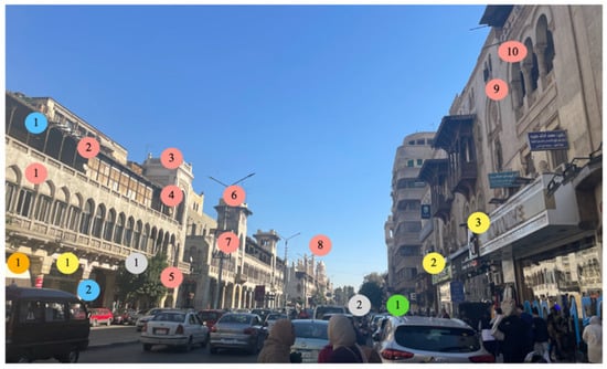
Figure 17.
Reference image for the elements present in each parameter on Ibrahim El-Lakkani Street in the El Korba area (courtesy of Sherif Abou El Gadayel, 2021; annotated by author). (Annotation Explanation: numbers in the following-colored bubbles indicate the number of the element detected for each of the respective parameters: pink bubbles = P1 Complexity and Architectural Character; blue bubbles = P2 Permeability; green bubbles = P3 Territoriality and Personalization; orange bubbles = P4 Enclosure; yellow bubbles = P5 Ground Floor Use; and gray = P6 Physical Comfort).
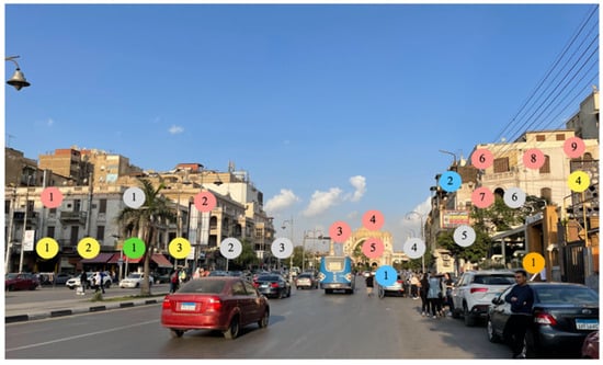
Figure 18.
Reference image for the elements present in each parameter on Al-Ahram Street in the El Korba area (photos taken and annotated by the authors). (Annotation Explanation: numbers in the following-colored bubbles indicate the number of the element detected for each of the respective parameters: pink bubbles = P1 Complexity and Architectural Character; blue bubbles = P2 Permeability; green bubbles = P3 Territoriality and Personalization; orange bubbles = P4 Enclosure; yellow bubbles = P5 Ground Floor Use; and gray = P6 Physical Comfort).
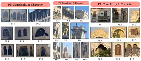
Figure 19.
Complexity and architectural character (P1) elements present on Baghdad Street (left), Ibrahim El-Lakkani Street (middle), and Al-Ahram Street (right). The photos were taken and annotated by the authors.
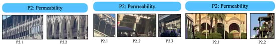
Figure 20.
Permeability (P2) elements present on Baghdad Street (left), Ibrahim El-Lakkani Street (middle), and Al-Ahram Street (right). The photos were taken and annotated by the authors.
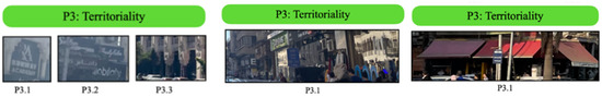
Figure 21.
Territoriality and personalization (P3) elements present on Baghdad Street (left), Ibrahim El-Lakkani Street (middle), and Al-Ahram Street (right). The photos were taken and annotated by the authors.
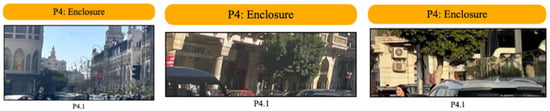
Figure 22.
Enclosure (P4) elements present on Baghdad Street (left), Ibrahim El-Lakkani Street (middle), and Al-Ahram Street (right). The photos were taken and annotated by the authors.
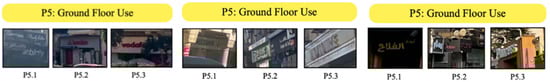
Figure 23.
Ground-floor use (P5) elements present on Baghdad Street (left), Ibrahim El-Lakkani Street (middle), and Al-Ahram Street (right). The photos were taken and annotated by the authors.
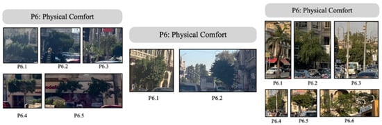
Figure 24.
Physical comfort (P6) elements present on Baghdad Street (left), Ibrahim El-Lakkani Street (middle), and Al-Ahram Street (right). The photos were taken and annotated by the authors.
Table 3.
Summary for Complexity and Architectural Character in Street-level Analysis.
Table 4.
Summary for Permeability in Street-Level Analysis.
Table 5.
Summary for Territoriality and Personalization in Street-Level Analysis.
Table 6.
Summary for Enclosure in Street-Level Analysis.
Table 7.
Summary for Ground-Floor Use in Street-Level Analysis.
Table 8.
Summary for Physical Comfort in Street-Level Analysis.
4.1.1. Complexity and Architectural Character (P1)
Ornamentations (types and frequency): There is a great diversity in ornamentations as seen in the case studies. In Baghdad Street (Figure 16), stucco decorations can be seen in P1.5 in the spandrels of the arch, as well as the decorations in the balcony’s parapet. Furthermore, in P1.8, similar stucco decorations are found in the spandrels of the arch. In Ibrahim El-Lakkani Street (Figure 17), ornamentations can be found in the parapet of the tower in P1.3, and in P1.4, stucco ornamentation is found in the spandrels of the arch. There is also an intricate wooden canopy around one of the towers, as seen in P1.6. In Al-Ahram Street (Figure 18), ornamentations can also be found in P1.3 in the windows below the church’s dome, and other similar windows can be found below the bigger dome in P1.4. Moreover, in P1.5, a decorative element is found around the main entrance’s arch. Lastly, in P1.7, a stucco medallion is found in the spandrel of the arch. These ornamentations also appear frequently throughout the building facades. Shapes (types and frequency): There is also a diversity of shapes that is apparent, as seen in Figure 2, Figure 3 and Figure 4. In Baghdad Street (Figure 16), for instance, there is a diverse range of arch shapes and sizes; there are: pointed (P1.1 and P1.3), triangular (P1.4), round trefoil (P1.5), pointed trefoil (P1.6 and P1.8), and flat arches (P1.7). There are also rectangular shapes for the windows in P1.2. In Ibrahim El-Lakkani Street (Figure 17), the present arch shapes are: Tudor (P1.1), flat (P1.2), round (P1.4 and P1.9), ogee 3-centered (P1.5), and pointed (P1.7), and a set of 3-round arches found in P1.10. Additionally, in P1.3, there are knob-shaped decorations in the paneled parapet wall of the tower.
In Al-Ahram Street (Figure 18), the arch shapes present are round (P1.2 and P1.5), 3-pointed (P1.7), round trefoil (P1.7), segmented (P1.8), and 3-centered (P1.9). There are also rectangles (P1.1), small round domes (P1.3), a bigger round dome (P1.4), and square windows (P1.6). The occurrence of different shapes in the street-level analysis of Baghdad and Ibrahim El Lakkani Streets is quite frequent; it is much less frequent, however, for Al-Ahram Street.
4.1.2. Permeability (P2)
Openings (types, frequency, and depth): Throughout all the streets there is an evident presence of permeability. In Baghdad Street (Figure 16), there is a frequent presence of a diverse range of openings such as windows, arches, as well as other openings for terraces.
In Ibrahim El-Lakkani Street (Figure 17), there is permeability, mainly through the presence of the arcade on the ground floor (P1.2) with glass storefronts for the users to see the goods on display inside, and through windows on the consecutive floors above (P2.3) until the roof (P2.1).
In Al-Ahram Street (Figure 18), there is permeability in the presence of an arcade at the entrance of the church (P2.1), and in the terrace openings such as those in P2.2. Overall, Al-Ahram Street shows the least permeability of the three case studies.
Unfortunately, many of the present openings in the three streets have been blocked by the users, thus removing the depth factor behind them, as will be explained in the third section of the results: Comparison Between Original and Current Design.
4.1.3. Territoriality and Personalization (P3)
Intervention (technique diversity, compatibility, size, and discretion): The main technique used to express territoriality and personalization is the use of signs for the stores in the streets. This can be seen in Baghdad Street (Figure 16) in P3.1 and P3.2, and Ibrahim El-Lakkani Street (Figure 17) in P3.1. In Al-Ahram street (Figure 18), however, another technique appears, which is the use of canopies to create a shared space underneath for users to interact within (P3.1). Moreover, in Ibrahim El-Lakkani Street (Figure 17), store owners use the technique of displaying their merchandise outdoors as a way of marking this part of the sidewalk as theirs and to attract walkers into their stores. The use of arcades is the last technique found (P3.3) in Baghdad Street (Figure 16); this technique also applies in Ibrahim El-Lakkani Street (Figure 17).
4.1.4. Enclosure (P4)
Enclosure ratio: The ratios of building height and street width for Ibrahim El-Lakkani Street and Baghdad Street (Figure 16) are quite good. The buildings on Ibrahim El-Lakkani Street (Figure 17) are 3-story buildings (including the enclosed roofs), making a height of around 11m, with attached towers that are around 14 m (which will serve as the total building height). This makes an enclosure ratio of 1:1.7, as the street width is 25 m. According to Alkhresheh’s research, this lies within the ideal range of enclosure [20]. The buildings on Baghdad Street (Figure 16) are 4-story buildings (including the enclosed roofs), making a height of around 14m, with attached towers that are around 17m (which will serve as the building’s total height). This makes an enclosure ratio of 1:1.4. This is so far the best ratio, and, according to Alkhresheh’s research, lies within the ideal range of enclosure [20].
Trees: The presence of trees near the buildings on all three streets helps reduce the usable street width, making the enclosure ratio better. This can be seen in the overall picture for all three streets in Figure 16, Figure 17 and Figure 18. The presence of trees also helps in another way. In Baghdad Street (Figure 16), the street is divided into two by a very thin island in the middle with planted trees. This cuts the ratio of 1:1.4 in half, making it 1:0.7. In some cases, this might be considered claustrophobic [20]; however, in this case, it is not for a few reasons. The first is that the barrier used to divide the street is a soft barrier (greenery) as opposed to solid barriers. The second is that it is a much shorter barrier than the surrounding building heights. Lastly, the barrier is not continuous, strictly speaking, because the trees are planted with about 1.5–2 m in between.
4.1.5. Ground-Floor Use (P5)
Popular spaces (functions and frequency): The ground-floor functions are quite successful in all three streets. For instance, on Baghdad Street (Figure 16), there are cafés (P5.2), furniture (P5.1), retail (P5.1), jewelry (P5.1), and phone carrier stores (P5.3). In Ibrahim El-Lakkani Street (Figure 17), there are banks (P5.1 and P5.2), shoe stores (P5.2), and retail stores (P5.3). Finally, on Al-Ahram Street (Figure 4), there are restaurants (P5.1 and P5.3) and retail stores (P5.2). All these successful functions are very frequent across the ground floors of the buildings on these streets.
4.1.6. Physical Comfort (P6)
Shading and greenery: The use of trees and shading devices is evident on all three streets. On Baghdad Street (Figure 16), there are many trees to provide shading near the buildings (P6.1, P6.2, P6.3, P6.4, and P6.5). There are also the arcades (overall picture) to provide shading for the users browsing the stores on the ground floor. This provides a comfortable atmosphere for users to interact with the buildings and be social without physical harm from the weather. On Ibrahim El-Lakkani Street (Figure 17), some trees also provide shading (P6.1 and P6.2). Finally, on Al-Ahram Street (Figure 18), there are trees that provide shading (P6.1, P6.2, P6.3, P6.4, P6.5, and P6.6).
Seating options (diversity, safety, and quality): There are several seating options on all three streets. Behind the arcades on Baghdad Street (Figure 16), there are often chairs in front of stores where store owners sit to contemplate the street and welcome people willing to come in. However, there is no seating outside the arcades for the lack of shading devices to protect these seats from the sun. On Ibrahim El-Lakkani Street (Figure 17), there is the same style of seating as on Baghdad Street (behind the arcades), and not on the street itself. On Al-Ahram Street (Figure 18), there are no arcades, but there is outdoor seating for the restaurants (P6.1), because they are protected from the sun by the big canopies that shade them.
As seen from the street-level analysis results, some SDG links stood out and were irrefutably corroborated using the case studies. Some parameters were more definitive in their connections with the proposed SDG links and required no further testing or evidence. Others are intuitively relevant but require further qualitative corroboration. To start, P1 (complexity and architectural character) is strongly linked with SDG 11 as it advances its targets related to safeguarding the world’s cultural heritage and creating sustainable human settlements. For P3 (territoriality and personalization), SDG 8 is evidently linked in 2 out of the 3 case studies as the personalized store signalization adds to the economic value of the street. SDG 8 is also linked to P5 (ground-floor use) effortlessly as it is a parameter that focuses on diverse economic functions, strengthening the SDG targets. P4 (enclosure) and P6 (physical comfort) are linked to SDG 13 in case studies where trees were present, adding to the methods of combating climate change.
4.2. Building-Level Analysis
Secondly, an analysis is provided for one distinct building in each of the chosen streets in the street-level analysis. These can be found in Figure 25, Figure 26, Figure 27, Figure 28, Figure 29, Figure 30, Figure 31, Figure 32 and Figure 33, which highlight the occurrence of the six parameters, and Table 9, Table 10, Table 11, Table 12, Table 13 and Table 14, which discuss the elements for each parameter marked and the SDGs present according to the methodological framework presented earlier in this research. Following this, a write-up discusses in more detail the analysis, and why each parameter was marked as present in these buildings’ designs.
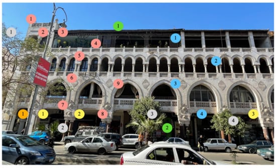
Figure 25.
Reference image for the elements present in each parameter on building on Baghdad Street (photos taken 2022 and annotated by the authors). (Annotation Explanation: numbers in the following-colored bubbles indicate the number of the element detected for each of the respective parameters: pink bubbles = P1 Complexity and Architectural Character; blue bubbles = P2 Permeability; green bubbles = P3 Territoriality and Personalization; orange bubbles = P4 Enclosure; yellow bubbles = P5 Ground Floor Use; and gray = P6 Physical Comfort).
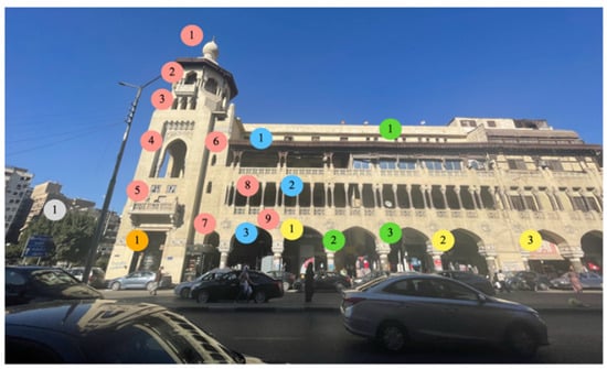
Figure 26.
Reference image for the elements present in each parameter on Heliopolis Company Building on Ibrahim El-Lakkani Street (photos taken 2022 and annotated by the authors). (Annotation Explanation: numbers in the following-colored bubbles indicate the number of the element detected for each of the respective parameters: pink bubbles = P1 Complexity and Architectural Character; blue bubbles = P2 Permeability; green bubbles = P3 Territoriality and Personalization; orange bubbles = P4 Enclosure; yellow bubbles = P5 Ground Floor Use; and gray = P6 Physical Comfort).
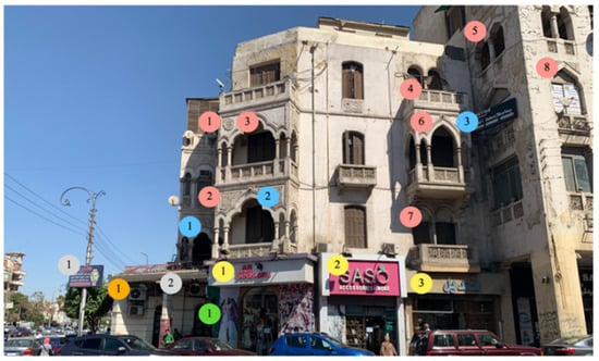
Figure 27.
Reference image for the elements present in each parameter on building on Al-Ahram Street (photos taken 2021 and annotated by the authors). (Annotation Explanation: numbers in the following-colored bubbles indicate the number of the element detected for each of the respective parameters: pink bubbles = P1 Complexity and Architectural Character; blue bubbles = P2 Permeability; green bubbles = P3 Territoriality and Personalization; orange bubbles = P4 Enclosure; yellow bubbles = P5 Ground Floor Use; and gray = P6 Physical Comfort).
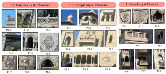
Figure 28.
Complexity and architectural character (P1) elements present on Baghdad Street (left), Ibrahim El-Lakkani Street (middle), and Al-Ahram Street (right). The photos were taken and annotated by the authors.
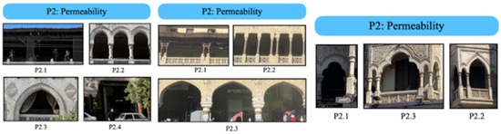
Figure 29.
Permeability (P2) elements present on Baghdad Street (left), Ibrahim El-Lakkani Street (middle), and Al-Ahram Street (right). The photos were taken and annotated by the authors.
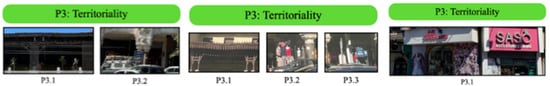
Figure 30.
Territoriality and personalization (P3) elements present on Baghdad Street (left), Ibrahim El-Lakkani Street (middle), and Al-Ahram Street (right). The photos were taken and annotated by the authors.
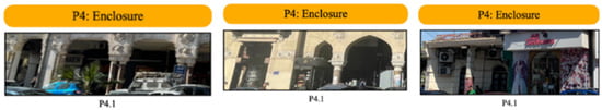
Figure 31.
Enclosure (P4) elements present on Baghdad Street (left), Ibrahim El-Lakkani Street (middle), and Al-Ahram Street (right). The photos were taken and annotated by the authors.
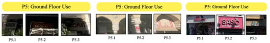
Figure 32.
Ground-floor use (P5) elements present in Baghdad Street (Left), Ibrahim El-Lakkani Street (Middle), and Al-Ahram Street (Right). The photos were taken and annotated by the authors.
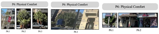
Figure 33.
Physical comfort (P6) elements present in Baghdad Street (Left), Ibrahim El-Lakkani Street (Middle), and Al-Ahram Street (Right). The photos were taken and annotated by the authors.
Table 9.
Summary for Complexity and Architectural Character in Building-Level Analysis.
Table 10.
Summary for Permeability in Building-Level Analysis.
Table 11.
Summary for Territoriality and Personalization in Building-Level Analysis.
Table 12.
Summary for Enclosure in Building-Level Analysis.
Table 13.
Summary for Ground-Floor Use in Building-Level Analysis.
Table 14.
Summary for Physical Comfort in Building-Level Analysis.
4.2.1. Complexity and Architectural Character (P1)
Ornamentations (types and frequency): On the building level, the intricate ornamentations appear more clearly up close, in the different stucco designs on the façade features. For instance, on the building on Baghdad Street (Figure 25), there are stucco ornamentations on the paneled parapet wall in P1.1, another ornamentation design for the parapet in P1.3, and more stucco ornamentations on the building’s facade in P1.6, P1.7, and P1.8.
On the building on Ibrahim El-Lakkani Street (Figure 26), there is ornamentation on the wooden shading device in P1.1. There are also other ornamentation designs below balconies (P1.3), above arches (P1.4), on parapets (P1.5), and on the façade itself in the form of stucco medallions (P1.9).
On the building on Al-Ahram Street (Figure 27), there are ornamentations in the form of various stucco designs on the spandrels of arches (P1.1, P1.2, P1.3, and P1.8), on parapet designs (P1.4, P1.6, and P1.7), and in the form of medallions (P1.1 and P1.3).
Shapes (types and frequency): There is an even greater diversity in shapes that appears up close in the different façade features. On the building on Baghdad Street (Figure 25), there are different parapet shapes (P1.1, P1.3, and P1.9) and different types of arches including draped (P1.2), flat (P1.4), and 3-pointed (P1.5).
On the building on Ibrahim El-Lakkani Street (Figure 6), the shapes that appear are many as well. There is an onion dome (P1.1), a horizontal wooden shading device with a unique shape of crenellations (P1.2), and several arch shapes that include triangular (P1.6), 4-centered (P1.7), and flat (P1.8).
On the building on Al-Ahram Street (Figure 27) there is a very interesting phenomenon that appears, which is the combination of several arch shapes in one. This can be seen in P1.5 and P1.8 where the arches combine between the triangular arch and the shouldered arch. There are also round trefoil arches (P1.3), 3-pointed arches (P1.6), and round arches (P1.7) for the different balconies of the building.
4.2.2. Permeability (P2)
Openings (types, frequency, and depth): Frequent permeability is met in all three buildings with windows, arcades, balconies, and terraces. On the building on Baghdad Street (Figure 25), there are terrace openings on the roof (P2.1), arched terrace openings in P2.2 and P2.3, and an arcade on the ground floor (P2.4).
On the buildings on Ibrahim El-Lakkani Street (Figure 6) and Al-Ahram Street (Figure 27), permeability is met mainly with terrace openings. In Figure 5, there are terrace openings on all floors (P2.1 and P2.2) and an arcade on the ground floor (P2.3). Moreover, in Figure 6, there are terrace and balcony openings on all floors (P2.1, P2.2, and P2.3).
There is, however, a problem with the depth behind these openings, as many are blocked, as can be seen in the overall picture in Figure 4 of the building on Baghdad Street, on the first floor. This can also be seen in the overall picture in Figure 5 of the building on Ibrahim El-Lakkani Street, on the second floor.
4.2.3. Territoriality and Personalization (P3)
Intervention (technique diversity, compatibility, size, and discretion): There are several techniques used to create territoriality and personalization that appear in the building-level analysis that were not apparent in the street-level analysis. For example, on the building on Baghdad Street (Figure 25), there appear to be plants growing on the roof (P3.1). This indicates that someone tends to them regularly, subtly marking this zone as theirs. Moreover, the arcade on the ground floor (P3.2) allows the store owners to express territoriality and personalization without compromising the façade’s character, as will be seen in the other cases.
On the building on Ibrahim EL-Lakkani Street (Figure 26), there is territoriality in the use of shading canopies (P3.1) to allow owners of this space to mark it as belonging to their territory. On the ground floor, there is also an outdoor display of goods (P3.2), which is a very strong way to mark territory and express personalization or identity, but it compromises the character of the building, as seen from the sidewalk. Finally, there are store signs (P3.3), which is the most popular technique of expressing personalization but also harms the character of the building.
On the building on Al-Ahram Street (Figure 27), the main expression of territoriality and personalization is through the huge store signs on the building’s ground floor façade (P3.1), which completely ruins the building’s character.
4.2.4. Enclosure (P4)
Enclosure ratio: On the building level, the enclosure is met mainly with arcades on the ground floors of the buildings. This is the case for the buildings on Baghdad and Ibrahim El-Lakkani Streets (Figure 25 and Figure 26, respectively). Considering an approximate height of 4 m for the ground floors of these buildings, and an approximate width of 3 m between the storefronts and the arcade, the enclosure ratio would be around 1:1.3. This is within the ideal range according to Alkhresheh’s research [20]. It can be seen on the building on Baghdad Street (Figure 25) in P4.1 and on the building on Ibrahim El-Lakkani Street (Figure 26) in P4.1. As for the building on Al-Ahram Street (Figure 27), the only weak sign of enclosure is in the recessed zone on the ground floor in P4.1, for which there is not a strict enclosure ratio that could be calculated.
Trees: The presence of trees near the buildings helps with increasing the sense of enclosure, especially for the buildings on Baghdad and Ibrahim El-Lakkani Streets (Figure 25 and Figure 26, respectively), where they are placed near the arcades, enhancing the sense of enclosure as perceived from inside the arcades.
4.2.5. Ground-Floor Use (P5)
Popular spaces (functions and frequency): There is a frequent occurrence of needed functions on the ground floors of buildings on all three streets, which enhances the interaction levels on the sidewalks and near the buildings. In the building on Baghdad Street (Figure 25), for example, there are several needed store functions (P5.1, P5.2, and P5.3). Moreover, in the building on Ibrahim El-Lakkani Street (Figure 26), there are retail (P5.1) and jewelry shops (P5.2), as well as restaurants (P5.3). In the building on Al-Ahram Street (Figure 27), there are also retail shops (P5.1) and jewelry shops (P5.2).
4.2.6. Physical Comfort (P6)
Shading and greenery: There are several aspects of shading and greenery that can be seen and experienced on all three streets. By the building on Baghdad Street (Figure 25), the use of trees provides physical comfort through shading for the users. Added with the arcade on the ground floor, which provides strong shading, this allows them to interact freely with the building’s ground-floor functions. This can be seen in P6.1, P6.2, and P6.3.
By the buildings on Ibrahim El-Lakkani and Al-Ahram Streets (Figure 25 and Figure 26, respectively), there is one tree (Figure 26, P6.1, and Figure 27, P6.1) that provides shading, but there are not enough trees across the buildings’ sidewalks. However, by the building on Ibrahim El-Lakkani Street (Figure 26), the arcade (overall picture) provides strong and sufficient shading, and in the building on Al-Ahram Street (Figure 27), the recessed zone (P6.2) provides some shade for the users in that zone.
Seating options (diversity, safety, and quality): The seating options on the building level are lacking for all three streets. Behind the arcades of the buildings on Baghdad and Ibrahim El-Lakkani Streets (Figure 25 and Figure 26, respectively), there are occasional chairs for shop owners, but other than that, there are not many outdoor seating options for the buildings chosen for the case studies, for lack of safety in any other zone besides inside the arcades.
There were also SDGs in the building-level analysis that were evidently linked to the physical parameters through the case studies. For instance, P1 (complexity and architectural character) is directly aiding in SDG 11 by affecting the status of preservation of world cultural heritage. As for P3 (territoriality and personalization), it is affecting SDG 8 through the driving of economic activity through personalized store frontages. In addition, P5 (ground-floor use) is naturally linked to SDG 8 due to the economic nature of the parameter in the context analyzed. Finally, P6 (physical comfort) is linked to SDG 13 due to the presence of trees in the context of the case studies.
4.3. Comparison Analysis
Lastly, we compare Baghdad Street’s original and current design as a third and final analysis. This analysis aims to prove that the historical attributes of the design in this area give it the potential to achieve sustainable goals. In this analysis, the performance of the parameters will be assessed in a comparison table to see the effect of their change in the respective SDGs that each parameter corresponds to.
These can be found in Figure 34, Figure 35, Figure 36, Figure 37, Figure 38, Figure 39, Figure 40 and Figure 41, which highlight the occurrence of the six parameters, and Table 3, Table 4, Table 5, Table 6, Table 7, Table 8, Table 9, Table 10, Table 11, Table 12, Table 13, Table 14, Table 15, Table 16, Table 17, Table 18, Table 19 and Table 20 discuss the elements for each parameter marked and the SDGs present according to the methodological framework presented earlier in this research. Following this, a write-up will discuss the analysis in more detail and why each parameter was marked as present in these buildings’ designs.
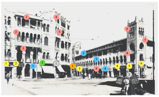
Figure 34.
Reference image for the elements present in each parameter at the junction between Baghdad and Ibrahim Street in El Korba area in the 1920s [57] (annotated by authors). (Annotation Explanation: numbers in the following-colored bubbles indicate the number of the element detected for each of the respective parameters: pink bubbles = P1 Complexity and Architectural Character; blue bubbles = P2 Permeability; green bubbles = P3 Territoriality and Personalization; orange bubbles = P4 Enclosure; yellow bubbles = P5 Ground Floor Use; and gray = P6 Physical Comfort).
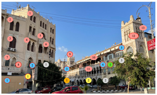
Figure 35.
Reference image for the elements present in each parameter at the junction between Baghdad and Ibrahim Street in El Korba area (Photo taken 2021 and annotated by authors). (Annotation Explanation: numbers in the following-colored bubbles indicate the number of the element detected for each of the respective parameters: pink bubbles = P1 Complexity and Architectural Character; blue bubbles = P2 Permeability; green bubbles = P3 Territoriality and Personalization; orange bubbles = P4 Enclosure; yellow bubbles = P5 Ground Floor Use; and gray = P6 Physical Comfort. And bubbles outlined in red are elements that indicate a decrease in the respective parameter).
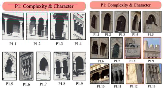
Figure 36.
Complexity and architectural character (P1) elements present on Baghdad Street (left), Ibrahim El-Lakkani Street (middle), and Al-Ahram Street (right). The photos were taken and annotated by the authors. (Annotation Explanation: Elements outlined in red are elements that indicate a decrease in the respective parameter).
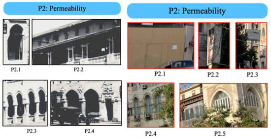
Figure 37.
Permeability (P2) elements present on Baghdad Street (left), Ibrahim El-Lakkani Street (middle), and Al-Ahram Street (right). The photos were taken and annotated by the authors. (Annotation Explanation: Elements outlined in red are elements that indicate a decrease in the respective parameter).
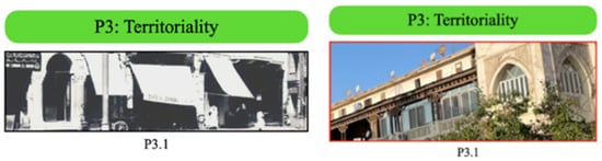
Figure 38.
Territoriality and personalization (P3) elements present on Baghdad Street (left), Ibrahim El-Lakkani Street (middle), and Al-Ahram Street (right). The photos were taken and annotated by the authors. (Annotation Explanation: Elements outlined in red are elements that indicate a decrease in the respective parameter).
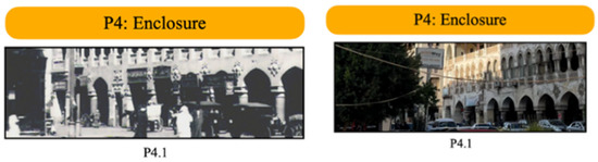
Figure 39.
Enclosure (P4) elements present on Baghdad Street in El Korba area The photos were taken and annotated by the authors.
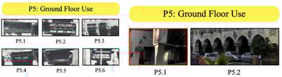
Figure 40.
Ground-floor use (P5) elements present on Baghdad Street in El Korba area The photos were taken and annotated by the authors. (Annotation Explanation: Elements outlined in red are elements that indicate a decrease in the respective parameter).
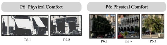
Figure 41.
Physical comfort (P6) elements present on Baghdad Street in El Korba area The photos were taken and annotated by the authors.
Table 15.
Summary for Complexity and Architectural Character in Comparison Analysis.
Table 16.
Summary for Permeability in Comparison Analysis.
Table 17.
Summary for Territoriality and Personalization in Comparison Analysis.
Table 18.
Summary for Enclosure in Comparison Analysis.
Table 19.
Summary for Ground-Floor Use in Comparison Analysis.
Table 20.
Summary for Physical Comfort in Comparison Analysis.
4.3.1. Complexity and Architectural Character (P1)
Ornamentations (types and frequency): In comparison with the original design (Figure 34), the faults of the current design (or state) of the buildings appear more clearly. For example, in the current design (Figure 35), the effects of the passing of time and environmental factors clearly appear in the deterioration of the paint and even plaster in some cases (P1.8, P1.11, and P1.12), and in the destruction of some parts, as can be seen in P1.5, where the ornamentation on top of the tower is partially destroyed. In the original design, however, the ornamentations appear much more clearly, and the design is complete with no missing or destroyed pieces.
Shapes (types and frequency): The shapes do not appear to have suffered much change or deterioration over the years. In the original design (Figure 34), there are several arch shapes that include flat (P1.1), 3-pointed (P1.2, P1.7, P1.8, and P1.9), keyhole (P1.3), pointed trefoil (P1.5), and a set of three 3-pointed arches (P1.4) and three keyhole arches (P1.6).
In the current design (Figure 9), we see the same diversity in and frequency of shapes. There are several arch shapes that include triangular (P1.1 and P1.7), 3-pointed (P1.2, P1.3, P1.4, and P1.11), and round trefoil (P1.5), flat (P1.6 and P1.10), and a set of three keyhole arches (P1.13).
4.3.2. Permeability (P2)
Openings (types, frequency, and depth): There has been deterioration in this parameter as well, because of the lack of both physical and visual permeability. In the original design (Figure 34), permeability is evident via the use of several opening types that include terrace balconies (P2.1), terrace openings (P2.2), and arcades (P2.3). All these features in the façade design allowed for physical permeability and visual permeability. This cannot, however, be said for the current design (Figure 35). In P2.1, there is a wooden board that blocks access to the street users of that zone of the building’s ground floor. Another phenomenon also appears that blocks visual permeability, which is advertisements; this can be seen in P2.2 and P2.3. In P2.4 and P2.5 is the last and most common reason of decreased permeability in the current design: blocked terrace openings. Users have been blocking many of the terrace openings in these buildings (whether residential or not) to create more space inside. This deletes the zone between the opening and the actual façade on the upper floors of the buildings, which dramatically decreases visual permeability and harms the building’s architectural character.
4.3.3. Territoriality and Personalization (P3)
Intervention (technique diversity, compatibility, size, and discretion): There Intervention (technique diversity, compatibility, size, and discretion): The parameter of territoriality has also been harmed, or more accurately misused, over the years. In the original design (Figure 34), besides the use of arcades to provide flexibility for users to express territoriality and personalization without harming the building’s architectural character, there is also the use of canopies to mark the space to which the canopy extends as theirs. Because these canopies are simple and are not vibrant or distracting, they do not compromise the building’s architectural character. In the current design (Figure 35), however, territoriality is expressed forcibly in the enclosure of spaces and blockage of openings. This is not only a forceful manner to express territoriality, but it also compromises the building’s architectural character.
The parameter of territoriality has also been harmed, or more accurately, misused, over the years. In the original design (Figure 34), besides the use of arcades to provide flexibility for users to express territoriality and personalization without harming the building’s architectural character, there is also the use of canopies to mark the space to which the canopy extends to as theirs. Because these canopies are simple and are not vibrant or distracting, they do not compromise the building’s architectural character. In the current design, however (Figure 35), territoriality is expressed forcibly in the enclosure of spaces and blockage of openings. This is not only a forceful manner to express territoriality, but it also compromises the building’s architectural character.
4.3.4. Enclosure (P4)
Enclosure Ratio: The enclosure ratio has not changed much between the original design in Figure 34 and the current design in Figure 35. The only change that indirectly contributes to the enclosure is the increase in vehicles in the street, whereas before it was a tramway and the street was used mostly on foot. However, the enclosure behind the arcades has not changed at all.
Trees: The presence of trees has increased over the years. More trees have been planted near buildings to enhance the sense of enclosure on the sidewalks by the buildings.
The enclosure ratio has not changed much between the original design in Figure 34 and the current design in Figure 35. The only change that indirectly contributes to the enclosure is the increase in vehicles in the street, whereas before, it was a tramway, and the street was used mostly on foot. However, the enclosure behind the arcades has not changed at all.
4.3.5. Ground-Floor Use (P5)
4.3.6. Physical Comfort (P6)
Shading and greenery: The presence of shading and greenery has not changed over the years. As in Figure 34 of the original design, there were arcades (P6.2) and canopies (P6.1) that provided shade. Moreover, in the current design (Figure 35), there are still the arcades (P6.2), and though there are no canopies, there are trees (P6.1 and P6.3) that provide shade as well.
Seating options (diversity, safety, and quality): The seating options have not changed over the years between the original design (Figure 34) and the current design (Figure 35).
Comparatively analyzing the streets allowed us to not only identify which SDGs were corroborated by the case studies, but which were also enhanced or deteriorated based on the case studies’ selected parameters. The results were as follows:
- The deterioration of the ornamentations in P1 (complexity and architectural character) negatively affects SDG 11 by slowing down its advancement. In turn, preserving such elements will aid in advancing said SDG and should be encouraged.
- The deterioration in elements of P3 (territoriality and personalization) slows down the progress of SDG 8 related to economic activity. Thus, the encouragement of self-expression and unique store identities should be maintained for the progression of SDG 8.
- The increase in trees in P4 (enclosure) aids in the progression of SDG 13 and should be further encouraged.
Other SDGs discussed in previous sections, which were proven to be effective, were unaffected by time through our case studies and analysis in this specific context.
5. Discussion and Conclusions
The analysis of the different streets and buildings, and the comparison between the original and current conditions of the area, all produced a unique set of results by which parameters were studied and linked to the possible SDGs they affect. The results of this research point to several specific parameters that have a more significant impact than others on the SDGs and, therefore, on the 2030 Agenda. For instance, it came through the analysis of the case studies that the first parameter (complexity and architectural character) has the most impact on the SDGs. Having a strong local architectural identity that is unique and original helps all of the following SDGs: good health and wellbeing (SDG 3) [35], decent work and economic growth (SDG 8) [40,41,42], sustainable cities and communities (SDG 11) [15,43], and finally, climate action (SDG 13) [15,44]. This points directly to the fact that the historical aspect of the buildings primarily drives their contribution to the achievement of local sustainability. This stems from the multiple roles these elements play in promoting the SDGs through different benefits, including through sustainable building materials, combating environmental problems, enhancing tourism, enhancing cultural value, promoting wellness and health, and many more. Unlike the other parameters with urban dimensions, the complexity and architectural character parameter focuses first and foremost on the buildings’ historic design. This explains why, in the comparison study done between the original and current conditions of El Korba, so many SDGs were only affected due to the deterioration of the ornamentations over the years.
Likewise, when enhanced or deteriorated, all other parameters positively or negatively impacted their corresponding SDGs (based on the framework). For example, the deterioration of permeability caused deterioration in SDG 3 (good health and wellbeing) [35] and SDG 5 (gender equality) [37,38,39], and the deterioration in territoriality and personalization caused a deterioration in SDG 4 (quality education) [36] and SDG 8 (decent work and economic growth) [40,41,42]. At the same time, the enhancement in enclosure caused an enhancement in SDG 5 (gender equality) [37,38,39].
The results also highlighted the multi-faceted and interlinked connections between heritage locations and the SDGs. Thus, while SDG 11 (target 11.4) is the only time the preservation of WHS is clearly stated in the UN’s 2030 Agenda, the preservation of heritage sites can contribute to a larger array of goals and targets. Based on the framework and analysis, SDGs 5 and 8 were the most likely to be further enhanced by preserving historical buildings and environments such as those in El Korba. This is because they are linked to 3 parameters each, making them essential focal points for this study. The synergetic links between SDG 5 and permeability, enclosure, and ground-floor use demonstrate the multiple ways in which gender-related issues may be addressed in the context of El Korba district. Similarly, SDG 8 was linked to complexity and architectural character, territoriality, personalization, and ground-floor use. This synergetic demonstration stresses the importance of an economically driven context and the multiple ways in which that can be achieved. This importance stems from an interlinkage of the above parameters, which give rise to a thriving touristic destination, a key economic activity in heritage-built environments.
Finally, the findings demonstrated how SDG 13 could be achieved in different ways. Combating climate change is one of the main challenges facing humanity. It is essential to note that heritage sites’ effects on combating climate change takes different forms, including preserving and promoting sustainable practices, locally sourced materials, vernacular approaches, methods of living, and preserving trees and greenery. This goes to demonstrate the importance of the preservation of such sites for their environmental benefits. In Figure 42, a summary of the framework of connections is presented which highlights the connections found and supported by previous literature, as well as the connections that were validated and substantiated by the analyses conducted in the case studies.
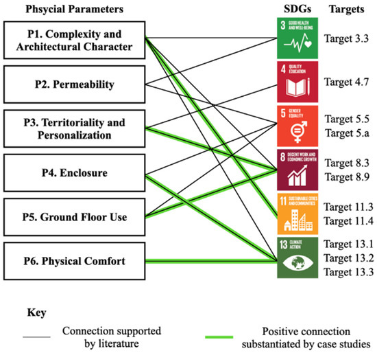
Figure 42.
Summary of the framework connections.
Limitations and Future Research Recommendations
One of the main limitations of this research is the fact that the investigations were based mainly on human inspection from the site. This subjects the findings from the case studies to several possible types of errors, some of which could be the limited angles of the camera, the lack of precise perception of distance from the photos, and simple errors of the human eye. Therefore, a recommendation for future research could be to address these issues by making use of the recent advancements in certain programs that allow for more accurate computer-vision-based building inspection.
Furthermore, based on the presented summary in Figure 42 above, there are a few different directions for recommendations for future research. The first recommendation stems from the consideration that not all the sustainability dimensions were directly addressed in the six chosen parameters. Since the scope of this research was to draw connections between the SDGs and already-existing parameters from previous research, a possible recommendation for future research could be to follow the same logic used in this paper to come up with more physical parameters that have an impact on the SDGs. Another direction for future research recommendations is finding more SDGs that connect with the built environment.
Finally, all the substantiated connections in summary have a positive correlation with the SDGs, because the parameters chosen were all parameters that have a positive impact on the SDGs. However, based on previous research in this field [21,23,46,47,48,49,50,52], it could be reasonably claimed that the parameters also negatively correlate with the SDGs. Studying those as well would be very helpful in avoiding harmful design practices. Therefore, future researchers could study more case studies to substantiate and identify the direction of the correlation for more connections, either from the framework presented in this research or from more parameters and SDG connections found.
Author Contributions
Conceptualization, S.G. and V.B.; methodology, V.B. and S.G.; formal analysis, V.B. and T.A.; investigation, V.B. and T.A.; resources, S.G., T.A. and V.B.; writing—original draft preparation, S.G., V.B. and T.A.; writing—review and editing, S.G. and V.B.; visualization, V.B.; supervision, S.G.; project administration, V.B.; funding acquisition, S.G. All authors have read and agreed to the published version of the manuscript.
Funding
The authors would like to acknowledge the support provided by the American University in Cairo.
Data Availability Statement
Not applicable.
Acknowledgments
The authors would like to thank the office of the Associate Provost for Research, Innovation and Creativity for funding the funding received to complete this work and for funding the APC for this study. The authors would also like to thank and acknowledge the excellent assistance of Laila El Refaie.
Conflicts of Interest
The authors declare no conflict of interest. The funders had no role in the design of the study; in the collection, analyses, or interpretation of data; in the writing of the manuscript, or in the decision to publish the results.
References
- Havinga, L.; Colenbrander, B.; Schellen, H. Heritage Significance and the Identification of Attributes to Preserve in a Sustainable Refurbishment. J. Cult. Herit. 2020, 43, 282–293. [Google Scholar] [CrossRef]
- Alzahrani, D.A. The Adoption of a Standard Definition of Cultural Heritage. Int. J. Soc. Sci. Humanit. 2013, 3, 9–12. [Google Scholar] [CrossRef]
- El-Barbary, M.N.; Ikeda, M.; Uekita, Y. Local People’s “Sense of Place” toward Cultural Heritage Sites: Correlation with Demographic and Socio-Economic Characteristics. J. Cult. Herit. Manag. Sustain. Dev. 2022; ahead of print. [Google Scholar] [CrossRef]
- Lerario, A. The Role of Built Heritage for Sustainable Development Goals: From Statement to Action. Heritage 2022, 5, 2444–2464. [Google Scholar] [CrossRef]
- Elokda, H.; Studies, U. Evaluating the Effect of Urban Design on Three Components of Happiness in Cairo, Egypt A Dissertation Submitted in Part Requirement for the Degree of Masters of Science (Planning and Regeneration) Chapter One. Master’s Dissertation, University of Glasgow, Glasgow, UK, 2015. [Google Scholar]
- Elshater, A. New Urbanism Principles versus Urban Design Dimensions towards Behavior Performance Efficiency in Egyptian Neighbourhood Unit. Procedia Soc. Behav. Sci. 2012, 68, 826–843. [Google Scholar] [CrossRef]
- Hassan, D.M.; Moustafa, Y.M.; El-Fiki, S.M. Ground-Floor Façade Design and Staying Activity Patterns on the Sidewalk: A Case Study in the El Korba Area of Heliopolis, Cairo, Egypt. Ain Shams Eng. J. 2019, 10, 453–461. [Google Scholar] [CrossRef]
- Gehl, J. Life Between Buildings: Using Public Space, 6th ed.; Island Press: Washington, DC, USA, 2011. [Google Scholar]
- Gehl, J.; Rogers, L.R. Cities for People, Illustrated; Island Press: Washington, DC, USA, 2010. [Google Scholar]
- Jacobs, J. The Death and Life of Great American Cities, Reissue; Vintage: New York, NY, USA, 1992. [Google Scholar]
- Lefebvre, H.; Nicholson-Smith, D. The Production of Space, 1st ed.; Wiley-Blackwell: Hoboken, NJ, USA, 1992. [Google Scholar]
- Goubran, S. On the Role of Construction in Achieving the SDGs. J. Sustain. Res. 2019, 1, e190020. [Google Scholar] [CrossRef]
- Alawneh, R.; Ghazali, F.; Ali, H.; Sadullah, A.F. A Novel Framework for Integrating United Nations Sustainable Development Goals into Sustainable Non-Residential Building Assessment and Management in Jordan. Sustain. Cities Soc. 2019, 49, 101612. [Google Scholar] [CrossRef]
- Goubran, S.; Cucuzzella, C. Integrating the Sustainable Development Goals in Building Projects. J. Sustain. Res. 2019, 1, 1–43. [Google Scholar] [CrossRef]
- Omer, M.A.B.; Noguchi, T. A Conceptual Framework for Understanding the Contribution of Building Materials in the Achievement of Sustainable Development Goals (SDGs). Sustain. Cities Soc. 2020, 52, 101869. [Google Scholar] [CrossRef]
- Jayasooria, D. Sustainable Development Goals and Social Work: Opportunities and Challenges for Social Work Practice in Malaysia. J. Hum. Rights Soc. Work 2016, 1, 19–29. [Google Scholar] [CrossRef]
- Mehta, V. Lively Streets: Determining Environmental Characteristics to Support Social Behavior. J. Plan. Educ. Res. 2007, 27, 165–187. [Google Scholar] [CrossRef]
- Mehta, V.; Bosson, J.K. Revisiting Lively Streets: Social Interactions in Public Space. J. Plan. Educ. Res. 2021, 41, 160–172. [Google Scholar] [CrossRef]
- Voltolini, P. Street Vending and the Use of Public Spaces in New York City. Master’s Thesis, State University of New York, Forestry Syracuse, NY, USA, 2006. [Google Scholar]
- Alkhresheh, M.M. Enclosure as a Function of Height-To-Width Ratio and Scale: Its Influence On User’s Sense Of Comfort and Safety in Urban Street Space. Ph.D. Thesis, University of Florida, Gainesville, FL, USA, 2007. [Google Scholar]
- Diaz-Sarachaga, J.M.; Jato-Espino, D.; Castro-Fresno, D. Is the Sustainable Development Goals (SDG) Index an Adequate Framework to Measure the Progress of the 2030 Agenda? Sustain. Dev. 2018, 26, 663–671. [Google Scholar] [CrossRef]
- Pedersen, C.S. The UN Sustainable Development Goals (SDGs) Are a Great Gift to Business! Procedia CIRP 2018, 69, 21–24. [Google Scholar] [CrossRef]
- Allen, C.; Metternicht, G.; Wiedmann, T. Initial Progress in Implementing the Sustainable Development Goals (SDGs): A Review of Evidence from Countries. Sustain. Sci. 2018, 13, 1453–1467. [Google Scholar] [CrossRef]
- United Nations. Transforming Our World: The 2030 Agenda for Sustainable Development; United Nations: New York, NY, USA, 2015. [Google Scholar]
- United Nations. Annex: Global Indicator Framework for the Sustainable Development Goals and Targets of the 2030 Agenda for Sustainable Development; United Nations: New York, NY, USA, 2017. [Google Scholar]
- Santika, W.G.; Anisuzzaman, M.; Bahri, P.A.; Shafiullah, G.M.; Rupf, G.V.; Urmee, T. From Goals to Joules: A Quantitative Approach of Interlinkages between Energy and the Sustainable Development Goals. Energy Res. Soc. Sci. 2019, 50, 201–214. [Google Scholar] [CrossRef]
- Caldés, N.; Rodriguez-Serrano, I. Potential Contribution of Concentrated Solar Power in Meeting the Sustainable Development Goals. AIP Conf. Proc. 2018, 2033, 120001. [Google Scholar] [CrossRef]
- Di Foggia, G. Energy Efficiency Measures in Buildings for Achieving Sustainable Development Goals. Heliyon 2018, 4, e00953. [Google Scholar] [CrossRef]
- Lynch, A.J.; Mosbah, S.M. Improving Local Measures of Sustainability: A Study of Built-Environment Indicators in the United States. Cities 2017, 60, 301–313. [Google Scholar] [CrossRef]
- Goubran, S.; Masson, T.; Caycedo, M. Evolutions in sustainability and sustainable real estate. In Sustainable Real Estate; Walker, T., Krosinsky, C., Hasan, L.N., Kibsey, S.D., Eds.; Palgrave Studies in Sustainable Business in Association with Future Earth; Palgrave Macmillan: Cham, Switzerland, 2019; pp. 11–31. ISBN 978-3-319-94564-4. [Google Scholar]
- Salvia, A.L.; Leal Filho, W.; Brandli, L.L.; Griebeler, J.S. Assessing Research Trends Related to Sustainable Development Goals: Local and Global Issues. J. Clean. Prod. 2019, 208, 841–849. [Google Scholar] [CrossRef]
- Gusmão Caiado, R.G.; Leal Filho, W.; Quelhas, O.L.G.; Luiz de Mattos Nascimento, D.; Ávila, L.V. A Literature-Based Review on Potentials and Constraints in the Implementation of the Sustainable Development Goals. J. Clean. Prod. 2018, 198, 1276–1288. [Google Scholar] [CrossRef]
- Wackernagel, M.; Hanscom, L.; Lin, D. Making the Sustainable Development Goals Consistent with Sustainability. Front. Energy Res. 2017, 5, 1–5. [Google Scholar] [CrossRef]
- Geith, R.; Goubran, S. Creativity, Adaptability, Transition: Advancing Sustainable Development in the Built Environment through Transdisciplinary Architectural Design. In Proceedings of the 4th edition of the Artem International Conference on Organizational Creativity and Sustainability (ARTEM OCC), Nancy, France, 31 March–2 April 2022. [Google Scholar]
- Adlakha, D.; Sallis, J.F. Activity-Friendly Neighbourhoods Can Benefit Non-Communicable and Infectious Diseases. Cities Health 2020, 5 (Suppl. S1), S191–S195. [Google Scholar] [CrossRef]
- Wang, X.; Ren, H.; Wang, P.; Yang, R.; Luo, L.; Cheng, F. A Preliminary Study on Target 11.4 for UN Sustainable Development Goals. Int. J. Geoheritage Parks 2018, 6, 18–24. [Google Scholar] [CrossRef]
- Ceylan, S. Gender Issues in the Built Environment: A Study on the Role of Architecture for a Sustainable Society; Lifescience Global: Mississauga, Ontario, Canada 2020; Volume 9. [Google Scholar]
- Mahadevia, D.; Lathia, S. Women’s Safety and Public Spaces: Lessons from the Sabarmati Riverfront, India. Urban Plan 2019, 4, 154–168. [Google Scholar] [CrossRef]
- Jayasuriya, S.d.S.; Pereira, P.L.P.; Hansen, G. Sustaining Support for Intangible Cultural Heritage; Cambridge Scholars Publishing: Newcastle, UK; 2022. [Google Scholar]
- Scheyvens, R.; Cheer, J.M. Tourism, the SDGs and Partnerships. J. Sustain. Tour. 2021, 30, 1–12. [Google Scholar] [CrossRef]
- Hosseini, K.; Stefaniec, A.; Hosseini, S.P. World Heritage Sites in Developing Countries: Assessing Impacts and Handling Complexities toward Sustainable Tourism. J. Destin. Mark. Manag. 2021, 20, 100616. [Google Scholar] [CrossRef]
- Gholitabar, S.; Alipour, H.; Costa, C. An Empirical Investigation of Architectural Heritage Management Implications for Tourism: The Case of Portugal. Sustainability 2018, 10, 93. [Google Scholar] [CrossRef]
- Chalkidou, S.; Arvanitis, A.; Patias, P.; Georgiadis, C. Spatially Enabled Web Application for Urban Cultural Heritage Monitoring and Metrics Reporting for the Sdgs. Sustainability 2021, 13, 12289. [Google Scholar] [CrossRef]
- Maes, M.J.A.; Jones, K.E.; Toledano, M.B.; Milligan, B. Mapping Synergies and Trade-Offs between Urban Ecosystems and the Sustainable Development Goals. Environ. Sci. Policy 2019, 93, 181–188. [Google Scholar] [CrossRef]
- von Geibler, J.; Piwowar, J.; Greven, A. The SDG-Check: Guiding Open Innovation towards Sustainable Development Goals. Technol. Innov. Manag. Rev. 2019, 9, 20–37. [Google Scholar] [CrossRef]
- Nilsson, M.; Chisholm, E.; Griggs, D.; Howden-Chapman, P.; McCollum, D.; Messerli, P.; Neumann, B.; Stevance, A.S.; Visbeck, M.; Stafford-Smith, M. Mapping Interactions between the Sustainable Development Goals: Lessons Learned and Ways Forward. Sustain. Sci. 2018, 13, 1489–1503. [Google Scholar] [CrossRef] [PubMed]
- Lafortune, G.; Fuller, G.; Moreno, J.; Schmidt-Traub, G.; Kroll, C. SDG Index and Dashboards—Detailed Methodological Paper; The Sustainable Development Report (online). 2018. Available online: https://www.sdgindex.org/reports/sdg-index-and-dashboards-2018/ (accessed on 1 August 2022).
- Le Blanc, D. Towards Integration at Last? The Sustainable Development Goals as a Network of Targets; DESA Working Paper; Published online in Wiley Online Library; Wiley Online Library: New York, NY, USA, 2015. [Google Scholar]
- Allen, C.; Metternicht, G.; Wiedmann, T. Prioritising SDG Targets: Assessing Baselines, Gaps and Interlinkages. Sustain. Sci. 2019, 14, 421–438. [Google Scholar] [CrossRef]
- Lior, N.; Radovanović, M.; Filipović, S. Comparing Sustainable Development Measurement Based on Different Priorities: Sustainable Development Goals, Economics, and Human Well-Being—Southeast Europe Case. Sustain. Sci. 2018, 13, 973–1000. [Google Scholar] [CrossRef]
- Goubran, S. Sustainability in Architectural Design Projects—A Semiotic Understanding. Soc. Semiot. 2021, 31, 625–651. [Google Scholar] [CrossRef]
- Fuso Nerini, F.; Tomei, J.; To, L.S.; Bisaga, I.; Parikh, P.; Black, M.; Borrion, A.; Spataru, C.; Castán Broto, V.; Anandarajah, G.; et al. Mapping Synergies and Trade-Offs between Energy and the Sustainable Development Goals. Nat. Energy 2018, 3, 10–15. [Google Scholar] [CrossRef]
- Nowier, M.M. Urban Space and Politics of Transition in Contemporary Cairo. Masters Thesis, Ain Shams University and University of Stuttgart, Abbasiya, Cairo, 2014. [Google Scholar]
- Ilbert, R. Heliopolis: Le Caire 1905–1922 Genese d’une Ville; Centre National de la Recherche Scientifique: Paris, France, 1981. [Google Scholar]
- Eldaidamony, M. Applying the Gentrification Indicators in Heliopolis District. In Conservation of Architectural Heritage A Culmination of Selected Research Papers from the Second International Conference on Conservation of Architectural Heritage (CAH-2), Egypt 2018; Springer: Berlin/Heidelberg, Germany, 2020; pp. 65–76. [Google Scholar]
- Nassif, C.K. “I Aspire to Walk” Egyptian Working Women Defining Threats on Cairo’s Public Space. Master’s Thesis, American University in Cairo, Cairo, Egypt, 2010. [Google Scholar]
- Eldaidamony, M. Adapting Geographies of Gentrification in Egypt: Lesson Learned from Fatimid CairoandHeliopolis. In Conservation of Architectural Heritage A Culmination of Selected Research Papers from the Second International Conference on Conservation of Architectural Heritage (CAH-2), Egypt 2018; Springer: Berlin/Heidelberg, Germany, 2020; pp. 49–64. [Google Scholar]
Publisher’s Note: MDPI stays neutral with regard to jurisdictional claims in published maps and institutional affiliations. |
© 2022 by the authors. Licensee MDPI, Basel, Switzerland. This article is an open access article distributed under the terms and conditions of the Creative Commons Attribution (CC BY) license (https://creativecommons.org/licenses/by/4.0/).