Article

History and Archaeology in Discourse on the Dernberg–Reconstructing the Historical Landscape of a Medieval Motte-and-Bailey Castle and Deserted Village

1
Ludwig Boltzmann Institute for Archaeological Prospection and Virtual Archaeology, Hohe Warte 38, 1190 Vienna, Austria
2
Department for Prehistory and Historical Archaeology, University of Vienna, Franz-Klein-Gasse 1, 1190 Vienna, Austria
3
Human Evolution & Archaeological Sciences (HEAS), University of Vienna, Universitätsring 1, 1010 Vienna, Austria
4
Stadtmuseum Hollabrunn Alte Hofmühle, Mühlenring 2, 2020 Hollabrunn, Austria
5
Chair of Hydrogeology and Geophysics, Faculty of Geology, University of Warsaw, Żwirki i Wigury 93, 02-089 Warsaw, Poland
6
Vienna Institute for Archaeological Science, University of Vienna, Franz-Klein-Gasse 1/III, 1190 Vienna, Austria
*
Author to whom correspondence should be addressed.
Heritage 2022, 5(3), 2123-2141; https://doi.org/10.3390/heritage5030111
Submission received: 1 July 2022 / Revised: 29 July 2022 / Accepted: 3 August 2022 / Published: 8 August 2022
(This article belongs to the Section Archaeological Heritage)

Abstract

:
Investigating deserted medieval castles and villages in remote rural areas paired with a scarcity of meaningful written sources is a challenging task that can be significantly enhanced by the use of non-invasive archaeological prospection methods. Furthermore, the interpolation of stratigraphic relationships among maps by analysing paths and field boundaries, as performed by Klaus Schwarz in the 1980s, can also contribute significantly. Thus, in order to resolve numerous unanswered questions, a multidisciplinary approach is required. In this paper we present preliminary archaeological prospection data using magnetics and airborne laser scanning (ALS) as well as methodological considerations on the systematic analysis of historical maps on the site of Dernberg, a medieval motte-and-bailey castle with an adjoining deserted village. The magnetic data and corresponding aerial images, although not providing decisive information on internal structures, show several historical roads that allow for the localisation of the village at the foot of the castle hill, as well as other pathways and defensive structures. Data derived from laser scanning surveys carried out by uncrewed aerial vehicles, respectively, drone flights allow for a significant gain in information compared to publicly available ALS data. In a methodological discussion on the systematic analysis of historical maps, the site of Dernberg is used to illustrate not only how such an analysis can determine chronological sequences with respect to the pattern of former agricultural field systems and road networks, but that these assumptions can be confirmed in part by geophysical surveys.

1. Introduction

In the Austrian province of Lower Austria, an area of 19,186 km2 surrounding Vienna, the remains of countless abandoned medieval castles and villages were discovered. Around 1400 of those settlements are known from written sources. However, considering both unmentioned settlements as well as abandoned hamlets and farms, we can assume that there may be as many as 3000 lost settlements. About 500 of them have been found so far, whereby one can only speak of identification if a site can be successfully associated with a certain written mention. Approximately 100 localised villages could not yet be associated with known nominations in written sources [1]. This also means that an even greater number of medieval settlements mentioned in the documents have neither been discovered nor assigned. The situation for abandoned castles is similar. Often, these castles are also integrated into or attached to villages, functioning as manorial seats. Yet, even if written sources can be assigned to a known site, information is incomplete, and the sources only address certain aspects or areas of the castle or settlement in question. Even less information can be derived from historical maps, which only became reasonably reliable and accurate in the course of the 18th century [2,3] at the earliest. Thus, the cartographic source is usually separated by at least 200 years from the medieval structures under investigation. A dynamic diachronic study on the development of the relation and interaction between the castle, village/manorial farm, economy, and environment is therefore difficult, if not impossible, based on historical sources, especially in the case of less significant rural sites. Our research focuses on the site of Dernberg, a medieval motte-and-bailey castle whose earthworks are still preserved and prominently visible in the landscape. Despite existing written records, unambiguous information on the temporal and spatial extent of an adjoining settlement and its economic structures is not available. Therefore, archaeology and especially archaeological prospection [4,5,6,7,8] can make an important contribution by documenting and interpreting material culture directly. By bringing these disciplines into dialogue with historical sources, correspondences and contradictions become apparent [9] and the respective discipline-specific filters and biases of all disciplines involved can thus, at the very least, be minimised.

The Dernberg

The site is located in the political district of Hollabrunn in Lower Austria, about 40 km north of Vienna and 14 km south of the Czech border (Figure 1). The so-called Dernberg rises about 40 metres above the surrounding terrain and thereby is a prominent elevation in a moderately hilly landscape dominated by agriculture. The altitude is about 240 metres above sea level, and the site is partly covered by trees and shrubbery. The soils in the studied area generally consist of silty-loamy tertiary sediments; however, along the brook, the soils are calcareous chernozem colluvium from eroded alluvial material.1
The Dernberg has previously been investigated by several scholars, starting with Hans P. Schad’n in the 1950s [10,11,12], and continuing with Kurt Bors and others from the 1980s onwards [13,14,15,16]. There is evidence that the site was already settled in the Bronze Age. The maximum occupation period for the medieval castle and village discussed here is assumed to span from the 10th to the 16th/17th centuries [14].2 According to the field surveys, a suspected village mentioned in historical sources lay on the moderately rising fields to the west and was separated from the castle by a small brook. Thus, from 2020 to 2022, the Ludwig Boltzmann Institute for Archaeological Prospection and Virtual Archaeology (LBI ArchPro) conducted geophysical surveys and uncrewed aerial vehicle (UAV) borne laser scans to document the Dernberg and its surroundings. The central research question was whether it is possible to reconstruct the history of the Dernberg’s archaeological landscape through integrating historical analysis and non-invasive archaeological prospection. In the following sections, the historical and archaeological sources and methods that were applied will be presented. Subsequently, the results and their interpretation will be outlined and discussed.

2. Materials and Methods

For this investigation, historical sources such as written documents and historical maps were consulted and systematically evaluated. In addition, the investigation was supported by the integration of a wide variety of archaeological sources. These included older research results such as the systematic field survey of the site and the mapping of observed surface finds. Furthermore, publicly available remote sensing data such as aerial photographs and airborne laser scanning (ALS) data were used. Finally, new measurements were made using UAV-borne laser scanning and motorised magnetic surveys.

2.1. Historical Sources

Several written sources, dating from the early 13th century to the late 16th century, mention the Dernberg and a nearby village. According to a document concerning the founding of a hospital for the poor in Zwettl by Hadmar II of Kuenring, the founder gave numerous fiefs to this hospital. The document provides important information on the possessions of the Kuenringers in the area around the Dernberg, a ministerial dynasty that played a significant role in the economic and cultural development of Lower Austria. In a later confirmation of the donation in AD 1208—on the occasion of the double wedding of Hadmar’s children, Albero and Gisela—the donation is extended for debt repayment amongst others to include the village of Ternberg where servants of Hadmar are documented. Friedrich II, Duke of Austria and Styria from the House of Babenberg, confirmed the possession of the village of Ternberg to Zwettel Abbey in AD 1234. In AD 1243 a Konrad of Ternberg appears in the written records in connection with Hermann of Kranichberg and Otto of Ebenthal [17]. In AD 1285 a Witig of Ternberch is mentioned as a witness and in AD 1311 Zwettl Abbey is again named as the owner of several houses in the village. The village, to which the name must have referred after the castle was abandoned, is still described as inhabited in AD 1457. In AD 1535 the abbey sold a part of it. In AD 1590 this part belonged to the lordship of Hardegg and 12 houses are mentioned as still inhabited. Eventually in the 17th century, the remaining inhabitants were relocated to the nearby village of Haslach [15].
The historical context, derived from written sources, was used to contextualise historical maps and archaeological results. Another crucial source was a historical map from the early 18th century depicting the Dernberg and what seems to be the remaining plots of the former village. These sources will be discussed in more detail below in the results.
Another central historical source for this investigation was the highly accurate Franciscan Cadastre from the early 19th century. The cadastral survey was ordered by an imperial patent in 1817 and started in Lower Austria in the same year. It was completed in Tyrol in 1861 [2,18]. The cadastre documented a vast number of century-old field boundaries and path networks, often shortly before their abandonment and reorganisation and is thus to be regarded as an invaluable source for the entire area of the former Habsburg monarchy.
In archaeology, stratigraphy is a key concept for documenting the order in which different layers have been deposited and thus for a relative chronological breakdown of different phases. Usually, a stratigraphic sequence known as Harris Matrix is created [19], enabling the relative temporal organisation of spatially defined units of stratification [20]. Initially designed for excavations, this method can also be applied to analyse the development and chronological relations between path networks and field boundaries based on historical maps [21,22]. Such an approach was pursued in the 1980s by Klaus Schwarz. In a study on early medieval long-distance roads and farmland in the Alpine foothills, he used both 19th-century cadastral maps as well as relics of field boundaries and old paths preserved in the adjacent forests. Schwarz assumed that paths running along adjacent fields (concordant) must thus be as old or older than these, while paths that intersect certain fields (discordant) must be younger. His study of the village Hohenbrunn near Munich is one of the most illustrative examples. Based on such concordances and discordances, Schwarz was able to show that only two of the numerous paths starting radially from the village existed from the very beginning of the site. The others were successively added to open the respective expansion phases of concentric rings of additional fields while the village continued to expand in all directions over the centuries and the paths repeatedly crossed older fields [23,24].
The same approach can also be used to search path networks and field systems for older structures that could indicate deserted villages or farms and was applied here to the Dernberg data. For this purpose, the Harris Matrix Composer Plus (HMC+) was used to create stratigraphic sequences together with further temporal information, applying a recent extension of the software, integrating an interval-based time model and a direct interface to the GIS environment [25,26,27,28]. In this paper, based on the theoretical approach developed by Klaus Schwarz and supported by archaeological prospection data, a hypothesis for the interpretation of the Dernberg based on the Franciscan Cadastre will be proposed.

2.2. Archaeological Sources

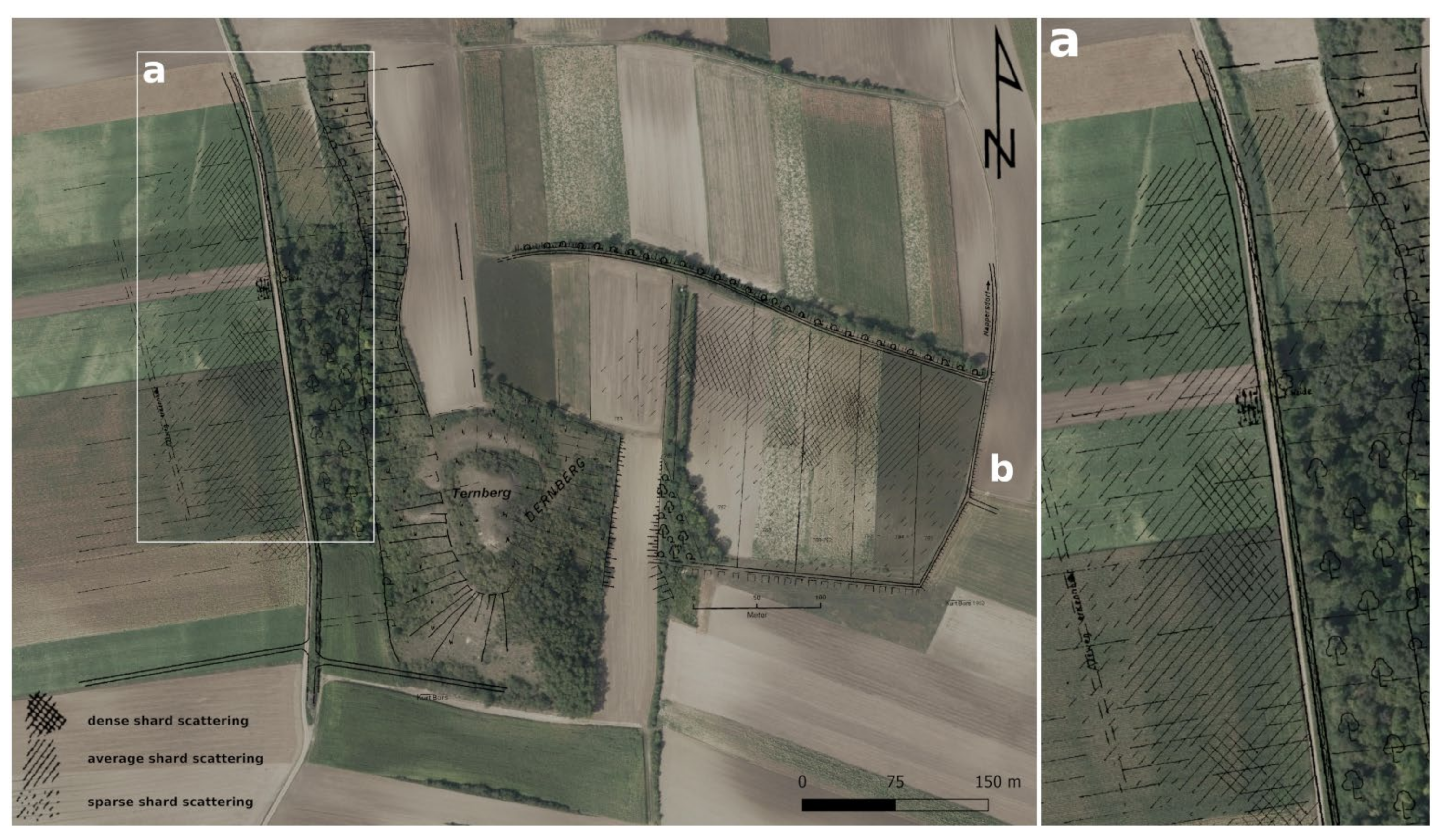
Kurt Bors, who conducted extensive field surveys in the early 1980s at Dernberg and who collected large amounts of medieval pottery sherds, was able to identify two zones with find accumulations, which he interpreted as the position of the former village to the west as well as the manorial farm or bailey to the east of the castle (Figure 2). The pottery was roughly dated from the 9th/10th century to the 15th/16th century. He also excavated parts of the castle together with the Hollabrunn Museum Society in 1984, digging a small trench in its centre, which revealed a Bronze Age settlement pit and a few ceramic fragments from the 13th century [29,30]. As the western accumulation of stray finds corresponds conspicuously well with an old road visible in aerial photographs, which seems to bypass it, the aim of the here presented recent surveys was to clarify whether the village was located in this area (Figure 2a).
Aerial archaeological photography encompasses the identification of vegetation-, soil-, moisture-, flood-, frost-, snow- and shadow-marks in aerial photographs [31]. Agricultural areas are of primary interest, while areas that have been forested for a long time provide excellent conditions for ALS. Forests delay soil erosion and therefore prevent the destruction of archaeological remains. ALS utilises a laser scanner mounted under a crewed aerial vehicle, mapping the topography underneath in high detail. By measuring the exact position and orientation of the scanner, the angle of transmitted electromagnetic radiation pulses and the pulse travel time, the exact position of any reflecting surface can be calculated and displayed as digital point cloud. A point cloud derived from the scan is then filtered and all points not directly on the ground are removed, resulting in a digital terrain model (DTM). In recent years, ALS has gained increasing importance in archaeological research [32,33,34,35,36,37,38,39,40]. For this study, publicly available ALS data already filtered and visualised as hillshade as well as aerial photographs were used in a first step.
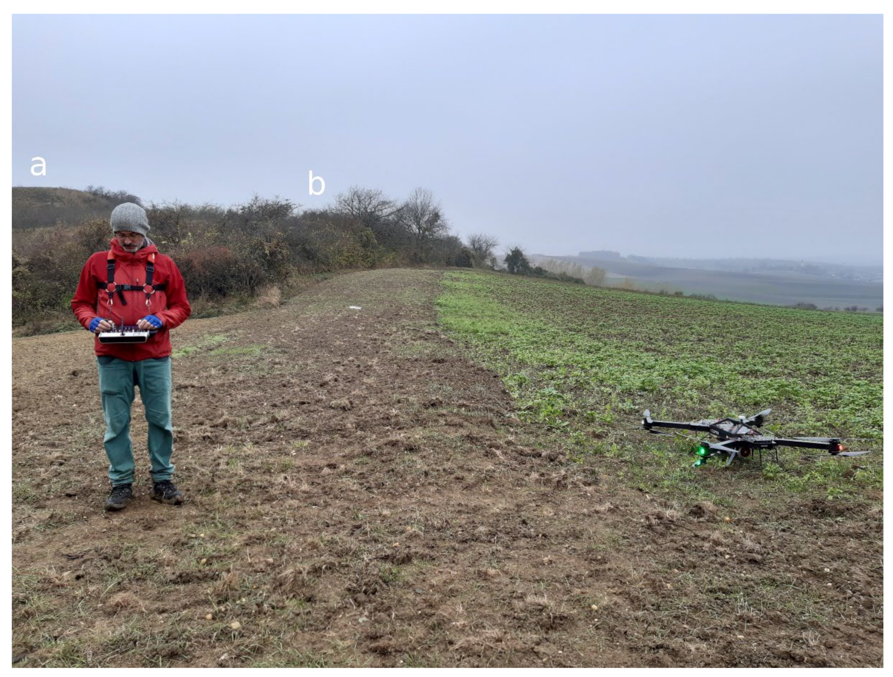
However, the LBI ArchPro recently expanded its remote sensing capabilities with regard to UAV-borne laser scanning. To test the potential of the newly acquired laser scanning system, a small area around the Dernberg was surveyed (Figure 3). The system consisted of a UAV (RiCOPTER) carrying a laser scanner (VUX SYS 1) and two cameras (Sony Alpha 6000) to collect additional conventional photographs. The RiCOPTER was especially designed by RIEGL LMS for ALS purposes and has a total flying mass of 25 kg. The VUX SYS 1 is a reliable laser scanning system also used for crewed aircraft. As the publicly available ALS data for Lower Austria were collected by aeroplanes at significantly higher-flying altitudes above ground and higher speeds, the lower flying altitude and speed of the UAV-based system were assumed to yield a denser point cloud. At the Dernberg the flying altitude was set to 70 m above ground level (AGL). It is important to note that this is the case for the starting point. As the topography changes its elevation above sea level, the AGL varies, respectively. Thus, the speed was reduced to 5 m/s, a comparably low value. Together with a scanning frequency of 550 kHz the number of points per square metre lies within a range of 800–1000 pts/m2.
The system was operated by the following two persons: a pilot and an operator, responsible for the planning of the flight path and operation of the laser scanner. During data collection the system was flying autonomously according to the prepared flight plan along parallel lines. The distance between the lines was set to 50 m, which secured 50% overlap of the individual survey stripes. During processing, the stripes were aligned according to their geometry, global navigation satellite system (GNSS) and inertial measurement unit (IMU) data.
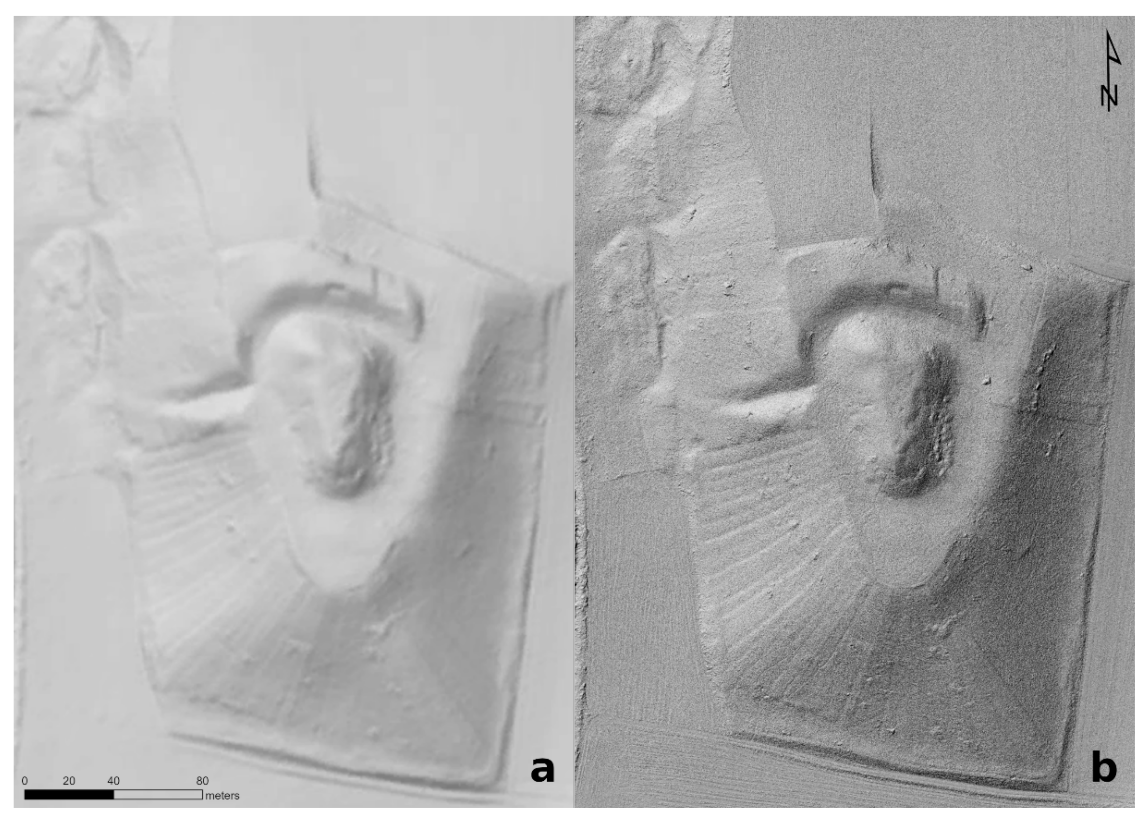
Finally, the recorded points were automatically classified as ground points and vegetation points, respectively, using the RiScan software. Rasterising the ground points produced a DTM with 5 cm cell size, corresponding to 400 pts/m2 (Figure 4b).
A direct comparison between the publicly available ALS data with 1 m cell size (i.e., 1 pt/m²) and the aforementioned UAV scans (5 cm cell size) shows a more detailed depiction of structures in the latter (Figure 4). Although the well-preserved defences of the Dernberg can be observed in both datasets, the potential of the high-resolution scans is, for example, very clearly observable in the vineyard plots laid out radially to the west and south of the hillside. Several landslides on the north-western slope of the hill, the only extensively tree-covered area, also more accentuated here.
As the Dernberg itself is covered by trees and shrubbery, ALS and ULS (uncrewed laser scanning) were the only reasonable methods and allowed us to study it primarily on the basis of its preserved topographical features. Its wider surroundings, however, are used for agriculture, and repeated ploughing has completely levelled any archaeological traces. Therefore, a methodical approach including geophysical methods was sought from the beginning. From 2020 onwards the LBI ArchPro conducted several geophysical surveys at the Dernberg and other suspected deserted villages in the vicinity. Since time and resources for this project were limited, and ground penetrating radar (GPR) surveys at other sites with similar conditions did not yield conclusive results, the team focused on magnetic prospection. For future studies, however, there might still be some potential to obtain more detailed information about certain aspects of the Dernberg by means of GPR [41,42,43].
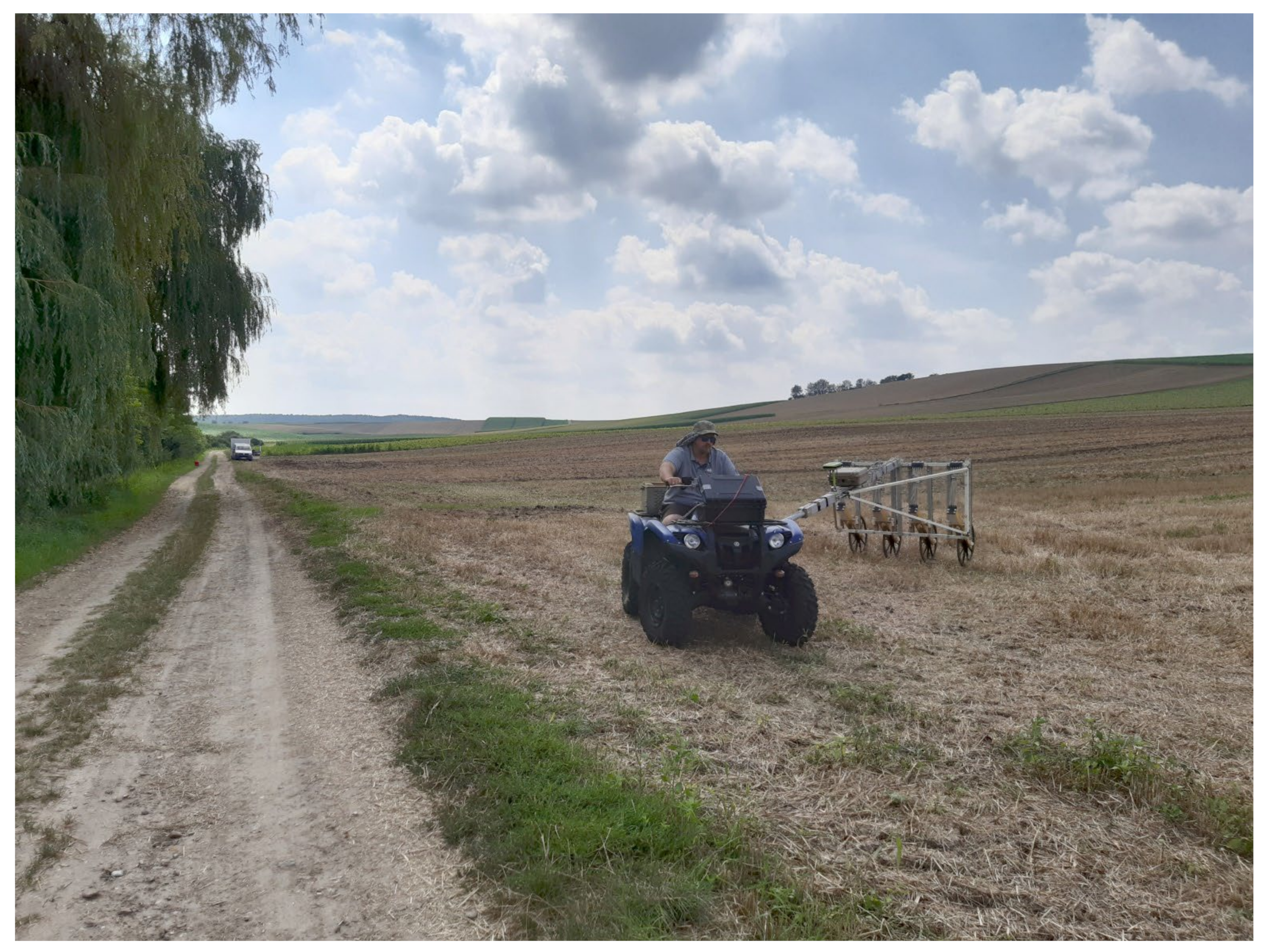
Between 2020 and 2022, slightly over 27 ha surrounding the Dernberg were surveyed with magnetics. The magnetometer system used consisted of eight Förster FEREX CON 650 gradiometer probes, mounted with 25 cm crossline-spacing on a T-shaped non-magnetic cart, pulled by an ATV at a distance of about 6 metres (Figure 5). The sample distance lay at around 10–15 cm at a constant measurement frequency of 50 Hz and a speed between 18 and 27 km/h. The survey fields were flat and well-drained. Most surveys were conducted in good weather conditions during late summer and autumn after the harvest. The magnetic data of the areas surrounding the Dernberg was visualised as black-to-white greyscale images using clip-off values of −2 nT/+3 nT, −4 nT/+6 nT, and −8 nT/+12 nT; however, a range between −2 nT for white and +3 nT for black yielded the best visibility with respect to the majority of detected structures.

3. Results

In the written sources, Dernberg castle, or a manorial farm, and the homonymous village were first mentioned in AD 1208 when Hadmar of Kuenring donated a ‘villa ternberc’ to Zwettl Abbey. The pottery found, on the other hand, suggests inhabitation of the area from the 9th/10th century onward. Its last written mention dates to AD 1590, and some time afterwards, the site was abandoned for good [14,29,44]. According to one source, the village might have been abandoned in the early 14th century, as it mentions a ‘villa desolata’ in AD 1313. However, this is doubtful based on other written records as well as archaeological evidence. The source might refer to the castle or the temporary abandonment of the said settlement. The village is still mentioned in AD 1590 with 12 inhabited houses [44] and presumably existed beyond that date until the 17th century [14].
Therefore, neither the time of establishment nor of the abandonment of the castle and village can be determined precisely based on written sources. The written evidence is even less informative with regard to the form of both, since in some cases, it is not possible to clearly distinguish whether a settlement or castle is described in the source.
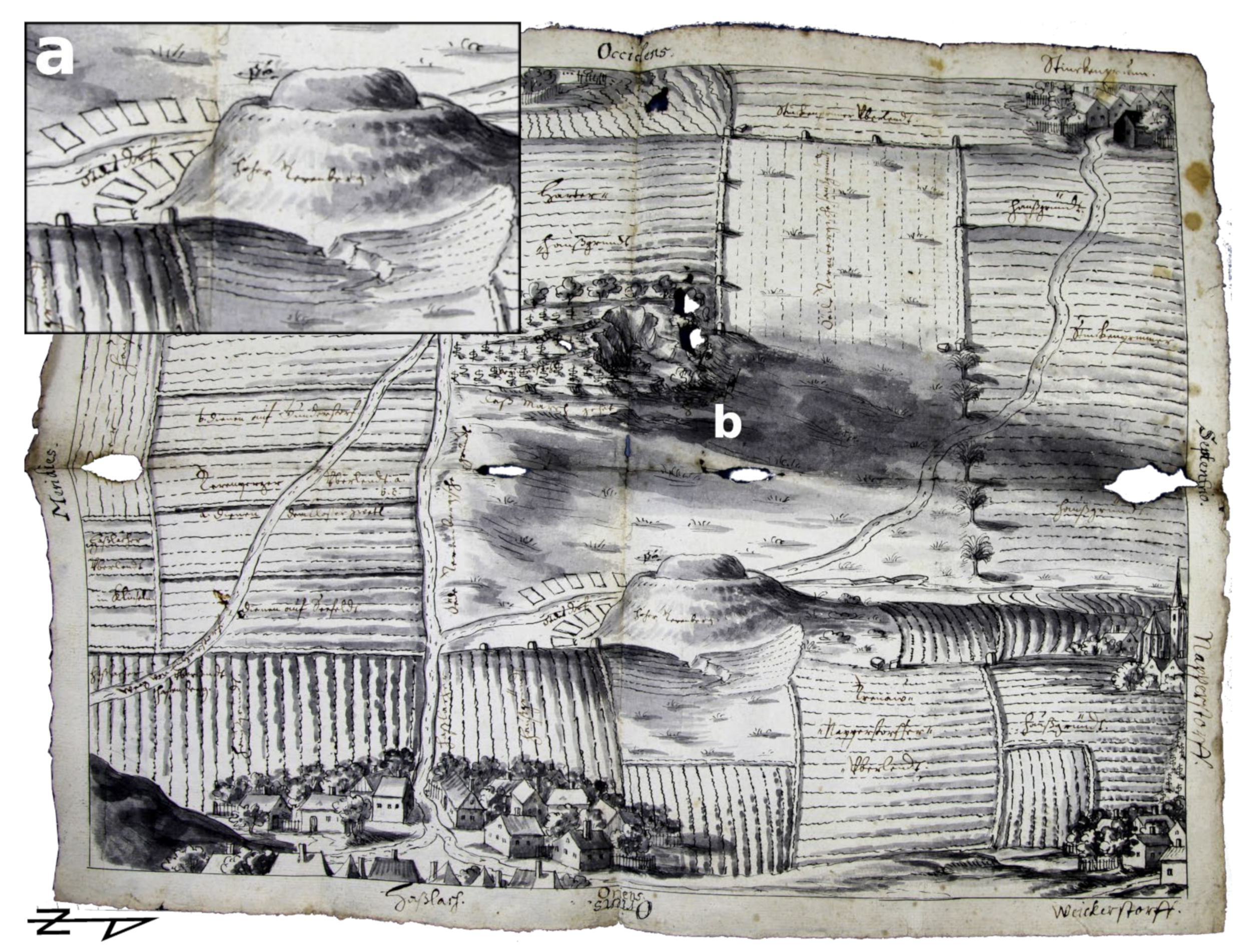
However, a historical map from AD 1704 (Figure 6) indicates that the village may have been inhabited well into the 17th century and probably outlived the castle. The map is kept in the archives of Zwettl Abbey. In its centre, the Dernberg is depicted, now only an earthwork, whose rampart and moat seem to have been preserved in a similar form as they still are today. To the west and on both sides of the road, a total of nine rectangular plots are depicted (Figure 6a), together with the annotation ‘Oedes dorf’ (deserted village). The two northernmost plots are partially obscured by the castle hill, and it seems quite conceivable that there were still 12 in total as mentioned in the written document from AD 1590. To the west, a large and to the east, a small desolate field are indicated, the former with the annotation ‘Oede Dernbergsche gründt’ (Dernberg’s deserted lands). In the smaller field as well as in the vineyards on the western slopes (Figure 6b), possible consequences or even causes of abandonment can also be identified, as two distinct erosion gullies were documented.
Although this evidence of the village must be regarded as a stroke of luck, as early modern maps very rarely offer such clear indications. Additionally, if the Dernberg, as such a distinctive landmark, did not form an excellent reference point, the exact position of the village would be very doubtful due to the generally low accuracy and great simplification of this early map.
In contrast, the 19th-century Franciscan Cadastre (Figure 7a) can be regarded as a highly accurate map, with an average inaccuracy of only 80 cm in open terrain [18]. In the publicly available hillshade visualisation based on ALS data (Figure 7b), one can see the Dernberg’s fortifications, its outer rampart (C), moat (D), and terrace €, and the central motte (F), together with several landslides (G) at the north-western foot of the castle hill. In comparison with a publicly available georeferenced version of the Franciscan Cadastre, it becomes apparent that the road discussed above was used at least until the early 19th century. The area along the brook in between the road and the castle hill, including the former village, in contrast to the surrounding area marked as arable land (ochre), was used as a meadow (green). Presumably, it was periodically too wet for grain cultivation. Furthermore, parts of the castle hill are marked green as well, although most of its slopes were used as vineyards (red), which in turn may have been and still are too steep for grain, as can be well understood by comparing these areas with the DTM as well as images of the site (Figure 8).
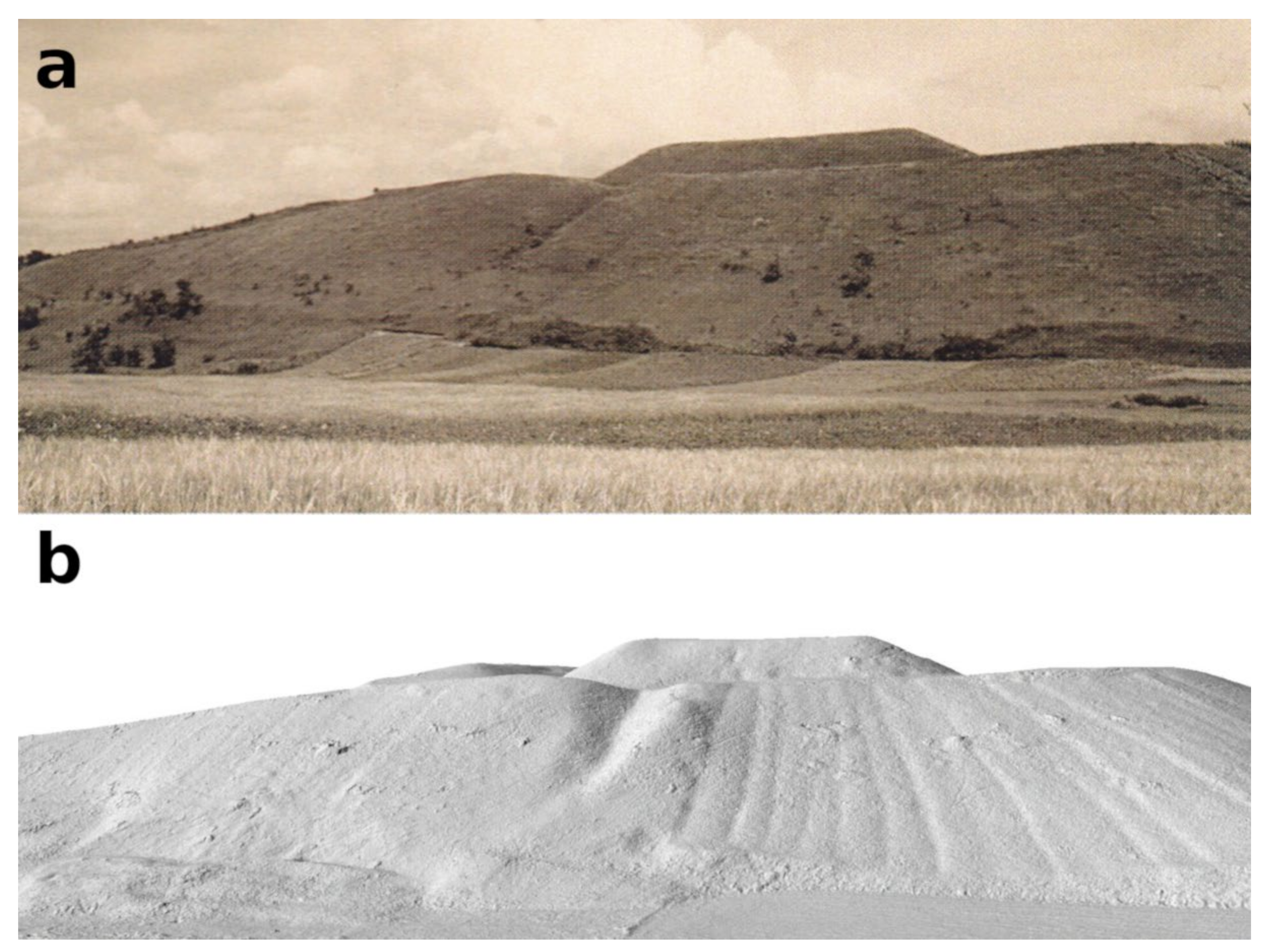
The newly acquired UAV scans of the Dernberg additionally allowed for the study of the terrain with regard to its development within recent decades. In a photograph of the Dernberg taken from the west in 1937 (Figure 8a), it can be discerned that at that time it was exclusively overgrown with grass and thus probably exposed to a greater danger of erosion than today. The picture also shows the vineyard plots and some landslides, as well as an erosion channel that can also be observed in the DTM. With a three-dimensional representation of the scans using a GIS, an attempt was made to recreate the perspective of the photographer in order to make these structures more comparable (Figure 8b). According to this comparison, the cause of the landslides seems to lie in a former path or field boundary which, as can be seen in the photo, cut into the slope of the hill and, below which, larger volumes of soil seem to have slid. However, whether this actually occurred after 1937 or whether the microtopography is merely not so clearly visible in the photograph, it cannot be conclusively decided. In any case, this area is of great interest—as a part of the village must be presumed here—and can hardly be investigated via any other source.
The magnetic data, however, revealed even more valuable information about the site. Across the entire survey area, numerous traces of prehistoric inhabitation can be observed in the form of magnetic anomalies interpreted as massive pits and ditches, which are also well documented by archaeological finds. Therefore, it was rather challenging, in general, to identify medieval structures with confidence. In addition, several major erosion events are also evident in the data, which, although destroying some of the archaeological structures, provided valuable information for the interpretation. This concerns both chronological classification and causal correlations, as will be discussed in more detail below.
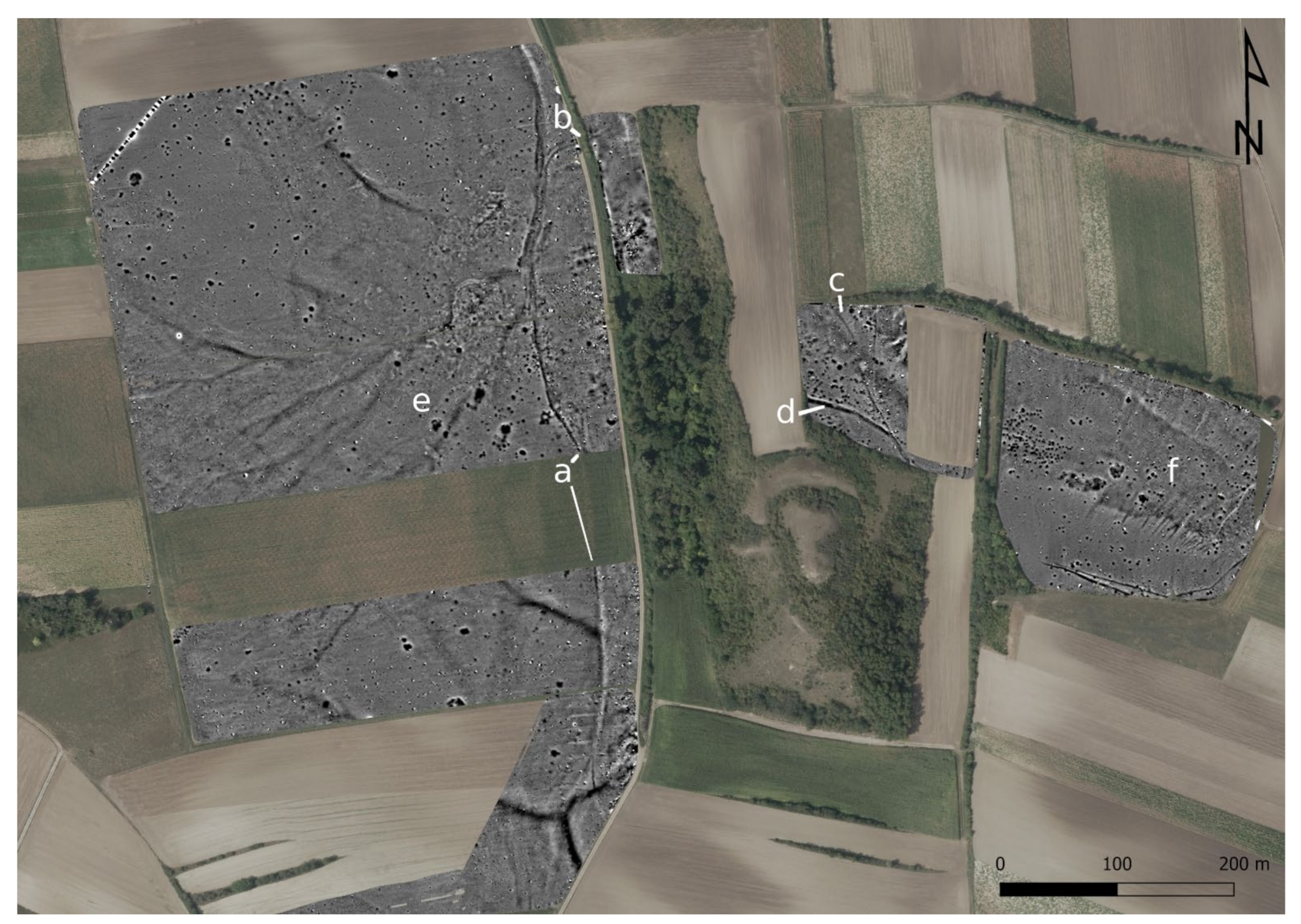
The road, previously observed both in aerial images (Figure 2) as well as historical maps (Figure 6 and Figure 7), can be discerned very well in the magnetic data (Figure 9a), including its partial erosion to a holloway in the north, probably due to heavy rainfall. At the northern edge of the village, the road splits and continues not only to the north but also branches off to the east (Figure 9b). As the path should have crossed the brook here, a small bridge is to be expected, as it is still attested at this place in the 19th century. The path reappears further to the southeast in the surveyed area on the northern slope of the castle hill (Figure 9c). To the northeast of the castle, it crosses a wide ditch (Figure 9d), which was probably constructed as a moat to protect the northern side of the complex in front of the outer rampart. The road seems to superimpose the moat; thus, it is not possible to say with certainty whether the moat belongs to the preceding prehistoric hilltop settlement or is part of the medieval castle.
Two massive erosion events can be observed in the data. One accumulates on the western slopes (Figure 9e) and runs towards the northeast, where it seemingly runs into the holloway at the village boundary, widening the holloway from 3 m to as much as 10 m. Another erosion event, represented by numerous small and parallel erosion gullies (Figure 9f) as evidence, can still be observed to the east and therefore in the area of the suspected bailey. They seem to have originated from older plough marks of unknown age. However, their establishment during the early modern period after the abandonment of the bailey seems most likely.

4. Discussion

Even if these archaeological prospection results provide important new insights, they do not allow any clear conclusions about the structure, development, and economic basis of the village. Naturally, historical maps are only able to answer such questions to a limited degree. In the following, this article will nevertheless make an attempt to analyse the cadastre in this respect. Each consideration will be elaborated on and weighed up. A critical discussion will follow, addressing the future potentials as well as limitations of the method.
The stratigraphic analysis of the Franciscan Cadastre (Figure 10) around the Dernberg mainly yielded temporal information on the village as the area of the castle hill itself underwent less fundamental reorganisation over time. It suggests that the former road to the west, as observed in the prospection data and the historical map, might be seen as one of the oldest structures in the area. It must have preceded the establishment of the village along its course, even though the western bypass may be younger than the village itself.
The map also shows a clear difference between the orientation and the width of the plots east and west of the road (Figure 7a and Figure 10a). From this, it can be concluded that these two sides were not originally a block of farmland that was later separated by the road but, conversely, were laid out along the older road.
The additional information on the use of the western fields in the historical map as arable land (ochre) while the plots in the east were used as meadows (green) would also suggest a different time of establishment and an originally differing utilisation. It has therefore been concluded that at the time of the medieval village, fields only existed on the western side of the road and that their orientation might not have changed significantly until the 19th century (apart from the presumed repeated subdivision or consolidation of plots when ownership changed).
In the area of the floodplain along the brook, only pasture cultivation was possible due to periodic flooding or too wet soil. Within the village boundaries, herb and vegetable gardens must nevertheless be assumed, which were probably protected by local drainage precautions, as known from other deserted villages in the vicinity [14]. After the abandonment of the village, this area must have been again used as a meadow and divided into new, differently oriented plots for administrative reasons. Thus, these plots were laid out across the brook without taking it into account and should therefore not be considered stratigraphically older.
Another observation might contradict this hypothesis at first glance. South of the village, the road splits, with both the western and eastern roads intersecting the plots on the respective sides of the brook (Figure 10a). Following the theoretical principles just outlined, these roads would therefore have to be younger than the fields (Figure 10b). Consequently, the northern part of the road must be older than its southern branches.
To gain more clarity on this question, the area outside the suspected settlement was surveyed using magnetic prospection. In a subsequent comparison between the cadastre (Figure 10c) and the magnetic data (Figure 10d), the presumed junction (Figure 10E) was clearly observable in the form of a positive magnetic linear anomaly. The data shows that, indeed, two roads must have split up here before the western branch was abandoned. Maybe due to continuous damage by erosion after heavy rainfall, as the magnetic data furthermore shows a strong positive magnetic possible erosional channel leading into the brook and superimposing the two roads. However, the western road must have been more affected (Figure 10F).
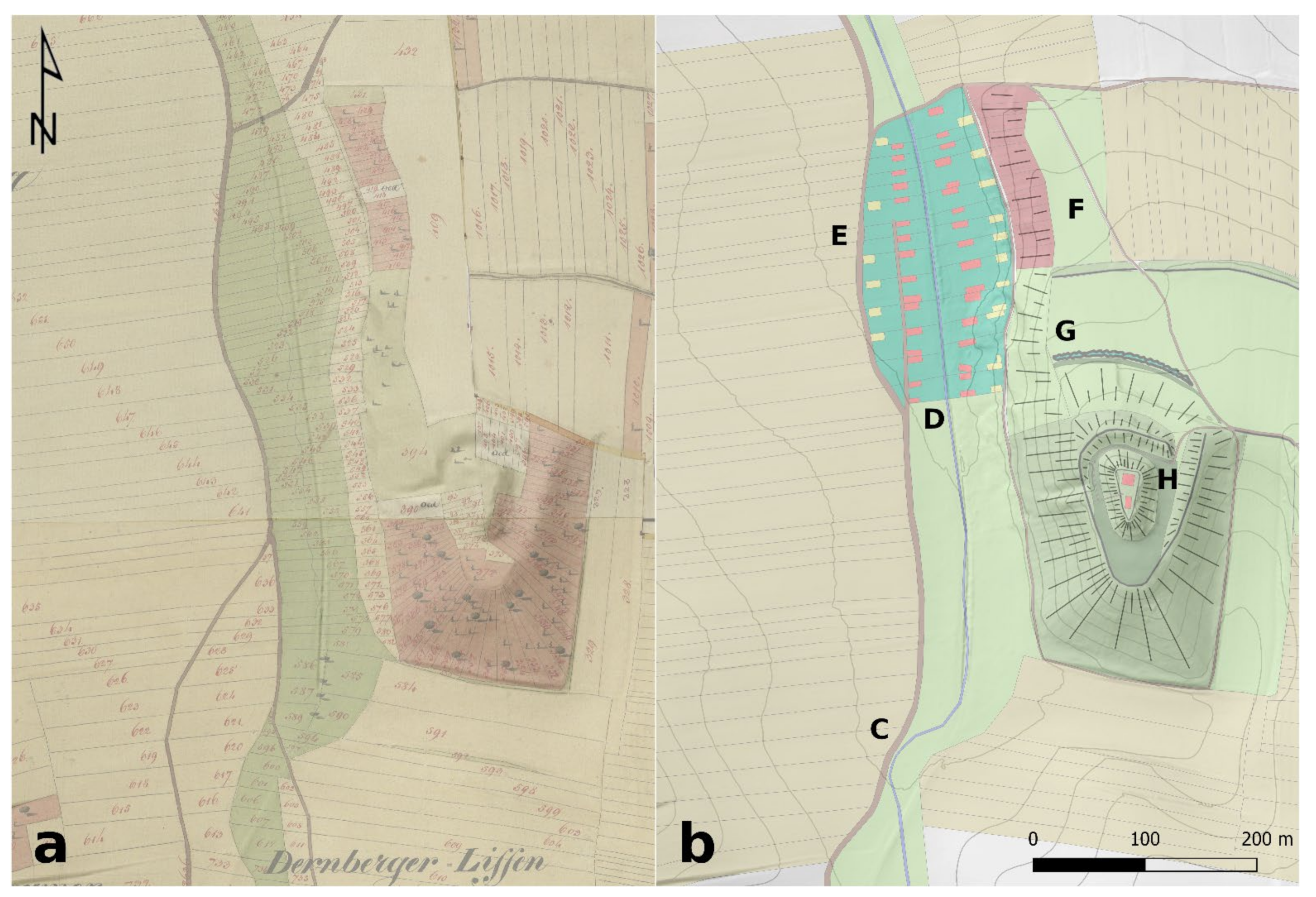
On the basis of both the historical maps, aerial images, and ALS as well as geophysical data, a possible interpretation of the Dernberg together with the village to its northwest and their surrounding field system and road network is presented here (Figure 11). This possible contemporaneous arrangement of the interpreted structures might be roughly placed in the late Middle Ages or the early modern period. The road, coming from the southwest, ran along the natural division between arable land on the western slopes and the brook’s floodplain, which used as a meadow. The course of the brook must have barely changed since that time.
In the area of the former junction of the road, however, the magnetic data indicate a former strong bend in the brook, which may have caused the original path to deviate to the west here (Figure 11C). At the southern end of the village, the meadows may have turned into the village green (Figure 11D). The magnetic data show traces of a road reaching into the village from the south, indicating that it originally continued straight. To the east of it, the first row of houses may have been laid out, whose western gardens eventually must have caused the street to be relocated further west, bypassing the village (Figure 11E).
The number of individual farms and the width of the farm plots are speculative and were determined by later field widths, empirical values, and the map of AD 1704. The same applies to the positions of the houses and the entire eastern village line. These merely illustrate a common early modern village layout and could not be clearly proven or disproven by the data. However, the topography on both sides of the brook would support such an interpretation. The road branching off north of the village, continuing to the east across the brook, and probably leading further southeast to the castle (Figure 11F), on the other hand, is well documented in the data, as are parts of the moat (Figure 11G) running in front of the outer rampart in the north. Its continuation to the west until the edge of the terrain above the village seems very plausible to fortify the rather flat northern slope. There is also no decisive data on the arrangement of the castle; however, a tower constructed of wood or stone in the north, as well as a possible further building, can be presumed (Figure 11H).
We would hereby like to emphasise that only by integrating historical and archaeological sources can a picture of the Dernberg and its settlement, as well as their development, can be drawn as complete as possible. While surface finds and archaeological prospection allow for a very specific localisation and delimitation of the sites, the written sources provide unique information on toponyms, ownership, and inhabitants. Yet, while the written sources alone did not allow a clear identification, the archaeological data would only be evidence of another nameless settlement. Both historical maps and magnetic data provide additional very compelling evidence of massive erosion events, and thus potentially of crucial extreme weather events or excessive agricultural land use, a topic that has become increasingly important in recent years [45,46,47,48,49]. However, the authors see the greatest potential of the historical maps in their preservation of old field boundaries and path routes. This not only enables the derivation of diachronic developments; it also provides information on infrastructural patterns that typically cannot be investigated very well either through historical or archaeological sources.

5. Conclusions

Finally, it can be concluded that the Dernberg was a medieval motte-and-bailey castle with an adjoining village to the west that likely survived the castle and may have been inhabited well into the 17th century. The written records are scarce, although allowing for the determination of a minimum occupation phase from the early 13th to the late 16th century AD. However, the first indications of the position of the village could only be found in the collection of surface finds from the 1980s onwards. This could subsequently also be confirmed by aerial photographs. The magnetic prospection data presented here and the systematic analysis of the historical maps make it possible to further consolidate this assumption. In addition, there is evidence of several erosion events that are also depicted in a map of the early 18th century and that might be related to the abandonment of the village. The stratigraphic evaluation of the Franciscan Cadastre, under consideration of the magnetic data, allows certain conclusions to be drawn about the diachronic development of the surrounding traffic routes and agricultural structures that would otherwise not have been possible. In addition, it should be noted here that the present case study concerns a very small area and is a selective proof of this concept. The true value of this method, however, lies in applying it on a large scale to whole regions and landscapes, as it will reveal many more stratigraphic relationships of the numerous structures under investigation. This is not only expected to add quantitative value to an area-wide classification and chronological assessment, but the dating of the individual structures should also be improved by a greater number of reference points.

Author Contributions

Conceptualization, R.F. and M.D.; Data curation, R.F., D.R., M.D., G.H. and G.Z.; Formal analysis, R.F.; Investigation, R.F., D.R. and M.K., Geert Verhoeven, G.Z., A.L., G.S. and M.P.; Methodology, R.F., M.K., M.D. and W.N.; Resources, M.D. and W.N.; Visualization, R.F.; Writing—original draft, R.F.; Writing—review and editing, R.F., D.R., M.K., M.D., G.H., G.J.V., G.Z., A.L., M.P. and W.N. All authors have read and agreed to the published version of the manuscript.

Funding

This research received no external funding.

Institutional Review Board Statement

Not applicable.

Informed Consent Statement

Not applicable.

Data Availability Statement

Not applicable.

Acknowledgments

The Ludwig Boltzmann Institute for Archaeological Prospection and Virtual Archaeology (https://archpro.lbg.ac.at, accessed on 26 April 2022) is based on an international cooperation of the Ludwig Boltzmann Gesellschaft (A), Amt der Niederösterreichischen Landesregierung (A), University of Vienna (A), TU Wien (A), ZAMG—Central Institute for Meteorology and Geodynamics (A), 7 reasons (A), LWL—Federal state archaeology of Westphalia-Lippe (D), NIKU—Norwegian Institute for Cultural Heritage (N), Vestfold fylkeskommune—Kulturarv (N), DUK—University for Continuing Education Krems (A), and SRS—Spanish Riding School (A). We would like to thank Nina Richards and Christopher Richards for proofreading, Andreas Gamerith (Stiftsarchiv Zwettl) for access to the archives of Zwettl Abbey, Thomas Kühtreiber (Institute for Medieval and Early Modern Material Culture, University of Salzburg) for advice as well as Gabriele Scharrer-Liška (Vienna Institute for Archaeological Science, University of Vienna) and the Austrian Society for Medieval Archaeology (ÖGM) for advice and access to the deserted village archives.

Conflicts of Interest

The authors declare no conflict of interest.

Notes

1
Data according to https://bodenkarte.at (accessed on 24 March 2021).
2

References

  1. Bors, K. Methodische Erfahrungen in der Ortswüstungsforschung. Beiträge zur Mittelalterarchäologie in Österreich—Beiheft 7; Österreichische Gesellschaft für Mittelalterarchäologie: Wien, Austria, 2007. [Google Scholar]
  2. Hofstätter, E. Beiträge zur Geschichte der Österreichischen Landesaufnahmen—Ein Überblick der Topographischen Aufnahmeverfahren, deren Ursprünge, Ihrer Entwicklungen und Organisationsformen der vier Österreichischen Landesaufnahmen. Teil 1; Bundesamt für Eich- und Vermessungswesen: Wien, Austria, 1989; Volume 1. [Google Scholar]
  3. Rill, R. Die Anfänge der Militärkartographie in den habsburgischen Erblanden: Die Josephinische Landesaufnahme von Böhmen und Mähren nach hofkriegsrätlichen Quellen. Mitteilungen des Österreichischen Staatsarchivs 2001, 49, 183–202. [Google Scholar]
  4. Scharrer-Liška, G. Überblick zu modernen und naturwissenschaftlichen Prospektionsmethoden in der Wüstungs- und Ortswüstungsforschung. Beiträge zur Mittelalterarchäologie Österreich 2001, 7, 63–78. [Google Scholar]
  5. Filzwieser, R.; Eichert, S. Towards an Online Database for Archaeological Landscapes. Using the Web Based, Open Source Software OpenAtlas for the Acquisition, Analysis and Dissemination of Archaeological and Historical Data on a Landscape Basis. Heritage 2020, 3, 1385–1401. [Google Scholar] [CrossRef]
  6. Neubauer, W. Magnetische Prospektion in der Archäologie; Verlag der Österreichischen Akademie der Wissenschaften: Wien, Austria, 2001. [Google Scholar]
  7. Filzwieser, R.; Aldrian, L.; Stadler, H.; Neubauer, W. Burg Schönwerth—Archäologische Re-Prospektion einer wüsten mittelalterlichen Niederungsburg in Volders, Tirol. Archaeol. Austriaca 2021, 105, 205–222. [Google Scholar] [CrossRef]
  8. Kühtreiber, K. Zu den mittelalterlichen Wüstungen im Leitharaum. In Die Leitha—Facetten einer Landschaft; Doneus, M., Griebl, M., Eds.; Österreichische Gesellschaft für Ur- und Frühgeschichte und AutorInnen: Wien, Austria, 2015; pp. 233–247. [Google Scholar]
  9. Andrén, A. Between Artifacts and Texts—Historical Archaeology in Global Perspective; Plenum Press: New York, NY, USA, 1998. [Google Scholar]
  10. Schad‘n, H.P. Die Hausberge und Verwandten Wehranlagen in Niederösterreich. Ein Beitrag zur Geschichte des Befestigungswesens und seiner Entwicklung vom Ringwall bis zur Mauerburg und Stadtumwehrung. Prähistorische Forschungen 1953, 3. [Google Scholar]
  11. Schad´n, H.P. Die Hausberge und verwandten Wehranlagen in Niederösterreich. Ein Beitrag zur Geschichte des mittelalterlichen Befestigungswesens und seiner Entwicklung vom Ringwall bis zur Mauerburg und Stadtumwehrung. Mitteilungen der Anthropol. Gesellschaft Wien 1950, 80, 245–352. [Google Scholar]
  12. Schad´n, H.P. Die Hausberge und verwandten Wehranlagen in Niederösterreich. Ein Beitrag zur Geschichte des mittelalterlichen Befestigungswesens und seiner Entwicklung vom Ringwall bis zur Mauerburg und Stadtumwehrung. Mitteilungen der Anthropol. Gesellschaft Wien 1953, 81, 25–185. [Google Scholar]
  13. Bors, K. Wüstungsforschung um das ‘Lange Thal’ bei Hollabrunn. Unsere Heim. 1988, 59, 328–355. [Google Scholar]
  14. Hasenhündl, G. Der Wilde Osten vor 1000 Jahren. Von Hausbergen und ‘Versunkenen’ Dörfern; Hollabrunner Museumsverein: Hollabrunn, Austria, 2018. [Google Scholar]
  15. Reichhalter, G.; Kühtreiber, K.; Kühtreiber, T. Burgen Weinviertel; Freytag & Berndt: Wien, Austria, 2005. [Google Scholar]
  16. Fittner, W.J. Abgekommene Orte um das ‘Lange Thal’ bei Hollabrunn. Jahrb. Landeskd. Niederosterr. 2019, 85, 77–91. [Google Scholar]
  17. Kupfer, E. Das Weinviertel. Herrschaft, Siedlung und Soziales Geflecht im Hohen Mittelalter; Independently Published, 2017. [Google Scholar]
  18. Fuhrmann, S. Digitale Historische Geobasisdaten im Bundesamt für Eich- und Vermessungswesen (BEV)—Die Urmappe des Franziszeischen Kataster. Österreichische Zeitschrift für Vermessung Geoinf. 2007, 95, 24–35. [Google Scholar]
  19. Harris, E.C. Principles of Archaeological Stratigraphy; Academic Press: Cambridge, MA, USA, 1989. [Google Scholar]
  20. Neubauer, W. GIS in Archaeology—the Interface between Prospection and Excavation. Archaeol. Prospect. 2004, 11, 159–166. [Google Scholar] [CrossRef]
  21. Filzwieser, R. Burg und Herrschaft Scharfeneck am Leithagebirge aus Landschaftsarchäologischer und Historischer Perspektive. Beiträge zur Mittelalterarchäologie in Österreich—Beiheft 12; Österreichische Gesellschaft für Mittelalterarchäologie: Wien, Austria, 2021. [Google Scholar]
  22. Kühtreiber, T.; Tarcsay, G.; Zorko, M.; Hinterwallner, M.; Krenn, M. Abandoned Villages and Farmsteads on Modern Military Training Grounds: Rural Settlement Studies at the Allentsteig Military Training Area: Between Academic Research and National Heritage Protection. Soc. Hist. Archaeol. Newsl. 2014, 47, 9–12. [Google Scholar]
  23. Schwarz, K. Archäologisch-Topographische Studien zur Geschichte Frühmittelalterlicher Fernwege und Ackerfluren: Im Alpenvorland Zwischen Isar, Inn und Chiemsee; Karten; Lassleben: Whittier, CA, USA, 1989. [Google Scholar]
  24. Schwarz, K. Archäologisch-Topographische Studien zur Geschichte Frühmittelalterlicher Fernwege und Ackerfluren: Im Alpenvorland Zwischen Isar, Inn und Chiemsee; Textband; Lassleben: Whittier, CA, USA, 1989. [Google Scholar]
  25. Traxler, C.; Neubauer, W. The Harris Matrix Composer—A New Tool to Manage Archaeological Stratigraphy. In Proceedings of the Digital Heritage—Proceedings of the 14th International Conference on Virtual Systems and Multimedia, Limassol, Cyprus, 20–25 October 2008; pp. 13–20. [Google Scholar]
  26. Neubauer, W.; Traxler, C.; Lenzhofer, A.; Kucera, M. Integrated spatio-temporal documentation and analysis of archaeological stratifications using the Harris Matrix. In Proceedings of the 16th Eurographics Workshop on Graphics and Cultural Heritage (GCH 2018), Wien, Austria, 12–15 November 2018; pp. 235–239. [Google Scholar] [CrossRef]
  27. Neubauer, W.; Traxler, C.; Bornik, A.; Lenzhofer, A. Stratigraphy from Topography I—Theoretical and practical considerations for the application of the Harris Matrix for the GIS-based spatio-temporal archaeological interpretation of topographical data. Archaeol. Austriaca 2022. in praparation. [Google Scholar]
  28. Doneus, M.; Neubauer, W.; Filzwieser, R.; Sevara, C. Stratigraphy from Topography II—The practical application of the Harris Matrix for the GIS-based spatio-temporal archaeological interpretation of topographical data. Archaeol. Austriaca 2022. submitted. [Google Scholar]
  29. Bors, K. KG Haslach, MG Nappersdorf-Kammersdorf, VB Hollabrunn. Fundberichte aus Österreich 1984, 22, 324. [Google Scholar]
  30. Bors, K. KG Haslach, MG Nappersdorf-Kammersdorf, VB Hollabrunn. Fundberichte aus Österreich 1986, 23, 320. [Google Scholar]
  31. Wilson, D.R. Air Photo Interpretation for Archaeologists; The History Press Ltd.: Gloucestershire, UK, 2000. [Google Scholar]
  32. Doneus, M.; Briese, C. Airborne Laser Scanning in forested areas—Potential and limitations of an archaeological prospection technique. In Remote Sensing for Archaeological Heritage Management, Proceedings of the 11th EAC Heritage Management Symposium, Reykjavík, Iceland, 25–27 March 2010; Europae Archaeologia Consilium (EAC): Brussels, Belgium, 2011; pp. 59–76. [Google Scholar]
  33. Forte, M.; Campana, S. (Eds.) Digital Methods and Remote Sensing in Archaeology; Archaeology in the Age of Sensing; Springer: Cham, Switzerland, 2016. [Google Scholar] [CrossRef]
  34. Doneus, M. Die hinterlassene Landschaft—Prospektion und Interpretation in der Landschaftsarchäologie; Österreichische Akademie der Wissenschaften: Wien, Austria, 2013. [Google Scholar]
  35. Hesse, R. Possibilities and challenges in the application of multi-temporal airborne lidar data sets for the monitoring of archaeological landscapes. In Proceedings of the 20th International Conference on Cultural Heritage and New Technologies, Vienna, Austria, 2–4 November 2015. [Google Scholar]
  36. Opitz, R.; Cowley, D. (Eds.) Interpreting Archaeological Topography—Airborne Laser Scanning, 3D Data and Ground Observation; Oxbow Books: Oxford, UK, 2013. [Google Scholar]
  37. Štular, B.; Eichert, S.; Lozić, E. Airborne LiDAR Point Cloud Processing for Archaeology. Pipeline and QGIS Toolbox. Remote Sens. 2021, 13, 3225. [Google Scholar] [CrossRef]
  38. Štular, B.; Lozić, E.; Eichert, S. Airborne LiDAR-Derived Digital Elevation Model for Archaeology. Remote Sens. 2021, 13, 1855. [Google Scholar] [CrossRef]
  39. Kokalj, Ž.; Somrak, M. Why not a single image? Combining visualizations to facilitate fieldwork and on-screen mapping. Remote Sens. 2019, 11, 747. [Google Scholar] [CrossRef] [Green Version]
  40. Zakšek, K.; Oštir, K.; Kokalj, Ž. Sky-View Factor as a Relief Visualization Technique. Remote Sens. 2011, 3, 398–415. [Google Scholar] [CrossRef] [Green Version]
  41. Filzwieser, R.; Olesen, L.H.; Verhoeven, G.; Mauritsen, E.S.; Neubauer, W.; Trinks, I.; Nowak, M.; Nowak, R.; Schneidhofer, P.; Erich Nau, E.; et al. Integration of Complementary Archaeological Prospection Data from a Late Iron Age Settlement at Vesterager—Denmark. J. Archaeol. Method Theory 2018, 25, 313–333. [Google Scholar] [CrossRef]
  42. Tonning, C.; Schneidhofer, P.; Nau, E.; Gansum, T.; Lia, V.; Gustavsen, L.; Filzwieser, R.; Wallner, M.; Kristiansen, M.; Neubauer, W. Halls at Borre: The discovery of three large buildings at a Late Iron and Viking Age royal burial site in Norway. Antiquity 2020, 94, 145–163. [Google Scholar] [CrossRef]
  43. Filzwieser, R.; Toriser, L.; Valdelomar, J.T.; Neubauer, W. Investigation and virtual visualisation of a probable burial mound and later motte-and-bailey castle from Lower Austria. In Proceedings of the 12th International Conference on Archaeological Prospection, Bradford, UK, 12–16 September 2017; pp. 81–83. [Google Scholar]
  44. Klein, K. (Ed.) Historisches Ortslexikon. Niederösterreich 2. Teil—Hollabrunn, Horn, Korneuburg, Krems (Land), Lilienfeld, Melk; Austrian Academy of Sciences: Wien, Austria, 2016; pp. 1–173. [Google Scholar]
  45. Schreg, R. Plague and Desertion—A Consequence of Anthropogenic Landscape Change? Archaeological Studies in Southern Germany. In The Crisis of the 14th Century; De Gruyter: Berlin, Germany, 2020. [Google Scholar] [CrossRef]
  46. Dotterweich, M.; Schreg, R. Archaeonics—(Geo)archaeological studies in Anthropogenic Dark Earths (ADE) as an example for future-oriented studies of the past. Quat. Int. 2019, 502, 309–318. [Google Scholar] [CrossRef]
  47. Bork, H.R. Spuren in der Landschaft: Extreme Witterungsereignisse während des Spätmittelalters und ihre Folgen. Dtsch. Wasserhistorische Ges. Schr. 2013, 22, 107–126. [Google Scholar]
  48. Schreg, R. Ecological Approaches in Medieval Rural Archaeology. Eur. J. Archaeol. 2014, 17, 83–119. [Google Scholar] [CrossRef]
  49. Werther, L.; Mehler, N.; Schenk, G.J.; Zielhofer, C. On the Way to the Fluvial Anthroposphere—Current Limitations and Perspectives of Multidisciplinary Research. Water 2021, 13, 2188. [Google Scholar] [CrossRef]
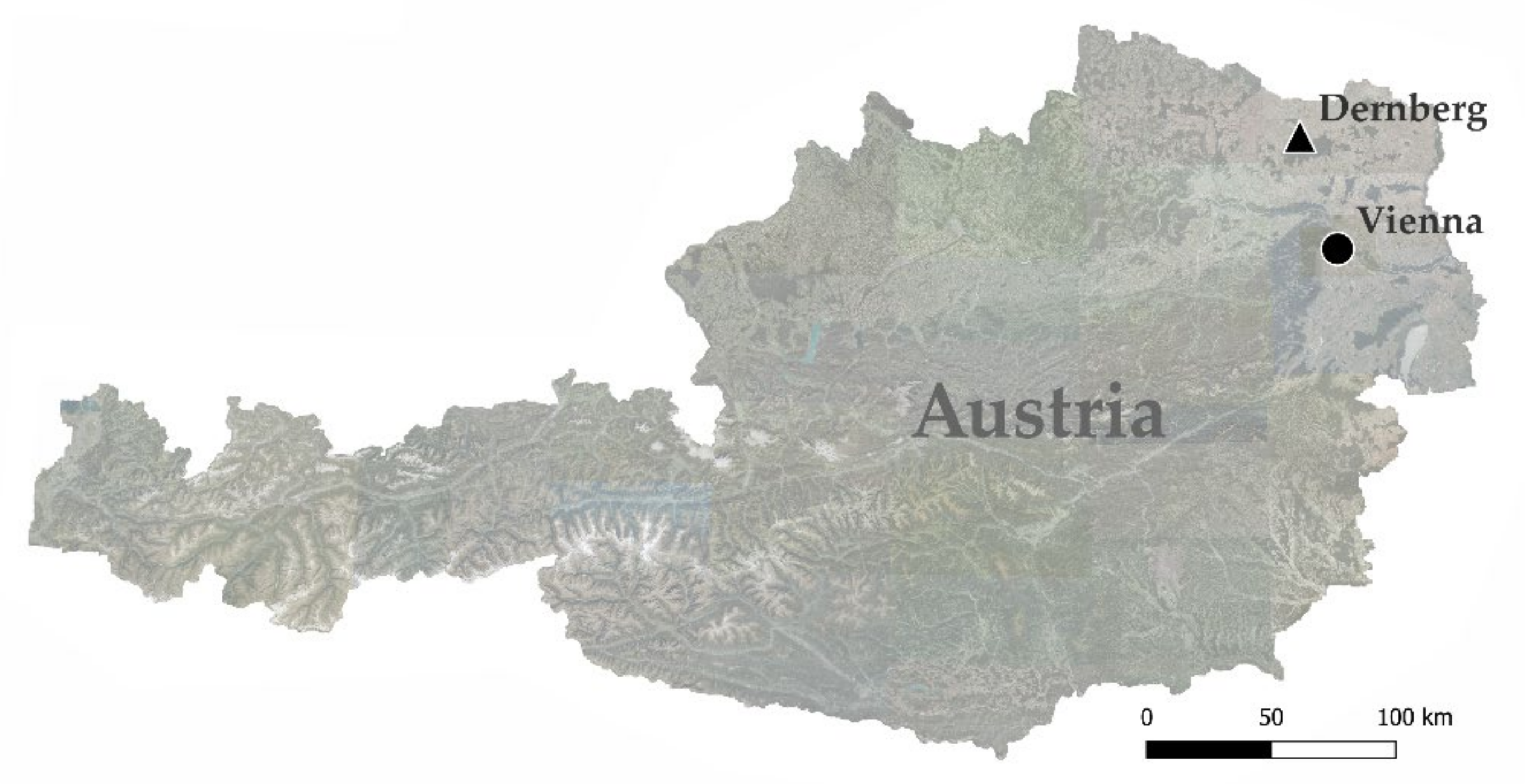
Figure 1. Position of the Dernberg about 40 km north of Vienna and 14 km south of the Czech border. (Data source: https://basemap.at (accessed on 26 April 2022)).
Heritage 05 00111 g001
Figure 2. Orthophoto showing the today partly overgrown castle hill of the Dernberg as well as a linear negative crop mark to the northwest, indicating the former road and where it evaded the village. The aerial photo is overlain by two sketches of collected surface finds, drawn by Kurt Bors. The western accumulation (a) of finds corresponds conspicuously well with the road and was interpreted as location of the deserted village, the eastern accumulation (b) may indicate the castle’s bailey. (Data source: Orthophoto: https://basemap.at (accessed on 26 April 2022). Sketches: Kurt Bors 1983; https://www.univie.ac.at/wuestungsforschung/archiv.htm (accessed on 26 April 2022), Ternberc 1804-1 and Trennau 1823-2).
Heritage 05 00111 g002
Figure 3. Surveying the Dernberg, using a RIEGL VUX SYS 1 LiDAR Sensor mounted under a UAV (RiCOPTER). View from between the bailey and the north-eastern corner of the castle hill towards west. In the background, the motte of the castle (a) and the outer rampart (b) can be seen. (Photo: 10 November 2020, Roland Filzwieser).
Heritage 05 00111 g003
Figure 4. Hillshade of publicly available airborne laser scanning data of the Dernberg (a), compared to a hillshade derived from the UAV flight (b). Although most of the structures can be recognised in both data sets, the microtopography in particular is decisively more detailed in the right-hand image. (Data source: Hillshade (a): https://basemap.at (accessed on 26 April 2022); Hillshade (b): LBI ArchPro).
Heritage 05 00111 g004
Figure 5. Surveying the area of the deserted village, northwest of the Dernberg, using a fluxgate magnetometer system with eight Förster FEREX CON 650 probes and 25 cm crossline spacing. View towards south. (Photo: 13 August 2020, Roland Filzwieser).
Heritage 05 00111 g005
Figure 6. Map from AD 1704 with the Dernberg in its centre. Behind the hill, the former plots of the deserted village are indicated (a). To the west (above) and to a lesser extent to the east (below) of the hill the desolate fields can be observed. In the vineyard to the west (b) and in the field directly to the east of the Dernberg (a), detailed erosion gullies have been drawn. (Data source: Map: Stiftsarchiv Zwettl; Lade 47-IV-1 a/b).
Heritage 05 00111 g006
Figure 7. Franciscan Cadastre with the Dernberg (a) compared to a hillshade (b) of publicly available airborne laser scanning data clearly showing the defensive structures; outer rampart (C), moat (D), terrace (E), and central motte (F) as well as several landslides (G) at the north-western foot of the hill. The map shows that the road was used until the early 19th century, while the area of the former village, presumably too wet for agriculture, was used as a meadow (green) and the castle hill as vineyard (red). (Data source: Franziszeischer Kataster (Urmappe): © BEV—2022, Bundesamt für Eich- und Vermessungswesen in Wien, N2022/107063; Hillshade: https://basemap.at (accessed on 26 April 2022)).
Heritage 05 00111 g007
Figure 8. Photo of the Dernberg taken from the west in 1937 (a), when it was noticeably less overgrown and therefore more exposed to erosion. Hillshade from a similar perspective (b), based on the ALS data from the UAV flight and with artificial removal of the current vegetation. (Data source: Photo: Josef Jurasky, Niederösterreichische Landesbibliothek; Sign.: 19.325. Hillshade: LBI ArchPro).
Heritage 05 00111 g008
Figure 9. Magnetic data images of the areas surrounding the Dernberg with greyscale values of −2 nT (white) and +3 nT (black) superimposed on an orthophoto. The road can be discerned well in both the aerial photo and the magnetics data (a). North of the village it branches off to the east across the brook (b) to reappear further southeast in the survey field north of the castle (c). Here it crosses a wide ditch (d), which runs in front of the outer rampart in the north. Two extensive erosion events are visible in the data. One in the west (e) running towards the northeast, where it ran into the hollow way at the village and visibly widened it, another in the east (f) in the area of the bailey, where it superimposes partially still visible plough marks. (Data source: Orthophoto: https://basemap.at (accessed on 26 April 2022); Magnetic data: LBI ArchPro).
Heritage 05 00111 g009
Figure 10. The boundary between farmland and pastures in the Franciscan Cadastre (a) indicates that the course of the road must have run here originally. In the stratigraphic analysis (b), the older structures (dark) along with the reconstructed road (yellow), the subsequent later fields (light), and the stratigraphically most recent adaptations to the road network (red) are highlighted. In a comparison of the presumed junction (E) between the cadastre (c) and the magnetic data (d), it becomes apparent from a positive magnetic linear structure that indeed a road once ran here, before being superimposed by a strong positive magnetic erosional channel (F) leading into the brook. (Data source: Franziszeischer Kataster (Urmappe): © BEV—2022, Bundesamt für Eich- und Vermessungswesen in Wien, N2022/107063; Magnetic data: LBI ArchPro).
Heritage 05 00111 g010
Figure 11. Comparison of the Franciscan Cadastre (a) with the interpretative map (b) of the castle and village in the late Middle Ages or the early modern period, based on both the historical maps, aerial images, and ALS as well as geophysical data. The map indicates the assumed former courses of the road (C), the village green (D), the older road through and the younger road around the village (E), and the road leading southeast (F)—passing the outer moat (G)—to the castle (H). The exact location and number of buildings is speculative and, where the data did not provide any indications, is based on empirical values and analogies. (Data source: Franziszeischer Kataster (Urmappe): © BEV—2022, Bundesamt für Eich- und Vermessungswesen in Wien, N2022/107063; Hillshade: https://basemap.at (accessed on 26 April 2022)).
Heritage 05 00111 g011
Publisher’s Note: MDPI stays neutral with regard to jurisdictional claims in published maps and institutional affiliations.