Remote Sensing-Based and Participatory Analysis of Forests, Agricultural Land Dynamics, and Potential Land Conservation Measures in Kloto District (Togo, West Africa)

 ,
,
Abstract
1. Introduction
2. Materials and Methods
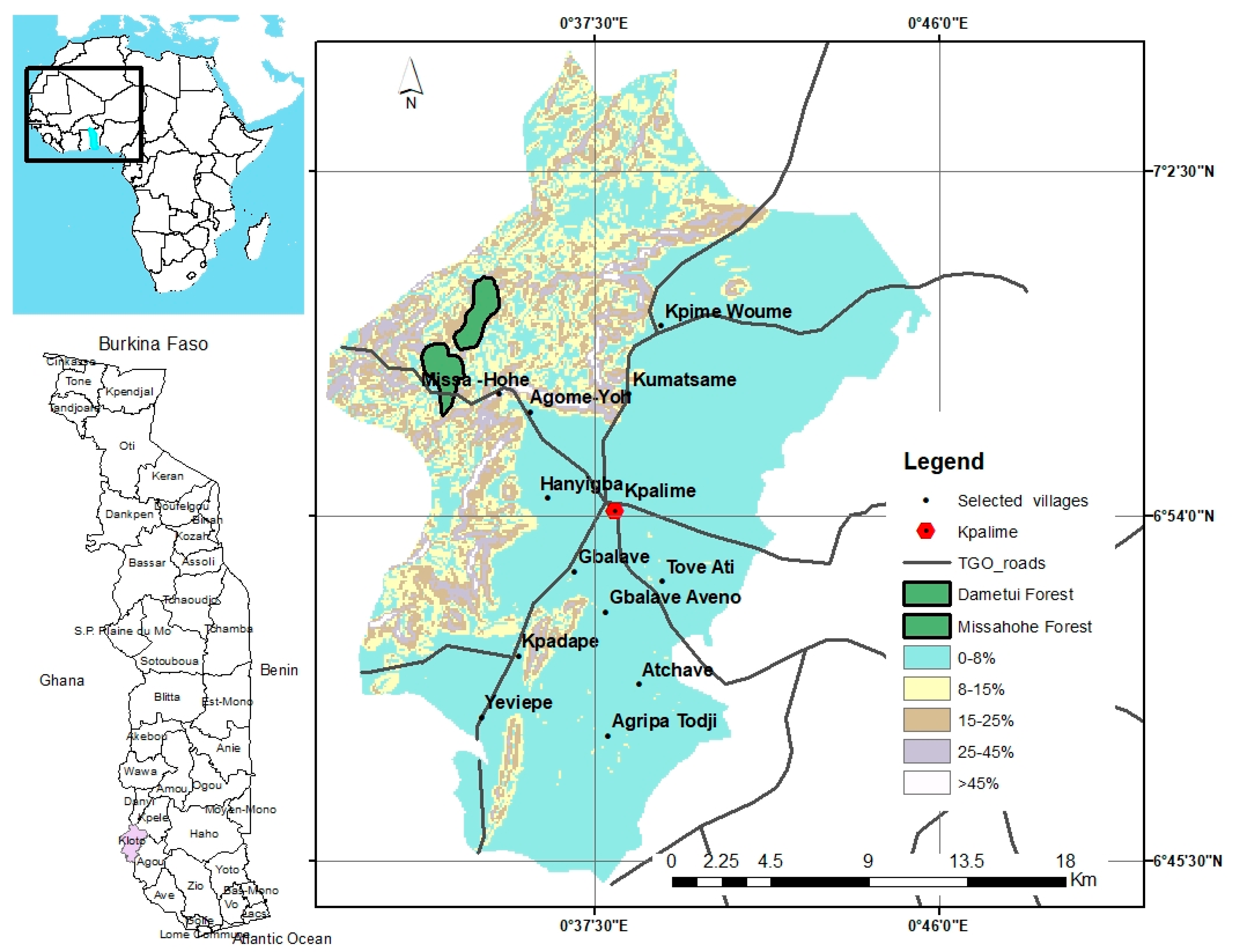
2.1. Study Area
2.2. Data Collection and Analysis
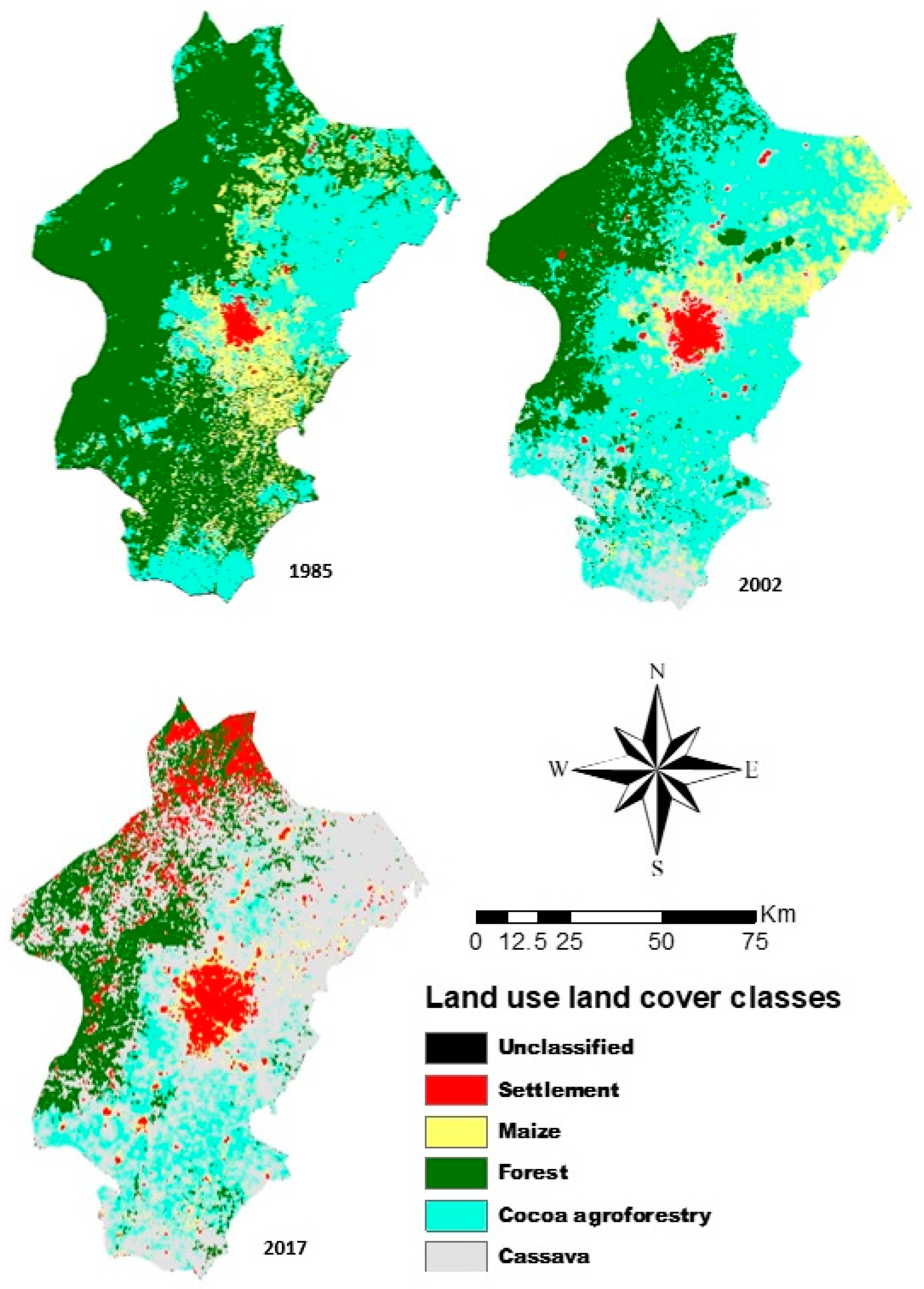
3. Results
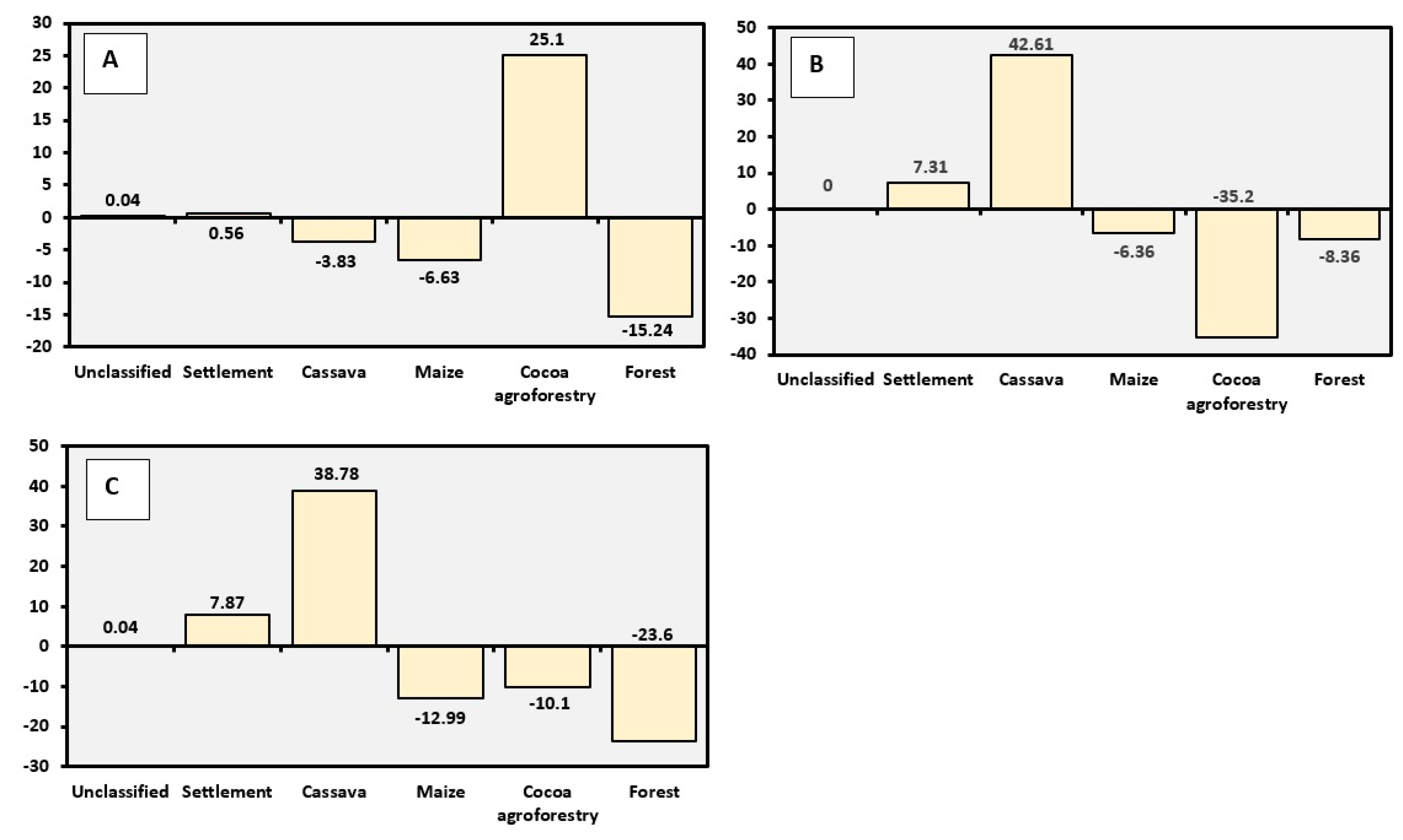
3.1. Net Change Analysis
3.2. Current Local Farming and Cropping Systems in a Changing Climate
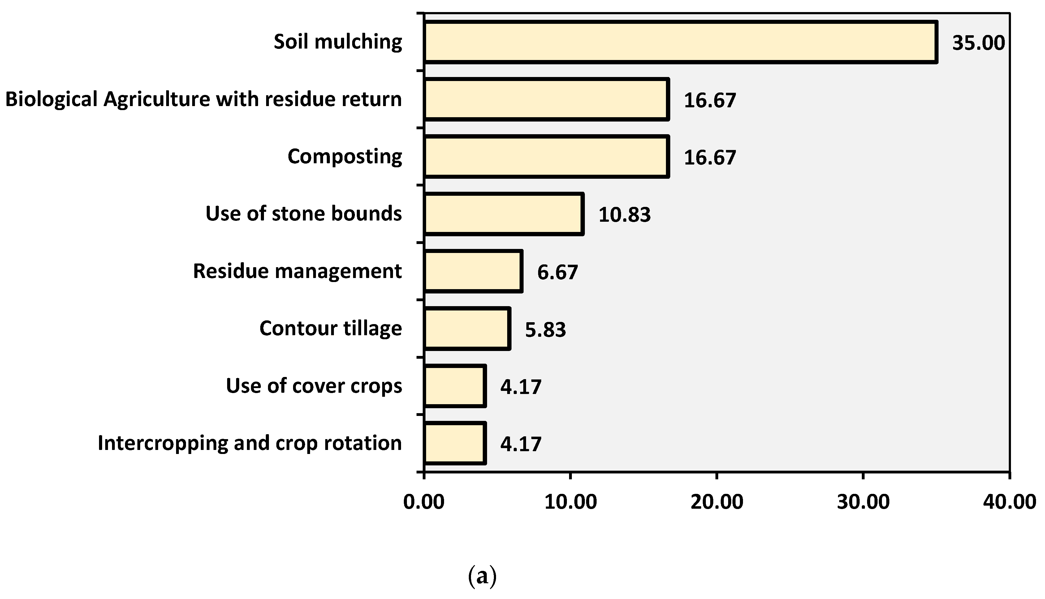
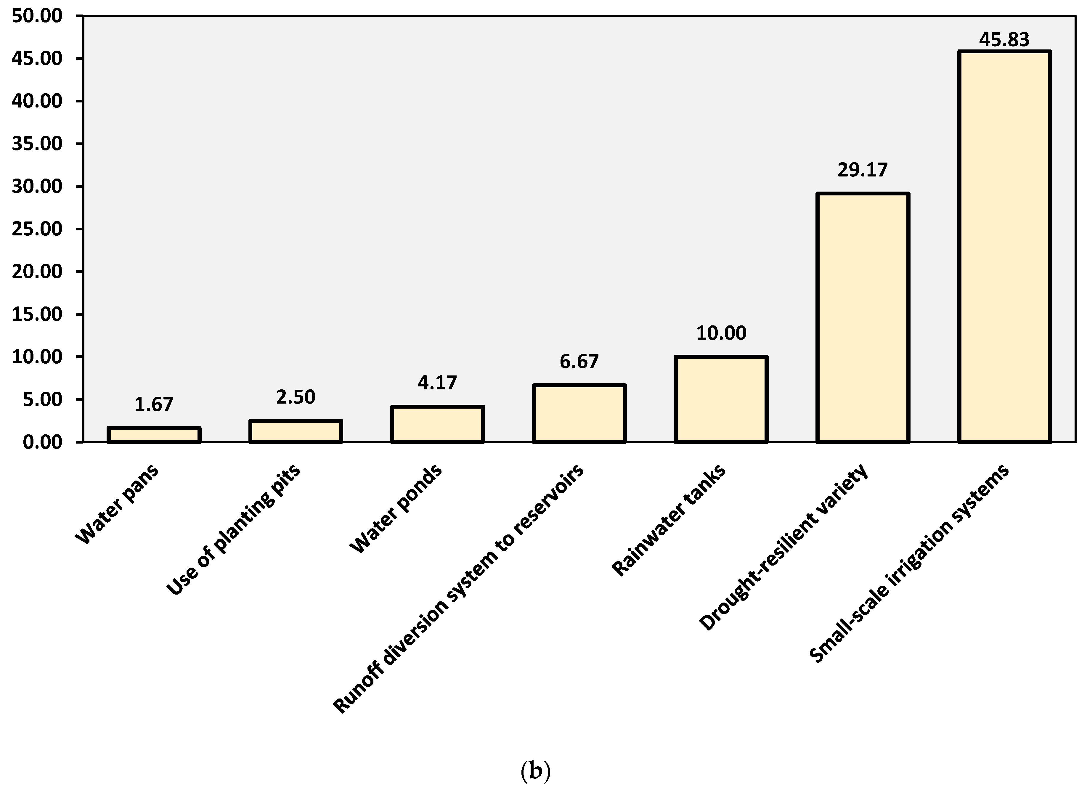
3.3. Local Willingness to Adopt Integrated Soil and Water Conservation (SWC) Practices
4. Discussion
5. Conclusions
Author Contributions
Funding
Acknowledgments
Conflicts of Interest
References
- Zhao, X. Soil Degradation through Agriculture in China: Its Extent, Impacts and Implications for Environmental Law Reform. In International Yearbook of Soil Law and Policy; Springer: Cham, Switzerland, 2017; pp. 37–63. [Google Scholar]
- Cramer, W.; Bondeau, A.; Schaphoff, S.; Lucht, W.; Smith, B.; Sitch, S. Tropical forests and the global carbon cycle: Impacts of atmospheric carbon dioxide, climate change and rate of deforestation. Philos. Trans. R. Soc. Lond. B Biol. Sci. 2004, 359, 331–343. [Google Scholar] [CrossRef] [PubMed]
- Van der Werf, G.R.; Morton, D.C.; DeFries, R.S.; Olivier, J.G.; Kasibhatla, P.S.; Jackson, R.B.; Collatz, G.J.; Randerson, J.T. CO2 emissions from forest loss. Nat. Geosci. 2009, 2, 737–738. [Google Scholar] [CrossRef]
- Saatchi, S.S.; Harris, N.L.; Brown, S.; Lefsky, M.; Mitchard, E.T.; Salas, W.; Zutta, B.R.; Buermann, W.; Lewis, S.L.; Hagen, S.; et al. Benchmark map of forest carbon stocks in tropical regions across three continents. Proc. Natl. Acad. Sci. USA 2011, 108, 9899–9904. [Google Scholar] [CrossRef] [PubMed]
- IPCC. Climate Change 2014: Synthesis Report. Contribution of Working Groups I, II and III to the Fifth Assessment Report of the Intergovernmental Panel on Climate Change; Core Writing Team, Pachauri, R.K., Meyer, L.A., Eds.; IPCC: Geneva, Switzerland, 2014; 151p. [Google Scholar]
- Moomen, A.W.; Dewan, A.; Corner, R. Landscape assessment for sustainable resettlement of potentially displaced communities in Ghana’s emerging northwest gold province. J. Clean. Prod. 2016, 133, 701–711. [Google Scholar] [CrossRef]
- Tegegne, Y.T.; Lindner, M.; Fobissie, K.; Kanninen, M. Evolution of drivers of deforestation and forest degradation in the Congo Basin forests: Exploring possible policy options to address forest loss. Land Use Policy 2016, 5, 1312–1324. [Google Scholar] [CrossRef]
- Keenan, R.J.; Reams, G.A.; Achard, F.; de Freitas, J.V.; Grainger, A.; Lindquist, E. Dynamics of global forest area: Results from the FAO Global Forest Resources Assessment 2015. For. Ecol. Manag. 2015, 352, 9–20. [Google Scholar] [CrossRef]
- Houghton, R. Tropical deforestation as a source of greenhouse gas emissions. In Tropical Deforestation and Climate Change; Instituto de Pesquisa Ambiental da Amazônia: Belém, Brazil, 2005. [Google Scholar]
- Gibbs, H.K.; Brown, S.; Niles, J.O.; Foley, J.A. Monitoring and estimating tropical forest carbon stocks: Making REDD a reality. Environ. Res. Lett. 2007, 2, 045023. [Google Scholar] [CrossRef]
- Wunder, S.; Kaphengst, T.; Frelih-Larsen, A. Implementing land degradation neutrality (SDG 15.3) at national level: General approach, indicator selection and experiences from Germany. In International Yearbook of Soil Law and Policy; Springer: Cham, Switzerland, 2017; pp. 191–219. [Google Scholar]
- Koglo, Y.S. Land Use Transition and Cropland Degradation on Forest Sustainability, Smallholders Economic and Food Self-Sufficiency under Current and Future Climate Change Scenarios in the Soudan and Guinea Savannah Zone (Togo, West Africa). Ph.D. Thesis, KNUST, Kumasi, Ghana, 2018. [Google Scholar]
- Dewan, A.M.; Yamaguchi, Y. Land use and land cover change in Greater Dhaka, Bangladesh: Using remote sensing to promote sustainable urbanization. Appl. Geogr. 2009, 29, 390–401. [Google Scholar] [CrossRef]
- Rawat, J.S.; Kumar, M. Monitoring land use/cover change using remote sensing and GIS techniques: A case study of Hawalbagh block, district Almora, Uttarakhand, India. Egypt. J. Remote Sens. Space Sci. 2015, 18, 77–84. [Google Scholar] [CrossRef]
- Rawat, J.S.; Biswas, V.; Kumar, M. Changes in land use/cover using geospatial techniques-A case study of Ramnagar town area, district Nainital, Uttarakhand, India. Egypt. J. Remote Sens. Space Sci. 2013, 16, 111–117. [Google Scholar] [CrossRef]
- Folega, F.; Zhang, C.; Zhao, X.; Wala, K.; Batawila, K.; Huang, H.G.; Dourma, M.; Akpagana, K. Satellite monitoring of land-use and land-cover changes in northern Togo protected areas. J. Forestry Res. 2014, 25, 385–392. [Google Scholar] [CrossRef]
- Badjana, H.M.; Selsam, P.; Wala, K.; Flügel, W.A.; Fink, M.; Urban, M.; Helmschrot, J.; Afouda, A.; Akpagana, K. Assessment of land-cover changes in a sub-catchment of the Oti basin (West Africa): A case study of the Kara River basin. Zentralblatt Geologie Paläontologie Teil I 2014, 1, 151–170. [Google Scholar] [CrossRef]
- Butt, A.; Shabbir, R.; Ahmad, S.S.; Aziz, N. Land use change mapping and analysis using Remote Sensing and GIS: A case study of Simly watershed, Islamabad, Pakistan. Egypt. J. Remote Sens. Space Sci. 2015, 18, 251–259. [Google Scholar] [CrossRef]
- Dimobe, K.; Ouédraogo, A.; Soma, S.; Goetze, D.; Porembski, S.; Thiombiano, A. Identification of driving factors of land degradation and deforestation in the Wildlife Reserve of Bontioli (Burkina Faso, West Africa). Glob. Ecol. Conserv. 2015, 4, 559–571. [Google Scholar] [CrossRef]
- Pontius, R.G.; Shusas, E.; Mceachern, M. Detecting important categorical land changes while accounting for persistence. Agric. Ecosyst. Environ. 2004, 101, 251–268. [Google Scholar] [CrossRef]
- Aloô, C.A.; Pontius, R.G., Jr. Identifying systematic land-cover transitions using remote sensing and GIS: The fate of forests inside and outside protected areas of Southwestern Ghana. Environ. Plan. 2008, 35, 280–296. [Google Scholar] [CrossRef]
- Gao, Y.; Pontius, R.G., Jr.; Giner, N.M.; Kohyama, T.S.; Osaki, M.; Hirose, K. Land Change Analysis from 2000 to 2004 in Peatland of Central Kalimantan, Indonesia Using GIS and an Extended Transition Matrix. In Tropical Peatland Ecosystems; Springer: Tokyo, Japan, 2016; pp. 433–443. [Google Scholar]
- Diwediga, B.; Agodzo, S.; Wala, K.; Le, Q.B. Assessment of multifunctional landscapes dynamics in the mountainous basin of the Mo River (Togo, West Africa). J. Geogr. Sci. 2017, 27, 579–605. [Google Scholar] [CrossRef]
- Herrmann, S.M.; Sall, I.; Sy, O. People and pixels in the Sahel: A study linking coarse-resolution remote sensing observations to land users’ perceptions of their changing environment in Senegal. Ecol. Soc. 2014, 19, 29. [Google Scholar] [CrossRef]
- Liverman, D.M.; Cuesta, R.M.R. Human interactions with the earth system: People and pixels revisited. Earth Surf. Process. Landf. 2008, 33, 1458–1471. [Google Scholar] [CrossRef]
- FAO. Guidelines for Land-Use Planning; FAO Development Series 1; FAO: Rome, Italy, 1993; Available online: www.fao.org/ docrep/t0715e/t0715e00.htm (accessed on 12 May 2018).
- FAO. Global Forest Resources Assessment 2010; FAO: Rome, Italy, 2010; Available online: www.fao.org/docrep/013/i1757e/i1757e.pdf (accessed on 12 May 2018).
- FAO. State of the World’s Forests 2016. Forests and Agriculture: Land-Use Challenges and Opportunities; FAO: Rome, Italy, 2016; p. 126. [Google Scholar]
- IPCC. Guidelines for National Greenhouse Gas Inventories; IPCC: Geneva, Switzerland, 2006; Available online: www.ipcc.org (accessed on 20 February 2018).
- Kissinger, G.; Herold, M.; de Sy, V. Drivers of Deforestation and Forest Degradation: A Synthesis Report for REDD+ Policymakers; Lexeme Consulting: Vancouver, BC, Canada, 2012; 48p. [Google Scholar]
- Moomen, A.W.; Dewan, A. Assessing the spatial relationships between mining and land degradation: Evidence from Ghana. Int. J. Min. Reclam. Environ. 2017, 31, 505–518. [Google Scholar] [CrossRef]
- Callo-Concha, D.; Gaiser, T.; Webber, H.; Tischbein, B.; Müller, M.; Ewert, F. Farming in the West African Sudan Savanna: Insights in the context of climate change. Afr. J. Agric. Res. 2013, 8, 4693–4705. [Google Scholar] [CrossRef]


| Land Use Land Cover Type | Definition | Source |
|---|---|---|
| Forest | Areas covered with original vegetation of different tree species of a minimum height of 5 m at maturity and 30% maximum crown cover with 0.5 ha minimum area spanning. | [29] |
| Cocoa agroforestry | Perennial arable and tillable land of mixing cocoa, trees and other crops (plantains) under conventional and family cropping systems. | Authors’ definitions |
| Cassava | Annual/perennial arable and tillable land of local or improved cassava under conventional and family cropping systems. | |
| Maize | Annually tilled lands for cropping improved maize varieties (Ikenne or Obatanpa) under conventional family cropping systems. | |
| Settlement | Areas covered with human habitations where tree cover is negligible. | |
| Other | Places occupied by, e.g., road, water. |
| 1985 | 2002 | 2017 | ||||
|---|---|---|---|---|---|---|
| Km2 | % | km2 | % | km2 | % | |
| Unclassified | 0.54 | 0.10 | 0.75 | 0.14 | 0.72 | 0.14 |
| Settlement | 8.29 | 1.57 | 11.24 | 2.13 | 49.89 | 9.44 |
| Cassava | 75.03 | 14.37 | 54.76 | 10.37 | 279.85 | 52.98 |
| Maize | 84.46 | 15.96 | 49.42 | 9.36 | 15.86 | 3.00 |
| Cocoa agroforestry | 133.52 | 25.23 | 266.14 | 50.38 | 80.16 | 15.18 |
| Forest | 226.37 | 42.78 | 145.92 | 27.62 | 101.74 | 19.26 |
| Total | 528.21 | 100.00 | 528.23 | 100.00 | 528.22 | 100.00 |
© 2018 by the authors. Licensee MDPI, Basel, Switzerland. This article is an open access article distributed under the terms and conditions of the Creative Commons Attribution (CC BY) license (http://creativecommons.org/licenses/by/4.0/).
Share and Cite
Koglo, Y.S.; Agyare, W.A.; Diwediga, B.; Sogbedji, J.M.; Adden, A.K.; Gaiser, T. Remote Sensing-Based and Participatory Analysis of Forests, Agricultural Land Dynamics, and Potential Land Conservation Measures in Kloto District (Togo, West Africa). Soil Syst. 2018, 2, 49. https://doi.org/10.3390/soilsystems2030049
Koglo YS, Agyare WA, Diwediga B, Sogbedji JM, Adden AK, Gaiser T. Remote Sensing-Based and Participatory Analysis of Forests, Agricultural Land Dynamics, and Potential Land Conservation Measures in Kloto District (Togo, West Africa). Soil Systems. 2018; 2(3):49. https://doi.org/10.3390/soilsystems2030049
Chicago/Turabian StyleKoglo, Yawovi S., Wilson A. Agyare, Badabate Diwediga, Jean M. Sogbedji, Ayi K. Adden, and Thomas Gaiser. 2018. "Remote Sensing-Based and Participatory Analysis of Forests, Agricultural Land Dynamics, and Potential Land Conservation Measures in Kloto District (Togo, West Africa)" Soil Systems 2, no. 3: 49. https://doi.org/10.3390/soilsystems2030049
APA StyleKoglo, Y. S., Agyare, W. A., Diwediga, B., Sogbedji, J. M., Adden, A. K., & Gaiser, T. (2018). Remote Sensing-Based and Participatory Analysis of Forests, Agricultural Land Dynamics, and Potential Land Conservation Measures in Kloto District (Togo, West Africa). Soil Systems, 2(3), 49. https://doi.org/10.3390/soilsystems2030049