

Characterization of Fuel Types for the Canadian Region Using MODIS MCD12Q1 Data


Abstract
1. Introduction
2. Materials and Method
2.1. Study Area
2.2. Data
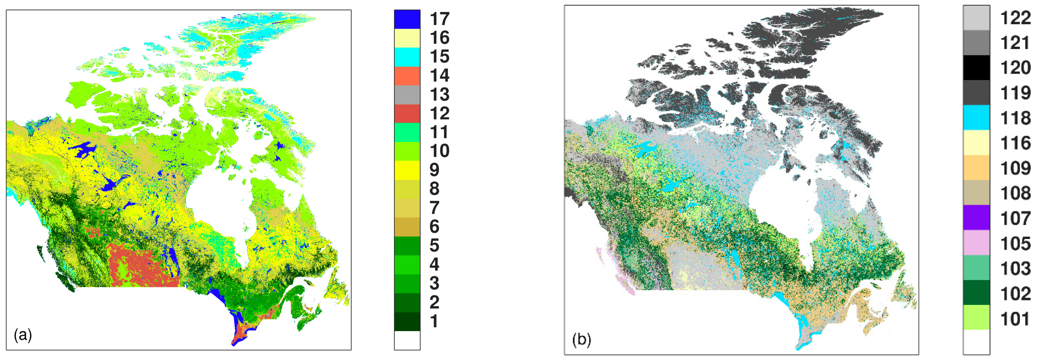
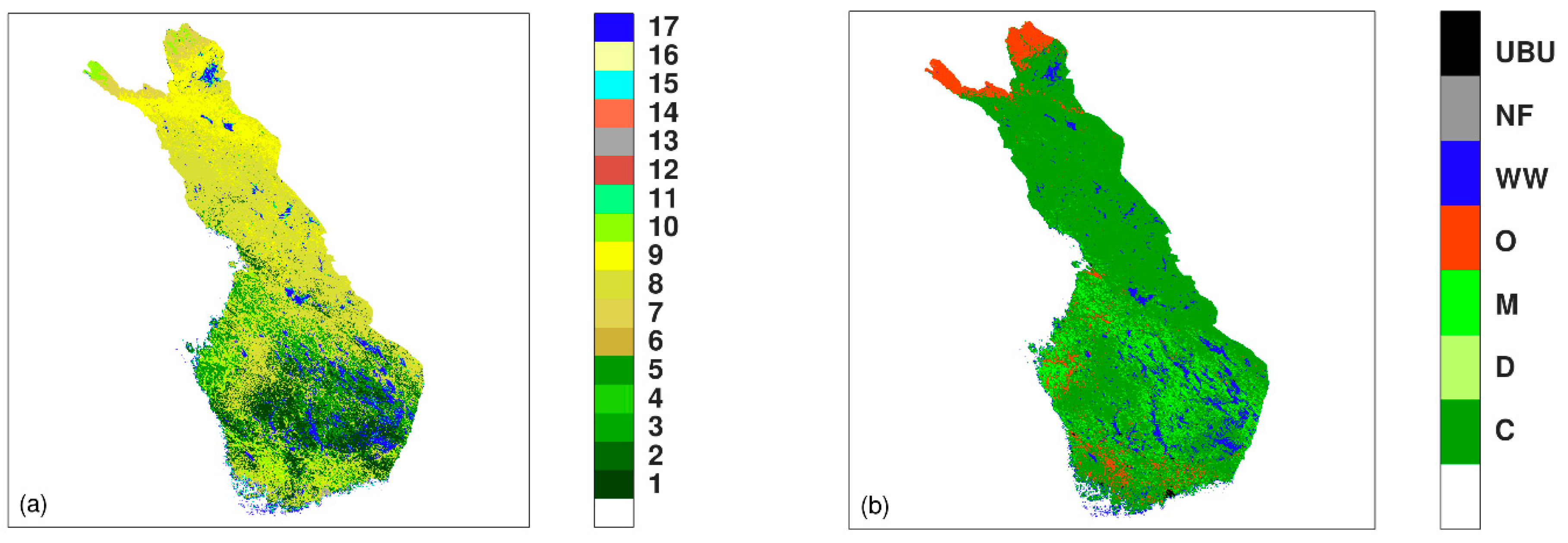
2.2.1. Canadian Land Cover Map from MODIS MCD12Q1
2.2.2. Canadian Fuel-Type Map from CWFIS
2.3. Pre-Processing
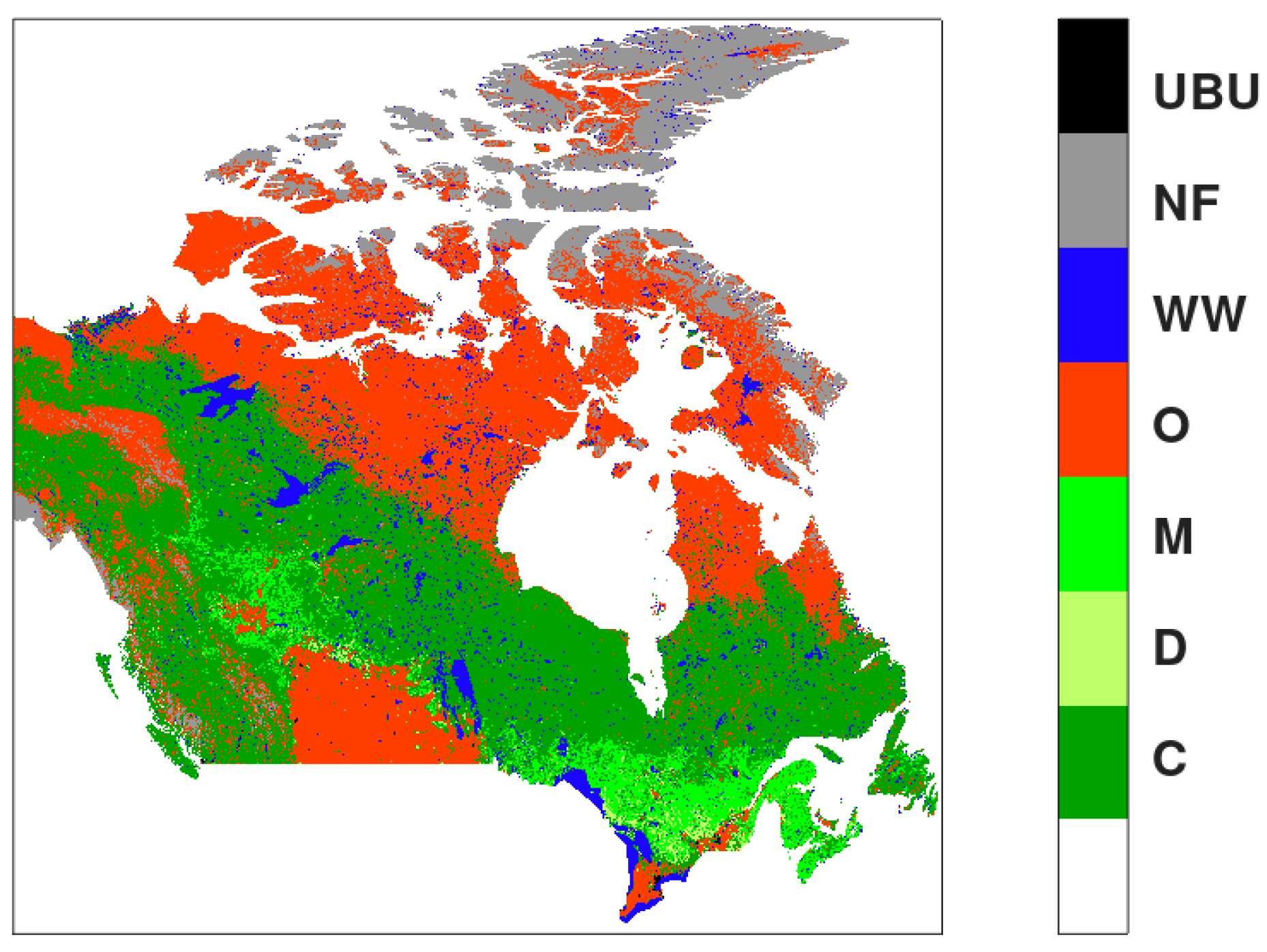
2.4. Processing: Ambiguity Removal, Counting Data Matrix, and Confusion Matrix
2.5. Confusion Matrix and Analysis of Accuracy
3. Results and Discussion
- MODIS LCM classes 1, 2, 8, 9, and 11 were associated with FBP FTM classes 101, 102, 103, 105, and 107 in fuel type Coniferous (C);
- MODIS LCM classes 4 and 6 were associated with FBP FTM class 108 in fuel type Deciduous (D);
- MODIS LCM classes 3 and 5 were associated with FBP FTM class 109 in fuel type Mixedwood (M);
- MODIS LCM 7, 10, 12, and 14 were associated with FBP FTM classes 116 and 122 in fuel type Open (O);
- MODIS LCM class 17 was associated with FBP FTM classes 118 and 120 in fuel type Water and Wetland (WW);
- MODIS LCM classes 15 and 16 were associated with FBP FTM class 119 in fuel type No-Fuel (NF);
- MODIS LCM class 13 was associated with FBP FTM classes 116 and 122 in fuel type Urban and Built-Up area (UBU).
4. Conclusions
Author Contributions
Funding
Data Availability Statement
Acknowledgments
Conflicts of Interest
References
- Lasslop, G.; Hantson, S.; Harrison, S.P.; Bachelet, D.; Burton, C.; Forkel, M.; Forrest, M.; Li, F.; Melton, J.R.; Yue, C.; et al. Global Ecosystems and Fire: Multi-Model Assessment of Fire-Induced Tree-Cover and Carbon Storage Reduction. Glob. Chang. Biol. 2020, 26, 5027–5041. [Google Scholar] [CrossRef] [PubMed]
- Bowman, D.M.J.S.; Balch, J.; Artaxo, P.; Bond, W.J.; Cochrane, M.A.; D’Antonio, C.M.; DeFries, R.; Johnston, F.H.; Keeley, J.E.; Krawchuk, M.A.; et al. The Human Dimension of Fire Regimes on Earth: The Human Dimension of Fire Regimes on Earth. J. Biogeogr. 2011, 38, 2223–2236. [Google Scholar] [CrossRef] [PubMed]
- Mccaffrey, S. Thinking of Wildfire as a Natural Hazard. Soc. Nat. Resour. 2004, 17, 509–516. [Google Scholar] [CrossRef]
- Tyukavina, A.; Potapov, P.; Hansen, M.C.; Pickens, A.H.; Stehman, S.V.; Turubanova, S.; Parker, D.; Zalles, V.; Lima, A.; Kommareddy, I.; et al. Global Trends of Forest Loss Due to Fire from 2001 to 2019. Front. Remote Sens. 2022, 3, 825190. [Google Scholar] [CrossRef]
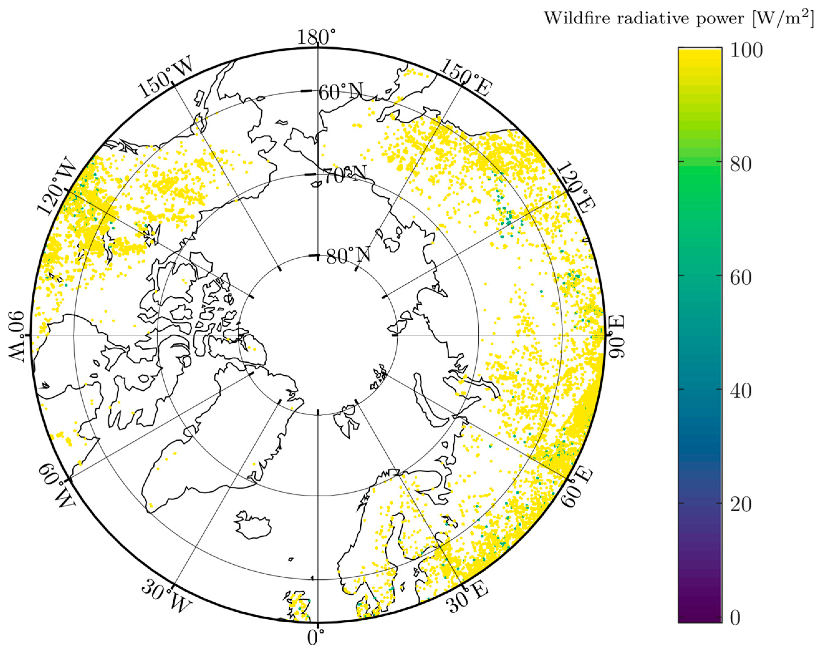
- Descals, A.; Gaveau, D.L.A.; Verger, A.; Sheil, D.; Naito, D.; Peñuelas, J. Unprecedented Fire Activity above the Arctic Circle Linked to Rising Temperatures. Science 2022, 378, 532–537. [Google Scholar] [CrossRef]
- Justino, F.; Bromwich, D.; Wilson, A.; Silva, A.; Avila-Diaz, A.; Fernandez, A.; Rodrigues, J. Estimates of Temporal-Spatial Variability of Wildfire Danger across the Pan-Arctic and Extra-Tropics. Environ. Res. Lett. 2021, 16, 044060. [Google Scholar] [CrossRef]
- Arroyo, L.A.; Pascual, C.; Manzanera, J.A. Fire Models and Methods to Map Fuel Types: The Role of Remote Sensing. For. Ecol. Manag. 2008, 256, 1239–1252. [Google Scholar] [CrossRef]
- Gale, M.G.; Cary, G.J.; Van Dijk, A.I.J.M.; Yebra, M. Forest Fire Fuel through the Lens of Remote Sensing: Review of Approaches, Challenges and Future Directions in the Remote Sensing of Biotic Determinants of Fire Behaviour. Remote Sens. Environ. 2021, 255, 112282. [Google Scholar] [CrossRef]
- Or, D.; Furtak-Cole, E.; Berli, M.; Shillito, R.; Ebrahimian, H.; Vahdat-Aboueshagh, H.; McKenna, S.A. Review of Wildfire Modeling Considering Effects on Land Surfaces. Earth Sci. Rev. 2023, 245, 104569. [Google Scholar] [CrossRef]
- Aragoneses, E.; Chuvieco, E. Generation and Mapping of Fuel Types for Fire Risk Assessment. Fire 2021, 4, 59. [Google Scholar] [CrossRef]
- Abdollahi, A.; Yebra, M. Forest Fuel Type Classification: Review of Remote Sensing Techniques, Constraints and Future Trends. J. Environ. Manag. 2023, 342, 118315. [Google Scholar] [CrossRef]
- Stocks, B.J.; Lynham, T.J.; Lawson, B.D.; Alexander, M.E.; Wagner, C.E.V.; McAlpine, R.S.; Dubé, D.E. Canadian Forest Fire Danger Rating System: An Overview. For. Chron. 1989, 65, 258–265. [Google Scholar] [CrossRef]
- Coogan, S.C.P.; Daniels, L.D.; Boychuk, D.; Burton, P.J.; Flannigan, M.D.; Gauthier, S.; Kafka, V.; Park, J.S.; Wotton, B.M. Fifty Years of Wildland Fire Science in Canada. Can. J. For. Res. 2021, 51, 283–302. [Google Scholar] [CrossRef]
- CWFGM Steering Committee Prometheus User Manual v. 3.0.1; Canadian Forest Service: Ottawa, ON, Canada, 2004; Available online: https://prometheus.io/docs/introduction/overview/ (accessed on 3 December 2024).
- Hirsch, K.G. Canadian Forest Fire Behavior Prediction (FBP) System: User’s Guide; Natural Resources Canada: Ottawa, ON, Canada; Canadian Forest Service: Ottawa, ON, Canada; Northern Forestry Centre: Edmonton, AB, Canada, 1996. [Google Scholar]
- Forestry Canada Fire Danger Group (FCFDG). Development and Structure of the Canadian Forest Fire Behavior Prediction System; Information Report ST-X-3; Forestry Canada: Ottawa, ON, Canada, 1992; 64p, Available online: https://cfs.nrcan.gc.ca/publications?id=10068 (accessed on 3 December 2024).
- Aragoneses, E.; García, M.; Salis, M.; Ribeiro, L.M.; Chuvieco, E. Classification and Mapping of European Fuels Using a Hierarchical, Multipurpose Fuel Classification System. Earth Syst. Sci. Data 2023, 15, 1287–1315. [Google Scholar] [CrossRef]
- Chuvieco, E.; Wagtendonk, J.; Riaño, D.; Yebra, M.; Ustin, S.L. Estimation of Fuel Conditions for Fire Danger Assessment. In Earth Observation of Wildland Fires in Mediterranean Ecosystems; Chuvieco, E., Ed.; Springer: Berlin/Heidelberg, Germany, 2009; pp. 83–96. ISBN 978-3-642-01753-7. [Google Scholar]
- Marino, E.; Ranz, P.; Tomé, J.L.; Noriega, M.Á.; Esteban, J.; Madrigal, J. Generation of High-Resolution Fuel Model Maps from Discrete Airborne Laser Scanner and Landsat-8 OLI: A Low-Cost and Highly Updated Methodology for Large Areas. Remote Sens. Environ. 2016, 187, 267–280. [Google Scholar] [CrossRef]
- Chrysafis, I.; Damianidis, C.; Giannakopoulos, V.; Mitsopoulos, I.; Dokas, I.M.; Mallinis, G. Vegetation Fuel Mapping at Regional Scale Using Sentinel-1, Sentinel-2, and DEM Derivatives—The Case of the Region of East Macedonia and Thrace, Greece. Remote Sens. 2023, 15, 1015. [Google Scholar] [CrossRef]
- Domingo, D.; De La Riva, J.; Lamelas, M.; García-Martín, A.; Ibarra, P.; Echeverría, M.; Hoffrén, R. Fuel Type Classification Using Airborne Laser Scanning and Sentinel 2 Data in Mediterranean Forest Affected by Wildfires. Remote Sens. 2020, 12, 3660. [Google Scholar] [CrossRef]
- Li, Z.; Chen, X.; Qi, J.; Xu, C.; An, J.; Chen, J. Accuracy Assessment of Land Cover Products in China from 2000 to 2020. Sci. Rep. 2023, 13, 12936. [Google Scholar] [CrossRef]
- Pettinari, M.L.; Chuvieco, E. Fire Danger Observed from Space. Surv. Geophys. 2020, 41, 1437–1459. [Google Scholar] [CrossRef]
- Carbone, A.; Spiller, D.; Laneve, G. Fuel Type Mapping Using a CNN-Based Remote Sensing Approach: A Case Study in Sardinia. Fire 2023, 6, 395. [Google Scholar] [CrossRef]
- Liang, D.; Zuo, Y.; Huang, L.; Zhao, J.; Teng, L.; Yang, F. Evaluation of the Consistency of MODIS Land Cover Product (MCD12Q1) Based on Chinese 30 m GlobeLand30 Datasets: A Case Study in Anhui Province, China. ISPRS Int. J. Geo Inf. 2015, 4, 2519–2541. [Google Scholar] [CrossRef]
- Wang, H.; Wen, X.; Wang, Y.; Cai, L.; Peng, D.; Liu, Y. China’s Land Cover Fraction Change during 2001–2015 Based on Remote Sensed Data Fusion between MCD12 and CCI-LC. Remote Sens. 2021, 13, 341. [Google Scholar] [CrossRef]
- DeCastro, A.L.; Juliano, T.W.; Kosović, B.; Ebrahimian, H.; Balch, J.K. A Computationally Efficient Method for Updating Fuel Inputs for Wildfire Behavior Models Using Sentinel Imagery and Random Forest Classification. Remote Sens. 2022, 14, 1447. [Google Scholar] [CrossRef]
- Tymstra, C.; Bryce, R.W.; Wotton, B.M.; Taylor, S.W.; Armitage, O.B. Development and Structure of Prometheus: The Canadian Wildland Fire Growth Simulation Model; Northern Forestry Centre: Edmonton, AB, Canada, 2010. [Google Scholar]
- Seto, D.; Jones, C.; Trugman, A.T.; Varga, K.; Plantinga, A.J.; Carvalho, L.M.V.; Thompson, C.; Gellman, J.; Daum, K. Simulating Potential Impacts of Fuel Treatments on Fire Behavior and Evacuation Time of the 2018 Camp Fire in Northern California. Fire 2022, 5, 37. [Google Scholar] [CrossRef]
- Redpath, T.; Nogarin, F.; Bryce, R.; Brett, M. Wildfire Intelligence and Simulation Engine (WISE). Available online: https://Github.Com/WISE-Developers/WISE_Application (accessed on 1 July 2024).
- Dastour, H.; Ahmed, M.R.; Hassan, Q.K. Analysis of Forest Fire Patterns and Their Relationship with Climate Variables in Alberta’s Natural Subregions. Ecol. Inform. 2024, 80, 102531. [Google Scholar] [CrossRef]
- Baldwin, K.; Allen, L.; Basquill, S.; Chapman, K.; Downing, D.; Flynn, N.; MacKenzie, W.; Major, M.; Meades, W.; Meidinger, D.; et al. Vegetation Zones of Canada: A Biogeoclimatic Perspective; Canadian Forest Service Great Lakes Forestry Centre: Sault Ste. Marie, ON, Canada, 2020. [Google Scholar]
- Ricketts, T. Terrestrial Ecoregions of North America: A Conservation Assessment; Island Press: Washington, DC, USA, 1999. [Google Scholar]
- Majasalmi, T.; Rautiainen, M. Representation of Tree Cover in Global Land Cover Products: Finland as a Case Study Area. Environ. Monit. Assess. 2021, 193, 121. [Google Scholar] [CrossRef]
- Sulla-Menashe, D.; Friedl, M.A. User Guide to Collection 6 MODIS Land Cover (MCD12Q1 and MCD12C1) Product. User Guides. NASA EOSDIS Land Process DAAC 2018, 6, 1–18. [Google Scholar]
- Beaudoin, A.; Bernier, P.Y.; Guindon, L.; Villemaire, P.; Guo, X.J.; Stinson, G.; Bergeron, T.; Magnussen, S.; Hall, R.J. Mapping Attributes of Canada’s Forests at Moderate Resolution through k NN and MODIS Imagery. Can. J. For. Res. 2014, 44, 521–532. [Google Scholar] [CrossRef]
- Taylor, S.; Pike, R.G.; Alexander, M.E. Field Guide to the Canadian Forest Fire Behavior Prediction (FBP) System, 3rd ed.; Natural Resources Canada: Ottawa, ON, Canada; Canadian Forest Service: Ottawa, ON, Canada; Northern Forestry Centre: Edmonton, AB, Canada, 1996; Available online: https://ostrnrcan-dostrncan.canada.ca/entities/publication/edc927d6-dd86-4c1a-a146-e69859e7c93f (accessed on 7 March 2024).
- Wotton, B.M.; Alexander, M.; Taylor, S.W. Updates and Revisions to the 1992 Canadian Forest Fire Behavior Prediction System; Information Report GLC-X-10; Great Lakes Forestry Centre: Sault Ste. Marie, ON, Canada, 2009; Available online: https://publications.gc.ca/collections/collection_2010/nrcan/Fo123-2-10-2009-eng.pdf (accessed on 12 December 2023).
- GDAL/OGR Contributors GDAL/OGR Geospatial Data Abstraction Software Library. Open Source Geospatial Foundation. Available online: https://gdal.org (accessed on 3 February 2024).
- Congalton, R.G. A Review of Assessing the Accuracy of Classifications of Remotely Sensed Data. Remote Sens. Environ. 1991, 37, 35–46. [Google Scholar] [CrossRef]
- Stehman, S.V. Selecting and Interpreting Measures of Thematic Classification Accuracy. Remote Sens. Environ. 1997, 62, 77–89. [Google Scholar] [CrossRef]
- Simpson, B.; Englefield, P.; Anderson, K. Fuel-Type Mapping for the CWFIS: Past, Present, and Future. Can. Smoke Newsl. 2010, 2010, 4–9. [Google Scholar]
- Fowler, N.L.; Beckage, B. Savannas of North America. In Savanna Woody Plants and Large Herbivores; John Wiley & Sons, Ltd.: Hoboken, NJ, USA, 2019; pp. 123–150. ISBN 978-1-119-08111-1. [Google Scholar]
- Pouliot, D.; Latifovic, R.; Zabcic, N.; Guindon, L.; Olthof, I. Development and Assessment of a 250 m Spatial Resolution MODIS Annual Land Cover Time Series (2000–2011) for the Forest Region of Canada Derived from Change-Based Updating. Remote Sens. Environ. 2014, 140, 731–743. [Google Scholar] [CrossRef]
- Kennedy, G.; Mayer, T. Natural and Constructed Wetlands in Canada: An Overview. Water Qual. Res. J. 2002, 37, 295–325. [Google Scholar] [CrossRef]
- Zoltai, S.C.; Vitt, D.H. Canadian Wetlands: Environmental Gradients and Classification. Vegetatio 1995, 118, 131–137. [Google Scholar] [CrossRef]
- Rein, G.; Huang, X. Smouldering Wildfires in Peatlands, Forests and the Arctic: Challenges and Perspectives. Curr. Opin. Environ. Sci. Health 2021, 24, 100296. [Google Scholar] [CrossRef] [PubMed]
- Anderson, J.R.; Hardy, E.E.; Roach, J.T.; Witmer, R.E. A Land Use and Land Cover Classification System for Use with Remote Sensor Data; USGS Numbered Series; US Government Printing Office: Washington, DC, USA, 1976; Geological Survey Professional Paper 964. [CrossRef]
- Landis, J.R.; Koch, G.G. The Measurement of Observer Agreement for Categorical Data. Biometrics 1977, 33, 159. [Google Scholar] [CrossRef]
- Aragoneses, E.; Garcia, M.; Chuvieco, E. FirEUrisk_Europe_fuel_map: European Fuel Map at 1 Km Resolution; e-cienciaDatos, V2; Universidad de Alcalá: Madrid, Spain, 2022. [Google Scholar] [CrossRef]
- Eurostat. Land Use/Cover Area Frame Survey (LUCAS). 2018. Available online: https://ec.europa.eu/eurostat/web/lucas/overview (accessed on 13 December 2024).
- Sismanis, M.; Gitas, I.Z.; Stavrakoudis, D.; Georgopoulos, N.; Antoniadis, K.; Gkounti, E. A Novel Spectral–Spatial Methodology for Hierarchical Fuel Type Mapping in Mediterranean Ecosystems Using Sentinel-2 Timeseries and Auxiliary Thematic Data. Fire 2024, 7, 407. [Google Scholar] [CrossRef]
- Smith, C.W.; Panda, S.K.; Bhatt, U.S.; Meyer, F.J. Improved Boreal Forest Wildfire Fuel Type Mapping in Interior Alaska Using AVIRIS-NG Hyperspectral Data. Remote Sens. 2021, 13, 897. [Google Scholar] [CrossRef]
- Scott, J.H.; Burgan, R.E. Standard Fire Behavior Fuel Models: A Comprehensive Set for Use with Rothermel’s Surface Fire Spread Model; US Department of Agriculture: Washington, DC, USA, 2005; RMRS-GTR-153. [CrossRef]
- Salis, M.; Arca, B.; Alcasena, F.; Arianoutsou, M.; Bacciu, V.; Duce, P.; Duguy, B.; Koutsias, N.; Mallinis, G.; Mitsopoulos, I.; et al. Predicting Wildfire Spread and Behaviour in Mediterranean Landscapes. Int. J. Wildland Fire 2016, 25, 1015–1032. [Google Scholar] [CrossRef]
- Scherer-Lorenzen, M.; Körner, C.; Schulze, E.-D. (Eds.) Forest Diversity and Function. Temperate and Boreal System; Ecological Studies; Springer: Berlin/Heidelberg, 2005; Volume 176, ISBN 978-3-540-22191-3. [Google Scholar] [CrossRef]
- Shugart, H.H.; Leemans, R.; Bonan, G.B. A Systems Analysis of the Global Boreal Forest; Cambridge University Press: Cambridge, UK, 1992; ISBN 978-0-521-40546-1. [Google Scholar]
- de Groot, W.J.; Cantin, A.S.; Flannigan, M.D.; Soja, A.J.; Gowman, L.M.; Newbery, A. A Comparison of Canadian and Russian Boreal Forest Fire Regimes. For. Ecol. Manag. 2013, 294, 23–34. [Google Scholar] [CrossRef]
- Rogers, B.M.; Soja, A.J.; Goulden, M.L.; Randerson, J.T. Influence of Tree Species on Continental Differences in Boreal Fires and Climate Feedbacks. Nat. Geosci. 2015, 8, 228–234. [Google Scholar] [CrossRef]
- Burgan, R.; Rothermel, R. BEHAVE: Fire Behavior Prediction and Fuel Modeling System—FUEL Subsystem; General Technical Report; USDA Forest Service: Washington, DC, USA, 1984; pp. 1–126. [CrossRef]
- Volokitina, A.; Sofronova, T.; Korets, M. Vegetation Fire Behavior Prediction in Russia. In Wood and Fire Safety; Spring: Berlin/Heidelberg, Germany, 2020; pp. 379–385. [Google Scholar] [CrossRef]
- Volokitina, A.; Sofronova, T.; Korets, M. Methods of Creating Information Databases for Vegetation Fire Behavior Prediction. Eng 2022, 3, 620–634. [Google Scholar] [CrossRef]
- Vázquez-Varela, C.; Martínez-Navarro, J.M.; Abad-González, L. Traditional Fire Knowledge: A Thematic Synthesis Approach. Fire 2022, 5, 47. [Google Scholar] [CrossRef]
- Christianson, A.C.; Sutherland, C.R.; Moola, F.; Gonzalez Bautista, N.; Young, D.; MacDonald, H. Centering Indigenous Voices: The Role of Fire in the Boreal Forest of North America. Curr. For. Rep. 2022, 8, 257–276. [Google Scholar] [CrossRef]


| Code | Description |
|---|---|
| 1 | Evergreen Needleleaf Forests: dominated by evergreen conifer trees (canopy > 2 m). Tree cover > 60%. Almost all trees remain green all year. Canopy is never without green foliage. |
| 2 | Evergreen Broadleaf Forests: dominated by evergreen broadleaf and palmate trees (canopy > 2 m). Tree cover > 60%. Almost all trees and shrubs remain green year round. Canopy is never without green foliage. |
| 3 | Deciduous Needleleaf Forests: dominated by deciduous needleleaf (larch) trees (canopy > 2 m). Tree cover > 60%. Consists of seasonal needleleaf tree communities with an annual cycle of leaf-on and leaf-off periods. |
| 4 | Deciduous Broadleaf Forests: dominated by deciduous broadleaf trees (canopy > 2 m). Tree cover > 60%. Consists of broadleaf tree communities with an annual cycle of leaf-on and leaf-off periods. |
| 5 | Mixed Forests: dominated by neither deciduous nor evergreen (40–60% of each) tree types (canopy > 2 m). Tree cover > 60%. Consists of tree communities with interspersed mixtures or mosaics of the other four forest types. None of the forest types exceeds 60% of landscape. |
| 6 | Closed Shrublands: dominated by woody perennials (1–2 m height), >60% cover. The shrub foliage can be either evergreen or deciduous. |
| 7 | Open Shrublands: dominated by woody perennials (1–2 m height), 10–60% cover. The shrub foliage can be either evergreen or deciduous. |
| 8 | Woody Savannas: tree cover, 30–60% (canopy > 2 m). |
| 9 | Savannas: tree cover, 10–30% (canopy > 2 m). |
| 10 | Grasslands: dominated by herbaceous annuals (<2 m). Tree and shrub cover is less than 10%. |
| 11 | Permanent Wetlands: permanently inundated lands with 30–60% water cover and >10% vegetated cover. |
| 12 | Croplands: at least 60% of area is cultivated cropland. |
| 13 | Urban and Built-up Lands: at least 30% impervious surface area including building materials, asphalt, and vehicles. |
| 14 | Cropland/Natural Vegetation Mosaics: mosaics of small-scale cultivation 40–60% with natural tree, shrub, or herbaceous vegetation. |
| 15 | Permanent Snow and Ice: at least 60% of area is covered by snow and ice for at least 10 months of the year. |
| 16 | Barren: at least 60% of area is non-vegetated barren (sand, rock, soil) areas with less than 10% vegetation. |
| 17 | Water Bodies: at least 60% of area is covered by permanent water bodies. |
| 255 | Has not received a map label because of missing inputs |
| Code | FBP Fuel Type | Description |
|---|---|---|
| 101 | C1 | Spruce–Lichen Woodland |
| 102 | C2 | Boreal Spruce |
| 103 | C3 | Mature Jack or Lodgepole Pine |
| 104 | C4 | Immature Jack or Lodgepole Pine |
| 105 | C5 | Red and White Pine |
| 106 | C6 | Conifer Plantation |
| 107 | C7 | Ponderosa Pine–Douglas Fir |
| 108 | D1 | Leafless Aspen |
| 109 | M1 | Boreal Mixedwood–Leafless |
| 110 | M2 | Boreal Mixedwood–Green |
| 111 | M3 | Dead Balsam Fir Mixedwood–Leafless |
| 112 | M4 | Dead Balsam Fir Mixedwood–Green |
| 113 | S1 | Jack or Lodgepole Pine Slash |
| 114 | S2 | White Spruce–Balsam Slash |
| 115 | S3 | Coastal Cedar–Hemlock–Douglas |
| 116 | O1a | Matted Grass |
| 117 | O1b | Standing Grass |
| 118 | Water | Water |
| 119 | Non-Fuel | Non-Fuel |
| 120 | Unknown | Wetland (FBP fuel-type unknown) |
| 121 | Urban or Built-Up Area | Urban or Built-Up Area |
| 122 | Vegetated Non-Fuel | Vegetated Non-Fuel |
| Truth | ||||||
|---|---|---|---|---|---|---|
| Red | Green | Blue | Orange | Total | ||
| Predicted | cyan | 0 | 0 | 36 | 18 | 54 |
| magenta | 9 | 0 | 0 | 0 | 9 | |
| yellow | 0 | 9 | 0 | 0 | 9 | |
| Total | 9 | 9 | 36 | 18 | 72 | |
| Truth | |||||
|---|---|---|---|---|---|
| Blue + Orange | Red | Green | Total | ||
| Predicted | cyan | 54 | 0 | 0 | 54 |
| magenta | 0 | 9 | 0 | 9 | |
| yellow | 0 | 0 | 9 | 9 | |
| Total | 54 | 9 | 9 | 72 | |
| 101 | 102 | 103 | 105 | 107 | 108 | 109 | 116 | 118 | 119 | 120 | 121 | 122 | |
|---|---|---|---|---|---|---|---|---|---|---|---|---|---|
| 1 | 10242 | 1418904 | 14715 | 344223 | 54 | 1179 | 17055 | 126 | 405 | 0 | 45 | 9 | 0 |
| 2 | 0 | 0 | 0 | 270 | 0 | 9 | 0 | 0 | 0 | 0 | 0 | 0 | 0 |
| 3 | 0 | 9 | 0 | 0 | 0 | 81 | 126 | 9 | 0 | 0 | 0 | 0 | 0 |
| 4 | 0 | 18 | 0 | 9 | 0 | 48456 | 7776 | 0 | 0 | 0 | 9 | 0 | 108 |
| 5 | 9 | 25128 | 0 | 819 | 0 | 40914 | 485262 | 9 | 171 | 0 | 18 | 0 | 9 |
| 6 | 0 | 0 | 0 | 0 | 0 | 315 | 0 | 0 | 0 | 0 | 0 | 0 | 0 |
| 7 | 11556 | 3303 | 0 | 0 | 0 | 35928 | 252 | 4104 | 1917 | 405 | 63 | 0 | 3083535 |
| 8 | 51624 | 562959 | 32418 | 909 | 126 | 325638 | 118899 | 40500 | 936 | 0 | 405 | 0 | 1359 |
| 9 | 471879 | 109674 | 0 | 9 | 0 | 326097 | 44154 | 55170 | 2817 | 216 | 630 | 9 | 108873 |
| 10 | 2799 | 909 | 18 | 45 | 0 | 16236 | 297 | 154665 | 10053 | 2318391 | 1161 | 90 | 5417388 |
| 11 | 10251 | 48420 | 0 | 18 | 0 | 684 | 1620 | 81 | 9207 | 1395 | 5319 | 0 | 9504 |
| 12 | 0 | 0 | 0 | 0 | 0 | 612 | 0 | 8550 | 846 | 9 | 81 | 162 | 1965087 |
| 13 | 0 | 0 | 0 | 0 | 0 | 9 | 0 | 0 | 18 | 45 | 0 | 21132 | 180 |
| 14 | 0 | 0 | 0 | 0 | 0 | 99 | 0 | 0 | 0 | 0 | 0 | 0 | 936 |
| 15 | 0 | 0 | 0 | 0 | 0 | 0 | 0 | 0 | 6192 | 3439593 | 0 | 0 | 3213 |
| 16 | 0 | 0 | 0 | 0 | 0 | 0 | 0 | 0 | 8928 | 2932209 | 0 | 0 | 16893 |
| 17 | 0 | 36 | 0 | 0 | 0 | 9 | 0 | 27 | 2815065 | 35433 | 36 | 0 | 1035 |
| Coniferous (C) | Deciduous (D) | Mixedwood (M) | Open (O) | Water and Wetland (WW) | No-Fuel (NF) | Urban and Built-Up Area (UBU) | ||||
|---|---|---|---|---|---|---|---|---|---|---|
| 101, 102, 103, 105, 107 | 108 | 109 | 116, 122 | 118, 120 | 119 | 121 | Total | User Accuracy (%) | ||
| Coniferous (C) | 1, 2, 8, 9, 11 | 3076695 | 653607 | 181728 | 215613 | 19764 | 1611 | 18 | 4149036 | 74.15 |
| Deciduous (D) | 4, 6 | 27 | 48771 | 7776 | 108 | 9 | 0 | 0 | 56691 | 86.02 |
| Mixedwood (M) | 3, 5 | 25965 | 40995 | 485388 | 27 | 189 | 0 | 0 | 552564 | 87.84 |
| Open (O) | 7, 10, 12, 14 | 18630 | 52875 | 549 | 10634265 | 14121 | 2318805 | 252 | 13039497 | 81.55 |
| Water and Wetland (WW) | 17 | 36 | 9 | 0 | 1062 | 2815101 | 35433 | 0 | 2851641 | 98.71 |
| No-fuel (NF) | 15, 16 | 0 | 0 | 0 | 20106 | 15120 | 6371802 | 0 | 6407028 | 99.45 |
| Urban and Built-Up area (UBU) | 13 | 0 | 9 | 0 | 180 | 18 | 45 | 21132 | 21384 | 98.82 |
| Total | 3121353 | 796266 | 675441 | 10871361 | 2864322 | 8727696 | 21402 | 27077841 | ||
| Producer Accuracy (%) | 98.57 | 6.12 | 71.86 | 97.82 | 98.28 | 73.01 | 98.74 | OA (%) 86.61 k 0.809 |
| Code | Rationalization LC Classes | Rationalization FT Classes | |
|---|---|---|---|
| Coniferous | C | 1, 2, 8, 9, 11 | 101, 102, 103, 105, 107 |
| Deciduous | D | 4, 6 | 108 |
| Mixedwood | M | 3, 5 | 109 |
| Open | O | 7, 10, 12, 14 | 116, 122 |
| Water and Wetland | WW | 17 | 118, 120 |
| No-fuel | NF | 15, 16 | 119 |
| Urban and Built-Up area | UBU | 13 | 121 |
Disclaimer/Publisher’s Note: The statements, opinions and data contained in all publications are solely those of the individual author(s) and contributor(s) and not of MDPI and/or the editor(s). MDPI and/or the editor(s) disclaim responsibility for any injury to people or property resulting from any ideas, methods, instructions or products referred to in the content. |
© 2024 by the authors. Licensee MDPI, Basel, Switzerland. This article is an open access article distributed under the terms and conditions of the Creative Commons Attribution (CC BY) license (https://creativecommons.org/licenses/by/4.0/).
Share and Cite
Nestola, E.; Gavrichkova, O.; Vitale, V.; Brugnoli, E.; Sarti, M. Characterization of Fuel Types for the Canadian Region Using MODIS MCD12Q1 Data. Fire 2024, 7, 485. https://doi.org/10.3390/fire7120485
Nestola E, Gavrichkova O, Vitale V, Brugnoli E, Sarti M. Characterization of Fuel Types for the Canadian Region Using MODIS MCD12Q1 Data. Fire. 2024; 7(12):485. https://doi.org/10.3390/fire7120485
Chicago/Turabian StyleNestola, Enrica, Olga Gavrichkova, Vito Vitale, Enrico Brugnoli, and Maurizio Sarti. 2024. "Characterization of Fuel Types for the Canadian Region Using MODIS MCD12Q1 Data" Fire 7, no. 12: 485. https://doi.org/10.3390/fire7120485
APA StyleNestola, E., Gavrichkova, O., Vitale, V., Brugnoli, E., & Sarti, M. (2024). Characterization of Fuel Types for the Canadian Region Using MODIS MCD12Q1 Data. Fire, 7(12), 485. https://doi.org/10.3390/fire7120485