1. Introduction
With global warming, the number of wildfires in global forests is on the rise. According to statistics, there are about 10,000 forest fires in Canada each year, destroying about 6.4 million acres of forest [
1]. In North America, there are about 139,000 forest fires per year, destroying about 4.2 million hectares of forest. Forest fires in China are serious, with an average of about 12,000 forest fires occurring annually from 1950 to 2010, and with an average annual burned area of about 670,000 hectares [
2]. Forest fires have been one of the primary disturbances in Heilongjiang Province of China, and the fire regime has been significantly influenced by climate change [
3]. The paleoecological record reveals that past and present fire regimes are strongly controlled by climate changes occurring on multiple time scales, and simulations of potential future climate and vegetation indicate that future fire conditions could be more severe than they are today [
4]. Climate change, as forecasted, has serious implications for forest fire management [
5]. For the correlation of forest fire and climate change, forest fires could be viewed as agents of climate change due to their rapid response to climate warming [
6]. Lightning fires, which are an important part of natural fire sources, form part of the global forest fire system, along with fires caused by other factors. Lightning is considered one of the most important natural causes of forest fires, and thunderstorms and lightning are very frequent around the world [
7]. The provinces with the highest number of lightning fires in China are Heilongjiang and Inner Mongolia, with the most serious cases occurring in the Great Khingan. Due to climate change, lightning-caused fires are becoming increasingly severe.
The occurrence of forest fires is subject to certain regularities influenced by factors such as topography, climate, and vegetation types [
8]. The medium temporal scale prediction of forest fire occurrence in advance for several months or seasons can be conducted through ENSO events [
9,
10]. Farfán et al. found that the vapor pressure deficit (VPD) and the occurrence of forest fires were higher during El Niño than under Neutral and La Niña years, with a higher risk of forest fire occurrence in Guanajuato’s southern region; this relationship provides potential for long-lead prediction of wildfire activity [
11]. Climatic scenarios output from general circulation models (GCMs) have been widely used to project fire activity over several decades or longer terms. Tian et al., based on the outputs from five GCMs under four climate scenarios, determined that the average fire weather index (FWI) of the fire season in the 2030s will increase by 4.2%, and the burn probability will increase by 19.4% [
12]. Flannigan et al. [
7] used two GCMs to estimate fire season severity. The results suggest that the SSR (seasonal severity rating) would increase by 10–50% over most of North America, and the increased SSRs would increase forest fire activity. Despite their coarse spatial and temporal resolution, GCMs provide the best means currently available to project future climate and forest fire danger on a broad scale [
13,
14]. Wotton et al. [
15] used multiple GCMs and carbon emission pathways to generate future fire environment scenarios and found that the proportion of days in fire seasons with the potential for unmanageable fires will increase across Canada’s forests, more than doubling in some regions in northern and eastern boreal forests.
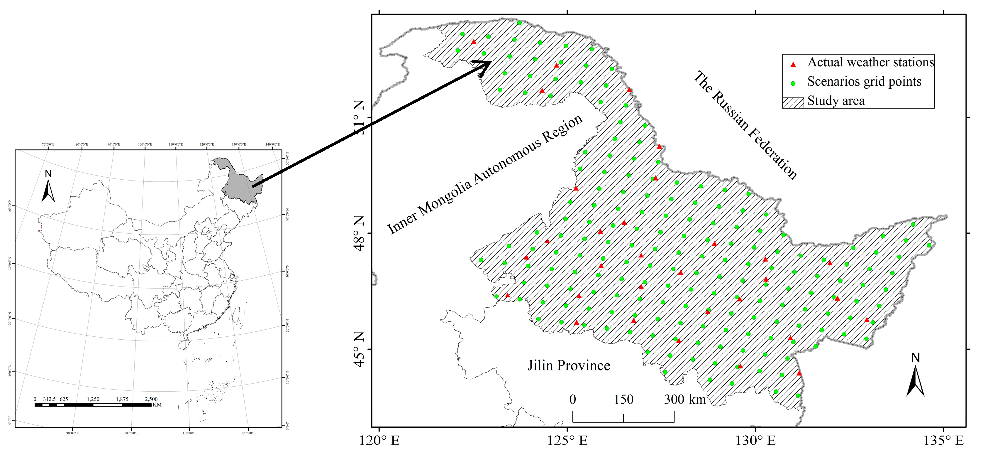
The impact intensity of climate on forest fires in different regions differs greatly. Heilongjiang Province is one of the regions that is most sensitive to climate change, and some studies have shown that there would exist potential increasing trend of fires in or around this region. The study by Tian et al. [
16] showed that the potential burned areas are expected to increase by 10% and 18% in spring for the 2080s under Scenarios A2 and B2, respectively. Fire season will be prolonged by 21 and 26 days under Scenarios A2 and B2 in the 2080s, respectively, in northeastern China. The peak fire season will appear in advance, and the potential burned areas will increase by 20% in the 2040s under Scenario B2. Additionally, the study by Liu et al. [
17] showed that the fire density in the frigid forests in northeastern China is predicted to increase by 30% (B1 scenario) to 230% (A2 scenario) during the period of 2081–2100. Human-caused fire occurrences will increase by 72.2% under the RCP 2.6 scenario and by 166.7% under RCP 8.5 [
18]. It is anticipated that the number of extremely high fire danger days will increase from 44 days in the 1980s to 53–75 days by the end of the 21st century under the scenarios of SRES A2a and B2a in the Great Xing’an Mountains [
19].
The FWI system is a system of daily meteorological-based indexes designed and used universally in Canada to estimate fire danger in a generalized fuel type [
20]. The FWI and its components have been found to effectively evaluate potential future fire activity when coupled with climatic scenarios [
21,
22,
23,
24,
25,
26]. Recognizing that China is among the nations with the most extensive forested areas and is disproportionately impacted by severe forest fires, there is an urgent need to investigate the response characteristics and the incidence trends of forest fires in representative regions of China, particularly in the context of climate change. Forest fires can be categorized based on the extent of damage to the trees and the area into the following categories: general forest fires, significant forest fires, major forest fires, and particularly severe forest fires. The number of forest fires is the sum total of all occurrences of forest fires.
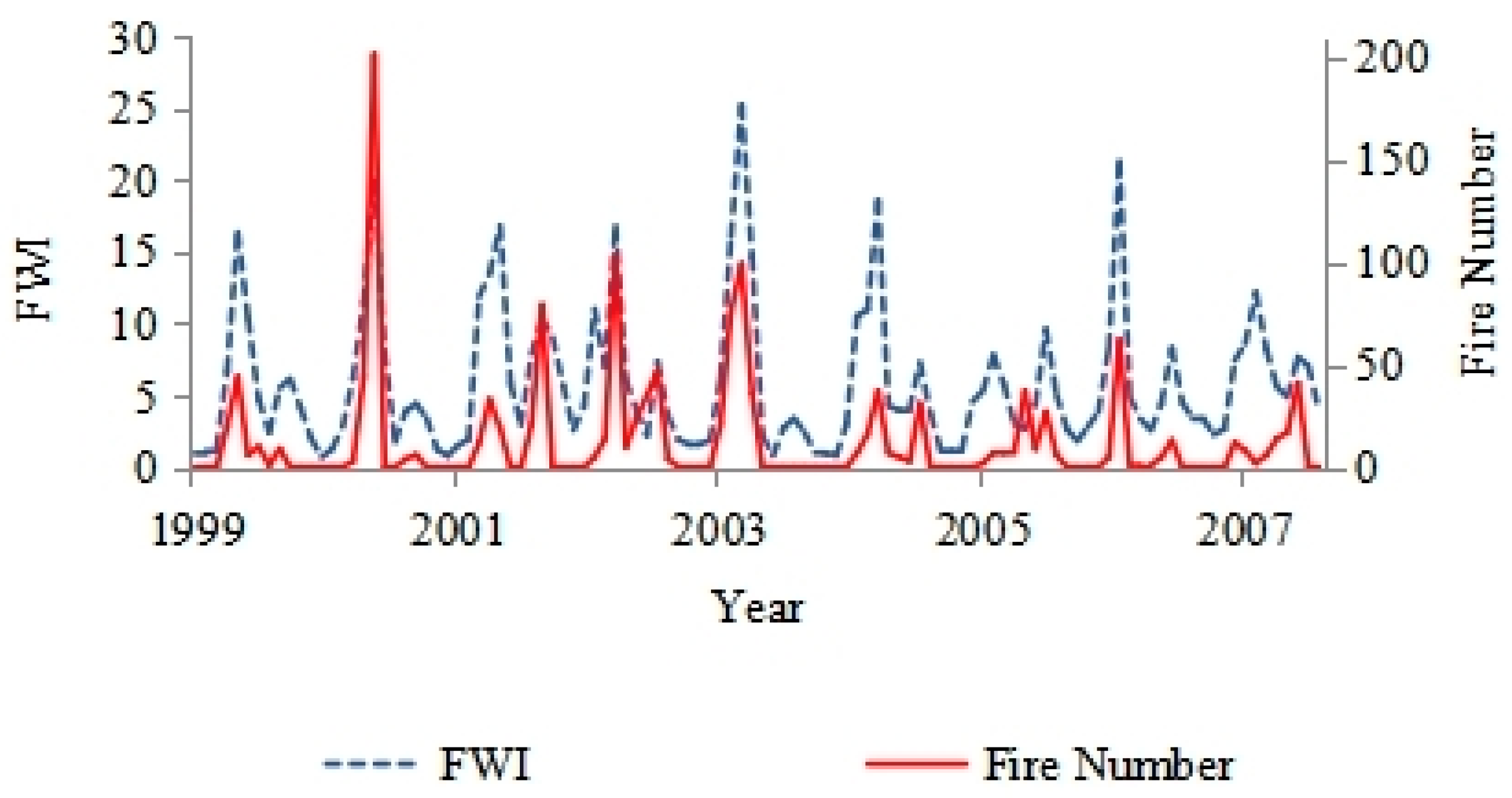
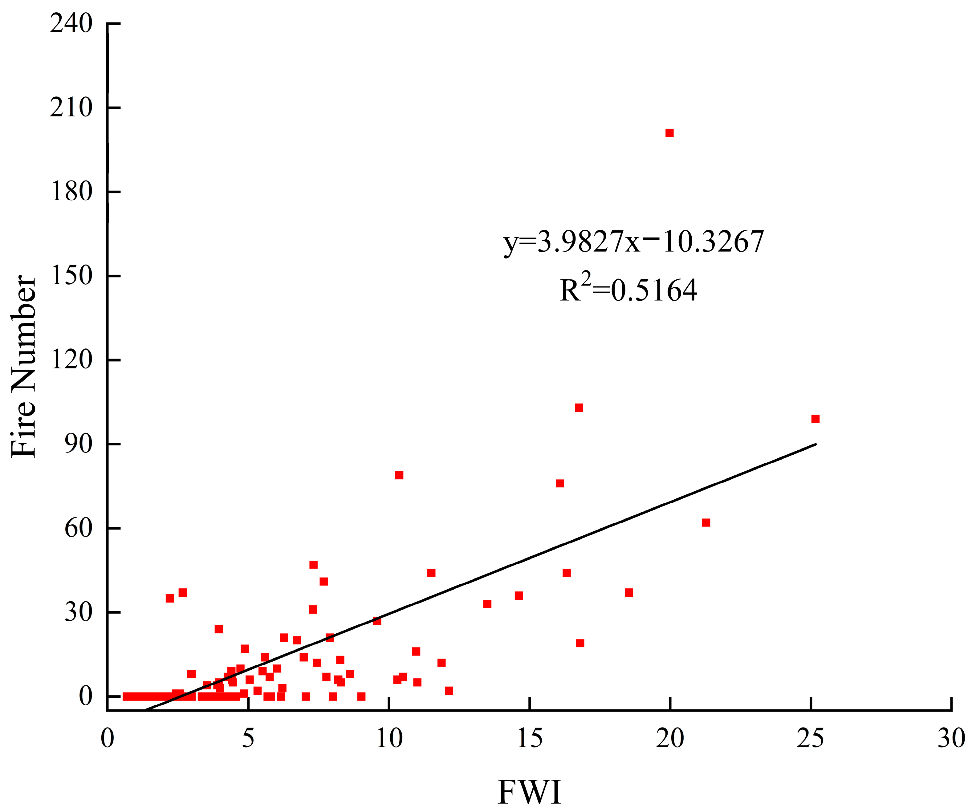
This paper analyzes the monthly variations in the number of fires and the FWI and constructs a linear equation to evaluate the trend and variability of fire numbers in relation to the FWI. The focus of this paper is on the trends in the number of fires, air temperature, and precipitation under two distinct climatic scenarios. Additionally, the paper addresses the monthly rate of change in various factors associated with fire occurrence, which is linked to the seasonal dynamics of fire activity. The spatial patterns of FWI changes under the A2 and B2 scenarios across different time periods are also presented.
3. Results
3.1. The Trend of Weather, FWI Components and Fire Number
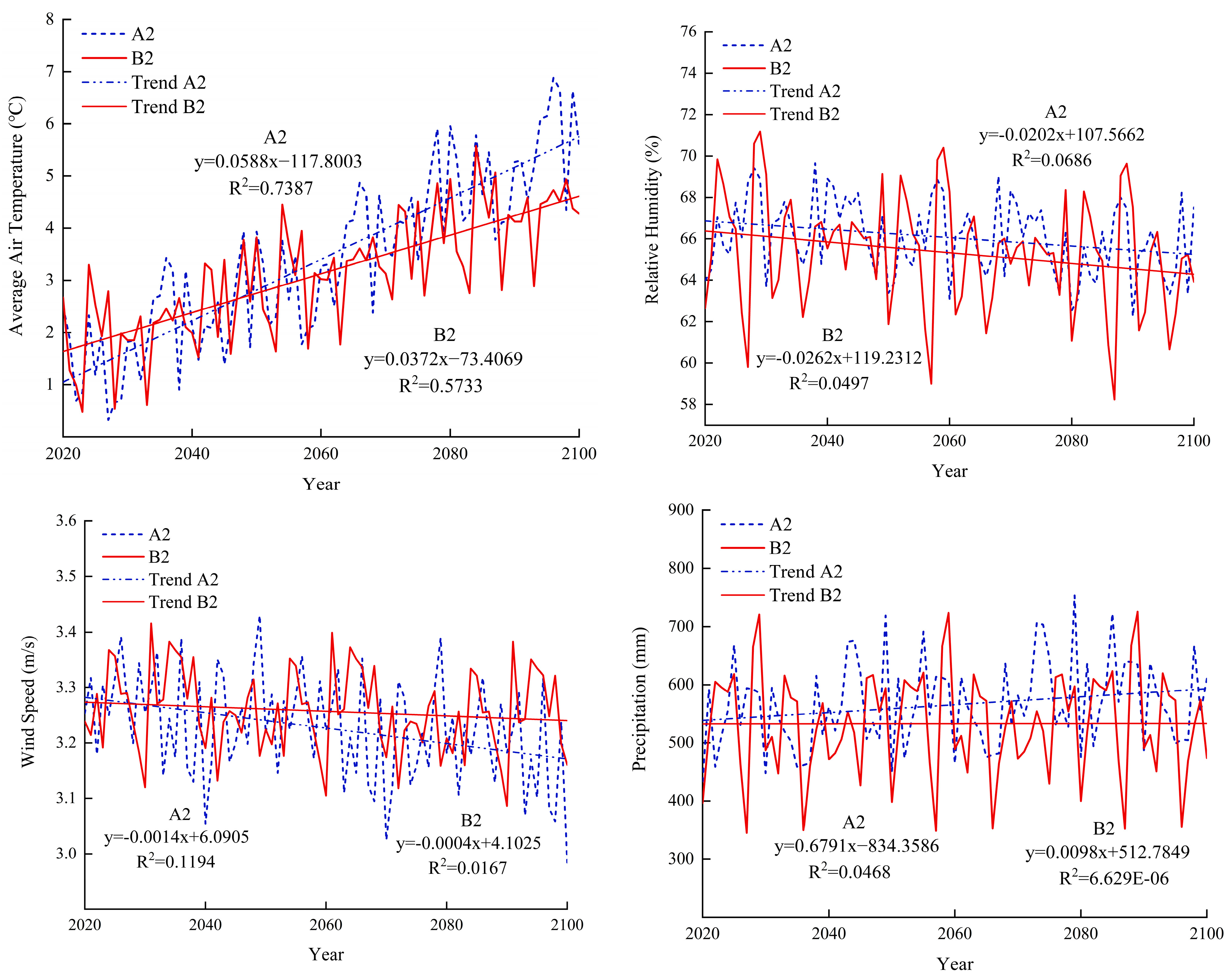
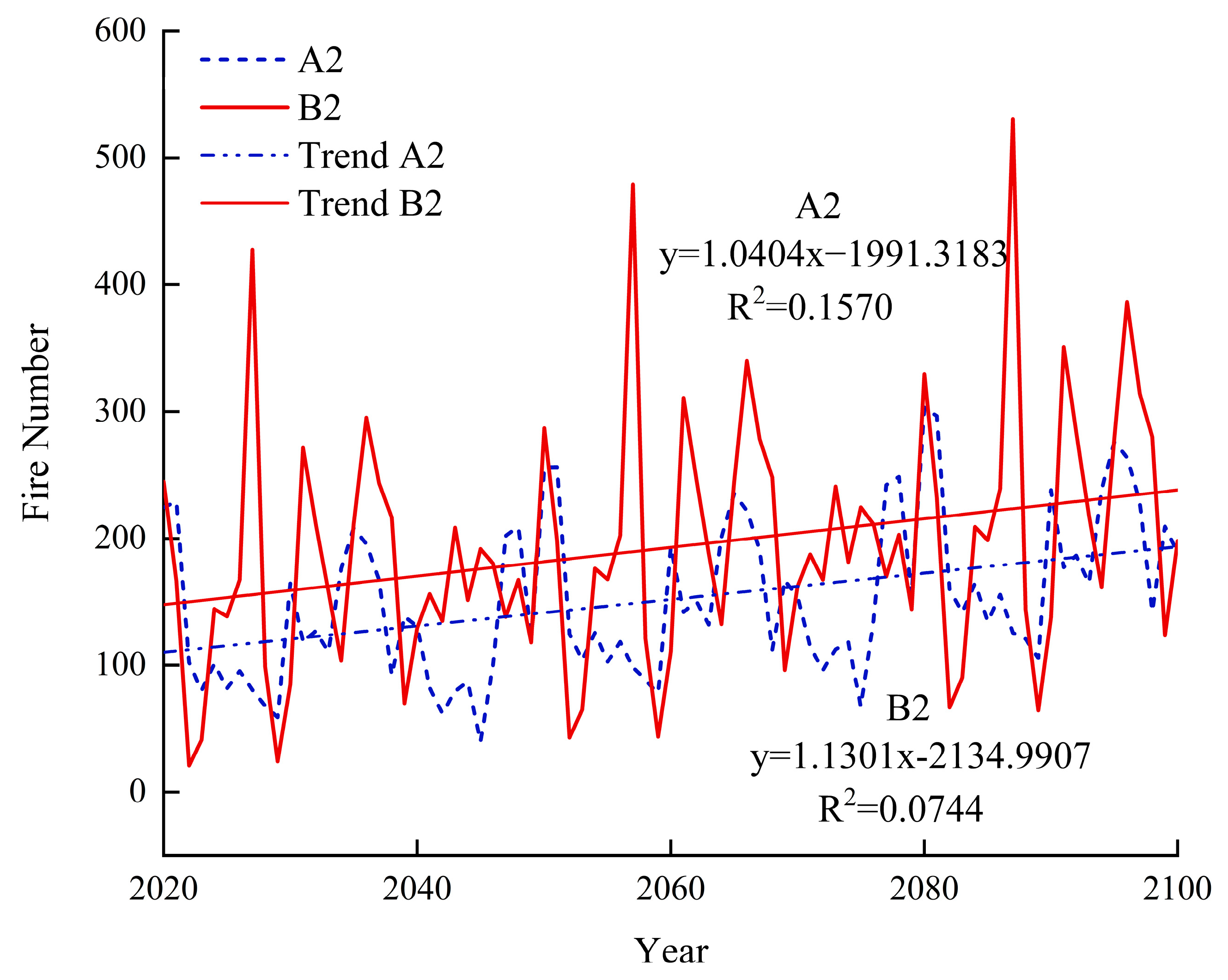
The fire number has an increasing upward trend for 2020–2100 under the A2 and B2 climatic scenarios. As can be seen from
Figure 4, the temperature has a relatively obvious rise, with scenario A2 showing a larger rise. Under the A2 climate change scenario, the average annual temperature is 1.31 °C in the 2020s and 5.71 °C in the 2090s, increasing by 4.39 °C. Under the B2 climate change scenario, the average annual temperature is 1.85 °C in the 2020s and 4.33 °C in the 2090s, increasing by 2.48 °C.
The annual mean of relative humidity and wind speed both show a downward trend. Under the A2 climate change scenario, the average annual relative humidity in the 2020s was 66.73%, and in the 2090s was 64.81%, decreasing by 1.92%. In the B2 climate change scenario, the average annual relative humidity is 66.37% in the 2020s and 64.04% in the 2090s, a decrease of 2.33%, which is even greater in the B2 scenario. Under the A2 climate change scenario, the average annual wind speed is 3.28 m/s in the 2020s and 3.17 m/s in the 2090s, decreasing by 3.34%. Under the B2 climate change scenario, the average annual wind speed in the 2020s has no significant change from that in the 2090s, but the general trend is downward.
Under the A2 climate change scenario, the average annual precipitation is 552.49 mm in the 2020s and 555.36 mm in the 2090s, increasing by 0.52%. Under the B2 scenario of climate change, the average annual precipitation in the 2020s is 551.48 mm, and in 2090s is 516.06 mm. Although the general trend is rising, the annual precipitation in the 2090s is 6.42% lower than that in the 2020s due to the change of inter-annual volatility.
As can be seen from
Figure 5, the factor values of each component of the FWI system in the 2020s–2090s have increased to varying degrees. Under the A2 climate change scenario, the annual FFMC average is 73.20 in the 2020s and 75.92 in the 2090s, increasing by 3.71%. Under the B2 climate change scenario, the annual FFMC average is 73.90 in the 2020s and 76.43 in the 2090s, increasing by 3.42%.
Under the A2 climate change scenario, the annual average of DMC in the 2020s is 14.25 and 19.87 in the 2090s, which increased by 39.44% compared to the 2020s. Under the B2 climate change scenario, the annual mean of DMC in the 2020s is 16.33, and in the 2090s is 22.89, increasing by 40.12%.
Under the A2 climate change scenario, the annual mean value of DC in the 2020s and the 2090s was 197.27 and 266.36, respectively, and that in the 2090s increased by 35.02% compared to the 2020s. Under the B2 climate change scenario, the annual mean value of DC in the 2020s is 220.42, and 295.62 in the 2090s, increasing by 34.12%.
Under the A2 climate change scenario, the annual average of ISI in the 2020s and the 2090s is 2.74 and 3.32, increasing by 21.08%. Under the B2 climate change scenario, the ISI annual mean is 2.92 in the 2020s and 3.48 in the 2090s, increasing by 19.31%.
Under the A2 climate change scenario, the annual mean value of BUI in the 2020s was 22.02, and in the 2090s was 31.20, increasing by 41.73%. Under the B2 climate change scenario, the annual mean value of BUI in the 2020s was 25.58, and in the 2090s was 35.98, which increased by 40.68%.
Under the A2 climate change scenario, the annual mean of the FWI was 4.94 in the 2020s and 7.04 in the 2090s, increasing by 42.47%. In the B2 climate change scenario, the annual mean of the FWI is 5.68 in the 2020s and 7.90 in the 2090s, increasing by 39.10%.
3.2. Monthly Analysis of Weather Data and FWI Components
Each month from 2020 to 2100 was derived from the database of weather and FWI components, and a linear regression equation was obtained for each weather factor or FWI components from serial data of each month. The slope of the linear equation can be obtained from the regression analysis, and the slope determines the increase or decrease in rate for each factor. The slope varies with month, representing the impact intensity of climate change on these factors over time. All the results showed that there was a faster change in the summer. The slope only indicates the rate change, whether an decrease or increase, and does not indicate the relative values of different factors. As can be seen from
Figure 6, in scenario A2, precipitation increases from January to December, especially in July, and the rate of precipitation increases the fastest. In scenario B2, the precipitation from July to September show a downward trend, and the decline rate is the fastest in August. In the A2 and B2 scenarios, the average temperature shows a rising trend, while in A2 scenario, the warming rate is faster, and August is the month with the fastest warming rate.
As can be seen from
Figure 6, FFMC increases the most in July and August under the two scenarios, and the probability of occurrence of summer fires will increase, but in some months of autumn and winter, there is a downward trend, though it is not obvious. DMC and DC showed an increasing trend in the A2 and B2 scenarios. Under the A2 and B2 climate change scenarios, FWI increased at a relatively high rate from May to September. Precipitation and air temperature are the most important factors influencing FWI and, consequently, fire occurrence. Air temperature in all the months showed increasing tendency, and the air temperature in August, which is the summer of the study area, has the most rapid increasing speed. At the same time, the precipitation in July to September would become lower. All these together may explain the reasons why FFMC would increase mostly in summer under the A2 and B2 scenarios, as surface fuel responds rapidly with the change of weather.
3.3. Fire Number under A2 and B2 Climate Scenarios
The number of fires showed an increasing trend under both scenarios (
Figure 7). Under the A2 climate change scenario, the annual average number of fires in the 2020s was 112, and the maximum number of fires occurred in the 2090s was 213, an increase of about 89.35% compared to the 2020s. Under the B2 climate change scenario, the annual average number of fires in the 2020s is 147, and the maximum number of fires is 254, which occurs in the 2090s, increasing by 71.95%.
Figure 8 shows the increase in percentage of fire frequencies every 10 years in the 2020s–2090s. Under the A2 and B2 scenarios, the overall trend is rising, the increase percentage range of the A2 scenario is 2.98–129.97%, and that of B2 is −2.86–103.30%.
3.4. Spatial Pattern of FWI Increasing
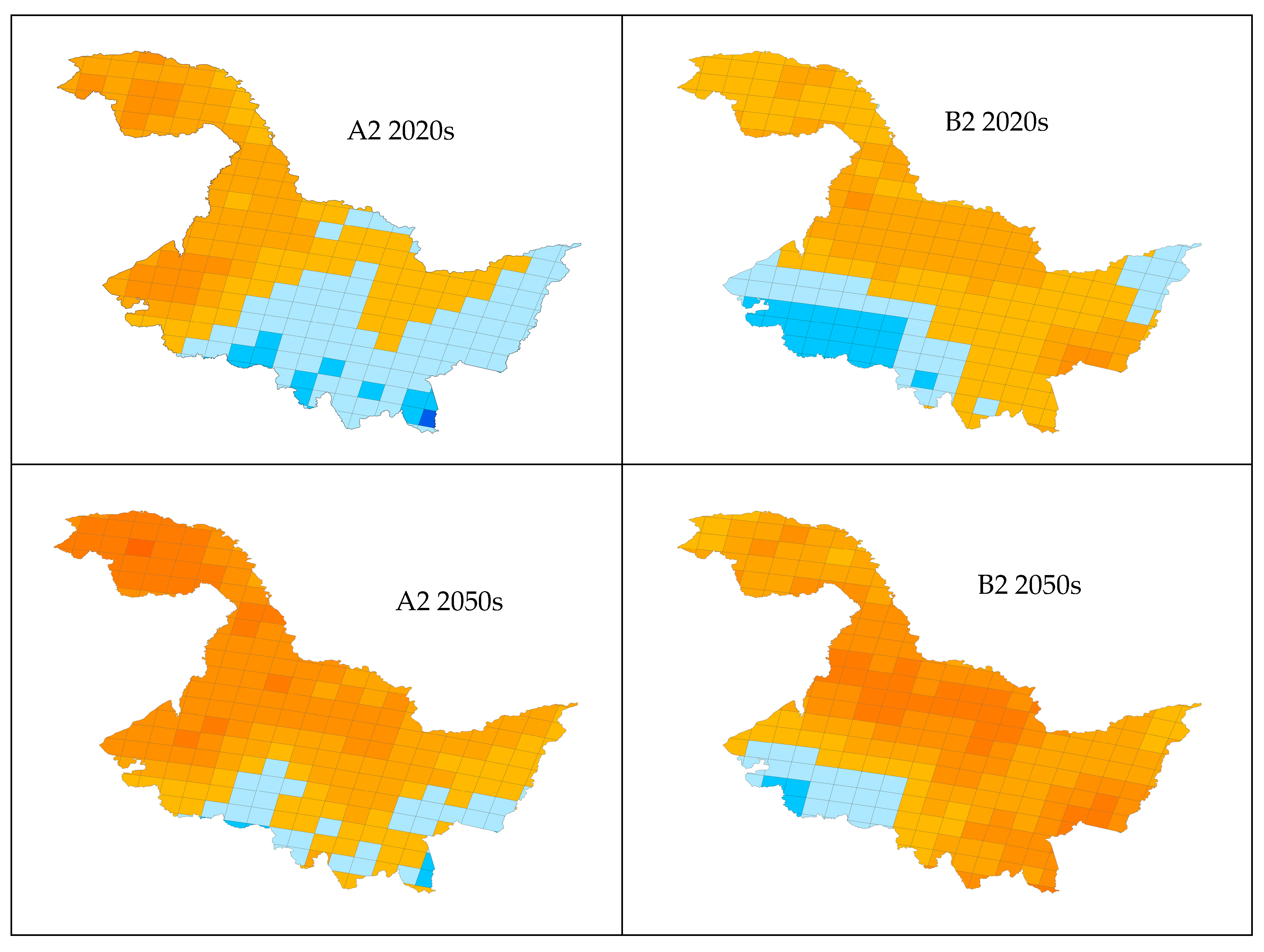
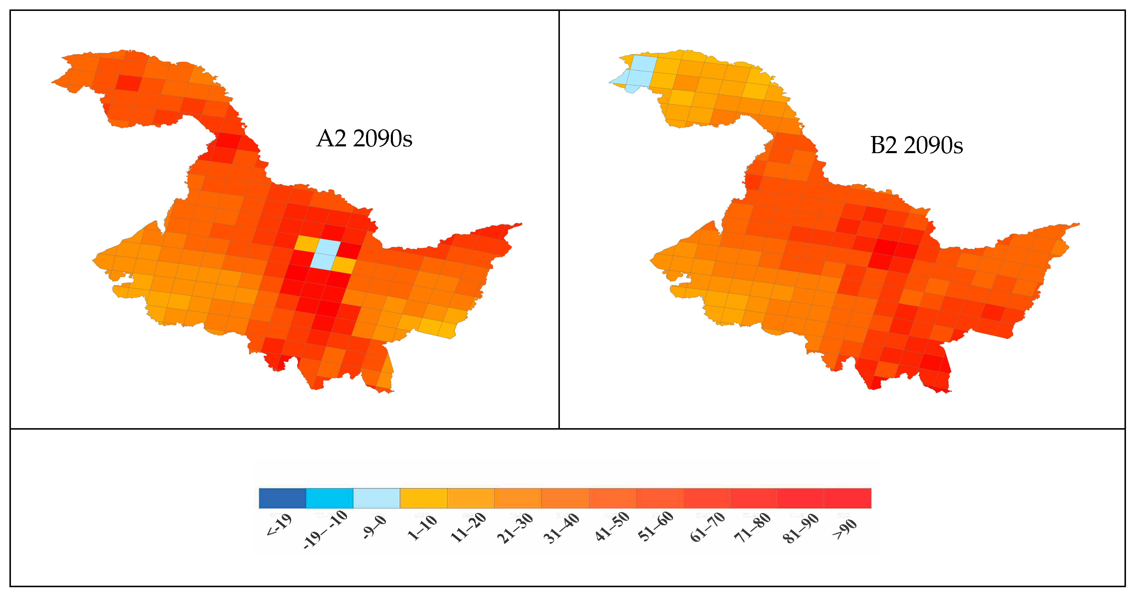
The key factor FWI was selected from all factors related to forest fire occurrence, and three time periods, 2020s, 2050s, and 2090s, were selected, respectively. The change rates of 2050s, 2090s and 2020s were calculated respectively under different scenarios, and the spatial pattern changes of these three key factors were analyzed (
Figure 9). In the A2 scenario, the FWI increases in the 2050s and 2090s compared to the 2020s. In the 2050s, the FWI mainly increases in the eastern and central regions with a maximum increase of 41% to 50%, while the western and southeastern regions have a small increase. In the 2090s, the FWI value increased by more than 90%, and the region with the largest increase was the central and southern regions.
In the B2 scenario, FWI values in the northern and southern regions of the 2050s and 2090s both increase significantly, but with the intensification of climate influence, the regional difference will no longer be obvious. In the 2050s, the maximum increase is 31–40%, and there is no significant change in the western region. With the increase of extreme climate events, the local FWI decreases within the region, and the maximum increase is higher than 90% in the 2090s. In the 2090s, the FWI slightly decreases in the Greater Khingan Mountains region.
3.5. Model Verification of Fire Number
The frequency of fire occurrences obtained by linear model simulation from 1999 to 2007 and the frequency of fire occurrences under scenarios A2 and B2 are shown in
Table 1. It can be seen that the predicted fire numbers are lower than the observed number of fires. In 2019, the prediction of the B2 scenario model was accurate. In 2021 and 2022, the actual number of fires was 0, which may be related to the strengthening of forest lightning fire management in the Greater Khingan Mountains region of Heilongjiang Province.
4. Discussion
In this paper, average temperature for each decade of 2020–2090 in Greater Khingan Mountains region of Heilongjiang increased significantly. By analyzing the influence of climate factors on forest fire interference, it was found that there is a high correlation between climate factors and forest fires [
34,
35]. In the context of climate warming, forest fire disturbance in China shows an increasing trend, and it is revealed that extreme climatic events such as El Niño-Southern Oscillation (ENSO) and drought can induce forest tree death, increase forest fire fuel loads, and reduce fuel water content, so as to control forest fire disturbance dynamics [
36]. Although forest fire interference is comprehensively affected by climate, topography, vegetation, and fire source (natural or man-made), climate is the main factor affecting fire occurrence density, burned rate, and median fire size in China, and other factors have relatively little influence [
37,
38]. Temperature, relative humidity, precipitation, and wind speed independently and/or synchronously contribute to an increase in both the frequency and severity of fires globally [
39,
40]. In this study, we have observed a pronounced increase in temperature from 2020 to 2090, which could significantly influence forest fire dynamics. Concurrently, under both the A2 and B2 scenarios, alterations in precipitation and relative humidity are noted to be relatively stable. This stability in moisture-related variables might mitigate the fire risk to some extent; however, the significant temperature rise could still be a primary driver of increased forest fire potential. Higher temperatures are likely to enhance evapotranspiration rates, reducing soil and vegetation moisture, thereby creating conditions more conducive to the ignition and spread of wildfires. The implications of these findings for forest fire management are profound. While the stability in precipitation and relative humidity may offer some respite, the overriding concern is the potential for more frequent and intense fires due to the pronounced temperature rise. Forest ecosystems, which are already under stress from various anthropogenic pressures, may face further challenges in adapting to these changing climatic conditions. It is crucial for forest managers and policymakers to consider these projections in the development of adaptive strategies to mitigate the impacts of climate change on forest fire risks. Moreover, the observed stability in precipitation and relative humidity across different decades suggests that while the climate system may exhibit some resilience, the interplay between these variables and the pronounced temperature rise requires further investigation. Understanding the complex interactions between these factors is essential for predicting how forest ecosystems will respond to future climate scenarios and for formulating effective fire management policies. This stability may be attributed to the more pronounced anthropogenic influence on temperature relative to precipitation patterns [
41]. However, the study of the Quebec boreal region is expected to experience increases in both precipitation and temperature under future warming scenarios [
42]. Nonetheless, the fire frequency for boreal stands is expected to be greater because higher temperatures will concentrate the precipitation in some short periods that will result in drier conditions during long periods of the year [
43]. The FFMC scale ranges 0–99 with higher values indicating drier fine fuels and greater fire danger [
44]. The data showed a general increasing trend of the FFMC to the highest 78.28 (A2 scenario) in 2099 and 79.53 (B2 scenario) in 2087 (
Figure 5). It was reflected by the progressive drying of fine fuels, resulting in a large number of forest fires during that time in Heilongjiang province. A gradual increase in FFMC value appears to indicate large fire occurrences, with fine fuels on the landscape leaving a potential to burn.
In this study, the increase in forest fire occurrence density in Heilongjiang Province (A2 scenario is 2.98–129.97%, and that of B2 is −2.86–103.30%) is lower than the results of Liu et al. [
17] on the increase of forest fire occurrence density in the northern forests of China (increased by 30–230% during 2081–2100). The reason is that the rainfall in the northern region is relatively low, so the water content of fuels is low. Moreover, the increase in temperature leads to the enhancement of evapotranspiration of forests, which further aggravates the water deficit [
45]. In addition, the warm climate conditions prolong the growing season of plants, increase the accumulation of fuels, and further aggravate the disturbance of forest fires. De Groot et al. [
46] used several models and concentration scenarios to simulate the effects of climate change on daily severity ratings in two large northern study areas in Canada and Russia. All models and climate change scenarios indicate that future fire weather conditions in both regions will be more severe during the peak fire season in the late 21st century than they were in the late 20th century, with increases of up to four to five times, with the largest increases in western Canada. In this paper, under scenarios A2 and B2, precipitation and temperature increased or decreased most rapidly in summer, which led to the maximum change rate of FFMC and DC in summer. While considerable variability exists in changes in summertime rainfall amounts (both increases and decreases), it has been demonstrated that increases in fuel moisture due to projected increases in rainfall are more than offset by increased evapotranspiration from fuels on and in the forest floor [
47]. Stocks et al. [
48] studied four atmospheric circulation models to predict the forest fire risk level of Canada and Russia under climate change scenarios. Through the simulation of Canadian GCMs, the analysis of monthly data showed that the fire risk period was advanced, and the high and extreme fire risk conditions of Canada and Russia increased significantly, especially in June and July. This will also have important implications for forest fire management.
A study of future forest fire seasons in South Korea projected that the frequency of forest fires during the summer season will increase in the future (2071–2100). In particular, there will be a 15% increase in July compared to the current climate. A decrease in relative humidity and an increase in wind speed will also affect the frequency of forest fires [
49]. This is consistent with our research. Furthermore, the reduction in seasonal precipitation and the decrease in moisture content of combustible materials play a decisive role in the frequent occurrence of lightning fires. Particularly, the months with reduced precipitation align with those characterized by a high frequency of lightning strikes. The imbalance between lightning ignition sources and seasonal moisture may lead to frequent fire outbreaks even in humid climate conditions. Climate change causes changes in the frequency and distribution of lightning, which leads to changes in the types and loads of combustible materials in forests. The probability of lightning-induced fires increases, the affected area expands, and the fire prevention period is extended, thereby increasing the danger of heavy and especially large forest fires. Extreme weather conditions are often prone to triggering large-scale and widespread lightning fires. The warming climate and extreme weather conditions lead to an increase in dry lightning storms, and research shows that the probability of lightning-induced fires in the Xing’an Mountains has increased in all climate scenarios. In the A2 scenario, the probability of lightning-induced fires in the 2090s is 292.98% higher than in the 2010s, and in the B2 scenario, it is 84.18% higher [
50]. Climate change leads to an increase in abnormal weather conditions and the occurrence of dense lightning processes, resulting in frequent occurrences of mass lightning fires.
The spatial prediction of forest fire occurrence has important implications for forest fire management. The results of this study show that under the A2 climate scenario, the FWI increase rate is higher in the Greater Khingan Mountains and the southern part of Heilongjiang Province, while under the B2 scenario, the FWI decreases slightly in the Greater Khingan Mountains, and the increase percentage is greater than 90% in the central and southern regions. Under the A2 Scenario, the increase rate of the FWI is higher than that in the B2 Scenario. This may be due to higher population growth and carbon emissions in A2 compared to B2, leading to increased temperatures that make forest fires more likely. Additionally, population growth leads to a significant increase in human-caused fires, resulting in more fires and a greater increase in the rate of FWI (%). In the southwestern region, the lower increase rate of the FWI (%) percentage is related to the sparse vegetation distribution there. In contrast, the northern Greater Khingan Mountains region has high vegetation coverage, making it the region with the largest increase in the FWI percentage. In the 2050s, the blue areas indicating a negative increase rate of the FWI (%) include urban areas such as Harbin and Daqing, which have less forest distribution. In the 2090s, the negative growth rate under the B2 Scenario may be related to forest lightning fire control technology. The Greater Khingan Mountains region, being remote and at a higher latitude, is prone to forest fires caused by lightning strikes, which are the main type of forest fire there. Implementing effective measures to control lightning-caused fires could potentially lead to a decrease in the rate of FWI (%).
The spatial forecasting of forest fire occurrences is of paramount importance for guiding effective forest fire management strategies. This study’s findings indicate that, under the A2 climate scenario, the rate of increase in the FWI is notably higher in the Greater Khingan Mountains and the southern regions of Heilongjiang Province. In contrast, under the B2 scenario, the FWI experiences a slight decline in the Greater Khingan Mountains, yet a significant surge of over 90% in the central and southern parts. Within the purview of Canadian forest fire weather studies, trends that are pronounced yet often statistically non-significant have been identified throughout the twentieth century, while also accentuating the spatial heterogeneity of fire weather trends across the country [
51,
52]. Some recent studies have demonstrated a significant upswing in the extreme values of FWI, which are most perilous for the propagation of wildfires, a consensus that has been reached among fire management personnel (for instance, when FWI > 20), particularly in western Canadian forests [
53]. Compared with the increase in FWI, the change of FWI ratio can better reflect the relationship between forest fire risk and potential burned area. The relationship between the fire risk weather index and fire area is 1:1; that is, a 50% increase in FWI will cause a similar increase in fire area [
54]. The spatial structure of fire weather is estimated to be responsible for an average of 25% of the spatial patterns of fires, suggesting that climate change may directly affect the spatial patterns of fire hazards in the near future [
55]. The use of the composite fire danger index FWI, as well as its sub-indices, the build-up index (BUI) and the initial spread index (ISI), has a better correlation with forest or non-forest BA than with a single climate variables, for most regions across the globe [
56]. Although the change in burned areas caused by climate change is not considered in this analysis, the increase of the fire risk index and the significant extension of the fire risk period may lead to the increase of fire activities in the future. If the fire prevention capability of the current fire management agency is not greatly improved, it can be predicted that the wildfire burned area of Heilongjiang Province will significantly increase. In a warming climate, the success rate of the initial attack will decrease, and the proportion of the fire area increased is greater than the variability of the fire risk index [
57].
The observed number of fires in Heilongjiang Province from 2010 to 2022 showed an increasing trend, as well as the model prediction; however, the actual number of fires was much higher than the model prediction in all years except 2021 and 2022. Therefore, the fire risk predicted by the model can only accurately represent the average state of a time period; however, it cannot simulate the change of the number of fires in each year. Furthermore, due to the strict and comprehensive implementation of forest fire management strategies, as well as the forest protection and green development concepts, the number of fires has decreased in recent years. According to studies and model simulations, climate warming in China and around the world will continue, leading to longer forest fire days, increased fire risk, and greater challenges for forest fire prevention. Therefore, it is necessary to strengthen research on the impact of climate change on forest fires, improve forest fire monitoring, prediction, and early warning systems, and raise public awareness of forest fire prevention.
5. Conclusions
This study concentrates on Heilongjiang Province, a representative region in China, employing monthly provincial forest fire records, observed meteorological data, and climate change scenario projections to dissect the spatiotemporal dynamics of forest fires and their response characteristics within the context of climate change in the study area. By leveraging the components of the FWI system from the CFFDRS as foundational evaluative metrics, the study assesses the applicability and sensitivity of the FWI in typical regions of China. This foundational analysis is further utilized to scrutinize the trends in meteorological factors, FWI system components, fire occurrence patterns, and spatial distributions in the research area from 2020 to 2100 under the SRES A2 and B2 scenarios. The pivotal findings are encapsulated as follows:
(1) With Heilongjiang Province designated as the research area, the local spatiotemporal particularities of forest fires were analyzed. The components of the FWI system were derived using observed meteorological data alongside the SRES A2 and B2 scenario projections. Key determinants were identified to formulate a probability model for forest fire occurrences in Heilongjiang Province, which facilitated the development of a quantitative approach to delineate the fire risk period.
(2) Regional variations within Heilongjiang Province are pronounced. Over the course of the 2020s to the 2090s, the temperature in Heilongjiang Province escalated by 4.86℃ under the A2 climate change scenario and by 2.88 °C under the B2 scenario, underscoring a marked warming trend in the high-latitude regions of China. In the 2090s, the FWI values soared by over 90%, with the most considerable increase noted in the central and southern sectors of the region.
(3) An upward trajectory characterizes the forest fires in Heilongjiang Province from 2020 to 2100. Between the 2020s and the 2090s, under both the SRES A2 and B2 scenarios, there was a substantial rise in both FWI and the incidence of fires in Heilongjiang Province, with the latter escalating by more than 70%. The months of May and June recorded notable surges in FWI, while a sharp increase was also detected in October, indicative of the intensifying fire risk during these periods.
