Article

A Dijkstra-Based Approach to Fuelbreak Planning

Department of Geophysics, Porter School of the Environment and Earth Sciences, Tel Aviv University, Tel Aviv 69978, Israel
*
Author to whom correspondence should be addressed.
Fire 2023, 6(8), 295; https://doi.org/10.3390/fire6080295
Submission received: 22 June 2023 / Revised: 22 July 2023 / Accepted: 30 July 2023 / Published: 31 July 2023
(This article belongs to the Special Issue Nature-Based Solutions to Extreme Wildfires)

Abstract

:
One of the most effective methods of preventing large-scale wildfires is creating fuelbreaks, buffer zones whose purpose is to stop or delay the spread of the fire, providing firefighters an opportunity to control the fire. Fuelbreaks are already applied in several countries and have proven their effectiveness. However, creating fuelbreaks involves deforestation, so the length of the fuelbreaks should be minimized as much as possible. In this paper, we propose the implementation of a greedy Dijkstra-based fuelbreak planning algorithm which identifies locations in which fuelbreaks could significantly reduce the risk of large wildfires, at a relatively low deforestation cost. We demonstrate the stages and output of the algorithm both on artificial forests and on actual forests in Israel. We discuss the factors which determine the cost effectiveness of fuelbreaks from a tree-economy perspective and demonstrate how fuelbreaks’ effectiveness increases as large wildfires become more frequent.

1. Introduction

Fuelbreaks are gaps in vegetation whose purpose is to delay or stop the spread of wildfires. While some fuelbreaks are natural (e.g., rivers), they can also be man-made. Despite their acknowledged effectiveness, few countries implement fuelbreaks systematically. The reasons for the scarce use of fuelbreaks are primarily the economic and ecological costs involved in creating them. Therefore, we find it especially important to provide decision makers with practical tools for planning and implementing efficient fuelbreaks. In this paper, we provide an algorithm for planning effective fuelbreaks while minimizing the necessary deforestation.
The effectiveness of fuelbreaks has been acknowledged for decades (e.g., [1]). Forest fires are known to follow the Pareto principle: almost 95% of the forests burned are consumed by only 5% of the forest fires [2,3]. Reducing the few most extreme fires could therefore substantially reduce global burned areas. Fuelbreaks are especially effective in preventing these major fires. One example of a successful fuelbreak implementation could be found in France, one of the most advanced countries in terms of fuelbreak implementation [4]. A French report has found that 90% of the houses that had acted according to French fuelbreak regulations were unaffected by the major 2003 fires in Europe [5].
Fuelbreaks have several disadvantages that prevent their widespread use: they are costly, they require maintenance and perhaps most importantly—they involve deforestation and affect the natural landscape [6]. For these reasons, the use of fuelbreaks has remained relatively limited despite their acknowledged effectiveness. Scholars and forest managers have developed several alternative fire risk reduction strategies that do not involve deforestation, such as green fire barriers [7,8]. Although these alternative strategies are not in the focus of the current study, we find it important to mention them as additional significant tools in wildfire mitigation strategies.
To minimize these disadvantages, researchers have studied the minimal fuelbreak width required for preventing the spread of fires. The main variables considered have been the effect of wind [9], topography and slope [10], as well as the fuel characteristics [11]. To assess wildfire behavior, researchers have applied various fire spread simulations such as the Wildland-urban interface Fire Dynamics Simulator (WFDS), a computational physics-based fire behavior model [12,13,14]. Generally speaking, if the fuel treatment includes a complete deforestation of the fuelbreak, its recommended width is approximately 2.5 times the height of the surrounding trees. As these widths could be rather large and reach up to dozens or hundreds of meters, forest managers also apply additional methods of fuel treatment. One such method involves creating partial deforestation in strips of vegetation that have been altered to delay the spread of fires. While the deforestation in these strips is partial, the width of these strips must be larger to be as effective as strips of complete deforestation. Narrow fuelbreaks do have some effect on delaying wildfires, but cannot completely prevent their spread; for example, burning pinecones could be dispersed to a distance of up to hundreds of meters by winds, passing every reasonable fuelbreak [15]. An additional alternative of fuelbreaks is prescribed burning—the deliberate application of fire to forest fuels under specified conditions. Both computer simulations and empirical studies have shown that prescribed burning substantially reduces the risk of future extreme wildfires.
While the width of the fuel treatments is undoubtedly an important factor, the economic and ecological costs of fuelbreaks are significantly determined by the length of their paths. Ideally, the paths should be as short as possible, passing through regions of low tree density. Recent studies have applied various optimization algorithms of fuel treatment locations, for instance, using a cellular model to identify the most fire-propagating forest cells [16,17]. Ref. [18] used a mixed-integer programming approach to break the fire probability accumulation pathways to lower landscape fire risks in predefined weather conditions and fire ignition locations. Their model searched for efficient fuel treatment locations across a landscape with the objective of minimizing the total expected forest loss in the case of a wildfire in this landscape. Ref. [19] advanced the research in the field by applying a model that could contribute to fire management under various weather conditions and ignition points. They noted that previous studies had assumed a given weather condition, and by that, optimized the fuelbreak locations with respect to a single specific scenario. When different weather conditions occur, these fuel treatments could be ineffective. Ref. [20] performed spatial optimization for prescribed burning using a multiperiod mixed-integer programming model. They randomly divided the forest to polygons of reasonable size for fuel treatment and strategically chose polygons for prescribed burning for each period.
An additional common approach is to estimate the spread rate of fire paths and to minimize the fire spread rate using fuel treatment (e.g., [21,22,23]). For example, Ref. [23] applied an integer programming model which aimed at slowing the spread rate of possible wildfires and creating opportunities for suppression efforts.
Additional works combined ecological and practical considerations in the optimization procedure. Ref. [24] improved previous models by addressing operational constraints which limit the number of possible fuel treatments. They formulated a mixed-integer programming model which minimized the number of disjoint-prescribed burn regions and aggregated fuel treatment locations, facilitating the application of prescribed burning in these regions. Ref. [25] applied a mixed-integer programming model which focused on the maximum tolerable fire intervals when considering prescribed burning. Their model attempted to minimize the connectivity between a landscape which was represented as a polygon-based network. The model builds on [26], but also considers multiple vegetation types. Ref. [26] focused on the scheduling of fuel treatments and applied a mixed-integer programming model. They minimized the number of connected pairs of ‘old fuel cells’, cells which have not been treated for a defined period and are more prone to burning. Advanced extensions of their model included heterogenous landscapes, ecological considerations such as maximum tolerable fire interval which limits the frequency of prescribed burning. Ref. [27] applied an integrated integer programming model which maximized both over fire suppression preparedness and over fuel management planning. Fire suppression efforts can be divided into initial attack—suppression at the initial stages of the fire—and extended attack—suppression of large wildfires. In their study, Ref. [27] addressed the initial attack considerations. They considered a heterogenous landscape which is comprised of cells representing potential fire locations and candidates for fuel treatment. Their model provided recommendations for the allocation of both suppression resources and fuel treatment. Ref. [28] applied an iterative approach to integrate fire and forest management planning, seeking to exploit their interaction. They demonstrated how efficient spatiotemporal planning of timber harvesting could contribute to fire hazard management. They built on the Fire Protection Value (FPV) method described in [29] to identify crucial harvest stands—locations whose harvest could potentially reduce landscape flammability.
The vast majority of studies in this field apply fire simulations to identify the most fire-prone regions and recommend fuel treatment (most commonly prescribed burning) in these regions. To the best of our knowledge, no previous studies have provided a method of planning contiguous fuelbreaks which can potentially prevent the fire from crossing to adjacent regions. Although fuelbreaks are costly, in some scenarios they could be more effective than alternative methods such as prescribed burning, so we find it important to provide forest managers with tools of planning effective fuelbreaks when fuelbreaks are required. In this work, we wish to present an algorithm that could identify the most cost-effective fuelbreak paths while considering existing gaps in vegetation.
The paper is organized as follows: We begin by describing the study site, proposed algorithm and research design. We then examine the algorithm on two simple artificial forests, followed by demonstrations on a few actual forests in Israel. We also discuss the necessary length of fuelbreaks from a tree-economy perspective. We conclude with a discussion on the implications and significance of the results and suggestions for future research.

2. Materials and Methods

2.1. Study Area

Our study site includes several forests in Israel. Data for real forests in Israel were obtained from the Global Forest Watch tree coverage maps [30]. We focus mainly on the Carmel Forest located on the outskirts of the city Haifa (Figure 1). The vegetation in this region is characterized by a complex of Pinus halepensis–Pistacia palaestina–Cistus sp. associations on south facing slopes and Quarcus calliprinos–Pistacia palaestina associations on north facing slopes [31]. The regional vegetation is demonstrated in two pictures in Figure 2. A major and deadly fire initiated in the forest in December 2010 and claimed the lives of 44 men and women, making it the deadliest fire in Israel’s history. The fire burned 1.5 million trees spanning over an estimated 10,000 to 37,000 burned acres. We tested the algorithm using data for the pre-2010 fire in the Carmel Forest. We also applied the algorithm on three additional forests around the Jerusalem Mountains, all of which suffered from wildfires in recent years. All four locations are presented in Figure 1.

2.2. Fuelbreak Planning Algorithm

The simulation’s input includes the relevant maps of tree coverage and the maximum permitted forestry areas in each forest section, i.e., the maximum area of forest that we allow to be burned in a single fire. The simulation involves assuming a given desired fuelbreak width, based on the considerations described in the introduction section. The forest map is first converted to a matrix of binary values, having the value 1 in forested cells and 0 in the rest (using the highest available resolution). The matrix’s pixels are then aggregated into larger building block pixels of the size of the desired fuelbreak width.
The simulation begins with the entire forest area and tests whether the forest exceeds the maximum permitted forestry area. If it does, then the simulation searches for the optimal fuelbreak path by implementing the following steps:
  • The simulation finds all possible pairs of two nonadjacent pixels in the forest boundary.
  • For each pair, the simulation runs the Dijkstra [33] algorithm whose output is the ‘shortest path’ between the two pixels—in the meaning of minimal forestry area that the line passes through (i.e., the minimal sum of forestry cells in each path).
  • The algorithm then chooses the shortest path from all the valid paths; a path is defined valid if it divides the forest into two sections where at least one of the sections contains a lower forestry area than the maximal value permitted in a section. Paths that create extremely small forest sections (sections that contain a significantly lower forestry area than the maximal value) are disregarded.
  • Out of all the remaining possible paths between two boundary pixels, the simulation chooses the least costly path.
At this stage, there is at most one forest section that could potentially exceed the maximum permitted forestry area. If one of the remaining forest sections indeed exceeds the permitted value, the simulation reiterates steps 1–4 for this area. The simulation ends when no section of the forest exceeds the permitted forested area value. Its output is the chosen fuelbreak paths and their total cost.

2.3. Research Design and Data

The process begins with an input image as shown in Figure 3, whose width is 7 km. The green areas in the map mark regions in which the forestry area exceeds a certain value, in this example, 10%. The forest map is first converted to a matrix of binary values as in Figure 4a, having the value 1 in forested cells and 0 in the rest, using MATLAB functions. The matrix’s pixels are then aggregated so that each matrix cell’s square side is of the size of the user defined fuelbreak width, summing the number of forestry cells inside it (Figure 4b). For the current example, we chose a fuelbreak width of 200 m. We emphasize that this width was only chosen for the purpose of demonstrating the algorithm and different widths could be chosen based on topography, meteorological characteristics or other considerations.

3. Results

3.1. Examples of the Algorithm Run on Artificial Forests

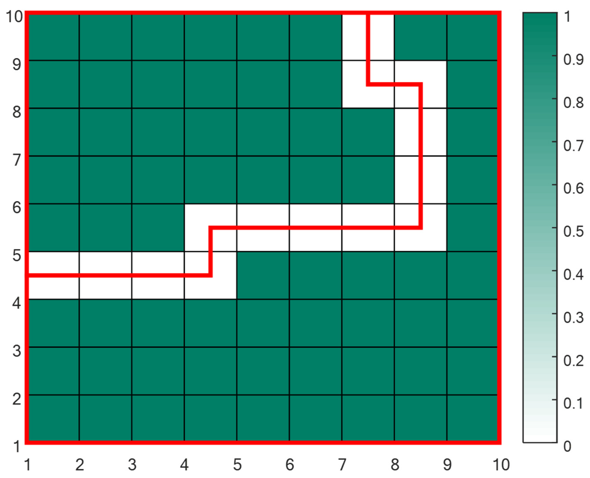
To test the algorithm and demonstrate its performance, we begin by applying it to two artificial forests. The first forest allows us to conduct a ‘sanity check’: we run the algorithm on a 67-forestry cells forest (green cells), having to be split into two areas of at most 60 forestry cells each. In Figure 5, white cells represent non-forestry areas and green cells represent forestry areas. The forest contains a natural path with no trees, where a simple fuelbreak solution could be found. As can be seen in Figure 5, the algorithm finds this simple optimal solution.
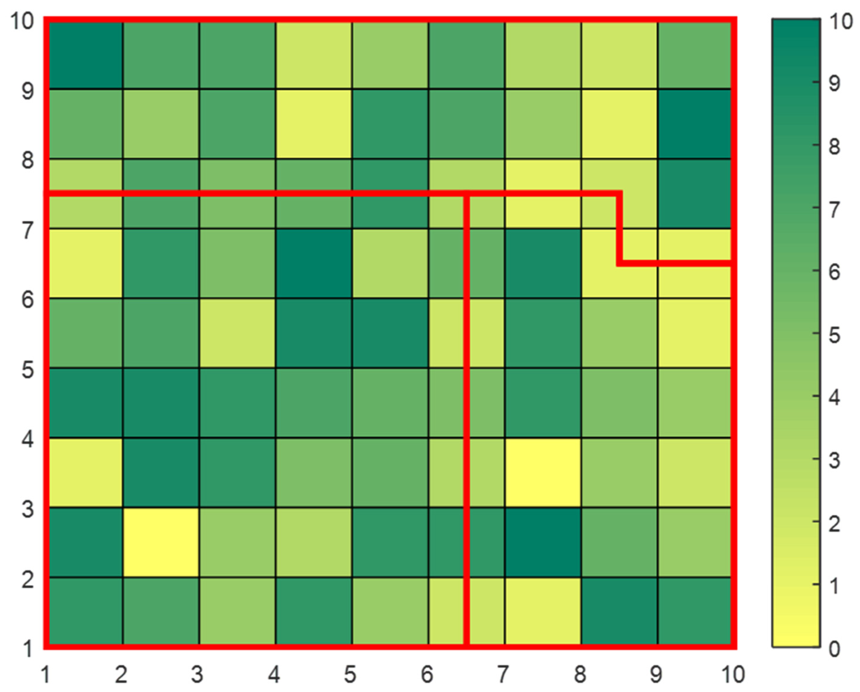
Figure 6 presents an additional example. This example is more challenging than the previous one since no trivial solution exists. Still, the algorithm finds the least costly path which divides the forest according to the input described in the figure’s caption. In contrast to the first example, the current forest requires two iterations of the algorithm (and two fuelbreak paths) so that it could meet the requirements that were defined for this example.

3.2. Actual Forest Run—The Carmel Forest

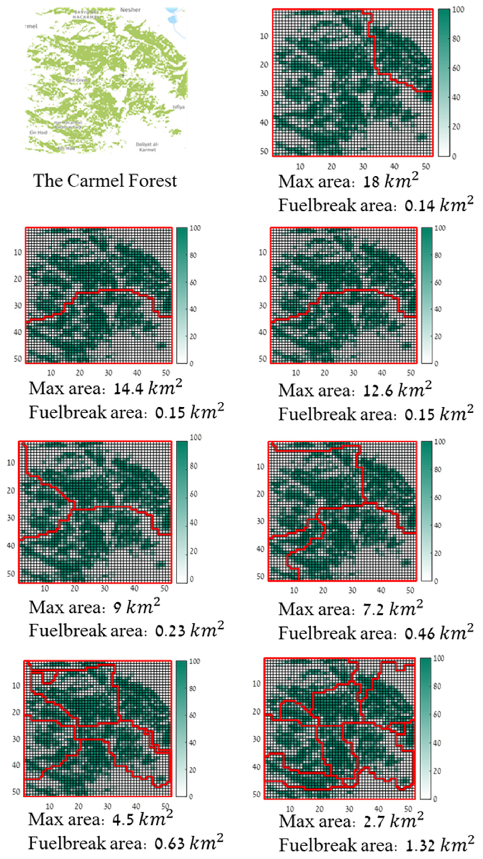
We run the algorithm on the Carmel Forest prior to the fire of December 2010. Figure 7 presents the simulation outputs for each maximal permitted forested area value. In the first three runs, the maximum permitted forestry area is large enough so that a single iteration of the algorithm and a single fuelbreak path suffice. However, when the maximum forested area is 9 k m 2 or less, two or even more fuelbreak paths are required to meet the requirements of the algorithm. As expected, the fuelbreaks in the first iterations of the algorithm go through relatively white areas—regions in which the forest was sparse to begin with. By choosing such paths, the algorithm creates a fuelbreak at a relatively low cost. As the maximum forested area permitted in each section decreases, the algorithm is forced to choose paths which go through increasingly green regions which represent dense forest areas.
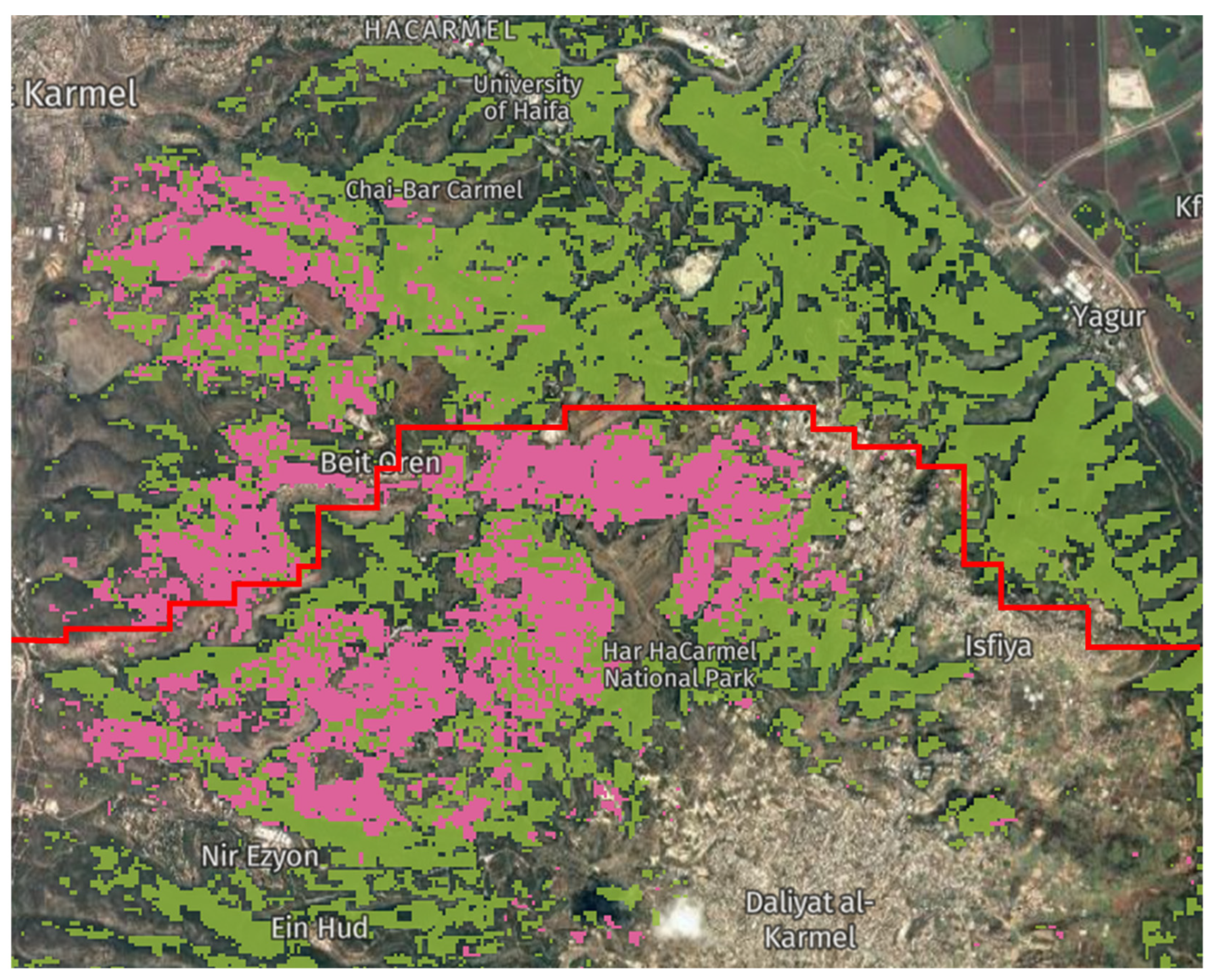
The actual burned areas in the 2010 fire are presented in Figure 8. It appears that almost every one of the suggested fuelbreaks in Figure 7 could have potentially delayed or prevented the spread of the fire to adjacent regions.
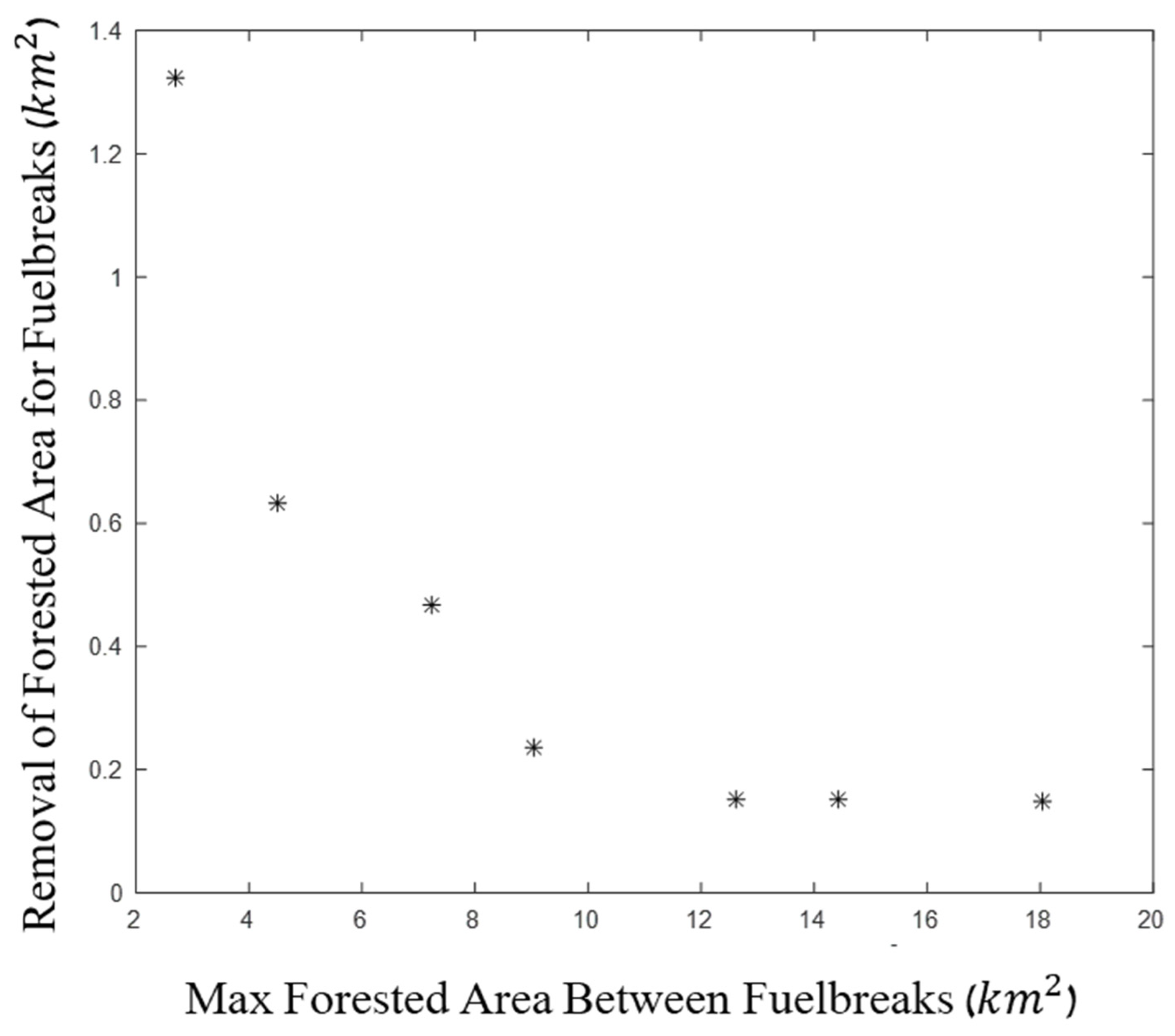
The results are summarized in Figure 9, which presents the area of the required fuelbreaks, as a function of the maximum permitted forested area. As expected, the cost of creating the fuelbreaks is higher as the maximum permitted forest areas decrease. The increase in cost is mild at first (looking from right to left) and rises exponentially after a certain value of maximum forest areas—a ‘knee’ curve. This is caused due to the fact that the first fuelbreaks in the simulation utilize areas where the forest density is low, but late fuelbreaks are required to go through dense forest areas.

3.3. Additional Forests in Israel

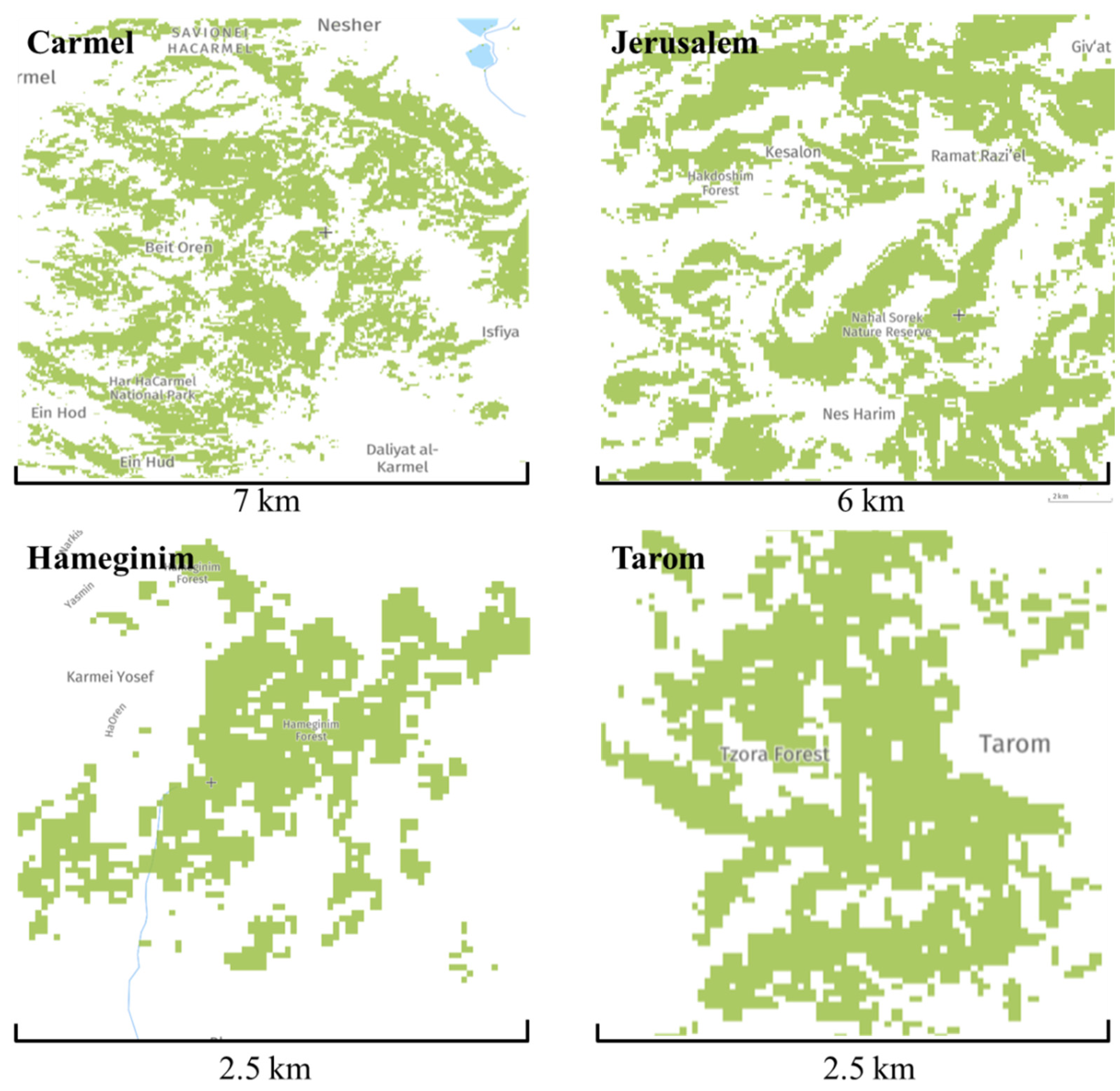
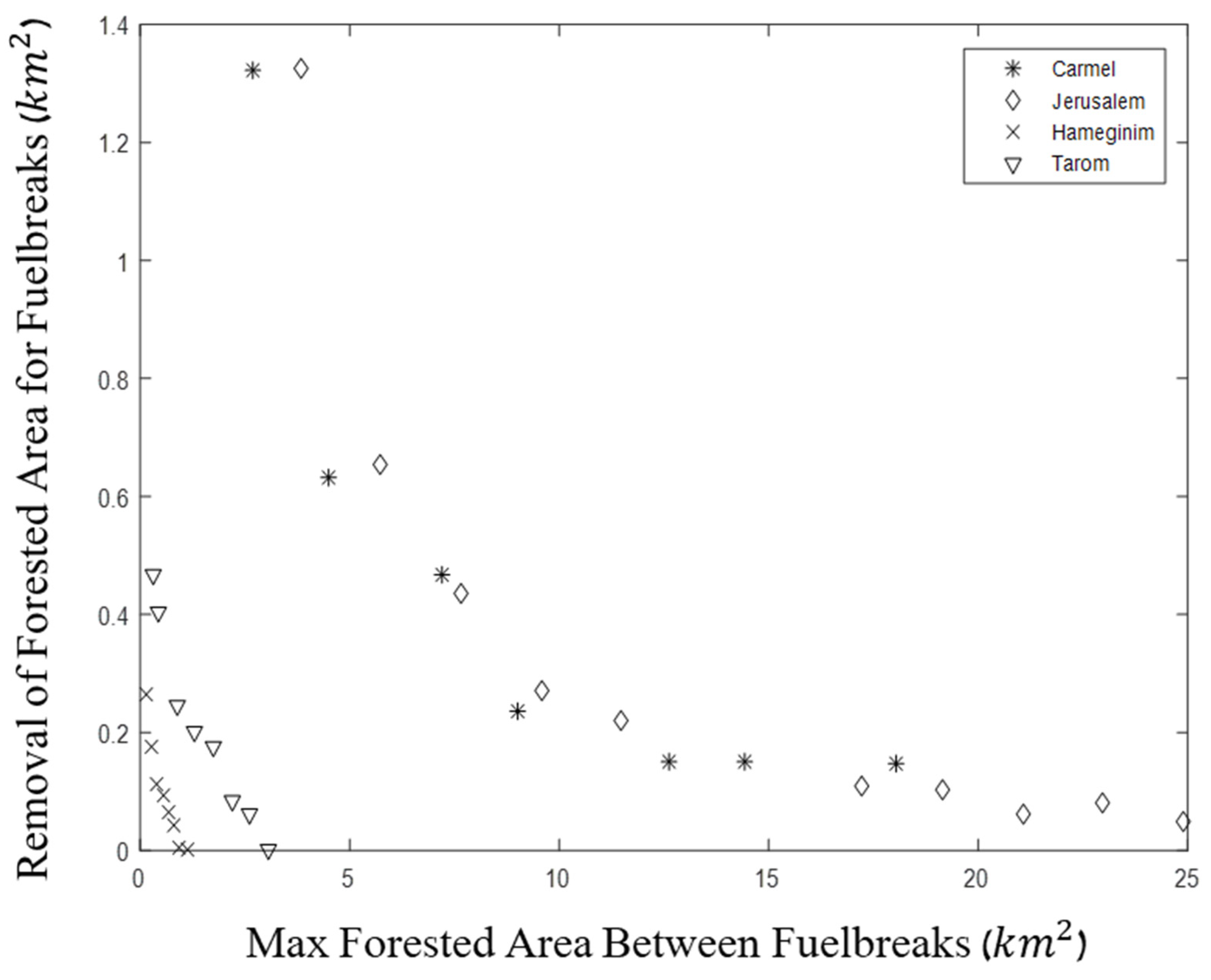
Could some forests be easier to divide than others? To examine if the ‘knee’ effect is coincidental, we run the simulation on three additional forests. Figure 10 shows the pre-processed image data for the four forests (including the Carmel) from different regions of Israel (Figure 3). The results are summarized in Figure 11: while the ‘knee’ effect is obtained for both the Carmel Forest and the forest west of Jerusalem, it is not obtained in the two relatively small Hameginim and Tarom Forests which are more homogeneously dense. The costs of fuelbreaks in the latter forests are therefore linear, in contrast to the former two where the initial fuelbreaks’ costs are low.
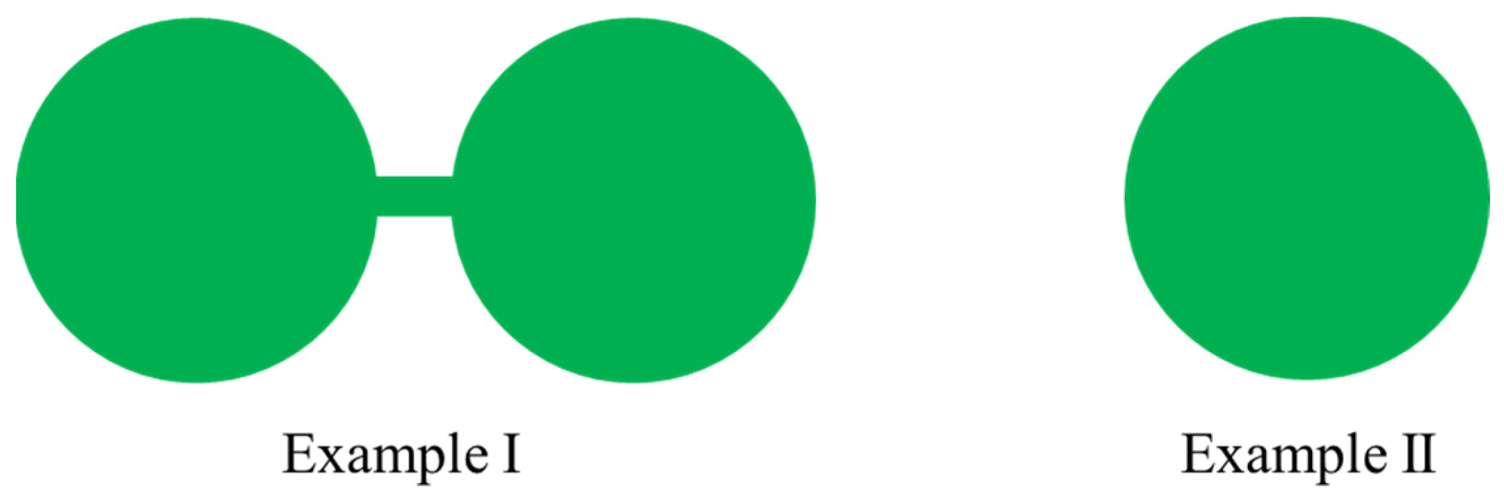
To provide a heuristic explanation for this effect, consider two forests as illustrated in Figure 12. The task of dividing the forest into two equal sections requires only a minor fuelbreak in the connecting line in Example I. In Example II, however, it would require a much more costly fuelbreak that crosses through the forest. This simple illustration demonstrates that some forests have greater potential for fuelbreak division than others. It could generally be said that homogeneous forests require more costly fuelbreaks.
A simple illustration of two different forest shapes. The task of dividing the forest into two equal sections requires only a minor fuelbreak in the connecting line in Example I. In Example II, however, it would require a much more costly fuelbreak that goes through the forest. This simple illustration demonstrates that some forests have greater potential for fuelbreak division than others.

3.4. A Tree-Economy Perspective

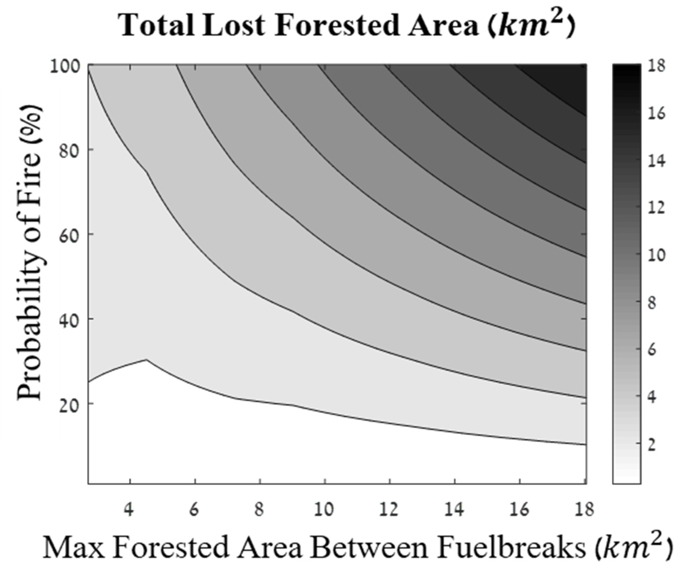
It is difficult to make the decision to create fuelbreaks due to the deforestation involved in the process; we must cut down a small part of the forest to avoid the risk of fires causing much larger deforestation in the future. The cost effectiveness of such actions is therefore a function of the probability of large-scale fires in the forest, fires that could potentially burn an entire section of the forest. We address only major fires and not partial burns because almost all of the forests burned are consumed in major fires [2,3]. If the probability of major fires is negligible, there is little sense in creating fuelbreaks; however, as this probability increases, the effectiveness of fuelbreaks increases.
Figure 13 presents the total expected forested area loss in the Carmel Forest as a function of the probability of major fires, for different possible levels of fuelbreaks (referring to the different possibilities described in Figure 9 and Figure 11). The expected forest loss is calculated as the sum of the fuelbreak cost and the expected forest loss in a major fire, which is the tree area in a forest section multiplied by the probability of a major fire:
F L = F B + P f i r e · F A
where FL is the expected total forest loss, FB is the area of the trees that must be cut down to create the fuelbreak, P f i r e is the probability of a major fire that would burn an entire section of the forest and F A is the maximum forestry area in one forest section (between fuelbreaks). The right side of the figure represents having little or no fuelbreaks. This enables us to estimate the efficiency of fuelbreaks using the ‘with and without’ principle. The expected forest loss obviously increases with the probability of fire. Consider now the complete diagram: when the probability of fire is very low, the most cost-effective solution is to implement few or no fuelbreaks and allow a low probability of large fires. As the probability increases, ‘tight’ fuelbreaks become the preferred alternative. Unfortunately, in recent years, the probability of major wildfires has gradually increased due to climate change, suggesting fuelbreaks could be an increasingly effective and necessary means of minimizing deforestation.
This demonstration is simplistic, as it does not reflect the probability of the fire burning, only part of the forest section. However, we find it to be a reasonable assumption, as the vast majority of global burned areas are burned by a small number of major fires. An additional simplistic assumption in this model is that the fuelbreak is completely effective in preventing the fire from crossing it. Despite these simplistic assumptions, we do believe that this demonstration reliably reflects the major considerations in fuelbreak planning.

4. Discussion

Fuelbreak implementation is an effective forest management tool that has proven its potential value in delaying or even stopping the spread of wildfires. However, due to their relatively high cost, the implementation of fuelbreaks has remained limited to date. Fuelbreaks can only be cost effective if they are implemented in the most crucial locations, where their potential for preventing the spread of wildfires is greatest. Identifying the most cost-effective fuelbreak paths is computationally challenging, as comparing every single potential path is impossible in forests of considerable size (e.g., [20,23,26,27]).
In this study, we proposed an algorithm for fuelbreak planning, building on Dijkstra’s shortest path algorithm. The proposed algorithm is based on a recursive application of Dijkstra’s algorithm. Each step divides the forest into two sections, one of which (at least) is at the maximum forested area as defined by the user. This process is repeated until none of the remaining sections exceeds the maximum forested area. While Dijkstra’s algorithm guarantees that each fuelbreak that is added in each step is optimal, the combined fuelbreak system is not necessarily optimal; in this sense, our proposed algorithm can be described as a greedy algorithm.
We began by applying the algorithm to two artificial forests, demonstrating its performance, followed by its application on several actual forests in Israel. We presented an extensive analysis of the algorithm’s application on the 2010 Carmel Forest, prior to the deadly December 2010 fire which claimed the lives of 44 men and women. We demonstrated the performance of the algorithm and the resulting fuelbreaks when defining several different maximal forested area values. We found that almost all fuelbreaks proposed by the algorithm (Figure 7) could have had an effect on the actual 2010 wildfire (Figure 8). While this is an anecdotal result, it demonstrates the potential of fuelbreaks in wildfire mitigation. As expected, dividing the forests into smaller sections is more costly and requires the implementation of longer fuelbreak paths. In some of the forests, we found that the first few fuelbreaks provided a significant reduction in maximum forested areas at a low cost, while additional fuelbreaks were substantially less cost effective. This decrease in the marginal cost effectiveness of fuelbreaks was not found in all forests, especially not in small and homogeneous forests (Figure 11). We conclude that in some forests, the implementation of even a few fuelbreaks has the potential of substantially decreasing wildfire risk, most likely due to the opportunity of exploiting existing gaps in vegetation and developing them into effective fuelbreaks at a relatively low cost. However, in some forests, fuelbreak planning is much more costly due to the shape of the forest and the lack of natural fuelbreaks that could assist in implementing man-made fuelbreaks (Figure 12).
Finally, the extent to which fuelbreaks should be implemented is an important question that merits further research. In the paper, we presented a simplistic model which demonstrates how the probability of a large wildfire could considerably affect the desired system of fuelbreaks. It is clear that as extreme wildfires become more frequent, fuelbreaks are becoming an increasingly effective tool and their implementation should become more common. An additional factor which should be considered when discussing fuelbreak necessity is the distribution of wildfires. Studies have demonstrated that power laws can be found in many fire size distributions [34,35]. Some scholars have identified this property as evidence of self-organization [36]. Future studies could further research the effect of fuelbreak implementation, such as those suggested in this paper, on the mechanism of highly optimized tolerance [34].
We propose several directions for future research which could build on our algorithm and advance it in several aspects. One limitation of our study was that we assumed a constant fuelbreak width. The necessary fuelbreak width should vary based on topography, vegetation type and regional meteorological characteristics. We suggest that further research is needed on the effects of these factors on a fuelbreak planning algorithm such as that suggested in this paper. One such influential factor is topography. Wildfires tend to spread faster uphill [10,37]. Fuelbreaks are also harder to construct and maintain on steep slopes [6,38]. Regional wind characteristics, including both velocity and direction, should be taken into consideration when planning fuelbreaks [39,40,41]. The effectiveness of fuelbreaks is also influenced by wind velocity; for example, strong winds could lead to spotting—burning embers lofted and transported across a fuelbreak [42]. Spotting is also affected by fuel characteristics [43], a factor that should be considered in the fuelbreak planning process. Even without spotting, wind velocity affects the probability of a fire crossing the fuelbreak; when the fire is wind-driven, the convective heat flux is a dominant mode and tends to increase with wind velocity [44]. Wind direction has a crucial effect on fuelbreak effectiveness; the ineffectiveness of fuelbreaks with respect to fires spreading in parallel directions to them is supported both empirically [17,45] and by simulations [39,46]. Although studies have found that the wind direction is not constant in all regions [47,48], its average velocity and direction should be used to weigh favorable fuelbreak directions wherever possible. Future studies could integrate these considerations into the fuelbreak planning algorithm.
Additional research could incorporate a wildfire simulation such as the WFDS [13,14] or FARSITE [49] into our model and use it to assess the spread of fires under different fuelbreak systems. Quantifying the regional wildfire risk with or without the fuelbreaks proposed by the current algorithm could validate the effectiveness of the fuelbreaks and provide a better comparison to alternative methods. Such quantification could also enable future studies to optimize the total fuelbreak area as a function of both length and width, minimizing the total required deforestation.

5. Conclusions

In this paper, we proposed an iterative Dijkstra-based fuelbreak spatial optimization algorithm. We found that the proposed method has the potential to assist in effective fuelbreak planning. Fuelbreaks were found to have a decreasing marginal cost effectiveness as the first fuelbreaks take advantage of existing paths with low-density vegetation. In addition, the implementation of fuelbreaks had more potential in some forests compared to others. We believe future research, relaxing the assumptions in the current study, could develop and improve the suggested method, increase its applicability and prove it to be a valuable fuelbreak planning tool.

Author Contributions

Conceptualization, A.S. and E.H.; methodology, A.S. and E.H.; software, A.S.; validation, E.H.; data curation, A.S.; writing—original draft preparation, A.S.; writing—review and editing, E.H.; visualization, A.S.; supervision, E.H. All authors have read and agreed to the published version of the manuscript.

Funding

This study did not receive any specific funding.

Informed Consent Statement

Not applicable.

Data Availability Statement

No new data were created in this study. Data sharing is not applicable to this article.

Acknowledgments

We thank the four anonymous reviewers and the editorial team for their careful reading of our manuscript and their many insightful comments and suggestions.

Conflicts of Interest

The authors declare that they have no conflict of interest.

References

  1. Chandrasekaran, R.; Shephard, R.W. Optimal Strategies of Fire Fighting by Firebreaks (No. ORC-66-30); California University Berkley Operations Research Center: Berkeley, CA, USA, 1966. [Google Scholar]
  2. Strauss, D.; Bednar, L.; Mees, R. Do one percent of the forest fires cause ninety-nine percent of the damage? For. Sci. 1989, 35, 319–328. [Google Scholar]
  3. Holmes, T.P.; Huggett, R.J.; Westerling, A.L. Statistical analysis of large wildfires. In The Economics of Forest Disturbances; Springer: Dordrecht, The Netherlands; Berlin/Heidelberg, Germany, 2008; pp. 59–77. [Google Scholar]
  4. Mooney, C. Fuelbreak Effectiveness: State of the Knowledge; Wildland Fire Operations Research Group 1176; Switzer Drive: Hinton, AB, Canada, 2007. [Google Scholar]
  5. Perriez, F.; Bartet, J.H.; Barthélemy, F.; Foin, P.; Battesti, J.P.; David, J.P. Rapport Relatif à la Protection Contre Les Incendies de forêt Après Les Feux de L’éTé 2003 Tome 1: Rapport Général. 2003, p. 126. Available online: https://www.vie-publique.fr/rapport/26676-la-protection-contre-les-incendies-de-foret-apres-les-feux-de-lete-2003 (accessed on 1 July 2023).
  6. Xanthopoulos, G.; Caballero, D.; Galante, M.; Alexandrian, D.; Rigolot, E.; Marzano, R. Forest fuels management in Europe. In Fuels Management—How to Measure Success: Conference Proceedings; US Department of Agriculture, Forest Service, Rocky Mountain Research Station: Fort Collins, CO, USA, 2006; Volume 41, pp. 29–46. [Google Scholar]
  7. Wang, H.H.; Finney, M.A.; Song, Z.L.; Wang, Z.S.; Li, X.C. Ecological techniques for wildfire mitigation: Two distinct fuelbreak approaches and their fusion. For. Ecol. Manag. 2021, 495, 119376. [Google Scholar] [CrossRef]
  8. Cui, X.; Alam, M.A.; Perry, G.L.; Paterson, A.M.; Wyse, S.V.; Curran, T.J. Green firebreaks as a management tool for wildfires: Lessons from China. J. Environ. Manag. 2019, 233, 329–336. [Google Scholar] [CrossRef] [PubMed]
  9. Song, H.S.; Lee, S.H. Effects of wind and tree density on forest fire patterns in a mixed-tree species forest. For. Sci. Technol. 2017, 13, 9–16. [Google Scholar] [CrossRef] [Green Version]
  10. Kim, D.W.; Chung, W.; Lee, B. Exploring tree crown spacing and slope interaction effects on fire behavior with a physics-based fire model. For. Sci. Technol. 2016, 12, 167–175. [Google Scholar] [CrossRef] [Green Version]
  11. Chung, W. Optimizing fuel treatments to reduce wildland fire risk. Curr. For. Rep. 2015, 1, 44–51. [Google Scholar] [CrossRef] [Green Version]
  12. Finney, M.A. An overview of FlamMap fire modeling capabilities. In Fuels Management—How to Measure Success: Conference Proceedings; US Department of Agriculture, Forest Service, Rocky Mountain Research Station: Fort Collins, CO, USA; Volume 41, pp. 213–220.
  13. Mell, W.; Jenkins, M.A.; Gould, J.; Cheney, P. A physics-based approach to modelling grassland fires. Int. J. Wildland Fire 2007, 16, 1–22. [Google Scholar] [CrossRef]
  14. Mell, W.; Charney, J.; Jenkins, M.A.; Cheney, P.; Gould, J. Numerical simulations of grassland fire behavior from the LANL-FIRETEC and NIST-WFDS models. In Remote Sensing and Modeling Applications to Wildland Fires; Springer: Berlin/Heidelberg, Germany, 2013; pp. 209–225. [Google Scholar]
  15. Soffer, G. After the Carmel Fire: Ecology of Fire, KKL and Government. Personal Blog. Available online: http://gilisoffer.com/WP/?p=452 (accessed on 19 July 2023).
  16. Russo, L.; Russo, P.; Siettos, C.I. A complex network theory approach for the spatial distribution of fire breaks in heterogeneous forest landscapes for the control of wildland fires. PLoS ONE 2016, 11, e0163226. [Google Scholar] [CrossRef]
  17. Ascoli, D.; Russo, L.; Giannino, F.; Siettos, C.; Moreira, F.; Firebreak and Fuelbreak. Encyclopedia of Wildfires and Wildland-Urban Interface (WUI) Fires; Springer: Dordrecht, The Netherlands; Berlin/Heidelberg, Germany, 2018; pp. 1–9. [Google Scholar]
  18. Wei, Y.; Rideout, D.; Kirsch, A. An optimization model for locating fuel treatments across a landscape to reduce expected fire losses. Can. J. For. Res. 2008, 38, 868–877. [Google Scholar] [CrossRef]
  19. Wei, Y.; Long, Y. Schedule fuel treatments to fragment high fire hazard fuel patches. Math. Comput. For. Nat. Resour. Sci. 2014, 6, 1. [Google Scholar]
  20. León, J.; Reijnders, V.M.; Hearne, J.W.; Ozlen, M.; Reinke, K.J. A Landscape-scale optimisation model to break the hazardous fuel continuum while maintaining habitat quality. Environ. Model. Assess. 2019, 24, 369–379. [Google Scholar] [CrossRef]
  21. Hof, J.; Omi, P.N.; Bevers, M.; Laven, R.D. A timing-oriented approach to spatial allocation of fire management effort. For. Sci. 2000, 46, 442–451. [Google Scholar]
  22. Finney, M.A. A computational method for optimising fuel treatment locations. Int. J. Wildland Fire 2007, 16, 702–711. [Google Scholar] [CrossRef] [Green Version]
  23. Wei, Y. Optimize landscape fuel treatment locations to create control opportunities for future fires. Can. J. For. Res. 2012, 42, 1002–1014. [Google Scholar] [CrossRef]
  24. Minas, J.P.; Hearne, J.W. An optimization model for aggregation of prescribed burn units. TOP 2016, 24, 180–195. [Google Scholar] [CrossRef]
  25. Rachmawati, R.; Ozlen, M.; Reinke, K.J.; Hearne, J.W. An optimisation approach for fuel treatment planning to break the connectivity of high-risk regions. For. Ecol. Manag. 2016, 368, 94–104. [Google Scholar] [CrossRef] [Green Version]
  26. Minas, J.P.; Hearne, J.W.; Martell, D.L. A spatial optimisation model for multi-period landscape level fuel management to mitigate wildfire impacts. Eur. J. Oper. Res. 2014, 232, 412–422. [Google Scholar] [CrossRef]
  27. Minas, J.; Hearne, J.; Martell, D. An integrated optimization model for fuel management and fire suppression preparedness planning. Ann. Oper. Res. 2015, 232, 201–215. [Google Scholar] [CrossRef]
  28. Acuna, M.A.; Palma, C.D.; Cui, W.; Martell, D.L.; Weintraub, A. Integrated spatial fire and forest management planning. Can. J. For. Res. 2010, 40, 2370–2383. [Google Scholar] [CrossRef]
  29. Palma, C.D.; Cui, W.; Martell, D.L.; Robak, D.; Weintraub, A. Assessing the impact of stand-level harvests on the flammability of forest landscapes. Int. J. Wildland Fire 2007, 16, 584–592. [Google Scholar] [CrossRef]
  30. Global Forest Watch. Available online: https://www.globalforestwatch.org/ (accessed on 19 July 2023).
  31. Wittenberg, L.; Malkinson, D.; Beeri, O.; Halutzy, A.; Tesler, N. Spatial and temporal patterns of vegetation recovery following sequences of forest fires in a Mediterranean landscape, Mt. Carmel Israel. Catena 2007, 71, 76–83. [Google Scholar] [CrossRef]
  32. Gaba, E. Geography of Israel. Available online: https://en.wikipedia.org/wiki/Geography_of_Israel (accessed on 1 July 2023).
  33. Dijkstra, E.W. A note on two problems in connexion with graphs. Numer. Math. 1959, 1, 269–271. [Google Scholar] [CrossRef] [Green Version]
  34. Carlson, J.M.; Doyle, J. Highly optimized tolerance: A mechanism for power laws in designed systems. Phys. Rev. E 1999, 60, 1412. [Google Scholar] [CrossRef] [PubMed] [Green Version]
  35. Moritz, M.A.; Hessburg, P.F.; Povak, N.A. Native fire regimes and landscape resilience. In The Landscape Ecology of Fire; Springer: Dordrecht, The Netherlands, 2010; pp. 51–86. [Google Scholar]
  36. Malamud, B.D.; Morein, G.; Turcotte, D.L. Forest fires: An example of self-organized critical behavior. Science 1998, 281, 1840–1842. [Google Scholar] [CrossRef] [Green Version]
  37. Laschi, A.; Foderi, C.; Fabiano, F.; Neri, F.; Cambi, M.; Mariotti, B.; Marchi, E. Forest road planning, construction and maintenance to improve forest fire fighting: A review. Croat. J. For. Eng. J. Theory Appl. For. Eng. 2019, 40, 207–219. [Google Scholar]
  38. Thomas, G.; Rosalie, V.; Olivier, C.; Antonio, L.P. Modelling forest fire and firebreak scenarios in a mediterranean mountainous catchment: Impacts on sediment loads. J. Environ. Manag. 2021, 289, 112497. [Google Scholar] [CrossRef]
  39. Finney, M.A. Design of regular landscape fuel treatment patterns for modifying fire growth and behavior. For. Sci. 2001, 47, 219–228. [Google Scholar]
  40. Zinck, R.D.; Grimm, V. Unifying wildfire models from ecology and statistical physics. Am. Nat. 2009, 174, E170–E185. [Google Scholar] [CrossRef]
  41. Thakar, V. A spatial Optimization Approach to Finding Locations for Wildfire Fuel Treatments. Ph.D. Thesis, The University of Texas, Dallas, TX, USA, 2017. [Google Scholar]
  42. Seto, D.; Jones, C.; Trugman, A.T.; Varga, K.; Plantinga, A.J.; Carvalho, L.M.; Thompson, C.; Gellman, J.; Daum, K. Simulating potential impacts of fuel treatments on fire behavior and evacuation time of the 2018 Camp Fire in northern California. Fire 2022, 5, 37. [Google Scholar] [CrossRef]
  43. Storey, M.A.; Price, O.F.; Bradstock, R.A.; Sharples, J.J. Analysis of variation in distance, number, and distribution of spotting in Southeast Australian wildfires. Fire 2020, 3, 10. [Google Scholar] [CrossRef]
  44. Khan, N.; Moinuddin, K. The role of heat flux in an idealised firebreak built in surface and crown fires. Atmosphere 2021, 12, 1395. [Google Scholar] [CrossRef]
  45. Prior, K.W. The Balmoral Forest Fire. N. Z. J. For. 1958, 7, 35–50. [Google Scholar]
  46. Marshall, G.; Thompson, D.K.; Anderson, K.; Simpson, B.; Linn, R.; Schroeder, D. The impact of fuel treatments on wildfire behavior in North American boreal fuels: A simulation study using FIRETEC. Fire 2020, 3, 18. [Google Scholar] [CrossRef]
  47. Shmuel, A.; Heifetz, E. Re-examining the assumption of dominant regional wind and fire spread directions. Int. J. Wildland Fire 2022, 31, 480–491. [Google Scholar] [CrossRef]
  48. Zhang, L.; Li, Q.; Guo, Y.; Yang, Z.; Zhang, L. An investigation of wind direction and speed in a featured wind farm using joint probability distribution methods. Sustainability 2018, 10, 4338. [Google Scholar] [CrossRef] [Green Version]
  49. Finney, M.A. FARSITE, Fire Area Simulator—Model Development and Evaluation (No. 4); US Department of Agriculture, Forest Service, Rocky Mountain Research Station: Berkeley, CA, USA, 1998.
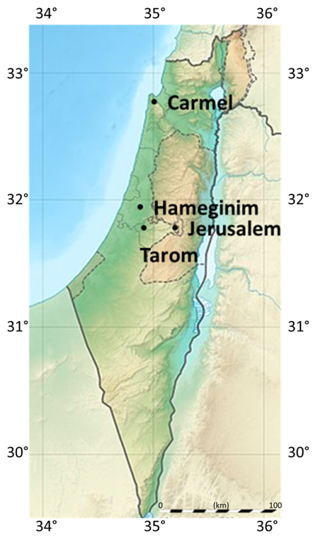
Figure 1. Forest locations in Israel. Locations of the four Israeli forests on which we applied the algorithm. The 2010 Carmel wildfire was the deadliest in the history of Israel, claiming the lives of 44 men and women. Source: [32].
Fire 06 00295 g001
Figure 2. Carmel Forest vegetation. The pictures were obtained from Naama Tessler (2010). Both pictures were captured shortly after the 2010 Carmel Forest fire. Picture (a) includes unburned vegetation while Picture (b) includes both burned and unburned vegetation.
Fire 06 00295 g002
Figure 3. Data for Carmel’s pre-2010 fire forestry terrain. Source: [30].
Fire 06 00295 g003
Figure 4. Image processing. At the first image processing stage (a), the forest image is processed to the best possible resolution. The size of each pixel is calculated by dividing the total length of the forest by the number of pixels in each axis. At the second stage (b), the pixel size is changed to the desired fuelbreak width. The total forestry area in each pixel is calculated by summing the number of initial pixels within it that had the value of 1 in the previous stage (a).
Fire 06 00295 g004
Figure 5. Example of an algorithm run. The original forest contains 67 forestry cells. In this example, forested pixels are binary (1 for forested pixels and 0 for non-forested pixels). We run the algorithm so that each forest area contains at most 60 forestry cells. The algorithm finds the simple solution (red line) of a fuelbreak where no trees are located in the first place (white squares), so that the total deforestation cost is zero.
Fire 06 00295 g005
Figure 6. Second example of an algorithm run. The original forest contains 530 forest units. We run the algorithm so that each forest area contains at most 200 forest units. The algorithm finds the solution of a fuelbreak (red lines) in two iterations (two paths), whose total cost is 70 forest units.
Fire 06 00295 g006
Figure 7. The algorithm runs for the Carmel Forest. Each pixel in the matrix represents an area of 200 × 200 m (0.04 k m 2 ). The percent of forestry area in each pixel is represented by its color, reaching a maximal value of 0.04 k m 2 .
Fire 06 00295 g007
Figure 8. Burned areas in the 2010 Carmel wildfire. Burned areas are marked in pink and forested unburned areas in green. The red line presents the suggested fuelbreak for the pre-wildfire forest when the maximum burned area is defined to be 14.4 or 12.6 k m 2 . Source: [30].
Fire 06 00295 g008
Figure 9. Summary of the Carmel Forest run results. The analysis presents a summary of the total deforestation required for creating fuelbreaks as a function of the maximum permitted tree area in each forest section. The actual paths are described in Figure 7.
Fire 06 00295 g009
Figure 10. The figure describes additional forests in which the algorithm was examined. The locations of these forests is presented in Figure 3. Source: [30].
Fire 06 00295 g010
Figure 11. Summary of results for additional forests. The analysis presents a summary of the total cut deforestation area required for creating fuelbreaks as a function of the maximum permitted forestry area in each forest section. A ‘knee’ effect is obtained in both the relatively large Carmel Forest and the forest west of Jerusalem. However, the effect is not obtained for the smaller Hameginim and Tarom Forests. These two smaller forests have less dividing potential since they are homogeneously dense, so that even minor fuelbreaks are relatively costly.
Fire 06 00295 g011
Figure 12. A simple illustrations of different forest shapes.
Fire 06 00295 g012
Figure 13. A tree-economy perspective of fuelbreaks’ utility. The figure presents the total expected tree loss in the Carmel Forest as a function of the probability of major fires, for the different possible levels of fuelbreaks presented in Figure 6 and Figure 8.
Fire 06 00295 g013
Disclaimer/Publisher’s Note: The statements, opinions and data contained in all publications are solely those of the individual author(s) and contributor(s) and not of MDPI and/or the editor(s). MDPI and/or the editor(s) disclaim responsibility for any injury to people or property resulting from any ideas, methods, instructions or products referred to in the content.