Abstract
Few fires are known to have burned the tundra of the Arctic Slope north of the Brooks Range in Alaska, USA. A total of 90 fires between 1969 and 2022 are known. Because fire has been rare, old burns can be detected by the traces of thermokarst and distinct vegetation they leave in otherwise uniform tundra, which are visible in aerial photograph archives. Several prehistoric tundra burns have been found in this way. Detection of tundra fires in this sparsely populated and remote area has been historically inconsistent and opportunistic, relying on reports by aircraft pilots. Fire reports have been logged into an administrative database which, out of necessity, has been used to scientifically evaluate changes in the fire regime. To improve the consistency of the record, we completed a systematic search of Landsat Collection 2 for the Brooks Range Foothills ecoregion over the period 1972–2022. We found 57 unrecorded tundra burns, about 41% of the total, which now numbers 138. Only 15% and 33% of all fires appear in MODIS and VIIRS satellite-borne thermal anomaly products, respectively. The fire frequency in the first 37 years of the record is 0.89 y−1 for natural ignitions that spread ≥10 ha. Frequency in the last 13 years is 2.5 y−1, indicating a nearly three-fold increase in fire frequency.
Keywords:
Landsat; tussock; Eriophorum vaginatum; wildfire; thermokarst; fire regime; MODIS; VIIRS; thermal anomaly 1. Introduction
The fire regime of tundra north of the Brooks Range on the Arctic Slope of Alaska, USA is not well understood compared to other temperate regions in which fire activity is more common and historical and proxy records of old burns are better documented. Years often pass without a reported ignition in this vast and essentially roadless region of tundra that occupies ≈ 170,000 between 68 and 70° N. Because fires have been historically rare and small, the region may serve as a bellwether for changes in fire frequency and burned area due to the warming climate [1,2]. In the 1970s, the tundra was regarded as a largely fire-free ecosystem [3,4], although recent studies have demonstrated that large burns have occurred episodically [5,6,7]. The recorded history of fire on the Arctic slope begins in 1969 and comprises only 90 documented fires; its brevity limits our understanding of how fire frequency, size, duration, severity, and other aspects of the fire regime may be changing.
Recorded fires in the early part of the record were most often reported by aircraft pilots. Subsequent dispatch of surveillance flights by fire management agencies depended on weather and fire activity elsewhere in the more populated boreal forests south of the Brooks Range [3,8]. Routine surveillance flights have not been prioritized in this region where relatively few fires occur, with the result that many fires have never been detected.
Fires are logged into an “official” fire database currently maintained by the Alaska Interagency Coordinating Center (AICC database). Despite the purpose of the AICC database as an administrative record, it has necessarily been used in scientific contexts to evaluate changes in the fire regime, e.g., [5,9,10,11,12,13,14], due to the absence of better information. While the record suggests that fires are becoming more frequent, simultaneous improvements in detection technology and increasing human presence in the region confound interpretation of these data.
Evidence accumulated by the authors over roughly the last decade suggests that the record is incomplete and that many tundra fires have passed unnoticed. Tundra fires often result in rapid and dramatic ground thermokarst due to thawing permafrost and melting ground-ice features, vegetation greening, and an increase in the stature and abundance of tall shrubs, particularly on ice-rich eolian loess (yedoma), demonstrating the potential to “discover” old fires long after the fire event using archival aerial and remote sensing imagery [15]. In this way, old burns have been found that predate 1940s-era aerial photography [7]. Two prehistoric burns are extremely large, similar in size to the 104,000 ha Anaktuvuk River Fire in 2007, and have been dated to a hundred years old or more [7,16]. Efforts to gather more information about these prehistoric fires by looking at them in sequences of archived imagery have revealed yet more unrecorded fires. Jones et al. [7] discovered eight unrecognized burns from the 1985 and 2010 fire seasons using aerial photographs and remote sensing imagery. These results convince us that a systematic search of remote sensing collections could yield a significant update to the AICC database, which would be a valuable addition in light of the scientific scrutiny the fire regime of the Arctic Slope has been receiving over the last decade, e.g., [1,13,14,17]. Augmentation of the known history of fire improves the ability to monitor biophysical changes to the landscape and address the management not only of wildfires but of vegetation, wildlife, and other physical and biological resources in an arctic ecosystem that is rapidly responding to the warming climate [2]. In this article, we document our methods and present the results of a systematic search of Landsat scenes over the last 51 years for the Brooks Range Foothills ecoregion, supplemented with information about several other prehistoric or poorly documented fires on the Arctic Slope.
2. Materials and Methods
The Arctic Slope consists of three ecoregions; of these, two have recorded fires, namely, the Beaufort Coastal Plain and the Brooks Range Foothills [18]. The Brooks Range Foothills is the area north of the mountains and south of the network of thaw ponds and lakes that characterizes the Beaufort Coastal Plain (Figure 1).
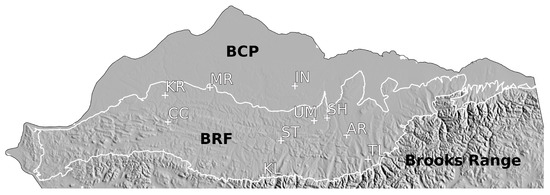
Figure 1.
Map of the Arctic Slope and the Brooks Range Foothills ecoregion (BRF) study area (white outline) [18]. BCP = Beaufort Coastal Plain ecoregion. White abbreviations are places mentioned in the text: KR, MR, ST, and SH are the Ketik River, Meade River, Starfish Bluff, and Shivugak Bluff prehistoric burns, respectively; CC = Carbon Creek drainage, AR = Anaktuvuk River Fire, UM = Umiat, IN = Inigok, TL = Toolik Lake.
In this paper, we consider three general categories of unrecorded burns. Fires with ignition date that be bracketed between two aerial photographs or Landsat scenes are called “record-worthy fires” or simply “unrecorded fires”, as they are the most numerous and the main emphasis of this article. Fires that appear in the earliest aerial photographs (late 1940s) are called “prehistoric fires”. Last, burns of a descriptive nature that are missing basic spatial and/or temporal information are called “anecdotal fires.” Only record-worthy burns can be appended to the AICC database, as the year of ignition must be known. Prehistoric burns can provide useful information, because fire effects may be quantified and monitored through the history of remote sensing datasets even when the age of the burn remains unknown. Finally, anecdotal burns can offer qualitative information.
Burns were discovered in two ways: casually (e.g., field observation or inspection of imagery for other purposes) and through systematic search.
2.1. Casual Search
Through our efforts over the past decade to learn about Arctic Slope fires, we have kept informal notes on any unrecorded fires for eventual upload to the AICC database. Several fires were found using Google Earth Pro (https://www.google.com/earth/versions/ accessed on 15 January 2023) by searching for uncharacteristic thermokarst or vegetation greening against a uniform backdrop of tundra. Suspected burns were then confirmed in aerial images (c. 1948 to 1980s) and/or Landsat scenes [19] in the United States Geological Survey (USGS) Earth Explorer web application (https://earthexplorer.usgs.gov/ accessed on 22 January 2023).
2.2. Systematic Search
A systematic search was begun in late 2022. We found that burns could easily be found in the Landsat Collection, which has an exceptionally long history extending back to 1972. In order to keep our project manageable, we selected a geographic search area smaller than the entire Arctic Slope. The only ecoregion with an appreciable natural fire regime is the Brooks Range Foothills ecoregion of Muller et al. [18]. Our systematic search did not start at the beginning and progress forward; rather, we searched through tiers of fire seasons consisting of one random year from each decade of the Landsat record. Each tier was searched before the next was started. We used this approach because we assumed that search pattern recognition and observer proficiency would increase with the number of scenes searched. The approach would spread potential observer bias over the entire record. The burn signature varied somewhat by the scene characteristics of each Landsat mission, with the many recorded fires that we encountered serving to calibrate the eye.
Landsat scenes over the 51 years between 1972 and 2022 were visually searched in USGS Earth Explorer by a single observer. Late-season scenes for August and September were searched first, as these provide the greatest chance of seeing burns from within the previous few months; however, in the study region these months are climatically cloudy. While June and July scenes are more likely to be cloud-free, they are more likely to show burns from the previous season. Fires were conspicuous into the second and often the third or fourth season post-fire (Figure 2). Scenes from Landsat 4–9, Collection 2, U.S. “Analysis Ready Data”, were preferred; however, these were not available for the earliest decades, for which the highest available Collection 2 scenes were searched. The Landsat Collection 2 Level 3 Burned Area Science Product is not available in Alaska [20]. Landsat scenes were unavailable or insufficient to cover the search area for seven years in the 1990s (1990, 1991, 1993, 1994, 1996, 1997, 1998) due to well-known gaps in data archiving in the northern high latitudes [21]. Enough scenes were examined in each available season to spatially cover the search area of the Brooks Range Foothills at least one time. More often, two or more overlapping scenes were examined to reduce the chance of masking by cloud cover or other scene quality artifacts. Landsat 7 scenes had incomplete coverage resulting from “Scan Line Corrector Failure” (Figure 2) exhibited beginning in June 2003, affecting 16% of searched scenes between 2003 and 2015. Fires smaller than about 10 ha may have been masked in between the covered swaths. The resolution of Landsat 1 scenes was poor relative to Landsat 9, though good enough to see burns of about 10 or more hectares, e.g., the 1972 Ceratodon burn. More than 75% of scenes were Mission 4 or greater (Table 1). The number of scenes searched per year ranged up to 32, with an average of 17.
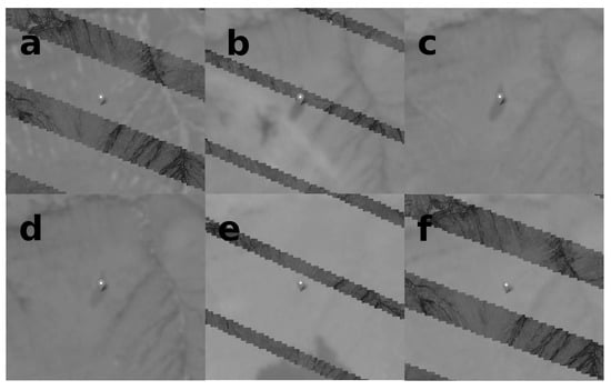
Figure 2.
Example of an unrecorded tundra fire, the 2010 Lepidozia fire (4.5 ha), in a sequence of Landsat scenes overlaying background imagery. (a) 5 June 2010, prior to ignition. (b) 12 June 2010, several days after ignition. (c) 23 August 2010 and (d) 7 June 2011; these images are ideal and confirm the burn. (e) 9 August 2011 and (f) 13 August 2012; the burn has faded. These scenes illustrate various scene defects, such as incomplete swaths in Landsat 7 due to “Scan Line Corrector Failure” (a,b,e,f), obscuring white cloud in the air (the white wisp south of the burn in (b)), and dark cloud shadow on the ground (b,e). There is snow in the watertracks in a and d. The images are from Landsat Mission 5 (c,d) and Mission 7 (a,b,e,f). The edge length of each scene is 2 km. The image contrast has been increased for clarity.

Table 1.
Landsat search summary.
In order to be confirmed, burns had to appear in at least two scenes (to prevent a false positive), be absent in a prior scene, be unrelated to the permanent landscape features, and be absent from the AICC database. Burns always appear suddenly and then gradually disappear over the next few seasons (e.g., Figure 2). They can be distinguished from ephemeral cloud shadows by their color and persistence in two or more following scenes. We found one retrogressive thaw slump which appeared to be a burn; however, it continued to grow through the next few seasons and was visible for a decade or more. We are unaware of other natural disturbances to the tundra that may resemble a burn.
Date of ignition was bracketed between the latest scene in which the burn did not appear and the earliest scene in which it did. Typically, dates could be narrowed down to within a month depending on cloud cover. Ten fires could not be bracketed within the same year because prior scenes were not available. One 1972 burn was bracketed using a 1971 aerial photograph. We are confident of the stated ignition year of the other fires because they do not appear in any late season scene of the prior year. For burns after 1985, the ignition date could often be determined to the day using lightning records (Alaska Lightning Detection Network, Bureau of Land Management, Alaska Fire Service https://fire.ak.blm.gov/predsvcs/maps.php accessed on 6 November 2022). In certain cases, the ignition date of a nearby known fire was assigned to an unrecorded fire if it fit the scene dates and lightning data. The ignition dates for four fires were established by thermal anomalies detected by the Moderate Resolution Imaging Spectroradiometer (MODIS) Collection 6.1 (MCD14ML) standard quality Thermal Anomalies/Fire Locations product and/or the Visible Infrared Imaging Radiometer Suite (VIIRS) (VNP14IMGTML) 375 m standard Active Fire and Thermal Anomalies product. Both datasets were downloaded from the National Aeronautics and Space Administration’s Fire Information for Resource Management System (https://firms.modaps.eosdis.nasa.gov/ accessed on 6 November 2022). The 2013 Paneak Fire fire was discovered based on thermal anomalies. Two fires spanned the Brooks Range Foothills ecoregion border, and were included: the 2013 Avalik River (unrecorded) and the 1977 “AIN SSE 38” Fire (recorded, known as the Kokolik River fire [22,23]). We populated the “Discovery Date” field in the AICC database with the exact ignition date if known, or otherwise the scene date in which the burn first appears, i.e., was discovered. All dates used to bracket ignition are listed in Table A1 in Appendix A. Burn size was measured using the “Measure Area” tool in QGIS (version 3.10.4 https://qgis.org accessed on 6 November 2022). Each burn is reported in Table A1 and Table A2 with the latitude and longitude of the approximate centroid, fire season, the exact ignition date or range of dates, fire size, and identification for a representative Landsat scene or aerial photograph. The burns discovered using these methods are noted in the AICC database with the digital object identifier of this article in the comments field.
3. Results
790 Landsat scenes representing the 51-year period from 1972 to 2022 were searched. Unrecorded fires were found in 17 of 44 seasons with available scenes. We found 60 record-worthy burns, or 40% of the total number of known fires on the Arctic Slope, which now numbers 150 (Table A1 and Table A2 and Figure 3). The burns do not add very much area, amounting to only 1685 , or 1% of the known total for the Arctic Slope, ≈169,000 ha. The burns range in size from 0.04 to 279 , with a median of 7.6 (Figure 4). The ignition dates of 31 burns could be confidently dated to a single day based on lightning records, thermal anomalies, or the ignition date of adjacent recorded fires. All burns except the 1977 Inigok and 2016 Point Lay Fires are assumed to have ignited by lightning. The large numbers of fires and area burned in certain years reflect the episodic nature of fire seasons in arctic and boreal ecosystems (Figure 3). Most ignitions occurred in 2010 (n = 19), 2013 (n = 10), and 1985 (n = 4). The area burned was greatest in 1985, at 397 ha (Figure 5).
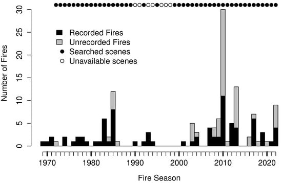
Figure 3.
Landsat scene availability and number of recorded and unrecorded fires in the Brooks Range Foothills ecoregion.
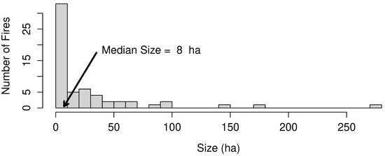
Figure 4.
Distribution of unrecorded burn sizes.
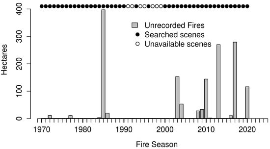
Figure 5.
Area burned in unrecorded fires by season in the Brooks Range Foothills ecoregion.
In our systematic search area of the Brooks Range Foothills ecoregion, we found 57 of the 60 record-worthy burns (Figure 3 and Figure 6). For comparison, there were previously 81 recorded fires.
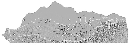
Figure 6.
Locations of recorded (pluses) and unrecorded (circles) tundra burns. The area depicted is the same as in Figure 1. The Brooks Range Foothills ecoregion is outlined in white.
Recorded and unrecorded burns in the Brooks Range Foothills were cross-referenced with MODIS and VIIRS thermal anomalies [24]. Overall, the fire detection rate for MODIS was 15% and that of VIIRS was 33% (Table 2). Most fires associated with thermal anomalies were present in the AICC database, although we found one that was not. There were no thermal anomalies for most unrecorded fires.
Table 2.
Thermal anomaly detection rates in the Brooks Range Foothills ecoregion by MODIS and VIIRS.
4. Discussion
4.1. Unrecorded Fires
One of our motivations for this study was to improve the basis for assessing changes in the fire regime of the Brooks Range Foothills ecoregion in the most unbiased way possible. Searching the Landsat Collection alleviates the inconsistent and opportunistic legacy of discovery that has existed in the AICC database to date. While we acknowledge that our systematic search does not completely eliminate bias—for instance, scenes from the Landsat 1 mission do not have the resolution or temporal coverage of later missions, and scenes for seven seasons in the 1990s are unavailable in our search area—the assumption that the entire record has been searched in a systematic way is now met. We are confident that the locations and sizes of the unrecorded fires are more accurate than the set of recorded fires in the AICC database.
Early records in the AICC database are often inaccurate or sparse in detail [8]. For example, the first recorded fire, the 1969 Killik Fire, a burn of ≈1600 ha, was never mapped due to fire activity elsewhere [3]. As often happens in an active fire season, firefighting resources and aircraft are directed to the most critical fires and others are left to burn. We were unable to find traces of this burn in 1970s-era aerial photographs or in 1972 Landsat scenes. In the active 1985 season, we found that the locations of four large burns were off by 8 to 19 km. In fact, the coordinates were so far off that we were initially led to believe that the burns we were seeing in the Landsat scenes were new unrecorded fires. They were reported by pilots who, we assume, radioed their own latitudes and longitudes or vague descriptions with reference to this creek or that river, e.g., the “rough coordinates” of the several so-named “WAY UP N” burns mentioned in the original paper fire reports. Weather delayed the surveillance of these burns by fire management aerial observers, and although they were eventually mapped, the “rough” coordinates of the ignition points do not appear to have been updated to reflect the true fire locations. Crude perimeters were hand-drawn on topographical maps, and burned areas were coarsely estimated to the nearest hundred acres (40 ha). Weather often determined the times and places at which reconnaissance could occur, illustrated perhaps by the absence in the record of the 173 ha Titaluk Fire. While this level of detail satisfies the administrative requirements of fire management, it is often insufficient for scientists interested in studying fire effects to find old burns on the ground.
The trend in Figure 3 suggests that, aside from highs and lows in fire numbers for individual years, there appears to be a decadal-scale period of quiescence in 1987–2002. No unrecorded fires were found in these 16 years. This hiatus is partly explained by the seven years of unavailable Landsat scenes in the 1990s; however, it is reflected in the small number of recorded fires as well, with only seven. Remarkably, two of these, the 1993 DCKN190 and DCKN178 fires, are the second-largest and fourth-largest fires on the Arctic Slope, accounting for about 40,000 ha of burned area. This anomalous period characterized by low fire frequency and high area burned is not well explained.
The numbers of fires on either side of the hiatus are unbalanced, suggesting a trend of increasing fire frequency. Considering both recorded and unrecorded fires that occurred in the systematic search timeframe (1972–2022) and search area (Brooks Range Foothills), excluding human-caused ignitions, and looking at fires ≥10 ha to reduce bias in the size of fires that could be detected in the early Landsat record (n = 67), the year that divides the number of fires in half (the median year) is 2009, occurring nearly three-quarters of the way through the analysis period. Half of the fires occurred in the first 37 years of the record, while the other half occurred in the last 13 years. These values correspond to fire frequencies of 0.89 and 2.5 y−1, respectively, in the Brooks Range Foothills. This nearly three-fold increase in rate would not have been apparent without our systematic search.
We expected that the use of satellite-borne sensors would have decreased the omission rate in the last twenty years, and that there would consequently be fewer unrecorded fires. However, we found the opposite. Only seven of the 57 unrecorded burns in the Brooks Range Foothills occurred prior to the advent of MODIS on the Arctic Slope in 2002, or 12%. In other words, nearly nine of ten unrecorded fires that we found occurred in the era of MODIS and/or VIIRS. This pattern suggests that the omission rate of satellite-based detection is high [25]. Our cross-referencing indicates that MODIS and VIIRS missed 85% and 67% of fires, respectively. Most tundra fires are small (median 9 ha), and likely burn for only a single burn period, which may occur between satellite passes with insufficient fireline intensity or radiative power to be detected. The pattern also suggests that, assuming our systematic search of the Landsat record was complete and consistent, the increasing frequency of fires is real and cannot be explained by improvements in remote sensing technology.
The impacts of increasing fire frequency in an ecosystem in which fire has been a relatively novel disturbance [5,6] are complex and incompletely known; however, researchers are currently working to address various fire effects, e.g., ground heat flux and thermokarst, hydrological changes, increasing prominence of atypical plant and lichen taxa, and shrub expansion [15,17,26,27,28,29,30,31]. Fire appears to accelerate changes to the tundra that are already occurring in response to climate change [17].
4.2. Notes on Selected Fires and Seasons
4.2.1. 1972
Searching for the 1969 Killik Fire, we found the 1972 Ceratodon fire in one of the earliest Landsat scenes available. Instead of a prior scene to bracket the ignition date, we were able to use a 1971 aerial photograph. While we assigned an ignition date of 1972, we acknowledge that this burn could have ignited in late July or August of 1971; its dating has the lowest confidence of any of the unrecorded fires.
4.2.2. 1977 Inigok
Two ignitions are associated with oil exploration and the construction of the airstrip at Inigok. An image in Gryc [32] (Figure 38.6) is captioned “Darker area along road was result of tundra fire in 1977”. This burn was located in the Landsat Collection. This was an active fire season on the Arctic Slope and the Seward Peninsula [17,23,33,34].
The second fire is depicted in a photographic figure in a 1991 report by Crory [35]. The image suggests that this fire of about 3 ha was on the other side of the airstrip. His Figure 118 is captioned, “... Note thermal effect of fire at old camp site in foreground.” No other information is provided, and our search of Landsat scenes was not successful. This burn is therefore not record-worthy.
4.2.3. 1985 Fire Season
There were eight recorded fires in three clusters in 1985. The coordinates of the four largest of these burns were in error by many kilometers. The first cluster of two burns was discovered in late June southwest of Umiat along the Colville River. Two burns of 21 and 26 ha appear in the Landsat record; however, these were found to be 6 to 18 km away from the listed coordinates for the two most likely matches in the AICC database, UMT-SW-10 and UMT-SW-20, of 8.1 and 0.2 ha, respectively. Despite these inaccuracies in location and size, it is apparent that these are the same fires, and the AICC database has been updated.
The second cluster was discovered in early August in the Maybe Creek drainage, a fork of the Ikpikpuk River. Again, the recorded coordinates of the two largest burns, WAY-UP-N-#2 and WAY-UP-N-#4, were inaccurate, 8–13 km away from the burns appearing in Landsat scenes. The coordinates were updated and estimates of burned area were reduced from 809 ha and 324 ha (2000 and 800 acres) to 505 and 181 ha, respectively.
Jones et al. [7] found a third cluster of three fires of 44-92 ha west of the Meade River that did not correspond to any recorded fires; these are the Avens, Cladina, and Vaccinium fires. A last burn, Titaluk, was casually found in Google Earth by its conspicuous pattern of thermokarst and greening. This isolated burn was the second-largest that we found, at 173 ha. It was confirmed at the time in an aerial photograph (Table A2).
4.2.4. 2010 Season
The 2010 season was notable for many small and early ignitions in the eastern part of the Brooks Range Foothills. Recorded fires (n = 11) were small (median 0.2 ha), except for two that grew to >100 ha. The median size of unrecorded burns (n = 19) was 2.9 ha, and the largest was 36 ha. Many of these fires ignited in a wave of lightning 8–9 June, relatively early in the season. Two of the unrecorded burns were discovered from across the Nanushek River valley by authors R. Jandt, D. Yokel, and E. Miller a year later by the signature of profuse white flowering of tussock cottongrass (Eriophorum vaginatum) against a backdrop of green tundra. The larger burn, Nanushek (1.1 ha), was visited on the ground and delineated using a handheld GPS. The other burn, Tussock, was seen from a helicopter later that day, and is the smallest unrecorded burn at 0.04 . It was barely visible in a Landsat 5 scene, and may have been missed had we not known where to look. The Noatak River drainage south of the Brooks Range featured many tundra fires in 2010 as well [11,17].
4.2.5. 2013 Season
The Kogosukruk Fire (8 ha) ignited north of Umiat during a widespread lightning event on 20 June 2013 following high temperatures (>30 °C). The burn was seen a few days later by authors D. Yokel and E. Miller on a return flight to Umiat from Inigok. It was later identified in a Landsat scene.
The Paneak Fire ignited during the 20 June 2013 lightning storm. This 36-ha burn was initially missed in the systematic search due to the alignment of its position between Mission 7 swaths and cloud cover appearing in other scenes; however, it was caught by VIIRS thermal anomalies. This fire suggests an opportunity to improve utilization of near-real-time remote sensing products in fire detection.
The Shirukak Burn appears between the Landsat scenes on 13 June 2013 and 19 June 2013, prior to the widespread lightning storm on 20 June 2013. This fire must have ignited from an isolated lightning strike, likely on 14 June 2013.
4.3. Prehistoric Fires
Three prehistoric burns are known from prior work: Meade River, Ketik River, and Shivugak Bluff [7]. These burns are well described elsewhere, and their basic attributes are mentioned in Table 3. The Shivugak Bluff Burn occurred at the confluence of the Colville and Chandler Rivers, and appears in a 1948 aerial image (Entity ID: ARCBAR000540063, Acquisition Date: 18 July 1948; Figure 7). While Jones et al. [7] presented the burn as putative, soil cores extracted by the authors during a visit in 2017 revealed an ash layer and charcoal fragments.
Table 3.
Prehistoric burn attributes.
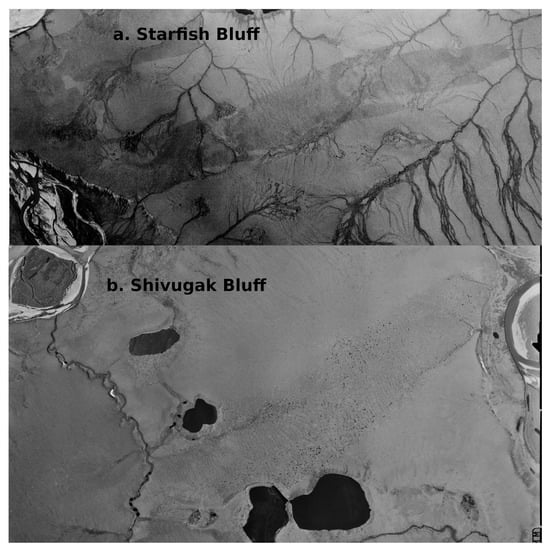
Figure 7.
Aerial photographs of prehistoric burns. (a) Starfish Bluff Burn (putative); USGS Entity ID: ARHM04908911505, Acquisition Date: 26 June 1955. (b) Shivugak Bluff Burn; USGS Entity ID: ARCBAR000540063, Acquisition Date: 18 July 1948. Both burns are visible in contemporary imagery.
A fourth prehistoric burn, Starfish Bluff, was found near the confluence of the Colville and Killik Rivers by C. Baughman. It is considered putative because it has not been visited on the ground as far as we are aware. It was found in a 1948 aerial image (Entity ID: ARCBAR000100187, Acquisition Date: 18 July 1948; Figure 7). Its shape, characteristics, and similarity to the Shivugak Bluff prehistoric burn as well as to other confirmed burns of more recent age lead us to strongly believe it is an old burn. The ratio of length to breadth of both these burns suggest that they were driven by strong winds.
4.4. Anecdotal Fires
4.4.1. Keys Project 1952
The earliest written record of a wildfire on the Arctic Slope that we are aware of is from 1952, associated with the the Keys Project in Northern Alaska. Tedrow [36] reported that “...an accidental brush fire located immediately north of Cache I burned four acres (1.6 ).” Their Cache I field camp was located “just north of Kurupa Lakes” up against the Brooks Range (Figure 1). No other information is available.
4.4.2. Spetzman 1959
A 1959 U.S. Geological Survey (USGS) Professional Paper by Spetzman [37] states: “Owing to the activities [related to oil exploration] and earth-moving machines, scattered areas near Umiat have been stripped of their natural vegetative cover or burned.” The PET-4 oil exploration project began in the Umiat area in 1944 [32,38,39,40].
4.4.3. Carbon Creek
We know of an ignition in the Carbon Creek drainage by the caption of Figure 12 in the 1991 report by Crory [35]: “Tundra fire only minutes after lightning strike in Carbon Creek area.” Carbon Creek is a watershed within the Utukok River drainage (Figure 1). The photograph in the figure was taken from an aircraft, and depicts a small column of smoke in the tundra. The ignition date and location of the fire are not provided, and there is no record of a fire in the Carbon Creek watershed, suggesting that this fire, as with many fires observed by pilots, was never reported. A search of a 1990 Landsat scene (LT05_AK_013002_19900810_20210423_02) shows a possible burn of 0.14 ha at 69.3523 × −159.7533, however, there is no prior scene or aerial photograph within four years to bracket the ignition date, nor are there any following scenes sufficiently cloud-free to confirm the burn before 1992.
Author Contributions
Conceptualization: E.A.M.; casual search: E.A.M., B.M.J., C.A.B., R.R.J. and D.A.Y.; Landsat systematic search: E.A.M.; AICC database maintenance and curation: J.L.J.; writing: E.A.M.; review and editing: all authors. All authors have read and agreed to the published version of the manuscript.
Funding
Support was provided to BMJ by National Science Foundation award OIA-1929170. This project received no other external funding.
Informed Consent Statement
Not applicable.
Data Availability Statement
The recorded and unrecorded fires presented here, as well as the lightning records, are available at https://fire.ak.blm.gov/predsvcs/maps.php (accessed on 22 January 2023). Landsat scenes and aerial photographs are available using the USGS Earth Explorer web application (https://earthexplorer.usgs.gov/ (accessed on 22 January 2023). MODIS and VIIRS thermal anomaly data are available at https://firms.modaps.eosdis.nasa.gov/download/ (accessed on 22 January 2023).
Acknowledgments
Support for this project was provided by the Alaska Fire Service of the Bureau of Land Management, the University of Alaska Fairbanks Institute of Northern Engineering, the Alaska Fire Science Consortium, and the U.S. Geological Survey, Alaska Science Center. We thank Kent Slaughter and Beth Ipsen (BLM, Alaska Fire Service) and Chris Noyles (BLM, Alaska State Office) for their support. Lisa Saperstein (U.S. Fish and Wildlife Service) provided a useful review and comments. The assistance of the Alaska Resources Library and Information Services (ARLIS) was indispensable during the literature search. We are grateful for the staff and facilities at Umiat (Bureau of Land Management) and Toolik Field Station (University of Alaska Fairbanks). RBM, ESM, and PFM assisted in naming the fires. We acknowledge the use of data and/or imagery from the National Aeronautics and Space Administration’s Land–Atmosphere Near-real-time Capability for EOS (LANCE) system (https://earthdata.nasa.gov/lance accessed on 1 March 2023) and Fire Information for Resource Management System (FIRMS) (https://earthdata.nasa.gov/firms accessed on 1 March 2023), both parts the Earth Observing System Data and Information System (EOSDIS). Any use of trade, firm, or product names is for descriptive purposes only and does not imply endorsement by the U.S. Government.
Conflicts of Interest
The authors declare no conflict of interest.
Appendix A. Attributes of Record-Worthy Burns
Table A1.
Attributes of record-worthy burns (continues in Table A2).
Table A1.
Attributes of record-worthy burns (continues in Table A2).
| Season | Name | Latitude | Longitude | Ignition Date | Area (ha) |
|---|---|---|---|---|---|
| 1972 | Ceratodon | 68.8080 | −154.1512 | 1971-07-23 to 1972-07-27 | 11 |
| 1977 | Inigok | 70.0011 | −153.0971 | 1977-07-11 to 1977-07-14 | 11 |
| 1984 | Salix | 68.8622 | −150.6955 | 1984-06-21 to 1984-06-30 | 3.4 |
| 1985 | Avens | 69.7895 | −158.0939 | 1985-06-20 to 1985-07-13 | 88 |
| 1985 | Cladina | 69.8585 | −157.9752 | 1985-06-20 to 1985-07-13 | 44 |
| 1985 | Titaluk | 69.5673 | −155.2610 | 1985-08-09 | 173 |
| 1985 | Vaccinium | 69.7803 | −158.2412 | 1985-06-20 to 1985-07-13 | 92 |
| 1986 | Betula | 68.8203 | −150.8873 | 1986-06-18 to 1986-06-27 | 20 |
| 2003 | Cassiope | 69.4895 | −154.7580 | 2003-06-25 to 2003-07-18 | 44 |
| 2003 | Heather | 69.4992 | −154.7064 | 2003-06-25 to 2003-07-18 | 100 |
| 2003 | Pedicularis | 69.5036 | −153.6430 | 2003-06-25 | 8 |
| 2003 | Peltigera | 68.7301 | −151.4612 | 2003-07-10 | 1 |
| 2004 | Pohlia | 68.7510 | −155.4847 | 2004-06-09 to 2004-06-18 | 53 |
| 2008 | Cladonia | 69.1227 | −153.9116 | 2008-06-13 to 2008-06-29 | 4.6 |
| 2008 | Kogosukruk | 69.6676 | −151.6790 | 2008-06-29 to 2008-07-24 | 23.5 |
| 2009 | Aulacomnium | 68.7014 | −150.5654 | 2009-06-09 to 2009-07-04 | 5.6 |
| 2009 | Mammoth | 68.8378 | −152.6011 | 2009-06-17 | 25 |
| 2009 | Nana | 68.8225 | −151.0448 | 2009-06-09 to 2009-07-04 | 2 |
| 2009 | Sage | 68.9120 | −154.1738 | 2009-07-02 to 2009-07-17 | 0.6 |
| 2010 | Butterfly | 69.2124 | −153.5482 | 2010-06-09 | 2 |
| 2010 | Cottongrass | 69.2176 | −155.3051 | 2010-06-06 to 2010-06-10 | 3.8 |
| 2010 | Cottontail | 68.4748 | −151.7633 | 2010-06-09 | 3 |
| 2010 | Dryas | 69.3390 | −153.3641 | 2010-06-09 | 7 |
| 2010 | Empetrum | 69.2337 | −152.4152 | 2010-06-09 | 34 |
| 2010 | Eriophorum | 68.7674 | −150.6744 | 2010-06-05 to 2010-06-14 | 2 |
| 2010 | Flavocetraria | 68.6730 | −151.9824 | 2010-06-09 | 2.9 |
| 2010 | Gulo | 69.1308 | −155.1082 | 2010-06-08 | 1.2 |
| 2010 | Hylocomium | 69.4549 | −153.2793 | 2010-06-09 | 1 |
| 2010 | Lepidozia | 68.8002 | −153.0847 | 2010-06-05 to 2010-06-12 | 4.5 |
| 2010 | Nanushek | 68.8667 | −150.6138 | 2010-06-08 | 1.1 |
| 2010 | Nephroma | 68.6658 | −151.9261 | 2010-06-09 | 7.2 |
| 2010 | Peltigera | 68.6653 | −151.9007 | 2010-06-09 | 36 |
| 2010 | Planifolia | 68.8359 | −151.0610 | 2010-06-08 | 1 |
| 2010 | Pleurozium | 69.4709 | −153.2779 | 2010-06-09 | 0.5 |
| 2010 | Pulchra | 68.8249 | −150.9608 | 2010-06-08 | 1 |
| 2010 | Rhododendron | 69.3093 | −153.3296 | 2010-06-09 | 7 |
| 2010 | Thamnolia | 68.6658 | −151.8589 | 2010-06-09 | 29 |
| 2010 | Tussock | 68.7807 | −150.2816 | 2010-06-08 | 0.04 |
| 2011 | Horsetail | 68.8780 | −150.6790 | 2011-07-19 to 2011-08-04 | 2 |
| 2013 | Avalik River | 69.9536 | −158.1701 | 2013-06-20 | 56 |
| 2013 | Henry | 69.4736 | −152.1140 | 2013-06-20 | 6.8 |
| 2013 | Kogosukruk | 69.4644 | −152.2333 | 2013-06-20 | 8 |
| 2013 | Omicron Hill | 69.8964 | −158.1434 | 2013-06-21 | 70 |
| 2013 | Paneak | 69.3859 | −159.5306 | 2013-06-20 | 36 |
| 2013 | Shirukak | 69.6510 | −150.7891 | 2013-06-14 | 31 |
| 2013 | Shivugak | 69.4209 | −151.9021 | 2013-06-20 | 8 |
| 2013 | Siksik | 68.7175 | −153.0638 | 2013-06-21 | 25 |
| 2013 | Tarandus | 70.0150 | −158.0744 | 2013-06-20 | 27 |
| 2013 | Vulpes | 68.7875 | −154.5913 | 2013-06-21 | 2.1 |
| 2016 | Aurora | 69.4769 | −150.5602 | 2016-07-08 to 2016-07-13 | 2 |
| 2016 | Horsetail | 68.8776 | −153.1973 | 2016-06-11 to 2016-06-27 | 4.8 |
| 2016 | Point Lay | 69.7214 | −162.9201 | 2016-08-06 to 2016-08-17 | 3.8 |
| 2017 | Arnica | 68.7862 | −150.7068 | 2017-07-18 to 2017-08-10 | 11.6 |
| 2018 | Ipewik | 68.5580 | −164.4517 | 2018-06-28 to 2018-07-03 | 279 |
| 2020 | Thamnolia | 68.8224 | −161.0614 | 2020-06-03 to 2020-06-08 | 142 |
| 2022 | Dicranum | 68.6591 | −151.7611 | 2022-07-09 | 1.1 |
| 2022 | Drepanocladus | 68.6831 | −153.2635 | 2022-06-14 to 2022-06-19 | 6 |
| 2022 | Marchantia | 69.8569 | −148.5772 | 2022-08-10 to 2022-08-24 | 67 |
| 2022 | Petasites | 68.9090 | −153.9631 | 2021-09-12 to 2022-08-04 | 25 |
| 2022 | Sphagnum | 68.7280 | −153.2906 | 2022-07-08 to 2022-07-16 | 17 |
Table A2.
Attributes of record-worthy burns (continued from Table A1); indicates aerial photograph.
Table A2.
Attributes of record-worthy burns (continued from Table A1); indicates aerial photograph.
| Season | Name | Representative Scene |
|---|---|---|
| 1972 | Ceratodon | LM01_L1TP_083011_19720727_20200909_02_T1 |
| 1977 | Inigok | LM01_L1TP_083011_19770714_20201008_02_T1 |
| 1984 | Salix | LM04_L1TP_075011_19840722_20200902_02_T2 |
| 1985 | Avens | LM05_L1TP_079011_19850713_20200901_02_T2 |
| 1985 | Cladina | LM05_L1TP_079011_19850713_20200901_02_T2 |
| 1985 | Titaluk | AR5850034801245 |
| 1985 | Vaccinium | LM05_L1TP_079011_19850713_20200901_02_T2 |
| 1986 | Betula | LT05_L1TP_075011_19860704_20200918_02_T1 |
| 2003 | Cassiope | LE07_AK_014002_20030718_20210428_02 |
| 2003 | Heather | LE07_AK_014002_20030718_20210428_02 |
| 2003 | Pedicularis | LE07_AK_014002_20030718_20210428_02 |
| 2003 | Peltigera | LE07_AK_015002_20030720_20210428_02 |
| 2004 | Pohlia | LE07_L2SP_076012_20040618_20200915_02_T1 |
| 2008 | Cladonia | LE07_L1TP_076011_20080629_20200912_02_T1 |
| 2008 | Kogosukruk | LE07_L1TP_075011_20080724_20200912_02_T1 |
| 2009 | Aulacomnium | LE07_L1TP_074012_20090704_20200911_02_T1 |
| 2009 | Mammoth | LE07_AK_015002_20090702_20210430_02 |
| 2009 | Nana | LE07_L1TP_074012_20090704_20200911_02_T1 |
| 2009 | Sage | LT05_AK_014002_20090717_20210430_02 |
| 2010 | Butterfly | LE07_AK_014002_20100612_20210430_02 |
| 2010 | Cottongrass | LE07_AK_014002_20100617_20210430_02_DSWE |
| 2010 | Cottontail | LE07_AK_015002_20100630_20210430_02 |
| 2010 | Dryas | LT05_L1TP_075011_20100620_20160901_01_T1 |
| 2010 | Empetrum | LT05_L1TP_075011_20100620_20160901_01_T1 |
| 2010 | Eriophorum | LE07_L1TP_073012_20100614_20200911_02_T1 |
| 2010 | Flavocetraria | LT05_L1TP_075012_20100620_20200824_02_T1 |
| 2010 | Gulo | LE07_AK_014002_20100610_20210430_02 |
| 2010 | Hylocomium | LT05_L1TP_075011_20100620_20160901_01_T1 |
| 2010 | Lepidozia | LE07_L1TP_075012_20100612_20200911_02_T1 |
| 2010 | Nanushek | LT05_L2SP_075011_20100620_20200823_02_T1 |
| 2010 | Nephroma | LT05_L1TP_075012_20100620_20200824_02_T1 |
| 2010 | Peltigera | LT05_L1TP_075012_20100620_20200824_02_T1 |
| 2010 | Planifolia | LT05_L2SP_075011_20100620_20200823_02_T1 |
| 2010 | Pleurozium | LT05_L1TP_075011_20100620_20160901_01_T1 |
| 2010 | Pulchra | LT05_L2SP_075011_20100620_20200823_02_T1 |
| 2010 | Rhododendron | LT05_L1TP_075011_20100620_20160901_01_T1 |
| 2010 | Thamnolia | LT05_L1TP_075012_20100620_20200824_02_T1 |
| 2010 | Tussock | LT05_AK_015002_20100620_20210430_02 |
| 2011 | Horsetail | LE07_L2SP_074011_20110912_20200910_02_T1 |
| 2013 | Avalik River | LC08_AK_013001_20130701_20210501_02 |
| 2013 | Henry | LC08_AK_015002_20130621_20210501_02 |
| 2013 | Kogosukruk | LC08_AK_015002_20130621_20210501_02 |
| 2013 | Omicron Hill | LC08_AK_013001_20130701_20210501_02 |
| 2013 | Paneak | LE07_AK_013002_20130725_20210501_02 |
| 2013 | Shirukak | LC08_L2SP_076011_20130619_20200912_02_T1 |
| 2013 | Shivugak | LC08_AK_015002_20130621_20210501_02 |
| 2013 | Siksik | LC08_AK_014002_20130621_20210501_02 |
| 2013 | Tarandus | LC08_AK_013001_20130701_20210501_02 |
| 2013 | Vulpes | LC08_AK_014002_20130626_20210501_02 |
| 2016 | Aurora | LC08_AK_015002_20160713_20210502_02 |
| 2016 | Horsetail | LC08_AK_014002_20160627_20210502_02 |
| 2016 | Point Lay | LC08_AK_012001_20160817_20210502_02 |
| 2017 | Arnica | LC08_L1TP_075012_20170810_20200903_02_T1 |
| 2018 | Ipewik | LE07_AK_011002_20180703_20210503_02 |
| 2020 | Thamnolia | LE07_AK_012002_20200608_20210504_02 |
| 2022 | Dicranum | LC08_AK_015002_20220709_20220725_02 |
| 2022 | Drepanocladus | LC09_AK_014002_20220620_20220625_02 |
| 2022 | Marchantia | LC08_L1TP_075011_20220824_20220924_02_T1 |
| 2022 | Petasites | LE07_L2SP_075012_20220804_20220902_02_T1 |
| 2022 | Sphagnum | LC08_AK_014002_20220716_20220729_02 |
References
- Descals, A.; Gaveau, D.L.A.; Verger, A.; Sheil, D.; Naito, D.; Peñuelas, J. Unprecedented fire activity above the Arctic Circle linked to rising temperatures. Science 2022, 378, 532–537. [Google Scholar] [CrossRef] [PubMed]
- Rantanen, M.; Karpechko, A.Y.; Lipponen, A.; Nordling, K.; Hyvärinen, O.; Ruosteenoja, K.; Vihma, T.; Laaksonen, A. The Arctic has warmed nearly four times faster than the globe since 1979. Commun. Earth Environ. 2022, 3, 168. [Google Scholar] [CrossRef]
- Barney, R.J.; Comiskey, A.L. Wildfires and Thunderstorms on Alaska’s North Slopes; Technical Report, Research Note PNW-212; U.S. Forest Service, Pacific Northwest Forest and Range Experiment Station: Portland, OR, USA, 1973.
- Wein, R. Frequency and Characteristics of Arctic Tundra Fires. Arctic 1976, 29, 213–222. [Google Scholar] [CrossRef]
- Hu, F.S.; Higuera, P.E.; Walsh, J.E.; Chapman, W.L.; Duffy, P.A.; Brubaker, L.B.; Chipman, M.L. Tundra burning in Alaska: Linkages to climatic change and sea ice retreat. J. Geophys. Res. Biogeosci. 2010, 115. [Google Scholar] [CrossRef]
- Chipman, M.L.; Hudspith, V.; Higuera, P.E.; Duffy, P.A.; Kelly, R.; Oswald, W.W.; Hu, F.S. Spatiotemporal patterns of tundra fires: Late-Quaternary charcoal records from Alaska. Biogeosciences 2015, 12, 4017–4027. [Google Scholar] [CrossRef]
- Jones, B.M.; Breen, A.L.; Gaglioti, B.V.; Mann, D.H.; Rocha, A.V.; Grosse, G.; Arp, C.D.; Kunz, M.L.; Walker, D.A. Identification of unrecognized tundra fire events on the north slope of Alaska. J. Geophys. Res. Biogeosci. 2013, 118, 1334–1344. [Google Scholar] [CrossRef]
- Todd, S.K.; Jewkes, H.A. Wildland Fire in Alaska: A History of Organized Fire Suppression and Management in the Last Frontier; Technical Report, Bulletin No. 114; Agricultural and Forestry Experiment Station University of Alaska Fairbanks: Fairbanks, AK, USA, 2006. [Google Scholar]
- Rocha, A.V.; Loranty, M.M.; Higuera, P.E.; Mack, M.C.; Hu, F.S.; Jones, B.M.; Breen, A.L.; Rastetter, E.B.; Goetz, S.J.; Shaver, G.R. The footprint of Alaskan tundra fires during the past half-century: Implications for surface properties and radiative forcing. Environ. Res. Lett. 2012, 7, 044039. [Google Scholar] [CrossRef]
- French, N.H.F.; Jenkins, L.K.; Loboda, T.V.; Flannigan, M.; Jandt, R.; Bourgeau-Chavez, L.L.; Whitley, M. Fire in arctic tundra of Alaska: Past fire activity, future fire potential, and significance for land management and ecology. Int. J. Wildland Fire 2015, 24, 1045–1061. [Google Scholar] [CrossRef]
- Hu, F.S.; Higuera, P.E.; Duffy, P.; Chipman, M.L.; Rocha, A.V.; Young, A.M.; Kelly, R.; Dietze, M.C. Arctic tundra fires: Natural variability and responses to climate change. Front. Ecol. Environ. 2015, 13, 369–377. [Google Scholar] [CrossRef]
- Young, A.M.; Higuera, P.E.; Duffy, P.A.; Hu, F.S. Climatic thresholds shape northern high-latitude fire regimes and imply vulnerability to future climate change. Ecography 2017, 40, 606–617. [Google Scholar] [CrossRef]
- Masrur, A.; Petrov, A.N.; DeGroote, J. Circumpolar spatio-temporal patterns and contributing climatic factors of wildfire activity in the Arctic tundra from 2001–2015. Environ. Res. Lett. 2018, 13, 014019. [Google Scholar] [CrossRef]
- Masrur, A.; Taylor, A.; Harris, L.; Barnes, J.; Petrov, A. Topography, Climate and Fire History Regulate Wildfire Activity in the Alaskan Tundra. J. Geophys. Res. Biogeosci. 2022, 127, e2021JG006608. [Google Scholar] [CrossRef]
- Jones, B.M.; Grosse, G.; Arp, C.D.; Miller, E.; Liu, L.; Hayes, D.J.; Larsen, C.F. Recent Arctic tundra fire initiates widespread thermokarst development. Sci. Rep. 2015, 5, 15865. [Google Scholar] [CrossRef]
- Jandt, R.R.; Miller, E.A.; Jones, B.M. Fire Effects 10 Years after the Anaktuvuk River Tundra Fires; BLM Alaska Technical Report #64; Bureau of Land Management Alaska: Anchorage, AK, USA, 2021.
- Gaglioti, B.V.; Berner, L.T.; Jones, B.M.; Orndahl, K.M.; Williams, A.P.; Andreu-Hayles, L.; D’Arrigo, R.D.; Goetz, S.J.; Mann, D.H. Tussocks Enduring or Shrubs Greening: Alternate Responses to Changing Fire Regimes in the Noatak River Valley, Alaska. J. Geophys. Res. Biogeosci. 2021, 126, e2020JG006009. [Google Scholar] [CrossRef]
- Muller, S.; Walker, D.A.; Jorgenson, M.T. Land Cover and Ecosystem Map Collection for Northern Alaska; Oak Ridge National Laboratory Distributed Active Archive Center: Oak Ridge, TN, USA, 2018. [CrossRef]
- Landsat Program. United States Geological Survey and National Aeronautics and Space Administration. Available online: https://www.usgs.gov/landsat-missions (accessed on 22 January 2023).
- Hawbaker, T.J.; Vanderhoof, M.K.; Schmidt, G.L.; Beal, Y.J.; Picotte, J.J.; Takacs, J.D.; Falgout, J.T.; Dwyer, J.L. The Landsat Burned Area algorithm and products for the conterminous United States. Remote Sens. Environ. 2020, 244, 111801. [Google Scholar] [CrossRef]
- Goward, S.; Arvidson, T.; Williams, D.; Faundeen, J.; Irons, J.; Franks, S. Historical record of Landsat global coverage: Mission operations, NSLRSDA, and international cooperator stations. Photogramm. Eng. Remote Sens. 2006, 72, 1155–1169. [Google Scholar] [CrossRef]
- Hall, D.; Brown, J.; Johnson, L. The 1977 Tundra Fire at Kokolik River, Alaska; Technical Report, Special Report 78-10; U.S. Army Corps of Engineers, Cold Regions Research and Engineering Laboratory: Hanover, NH, USA, 1978. [Google Scholar]
- Hall, D.K.; Brown, J.; Johnson, L. The 1977 tundra fire in the Kokolik River area of Alaska. Arctic 1978, 31, 54–58. [Google Scholar] [CrossRef]
- Loboda, T.; Hall, J.; Baer, A. ABoVE: Wildfire Date of Burning within Fire Scars across Alaska and Canada, 2001–2019; ORNL DAAC: Oak Ridge, TN, USA, 2021. [CrossRef]
- Chen, D.; Shevade, V.; Baer, A.; Loboda, T.V. Missing Burns in the High Northern Latitudes: The Case for Regionally Focused Burned Area Products. Remote Sens. 2021, 13, 4145. [Google Scholar] [CrossRef]
- Liu, L.; Jafarov, E.E.; Schaefer, K.M.; Jones, B.M.; Zebker, H.A.; Williams, C.A.; Rogan, J.; Zhang, T. InSAR detects increase in surface subsidence caused by an Arctic tundra fire. Geophys. Res. Lett. 2014, 41, 3906–3913. [Google Scholar] [CrossRef]
- Iwahana, G.; Uchida, M.; Liu, L.; Gong, W.; Meyer, F.J.; Guritz, R.; Yamanokuchi, T.; Hinzman, L. InSAR Detection and Field Evidence for Thermokarst after a Tundra Wildfire, Using ALOS-PALSAR. Remote Sens. 2016, 8, 218. [Google Scholar] [CrossRef]
- Liljedahl, A.K.; Boike, J.; Daanen, R.P.; Fedorov, A.N.; Frost, G.V.; Grosse, G.; Hinzman, L.D.; Iijma, Y.; Jorgenson, J.C.; Matveyeva, N.; et al. Pan-Arctic ice-wedge degradation in warming permafrost and its influence on tundra hydrology. Nat. Geosci. 2016, 9, 312. [Google Scholar] [CrossRef]
- Chen, Y.; Lara, M.J.; Jones, B.M.; Frost, G.V.; Hu, F.S. Thermokarst acceleration in arctic tundra driven by climate change and fire disturbance. ONE Earth 2021, 4, 1718–1729. [Google Scholar] [CrossRef]
- Chen, Y.; Hu, F.S.; Lara, M.J. Divergent shrub-cover responses driven by climate, wildfire, and permafrost interactions in Arctic tundra ecosystems. Glob. Chang. Biol. 2021, 27, 652–663. [Google Scholar] [CrossRef] [PubMed]
- Hollingsworth, T.N.; Breen, A.L.; Hewitt, R.E.; Mack, M.C. Does fire always accelerate shrub expansion in Arctic tundra? Examining a novel grass-dominated successional trajectory on the Seward Peninsula. Arctic, Antarct. Alp. Res. 2021, 53, 93–109. [Google Scholar] [CrossRef]
- Gryc, G. Geology and Exploration of the National Petroleum Reserve in Alaska, 1974 to 1982; Report 1399; United States Geological Survey: Washington, DC, USA, 1988.
- McBride, F.E. Alaska Fire Season—1977. Fire Manag. Notes 1978, 39, 3–7. [Google Scholar]
- Racine, C.H.; Dennis, J.G.; Patterson, W.A. Tundra fire regimes in the Noatak River Watershed, Alaska: 1956-83. Arctic 1985, 38, 194–200. [Google Scholar] [CrossRef]
- Crory, F.E. Construction Guidelines for Oil and Gas Exploration in Northern Alaska; Technical Report, Report 91-21; U.S. Army Corps of Engineers, Cold Regions Research and Engineering Laboratory: Hanover, NH, USA, 1991. [Google Scholar]
- Tedrow, J.C.F. The Keys Project in Northern Alaska, 1951-53. Arctic 2005, 58, 421–424. [Google Scholar] [CrossRef]
- Spetzman, L.A. Vegetation of the Arctic Slope of Alaska; Technical Report, U.S. Geological Survey Professional Paper 302-B; U.S. Geological Survey: Washington, DC, USA, 1959.
- Robinson, F.M. Test Wells, Gubik Area, Alaska; Technical Report, U.S. Geological Survey Professional Paper 305-C; U.S. Geological Survey: Washington, DC, USA, 1958.
- Reed, J.C. Exploration of Naval Petroleum Reserve No. 4 and Adjacent Areas Northern Alaska, 1944-53. Part 1, History of the Exploration; Professional Paper 301; U.S. Geological Survey: Washington, DC, USA, 1958.
- Gryc, G. The National Petroleum Reserve in Alaska Earth Science Considerations; Report 1240-C; United States Geological Survey: Washington, DC, USA, 1985.
Disclaimer/Publisher’s Note: The statements, opinions and data contained in all publications are solely those of the individual author(s) and contributor(s) and not of MDPI and/or the editor(s). MDPI and/or the editor(s) disclaim responsibility for any injury to people or property resulting from any ideas, methods, instructions or products referred to in the content. |
© 2023 by the authors. Licensee MDPI, Basel, Switzerland. This article is an open access article distributed under the terms and conditions of the Creative Commons Attribution (CC BY) license (https://creativecommons.org/licenses/by/4.0/).