Surface Mechanical Effects of Wildfires on Rocks in Climbing Areas

 ,
,  ,
, 
 ,
,
Abstract
1. Introduction
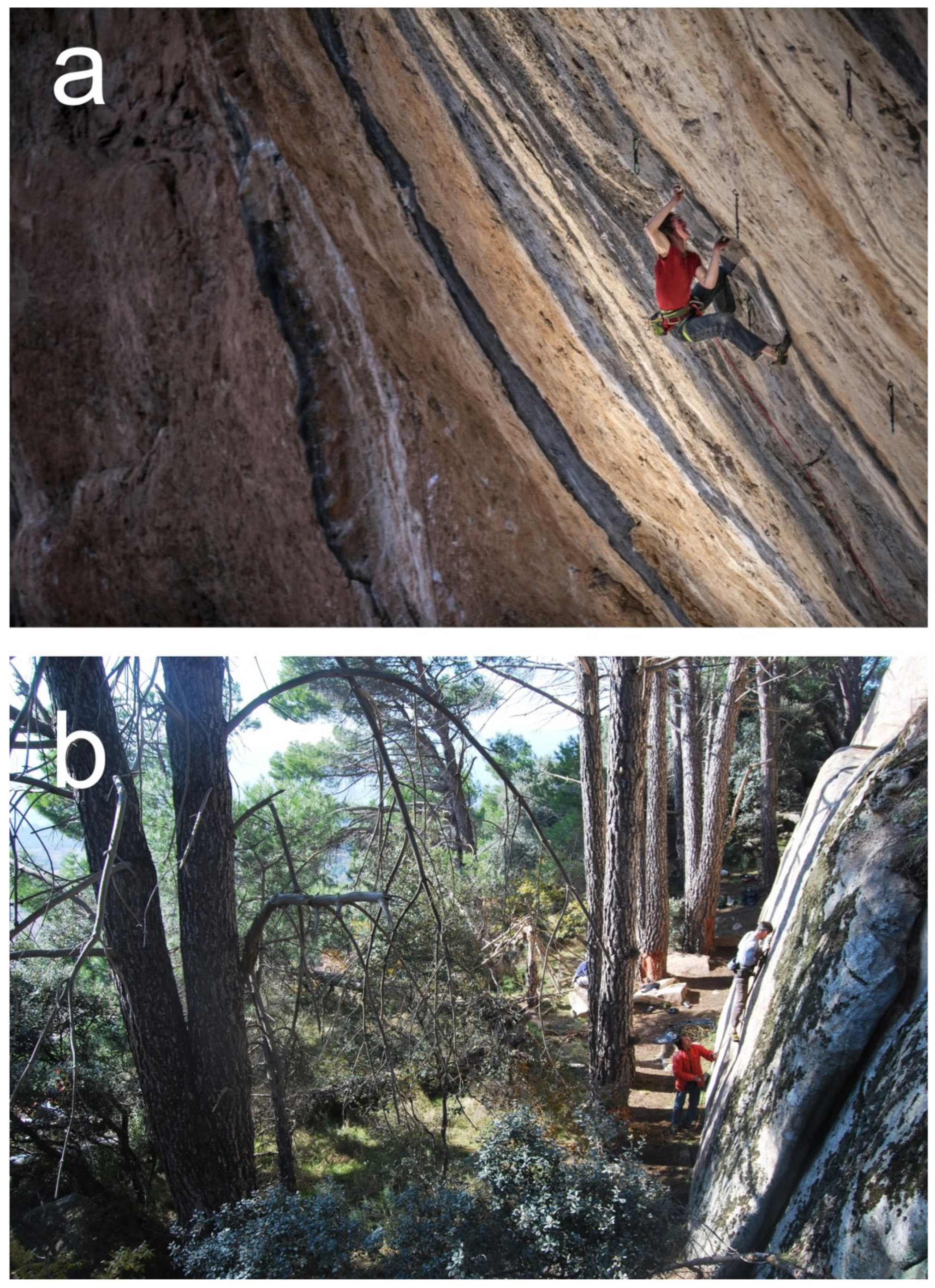
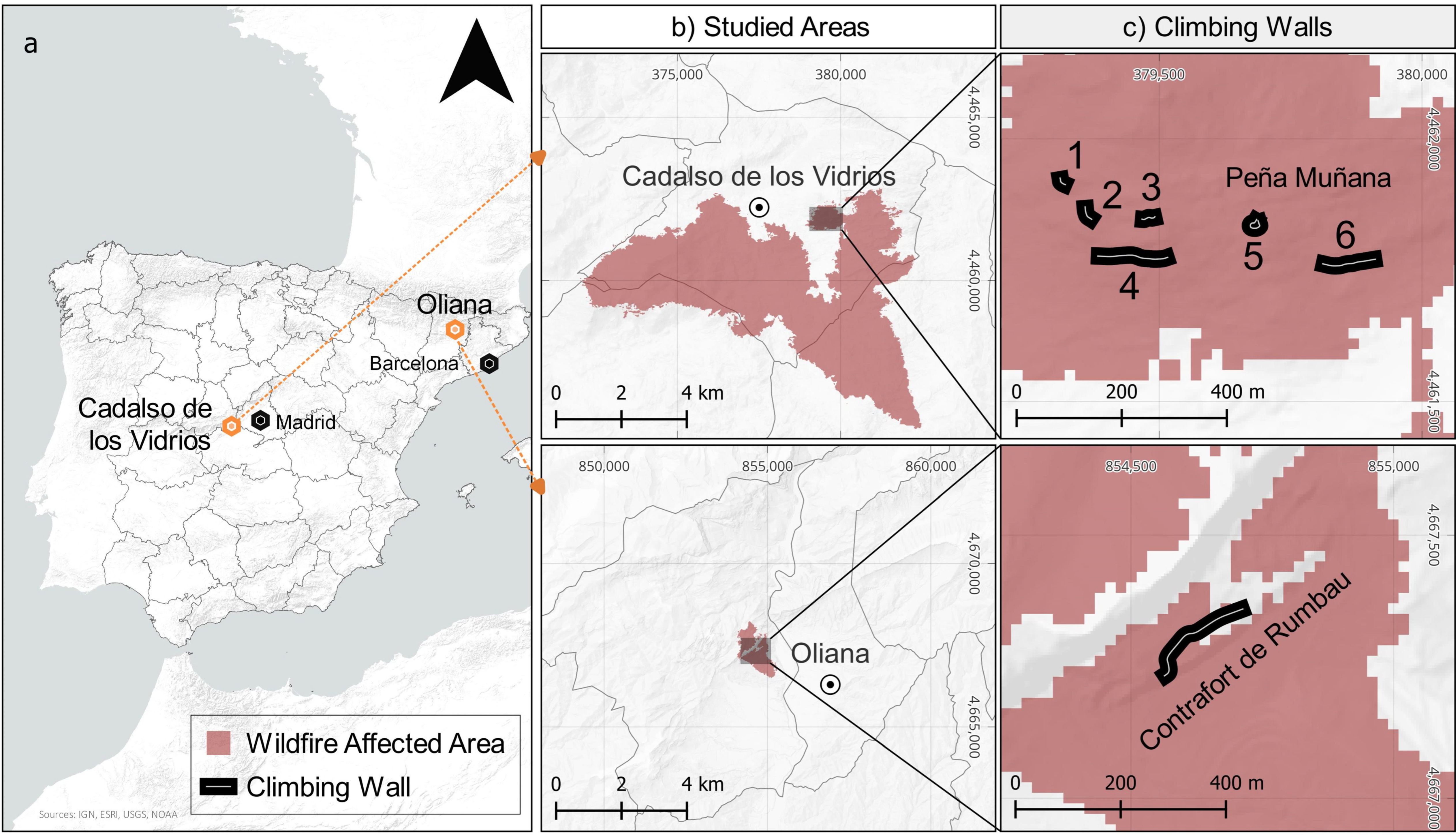
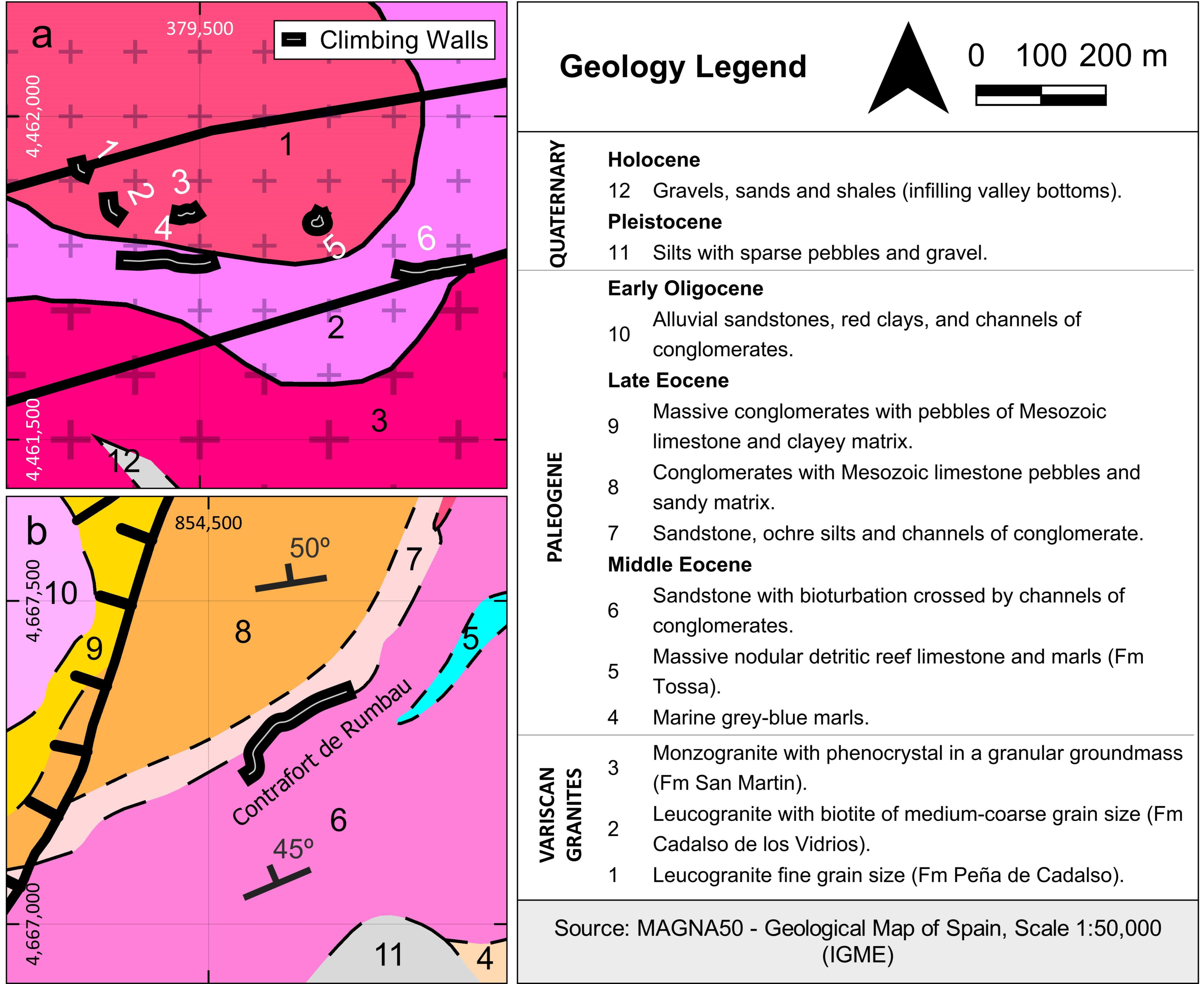
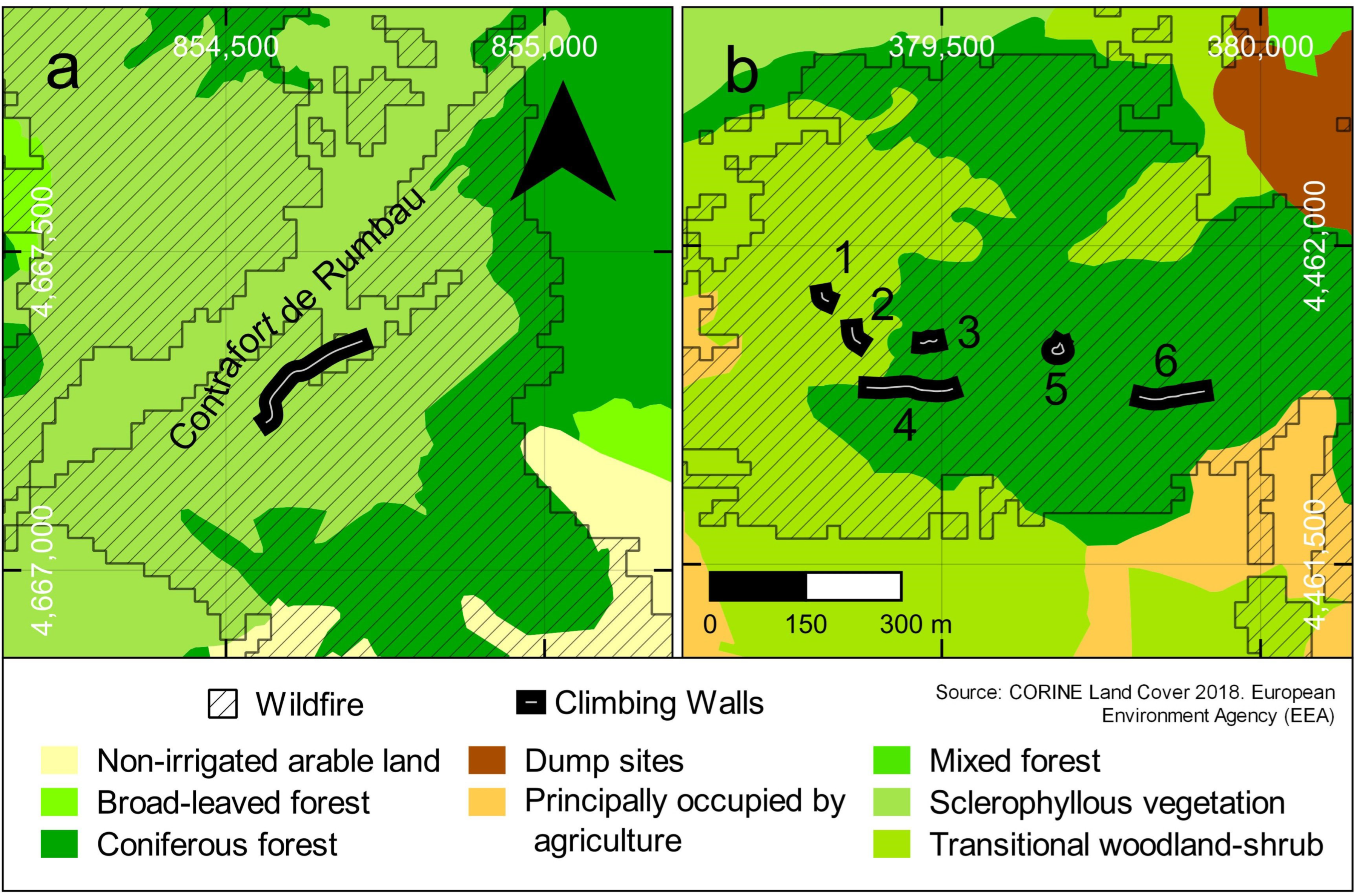
2. Study Areas
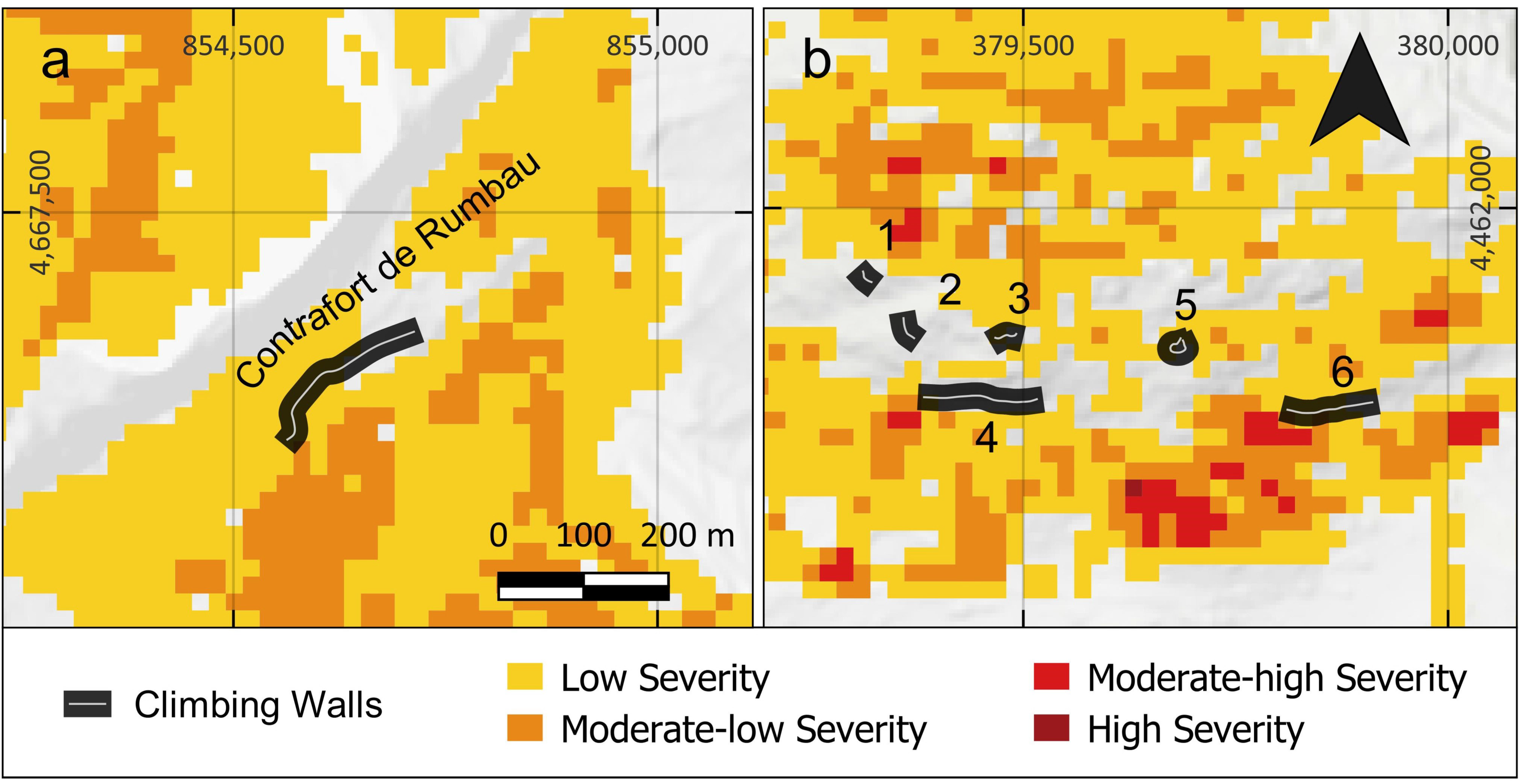
2.1. Oliana Climbing Site
2.2. Cadalso de los Vidrios Climbing Site
3. Wildfires at the Study Areas
4. Materials and Methods
5. Results
5.1. Mechanical Effects of Wildfires on Climbing Areas
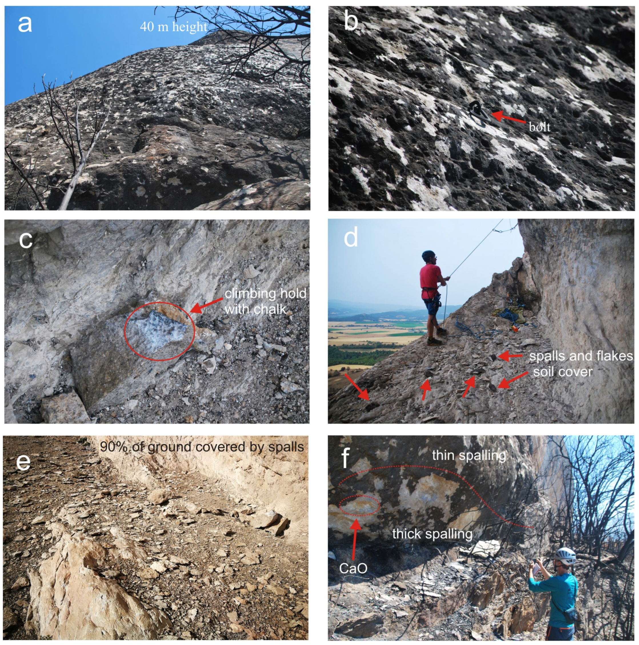
5.1.1. Surface Changes in Bedrock Outcrops Affecting Climbing Routes
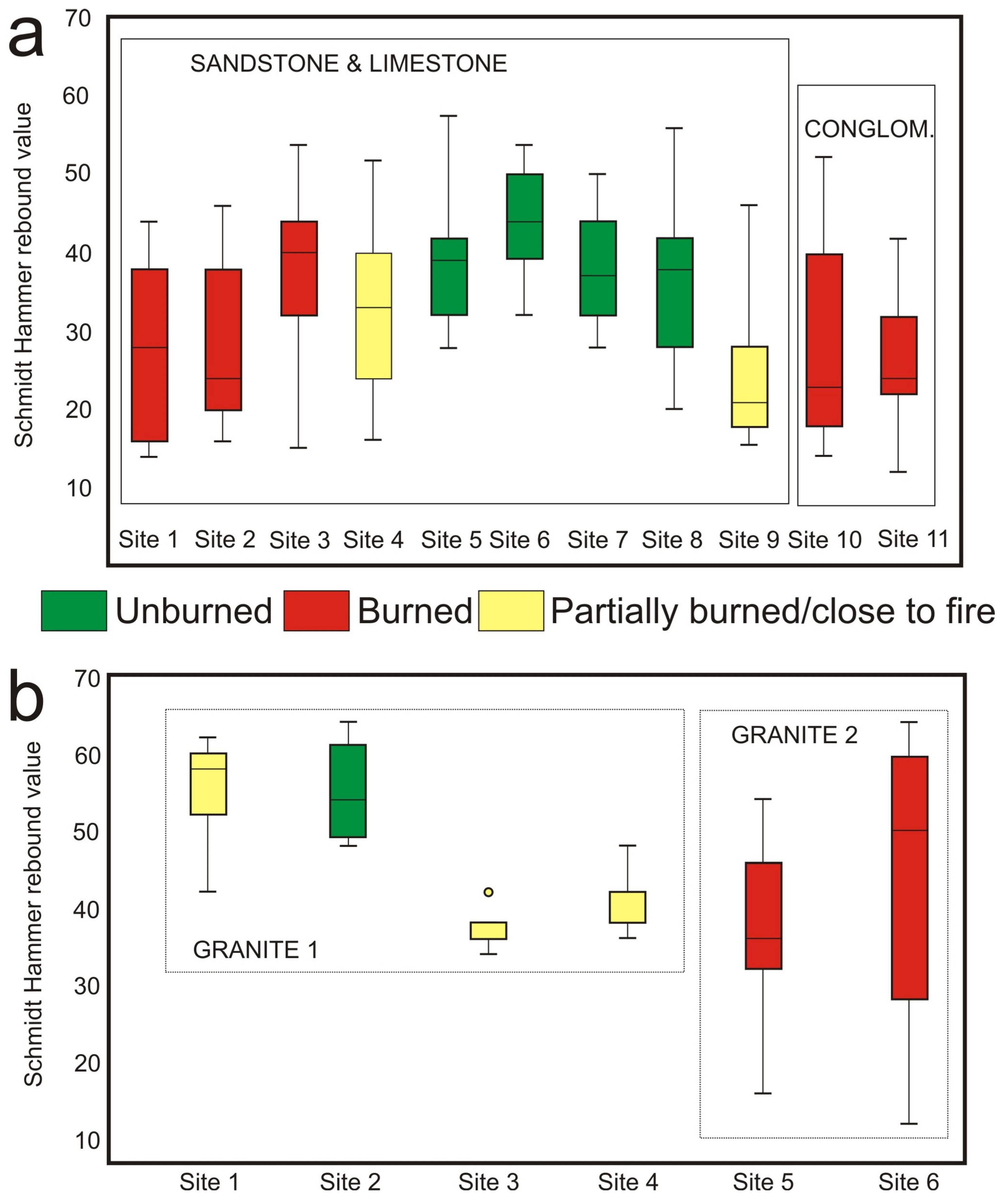
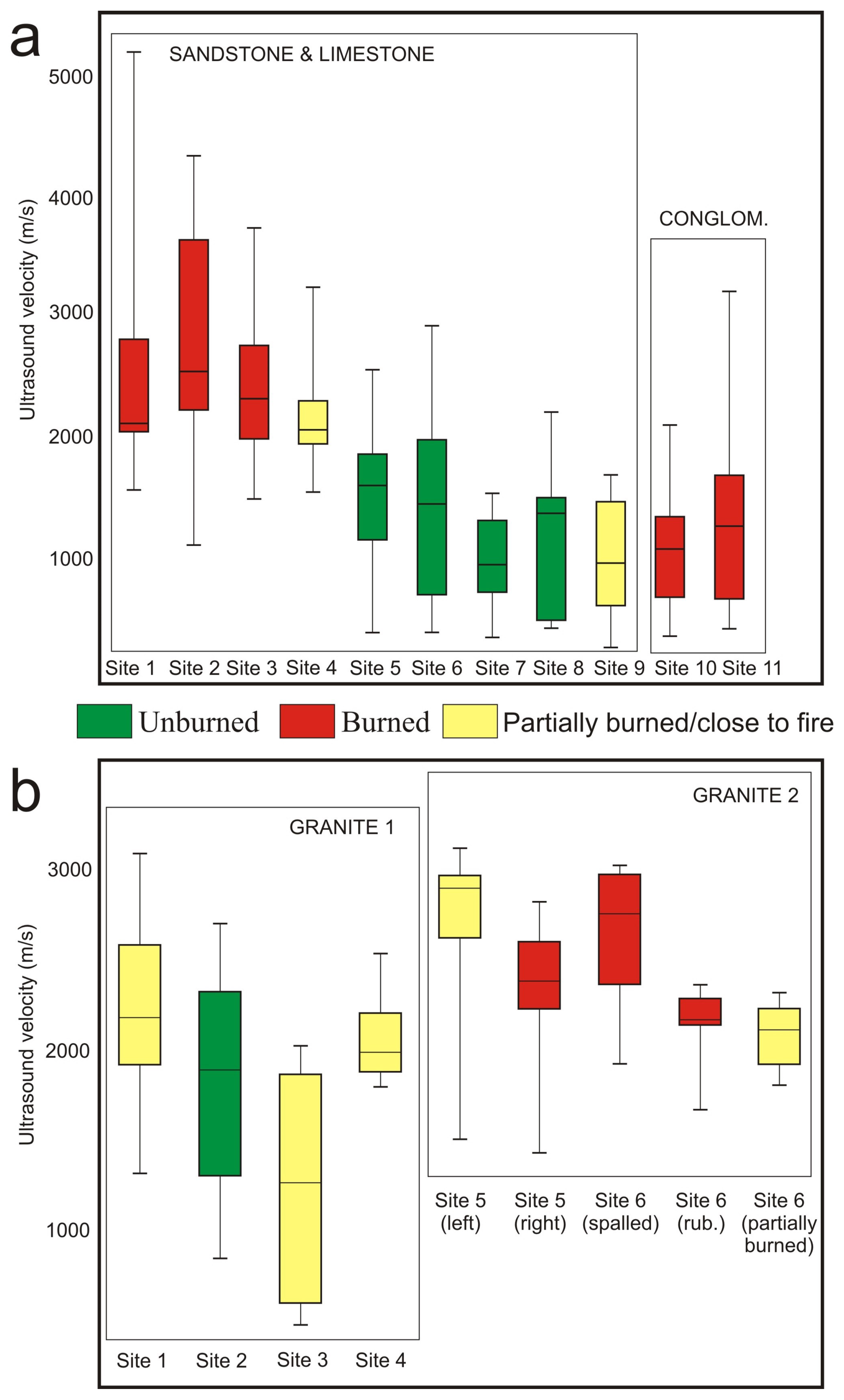
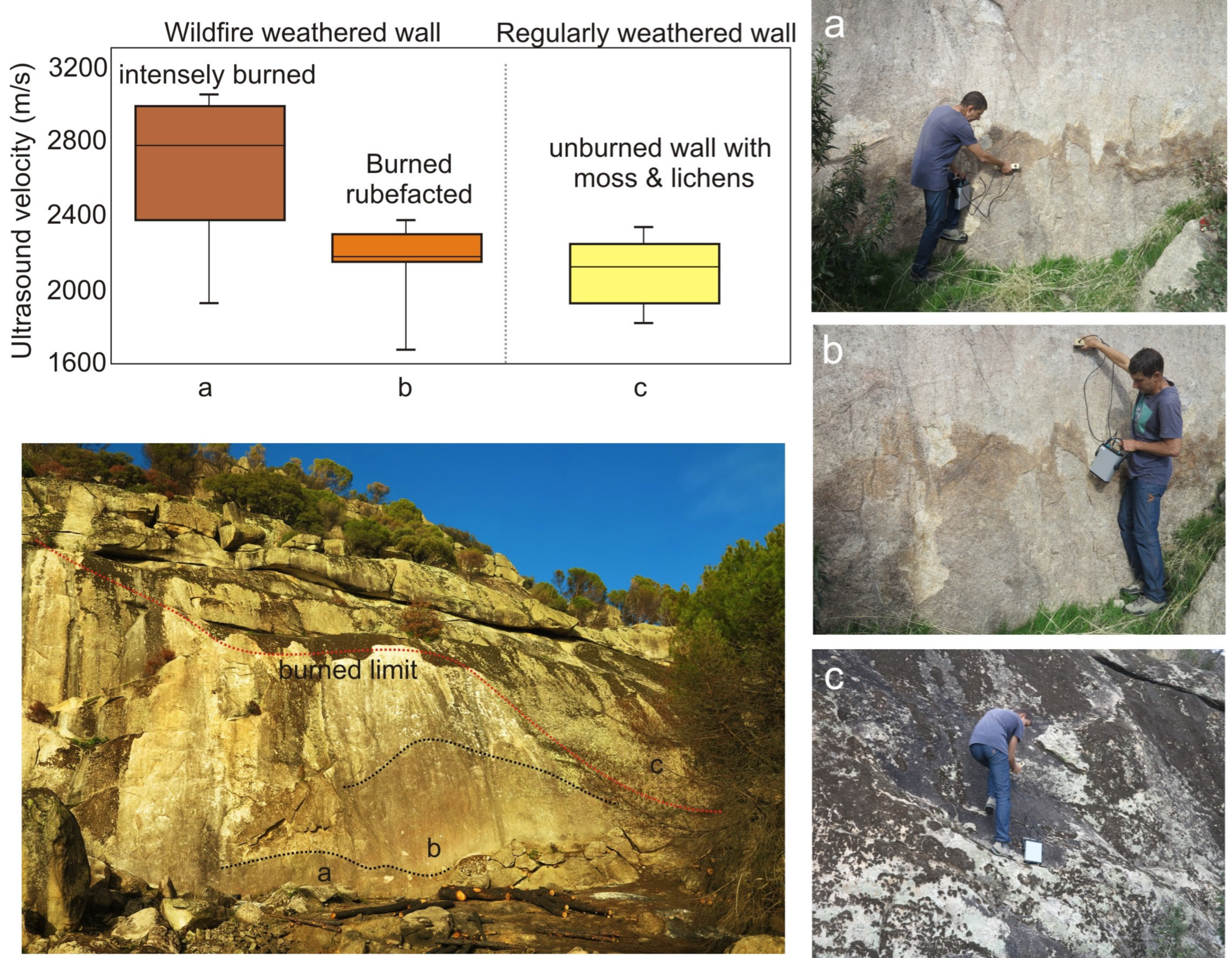
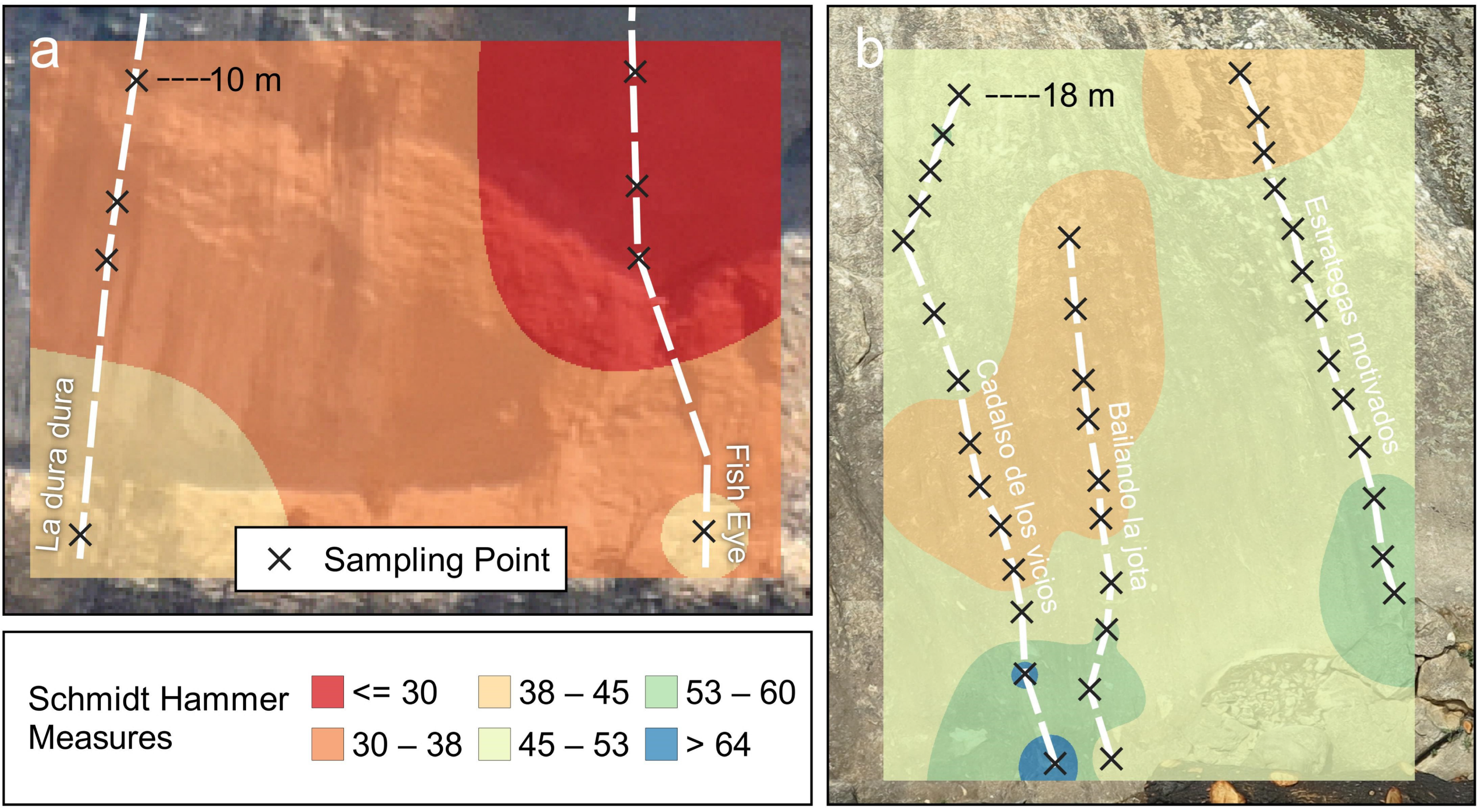
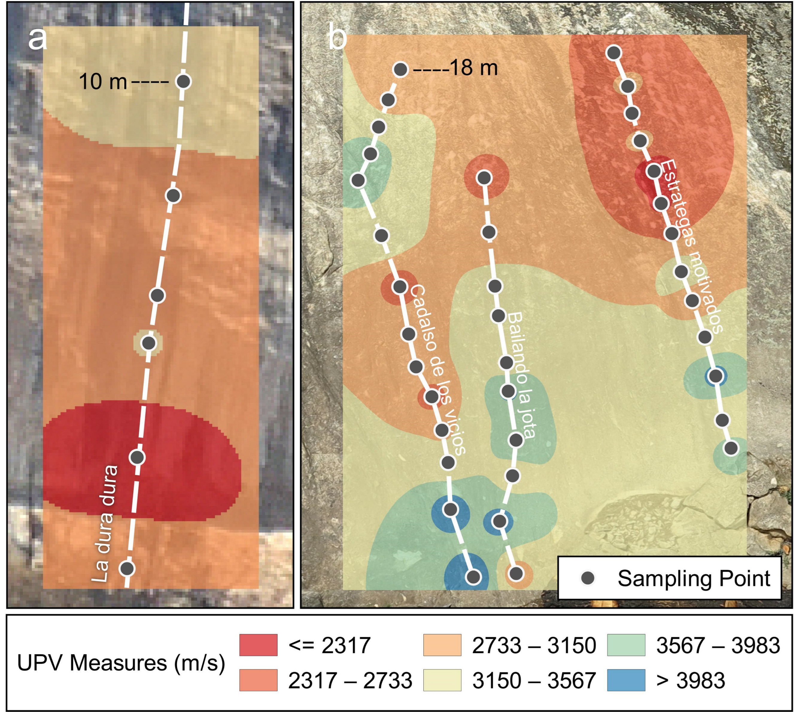
5.1.2. Non-Destructive Testing
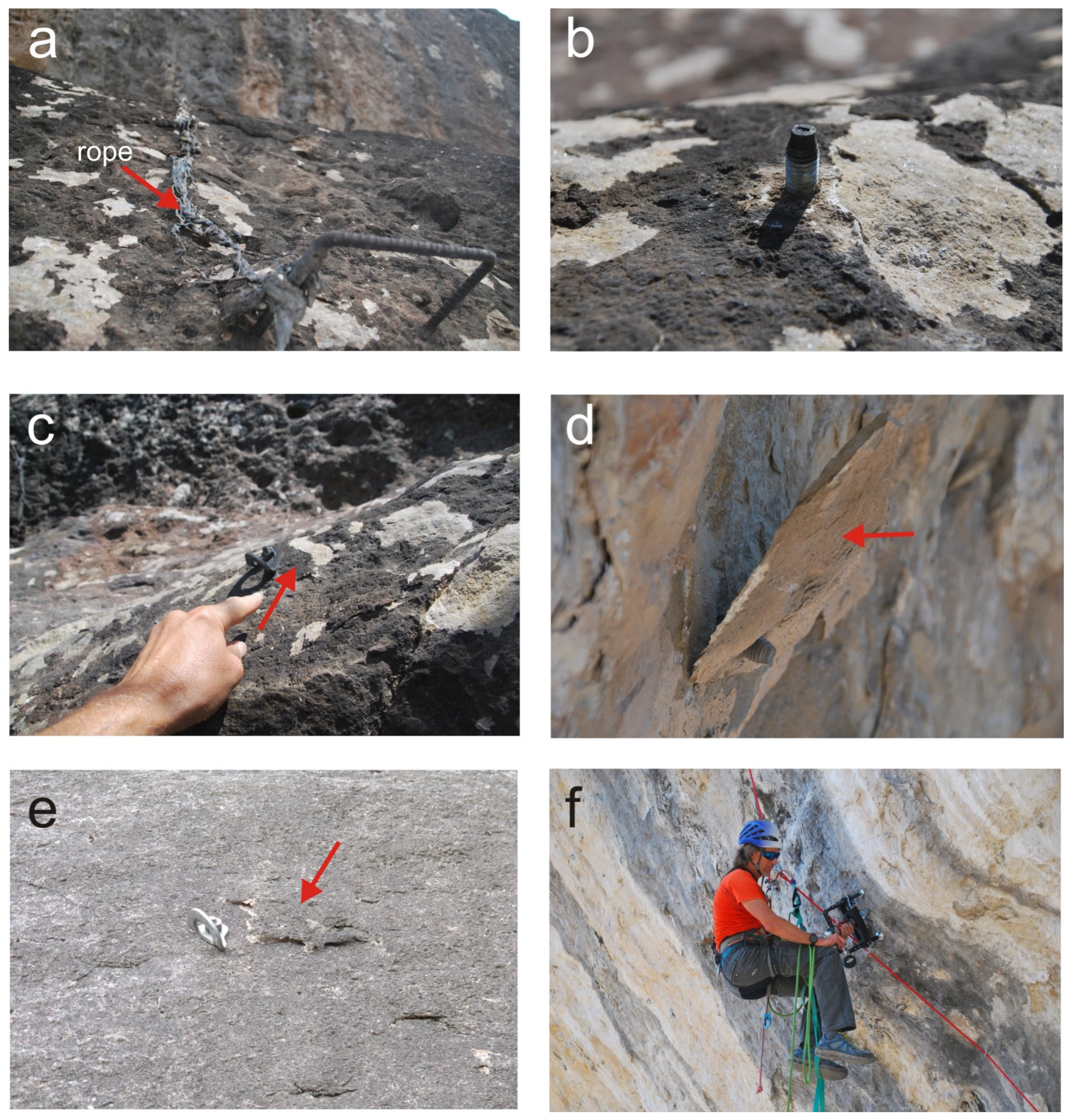
5.2. Impacts on Climbing and Other Associated Hazards
6. Discussion
7. Conclusions
Author Contributions
Funding
Informed Consent Statement
Data Availability Statement
Acknowledgments
Conflicts of Interest
References
- Gomez-Heras, M.; McCabe, S.; Smith, B.J.; Fort, R. Impacts of Fire on Stone-Built Heritage. J. Archit. Conserv. 2009, 2, 47–58. [Google Scholar] [CrossRef]
- Verdú, F.; Salas, J. Caracterización de Variables Biofísicas En Los Incendios Forestales Mayores de 25 Ha de La España Peninsular (1991–2005). Boletín de la Asociación de Geógrafos Españoles 2011, 57, 79–100. [Google Scholar]
- San-Miguel-Ayanz, J.; Durrant, T.; Boca, R.; Maianti, P.; Libertà, G.; Artés-Vivancos, T.; Oorn, D.; Branco, A.; De Rigo, D.; Ferrari, D.; et al. Forest Fires in Europe, Middle East and North Africa, EUR 30862; Publications Office of the European Union: Luxembourg, 2020. [Google Scholar] [CrossRef]
- López Santalla, A.; López García, M. Los Incendios Forestales en España—Decenio 2006–2015; Gobierno de Espana: Madrid, Spain, 2019. [Google Scholar]
- Vazquez, P.; Acuña, M.; Benavente, D.; Gibeaux, S.; Navarro, I.; Gomez-Heras, M. Evolution of Surface Properties of Ornamental Granitoids Exposed to High Temperatures. Constr. Build. Mater. 2016, 104, 263–275. [Google Scholar] [CrossRef]
- Vigroux, M.; Eslami, J.; Beaucour, A.L.; Bourgès, A.; Noumowé, A. High Temperature Behaviour of Various Natural Building Stones. Constr. Build. Mater. 2021, 272, 121629. [Google Scholar] [CrossRef]
- Vazquez, P.; Benavente, D.; Montiel, D.; Gomez-Heras, M. Mineralogical Transformations in Granitoids during Heating at Fire-Related Temperatures. Appl. Sci. 2022, 12, 188. [Google Scholar] [CrossRef]
- Kompaníková, Z.; Gomez-Heras, M.; Michňová, J.; Durmeková, T.; Vlčko, J. Sandstone alterations triggered by fire-related temperatures. Environ. Earth Sci. 2014, 72, 2569–2581. [Google Scholar] [CrossRef]
- Gripped. The Climbing Magazine. 2022. Available online: https://gripped.com/news/wildfires-are-burning-famous-rock-climbing-areas-in-spain/ (accessed on 10 October 2022).
- Climbing. Places—The Way to Tranquilo: How Spain is Paradise for Every Climber. 2013. Available online: https://www.climbing.com/places/the-way-to-tranquilo-how-spain-is-paradise-for-every-climber/ (accessed on 10 October 2022).
- The Crag. Welcome to the Largest Collaborative Rock Climbing & Bouldering Platform. 1999. Available online: https://www.thecrag.com/ (accessed on 22 October 2022).
- Outside Magazine. 5 Reasons Why Spain is a Climber’s Paradise 2017. Available online: https://www.outsideonline.com (accessed on 25 October 2022).
- Desnivel. Donde Escalar en España, 3rd ed.; Desnivel: Madrid, Spain, 2018; p. 378. [Google Scholar]
- Pezzatti, G.B.; Zumbrunnen, T.; Burgi, M. Fire regime shifts as a consequence of fire policy and socio-economic development: An analysis based on the change point approach. For. Policy Econ. 2013, 29, 7–18. [Google Scholar] [CrossRef]
- Rodrigues, M.; San Miguel, J.; Oliveira, S. An insight into spatial-temporal trends of fire ignitions and burned area in the European Mediterranean countries. J. Earth Sci. Eng. 2013, 3, 497–505. [Google Scholar]
- San-Miguel-Ayanz, J.; Rodrigues, M.; Santos, S.; Kemper, C.; Moreira, F.; Duguy, B.; Camia, A. Land Cover Change and Fire Regime in the European Mediterranean Region. In Post-Fire Management and Restoration of Southern European Forests; Moreira, F., Arianoutsou, M., Corona, P., De las Heras, J., Eds.; Springer: Amsterdam, The Netherlands, 2012; pp. 21–43. [Google Scholar]
- Burapapol, K.; Nagasawa, R. Assessment of Wildfire Risk at Recreational Sites in Sri Lanna National Park, Chiang Mai, Northern Thailand, using Remote Sensing and GIS Techniques. Int. J. Geoinform. 2017, 13, 13–24. [Google Scholar]
- Molina, J.R.; González-Cabán, A.; Silva, F.R. Wildfires impact on the economic susceptibility of recreation activities: Application in a Mediterranean protected area. J. Environ. Manag. 2019, 245, 454–463. [Google Scholar] [CrossRef]
- Ortega-Becerril, J.A.; Garrote, J.; Vicente, Á.; Marqués, M.J. Wildfire-Induced Changes in Flood Risk in Recreational Canyoning Areas: Lessons from the 2017 Jerte Canyons Disaster. Water 2022, 14, 2345. [Google Scholar] [CrossRef]
- Moropoulou, A.; Koui, M.; Tsiourva, T.H.; Kourteli, C.H.; Papasotiriou, D. Macro and Micro-Non Destructive Test for Environmental Impact Assesment on Architectural Surfaces. MRS Online Proc. Libr. 1996, 462, 343–349. [Google Scholar] [CrossRef]
- Moropoulou, A.; Labropoulos, K.C.; Delegou, E.T.; Karoglou, M.; Bakolas, A. Non-Destructive Techniques as a Tool for the Protection of Built Cultural Heritage. Constr. Build. Mater. 2013, 48, 1222–1239. [Google Scholar] [CrossRef]
- García-Rodríguez, M.; Gómez-Heras, M.; Fort, R.; Álvarez de Buergo, M. Control térmico de la meteorización de superficies endurecidas en rocas graníticas (La Pedriza de Manzanares, España). Boletín de la Sociedad Geológica Mexicana 2015, 67, 533–544. [Google Scholar] [CrossRef]
- Ortega-Becerril, J.; Gomez-Heras, M.; Fort, R.; Wohl, E. How does anisotropy in bedrock river granitic outcrops influence pothole genesis and development? Earth Surf. Process. Landf. 2017, 42, 956–968. [Google Scholar] [CrossRef]
- Climbing. Oliana Fire Destroys Bucket-List Climbs. 2022. Available online: https://www.climbing.com/news/oliana-fire/ (accessed on 15 November 2022).
- Lacrux Klettern Magazine. How Big is the Damage at the Climbing Area Oliana. 2022. Available online: https://www.lacrux.com/en/klettern/how-big-is-the-damage-at-the-climbing-area-oliana/ (accessed on 15 November 2022).
- UK Climbing (UKC). Oliana Fire Destroys Vegetation and Damages Climbing Routes. 2022. Available online: https://www.ukclimbing.com/news/2022/06/oliana_fire_destroys_vegetation_and_damages_climbing_routes-73085 (accessed on 15 November 2022).
- 8a.nu. Oliana Partly Destroyed by Fire. 2022. Available online: https://www.8a.nu/news/oliana-partly-destroyed-by-fire (accessed on 12 November 2022).
- Instituto Geológico y Minero de España (IGME). Inventario Español de Lugares de Interés Geológico (IELIG). 2013. Available online: http://info.igme.es/ielig/ (accessed on 20 October 2022).
- Ministerio Para la Transicion Ecologica y el Reto Demografico. La Red Natura 2000 en España. 2019. Available online: https://www.miteco.gob.es/es/biodiversidad/temas/espacios-protegidos/red-natura-2000/rn_espana.aspx (accessed on 8 November 2022).
- Agencia Estatal de Meteorología (AEMET). Atlas Climático: Visor Web. 2011. Available online: http://agroclimap.aemet.es (accessed on 8 November 2022).
- Vergés, J.; Martínez, A. Corte compensado del Pirineo oriental: Geometría de las cuencas de antepaís y edades de emplazamiento de los mantos de corrimiento. Acta Geológica Hispánica 1988, 23, 95–106. [Google Scholar]
- Berástegui, X.; Pi, M.E.; Escuer Solé, J.; Casanovas Petanas, J.; Samsó, J.M.; Arbués, P.; Martínez, L.; Vilella, A.; Barnolas Cortinas, A. Mapa geológico de la hoja No 291 (Oliana). In Mapa Geológico de España E, 1st ed.; Instituto Geologico y Minero de Espana: Madrid, Spain, 2017. [Google Scholar]
- Comunidad de Madrid. Montes de Utilidad Pública de la Comunidad de Madrid. 2007. Available online: https://www.comunidad.madrid/sites/default/files/doc/medio-ambiente/mup_catalogo_montes_utilidad_publica_fichas.pdf (accessed on 19 November 2022).
- Díaz de Neira, J.A.; López Olmedo, F.; Solé Pont, J.; Hernaiz, P.P.; Calvo Sorando, J.P.; Martín Serrano, A. Mapa geológico de la hoja No 580 (Villa del Prado). In Mapa Geológico de España, E, 1st ed.; Instituto Geologico y Minero de Espana: Madrid, Spain, 2007; p. 111. [Google Scholar]
- Freire-Lista, D.; Varas Murial, M.J.; Fort González, R. Deterioro en el granito de Cadalso de los Vidrios bajo condiciones de Hielo—Deshielo. Geogaceta 2010, 49, 2008–2011. [Google Scholar]
- Freire-Lista, D.M.; Fort, R.; Varas-Muriel, M.J. Thermal stress-induced microcracking in building granite. Eng. Geol. 2016, 206, 83–93. [Google Scholar] [CrossRef]
- European Union. Copernicus Land Monitoring Service; European Environment Agency (EEA): Copenhagen, Denmark, 2018. [Google Scholar]
- Key, C.H.; Benson, N.C. Measuring and remote sensing of burn severity. Jt. Fire Sci. Conf. Workshop Proc. 2000, 1999, 284–285. [Google Scholar]
- Lutes, D.C.; Keane, R.E.; Caratti, J.F.; Key, C.H.; Benson, N.C.; Sutherland, S.; Gangi, L.J. FIREMON: Fire Effects Monitoring and Inventory System; U.S. Department of Agriculture, Forest Service, Rocky Mountain Research Station: Fort Collins, CO, USA, 2006. [CrossRef]
- Hajpál, M. Changes in Sandstones of Historical Monuments Exposed to Fire or High Temperature. Fire Technol. 2002, 38, 373–382. [Google Scholar] [CrossRef]
- Ortega, J.A.; Gómez-Heras, M.; Perez-López, R.; Wohl, E.E. Multiscale structural and lithologic controls in the development of stream potholes on granite bedrock rivers. Geomorphology 2014, 204, 588–598. [Google Scholar] [CrossRef]
- García-Rodríguez, M.; Fernández Escalante, A.E. Geo-Climbing and Environmental Education: The Value of La Pedriza Granite Massif in the Sierra de Guadarrama National Park, Spain. Geoheritage 2017, 9, 141–151. [Google Scholar] [CrossRef]
- Álvarez de Buergo, M.; Gonzalez, M.T. Estudio del método de la medida de la velocidad de propagación del sonido y su aplicación a edificios históricos. Ing. Civ. 1994, 94, 69–74. [Google Scholar]
- Gomez-Heras, M.; Benavente, D.; Pla, C.; Martínez-Martínez, J.; Fort, R.; Brotons, V. Ultrasonic pulse velocity as a way of improving uniaxial compressive strength estimations from Leeb hardness measurements. Constr. Build. Mater. 2020, 261, 119996. [Google Scholar] [CrossRef]
- Keeley, J.E. Fire intensity, fire severity and burn severity: A brief review and suggested usage. Int. J. Wildland Fire 2009, 18, 116–126. [Google Scholar] [CrossRef]
- Buckman, S.; Morris, R.H.; Bourman, R.P. Fire-induced rock spalling as a mechanism of weathering responsible for flared slope and inselberg development. Nat. Commun. 2021, 12, 2150. [Google Scholar] [CrossRef]
- Zimmerman, S.G.; Evenson, E.B.; Gosse, J.C.; Erskine, C.P. Extensive boulder erosion resulting from a range fire on the type-Pinedale moraines, Fremont Lake, Wyoming. Quat. Res. 1994, 42, 255–265. [Google Scholar] [CrossRef]
- Shtober-Zisu, N.; Wittenberg, L. Wildfires as a Weathering Agent of Carbonate Rocks. Minerals 2021, 11, 1091. [Google Scholar] [CrossRef]
- Gomez-Heras, M.; Hajpál, M.; Álvarez de Buergo, M.; Török, A.; Fort, R.; Varas, M.J. Evolution of Porosity in Hungarian Building Stones after Simulated Burning. In Heritage Weathering and Conservation; Taylor & Francis: Rotterdam, The Netherlands, 2006; pp. 513–519. [Google Scholar]
- Just, J.; Kontny, A. Thermally induced alterations of minerals during measurements of the temperature dependence of magnetic susceptibility: A case study from the hydrothermally altered Soultz-sous-Forêts granite, France. Int. J. Earth Sci. 2012, 101, 819–839. [Google Scholar] [CrossRef]
- Ozguven, A.; Ozcelik, Y. Investigation of some property changes of natural building stones exposed to fire and high heat. Constr. Build. Mater. 2013, 38, 813–821. [Google Scholar] [CrossRef]
- Seron, F.J.; Gutierrez, D.; Magallon, J.; Ferragut, L.; Asensio, M.I. The evolution of a wildland forest fire front. Vis. Comput. 2005, 21, 152–169. [Google Scholar] [CrossRef]
- Liu, J.; Wang, Z.; Shi, W.; Tan, X. Experiments on the thermally enhanced permeability of tight rocks: A potential thermal stimulation method for Enhanced Geothermal Systems. Energy Sour. Part A Recovery Util. Environ. Eff. 2020, 1–14. [Google Scholar] [CrossRef]
- Shtober-Zisu, N.; Wittenberg, L. Long-term effects of wildfire on rock weathering and soil stoniness in the Mediterranean landscapes. Sci. Total Environ. 2021, 762, 1–11. [Google Scholar] [CrossRef]


| SEVERITY LEVEL | ||||
|---|---|---|---|---|
| Low Severity | Moderate–Low Severity | Moderate–High Severity | High Severity | |
| dNBR range | 0.1–0.269 | 0.27–0.439 | 0.44–0.59 | >0.66 |
| Oliana | 72.77 ha | 21.89 ha | - | - |
| Cadalso | 939.84 ha | 100.62 ha | 649.72 ha | 25 ha |
| Effects of Wildfires on Rock Surface Properties | Oliana | Cadalso de los Vidrios |
|---|---|---|
| Discoloration | low? | moderate |
| Extinction-related spalling | low? | moderate |
| Thermal spalling | high | low |
| Microcracks | ? | moderate |
| Partial calcination of calcite | moderate | n.a. 1 |
| Soot surface deposits | moderate | moderate–high |
| Statistics | Oliana (EM1-EM5) | Oliana (EM9-EM11) | Cadalso de los Vidrios |
|---|---|---|---|
| Mean | 13.7 | 9.9 | 7.8 |
| Standard Deviation | 16.3 | 10.3 | 3.9 |
| Median | 7.8 | 8.4 | 7.2 |
| Mode | 6.2 | 4.6 | 5.2 |
| Climbing Area and Site | Effect of Wildfire (1) | Bottom Part of the Wall | Middle Part of the Wall | Top Part of the Wall |
|---|---|---|---|---|
| Oliana | ||||
| EM1-EM4 | R/B/S | 70–100 | 30–70 | 0–30 |
| EM5-EM9 | U | 0 | 0 | n.f. |
| EM10-EM11 | B/S | 70–100 | n.f. | n.f. |
| Cadalso | ||||
| Site 1 | U/R | 0 | 0 | 0 |
| Site 2 | U | 0 | 0 | 0 |
| Site 3 | PB | 0 | 0 | 0 |
| Site 4 | PB/R/S | 0–30 | 0 | 0 |
| Site 5 | PB/R | 0–30 | 0 | 0 |
| Site 6 left | B/S | 30–70 | 0–30 | 0–30 |
| Site 6 center | R/B | 0–30 | 0 | 0 |
| Site 6 right | R/B | 0–30 | 0 | 0 |
| Impacts of Wildfires on Climbing Areas and Other Impacts | Oliana | Cadalso de los Vidrios |
|---|---|---|
| Route destruction | high | low |
| Boulder damage | n.a. 1 | high |
| Changes in route grading | moderate | low |
| Changes in rocky texture | moderate | moderate |
| Reduction in the climbing period 2 | high | moderate |
| Spalling affecting anchors | moderate | low |
| Anchor damage | none | none |
| Geoheritage damage | low 3 | n.a. 1 |
| Increase in geologic hazards 4 | high | moderate |
| Soil erosion in trails | low–moderate | moderate |
Disclaimer/Publisher’s Note: The statements, opinions and data contained in all publications are solely those of the individual author(s) and contributor(s) and not of MDPI and/or the editor(s). MDPI and/or the editor(s) disclaim responsibility for any injury to people or property resulting from any ideas, methods, instructions or products referred to in the content. |
© 2023 by the authors. Licensee MDPI, Basel, Switzerland. This article is an open access article distributed under the terms and conditions of the Creative Commons Attribution (CC BY) license (https://creativecommons.org/licenses/by/4.0/).
Share and Cite
Yeste-Lizán, P.; Gomez-Heras, M.; García-Rodríguez, M.; Pérez-López, R.; Carcavilla, L.; Ortega-Becerril, J.A. Surface Mechanical Effects of Wildfires on Rocks in Climbing Areas. Fire 2023, 6, 46. https://doi.org/10.3390/fire6020046
Yeste-Lizán P, Gomez-Heras M, García-Rodríguez M, Pérez-López R, Carcavilla L, Ortega-Becerril JA. Surface Mechanical Effects of Wildfires on Rocks in Climbing Areas. Fire. 2023; 6(2):46. https://doi.org/10.3390/fire6020046
Chicago/Turabian StyleYeste-Lizán, Pablo, Miguel Gomez-Heras, Manuel García-Rodríguez, Raúl Pérez-López, Luis Carcavilla, and Jose A. Ortega-Becerril. 2023. "Surface Mechanical Effects of Wildfires on Rocks in Climbing Areas" Fire 6, no. 2: 46. https://doi.org/10.3390/fire6020046
APA StyleYeste-Lizán, P., Gomez-Heras, M., García-Rodríguez, M., Pérez-López, R., Carcavilla, L., & Ortega-Becerril, J. A. (2023). Surface Mechanical Effects of Wildfires on Rocks in Climbing Areas. Fire, 6(2), 46. https://doi.org/10.3390/fire6020046